
When a strong earthquake hits an urban area, structures collapse, people are injured or killed, infrastructure is disrupted, and business interruption begins. The immediate impacts caused by an earthquake can be devastating to a community, challenging it to launch rescue efforts, restore essential services, and initiate the process of recovery. The ability of a community to recover from such a disaster reflects its resilience, and it is the many factors that contribute to earthquake resilience that are the focus of this report. Specifically, we provide a roadmap for building community resilience within the context of the Strategic Plan of the National Earthquake Hazards Reduction Program (NEHRP), a program first authorized by Congress in 1977 to coordinate the efforts of four federal agencies—National Institute of Standards and Technology (NIST), Federal Emergency Management Agency (FEMA), National Science Foundation (NSF), and U.S. Geological Survey (USGS).
The three most recent earthquake disasters in the United States all occurred in California—in 1994 near Los Angeles at Northridge, in 1989 near San Francisco centered on Loma Prieta, and in 1971 near Los Angeles at San Fernando. In each earthquake, large buildings and major highways were heavily damaged or collapsed and the economic activity in the afflicted area was severely disrupted. Remarkably, despite the severity of damage, deaths numbered fewer than a hundred for each event. Moreover, in a matter of days or weeks, these communities had restored many essential services or worked around major problems, completed rescue efforts, and economic activity—although impaired—had begun to recover. It could be argued that these communities were, in fact, quite resilient. But
it should be emphasized that each of these earthquakes was only moderate to strong in size, less than magnitude-7, and that the impacted areas were limited in size. How well would these communities cope with a magnitude-8 earthquake? What lessons can be drawn from the resilience demonstrated for a moderate earthquake in preparing for a great one?
Perhaps experience in dealing with hurricane disasters would be instructive in this regard. In a typical year, a few destructive hurricanes make landfall in the United States. Most of them cause moderate structural damage, some flooding, limited disruption of services—usually loss of power—and within a few days, activity returns to near normal. However, when Hurricane Katrina struck the New Orleans region in 2005 and caused massive flooding and long-term evacuation of much of the population, the response capabilities were stretched beyond their limits. Few observers would argue that New Orleans, at least in the short term, was a resilient community in the face of that event.
Would an earthquake on the scale of the 1906 event in northern California or the 1857 event in southern California lead to a similar catastrophe? It is likely that an earthquake on the scale of these events in California would indeed lead to a catastrophe similar to hurricane Katrina, but of a significantly different nature. Flooding, of course, would not be the main hazard, but substantial casualties, collapse of structures, fires, and economic disruption could be of great consequence. Similarly, what would happen if there were to be a repeat of the New Madrid earthquakes of 1811-1812, in view of the vulnerability of the many bridges and chemical facilities in the region and the substantial barge traffic on the Mississippi River? Or, consider the impact if an earthquake like the 1886 Charleston tremor struck in other areas in the central or eastern United States, where earthquake-prone, unreinforced masonry structures abound and earthquake preparedness is not a prime concern? The resilience of communities and regions, and the steps—or roadmap—that could be taken to ensure that areas at risk become earthquake resilient, are the subject of this report.
Earthquakes proceed as cascades, in which the primary effects of faulting and ground shaking induce secondary effects such as landslides, liquefaction, and tsunami, which in turn set off destructive processes within the built environment such as fires and dam failures (NRC, 2003). The socioeconomic effects of large earthquakes can reverberate for decades.
The seismic hazard for a specified site is a probabilistic forecast of how intense the earthquake effects will be at that site. In contrast, seismic risk is a probabilistic forecast of the damage to society that will be caused by earthquakes, usually measured in terms of casualties and economic losses in a
specified area integrated over the post-earthquake period. Risk depends on the hazard, but it is compounded by a community’s exposure—its population and the extent and density of its built environment—as well as the fragility of its built environment, population, and socioeconomic systems to seismic hazards. Exposure and fragility contribute to vulnerability. Risk is lowered by resiliency, the measure of how efficiently and how quickly a community can recover from earthquake damage.
Risk analysis seeks to quantify the risk equation in a framework that allows the impact of political policies and economic investments to be evaluated, to inform the decision-making processes that contribute to risk reduction. Risk quantification is a difficult problem, because it requires detailed knowledge of the natural and the built environments, as well as an understanding of both earthquake and human behaviors. Moreover, national risk is a dynamic concept because of the exponential rise in the urban exposure to seismic hazards (EERI, 2003b)—calculating risk involves predictions of highly uncertain demographic trends.
Estimating Losses from Earthquakes
The synoptic earthquake risk studies needed for policy formulation are the responsibility of NEHRP. These studies can take the form of deterministic or scenario studies where the effects of a single earthquake are modeled, or probabilistic studies that weight the effects from a number of different earthquake scenarios by the annual likelihood of their occurrence. The consequences are measured in terms of dollars of damage, fatalities, injuries, tons of debris generated, ecological damage, etc. The exposure period may be defined as the design lifetime of a building or some other period of interest (e.g., 50 years). Typically, seismic risk estimates are presented in terms of an exceedance probability (EP) curve (Kunreuther et al., 2004), which shows the probability that specific parameters will equal or exceed specified values (Figure 1.1). On this figure, a loss estimate calculated for a specific scenario earthquake is represented by a horizontal slice through the EP curve, while estimates of annualized losses from earthquakes are portrayed by the area under the EP curve.
The 2008 Great California ShakeOut exercise in southern California is an example of a scenario study that describes what would happen during and after a magnitude-7.8 earthquake on the southernmost 300 km of the San Andreas Fault (Figure 1.2), a plausible event on the fault that is most likely to produce a major earthquake. Analysis of the 2008 ShakeOut scenario, which involved more than 5,000 emergency responders and the participation of more than 5.5 million citizens, indicated that the scenario earthquake would have resulted in an estimated 1,800 fatalities, $113 billion in damages to buildings and lifelines, and nearly $70 billion in busi-
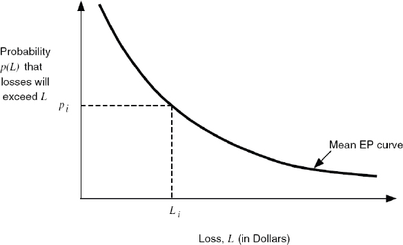
FIGURE 1.1 Sample mean EP curve, showing that for a specified event the probability of insured losses exceeding Li is given by pi. SOURCE: Kunreuther et al. (2004).
ness interruption (Jones et al., 2008; Rose et al., in press). The broad areal extent and long duration of water service outages was the main contributor to business interruption losses. Moreover, the scenario is essentially a compound event like Hurricane Katrina, with the projected urban fires caused by gas main breaks and other types of induced accidents projected to cause $40 billion of the property damage and more than $22 billion of the business interruption. Devastating fires occurred in the wake of the 1906 San Francisco, 1923 Tokyo, and 1995 Kobe earthquakes.
Loss estimates have been published for a range of earthquake scenarios based on historic events—e.g., the 1906 San Francisco earthquake (Kircher et al., 2006); the 1811/1812 New Madrid earthquakes (Elnashai et al., 2009); and the magnitude-9 Cascadia subduction earthquake of 1700 (CREW, 2005)—or inferred from geologic data that show the magnitudes and locations of prehistoric fault ruptures (e.g., the Puente Hills blind thrust that runs beneath central Los Angeles; Field et al., 2005). In all cases, the results from such estimates are staggering, with economic losses that run into the hundreds of billions of dollars.
FEMA’s latest estimate of Annualized Earthquake Loss (AEL) for the nation (FEMA, 2008) is an example of a probabilistic study—an estimate of national earthquake risk that used HAZUS-MH software (Box 1.1) together with input from Census 2000 data and the 2002 USGS National Seismic Hazard Map. The current AEL estimate of $5.3 billion (2005$)
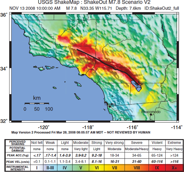
FIGURE 1.2 A “ShakeMap” representing the shaking produced by the scenario earthquake on which the Great California ShakeOut was based. The colors represent the Modified Mercalli Intensity, with warmer colors representing areas of greater damage. SOURCE: USGS. Available at earthquake.usgs.gov/earthquakes/shakemap/sc/shake/ShakeOut2_full_se/.
reflects building-related direct economic losses including damage to buildings and their contents, commercial inventories, as well as damaged building-related income losses (e.g., wage losses, relocation costs, rental income losses, etc.), but does not include indirect economic losses or losses to lifeline systems. For comparison, the Earthquake Engineering Research Institute (EERI) (2003b) extrapolated the FEMA (2001) estimate of AEL ($4.4 billion) for residential and commercial building-related direct economic losses by a factor of 2.5 to include indirect economic losses, the social costs of death and injury, as well as direct and indirect losses to the
BOX 1.1
HAZUS®—Risk Metrics for NEHRP
The ability to monitor and compare seismic risk across states and regions is critical to the management of NEHRP. At the state and local level, an understanding of seismic risk is important for planning and for evaluating costs and benefits associated with building codes, as well as a variety of other prevention measures. HAZUS is Geographic Information System (GIS) software for earthquake loss estimation that was developed by FEMA in cooperation with the National Institute of Building Sciences (NIBS). HAZUS-MH (Hazards U.S.-Multi-Hazard) was released in 2003 to include wind and flood hazards in addition to the earthquake hazards that were the subject of the 1997 and 1999 HAZUS releases. Successive HAZUS maintenance releases (MR) have been made available by FEMA since the initial HAZUS-MH MR-1 release; the latest version, HAZUS-MH MR-5, was released in December 2010.
Annualized Earthquake Loss (AEL) is the estimated long-term average of earthquake losses in any given year for a specific location. Studies by FEMA based on the 1990 and 2000 censuses provide two “snapshots” of seismic risk in the United States (FEMA, 2001, 2008). These studies, together with an earlier analysis of the 1970 census by Petak and Atkisson (1982), show that the estimated national AEL increased from $781 million (1970$) to $4.7 billion (2000$)—or by about 40 percent—over four decades (Figure 1.3). All three studies used building-related direct economic losses and included structural and nonstructural replacement costs, contents damage, business inventory losses, and direct business interruption losses.
industrial, manufacturing, transportation, and utility sectors to arrive at an annual average financial loss in excess of $10 billion.
Although the need to address earthquake risk is now accepted in many communities, the ability to identify and act on specific hazard and risk issues can be improved by reducing the uncertainties in the risk equation. Large ranges in loss estimates generally stem from two types of uncertainty—the natural variability assigned to earthquake processes (aleatory uncertainty), as well as a lack of knowledge of the true hazards and risks involved (epistemic uncertainty). Uncertainties are associated with the methodologies, the assumptions, and databases used to estimate the ground motions and building inventories, the modeling of building responses, and the correlation of expected economic and social losses to the estimated physical damages.
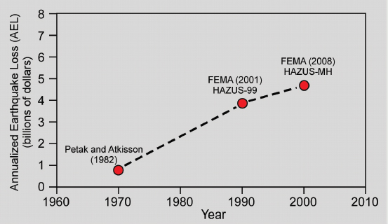
FIGURE 1.3 Growth of seismic risk in the United States. Annualized Earthquake Loss (AEL) estimates are shown for the census year on which the estimate is based, in census year dollars. Estimate for 1970 census from Petak and Atkinson (1982); HAZUS-99 estimate for 1990 census from FEMA (2001); and HAZUS-MH estimate for 2000 census from FEMA (2008). Consumer Price Index (CPI) dollar adjustments based on CPI inflation calculator (see data.bls.gov/cgi-bin/cpicalc.pl).
Comparison of published risk estimates reveals the sensitivity of such estimates to varying inputs, such as soil types and ground motion attenuation models, or building stock inventories and damage calculations. The basic earth science and geotechnical research and data that the NEHRP agencies provide to communities help to reduce these types of epistemic uncertainty, whereas an understanding of the intrinsic aleatory uncertainty is achieved through scientific research into the processes that cause earthquakes. Accurate loss estimation models increase public confidence in making seismic risk management decisions. Until the uncertainties surrounding the EP curve in Figure 1.1 are reduced, there will be either unnecessary or insufficient emergency response planning and mitigation because the experts in these areas will be unable to inform decision-makers of the probabilities and potential outcomes with an appropriate degree of
confidence (NRC, 2006a). Information about new and rehabilitated buildings and infrastructure, coupled with improved seismic hazard maps, can allow policy-makers to track incremental reductions in risk and improvements in safety through earthquake mitigation programs (NRC, 2006b).
NEHRP ACCOMPLISHMENTS—THE PAST 30 YEARS
In its 30 years of existence, NEHRP has provided a focused, coordinated effort toward developing a knowledge base for addressing the earthquake threat. The following summary of specific accomplishments from the earth sciences and engineering fields are based on the 2008 NEHRP Strategic Plan (NIST, 2008):
• Improved understanding of earthquake processes. Basic research and earthquake monitoring have significantly advanced the understanding of the geologic processes that cause earthquakes, the characteristics of earthquake faults, the nature of seismicity, and the propagation of seismic waves. This understanding has been incorporated into seismic hazard assessments, earthquake potential assessments, building codes and design criteria, rapid assessments of earthquake impacts, and scenarios for risk mitigation and response planning.
• Improved earthquake hazard assessment. Improvements in the National Seismic Hazard Maps have been developed through a scientifically defensible and repeatable process that involves peer input and review at regional and national levels by expert and user communities. Once based on six broad zones, they now are based on a grid of seismic hazard assessments at some 150,000 sites throughout the country. The new maps, first developed in 1996, are periodically updated and form the basis for the Design Ground Motion Maps used in the NEHRP Recommended Provisions for Seismic Regulations for New Buildings and Other Structures, the foundation for the seismic elements of model building codes.
• Improved earthquake risk assessment. Development of earthquake hazard- and risk-assessment techniques for use throughout the United States has improved awareness of earthquake impacts on communities. NEHRP funds have supported the development and continued refinement of HAZUS-MH. The successful NEHRP-supported integration of earthquake risk-assessment and loss-estimation methodologies with earthquake hazard assessments and notifications has provided significant benefits for both emergency response and community planning. Moreover, major advances in risk assessment and hazard loss estimation beyond what could be included in a software package for general users were developed by the three NSF-supported earthquake engineering centers.
• Improved earthquake safety in design and construction. Earthquake safety in new buildings has been greatly improved through the adoption, in whole or in part, of earthquake-resistant national model building codes by state and local governments in all 50 states. Development of advanced earthquake engineering technologies for use in design and construction has greatly improved the cost-effectiveness of earthquake-resistant design and construction while giving options with predicted decision consequences. These techniques include new methods for reducing the seismic risk associated with nonstructural components, base isolation methods for dissipating seismic energy in buildings, and performance-based design approaches.
• Improved earthquake safety for existing buildings. NEHRP-led research, development of engineering guidelines, and implementation activities associated with existing buildings have led to the first generation of consensus-based national standards for evaluating and rehabilitating existing buildings. This work provided the basis for two American Society of Civil Engineers (ASCE) standards documents: ASCE 31 (Seismic Evaluation of Existing Buildings) and ASCE 41 (Seismic Rehabilitation of Existing Buildings).
• Development of partnerships for public awareness and earthquake mitigation. NEHRP has developed and sustained partnerships with state and local governments, professional groups, and multi-state earthquake consortia to improve public awareness of the earthquake threat and support the development of sound earthquake mitigation policies.
• Improved development and dissemination of earthquake information. There is now a greatly increased body of earthquake-related information available to public- and private-sector officials and the general public. This comes through effective documentation, earthquake response exercises, learning-from-earthquake activities, publications on earthquake safety, training, education, and information on general earthquake phenomena and means to reduce their impact. Millions of earthquake preparedness handbooks have been delivered to at-risk populations, and many of these handbooks have been translated from English into languages most easily understood by large sectors of the population. NEHRP now maintains a website1 that provides information on the program and communicates regularly with the earthquake professional community through the monthly electronic newsletter, Seismic Waves.
• Improved notification of earthquakes. The USGS National Earthquake Information Center and regional networks, all elements of the Advanced National Seismic System (ANSS), now provide earthquake
_________________
1 See www.nehrp.gov.
alerts describing a magnitude and location within a few minutes after an earthquake. The USGS PAGER system2 provides estimates of the number of people and the names of cities exposed to shaking, with corresponding levels of impact shown by the Modified Mercalli Intensity scale and estimates of the number of fatalities and economic loss, following significant earthquakes worldwide (Figure 1.4). When coupled with graphic ShakeMaps3 showing the distribution and severity of ground shaking (e.g., Chapter 3, Figure 3.2), this information is essential for effective emergency response, infrastructure management, and recovery planning.
• Expanded training and education of earthquake professionals. Thousands of graduates of U.S. colleges and universities have benefited from their involvement and experiences with NEHRP-supported research projects and training activities. Those graduates now form the nucleus of America’s earthquake professional community.
• Development of advanced data collection and research facilities. NEHRP took the lead in developing ANSS and the George E. Brown, Jr. Network for Earthquake Engineering Simulation (NEES). Through these initiatives, NEES now forms a national infrastructure for testing geotechnical, structural, and nonstructural systems, and once completed, ANSS will provide a comprehensive, nationwide system for monitoring seismicity and collecting data on earthquake shaking on the ground and in structures. NEHRP also has participated in the development of the Global Seismographic Network to provide data on seismic events worldwide.
As well as this list of important accomplishments cited in the 2008 NEHRP Strategic Plan, the following range of NEHRP accomplishments in the social science arena were described in NRC (2006a):
• Development of a comparative research framework. Largely supported by NEHRP, over the past three decades social scientists increasingly have placed the study of earthquakes within a comparative framework that includes other natural, technological, and willful events. This evolving framework calls for the integration of hazards and disaster research within the social sciences and among social science, natural science, and engineering disciplines.
• Documentation of community and regional vulnerability to earthquakes and other natural hazards. Under NEHRP sponsorship, social science knowledge has expanded greatly in terms of data on community and regional exposure and vulnerability to earthquakes and other natural hazards, such that the foundation has been established for devel-
_________________
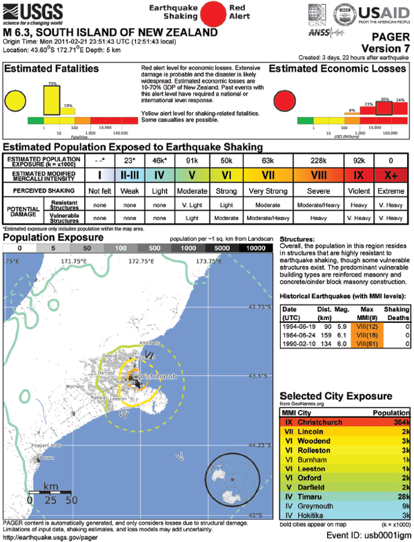
FIGURE 1.4 Sample PAGER output for the strong and damaging February 2011 earthquake in Christchurch, New Zealand. SOURCE: USGS. Available at earthquake.usgs.gov/earthquakes/pager/events/us/b0001igm/index.html.
oping more precise loss estimation models and related decision support tools (e.g., HAZUS). The vulnerabilities are increasingly documented through state-of-the-art geospatial and temporal methods (e.g., GIS, remote sensing, and visual overlays of hazardous areas with demographic information), and the resulting data are equally relevant to pre-, trans-, and post-disaster social science investigations.
• Household and business-sector adoption of self-protective measures. A solid knowledge base has been developed under NEHRP at the household level on vulnerability assessment, risk communication, warning response (e.g., evacuation), and the adoption of other forms of protective action (e.g., emergency food and water supplies, fire extinguishers, procedures and tools to cut off utilities, hazard insurance). Adoption of these and other self-protective measures has been modeled systematically, highlighting the importance of disaster experience and perceptions of personal risk (i.e., beliefs about household vulnerability to and consequences of specific events) and, to a lesser extent, demographic variables (e.g., income, education, home ownership) and social influences (e.g., communications patterns and observations of what other people are doing). Although research on adoption of self-protective measures of businesses is much more limited, recent experience of disaster-related business or lifeline interruptions has been shown to be correlated with greater preparedness activities, at least in the short run. Such preparedness activities are more likely to occur in larger as opposed to smaller commercial enterprises.
• Public-sector adoption of disaster mitigation measures. Most NEHRP-sponsored social science research has focused on the politics of hazard mitigation as they relate to intergovernmental issues in land-use regulations. The highly politicized nature of these regulations has been well documented, particularly when multiple layers of government are involved. Governmental conflicts regarding responsibility for the land-use practices of households and businesses are compounded by the involvement of other stakeholders (e.g., bankers, developers, industry associations, professional associations, other community activists, and emergency management practitioners). The results are complex social networks of power relationships that constrain the adoption of hazard mitigation policies and practices at local and regional levels.
• Hazard insurance issues. NEHRP-sponsored social research has documented many difficulties in developing and maintaining an actuarially sound insurance program for earthquakes and floods—those who are most likely to purchase earthquake and flood insurance are, in fact, those who are most likely to file claims. This problem makes it virtually impossible to sustain an insurance market in the private sector for these hazards. Economists and psychologists have documented in laboratory studies
a number of logical deficiencies in the way people process information related to risks as it relates to insurance decision-making. Market failure in earthquake and flood insurance remains an important social science research and public policy issue.
• Public-sector adoption of disaster emergency and recovery preparedness measures. NEHRP-sponsored social science studies of emergency preparedness have addressed the extent of local support for disaster preparedness, management strategies for improving the effectiveness of community preparedness, the increasing use of computer and communications technologies in disaster planning and training, the structure of community preparedness networks, and the effects of disaster preparedness on both pre-determined (e.g., improved warning response and evacuation behavior) and improvised (e.g., effective ad hoc uses of personnel and resources) responses during actual events. Thus far there has been little social science research on the disaster recovery aspect of preparedness.
• Social impacts of disasters. A solid body of social science research supported by NEHRP has documented the destructive impacts of disasters on residential dwellings and the processes people go through in housing recovery (emergency shelter, temporary sheltering, temporary housing, and permanent housing), as well as analogous impacts on businesses. Documented specifically are the problems faced by low-income households, which tend to be headed disproportionately by females and racial or ethnic minorities. Notably, there has been little social science research under NEHRP on the impacts of disasters on other aspects of the built environment. There is a substantial research literature on the psychological, social, and economic and (to a lesser extent) political impacts of disaster, which suggests that these impacts, while not random within impacted populations, are generally modest and transitory.
• Post-disaster responses by the public and private sectors. Research before and since the establishment of NEHRP in 1977 has contradicted misconceptions that during disasters, panic will be widespread, that large percentages of those who are expected to respond will simply abandon disaster relief roles, that local institutions will break down, that crime and other forms of anti-social behavior will be rampant, and that the mental impairment of victims and first responders will be a major problem. Existing and ongoing research is documenting and modeling the mix of expected and improvised responses by emergency management personnel, the public and private organizations of which they are members, and the multi-organizational networks within which these individual and organizational responses are nested. As a result of this research, a range of decision support tools is now being developed for emergency management practitioners.
• Post-disaster reconstruction and recovery by the public and private sectors. Prior to NEHRP relatively little was known about disas-
ter recovery processes and outcomes at different levels of analysis (e.g., households, neighborhoods, firms, communities, and regions). NEHRP-funded projects have helped to refine general conceptions of disaster recovery, made important contributions in understanding the recovery of households and communities (primarily) and businesses (more recently), and contributed to the development of statistically based community and regional models of post-disaster losses and recovery processes.
• Research on resilience has been a major theme of the NSF-supported earthquake research centers. The Multidisciplinary Center for Earthquake Engineering Research (MCEER) sponsored research providing operational definitions of resilience, measuring its cost and effectiveness, and designing policies to implement it at the level of the individual household, business, government, and nongovernment institution. The Mid-American Earthquake Center (MAE) sponsored research on the promotion of earthquake-resilient regions.
ROADMAP CONTEXT—THE EERI REPORT AND NEHRP STRATEGIC PLAN
The 2008 NEHRP Strategic Plan calls for an accelerated effort to develop community resilience. The plan defines a vision of “a nation that is earthquake resilient in public safety, economic strength, and national security,” and articulates the NEHRP mission “to develop, disseminate, and promote knowledge, tools, and practices for earthquake risk reduction—through coordinated, multidisciplinary, interagency partnerships among NEHRP agencies and their stakeholders—that improve the Nation’s earthquake resilience in public safety, economic, strength, and national security.” The plan identifies three goals with fourteen objectives (listed below), plus nine strategic priorities (presented in Appendix A).
Goal A: Improve understanding of earthquake processes and impacts.
Objective 1: Advance understanding of earthquake phenomena and generation processes.
Objective 2: Advance understanding of earthquake effects on the built environment.
Objective 3: Advance understanding of the social, behavioral, and economic factors linked to implementing risk reduction and mitigation strategies in the public and private sectors.
Objective 4: Improve post-earthquake information acquisition and management.
Goal B: Develop cost-effective measures to reduce earthquake impacts on individuals, the built environment, and society-at-large.
Objective 5: Assess earthquake hazards for research and practical application.
Objective 6: Develop advanced loss estimation and risk assessment tools.
Objective 7: Develop tools that improve the seismic performance of buildings and other structures.
Objective 8: Develop tools that improve the seismic performance of critical infrastructure.
Goal C: Improve the earthquake resilience of communities nationwide.
Objective 9: Improve the accuracy, timeliness, and content of earthquake information products.
Objective 10: Develop comprehensive earthquake risk scenarios and risk assessments.
Objective 11: Support development of seismic standards and building codes and advocate their adoption and enforcement.
Objective 12: Promote the implementation of earthquake-resilient measures in professional practice and in private and public policies.
Objective 13: Increase public awareness of earthquake hazards and risks.
Objective 14: Develop the nation’s human resource base in earthquake safety fields.
Although the Strategic Plan does not specify the activities that would be required to reach its goals, in the initial briefing to the committee NIST, the NEHRP lead agency, described the 2003 report by the EERI, Securing Society Against Catastrophic Earthquake Losses, as at least a starting point. The EERI report lists specific activities—and estimates costs—for a range of research programs (presented in Appendix B) that are in broad accord with the goals laid out in the 2008 NEHRP Strategic Plan. The committee was asked to review, update, and validate the programs and cost estimates laid out in the EERI report.
COMMITTEE CHARGE AND SCOPE OF THIS STUDY
The National Institute of Standards and Technology—the lead NEHRP agency—commissioned the National Research Council (NRC) to undertake a study to assess the activities, and their costs, that would be required for the nation to achieve earthquake resilience in 20 years (Box 1.2). The charge
BOX 1.2
Statement of Task
A National Research Council committee will develop a roadmap for earthquake hazard and risk reduction in the United States. The committee will frame the road map around the goals and objectives for achieving national earthquake resilience in public safety and economic security stated in the current strategic plan of the National Earthquake Hazard Reduction Program (NEHRP) submitted to Congress in 2008. This roadmap will be based on an analysis of what will be required to realize the strategic plan’s major technical goals for earthquake resilience within 20 years. In particular, the committee will:
• Host a national workshop focused on assessing the basic and applied research, seismic monitoring, knowledge transfer, implementation, education, and outreach activities needed to achieve national earthquake resilience over a twenty-year period.
• Estimate program costs, on an annual basis, that will be required to implement the roadmap.
• Describe the future sustained activities, such as earthquake monitoring (both for research and for warning), education, and public outreach, which should continue following the 20-year period.
to the committee recognized that there would be a requirement for some sustained activities under the NEHRP program after this 20-year period.
To address the charge, the NRC assembled a committee of 12 experts with disciplinary expertise spanning earthquake and structural engineering; seismology, engineering geology, and earth system science; disaster and emergency management; and the social and economic components of resilience and disaster recovery. Committee biographic information is presented in Appendix C.
The committee held four meetings between May and December, 2009, convening twice in Washington, DC; and also in Irvine, CA; and Chicago, IL (see Appendix D). The major focal point for community input to the committee was a 2-day open workshop held in August 2009, where concurrent breakout sessions interspersed with plenary addresses enabled the committee to gain a thorough understanding of community perspectives regarding program needs and priorities. Additional briefings by NEHRP agency representatives were presented during open sessions at the initial and final committee meetings.
Report Structure
Building on the 2008 NEHRP Strategic Plan and the EERI report, this report analyses the critical issues affecting resilience, identifies challenges and opportunities in achieving that goal, and recommends specific actions that would comprise a roadmap to community resilience. Because the concept of “resilience” is a fundamental tenet of the roadmap for realizing the major technical goals of the NEHRP Strategic Plan, Chapter 2 presents an analysis of the concept of resilience, a description of the characteristics of a resilient community, resilience metrics, and a description of the benefits to the nation of a resilience-based approach to hazard mitigation. Chapter 3 contains descriptions of the 18 broad, integrated tasks comprising the elements of a roadmap to achieve national earthquake resilience focusing on the specific outcomes that could be achieved in a 20-year timeframe, and the elements realizable within 5 years. These tasks are described in terms of the proposed activity and actions, existing knowledge and current capabilities, enabling requirements, and implementation issues. Costs to implement these 18 tasks are presented in Chapter 4, in as much detail as possible within the constraint that some components have been the subject of specific, detailed costing exercises whereas others are necessarily broad-brush estimates at this stage. The final chapter briefly summarizes the major elements of the roadmap.


