
Physiographic, Oceanographic, and
Ecological Context of the Gulf of Mexico
Unique aspects of the Gulf of Mexico (GoM), its abundant hydrocarbon resources and the exceptional habitat and ecosystems at risk, cannot be understood without an initial consideration of the processes responsible for creation and maintenance of the basin and its ecosystems. Thus, we begin our report with an overview of the geographic, oceanographic, and ecological setting of the GoM. It is only within this context that we can properly identify appropriate approaches for delineating, quantifying, and valuing the impact of the Deepwater Horizon Mississippi Canyon-252 (DWH) oil spill on ecosystem services and hope to understand the complex and dynamically changing baselines associated with the GoM. We also recognize that the term “baseline” has a specific meaning in the context of the Natural Resource Damage Assessment program (see Definitions in Introduction) and will endeavor to incorporate that into our analysis and discussion.
GEOLOGIC AND PHYSIOGRAPHIC SETTING
The modern GoM originated approximately 200 million years ago (mya) with rifting of the supercontinent of Pangaea. As this rifting continued, the continental crust thinned and eventually shallow basins were flooded with sea water through a connection to the Pacific Ocean. During this time (approximately 180-200 mya) thick deposits of salt and other evaporates accumulated in the shallow basin (Salvador, 1991). Today this salt plays a key role in creating an environment that is conducive to the accumulation and production of hydrocarbons. As rifting continued, the basin deepened, the Yucatan Peninsula rotated from Florida (Pindell and Kennan, 2009), Atlantic waters entered, and salt deposition stopped. The overall process resulted in a shelf-rimmed basin approximately 3,500 m deep with steep carbonate banks at the eastern (West Florida Escarpment) and southern (Campeche Escarpment) margins (Figure 1.1).
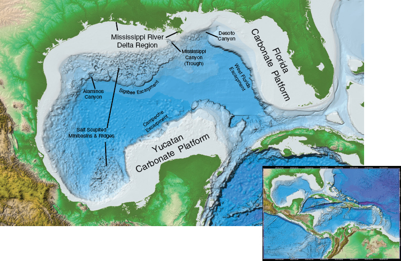
FIGURE 1.1 ETOPO1 Global Relief Model of the Gulf of Mexico Large Marine Ecosystem with inset of the Gulf-Caribbean complex (based on data from Amante and Eakins, 2009).
SOURCE: Based on data from Amante, C. and B. W. Eakins, ETOPO1 1 Arc-Minute Global Relief Model: Procedures, Data Sources and Analysis. NOAA Technical Memorandum NESDIS NGDC-24, 19 pp, March 2009. Image constructed using Fledermaus visualization software (http://www.ivs3d.com/products/fledermaus/).
Since the time of this rifting and deepening of the basin (about 180 mya), the GoM has continuously received large amounts of sediment from the surrounding continents with by far the greatest input coming from the central portion of the North American continent. The modern Mississippi and Atchafalaya rivers, with their extensive deltas and a deep-sea fan, are the most recent manifestations of this sedimentation. The organic debris, particulates, and dissolved nutrients introduced into the Gulf by these rivers ensured high primary productivity, high carbon-content sediments, and abundant hydrocarbon resource rocks. The subsidence of the basin along with the massive sediment loads provided by river input created the appropriate burial conditions (pressure and heat) to form oil and gas from these source rocks. Movement of the deeply buried salt created traps and paths
for the oil and gas as well as a unique morphology of basins and domes in some areas of the slope (Figure 1.1). The GoM was, through its geologic past, an ideal environment for the generation and accumulation of recoverable hydrocarbon resources.
The entire continental margin in the northern GoM continues to be shaped by high sediment loads and the movement of salt within the strata of the margin. The salt tectonics (movement) generates hydrocarbon migration paths from source to reservoir. The Macondo well targeted hydrocarbons trapped in Miocene (~12 mya) sand strata that are bounded by several salt dome features. Frequently, the migration paths lead to the sediment surface (Roberts and Carney, 1997) resulting in the creation of cold seep communities dependent on chemically extreme conditions. Seepage from these conduits results in the natural injection of gas, liquid hydrocarbons, and brines into the deep water of the Gulf.
In addition to the impact of salt migration, typical margin-forming processes like sea-level change, erosion, and currents have also shaped the margin and impacted the creation of submarine canyons. The result is a series of seafloor ridges, minibasins, canyons, and escarpments (Jackson et al., 2010) (Figure 1.1). As topographically complex as the Gulf margin is, however, the largest portion of this system is blanketed with sediments built up from terrestrial runoff and from the remains of pelagic organisms forming a vast soft-bottom habitat.
DELTA ENVIRONMENTS AND NEARSHORE HABITATS
The Mississippi River system has long dominated the geological and biological landscape of the northern GoM. The watershed encompasses 41 percent of the lower 48 United States (~3.2 × 10⁶ km2) surpassed in size only by the Amazon and Zaire rivers (Milliman and Meade, 1983; Meade, 1996). The river’s length and discharge of freshwater and sediment rank it among the world’s top ten rivers. The annual average freshwater discharge of 580 km3 enters the northern GoM through two main distributaries: the Mississippi River delta southeast of the city of New Orleans, Louisiana, and the Atchafalaya River delta ~200 km to the west on the central Louisiana coast (Meade, 1995).
Sediment deposition and accumulation are essential for maintaining the delta, offsetting natural subsidence, and preventing drowning of wetlands. Over tens of thousands of years, the flow of sediment-laden freshwater created a series of delta lobes that prograded (moved seaward), subsided, and switched across the northern Gulf coastal landscape, establishing a deltaic
plain that eventually formed the current Mississippi River delta about 1,000 years ago (Penland et al., 1988). Alongshore flow of water and sandy sediments formed ridges and cheniers (historic barrier ridges) at different locations as sea level changed, which, in turn, provided forested canopy areas. As the delta formation prograded, barrier island arcs formed. Over time the barrier islands fragmented into smaller islands with coastal lagoons. Smaller rivers created smaller deltas or drowned river basins that became bays and estuaries. Multiple habitats were shaped over geologic time, which continue to experience natural evolution modified by human activities and the persistent need for sediment input to counteract increasing sea level rise.
Wetlands across the coast were historically sustained by substantial input of river sediments. Over two centuries, the transformation to a primarily agricultural landscape, with water systems engineered for drainage of agricultural lands, navigation, and flood control, has altered the river basin landscape, changed flow regimes, and reduced the suspended sediment load. These changes have lessened the ability of the watershed to buffer the effect of excess nutrients and other pollutants and have contributed to the loss of landforms in the watershed and at the coast (Boesch et al., 1994; Turner and Rabalais, 2003). Watershed manipulations along with natural deltaic processes and intense human development of the coastal zone have resulted in the loss of over 5,000 km2 of wetlands since the 1930s (updated from Barras, 2006).
Meade (1995) estimated that the sediment load of the Mississippi River since the beginning of the twentieth century is roughly half of its contribution in the early 1700s. During the twentieth century, the hydrology of the Mississippi River system was greatly altered by locks, dams, reservoirs, earthwork levees, channel straightening, and spillways for purposes of flood protection, navigation, and water supply. The largest decrease in suspended sediments occurred after 1950, when the natural sources of sediments in the drainage basin were cut off from the Mississippi River mainstem by the construction of large reservoirs on the Missouri and Arkansas rivers (Meade and Parker, 1985; NRC, 2008a; Blum and Roberts, 2009). For the period 1975-2006, the mean suspended load for the combined Mississippi and Atchafalaya rivers was 205 mt y-1 (Blum and Roberts, 2009), less than the time-average rates for sediment storage that were necessary to construct the current delta plain. Thus the modern delta plain is limited in sediment supply and will undergo substantial drowning by 2100 because sea level is now rising at least three times faster than during delta-plain construction (Blum and Roberts, 2009). This change in sedimentation rates is just one part of the dynamic baseline for the GoM that must be considered when assessing impacts on ecosystem services in this region.
METEOROLOGIC AND OCEANOGRAPHIC SETTING
Meteorology
Wind plays an important role in shaping the physical environment of the GoM. Yet, there is a surprising lack of literature providing an overview of the region’s meteorology. One of the better analyses comes from Mueller and Willis (1983), who examined a 30-year record from New Orleans and characterized the weather into eight types, further categorized by three indices:
1. Continental Index (CI) characterized by northerly winds and dry cooler air.
2. Tropical Index (TI) characterized by southerly warm and moist winds.
3. Storminess Index (SI) characterized by strong winds driven by extratropical storms in the winter and tropical storms in the summer.
From October to January, the CI occurs approximately 60 percent of the time, and then drops steadily to a minimum in July. Conversely the TI peaks near 90 percent from June to August but is much less pronounced during October to February, when it reaches a minimum near 20 percent. The SI peaks at about 50 percent during the months of December to February when extratropical or “winter” storms pass on approximately a biweekly basis; from April through October, the SI is approximately 25 percent. In addition to the larger scale processes identified above, land-sea breezes generated by cooler land temperatures at night are prominent in some parts of the Gulf, especially coastal Texas (Yocke et al., 2000). They tend to be weakest off Louisiana, probably due to the predominance of swamps and a poorly defined coastline. Spatially, the land-sea breezes extend at most about 50 km offshore.
A considerable number of meteorological measurements (wind velocity, pressure, temperature, and humidity) are available from land-based coastal sites as well as offshore buoys. The primary sources of data are archived at the National Data Buoy Center (NDBC) although a substantial number of measurements are collected by buoys operated by the Texas General Land Office.1 Yocke et al. (2000) provide a summary of NDBC and coastal measurements in the northeastern Gulf from 1996 to 1997. Figure 1.2 illustrates wind roses for NDBC 42001 located roughly in the center of the Gulf at 26°N, 89.7°W. Plots near the northern coast look qualitatively similar. Since
_____________
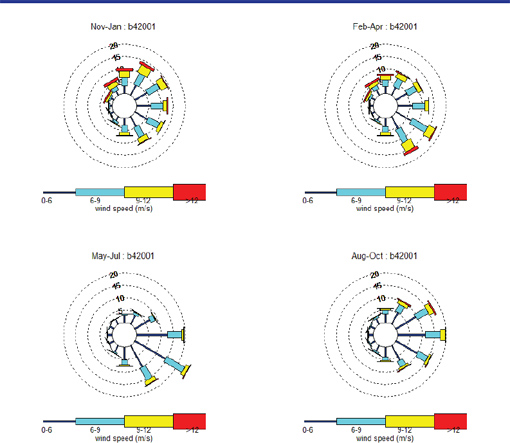
FIGURE 1.2 Seasonal wind roses for NDBC Buoy 42001 located roughly in the center of the Gulf. The dotted circles indicate the percent time of occurrence while the colors indicate the speed bin.
SOURCE: Image created by committee using data from NOAA’s National Data Buoy Center, station 42001 (http://www.ndbc.noaa.gov/station_page.php?station=42001).
the Gulf tends to be relatively warm and humid, it is a primary source of moisture for rain over approximately half of the continental United States (Vachon et al., 2010).
Physical Oceanography
The GoM is the largest and northernmost series of basins forming the Gulf-Caribbean complex (see Figure 1.1). Semi-isolated on the western
periphery of the Atlantic, the pelagic components of the complex are very closely linked to the larger ocean by the intensified western boundary current of the North Atlantic gyre. Surface waters of this current flow through the shallow gaps between Caribbean islands and enter the Gulf through the Yucatan Strait, exiting through the Florida Strait. Deep flow is less well understood within the two deep channels connecting the Caribbean to the Atlantic. The multiple types of ocean currents in the Gulf have been analyzed and summarized in the literature, including a Gulf-wide summary by Wiseman and Sturges (1999); a thorough analysis and synthesis of historical data in deepwater by Nowlin et al. (2000); and a more recent anthology of papers on Gulf circulation, most focused on deepwater, by Sturgis and Lugo-Fernandez (2005), with one paper in the anthology specifically summarizing the state of knowledge (Schmitz et al., 2005).
Deepwater Circulation
In the east-central Gulf, ocean currents in the upper 1,000 m of the water column are often dominated by the Loop Current, a warm ocean current that eventually joins the Gulf Stream (Figure 1.3). The northward extent of the Loop varies by 400 km over the span of roughly a year, at times extending north to the outer shelf of Louisiana, Mississippi, Alabama, and the Florida Panhandle. During this northward extension, the Loop “pinches” west of Key West and forms an eddy (henceforth referred to as an “LCE,” Loop Current Eddy) of 150-400 km in diameter. Eventually the LCE migrates to the west at about 2-5 km d–1. After a journey of several months it collides with the western Gulf shelf where it slowly decays over the course of a year. Horizontally, the currents in an LCE vary nearly linearly from a peak of 1-2 m s–1 at the outer edge to near zero at the center. Below 75 m depth, the currents decay exponentially and are minimal by 1,000 m (Cooper et al., 1990).
The Loop Current and LCE serve as important transport mechanisms in the Gulf, bringing in approximately 28 × 106 m3 s–1 of relatively warm, salty Caribbean waters. While attached to the Florida Current, most of this water exits a week or so later through the Florida Strait, after the Loop has entrained some indigenous Gulf water and diffused some of its own salty warm water into the Gulf. The more significant transport occurs when an LCE separates and later unravels in the western Gulf. Both mechanisms work to transport pollutants and shelf waters, including freshwater runoff with its constituents (sediment, nutrients, pollutants, and organic carbon) from the major Gulf rivers.
In addition to the LCEs, the Gulf is teeming with mesoscale eddies
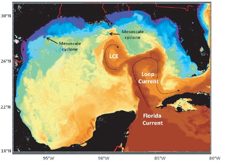
FIGURE 1.3 Infrared satellite image showing major surface currents in the Gulf (LCE = Loop Current Eddy). Red colors indicate warm water while blue colors indicate cold water.
SOURCE: Copyright © 2011 The Johns Hopkins University Applied Physics Laboratory. All Rights Reserved.
(cyclones) on the order of 30 km in diameter with peak speeds of 50 cm s–1 (Schmitz et al., 2005; Figure 1.3). Some are generated by the strong shear found along the periphery of the Loop Current and LCE but others form along additional fronts, as demonstrated by the eddy separating colder and fresher shelf and slope waters (Figure 1.3). As with the LCEs, mesoscale eddies have the potential to transport freshwater constituents over distances, although the amount of transport is limited by the smaller size (30 km) and shorter life spans (on the order of one week). Both LCEs and mesoscale eddies are important means of transporting water between the shelf and the deeper Gulf (Schmitz et al., 2005).
Another persistent and energetic deepwater current in the Gulf can be traced to planetary waves, also known as Rossby Waves, which were first documented by Hamilton (1990). These ubiquitous waves have periods on
the order of 14 days and propagate across the deepwater Gulf generating currents on the order of 15 cm s–1 through much of the water column. Within a few kilometers of the Sigsbee Escarpment (Figure 1.1), the sharp topography can trap and substantially intensify these planetary waves, generating currents on the order of 100 cm s–1 near the bottom in 2,000 m of water (Dukhovskoy et al., 2009). Because these waves have long wavelengths, on the order of 100 km, they are also capable of transporting pollutants or other materials some distance over a one-to-two-week period. The oscillatory nature of waves, however, might also cause pollutants to be returned when the current reverses direction. This phenomenon was thought to be the mechanism of transport for the large deepwater plume of oil from the Macondo wellhead (Camilli et al., 2010).
Currents driven by astronomical tides in the deepwater Gulf are weak in amplitude with small spatial changes in phase (Reid and Whitaker, 1981). Typical currents in deepwater are less than 2 cm s–1. Mean wind-driven currents in the deepwater Gulf are not readily discernible although a number of authors conjecture the existence of weak anticyclonic gyres in the western and central Gulf that could be partially driven by large-scale winds (see Schmitz et al., 2005). Despite the weak mean winds, the Gulf is subjected to strong storm winds. During hurricanes, currents on the order of 2 m s–1 can be generated over the mixed layer for a few hours. These storms can also generate inertial currents with periods of approximately 24 hours and oscillations of 50 cm s–1 that reach deep into the water column and persist for several days after storm passage (Brooks, 1983). The storm-driven response during winter storms is much weaker than during hurricanes, reflecting the weaker winds and the deeper mixed layer typical of fall-winter months. Because the currents are primarily oscillatory, inertial currents cannot transport pollutants more than a few tens of kilometers.
There have been few published investigations of the deeper layers of the Gulf with the major exception of DeHaan and Sturges (2005) and Weatherly et al. (2005); the currents they discuss are only a few cm s–1 in strength.
Shelf Circulation
Circulation on the shelf is closely tied to the local topography reflecting the importance of friction in the current dynamics. In general, tidal currents are on the order of 5 cm s–1. Regardless of the location, winds are a factor especially during tropical cyclones or winter storms. The transfer of wind energy through the water column is dramatically affected by stratification induced by solar heating and the substantial freshwater discharge from the
major rivers in the Gulf. When this stratification is strongest, near-bottom currents become uncorrelated with the local winds, although if the winds change rapidly some wind energy penetrates downward via inertial oscillations (Wiseman et al., 2004).
Other significant types of currents vary according to the region as follows:
• The west Florida shelf is discussed in some detail by Weisberg et al. (2005). Wind forcing is dominant over most of the shelf with upwelling in the winter and downwelling in the summer. The Loop Current sets up a large-scale sea-level gradient along the shelf that models suggest can generate substantial southerly currents.
• On the Mississippi-Alabama shelf, the discharge from the Mobile-Tombigbee, Pascagoula, Pearl, and Mississippi rivers are an important influence on near-surface stratification, which in turn affects the transfer of wind through the water column. A mean cyclonic surface circulation has been suggested by Dinnel (1988), although there is no evidence of this circulation in the more recent analysis of DiMarco et al. (2005). On the outer shelf, major intrusions of the Loop Current and LCE occur every few years and can persist for one to two months causing large exchanges between the shelf and slope as summarized by Schmitz et al. (2005).
• On the Louisiana-Texas shelf, the Mississippi and Atchafalaya rivers play a large role in modifying the vertical stratification, which in turn affects the transfer of wind through the water column. The general circulation pattern is a large but weak (on the order of 5 cm s–1 on average) cyclonic cell, though its direction can be reversed during mid-summer in the presence of stronger westerly winds (Cochrane and Kelly, 1986). Upwelling favorable conditions can occur with winds from the north in the summer (Wisemann et al., 2004).
Estuarine Circulation
Numerous estuaries break up the coastline along the northern Gulf. An extensive system of bayous surrounds the Mississippi and Atchafalaya rivers. Currents in these areas are dominated by river discharges and wind. Direct transfer of wind momentum to the lower water column is often constrained by freshwater stratification but, given the close proximity of land, the wind can also set up larger scale pressure gradients that effectively drive flow beneath the mixed layer.
ECOLOGICAL SETTING
Habitat Characterization
Within the context of ecosystem services, habitat provides one description of ecosystem structure. Stated simply, habitat is the place where an organism or a recurrent suite of organisms lives. Given that biotic content is the primary criteria for recognition of habitats, the geospatial task of mapping habitats should be based on the single criterion of a comprehensive biotic inventory, at least conceptually. Unfortunately, such highly detailed surveys are seldom feasible over management-relevant spatial scales and time constraints. Habitat mapping, therefore, proceeds with the use of alternative criteria. Among the numerous alternatives in use, one requires narrowing actual biotic surveys to a few indicator species (e.g., mangrove habitat, fish habitat, brown pelican habitat, red snapper habitat, cold coral habitat, etc.). Habitats can also be delineated on the basis of abiotic factors known to have a strong correlation with a particular suite of species (e.g., low salinity habitat, subtidal habitat, deepwater habitat, etc.). In an attempt to include many types of information in habitat classifications various metrics have been proposed; Diaz et al. (2004) identified 64 separate metrics that have been used or proposed. With such a multitude of criteria, it is easy to understand that Franschetti et al. (2008) found 1,121 European marine habitats, but was able to reduce them to a list of only 94.
Among the marine habitats, coastal ones are the best characterized and delineated. The importance of emergent vegetation, where present, as a structuring component of habitat has led to a long-standing tradition of classification based on plant cover. The strong correlation between plant community and abiotic factors such as inundation, salinity, and substrate allow non-biotic mapping of habitats that are largely consistent with biotic criteria. Beyond the beach and progressing into deeper water, characterizing habitats becomes increasingly tentative. Data for strictly biotic criteria are increasingly hard to gather, and the use of a few “indicator species” probably has minimal ecological relevance. Advancement in acoustic seafloor mapping has resulted in considerable interest in habitat classification using remote and rapid surveys of bathymetric and seafloor characteristics (Kenny et al., 2003; Todd and Greene, 2008). The unfortunate limitation of these approaches lies in the difficulty of determining if a substantial correlation with seafloor biology exists (Diaz et al., 2004; Stevens and Connolly, 2004). The approach may be best applied to bathymetric relief seafloors. It may be far less useful when applied to the far more common mud bottoms like those across much of the GoM (Zajac, 2008).
Even though the continental shelf and slope of the GoM are probably the most extensively surveyed part of the U.S. Exclusive Economic Zone (EEZ), due in large part to the energy industry’s interest in gas and oil extraction from these areas, little use has been made of these largely proprietary data to classify habitats. Two notable exceptions of available bathymetric survey data were used to identify topographic highs and possible hard bottom on the shelf and slope. These were surveys of the Bureau of Ocean Energy Management, Regulation and Enforcement (BOEMRE, formerly Minerals Management Service) for fluid and gas expulsion (Chem III, Roberts et al., 2008) and deepwater Lophelia spp. corals (Lophelia II, project under way). The data produced from these industry-related surveys are online.2 The identified geologic features in both shallow and deep waters provide habitat for protected corals and seep communities. Actual confirmation of the habitat type is based upon direct faunal sampling and imaging of the biota.
In summary, marine habitats are almost never identified and mapped on the basis of a single main criterion. Multiple criteria are applied, producing numerous and often overlapping classifications. While potentially confusing, the reality of nature is that no single factor or even suite of factors consistently controls the biota living across the many gradients encountered in the ocean. One thing is most certain, the more a seemingly homogeneous habitat is studied, the more complex it is shown to be.
Inshore Habitats of the GOM
Inshore habitats of the northern GoM range from uplands through intertidal areas and wetlands to open bodies of water in bays and lagoons sheltered from the open Gulf by barrier island formations or emptied through tidal passes and open connections with Gulf waters. At the interface of upland and open water are numerous types of wetlands that receive periodic or tidally influenced submersion of soils and plants. Classes of wetlands that occur within the GoM are estuarine emergent (e.g., tidal marshes), estuarine shrub-scrub (e.g., mangroves), freshwater emergent (e.g., freshwater marsh or floatant), and freshwater shrub-scrub and forested (e.g., cypress swamps) (Cowardin et al., 1979).
Typical tidal marshes along the northern rim are Spartina patens and Spartina alterniflora marshes; the former are found in upland, brackish conditions less frequently submerged, and the latter form expansive landscapes
_____________
2 See http://www.boemre.gov/offshore/mapping/SeismicWaterBottomAnomalies.htm.
in frequently flooded saline waters. Black needlerush, Juncus romerianus, grows on elevated mud deposits and is usually flooded only during high tide. Sawgrass, Cladium jamaicense, occupies an intermediate marsh zone, preferring lower salinities and more flooding than other marsh species, a good indication of regular freshwater flow. Marshes are interspersed with elevations, hammocks, or cheniers that support coastal forests.
Mangroves (Avicennia germinans) dominate coastal wetlands in tropical and subtropical latitudes and occur primarily in Texas and Florida, but also in Louisiana, Mississippi, and Alabama depending on temperature regimes. Mangroves are sensitive to cold temperatures and tend to be smaller in the northern part of their range. Severe freezes that typically occur in 10-year cycles kill back mangroves, which can take 5-10 years to reestablish. In the meantime, the mangroves are replaced by smooth cordgrass (Spartina alterniflora) until the mangroves recover. Along the most northern coasts of the GoM, Spartina alterniflora marshes compete with mangroves for domination of the saltier parts of the system.
The marsh is dotted with treed islands of coastal forest, commonly called hammocks. These hammocks have little tolerance for salt and grow only where the elevation is high enough to prevent flooding during high tides. The most common tree species on a coastal hammock are sabal palm (Sabal palmetto), red cedar (Juniperus silicicola), pine (Pinus elliottii), and live oak (Quercus virginiana).
Mud or sand tidal flats form above the mean high water, just beyond the reach of the highest tides in the high marsh. Only occasional storm-driven high tides flood the tidal flats. Salts accumulate because there is not enough flushing to wash them away and only the most salt-tolerant plants such as pickleweed and glassworts grow in a tidal flat.
Open water areas of the northern GoM are usually in the form of lagoons and bays. The formation of different habitats depends on substrate type (mud to sand) and depth. Open bay and estuarine waters are soft-bottom habitats that usually lack visible vegetation. In shallower intertidal muddy areas, oyster reefs develop along tidal creeks and open water where the tidal setting is low-energy with adequate but not excessive freshwater flow from surface runoff or river input. Oyster reefs are bioherms; they form a biologically based substrate for use by other organisms. In sandier protected bay and lagoon settings, submerged seagrass meadows are common where water clarity is suitable for their growth. Common sea grasses in the northern Gulf are turtle grass (Thalassia testidinum), shoal grass (Halodule wrightii), manatee grass (Syringodium filiforme), widgeon grass (Ruppia maritima), and star grass (Halophila engelmannii).
Coastal habitats provide a wide range of ecosystem services, including support for fishery production, water quality improvement, nutrient cycling, wildlife habitat provision, recreational opportunities, storm surge protection, carbon sequestration, and social support of coastal-based economies, such as oyster harvesting, tourism (specifically ecotourism), resource extraction, and water-borne transportation. These coastal habitats provide shelter and food resources for fishes, crustaceans, and shellfish.
Wetlands are widely recognized for their capacity to remove nutrients and pollutants from overlying waters, in effect improving water quality, recycling reactive nitrogen to N2 gas and reducing the potential for eutrophication, defined as the increase in the rate of primary production and accumulation of resulting organic carbon in an aquatic system (modified Rabalais, 2004 and Nixon, 1995). Eutrophication is manifested as turbid waters, growth of filamentous algae on seagrass blades, noxious and harmful algal blooms, and oxygen depletion (as microbes decompose the accumulating carbon). The removal of nitrogen depends on the type of wetland, the concentration of nitrogen entering the wetland, the water residence time, and the acreage available for the denitrification process.
Offshore Habitats
Offshore habitats of the northern GoM start at the low-tide level on coastal shores and extend to the Sigsbee abyssal plain with a maximum depth > 3,800 m. About 40 percent of the area is covered by vertically mixed shelf water that is influenced by freshwater inflows of the 20 large river systems draining into the coast. The break between continental shelf and slope varies around the circumference of the Gulf. In general it begins between 100 and 150 m giving the shelf a width ranging from 90 km off southern Texas to 220 km off Florida. Unusually narrow 12 km and 32 km shelves are encountered off the mouth of the Mississippi River and at the head of Desoto Canyon. The substrate is predominantly near-shore sands grading seaward to silt and mud. There is a related transition in the species composition of bottom fauna. Shelf populations of the shrimp Litopenaeus setiferus and Far-fantepenaeus aztecus support a major commercial fishery. Fish such as red snapper (Lutjanus campechanus) support both commercial and recreational fisheries. The shelf contains essential habitat for estuarine-dependent species with life histories that include an estuary-to-ocean migration.
The periphery of the Gulf of Mexico is characterized by a remarkable diversity of hard-bottom features rising from the seafloor and forming a series of elevated bathymetric features. Some of these features are ancient
shorelines, others former seabeds thrust up by salt movement. Still others originate from ancient coral reef growth. These hard banks support diverse communities of tropical and subtropical plants, invertebrates, and fishes and are considered to be sensitive habitats. The structures that rise a few meters above the surrounding seafloor, such as a series of shoals off the Atchafalaya River delta, provide refugia from seasonal bottom-water hypoxia on the northern Gulf of Mexico. Middle and outer shelf hard-bottom structures are mostly drowned reefs, or are associated with salt domes and outcrops of limestone, sandstone, claystone, and siltstone with a variety of soft coral, sponge, and macroalgae. These banks are considered to be critical spawning habitat for many commercially important species of groupers and snappers. Banks reaching to the euphotic zone and supporting coral reefs are few in the northernmost Gulf (East and West Flower Garden Banks) but become increasingly abundant on the central and southern Florida coast (Pulley Ridge and Tortugas Bank). The coral framework is dominated by Montastrea annulari, Montastrea cavernosa, Diploria strigosa, and Porites astreoides. Like coral reefs everywhere, the Gulf reefs are biodiversity hotspots with strong aesthetic appeal that support fisheries, biological prospecting, and recreational uses. Some of these high-diversity habitats can be found within one of the designated areas of the National Marine Sanctuary Program, or are listed as a Habitat of Particular Concern by BOEMRE for restricted activities.
Offshore from the edge of the shelf, two oceanographic features previously described impact the habitats of the deep basin: the Loop Current that brings Caribbean waters into the Gulf from its southwestern boundary of the Yucatan Strait and the anticyclonic cell circulation along the western side. These two features are distinct because of seasonal differences in the depth of their thermoclines (Cochrane, 1972) that create conditions for different marine community composition. In the northern GoM, the continental slope is atypically diverse due to the unusual combination of geological processes described earlier. The complex geomorphologies of the sediment slope and its basins and ridges have diverse fauna with typical depth-related declines in biomass and species, replacement deposits, and an overall maximum species richness that occurs at mid-slope depths. Fishes and crabs decrease in diversity with depth, while echinoderms and sediment-dwelling worms increase. The biological communities of the vast mud bottoms are the last consumers of organic carbon before the residual carbon becomes buried. Fisheries exploitation of deepwater is minimal, but specialized trawl fisheries exist for royal red shrimp (Hymenoenaeus robustus), rock shrimp (Sicyonia brevirostris), and calico scallop (Agropecten gibbus).
Surface-water habitats such as Sargassum mats (Wells and Rooker, 2004)
and water column communities are influenced by a number of important oceanographic variables, including
1. dissolved oxygen levels (Prince and Goodyear, 2006),
2. the location of the thermocline (Bigelow and Maunder, 2007),
3. light levels (Dewar et al., 2011), and
4. the presence of oceanic fronts in the edges of the Loop Current and ocean eddies (Kleisner et al., 2007).
The thermocline can be a boundary for many epipelagic (upper water) organisms. Mesopelagic organisms occupy the waters below this boundary, while photosynthetic organisms are absent in the bathypelagic zone which is almost completely absent of light. Most organisms remain within their respective zones, but some migrate between the epipelagic and mesopelagic in search of prey, for example swordfish (Xiphias gladius) (Dewar et al., 2011) and blue marlin (Makaira nigicans) (Kraus and Rooker, 2007). Other organisms such as zooplankton and sperm whales (Physeter macrocephalus) may migrate over the full depth of the water column. The vertical zones extend over smaller or larger horizontal scales for epipelagic and mesopelagic fish (Kleisner et al., 2010). While the deep seafloor has traditionally been considered an ecological sink receiving food from shallower water but contributing little in the upward direction, this view is changing (Tenore et al., 2006). Many deep-sea animals produce eggs and larvae that develop among surface water food webs and participate in shallow water food webs. Zooplankton serve as conveyors of carbon from the surface to greater depths. Sperm whales forage at great depths (Amano and Yoshioka, 2003), but must return to the surface to breath. Throughout the water column and deep seafloor, microbes are contributing to the larger marine ecosystem by returning nutrients through their metabolic functions.
The deep slope contains special habitats associated with the geochemistry of upward migrating salt, seeping hydrocarbons, and the precipitation of calcium carbonate (Roberts and Carney, 1997). Active sites are associated with chemosynthetic communities dominated by bathymodiolid mussels and vestimentiferan tubeworms; species composition changes with depth in a manner similar to mud-bottom species. Carbonate features with minimal to no seepage support a diverse fauna of sessile and rock boring fauna. Unique chemosynthetic and deep coral communities, such as Lophelia pertussa, are biodiversity “hotspots” that receive regulatory protection from offshore drilling. They are widely appreciated as natural systems and iconic species of the deepwater GoM ecosystems.
Food Webs and Trophic Interactions
While the GoM’s physical habitats provide ecosystem boundaries, their components link through complex trophic interactions. A food web is formed by linkages between multiple organisms in a complex feeding hierarchy that changes in time and in response to external factors (Pimm et al., 1991). The number of links in the food chain that one organism is removed from another describes the organism’s trophic level. There are rarely more than four or five levels (primary producers, herbivores, omnivores, and carnivores) in a food web, because only a fraction (10-20 percent) of the energy at each level can be incorporated by the next level up. However, the organization within each level and interactions among the levels may be more complex than previously thought (Allen and Fulton, 2010; Montagnes et al., 2010). Each species in an ecosystem is affected by other organisms, interactions between trophic levels, and the environment. There are few single prey-single predator relationships, such that if one species is removed from an ecosystem, several other species will be affected. Multi-level trophic interactions may be more reflective of changes in trophic structure and potential ecosystem services than the presence, absence, or relative abundance of a species. Changes in trophic levels of global and regional catches are considered by the Food and Agriculture Organization (2002) as a better reflection of trends in fisheries than the proportion of fish stocks that are reported as depleted, overexploited, fully exploited, and moderately exploited (Food and Agriculture Organization, 2002). On the other hand, trophic level metrics, such as mean trophic level, were not found to be useful indicators of marine biodiversity and ecosystem status, particularly fisheries status, because the metrics are influenced by changes in economics, management, fishing technology, and targeting patterns (Branch et al., 2010).
Biodiversity
Biodiversity is the degree of variation of life forms within an ecosystem or biome. It is often a good measure of the health of an ecosystem. Biodiversity contributes to the stability of ecosystems, due to the diversity of functional responses of community members to perturbation. From the point of view of an individual organism, the ability to recover from a disturbance can vary with different life history characteristics. For example, when an organism can exploit a wide range of resources (as a generalist), a decrease in biodiversity is often less likely to impact that organism. However, an organism that can exploit only a limited range of resources (a specialist) is more likely to be affected by a decrease in biodiversity. Biodiversity in the
GoM, as elsewhere, is threatened by a number of factors including overexploitation of living resources, reduced water quality, coastal development, shipping, invasive species, factors associated with global climate change, the expansion of hypoxic and anoxic zones, and increases in harmful algal blooms (Fautin et al., 2010). Trophic structure and the complex dynamics of trophic level interactions affect the rate at which a population will recover from a negative impact.
Felder and Camp (2009) conducted the most recent, comprehensive biodiversity survey of the Gulf. The high diversity of marine life that exists in the Gulf makes it one of the most biodiverse oceanic water bodies on the planet (Fautin et al., 2010). Unfortunately, detailed studies of biodiversity in the GoM have been limited to a few well-studied regions including the northwestern Gulf oil and gas region, the Florida Keys, and areas of known high biodiversity like oyster reefs and seagrass beds. The effects of preserving diversity can be broadly beneficial to a wide spectrum of important ecosystem services, including fisheries, water quality, recreation, and shoreline protection. Conserving diversity increases the likelihood that ecosystems can adapt and recover following disturbances from natural or anthropogenic causes (Palumbi et al., 2009). Plant and animal species of interest—including keystone (organisms that play an influential role in maintaining ecosystem structure), indicator (species that indicate the presence of certain environmental conditions), commercially important, and endangered species of the GoM—are highlighted in Table 1.1.
Microbial Diversity
Biodiversity takes on a different meaning when applied to the two microbial domains of life, the Bacteria and the Archaea (single-celled organisms that lack a nucleus). Microbes dominate the global ocean, both in terms of numerical abundance (averaging 106 per milliliter of seawater for an estimated total of 1030 in the global water column) and of biomass, up to 90 percent of the total (Fuhrman et al., 1989; Whitman et al., 1998). Microbial biodiversity exceeds all plants and animals combined. Using state-of-the-art, high-throughput DNA sequencing during the recently completed Census of Marine Life, researchers discovered that the ocean contains, at a minimum, many millions of species of Bacteria and Archaea (20,000 in a single liter; Amaral-Zettler et al., 2010). Although the Census of Marine Life was an extensive global endeavor, only a single location in the GoM (Mississippi Canyon 118 on the Louisiana continental slope at 900 m depth) was surveyed for microbes and results are not yet published. In general, the
TABLE 1.1 Species of Interest in the GoM Large Marine Ecosystem
|
|
||
|
Name |
Species |
Significance |
|
|
||
|
Kemp’s Ridley sea turtle |
Lepidochelys kempii |
most endangered marine turtle in the world; keystone species |
|
Whooping crane |
Grus americana |
endangered |
|
West Indian manatee |
Trichechus manatus ssp. latirostris |
endangered; |
|
Menhaden |
Brevoortia patronus |
largest commercial fishery by weight |
|
Penaeid shrimp |
Litopenaeus setiferus (white), |
highest monetary value commercial fishery |
|
Grouper and snapper |
various |
offshore commercially and recreationally important |
|
Atlantic croaker |
Micropogonias undulatus |
indicator species |
|
American oyster |
Crassostrea virginica |
commercial coastal fishery; |
|
Blue crab |
Callinectes sapidus |
commercial coastal fishery |
|
Spiny lobster |
Panulirus argus |
southern Gulf commercial fishery |
|
Pink conch |
Eustrombus gigas |
regulated recreational fishery |
|
Spotted sea trout |
Cynoscion nebulosus |
northern Gulf recreational fishery |
|
Red drum |
Sciaenops ocellatus |
northern Gulf recreational fishery |
|
Red snapper |
Lutjanus campecheanus |
northwestern Gulf recreational fishery |
|
Bottlenose dolphin |
Tursiops truncatus |
well known by public; keystone species |
|
American alligator |
Alligator mississippiensis |
keystone species |
|
American crocodile |
Crocodylus acutus |
keystone species |
|
Smooth cordgrass |
Spartina alterniflora |
keystone species |
|
Saltmeadow cordgrass |
Spartina patens |
keystone species |
|
Common reed |
Phragmites australis |
indicator species |
|
Maidencane |
Panicum hemitomon |
indicator species |
SOURCE: Derived from Fautin et al., 2010.
widespread occurrence of marine microbes, their ability to reproduce rapidly when conditions allow, and the functional redundancy built into their communities mean that environmental changes and anthropogenic impacts do not imperil the existence of specific groups, such as those that recycle nutrients, degrade hydrocarbons, or provide chemosynthetically derived food for higher organisms at hydrocarbon seeps. Instead, altered environmental conditions favor the reproduction and actions of those microbes best suited
to prevailing conditions. A case in point is the DWH plume that stimulated the growth of deep-sea indigenous γ-proteobacteria that are closely related to known petroleum degraders (Hazen et al., 2010).
Human Interactions and Coastal Communities
There is a wide range of human communities affected by and interacting with various components of the GoM ecosystem, depending on what assumptions are made regarding boundaries and scope of interaction. For example, consumers worldwide who eat seafood harvested from the GoM are ultimately affected by the availability and quality of commercial fish and shellfish stocks in the Gulf. Groups outside the region, however, often have alternatives for purchasing fish from other U.S. regions and internationally. Obtaining seafood from other sources threatens businesses around the Gulf region. People living in or near the GoM system may rely on specific Gulf resources which cannot be easily substituted.
Coastal U.S. counties in the GoM include 142 jurisdictions, as defined by the Strategic Environmental Assessments Division of the National Oceanic and Atmospheric Administration (NOAA). Wilson and Fischetti (2010) suggest an environmentally based approach for classifying coastal counties to understand the interplay between human activities and water and habitat quality along the coast, and include a greater area than simply the group of counties that physically border the water. To be considered a coastal county in the NOAA system, a county must meet at least one of the following criteria: “1) at least 15 percent of a county’s total land area is located within the Nation’s coastal watershed; or 2) a portion of or an entire county accounts for at least 15 percent of a coastal cataloguing unit.”3
U.S. GoM coastal counties comprise 115,000 square miles of land area (Bureau of the Census Statistical Abstract4), with 20.4 million residents, reflecting 7 percent of the overall U.S. population as of July 1, 2009. Residents in these counties occupied 9,144,000 housing units; and in 2008, 463,000 non-farm business establishments employed 7,028,000 non-farm employees. Employment in coastal counties comprises about 18 percent of all employment in the Gulf Coast states, although the proportion ranges as high as 34 percent in Louisiana and 31 percent in Florida (Adams et al., 2004).
Major occupations in the northern Gulf of Mexico region as reported in 2010 include oil and gas drilling, water transportation-related industries, and leisure and hospitality, the latter particularly related to gaming and ca-
_____________
3 See http://www.census.gov/geo/landview/lv6help/coastal_cty.pdf.
4 See http://www.census.gov/compendia/statab/2011/tables/11s0026.pdf.
sinos but also including other types of recreation (Bureau of Labor Statistics, U.S. Department of Labor5). Tourism continues to be a key driver of coastal economic and property development (Yoskowitz, 2009).
Commercial fishing is prominent in the Gulf economy, with commercial fisheries landings accounting for about 25 percent of all U.S. seafood landings and about 21 percent of the total U.S. dockside fisheries value (Adams et al., 2004). The Gulf fishery is characterized by a diverse fleet of vessels harvesting from open water to near shore, including nearly 25,000 commercial fishing craft representing close to one-third of the entire U.S. commercial fishing fleet (Adams et al., 2004). In 2008, 165 processing plants and 229 wholesale plants employed nearly 10,000 workers that supported the commercial fishery.6 In addition, the recreational fishing industry supports employment in coastal counties (Adams et al., 2004).
GoM Fisheries
The diversity of fishery species in the GoM is listed in the fishery management plans of the GoM Fishery Management Council (GoM FMC, 2010). The species list includes 3 mackerels, 14 snappers, 15 groupers, 5 tilefish, 4 jacks, 2 sand perches, 1 gray triggerfish, 1 hogfish, 4 shrimp, 2 lobsters, and 2 stone crabs. There are other important species that occur in the GoM that are managed under the highly migratory species fishery management plan (NOAA, 2004). These include 8 species of tuna, 6 billfish, and 72 species of sharks. This accounting does not include all harvested species because many of lesser economic importance are not listed individually in the plans, for example, dolphinfish, a species recognized to be part of the coastal migratory pelagic fishery but not part of the managed units. There are also important fishery species exclusively managed by coastal states, including some commercially important estuarine species (e.g., sea trout and mullet) and those reserved for recreational use, such as snook, tarpon, and bonefish.
Aquaculture
The GoM FMC manages offshore aquaculture operations in federal waters of the Gulf. Although at present there are few aquaculture operations in federal waters the potential use area is large and ranges throughout the Gulf (Figure 1.4; GoM FMC, 2009).
_____________
5 See http://www.bls.gov/oes/highlight_gulf.htm.
6 See http://www.st.nmfs.noaa.gov/st1/fus/fus09/10_industrial2009.pdf.
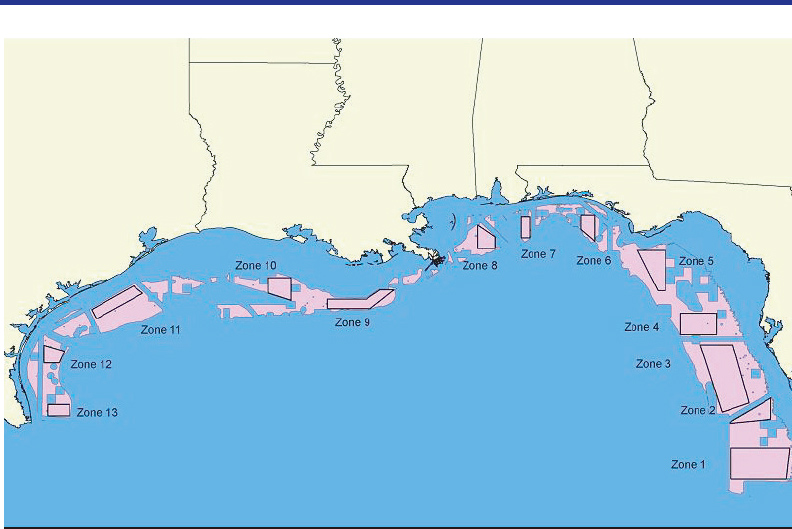
FIGURE 1.4 Potential for offshore aquaculture in the GoM. Pink represents all areas considered suitable for aquaculture in the Gulf EEZ (28,719 nm2). Zones 1–13 (10,392 nm2) are preferred zones under the GoM FMC aquaculture plan.
SOURCE: GoM FMC, 2009.
SUMMARY
This chapter presents an overview of the remarkably complex geological, meteorological, oceanographic, and biological processes, a variety of habitats, and complex ecological and human interactions at work in the Gulf.
Geological processes working over millennia set the stage in the GoM, creating a region of high productivity and accumulation of abundant hydrocarbon resources. In the northern GoM, the Mississippi River shaped, and continues to shape, the coastal areas with sediment-rich waters continuously reforming the landscape into the Mississippi and Atchafalaya river deltas. The Gulf’s oceanic environment is largely determined by wind and currents, which respectively establish the regional weather patterns and serve as an important transit system for pollutants and runoff throughout Gulf waters. The region is also characterized by diverse ecological habitats, ranging from highly produc-
tive, vegetated intertidal zones and wetlands along the shore to less productive benthic and pelagic habitats of the open waters. These habitats provide the setting for the Gulf’s prolific biodiversity—plants, animals, and microorganisms—whose maintenance is essential to healthy and stable ecosystems.
The GoM is a rich environment with abundant natural resources, diverse habitats, and biodiversity. Many human communities live in the region and rely on the various ecosystem services for their economic livelihood. In addition to the estimated 20.4 million residents, the Gulf of Mexico is home to oil and gas production, commercial fisheries, transportation, and recreational industries. The GoM is highly productive in both renewable and non-renewable resources. Fisheries and tourism have long co-existed with the petrochemical industry along much of the Gulf of Mexico shoreline, with the exception of Florida.
Renewable and living resources and the food webs and habitats that support them were exposed to varying levels of toxicity and exposure to oil and natural gas from the Macondo well. The effects of the oiling are currently being assessed in many habitats, across complex food webs, with regard to short- and long-term impacts, as altered biogeochemical cycling, and in relationship to ecosystem functioning. Some GoM ecosystems and processes are well known, but knowledge in many cases may be sparse. This uneven understanding of the ecosystem and processes is not uncommon but creates uncertainty that has to be acknowledged as data and findings are synthesized. The ability to detect impacts of the oil spill by way of the health of organisms or the level of ecosystem functioning will require adequate data and multiple lines of evidence of altered ecosystem processes. Failure to recognize essential factors or processes within (and between) ecosystems of the Gulf region may result in improper characterization or in misrepresentation of the full range of ecosystem functions that support ecosystem services.
Finding 1.1: The Gulf of Mexico comprises a large, complex ecosystem that has been and continues to be subject to both natural and human forces of change. Hence, the baselines against which the impact of the spill can be assessed are both spatially and temporally dynamic.
This page intentionally left blank.


