
The BDCP has been developed in an environment characterized by complexity and uncertainty. Furthermore, the BDCP context is dynamic, with underlying conditions themselves in flux. Complexity and uncertainty characterize the biophysical environment, including complexities and changes in the hydrologic system, such as interactions of altered freshwater discharge regimes of tidal influences, changes in the composition and numbers of many species, variability and changes in precipitation, nutrient and sediment input, and changes in the built environment. They also characterize the human environment, particularly with regard to population growth; people’s livelihoods and lifestyles; political, financial, and economic conditions; changes in technology; and changes in people’s understanding of these systems. Uncertainty is inherent in many of the above factors. The panel did not consider all of the above factors during its review because to do so would be difficult, time-consuming, and beyond the panel’s charge. Nevertheless, recognition of the difficult environment in which the BDCP is being developed is helpful in gaining an understanding and appreciation of the difficulties surrounding it and other attempts to improve the reliability of water supplies in California and to restore the Delta ecosystem. The panel thus briefly summarizes the history and the human and biophysical environment of the region.
The San Francisco Bay Delta Estuary (Delta, for short) includes the lower reaches of the two most important rivers in California and the eastern estuary and associated waters of San Francisco Bay. The Sacramento and San Joaquin Rivers and their tributaries include all of the watersheds that drain to and from the great Central Valley of California’s interior, as shown in Figure 2. The respective deltas of these rivers merge into a joint delta at the eastern margins of the San Francisco Bay estuary. The Delta proper is a maze of canals and waterways flowing around more than 60 islands that are protected by levees. The islands themselves were historically reclaimed from marshlands as agricultural lands, and most of them are still farmed.
Today, the Delta is among the most modified deltaic systems in the world (Kelley,1989; Lund et al., 2010). The Sacramento-San Joaquin Delta, as shown in Figure 3, is an integral part of the water supply delivery system of California. Millions of acres of arid and semi-arid farm lands depend upon the Delta for supplies of irrigation water, and approximately 25 million Californians depend upon transport of water through the Delta for their urban water supplies. Population growth anticipated for the first half of the 21st century is likely to create additional water demands despite significant reductions in per capita consump-
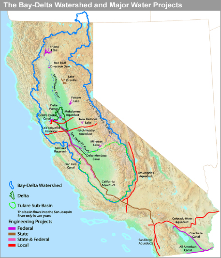
FIGURE 2. The Bay Delta Watershed. SOURCE: Reprinted, with permission, from National Resources Defense Council (http://www.nrdc.org).
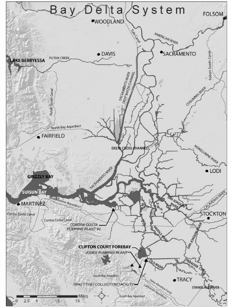
FIGURE 3. The Sacramento‐San Joaquin Delta in California. San Francisco Bay, an integral part of the system, is just to the west. SOURCE: Reproduced from NRC (2010b), modified from FWS (2008).
tive uses. In addition, the Delta provides habitat for fish and wildlife, some species of which are listed as threatened or endangered under the federal Endangered Species Act and the California Endangered Species Act. The Delta is also an important recreational resource supporting significant boating and fishing activities.
Unimpaired inflows of water to the Delta originate in the watersheds of the Sacramento and San Joaquin Rivers. In an average year those flows are estimated to be 40.3 million acre feet (MAF) or 48.8% of California’s average annual total water resource of approximately 82.5 MAF. Of the total unimpaired average inflow, 11.4 MAF are diverted upstream of the Delta for agricultural (83.8%), urban (15.0%), and environmental (1.2%) uses. Diversions from the Delta itself average 6.35 MAF, a little more than a third of all diversions in the Sacramento-San Joaquin system. Diversions from the Delta are dominated by exports to the irrigation service areas of the federal Central Valley Project (CVP) and the State Water Project (SWP) service areas, which include southern portions of the San Francisco Bay Area, the western side of the San Joaquin Valley, and much of southern California. Significant amounts of water are diverted to irrigate Delta lands, and irrigation return flow is discharged into Delta channels. The average yearly outflow from the Delta remaining after the diversions equals 22.55 MAF (Lund et al., 2010).
The quantities of water reported above are for an average year, but hardly any year in California is an “average” water year. Moreover, averages mask the fact that water supplies are highly variable from one year to another. Thus, for example, in the Merced River, which drains the watershed including most of Yosemite National Park and is a tributary of the San Joaquin River, the average annual flow is 1.0 MAF. Yet the low flow of record for the Merced River is 150,000 acre feet, only 15% of the average flow, while the high flow of record is 2.8 MAF, 280% of the average flow. The variability in flows, which is characteristic of all of the state’s rivers, is largely a function of the interannual patterns of California’s Mediterranean climate, which has a wet and a dry season with precipitation falling mainly in the late fall and winter months. In addition, there is considerable variability in the proportion of the precipitation that falls in the mountains as snow, which adds to the variability of the hydrologic regime.
Until recently, planning for water shortage was based on a five-year dry cycle from the 1930s, or on 1977, the driest year of record. However, recent analyses of potential precipitation resulting from different anticipated climate conditions have changed the criteria employed by the state to project water availability. Despite statewide conservation efforts, which are particularly pronounced in the urban sector, increasing restrictions on diversions have reduced the amount of water available for delivery under the terms of SWP and CVP water supply contracts. These projects, which export water to regions of the state that have experienced persistent water scarcity for many decades, are particularly important features of the California waterscape.
The CVP withdraws water from the Delta and conveys it southward into the San Joaquin Valley through a system of canals built and operated by the federal
Bureau of Reclamation and various water user groups. Most of this water is used for agricultural purposes throughout the San Joaquin Valley and the Tulare sub-basin at the southern end of the Valley. A minor amount is contracted for domestic use. The SWP withdraws water separately from the Delta and conveys it southward to agricultural users on the west side and at the very southern end of the San Joaquin Valley and subsequently over the Tehachapi Mountains into the conurbation of the South Coast Basin. Los Angeles and San Diego are among the water users in the South Coast Basin. The SWP supplies domestic water users in southern California (and a minor amount of domestic use in the southern San Francisco Bay Area) as well as Central Valley agriculture in proportions that are determined in any given year by climatic factors and the availability of alternative sources of supply. Total available supplies have been constrained in recent years by drought and court decisions.
Changes in the hydrologic and physical integrity of the Delta would constrain and threaten the ability of state and federal water managers to continue exporting water in accustomed quantities through the two major projects. This is a concern because the structure of the Delta is changing and will continue to change. Lund et al. (2010) identify several factors that today pose significant threats to the Delta, including: (1) continued subsidence of the agricultural lands on the Delta islands; (2) changing inflows of water to the Delta, which appear to increase flow variability and may skew flows more in the direction of earlier times in the water year in the future; (3) sea level rise that has been occurring over the past 6,000 years and is expected to accelerate in the future; and (4) earthquakes, which threaten the physical integrity of the entire Delta system. There is a long history of efforts to solve these physical problems as well as persistent problems of flood control and water quality (salinity). Salinity intrusion from San Francisco Bay now requires a specific allocation of Delta inflows to repel salinity and to maintain low salinity water at the Delta’s western margin. This is done by monitoring and managing the average position of the contour line identifying acceptable levels of salinity, known as “X2”. Controlling salinity requires outflow releases from reservoirs that could be used for other demands.
Resolution of these problems is complicated by water scarcity generally and because alternative solutions impose differing degrees of scarcity on different groups of stakeholders. Additional allocation problems arise from a complex system of public and private water rights and contractual obligations to deliver water from the federal CVP and California’s SWP. Some of these rights and obligations conflict, and in most years there is insufficient water to support all of them. This underscores the inadequacy of Delta water supplies to meet demands for various consumptive and instream uses as they continue to grow. Surplus water to support any new use or shortfalls in existing uses are unavailable, and any change in the Delta’s hydrologic, ecological, or physical elements could reduce supplies further. The risks of change, which could be manifested either by increases in the already substantial intra-seasonal and intra-annual variability or through an absolute reduction in available supplies, underscore the existence
of water scarcity and illustrate ways in which such scarcity could be intensified.
In its natural state, the Delta was a highly variable environment. The volume of water inflows changed dramatically from season to season and from year to year. Water quality also varied. In wet periods both salinity and chemical inputs (naturally occurring) were diluted. The species that occupied Delta habitats historically were adapted to accommodate variability in flow, quality, and all of the various factors that they help determine. The history of human development of the Delta, both of land use and water development, is a history of attempts to constrain this environmental variability, to reduce environmental uncertainty and to make the Delta landscape more suitable for farming and as a source of reliable water supplies. A full understanding of the historical pervasiveness and persistence of environmental variability underscores the need to employ adaptive management in devising future management regimes for the Delta (Healey et al., 2008).
The history of water development and conflict in California focuses in part on the Sacramento-San Joaquin Delta. Beginning with the California gold rush in 1848, early settlers sought to hold back the seasonal influx of water and to create agricultural lands. The construction of levees played a central role in this effort, which was threatened in the late 1800s and early 1900s by the movement of hundreds of millions of cubic yards of debris from upstream hydraulic mining that passed through the Delta. There followed throughout the first third of the 1900s further work that helped to stabilize a thriving Delta agriculture (Jackson and Patterson, 1977; Kelley, 1989). The CVP, which began operations in the 1940s (Thompson, 1957), and the SWP of the1960s required conveyance of water from mainstream river channels through the channels and sloughs of the Delta to the extraction points located in the southern Delta from where water is pumped into the Delta-Mendota Canal (CVP) and the California Aqueduct (SWP) for transport south as illustrated in Figure 4. Once these projects became operational there was a need to control salinity, which became an issue that was decided by the courts (Hundley, 2001; Lund et al., 2010).
Since the beginning of CVP operations, diversions of water to users outside the Delta have been limited to ensure that salinity intrusion does not adversely affect local domestic water diverters in the western margins of the Delta. Additionally, the California’s constitution requires that the waters of the state be put to “beneficial use,” and this criterion is subject to judicial review and determination. The importance of environmental uses of water has been reflected in many state regulatory decisions and, more recently, in judicial interpretations of the federal Endangered Species Act and the California Endangered Species Act. Several species of Delta fishes and anadromous fishes that migrated through the Delta have been listed as threatened and endangered. The courts became involved, and specific operational restrictions followed from their findings. The maze of federal and state laws as well as the interests of dozens of stakeholder groups have combined to create a gridlock, which at times appeared penetrable
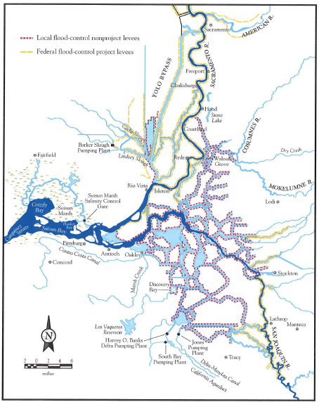
FIGURE 4. The Sacramento‐San Joaquin Delta in California, highlighting the Delta levees, 2006. San Francisco Bay, an integral part of the system, is just to the west. SOURCE: Reprinted, with permission, from Lund et al. (2010). Copyright by Public Policy Institute of California.
only by the state and federal courts (Lund et al., 2010). As a result, most recent water operations have tended to be based on legislative requirements and judicial decisions mandating the protection of individual species rather than the optimization of water allocation among all purposes.
There have been several efforts to resolve differences, find areas of agreement, and identify solutions to the problems of the Delta and the operation and allocation of the waters that flow through it. These efforts assumed particular urgency as California was beset by severe droughts in the periods 1987-1992 and again in the first decade of the 2000s. A collaboration of 25 state and federal agencies called the CALFED program was created in 1994 with the mission “to improve California’s water supply and the ecological health of the San Francisco Bay/Sacramento-San Joaquin River Delta” (http://calwater.ca.gov/calfed/about/index.html). State and federal agencies quickly developed a proposal for water quality standards titled Principles for Agreement on Bay-Delta Standards between the State of California and the Federal Government, otherwise known as the Bay Delta Accord. State and federal agencies with responsibilities in the Delta and stakeholders engaged in a decade-long CALFED process, but they did not alter the strategy of relying on the Delta to convey crucial elements of the water supply to California. The CALFED process also would be used to attain the four main goals of water supply reliability, water quality, ecosystem restoration, and enhancing the reliability of the Delta levees (CALFED, 2000).
The Bay-Delta Accord, which was signed in 2000, began to unravel mid-decade as environmentalists and water users came to believe that their interests were not being well served (Lund et al., 2010) and as federal resources declined. There followed an attempt by the governor to develop a Delta Vision Strategic Plan or “Delta Vision” with the aid of an independent Blue Ribbon Task Force. The Delta Stewardship Plan, which is referred to in this report as the Delta Plan, resulted from this effort. The Delta Plan is a broad umbrella plan mandated by the California Delta Protection Act of 2009 (California Water Code, 85300) to advance the co-equal goals of providing a more reliable water supply for California and protecting, restoring and enhancing the Delta ecosystem. The act requires development and implementation of the plan by January 2012 and specifies that a Delta Stewardship Council, whose membership must reflect broad California water interests, oversee the effort. Also beginning in mid-decade, federal, state, and local water agencies, state and federal fishery management agencies, environmental organizations, and other parties began work on the Bay Delta Conservation Plan (BDCP), a draft of which is the subject of the present report. In addition to the activities already mentioned, many other efforts are ongoing in the Delta such as, for example, a recent report of the State Water Resources Control Board on flows, recent biological opinions concerning listed species, The California Water Plan, The Recovery Plan for Central Valley Salmonids, and the Interim Federal Action Plan.
The BDCP is a habitat conservation plan that can be incorporated into the Delta Plan described above if specific criteria specified in California’s water legislation are met (draft BDCP, pp. 1-6). The organizations involved in the
BDCP process have formed a steering committee that includes representatives from the various agencies and interest groups involved in the collaboration (see Appendix B). The BDCP planning effort began in 2006 with a completion goal of 2013. The completed plan also is intended to be implemented over the next 50 years (http://baydeltaconservationplan.com/Home.aspx). As of November 22, 2010 close to $150 million has been spent in developing the plan (Sagouspe, 2010).
The BDCP is to be supported by the Environmental Impact Report (EIR)/Environmental Impact Statement (EIS) that will evaluate the range of alternatives for providing ecosystem restoration, water conveyance and other management alternatives identified in the BDCP. The EIR/EIS is currently being prepared by the California Department of Water Resources, the U.S. Bureau of Reclamation, the U.S. Fish and Wildlife Service, and the National Oceanic and Atmospheric Administration’s National Marine Fisheries Service in cooperation with California’s Department of Fish and Game, the U.S. Environmental Protection Agency, and the U.S. Army Corps of Engineers (http://baydeltaconservationplan.com/Home.aspx).
The subsequent sections of this report describe and analyze prominent features of the BDCP while identifying and discussing the critical gaps in the document.


