
Fundamental Questions of Global Change
The world is experiencing many changes. Global temperatures, on land and in the oceans, are increasing. Sea levels are rising, global weather patterns are shifting, and the chemistry and biology of the world’s lands and oceans are changing. It is a unique time in history in that we now have great capacity to observe many of these changes and understand many of the reasons behind them.
Antarctica and the Southern Ocean are intimately involved in global processes that provide the key to understanding those changes. Formation of the deepest water in the global ocean circulation occurs in the Southern Ocean, as does upwelling to the sea surface of all the deep waters from other oceans. The Southern Ocean is an extremely important region of the globe for air-sea exchange of carbon dioxide, second only to the northern North Atlantic. The strong westerly winds that circle the Antarctic continent influence global atmospheric circulations. The Antarctic continental plate played a central role in the history of the formation of the continents and the resulting oceanic and atmospheric circulation patterns observed today. Understanding processes in Antarctica and the Southern Ocean is critically important to understanding processes in the global system.
Antarctica and the Southern Ocean comprise an unparalleled natural laboratory in which to study a multitude of constantly changing conditions. Short-term changes happen within lunar and annual cycles and within the context of longer-term oscillations of years to decades. In recent decades, changes to the global climate from human activities have been superimposed upon these natural variations, and the poles reflect these changes. Indeed, the Arctic has experienced large temperature changes already. The Southern Ocean has also experienced significant warming, with oceanic fronts being pushed 60 miles closer to the continent, but the situation in Antarctica is complicated by the influence of the Antarctic ozone hole, another human-induced change that has uniquely affected this region. These complex environmental forces need to be studied in order to understand how they affect global processes, and also to measure their impact on life, from bacteria to worms, microarthropods, fish, birds, and marine mammals. Antarctica and the Southern Ocean are critically important locations for observing physical, chemical, and biological changes that are happening on a global scale (National Research Council, 2010b).
This chapter explores important questions related to environmental change that will drive research in Antarctica and the Southern Ocean over the next 20 years. The questions here are not an exhaustive list, but rather highlight important research areas:
• How will Antarctica contribute to changes in global sea level?
• What is the role of Antarctica and the Southern Ocean in the global climate system?
• What is the response of Antarctic biota and ecosystems to change?
• What role has Antarctica played in changing Earth in the past?
The following sections generally include the following subsections for each of the issues discussed:
• Description of the global context for the issue;
• Current trends or understanding of the issue;
• Questions to better understand the issue in the future; and
• Required tools and actions to better understand the issue.
2.1 HOW WILL ANTARCTICA CONTRIBUTE TO CHANGES IN GLOBAL SEA LEVEL?
Global Context
Antarctica’s ice sheets are maintained through a dynamic balance: snow and ice accumulate over the continent, flow to the margins, and are lost to the sea. Temperatures are rarely above freezing, even during summer (except in the Peninsula), and ice is primarily lost by calving or melting when it comes into contact with relatively warm ocean waters. Antarctica holds enough ice to raise global sea levels by more than 60 m (Huybrechts et al., 2000) (see Box 2.1). A big question persists: As the world warms, how much will ice loss accelerate, ice sheets shrink, and sea levels rise?
What Is Currently Known About Antarctica’s Contribution to Sea level Rise?
Earth’s geologic history provides some insight into Antarctica’s relationship with global sea levels. During the Last Glacial Maximum, roughly 20,000 years ago, atmospheric carbon dioxide concentrations were 180 parts per million by volume, one-third lower than preindustrial values (Sigman and Boyle, 2000); Earth was colder on average by about 5°C; and larger ice sheets caused global sea level to be more than 130 m lower than today (Fairbanks, 1989). Through a combination of rising atmospheric carbon dioxide levels, changes in Earth’s orientation and orbit around the Sun, and instabilities inherent in large ice sheets, a massive deglaciation occurred that caused
BOX 2.1 THE CONNECTION BETWEEN ICE AND SEA LEVEL RISE
Where land and ocean meet, the sea surface height changes regularly on short timescales as a result of tides and weather. On longer timescales sea level changes because of thermally controlled expansion or contraction of water in the ocean and because of changes in the amount of water stored on land in the form of groundwater and land ice. Also observed are changes in relative sea level due to the subsidence or lifting of the coast, but even larger sea level changes come from changes in the amount of water stored on land in the form of ice.
Paleoclimate records show how much variation in sea level has been experienced by Earth before. During the ice ages sea level varied by more than 130 m (400 ft) (Fairbanks, 1989); these variations were driven by variations in the amount of ice stored on land. At the Glacial Maximum the sea level was low enough to walk from Siberia to Alaska, while at other times sea level was 5-6 m (15-20 ft) higher than today. Evidence suggests that most of this sea level rise during the Glacial Minimum was from the melting of the West Antarctic Ice Sheet (WAIS). Such sea levels would put much of Washington, DC, and lower Manhattan under water, not to mention many low-lying coastal areas around the world. The WAIS may be unstable (Bamber et al., 2009; Katz and Worster, 2010) and could potentially cause a significant sea level rise. Robust models for predicting the behavior of the WAIS under various climate conditions are needed now (Joughin and Alley, 2011).
sea level to rise at an average rate of 10 mm per year for more than 10,000 years (Figure 2.1). Coral records indicate that the sea level increased at a rate in excess of 40 mm (about 1.6 in) per year during one interval around 15,000 years ago (Fairbanks, 1989). Antarctica and its ice sheets contributed about 20 m to the overall 130 m rise in sea level and they appear to have been at least partially responsible for the rapid rise noted 15,000 years ago (Clark et al., 2002).
Following the transition from the last glacial period, sea level was relatively stable for a period of approximately 7,000 years (Figure 2.1). However, increasing atmospheric carbon dioxide (CO2) levels and warming since the advent of the Industrial Revolution raise concerns of significant sea level rise in the future. Presently, sea level is rising at approximately 3.5 mm per year as a combined result of thermal expansion of the oceans and melting of glaciers and polar ice sheets (note that sea ice disappearance does not contribute to sea level rise as it is already part of the ocean volume) (Beckley et al., 2007; National Research Council, 2010b). Sea level rise has been measured by a combination of tidal gauges and satellites, including altimetric data from the Jason satellites.1 Since 2001, ice mass loss has also been measured from gravity field measurements from the GRACE2 (Gravity Recovery and Climate Experiment) satellites
______________________
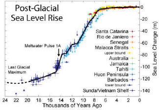
FIGURE 2.1 Changes in sea level since the last glacial period, showing a 130-m rise along with the relatively fast rates of rise beginning about 15,000 years ago.
SOURCE: Image created by Robert A. Rohde/ Global Warming Art. Based on data from Fleming, 2000; Fleming et al., 1998; and Milne et al., 2005.
(Ward, 2004). Starting from being nearly in balance during the early 1990s, Antarctica has been losing ice at an increasing rate and now contributes more than 0.5 mm to sea level rise each year (Rignot et al., 2011).
Antarctica’s accelerating ice loss is, at least in part, attributable to disintegration of floating ice shelves. Although the loss of floating ice shelves does not contribute to sea level rise directly, the ice shelves provide a back pressure against the flow of ice, essentially buttressing the interior ice locked up on land and preventing it from flowing quickly. Once ice shelves are lost, continental ice flows more rapidly into the sea. As predicted more than 30 years ago (Mercer, 1978), ice shelves along the Antarctic Peninsula of Antarctica have been the first to significantly deteriorate (Morris and Vaughan, 2003), owing to the overall warmer conditions in this region. This ice shelf loss has been followed by an acceleration of ice flow into the sea (Scambos et al., 2004), similar to events that have been observed in Greenland (Thomas, 2004). The Antarctic Peninsula does not contain much ice because it is located in warmer latitudes and is narrow, so the immediate consequences for sea level are not large. However, the question remains whether the loss of floating ice shelves and consequent acceleration of continental ice observed in the Antarctic Peninsula is a harbinger of what is to come in West Antarctica or other parts of East Antarctica.
On the continental interior, summer temperatures atop Antarctica’s ice shelves generally remain several degrees below freezing. A major question is whether future warming will lead to summer melting and jeopardize the stability of the ice shelves. Most
of the Antarctic continent has not warmed as much as the global average in recent decades, but paleoclimate records from the last interglacial period and climate model predictions for the end of this century indicate, respectively, that Antarctic temperatures have changed and will change more than the global average over longer timescales (Clark and Huybers, 2009). In addition to surface warming from the atmosphere, ocean warming may also lead to thinning and possible destabilization of ice shelves. Indeed, the grounding line of the Pine Island Glacier has been observed to be migrating inward toward the continent, apparently because of increased subsurface melting of that ice shelf caused by warming ocean water (Thomas et al., 2004).
The geometry of Antarctica’s ice also raises the concern that ice loss could substantially accelerate. Parts of the East Antarctic Ice Sheet and most of the West Antarctic Ice Sheet rest upon ground that is below sea level. The ice that extends above sea level literally weighs down upon the ice underneath, pressing it onto submerged ground. As the thickness of the ice sheet tapers toward its margins, it can lose contact with the ground to form floating ice shelves. In these regions, the ice sheet melts more rapidly because of the relatively warm ocean waters in which it bathes. When an ice sheet that is grounded below sea level loses ice, more of it will tend to float, which can lead to more rapid flow, more melting of ice, and even more rapid ice loss. Thus, loss of ice leads to more loss of ice, constituting a positive feedback that has the potential to accelerate sea level rise (Nicholls et al., 2007; Thomas and Bentley, 1978). For this reason, the West Antarctic Ice Sheet is sometimes referred to as the “weak underbelly” of Antarctica (Hughes, 1981).
Importance to the United States
The estimated range of sea level rise expected to occur by 2100 is 0.4 to 2 m (National Research Council, 2011e; Pfeffer et al., 2008), but these are back-of-the-envelope calculations based on extrapolations from current trends. Indeed, the 2007 Intergovernmental Panel on Climate Change (IPCC) report (IPCC, 2007) almost entirely neglected to account for changes in the rate at which Antarctic ice is discharged into the ocean on the basis that not enough is known about how to model these processes. Antarctic contributions to sea level are therefore largely considered “a known unknown,” wherein ignorance of likely outcomes hinders society’s ability to understand what will happen and what consequences might follow.
Globally, rising sea level is expected to threaten the homes and livelihoods of hundreds of millions of people by the second half of this century (see Box 2.2). In an assessment of exposure to coastal flooding by 2070, Miami and New York City ranked
BOX 2.2 THE RISKS OF SEA LEVEL RISE
High rates of economic and demographic growth during the past century have multiplied populations and the infrastructure placed along coastlines worldwide.This leads to not only local communities and commercial centers being placed at great risk from rising sea levels, but also to nations being faced with extremely high economic, societal, and security challenges. Examples of problems already being faced in the United States from rising seas include shoreline retreat along most U.S. exposed shores and intrusion of seawater into freshwater aquifers in coastal areas, which threatens freshwater supplies (National Research Council, 2010a). More than one-third of U.S. residents live near a coast, and more than $1 trillion is contributed annually to the nation’s economy from activities that occur on or along a coast (USGCRP, 2009). Future sea level rise poses risks to U.S. communities, coastlines, and infrastructure along much of the eastern and southern United States, the West Coast, and Alaska (see figure).
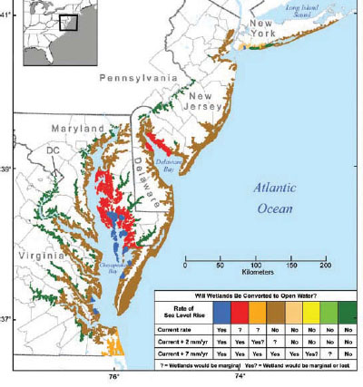
Potential mid-Atlantic wetland survival. Areas where wetlands would be marginal or lost under three sea level rise scenarios (in mm per year).
SOURCE: CCSP, 2009.
6th and 17th, respectively, in threatened impacts to the world’s major cities (Nicholls et al., 2007). In particular, rising sea level threatens to cause more frequent flooding by increasing the height of storm surges and the peak level of tidal cycles. Overtopping coastal levees on even a single occasion can have dire consequences, as evidenced by the results of Hurricane Katrina in New Orleans in 2005. Higher sea level also threatens wetland habitats, as the U.S. Climate Change Science Program reported (Titus and Anderson, 2009), namely that most of the mid-Atlantic coastal wetlands will be lost in the next century if local sea level rises by as much as 1 m. The U.S. Navy has taken steps to examine the potential impacts of climate change, including those from sea level rise, on future naval operations and capabilities (National Research Council, 2011e).
Global average sea level is, of course, less relevant than how much sea level will rise in specific locations—primarily where the sea meets where people live and work—and here lies a poignant wrinkle. Loss of ice weakens the local gravitational attraction that the ice sheet exerts on the ocean, leading to a reduction in sea level at the margin of the ice sheet. Further afield from where the ice loss occurs, sea level rises by more than its global average, with the specific locations of maximal rise depending upon the rotation of Earth and the geometry of the ocean basins. Local variations in sea level also depend upon changes in ocean circulation and storm activity. As it happens, loss of ice from West Antarctica would cause about a 15 percent greater sea level rise along the eastern and western United States than the global average, with the largest increase centered approximately at Washington, DC, highlighting how the United States is uniquely exposed to the fate of West Antarctica and the Antarctic ice sheet (Mitrovica et al., 2009) (Figure 2.2).
Questions for the Future
Two critical questions arise: How much will Antarctica contribute to a rising future sea level and how quickly? Antarctica’s ice sheets are strongly intercoupled with the fluid and solid portions of Earth, and developing an ability to predict their future behavior depends upon designing a comprehensive modeling and observing strategy. To give a sense of the system intercoupling, consider that determination of how much ice Antarctica has been losing in the past decade, based on satellite measurements of gravitational anomalies, requires knowledge of the rate at which the underlying bedrock is lifting. Determining bedrock uplift requires understanding the structural properties of the rock, as well as how much ice Antarctica has lost since the Last Glacial Maximum, some 20,000 years ago. As another example of linked system complexity, whether ice loss will accelerate depends, in part, upon the stability of the ice shelves
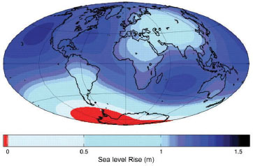
FIGURE 2.2 Sea level changes in response to a collapse of the West Antarctic Ice Sheet represented as an additional change relative to the global average of 5 m; this highlights the significant local deviations. Sea level rise is 15 percent higher than the global average along the U.S. coastline. Changes over land can be ignored.
SOURCE: Mitrovica et al., 2009, reprinted with permission from the American Association for the Advancement of Science.
bordering Antarctica, which in turn depends on their temperature, and therefore the circulation and temperature of the oceans and atmosphere.
Required Tools and Actions
The committee recommends five actions that are needed to advance prediction of Antarctica’s contribution to sea level in the future:
• Develop greater predictive capacity for the flow of ice into the ocean. Relative to the ocean and atmosphere, the dynamics of the cryosphere are poorly understood. This is partly because of difficulties inherent in observing and modeling ice flow: it is difficult to make physical measurements deep within and beneath ice sheets and ice shelves; many timescales of ice motion are longer than those afforded by instrumental records; and ice is a non-Newtonian fluid, whose motion depends sensitively upon its interactions with sediment or rock at its bed. As stated, the 2007 IPCC report neglected the possibility of change in the rate at which Antarctic ice is discharged into the ocean because not enough was known (IPCC, 2007), underscoring the need for further theoretical and observational work on ice sheets. Requisite work can be broken down ac-
cording to ice interactions with the ocean, atmosphere, and solid Earth and are described in separate bullets below. Improved theoretical understanding and technical capacity is also needed, as detailed next.
• Increase scientific and technical capacity to observe and model ice sheets. The cadre of theoreticians and those making observations related to the Antarctic ice sheet is small relative to the scope of the problem. Teams of collaborators would need to include glaciologists, geologists, oceanographers, atmospheric scientists, and so on, and expansion of existing efforts across federal agencies and academia. Those components of ice sheets that can change relatively rapidly, especially those associated with ice streams and ice shelves, require particular attention.
• Determine how the ocean transports heat to ice shelves and how this may change in the future. Antarctica loses the vast majority of its ice via interactions with the ocean. The amount of melting beneath ice shelves depends upon transport of heat by the oceans, which is driven by a complex mix of wind stress and changes in water density brought about by heating, cooling, and fluxes of salt- or freshwater. Recent modeling studies (Pollard and DeConto, 2009) highlight how an increase in ocean heat flux could lead to rapid inward migrations of ice shelf grounding lines and loss of ice volume. Developing instrumentation and an observational program with which to monitor the conditions beneath ice shelves is a high priority (see Appendix C for enabling technologies). In conjunction with increasing observations, improved models capable of accurately representing the transfer of heat from the ocean to the cryosphere need to be developed and tested (also see Section 2.2).
• Improve monitoring of surface temperature and ice accumulation. It is not entirely certain whether the temperature of Antarctica is or is not increasing. A general warming trend was reported for surface atmospheric temperatures, based on surface and satellite observation (Steig et al., 2009). But a recent report, using similar data but different statistical methods, found little evidence of warming (O’Donnell et al., 2011). At the heart of this discrepancy is the sparsity of the international Antarctic observational network, which places heavy demand on statistical methods for estimating temperature variations in regions where direct observations are not being made. Nonetheless, there are both model analyses and paleoclimate observations that strongly suggest that Antarctica will eventually warm significantly more than the lower latitudes (Clark and Huybers, 2009). A warming of several degrees Celsius could lead to significant summer melting atop the ice shelves and cause their disintegration, as recently observed for the Larsen ice shelf (see Figure 2.3) (MacAyeal et al., 2003; Mercer, 1978). Similar to the limited and widely scattered Antarctic
temperature observations (often obtained at international bases around the continent), there are large gaps in monitoring snow accumulation over Antarctica, as well as a significant partial evaporation of snowfall. Because satellite observations of ice temperature and snow accumulation are not sufficiently reliable, a comprehensive surface observing network is needed to define these basic surface conditions.
• Improve mapping of conditions and structures beneath the ice sheet and measuring uplift of underlying bedrock. Subglacial topography and the composition of the underlying rock are important determinants of glacial flow. Determining which regions are below sea level is important for evaluating instabilities in the ice. However, the subglacial topography and geology of Antarctica is less well known than the topography of Mars (Gwinner et al., 2010). Comprehensive radar mapping of Antarctica is required. Determining the rate of uplift of the bedrock beneath Antarctica, which is still adjusting to the unloading associated with the last major deglaciation (between 18,000 and 7,000 years ago), is also critical for monitoring and assessing the changes of the mass of the ice sheet. In particular, correct interpretation of gravitational anomalies monitored
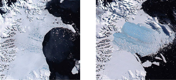
FIGURE 2.3 In 2002, the Larsen B ice shelf collapsed and delivered 3,250 km2 of ice into the ocean. These images are derived from satellite data from the MODIS (Moderate Resolution Imaging Spectroradiometer) instrument.
SOURCE: Cavalieri et al., 2008, National Snow and Ice Data Center, University of Colorado, Boulder.
from space requires measuring changes in the elevation of both the underlying bedrock and the overlying ice sheets. Bedrock uplift rates can be assessed both through Global Positioning System measurements as well as through models that incorporate the geologic history of changes in the size of Antarctic ice sheets. Lack of knowledge of the amount of bedrock uplift provides the largest source of uncertainty in determining the rate that Antarctica is losing its ice (Chen et al., 2009) (also see Section 2.4).
It is only through observations made in Antarctica that scientists were alerted to such phenomena as the ozone hole, rapid disintegration of the Larsen B ice shelf, acceleration of glaciers once the ice shelves were lost, and draining and filling of subglacial lakes. Given how limited direct observations of the Antarctic continent have been and how human actions are now prodding the climate system, many surprises seem possible in the future. In order to expect or learn from any surprises, there will need to be careful monitoring of Antarctica, including its ice, overlying atmosphere, and peripheral oceans. Observations made in Antarctica can be likened to an early warning network that, when adequately interpreted, analyzed, and placed into the context of a developed theoretical understanding, will alert society to acceleration of Antarctica’s ongoing contribution to changing sea level or, possibly, uncover new mechanisms by which Antarctica can change sea level.
2.2 WHAT IS THE ROLE OF ANTARCTICA AND THE SOUTHERN OCEAN IN THE GLOBAL CLIMATE SYSTEM?
Although Antarctica and the Southern Ocean are physically distant from the Northern Hemisphere, they are directly connected to the entire global climate system. Some of the connectivity with lower latitudes is rapid, through the atmosphere, with adjustments on short timescales of the order of days to months. Some of the processes are more remotely connected and have longer timescales; these include the Southern Ocean’s role in the global ocean overturning circulation and rate of carbon dioxide uptake. In stark contrast to the rapid warming of the Arctic, Antarctica and the Southern Ocean present a mixed picture of both climate change and climate variability.
Significant progress in understanding changes in the southern high-latitude coupled climate system over the next 20 years will require construction and operation of an observing system for the atmosphere, ocean, sea ice, and glacial ice. In parallel, successful predictive modeling will require greatly improved coupled modeling of all of the elements of the climate system and continuing improvement of the data-
assimilation models, similar to those used for weather prediction, ocean state estimates, and retrospective climate analysis.
Climate in all regions of the globe is affected by greenhouse gases and aerosols from human emissions. The Antarctic region is far from immune, given the amplified climatic response of the polar regions. Climate in the Antarctic region is also affected by ozone depletion in the stratosphere due to anthropogenic chemicals. International protocols have reduced the release of many ozone-depleting chemicals, resulting in stabilization of the ozone depletion (“hole”), but it will take several more decades until the ozone’s effects on climate will become insignificant (see Box 2.3).
The coupled climate system in the Antarctic region reaches from the stratosphere to the deep ocean and the continent, including the atmosphere, ocean, sea ice, and glacial ice. This section is organized by the various components of the climate system. Each subsection analyzes the global context, current knowledge, questions for the future, and required tools for that component.
BOX 2.3 THE OZONE HOLE AND GREENHOUSE GASES
The Antarctic ozone hole is generated by a blend of three factors operating in the stratosphere. First, chlorine gas mediates the destruction of ozone, and its 20th-century increase is due to the rise in atmospheric chlorofluorocarbon levels—long-lived chemicals produced by the chemical industry and used, for example, as coolants in refrigerators and air conditioners. This is why the ozone hole only began appearing around 1980; records prior to this period are quite limited. Second, cold temperatures are required to form stratospheric clouds from which the chlorine is released, which accounts for the occurrence of the ozone hole above frigid Antarctica. Third, sunlight is required to initiate chlorine formation and thus ozone destruction, which explains why the hole opens up in spring, as light returns to Antarctic latitudes. Ozone in the stratosphere absorbs ultraviolet radiation from the sun and heats up the stratosphere. Reduced ozone levels cause less absorption and therefore relative stratospheric cooling in the spring and summer above Antarctica, which also leads to cooler tropospheric temperatures (Solomon, 2004).
Greenhouse gases (for example, carbon dioxide and water vapor) absorb infrared radiation from the surface of Earth and trap the heat in the troposphere. If this absorption is very strong, the greenhouse gases retain most of the outgoing infrared radiation close to Earth’s surface. This means that only a small amount of this outgoing infrared radiation reaches the carbon dioxide in the upper troposphere and the lower stratosphere. On the other hand, carbon dioxide emits heat radiation, which is lost from the stratosphere into space. In the stratosphere, this emission of heat becomes larger than the energy received from below by absorption and, as a result, there is net energy loss from the stratosphere and resulting cooling. To summarize, elevated carbon dioxide levels can warm the surface and lower atmosphere, but cools the stratosphere (Uherek, 2006).
The Atmosphere
Global Context
The higher latitudes of the Southern Hemisphere, including the icy and mountainous continent of Antarctica and the surrounding sea ice zone, are among the coldest regions on Earth. Their perpetual ice and snow cover contributes to a large temperature contrast between the tropics and the South Pole, which in turn generates the strongest westerly winds on the planet. The Southern Ocean westerly winds buffer the Antarctic continent from the warmer, wetter, and dustier lower latitude atmosphere. These westerly winds drive the Antarctic Circumpolar Current in the ocean (see Box 2.4), force much of the global overturning circulation, and, along with the seasonal cycle of incoming solar radiation, influence the growth of sea ice. Even so, the climate of these high-latitude regions is modulated by a number of tropical effects, most notably the El Niño-Southern Oscillation.
The westerly winds have clear natural “modes” of seasonal to centennial variability. These modes also affect air and ocean temperature, sea ice, and ocean currents. Moreover, anthropogenic forcing (byproducts of mankind including greenhouse gases, aerosols, and ozone-depleting chemicals; see Box 2.3) affect the state of these naturally occurring modes, much as beating on a drum produces sounds that depend on the naturally resonant modes of the drumhead. The leading natural mode, the Southern Annular Mode, exerts its influence throughout the year and exhibits decadal to centennial variability. The Southern Annular Mode has a simple geographic pattern (Figure 2.4) and exists in two phases. The positive phase of the Southern Annular Mode corresponds to stronger westerlies and plays a role in Antarctic continental temperature trends, shifts of the Antarctic Circumpolar Current and deep-ocean warming, among other phenomena. Other natural modes, such as the Pacific Southern American pattern, often produce more complicated spatial structures. These have important consequences, including implications described later in this section (see Southern Ocean Sea Ice).
What Changes Are Occurring in the Antarctic Atmosphere?
Surface temperature trends vary by location over the Antarctic continent (O’Donnell et al., 2011; Steig et al., 2009):
• The Peninsula: Since the 1940s, the western side of the Antarctic Peninsula has become one of the most rapidly warming places on Earth, primarily during the
BOX 2.4 SOUTHERN OCEAN CIRCULATION AND GLOBAL OCEAN OVERTURN
The Southern Ocean circulation is central to the global overturning circulation, as it not only affects the Southern Hemisphere but also, for instance, exerts controls on the remote North Atlantic overturning, which impacts European and North American climate (see figure). Because both the North Atlantic and Antarctic branches of the global overturning circulation are important for long-term climate adjustment, their strength and forcings should be closely monitored. Locally, circulation and upwelling in the Southern Ocean affect its sea ice and ice shelves.
The Southern Ocean circulation is dominated by the eastward flow of the Antarctic Circumpolar Current, which encircles Antarctica, driven by westerly winds. To the south, between the Antarctic Circumpolar Current and the continent, lie the extensive clockwise gyres of the Weddell and Ross Seas, as well as the westward flow along most of the Antarctic continental margin. Large-scale upwelling occurs throughout the Antarctic Circumpolar Current system, because the direct effect of the westerlies is to push surface water northward (because of the Coriolis effect). Deep waters formed in all of the oceans are upwelled to the sea’s surface in the Antarctic Circumpolar Current system, different from all other upwelling systems that draw on waters only from the upper ocean.
The upwelled deep waters split and follow two very different paths, one through the upper ocean and one into the bottom and deep waters formed locally in the Antarctic (Figure 2.5). Along the upper ocean path, the upwelled water is warmed by the atmosphere and moves northward into the subtropical circulations in the Southern Hemisphere. It eventually finds its way to the far northern North Atlantic, where it sinks back to great depths as part of the North Atlantic branch of the global overturning circulation; these waters return to the Southern Ocean and are again upwelled. For the bottommost path, the upwelled water that is close to Antarctica is cooled to freezing, sinks to the bottom, and extends far into the Northern Hemisphere, moving slightly upward into the deep waters of each of the oceans and then returning back to the Southern Ocean. The key process that makes this water dense enough to sink to the bottom is the addition of salt rejected from the sea ice that is formed each winter. Sea ice production is largest in polynyas (pockets of exposed surface water, kept open by the winds) along the edges of the Antarctic continent and ice shelves. Very dense water is also created by brine rejection in the sub-ice cavity between the bottom of the ice shelves and the continental shelf, resulting in minimal air-sea gas exchange in these particular dense waters; ice melting in sub-ice cavities is an important process for ice shelf mass balance.
The upwelled deep waters are above the freezing point when they reach the upper ocean. Incursions of these relatively warmer waters beneath the sea ice and especially under the ice shelves are implicated in the changing melting rate of ice shelves (see Figure 2.6).
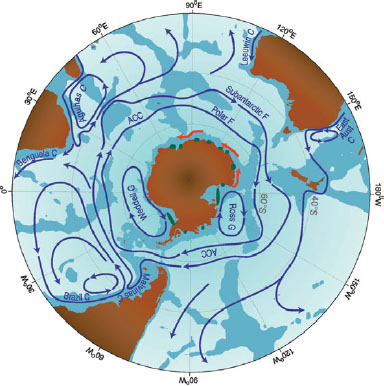
Schematic depiction of the major currents in the Southern Ocean south of 20°S. Southern Ocean circulation is very important to global overturning circulation. (ACC, Antarctic Circumpolar Current; F, Front; C, Current; G, Gyre). Green areas indicate principal polynyas where dense water is formed.
SOURCE: Adapted from Rintoul, 2011.
winter months. In contrast, the eastern side of the Peninsula is warming during summer because of strengthening of westerly winds that are primarily linked to stratospheric ozone depletion (Antarctic ozone hole) with a smaller contribution from increasing greenhouse gas concentrations.
• The Continent: The recent finding by Steig et al. suggests that all of West Antarctica is warming in winter and spring (1957-2006), while East Antarctica shows little change. Unfortunately, direct local temperature measurements are sparse over much of Antarctica, so these results remain controversial. Nevertheless, measurements obtained from the Siple Dome ice core in West Antarctica confirm that the climate there has warmed significantly since 1800 (SCAR, 2009).
Summer melting of the Antarctic ice sheet for 1979-2009 obtained from satellite observations appears strongly influenced by westerly wind variability associated with the Southern Annular Mode, as well as the El Niño-Southern Oscillation (Tedesco and Monaghan, 2009). Little overall trend is evident in the amount of ice sheet summer melting.
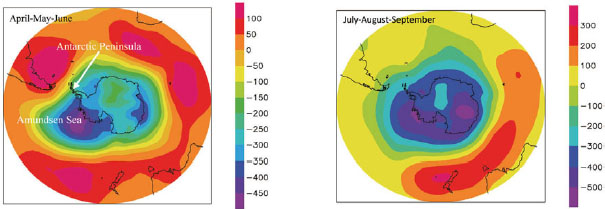
FIGURE 2.4 Spatial patterns of atmospheric surface pressure change associated with the Southern Annular Mode in Pascals for the average of (left) April, May, and June and (right) July, August, and September. The Southern Annular Mode describes variability of the surface atmospheric pressures or atmospheric flow that is not associated with the seasonal cycle. In the pressure field, the annular modes are characterized by north-south shifts in atmospheric mass between the polar regions and the middle latitudes; the figure shows the positive phase where pressures are lower over polar regions (cool colors) and higher in middle latitudes (warmer colors). In the wind field, the annular modes describe north-south vacillations in the extratropical zonal wind with centers of action located ~55-60°S and ~30-35°S latitude; the positive phase has stronger westerly winds along ~55-60°S latitude.
SOURCE: Goosse et al., 2011, data from NCEP-NCAR reanalyses (Kalnay et al., 1996).
Questions for the Future
Human-induced drivers of change, or human “forcings,” of the Antarctic atmosphere are mainly produced through stratospheric ozone depletion and greenhouse gas increases. These forcings may be contributing to the increasing Southern Annular Mode trend (strengthening westerlies) since the 1960s (Fogt et al., 2009) in the summer and fall. Greenhouse gas forcing cools the stratosphere even as it warms the surface. In opposite fashion, the forcing from ozone depletion causes the surface in East Antarctica to cool (see Box 2.3). The combination of these forcings cools the stratosphere, increases the equator-to-pole temperature gradient in the stratosphere, and hence strengthens the westerlies. Recent results have shown that ozone changes are the biggest contributor to the observed summertime intensification of the southern polar vortex during the second half of the 20th century, but that increases in greenhouse gases are also necessary to reproduce the observed trends (Arblaster and Meehl, 2006). At the surface of the ice, the effect of ozone forcing is presently comparable with the greenhouse gas forcing in Antarctica, so surface temperatures have not increased as much as they have in most regions of the planet. Because of treaty restrictions on chemical release, the ozone hole appears to have stabilized and is projected to recover over the next 50 years (Salby et al., 2011). As the cooling effect of the ozone hole disappears, the increased greenhouse gas forcing may quickly result in enhanced warming of the surface of East Antarctica while continuing to produce stratospheric cooling (Crow, 2011). This changing situation requires continuous monitoring.
The chemistry of the atmosphere at the continental ice surface sets the gases that are trapped in the ice, ultimately forming the record of the atmosphere that is included in ice cores (see Section 3.1). Antarctica is largely unexplored territory for atmospheric chemistry; what little has been done there in the way of observations has yielded surprises, including unexpected discovery of chemical radicals (Neff et al., 2008). Two field projects employing aircraft have extended observations to areas distant from the South Pole, but the data from these projects were insufficient to determine if the South Pole is representative of the entire continent (Eisele et al., 2008; Slusher et al., 2010). Overall, more observations are required to understand the chemistry of the atmosphere over Antarctica and will be necessary to more fully understand the connections of this region to global climate.
Existing observations of the winds, near-surface temperature, and snow accumulation in Antarctica are few and scattered about the continent in location and time because of the great difficulties of collecting such field data by humans. In many areas of Antarctica, observations are insufficient to describe either annual or seasonal variations. Other climatic elements such as surface pressure and cloud characteristics are even
more uncertain. With such limited observations, it is difficult to determine if there have been or will be climate changes in response to anthropogenic greenhouse gas (GHG) forcing. It is clear that prior meteorological data sets obtained on land and in the atmosphere, as well as analyses of the atmospheric state, which are based on intensive computer modeling at the national climate and weather prediction centers using these inadequate data sets, are insufficient to provide answers to the following basic questions:
• Is the Antarctic climate being adequately monitored as the ozone hole recovers?
• Is rapid climate change due to anthropogenic (GHG) forcing about to cause large changes in Antarctica?
• Would rapid climate change be detected with current capabilities if it were happening?
• How does the Antarctic ice sheet respond to rapid temperature changes? Would surface melting rapidly increase and accelerate ice flow into the ocean? Would increases in snow accumulation compensate for mass loss to the ocean?
Required Tools and Actions
To document what is happening, the two key variables to measure are near-surface air temperature and snow precipitation and accumulation. An observing network for both of these variables would benefit greatly if it were designed using computer simulations of the observing system, and if robust observing platforms were widely deployed and maintained. Strategic ice coring and borehole thermometry building upon the successful achievements of the International Trans-Antarctic Scientific Expedition project can form the basis for establishing the changes of these variables during past centuries. Vigorous research is needed into the best methods to interpolate continent-wide estimates from sparse scattered observations and to estimate the uncertainty. Data recorded by the observing network over long periods would produce benchmarks to test the performance of Earth system models. The paucity of direct stratospheric and tropospheric measurements from weather balloons can be partially remedied by incorporating new observing technologies and platforms, including satellite radiances, observations from constant-level balloons equipped with dropsondes (Rabier et al., 2010), self-sustaining blimps, and drones (see Appendix C).
A second goal is to develop greatly improved Earth system models. Major efforts are necessary to develop Earth system models that are optimized for understanding cli-
mate change in the Antarctic. In order to usefully project future changes, these models will need to skillfully simulate present and recent past climate conditions. At present, limited efforts are put into optimizing the atmospheric components of models, such as for the ubiquitous stable boundary layer over the continent that produces the katabatic winds that blow largely downslope and dominate the near-surface climate of Antarctica, the surrounding ocean, and the atmosphere above the continent. Antarctic cloud models and precipitation predictions are based on midlatitude experiences and do not consider the near-pristine conditions of the high southern latitudes or the major biological contributions to cloud condensation and ice nuclei. At present, most climate models have crude representations of the stratosphere and specify only the effects of stratospheric ozone depletion. Implementation of realistic stratospheric simulations along with understanding and incorporating ozone and greenhouse gas chemistry into climate models is needed to produce accurate simulations of the future behavior of the Southern Annular Mode, the leading mode of variability in the high-latitude southern atmosphere. All of these improvements will help improve the fidelity of models, which improves the accuracy of projected future changes from those models.
Ocean Circulation
Global Context
The energetic eastward flow of the Antarctic Circumpolar Current connects all ocean basins through the wide band of open ocean between Antarctica and the continents to the north. Extending from the ocean surface to the sea floor, the Antarctic Circumpolar Current separates subtropical and polar waters and their associated marine ecosystems (see Box 2.4). The Antarctic Circumpolar Current has strong, narrow fronts, across which temperature changes are great. With satellite observations, it has been discovered that strong fronts in sea surface temperature in currents like the Gulf Stream can affect the winds and storms above them (Chelton et al., 2004). Recent work in the Antarctic Circumpolar Current is showing that similar ocean-to-wind feedbacks might operate there. Nutrient-rich surface waters in the Antarctic Circumpolar Current sink to middepths north of its Subantarctic Front, providing the source for a large fraction of the global ocean’s primary productivity, and feeding the world’s great fishing grounds along its continental margins. Within and south of the Antarctic Circumpolar Current, seawater upwells from great depth, bringing nutrients and carbon and slightly higher temperatures to the sea surface. The polar circulation moves these waters southward and westward along the margins of Antarctica, where cooling and
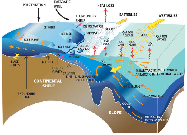
FIGURE 2.5 Cartoon of Southern Ocean circulation and glaciological processes occurring on the coast of Antarctica.
sea ice formation form the dense waters that contribute to filling the bottom layer of the world ocean (see Box 2.4 and Figure 2.5).
What Changes Are Occurring in the Southern Ocean?
Seawater at a depth of 700-900 m to the north of the Antarctic Circumpolar Current has been warming since the 1950s. Although some of the warming could be due to the warming atmosphere (Boning et al., 2008), the signal has been more closely linked to a southward shift in the current’s position associated with southward shifting of the westerly winds (Gille, 2002, 2008; Sokolov and Rintoul, 2009). While the westerly winds intensified over the same period, the strength of the Antarctic Circumpolar Current did not change (Boning et al., 2008).
• Bottom seawater, below 3,000 m depth, has warmed throughout the Southern Ocean, at a greater rate than bottom water in the basins lying to the north of this region, implying warming of Antarctic Bottom Water (Purkey and Johnson, 2010).
• Newly formed bottom water in the Ross Sea, which is one of the major producers of Antarctic Bottom Water, has freshened since the 1950s (Jacobs et al., 2002), and the trend has continued based on a major survey in early 2011. The principal cause is likely due to an increased amount of meltwater discharged into the sea beneath the ice shelves of West Antarctica; the decline in the mass of these ice shelves has been greater than anywhere else in Antarctica (Figure 2.6).
• The upwelled deep water comes close to the sea surface near the Antarctic continent; in the Ross Sea, this layer has warmed by about 0.2°C and has shoaled (become shallower) by about 50 m since the 1950s; both are significant causes of melting the Ross Sea ice shelves from below (Jacobs and Giulivi, 2010). These temperature and depth changes could be related to intensification of the westerly winds, which may have accelerated the clockwise seawater circulation in the Ross Sea. The shoaling of warming water could be a cause of the increased melting rate of West Antarctic ice shelves.
Questions for the Future
Climate change in response to greenhouse gas forcing in the Southern Ocean will come about as the ocean and cryosphere warm in direct response to warming of the near-surface atmosphere. Indirectly, as the winds respond to climate change, the Southern Ocean circulation and water properties will change. The interplay of consequences due to warming and freshening versus those due to intensified westerly winds could be complex and is not easy to project based on current understanding and modeling. Without a comprehensive observational system in place, and advanced modeling of the Southern Ocean’s circulation, sea ice, and ice shelves, it will not be possible to follow the near- and long-term responses to climate change.
There are several questions related to upwelling, stratification, and dense water production that will be important in the next 20 years:
• Will changes in the winds shift the location of the Antarctic Circumpolar Current, its fronts, and sea ice extent?
• Will changes in the westerly winds increase or relocate the upwelling of deep waters within the Southern Ocean?
• Will changes in upwelling of deep, warm waters and in ocean circulation south of the Antarctic Circumpolar Current increase melting of the (glacial) ice
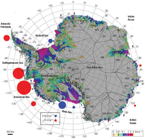
FIGURE 2.6 This image indicates the glacial surface velocities along the periphery of Antarctica and the mass loss (red circles) or gain (blue circles) of various Antarctic glaciers in gigatonnes per year. Data from satellite interferometric synthetic-aperture radar observations from 1992 to 2006 to estimate the total mass flux into the ocean, and mass fluxes from large drainage basin units with interior snow accumulation calculated from a regional atmospheric climate model for 1980 to 2004. The largest mass losses are from the glaciers from the West Antarctic Ice Sheet where it enters the Bellingshausen and Amundsen seas.
SOURCE: Reprinted by permission from Macmillan Publishers Ltd: Nature Geoscience (Rignot et al., 2008), © 2008.
shelves? If so, will the additional freshwater at the Southern Ocean’s sea surface, by increasing its stratification, reduce the effects of increased upwelling?
• Will formation of the bottom waters that fill the global ocean change (warming, freshening, weakening)?
There are also important questions related to connections of the Southern Ocean to the Northern Hemisphere:
• If the upper ocean waters that move northward out of the Southern Ocean are warmer and fresher, then will the stratification and upper ocean overturn in the midlatitude Southern Hemisphere increase?
• Will the North Atlantic’s deep overturning, far from the Southern Ocean, be affected by changes in Southern Ocean winds, overturning, and stratification?
Required Tools and Actions
The climate-interacting portions of the Southern Ocean’s circulation extend from the top to the bottom of the water column, and from the grounding lines of the ice shelves on the continental shelves for thousands of kilometers to the north, past the northernmost extent of sea ice to several hundred kilometers north of the Antarctic Circumpolar Current. Observations throughout this large area are particularly challenging because of stormy conditions with extremely large wave heights, seasonal sea ice cover, the long polar night, and the extraordinary challenge of observing within sub-ice cavities deep beneath the floating portion of ice shelves. Key parameters to measure throughout the water column are horizontal velocity, temperature, salinity, and oxygen. Biological productivity and carbon uptake also need to be studied (see next section), with measurements of nutrients and two or more of the carbon system parameters (pH, alkalinity, partial pressure of CO2 (PCO2), and dissolved inorganic carbon). Ocean modeling that assimilates data (with frequent reanalyses) and predictive ocean modeling are also essential.
The air-sea momentum (wind forcing), heat, and freshwater fluxes that govern the dynamics of the Southern Ocean occur in a very complex environment that includes a 1,500-km extension of the sea ice edge northward in winter and the retreat of sea ice back to the continent each summer (around much of Antarctica). Fluxes through the pack ice are difficult to quantify, providing one of the major challenges to be met by any successful future observational campaign over the next several decades. The largest heat losses from the ocean occur within regions less than 100 km from the Antarctic coast and ice shelf margins. Observations of air-sea fluxes of heat, freshwater, and CO2 present major instrumental challenges (Bourassa et al., In press). Enormous
improvements in measurements of present day air-sea flux components would be essential; these are now provided only by estimates from atmospheric reanalyses that are based on satellite observations and exceptionally sparse local observations (e.g., National Centers for Environmental Prediction, European Centre for Medium-Range Weather Forecasts).
A comprehensive proposal for an international Southern Ocean Observing System (SOOS) has been published (Rintoul et al., 2011). This planned system would become a part of the Global Ocean Observing System,3 which is organized under the Intergovernmental Oceanographic Commission of the United Nations Educational, Scientific and Cultural Organization. SOOS will be comprised of a large suite of observational instruments to analyze the water column, including profiling floats, moored time series stations, routine gliders, and miniaturized sensors for biology and biogeochemistry, with a broad additional range of satellite and in situ instrumentation. If implemented, SOOS would make a significant contribution to answering many of the important questions above.
Southern Ocean Carbon Uptake and Ocean Acidification
Global Context
The Southern Ocean is an extremely important region of the globe for air-sea exchange of carbon dioxide (CO2), second only to the northern North Atlantic (see Figure 2.7). The Southern Ocean hosts a large and diverse ecosystem, from the microorganisms in the seawater to the largest marine mammals. Rising temperatures due to higher levels of greenhouse gases will affect many aspects of the Southern Ocean and Antarctica’s climate. As CO2 levels rise in Earth’s atmosphere, there will be (1) changes in CO2 exchange with the sea which will alter atmospheric CO2 levels, and (2) effects from increased dissolved CO2 to increase ocean acidity that reduce the availability of calcium carbonate for shell and bone formation in many marine organisms.
On balance, the whole of the Southern Ocean is a net sink for excess anthropogenic atmospheric CO2, but there are large, counterbalancing elements, and the relative importance of these elements can shift. The balance is currently dominated by CO2 uptake in the deep mixed layers just north of the Antarctic Circumpolar Current. However, CO2 release occurs both within and south of that current, where deep waters upwell to the sea surface. These deep waters come from the Atlantic, Indian, and
________________
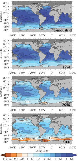
FIGURE 2.7 The effects of ocean acidification at the sea surface are illustrated with maps of the surface water aragonite saturation state showing where calcium-carbonate-based structures (like shells) would be dissolved: values <1 are undersaturation of seawater with respect to aragonite, indicating that there would be dissolution. These maps highlight the sensitivity of the Southern Ocean under greenhouse gas forcing scenarios. Maps for “pre-industrial” (1765) and 1994 are based on observations and extrapolation from observations; maps for 2050 and 2100 are the average of 13 ocean general circulation models under an IPCC “business-as-usual” scenario (Orr et al., 2005).
SOURCE: Fabry et al., 2008, by permission of Oxford University Press.
Pacific oceans; because they have been far below the sea surface for up to hundreds of years, they have accumulated excess carbon. The westerly winds are expected to increase in strength in response to increased greenhouse gases (see earlier section, The Atmosphere), which will both increase the deep water upwelling rate (and carbon release) and possibly also enhance deep mixed-layer formation (carbon uptake). Increasing seawater temperatures will also lower carbon dioxide solubility in seawater and change the overall chemical equilibrium in seawater.
What Changes Are Occurring in the Southern Ocean?
Ocean acidification is the “other CO2 problem” (Doney et al., 2009; National Research Council, 2010d) (see Box 2.5). The lowering of pH is a response of the carbonate buffer system in seawater to anthropogenic CO2 uptake into the ocean. The problem is greatest in cold polar waters because the low temperature increases CO2 solubility and decreases the saturation level; the result is that the polar oceans could experience decreases in carbonate saturation to harmful levels by midcentury. Much of the anthropogenic CO2 that has been absorbed by the ocean is in the North Atlantic, but the Southern Ocean north of the polar front zone also shows a large CO2 increase over the past decade. The mean Southern Ocean surface pH has already declined measurably (by 0.1 unit) (National Research Council, 2011b).
The principal concern of acidification is not the direct effect of reducing pH but the associated decrease in carbonate saturation, which makes it more difficult for marine organisms to build and maintain their calcium carbonate shells and other body parts. Some direct effects of acidification on calcification and growth of particular organisms such as coccolithophorids, crustaceans, and corals are beginning to be described, but higher-level effects on ecosystems are very poorly understood. For example, how will Antarctic food chains change if organisms such as krill and pteropods (small winged mollusks) are vulnerable to acidification? The implications for predators consuming krill, such as seabirds, seals, and whales, are unclear, as are the impacts on fish and fisheries.
Acidification will interact with other processes of change, such as ocean warming, in complex and hard-to-predict ways. For example, recent warming of deep waters along the Antarctic Peninsula appears to allow the invasion of predatory crabs. Crab physiology is sensitive to cold temperatures, so they have been absent from Antarctic seas since the Eocene, approximately 56 to 34 million years ago, and benthic mollusks have not experienced recent evolutionary contact with shell-crushing predators. The shells of these calcified organisms may be weakened by future acidification, rendering them
BOX 2.5 OCEAN ACIDIFICATION MECHANISMS
As the concentration of carbon dioxide (CO2) increases in the atmosphere, more CO2 dissolves in the world’s oceans. The solution of more CO2 in the ocean leads to the formation of more carbonic acid (H2CO3) and more hydrogen ions (H+). Acidity is defined by the concentration of hydrogen ions, so, as CO2 increases, the oceans become more acidic.
Calcium carbonate (CaCO3), composing the shells of many organisms, is often thought of as insoluble “chalk” with two crystalline forms, calcite and aragonite. CaCO3 is, however, in equilibrium with calcium (Ca2+), carbonate (CO32–), and hydrogen ions in the surrounding ocean. Increases in hydrogen ion concentrations result in a depletion of carbonate (CO32–), causing desaturation of the ocean levels of calcium carbonate and subsequently the dissolution of calcite or aragonite in the skeletons of marine organisms (see figure). In addition because freshwater is 10 times more acidic (pH 7) than normal ocean water (pH 8), significant input of freshwater (from melting ice) will also reduce carbonate levels and cause dissolution of the calcium carbonate skeletons of ocean organisms. This is why calcium carbonate saturation levels depend on ocean salinity. There is also a depth or pressure dependence of carbonate levels.
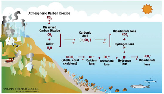
Cartoon depicting chemical mechanisms involved in ocean acidification.
SOURCE: National Research Council, 2010d.a
_____________________________
even more vulnerable to invading predatory crab populations in Antarctica (Thatje et al., 2005). There is also additional concern that altered pH will cause physiological challenges that induce a metabolic cost to organisms, thereby changing the performance of even noncalcifying organisms.
Questions for the Future
A major question is how the rate of CO2 uptake, and the resulting acidification of the Southern Ocean, will change as the overall climate system changes (warming, wind stress, position of frontal systems in the Antarctic Circumpolar Current, rates of ocean upwelling). The upwelled deep waters of the Southern Ocean carry excess CO2 as compared to surface water, which means they are slightly more acidic and will impede future CO2 uptake from the atmosphere. Warming will increase the flow of freshwater from melting glaciers into the sea. This freshwater input has less capacity to absorb excess CO2 from the atmosphere and is thus more prone to acidification. The question then is, Will there be increased ocean acidification associated with increased glacial melt? A major question in global change biology is whether organisms will have the genetic ability to adapt or the physiological plasticity to remain in place and tolerate these new conditions. There is also the impact on biogeographic range that might be an issue for polar organisms, that is, where to migrate to find colder temperatures.
Another major concern is the proposed global-scale sequestration of liquefied CO2 within the deep ocean (National Research Council, 2011b) as a means to partially mitigate the buildup of anthropogenic CO2 in the atmosphere. CO2 capture and direct injection into the deep sea bypasses the surface layer and avoids many of the expected consequences of acidification. However, the effects of enriched CO2 levels on deep sea food webs are unknown, as is the ultimate stability and fate of deep sequestered CO2.
Required Tools and Actions
Over the next 20 years, the committee anticipates the deployment of a comprehensive observation system to monitor the changing state of the Southern Ocean carbon system, including pH sensing packages to follow acidification at the scale of individual organisms. Accompanying the new data streams from the observational infrastructure would be new information management capabilities, new models, and sophisticated physiological studies to understand the responses of biota to chemical and physical changes in the ocean environment.
Intensive study of the components of the Southern Ocean carbon system will require sustained, year-round observations from moorings, floats, gliders, and autonomous underwater vehicles (see Appendix C) that can sample under sea ice as well as in open water. These observations will need to include chemical (e.g., pH, alkalinity, dissolved inorganic CO2, PCO2) and biological measurements, as well as physical measurements (velocity, temperature, salinity). Some of these measurements will require novel and robust sensors. The response of the carbon system to changes in the strength of westerly winds, increasing temperature, and freshwater influx needs to be documented as the climate changes. Targeted experiments for key polar species should document their response to calcium carbonate undersaturation associated with ocean acidification. Changes in interactions between species, food webs, and ecosystems need to be documented. Climate change will bring changes in seasonal sea-ice cover, warming, and southward expansion of the range of lower-latitude species, which should be documented. The SOOS implementation plan (Rintoul et al., 2011) presents a detailed proposal for observing the chemical, biological, and physical components of these interacting systems.
Southern Ocean Sea Ice
Global Context
Sea ice covers most of the Southern Ocean in winter and extends as far north as 55°S in places, almost 1500 km from the continent of Antarctica. In summer the ice melts almost all the way back to the continental and ice shelf margins, cycling between coverage of 15-16 million km2 in winter to 2 million km2 in summer (NSIDC, 2010) (Figure 2.8).
Southern Ocean sea ice is a critically important agent in the Antarctic and global climate system. Sea ice anomalies (deviations from the average amount of sea ice) can persist for several months and have the potential to strongly affect the variability of both the atmospheric and oceanic circulation. Sea ice reflects a large percentage of incident solar radiation, which changes the rate of solar heating of the ocean and atmosphere. Locally, sea ice controls the rate of heat exchange between the ocean and atmosphere. Globally, it helps to maintain the equator-pole temperature gradient, thereby exerting control over global atmospheric and hence oceanic circulation. Sea ice influences the Southern Ocean circulation by reducing sea surface temperatures, redirecting surface currents, and creating dense waters when salt is rejected as the ice forms. Sea ice affects the underlying marine ecosystems. Sea ice also greatly complicates the deployment of sensors and instruments for continuous observations within
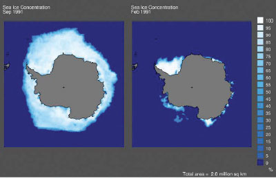
FIGURE 2.8 Sea ice coverage cycles between winter and summer. Winter (September, left) and summer (February, right) sea ice cover in 1991.
SOURCE: National Snow and Ice Data Center, University of Colorado, Boulder.
the water column and measurements of air-sea fluxes, as well as measurements of surface conditions from satellites.
What Changes Are Occurring to Antarctic Sea Ice?
In the Arctic, the decrease of sea ice cover for at least the past 30 years is attributed to global warming. In contrast, there has been a very small increase in Antarctic sea winter ice cover over the same 30 years (Figure 2.9). Unlike the Arctic, where the reduction in sea ice extent has been spatially coherent, in Antarctica sea ice trends have a strong regional variability. While sea ice extent has decreased markedly in the Bellingshausen/Amundsen and western Weddell seas, it has increased in the Ross Sea. These opposing regional trends, arguably as large as the Arctic sea ice trends, have resulted in a positive trend of about 1 percent per decade (Cavalieri and Parkinson, 2008).
In the long term, with continuing anthropogenic release of greenhouse gases, the atmosphere will continue to warm and winter Antarctic sea ice extent is expected to be much reduced (in summer it retreats to the continental edge around much of the continent as part of the normal annual cycle), as projected for the next century by IPCC models. This simulated decrease is likely to accelerate as the surface cooling associated with ozone forcing declines. The volume of winter sea ice that is formed is
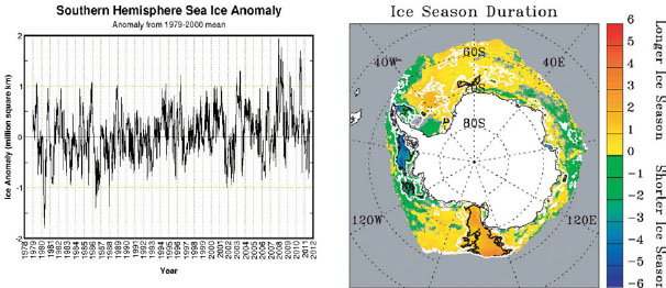
FIGURE 2.9 Unlike in the Arctic, sea ice trends in Antarctica have strong regional variability and winter sea ice cover has slightly increased over the past 30 years: (top) Antarctic sea ice cover anomalies (difference from the 1979-2000 mean) and (bottom) trend in ice season duration (days/year) for 1979-2004. SOURCES: (top) Cryosphere Today, University of Illinois at Urbana-Champaign, (bottom) Stammerjohn et al., 2008, Copyright 2008 American Geophysical Union, reproduced by permission of American Geophysical Union.
also expected to shrink, leading to thinning of the ice, in the same way as observed in the Arctic. Sea ice loss is expected at all longitudes and especially in the West Antarctic vicinity. Such reduction in the seasonal cycle of sea ice concentration and volume would lead to a reduction of brine rejection at the margins of Antarctica. This will influence the future formation of Antarctic Bottom Water (Sen Gupta et al., 2009) and could thereby weaken the strength of the deepest cell of the global overturning circulation (see Figure 2.10).
Questions for the Future
Much of what is known about Antarctic sea ice surface area and thickness, variability, and change is limited to what satellites have observed since the satellite observation record began in 1979. Some of this information is supported by very sparse direct surface observations. One recent project, Sea Ice Mass Balance in the Antarctic, uses a variety of remote sensing measurements including altimetry data and passive and active radar to create a baseline data set for future observations. Using this baseline, scientists can more accurately monitor changes in the sea ice balance. The data can be used in model validation and in validation of the satellite observations and can
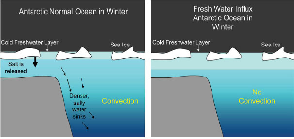
FIGURE 2.10 Schematic depiction of the potential disruption of normal ocean convection by an influx of meltwater that dilutes the Antarctic surface water leading to loss of convection. This could have implications for global overturning circulation.
SOURCE: T. Budinger.
facilitate better future predictions of sea ice cover. This can potentially help scientists understand why current climate models predict a decline in Antarctic sea ice over the 20th century while observations show a small increase.
Overall, the explanations of the satellite-observed spatial variation have primarily relied on those offered by atmospheric circulation mechanisms, rather than by complete explanations that include the entire climate system. Although much has been learned, large knowledge gaps remain, in particular the following:
• Atmospheric circulation mechanisms explain only a portion of sea ice trends; what accounts for the remainder?
• The ocean certainly plays a role in sea ice variability, but to what extent?
• What are all of the potential feedback mechanisms between the loss of Antarctic sea ice and the global climate?
• As they become more sophisticated, can climate models faithfully reproduce sea ice variability and extent in their simulations?
• Given that sea ice is a critical component of the global climate system, research in the Antarctic region should include efforts to understand these gaps in the observations and understanding.
Required Tools and Actions
Answers to the foregoing questions require better understanding of the sea ice–climate system interaction, especially the factors controlling sea ice formation, transport, and decay. Achieving realistic sea ice projections hinges on simultaneous (or concurrent) improvement in sea ice observations and climate models, in particular the sea ice component of models. Improving the sea ice component models will require two types of observations: process-scale observations to develop, refine, and constrain the model parameterizations, and large-scale observations to validate the large-scale simulated patterns. To facilitate this, sustained small-scale (i.e., surface) observations of sea ice cover (i.e., concentration), thickness, and extent are needed, as well as simultaneous observations of the oceanic and atmospheric variables that contribute to the presence of sea ice. These include ocean-ice-atmosphere heat flux as well as observations within the water column. At the large scale, data sets with good spatial and temporal coverage of mean sea ice thickness would reduce current model errors in sea ice concentration and extent. If this information were available, along with continued satellite coverage of ice concentration and extent, it should immediately improve simulations. Therefore, to reduce the uncertainties, a combined program of sustained observation of sea ice parameters and advanced climate model development, with sea ice information fed into the climate models, is needed.
Within the next 20 years the committee believes that a better understanding of the sea ice–climate system interaction, especially the factors controlling sea ice formation and decay, is possible. From this improved understanding the goal of simulating realistic projections of past, current, and future Antarctic sea ice conditions is realizable.
The Southern Ocean’s Interaction with Glacial Ice
Global Context
The edges of the continental ice sheet extend into the ocean in massive ice shelves that cover about half of the circumference of Antarctica (Figure 2.6). They typically extend about 100 km offshore of their grounding line. The ice shelves in the semienclosed Weddell Sea (Filchner and Ronne ice shelves), Ross Sea (Ross Ice Shelf), and Prydz Bay (Amery Ice Shelf) are even more extensive. The ice shelves are typically 200-700 m thick. Climate change has already led to warming of the global atmosphere that, in turn, has caused melting in and near the Antarctic Peninsula. Massive breakups of ice shelves observed during the past several decades along the Antarctic Peninsula have triggered faster loss of ice from the land-fast glaciers behind them (Scambos et
al., 2004). The impact of increased glacial ice loss on sea level rise was discussed previously (Section 2.1).
A crucial component of the climate system in the Antarctic region is interaction of the ocean with glacial ice. Beneath the ice shelves there is interaction between the ice, seawater, and glacial meltwater that drains out from under the continental glaciers (Figure 2.5). The seawater that flows through the sub-ice cavities under the ice shelves is cooled to freezing and becomes part of the very dense bottom waters forming around the continental edge. The plumes of this ice shelf water typically contain up to a few per mil of pure glacial meltwater that freshens the salty shelf waters or is incorporated into the plumes of newly formed Antarctic Bottom Water. The addition of this glacial freshwater can influence Antarctic Bottom Water formation (see earlier section, Ocean Circulation) and enhance Southern Ocean acidification (see earlier section, Southern Ocean Carbon Uptake and Ocean Acidification). Understanding the rate of change of glacial ice melting due to the influence of the ocean is critical to understanding the climate system in Antarctica and the Southern Ocean.
What Changes Are Occurring to Antarctic Glacial Ice?
The seawater in sub-ice cavities melts the ice shelves from below, a primary factor in the mass balance of the shelves. The rate of melting depends on initial seawater temperature, temperature of the glacial ice, and the pathways of shelf waters flowing underneath the floating ice shelves. A few estimates of glacial ice melt rates underneath floating ice shelves have been obtained by measuring the chemistry and temperature of waters flowing into and out of the sub-ice cavities (Loose et al., 2009; Schlosser et al., 1990). Such estimates have large uncertainties.
Upwelled deep waters, which are well above freezing, can reach the Antarctic shelves, enter the shelf water region, and enhance the melting of glacial ice from below. Recent observations suggest enhanced interaction between the upwelled deep waters and the ice shelves and sea ice (Jacobs et al., 2002). Increasing winds are projected to increase upwelling rates, which would enhance subglacial melting. Waters in front of West Antarctica’s Pine Island glacier have shown enhanced meltwater fractions (Figure 2.6) and a loss of mass detected by satellite observations. According to satellite observations, several other ice shelves are losing mass. It is believed that a good fraction of this mass loss is due to melting from below (Rignot and Jacobs, 2002). Major questions arising from these observations include the nature of the processes by which ocean-glacial ice interactions contribute to the thinning of floating ice sheets and how this contribution might change in the future.
Questions for the Future
There is an urgent need to better understand the dynamics of the ocean-glacial ice interaction beneath floating ice shelves, to improve the estimates of their melting rates, to establish the rate at which the ocean-glacial ice interaction adds freshwater to the global ocean, and to determine changes in the preconditioning of the shelf waters that flow underneath the ice shelves. This improved understanding will contribute to better projections of future sea level rise caused by melting of glacial ice in Antarctica. Over the coming decades, scientists should acquire both the data and modeling capacity to be able to quantify the amount of freshwater released from melting glacial ice into the ocean, as well as produce better projections of future melting rates.
Required Tools and Actions
There are several methods that will need to be applied in combination to answer the questions posed above. They include the following:
• Long-term measurements of the properties and circulation patterns of the continental shelf waters adjacent to floating ice shelves, including their variability and change (hydrographic sections, moorings).
• Observations of the seawater and the glacial outflows beneath floating ice shelves and their variability and change (autonomous underwater vehicles [AUVs], under-ice drifters, and instruments deployed via holes drilled through the ice shelves), including advanced technologies for launching and recovering autonomous vehicles that can provide continuous monitoring of salinity and temperature profiles in the cavities under ice shelves and under sea ice during the Austral winter.
• Studies of the connectivity between shelf waters and the Antarctic Circumpolar Current with its “relatively warm” Circumpolar Deep Water to estimate the heat flux onto the ice shelves and the transport of ice shelf water off the shelves (hydrographic sections, AUVs, drifters or gliders, and moorings).
• Satellite measurements of the elevation changes of Antarctic floating ice shelves.
• Improved modeling of the ocean-glacial ice interaction at the front of the ice sheet and beneath floating ice shelves.
The Climate System
Overall, a systems approach to the future of climate–glacial ice–sea ice–ocean science in Antarctica is needed. Perhaps even more intimately than in the Arctic, these systems are inextricably linked in Antarctica. Comprehensive understanding of the global system requires understanding of the Antarctic and Southern Ocean region. Earth system modeling facilitates this approach and will allow scientists to understand past and current events as well as predict the future.
To apply an efficient systems approach in Antarctic studies scientists have to continue to improve the understanding of subsystems that frequently suffer from poor observational records, especially concerning seasonal cycles, and poor characterization of their dynamic features. Simultaneous efforts to increase the density and scope of observations and quantitative description of the subsystems using conceptual, analytical, and numerical models should provide researchers with the information needed to design observing systems and models that can capture the main features and resonance points of Antarctic and the Southern Ocean as a whole. In a final step, such Antarctic and Southern Ocean observing systems and models have to be integrated into comprehensive Earth system models. These activities are not seen as occurring sequentially, but rather they should take place simultaneously to take advantage of synergies that can be gained by exchange between the communities working primarily on regional and global scales, respectively.
Ultimately, models require observations to improve process understanding and to validate predictions. The foremost need to improve the understanding of the role of Antarctica and the Southern Ocean in the global climate system is significantly increased observational capacity in Antarctica and the Southern Ocean.
2.3 WHAT IS THE RESPONSE OF ANTARCTIC BIOTA AND ECOSYSTEMS TO CHANGE?
Global Context
Although Antarctica is well known for its penguins, seals, and whales, recent research has revealed an abundance of other life forms, including active food webs in freshwater lakes and soils that extend beyond 80°S. The previous concept of terrestrial, freshwater, ice, and marine systems in Antarctica having only short food chains of low diversity has evolved as more species are discovered and a greater diversity is recorded in habitats once considered lifeless. Nevertheless, the magnitude of the impacts of global
change on the structure and functioning of terrestrial and freshwater systems are readily detectable compared to nonpolar systems containing many more species.
The Southern Ocean is characterized by extreme gradients in biological productivity. The deep waters are rich in nutrients that have accumulated from the continuous rain of organic debris from the sunlit euphotic zone in the surface layer throughout the world ocean. These nutrient-rich waters upwell and effectively fertilize the surface layer (Figure 2.11). In much of the Southern Ocean, plant production is limited by the availability of iron. The most productive regions are the continental shelves and other regions, where the strong currents of the Antarctic Circumpolar Current scour the continental shelves, harvesting iron from the sediments, resulting in much higher produc-
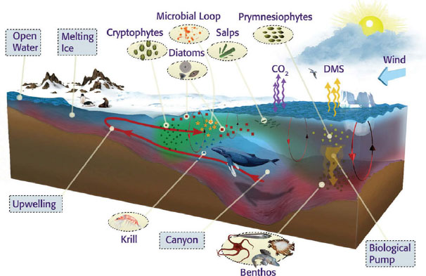
FIGURE 2.11 Cartoon view of the marine ecosystem of the west Antarctic Peninsula. The system is currently characterized by large predators such as penguins, seals, and whales, sustained by upwelling that supports high productivity and large krill populations. But these typical Antarctic food chains might be in a process of transformation into a new system dominated by gelatinous salps and microbes—dead ends in the food chain.
SOURCE: Coastal Ocean Observation Lab, Rutgers University.
tivity downstream. Further offshore, where the availability of iron is limited, the open Southern Ocean is a marine desert of low productivity (Moore et al., 2001).
Similar gradients exist on land as well. The Antarctic Peninsula is becoming slightly greener as temperatures warm and glaciers recede. Other Antarctic terrestrial ecosystems are among the simplest and most oligotrophic on the planet, nurtured as much by stores of “legacy” nutrients and organic matter accumulated over millennia as by contemporary production.
These variations make Antarctica and the Southern Ocean a unique, living laboratory for the study of ecosystem change. Ecosystems in Antarctica are simple enough that they can be studied for rules on how they respond to change, yet they are sufficiently complex that they are analogous to ecosystems in the rest of the globe.
What Environmental Changes Are Occurring?
The Antarctic region, once considered pristine, is no longer as isolated from or immune to changes that are occurring globally. The marine and terrestrial ecosystems of Antarctica have evolved largely in isolation from the rest of the planet since the opening of the Drake Passage approximately 30-40 million years ago and the establishment of the Antarctic Circumpolar Current, but remote forcings such as climate change, global transport of pollutants, invasive species, and increased ultraviolet radiation are altering biotic communities across the Antarctic continent. Other environmental changes include the local effects of increasing human presence due to tourism and scientific research, where visits to the continent from both activities have grown dramatically since the 1950s (National Research Council, 1993). The ecological system may still be recovering from the harvesting of whales, seals, and penguins that was prevalent in the first part of the 20th century. With increasing human presence come accompanying concerns about habitat destruction, overfishing, pollution, and other toxic effects on the environment. Contamination from oil spills and the disposal of waste remains a serious concern. In addition, the introduction of alien species and diseases into these areas can be harmful to indigenous wildlife populations and ecosystems (Frenot et al., 2005). The effects from the combination of these factors on Antarctic ecosystems are generally not known.
Of the various human influences, the impacts from human-induced climate change may prove to be the largest. Climate variability and change alter temperature and precipitation; some regions experience long-term increases, and some have decade-scale periods of cooling interrupted by brief warming events (see Box 2.6). Less than 0.5 percent of the continental land surface is exposed, including nunataks, cliffs, and seasonal
BOX 2.6 ANTARCTIC ECOSYSTEM RESPONSES TO CLIMATE VARIABILITY REVEALED BY
The Palmer and McMurdo Dry Valleys Long Term Ecological Research (LTER) projects have maintained observations of environmental variability and ecosystem responses since the early 1990s. Today research findings from these projects are among the best examples documenting the responses of marine and terrestrial ecosystems to climate forcing. Comparison of the responses of these diverse ecosystems is helping scientists to construct a general theory of ecosystem response to climate change and devise better models to predict how Earth’s ecosystems will change in the future under specific climate change scenarios (National Research Council, 2011d).
The climates of the western Antarctic Peninsula marine ecosystem studied by Palmer LTER and the polar desert of the Dry Valleys studied by the McMurdo LTER are both poised near the freezing point and are thus potentially vulnerable to large alterations in ecosystem behavior as temperatures warm or cool, and change the balance between freezing and melting of ice. Polar marine ecosystems are very strongly influenced by the dates of advance and retreat of sea ice as well as the annual duration of sea ice cover and its areal extent. Organisms from the base to the top of marine food chains have life cycles adapted to the annual rhythm of sea ice advance and retreat. Similarly, the organisms in Dry Valley soils depend on the flow of liquid water from melting glaciers and permafrost in summer. Coordinated meteorological and ecological observations show the common denominators of how populations of organisms have responded to environmental variability in these two contrasting ecosystems.
In the Palmer Station region of the Antarctic Peninsula, the mean winter (June-July-August) air temperature has risen by 6°C since 1950, and, in consequence, the duration of sea ice cover has declined by more than 80 days since 1978 (Figure 1) (Stammerjohn et al., 2008). The Dry Valleys have experienced a period of cooling since at least 1986, with attendant changes in lake levels (Figure 2) (Doran et al., 2002). Both systems experienced bottom-up changes at the base of their food webs and also top-down effects on apex predator populations. In the marine ecosystem, phytoplankton stocks declined in the north and increased in the south in response to changes in sea ice, winds, and ocean mixing (Montes-Hugo et al., 2009). At the same time, the Adélie penguin population declined by 80 percent in response to both direct warming effects and food reduction moving up from the base of the food web (Figure 1) (Schofield et al., 2010). In the Dry Valley lakes, the rate of photosynthesis (primary production) declined as ice thickened, reducing light penetration into the water. The nematode top predators in the soil declined by 50 percent as soils dried in response to colder temperatures (Figure 2).
In addition to nonlinear, and possibly long-lasting, changes due to steady climate forcings, ecosystems can also experience long-lasting effects due to sudden pulses or events such as unusual weather over the course of a single season. A hemisphere-wide atmospheric circulation anomaly in spring-summer 2001-2002 caused unusually warm temperatures across the continent (Massom et al., 2006). On the Peninsula, catastrophic late-season snowfalls and later flooding caused the largest single-season decline in Adélie penguin breeding success in 30 years (Figure 1). The effects of this loss of an entire breeding cohort are still evident 10 years later. In the
Dry Valleys, record high temperatures and glacier runoff returned lake levels to pre-1986 highs, erasing the effects of 15 years of cooling in just a few weeks (Doran et al., 2008). The extreme increase in soil moisture levels caused a reorganization in soil nematode species composition that was still evident in 2008 (Barrett et al., 2008).
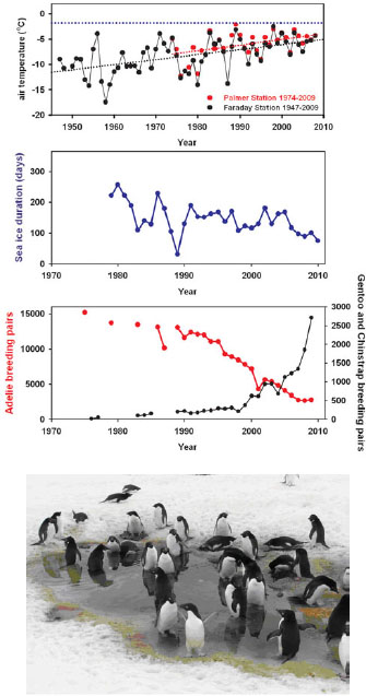
FIGURE 1 Climate variability and ecosystem response on the western Antarctic Peninsula; as temperatures have warmed and sea ice duration has decreased, Adélie breeding pairs have decreased while those for Gentoo and Chinstrap penguins near Palms have increased. Top: surface air temperature at Faraday Station (now Vernadsky Station), 1947-2009 (black) and Palmer Station, 1974-2009 (red). The blue dotted line is the freezing point of seawater (−1.8°C). Middle: duration of sea ice cover at Palmer Station, 1978-2010. Bottom: population trends for Adélie, Gentoo, and Chinstrap penguins near Palmer Station, 1975-2010. SOURCES: See Ducklow et al. (2007) for details and sources. The Faraday/Vernadsky data are available from the BAS READER project at http://www.antarctica.ac.uk/met/READER/data.html. The bottom two plots were constructed using data from the Palmer Long Term Ecological Research project (http://oceaninformatics.ucsd.edu/datazoo/data/ pallter/datasets). Photo: Adélie penguins in meltwater pool covering nesting site following late season snowfall. Note submerged eggs. Courtesy W. R. Fraser.
These observations are important for several reasons. First, they illustrate the complexity of the climate-biosphere system with nonlinear responses over a range of timescales. Second, they show that Antarctica is not a mosaic of disconnected, independently performing ecosystems. Rather, systems as far apart and different as the two LTER sites responded in similar ways to the 2001-2002 warming event. Third, they underscore the critical need for a sustained, spatially extensive, multiparameter observing system. Finally, these coordinated geophysical-ecological-biogeochemical observations contribute to a wider theoretical understanding of ecosystem functioning.
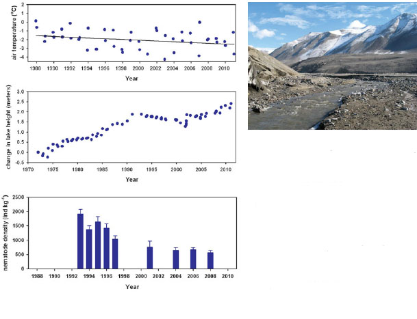
FIGURE 2 Climate variability and ecosystem response in the McMurdo Dry Valleys. Top: midsummer (December-January) surface air temperature, 1988-2011. Middle: change in height of Lake Bonney surface, relative to 1972. Bottom: changes in density of soil nematodes at Lake Hoare, 1993-2008. SOURCES: See Doran et al. (2002) for details and sources. Plots constructed using data from McMurdo Dry Valleys Long Term Ecological Research project (http://www.mcmlter.org/data_home.htm). Photo: High flow of glacier runoff during summer melting event. Courtesy A. G. Fountain.
snow and ice-free areas. These areas range from biologically more complex terrestrial ecosystems on the Antarctic Peninsula and “oases” near the East Antarctic coast to the less complex ecosystems in the McMurdo Dry Valleys (Fox et al., 1994). On both land and sea, warming and ice melt will increase the area of exposed surfaces, provide new habitats for colonization by organisms, and cause changes in ecosystem functioning. As sea ice disappears, new areas of ocean surface will be exposed to increased solar radiance, and biological productivity may increase. Natural colonization rates will increase and species ranges will expand. Rapid expansion of the biogeographical ranges of native plant species has been noted in maritime Antarctica, as have increases in biological production in continental lakes.
These changes in range expansion and growth rates of native species due to warming could lead to fundamentally different organization of Antarctica’s ecosystems, including more complex ecosystem structures, and an increase in the biotic factors (predation, competition, pathogens) that control rates of biogeochemical processes rather than the current dominance by physical factors (National Research Council, 2010b). Understanding current distributions of native species is central to detecting and predicting the effects of climate change. Fortunately, there has been significant progress in identifying some species and the factors that determine their ranges, which can be used to predict future range expansions, new community assembly, and altered ecosystem function.
Questions for the Future
The mechanisms of ecosystem response to global change remain controversial (Trivelpiece et al., 2011), but there is a growing consensus that climate change generally affects ecosystems by destroying existing habitats or enabling new ones (see above) and by disrupting the trophic and other phenological connections among prey and predator populations. Evidence for the effects of climate change on the structure and function of marine, freshwater, and terrestrial systems is still based on a few observational ecological studies and even fewer laboratory and field manipulation experiments (National Research Council, 2011d). Advances in knowledge of the structure and function of Antarctic ecosystems have been substantial, yet researchers are still unsure of the spatial and temporal variability of ecosystem responses to climate change and other global changes. Major questions related to environmental change include the following:
• How vulnerable or resilient are marine, freshwater, and terrestrial food webs to changes such as warming, enhanced water availability, habitat disturbance, ocean acidification, pollutant accumulation, and loss of sea ice?
• What are the functions of Antarctica’s diverse ecosystems in biogeochemical cycling and how will they change?
• Are the marine and terrestrial ecosystems of Antarctica organized differently than ecosystems elsewhere on the globe? And does this temper their responses to change?
• Could Antarctic ecosystems switch to an unknown, alternative state with different structure and functioning?
• Is the Peninsula a harbinger of larger-scale changes to come? Will ecosystems of the continental interior follow the lead of the Peninsula?
Required Tools and Actions
Scientists do not yet know if environmental changes proceed from north to south or from the continental margin to its interior. Lack of geographically extensive, long-term observation records and the paucity of observations south of the Peninsula and McMurdo regions impede rigorous testing of these questions. The fortuitous location of a planetary climate change hotspot in a region with advanced scientific facilities at the many research stations along the Peninsula provides an unparalleled opportunity to understand and predict the future course and consequences of climate change. Meteorological and biotic data needed for model projections also come from long-term observations in lakes, streams, soils, permafrost, and glaciers of the McMurdo Dry Valleys. But there is a dearth of observations at other terrestrial, coastal, and interior sites to indicate the future effects of climate change. To place these local changes in a continent-wide context, and predict the future course of change across Antarctica, a comprehensive coordinated observing and prediction system encompassing all the major elements of the Antarctic environment is needed, including the terrestrial ecosystems, permafrost, surrounding ocean, sea ice, ice shelves, ice sheets, and subglacial habitats. The variables to be captured by a comprehensive Antarctic Observing Network are described later in this report, including geophysical climate observations and coordinated measurements of diagnostic ecosystem structure and biogeochemical function (see Section 4.4).
Antarctica is an international laboratory for studies of global change and ecosystem responses to environmental variability. In the coming decades Antarctica will continue to undergo significant changes due to human activities. Climate change has already altered the ecosystems of the peninsula, and its impacts may well reach across the continent in the coming century. Increased tourism, overfishing, and other human activities will impose new burdens on the management of Antarctica. Moving forward in the coming two decades, it will be increasingly necessary to come to terms with these
possible realities. Yet because of the unity of purpose imposed by the Antarctic Treaty, Antarctica provides the world with the only example of an entire continent reserved primarily for scientific research. A continental-scale, interdisciplinary, observation-prediction-management system will be needed to provide timely data to support decision making, adaptive management, and governance of the continent as the press of human intervention on its climate, natural resources, ecosystems, and biogeochemical cycles becomes ever more intense.
The committee’s vision for science in Antarctica in the next two decades is an integrated observing, information, and modeling effort enhanced by powerful new genomic tools, geochemical tracers, and increased modeling efforts to build a predictive understanding of ecosystem response to rapid climate change.
2.4 WHAT ROLE HAS ANTARCTICA PLAYED IN CHANGING THE PLANET IN THE PAST?
Global Context
The interaction between solid Earth tectonics and the changing planet is complex, multifaceted, and tightly connected. On a very long timescale, the movements of tectonic plates (where plates may consist of entire continents and ocean basins), their fragmentation, or the collision of several plates have dramatic consequences. Consequences range from earthquakes and volcanoes to the construction of new mountain ranges, the opening of gateways between vast oceans, and the triggering of global climate shifts. New mountain ranges provide the high topography where glaciers first grow—glaciers that can become the nucleation point for major ice sheets.
In Antarctica these tectonic processes have driven the uplifting of vast reaches of Earth’s surface, producing spectacular mountain ranges such as the Transantarctic Mountains that cut across the continent and the Gamburtsev Mountains that are hidden completely beneath the thick cover of the East Antarctic Ice Sheet (Figures 2.12 and 2.13). The tectonic and glacial histories of Antarctica are tightly linked. Without its high topography, the history of the Antarctic ice sheet would have been quite different. Without the continental glaciation the mountains of Antarctica would have been quite different. Understanding the mechanisms and timing of the formation of these mountains is linked to the understanding of the changing climate of Antarctica and of the planet in the past.
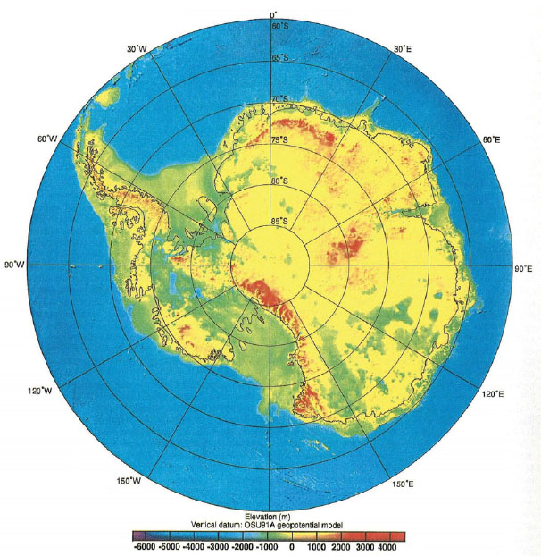
FIGURE 2.12 The tectonic processes that lead to the formation of mountain ranges seen here are linked to the glacial histories of Antarctica.
SOURCE: Bedrock elevations relative to sea level from Lythe et al., 2001.
What Is Currently Known About Antarctica’s Geologic History?
The tectonic opening of key oceanic passageways has controlled global climate and shifted global circulation patterns within the atmosphere and the deep oceans. Over 200 million years ago, Antarctica was the centerpiece of the Gondwana, a massive
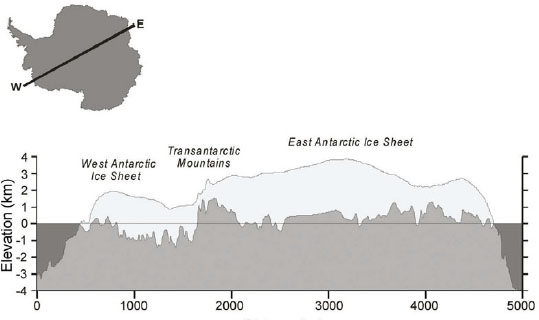
FIGURE 2.13 Cross-sectional profile of the Antarctic ice sheet based on BEDMAP bed topography (Lythe et al., 2001) and surface topography (Liu et al., 1999). The inset indicates the location of profile end points.
SOURCE: G. Clarke; NRC, 2007a.
supercontinent consisting of what later became Antarctica, India, Australia, South America, and Africa. Around 180 million years ago, this supercontinent began to break apart, and Antarctica commenced moving into its present polar position. The climate of the planet was significantly different when Antarctica arrived at the South Pole (roughly 100 million years ago). Because of thick ice, there is no knowledge of the geology of most of East Antarctica, but outcrops at the Transantarctic Mountains and along the Antarctic Peninsula, for example, show that at that time lush forests grew there and were inhabited by dinosaurs and mammals (Francis et al., 2008). With the final separation of the supercontinent and the 10-fold drop in global atmospheric carbon dioxide (CO2) levels from 3,000 parts per million (ppm) in the Cretaceous, to around 500 ppm approximately 34 million years ago, both Antarctica and the globe cooled (Arthur et al., 1988; Jenkyns et al., 1994; Kuhnt et al., 1986). As a seaway formed between South America and Antarctica between 34 and 24 million years ago, the isolation of the southern continent began (see Figure 2.14). The Antarctic Circumpolar Current (see Box 2.4) began circulating and likely reduced the amount of heat that the ocean previously brought from the midlatitudes to the edges of Antarctica. Thus, tectonic fragmentation and falling CO2 levels shifted Antarctica from a green continent to a white continent encased in ice. Understanding the opening of the Southern Ocean

FIGURE 2.14 This figure illustrates (left) the Gondwana supercontinent, (middle) the transition and opening of the oceanic passageway around Antarctica, and (right) present-day geography and bathymetry.
SOURCE: ODSN-Geomar.
as Gondwana fragmented is critical to understanding how Antarctica became glaciated and why the global climate became much colder. Researchers have learned much about the processes of past climate change from Antarctic sediment and ice cores. The Antarctic ice cores provide key insights into past changes in the global atmosphere while sediment cores reveal how the ice sheets have waxed and waned in the past (see Section 3.1). This information is crucial to constraining global climate models of the past and of the future.
While ice sheets mantle the entire Antarctic continent and the most dramatic environmental change is being observed along the edges, the crucial location for understanding the mechanisms of how these thick, slow-moving, enormous pieces of ice will change is the interface between the ice and the underlying rock. The presence of water or water-saturated sediments acts as a lubricant to the ice sheet, enabling ice to slide from the center of the continent to the ocean. Subglacial lakes (National Research Council, 2007a) usually formed in rifted basins and are linked to the onset of fast ice flow (National Research Council, 2007a). Tectonically driven heat flow variations are key controllers of basal melting rates and the distribution of subglacial water. Knowledge of the basal conditions—what is happening beneath the ice where ice meets water or solid rock and sediment—is key to understanding ice sheet dynamics and how the ice sheets will move.
Questions for the Future
Projections of future Antarctic ice sheet dynamics depend heavily on acquiring knowledge of what lies below that ice, including the physical properties of the ice column and the properties of ice-rock and ice-sediment interfaces. Constructing useful models of ice sheet and shelf movements to estimate their potential for destabilization will depend on obtaining major expansions of core sampling, annual ice budget measurements, and ice sheet velocity mapping. Without carefully defining basal conditions, especially with respect to how slippery the beds are and how much melt is present at the base of each ice sheet, ice sheet models will not be able to produce reliable estimates of how the ice sheets will change in the future. Contemporary estimates of continental ice movements are shown in Figure 2.15.
Required Tools and Actions
Understanding the role Antarctica has played in global systems over time will require a holistic study of both the thick ice sheets and the underlying Earth crust. Major gaps remain in the fundamental knowledge of the structure of the Antarctic continent. Determining how the continent was formed is one key to understanding the role Antarctica has and will play in the global system. Studies of the base of the ice sheet will require sampling through the thick ice and should include accurate measurements of heat flow. Projections of future changes suggest that warm ocean waters will eventually reach the margins of East Antarctica, an ice sheet that presently appears relatively stable. Key approaches include systematic surface and airborne geophysical observations in both East and West Antarctica along with sampling of the rock beneath the thick mantle of ice. Both studies of the fundamental architecture of the Antarctic continent and essential ice sheet dynamic studies will require airborne radar and laser observations from long-range aircraft complimented by coincident gravity and magnetic field measurements. Sampling the base of the ice sheet and the underlying bedrock requires development of a new generation of rapid drilling systems for access to the bed with minimal contamination of the environment. While much emphasis has been placed on the apparent instability of portions of the West Antarctic Ice Sheet, much of East Antarctica remains absolutely unknown yet is critical to the understanding of the continent and the ice sheets. Regions to be sampled include the enigmatic Gamburtsev Mountains, subglacial lakes, and other major subglacial provinces. Marine drilling targets range from the Weddell Sea coast to new sites in the Ross Sea. Dynamic drilling programs including the Integrated Ocean Drilling Program and Antarctic Geological Drilling have been very effective at determining the climate history of Antarc-
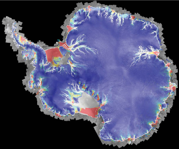
FIGURE 2.15 Composite surface speed of ice from RADARSAT-1. Speed is represented by a color log 10 scale (0 in deep blue to 1,000 m/yr in red). This type of information is crucial to develop reliable ice sheet models.
SOURCE: Jezek, 2008.
tica. Ongoing marine geophysical studies of the surrounding oceans including high-resolution marine bathymetry, and marine seismic measurements will be important to examine the mechanisms and timing of prior major tectonic events.
Initiatives to expand knowledge of the geology and glaciology of Antarctica through collaborative international efforts have already begun (Bell, 2008). However, the large scale of the necessary observations and the observing network remains daunting considering the difficult task of diagnosing and monitoring the motions and melting of an ice and land mass that is approximately 1.4 times the area of the United States (British
Antarctic Survey, 2005). In parallel with major advances and expansions in sampling networks, advanced mathematical modeling with understanding of the basic fluid mechanics of the continental ice sheet is needed. Validation activities based upon actual sampling of the ice sheet’s properties would improve these models.
In 20 years, the committee envisions that there will be an improved understanding of the tectonic evolution of Antarctica, including the formation of the major mountain ranges, the distribution of key geologic terrains beneath the ice sheets, and the opening of major ocean basins surrounding the continent. Understanding tectonic evolution will inform the understanding of the basal geologic framework and the conditions necessary for developing accurate ice sheet models.
This page intentionally left blank.
Red lights help maintenance workers doing routine repairs on the South Pole Telescope.
SOURCE: Daniel Luong-Van/NSF.


