
Monitoring and Assessment of GNSS Open Services
JIAO WENHAI
Beijing Institute of Tracking and Telecommunication Technology
DING QUN
Xi’an Research Institute of Navigation
LI JIAN-WEN
Zhengzhou Institute of Surveying and Mapping
LU XIAOCHUN
National Time Service Center
FENG LAIPING
Xi’an Research Institute of Surveying and Mapping
Interoperability of GNSS Open Services has already been a significant tendency in developing all satellite navigation systems, and its performance will directly affect the security and reliability of its usages. Therefore, monitoring and assessment of GNSS Open Services have become a focus of attention for all providers and users of GNSS. This paper begins to illuminate the elements and methods for monitoring and assessing GNSS Open Services. Then according to the requirements, the architecture of an international GNSS Monitoring and Assessment System (iGMAS) is designed to achieve the 4-overlap and 1-overlap coverage and sophisticated analysis, respectively. Here, this iGMAS is based on omnidirectional antennas, multi-beam antennas, and a high-gain paraboloid antenna. In the meantime, the configuration scheme of worldwide monitoring stations is provided. Finally, some related works that have been done to monitor and assess the BeiDou Open Service are introduced that can be used to verify the feasibility of this proposed system.
INTRODUCTION
Stepping into the 21st century, because of the successful launches of the BeiDou and the Galileo satellites, the GNSS is changing from the bipolar competition situation between GPS and GLONASS to a new situation of competition and cooperation among four systems. Obviously, the compatibility and interoperability of navigation signals have already been the main features during the period of GNSS development. Against this background, open signals, with the function of interoperability, are expected to bring GNSS services of higher quality and better performance to GNSS users, especially in such places as urban canyons and mountainous areas where visual airspace of satellite is limited. Open signals can bring a significant increase in the number of visible navigation satellites, improving the reliability and availability of navigation and positioning services (Yang, 2010). So far, the main existing and being designed signals of GNSS Open Services are as shown in Table 1.
At present, the four satellite navigation systems have issued or are planning to issue their own specifications on open service performance. However, because of the diversity in their respective conditions and knowledge, there may be large differences in those specifications, either in form or in performance. As a result, users will get confused when they are using and it will be inconvenient for them to use. In addition, there are no performance specifications on GNSS open service signals. To ensure the safety of the usage and achieve the ultimate goal of interoperability of GNSS Open Services signals, it is essential for us to research the monitoring and assessment of GNSS Open Services.
Monitoring and assessment of GNSS Open Services could provide third-party information on performance for a single system and reliable decision-support
TABLE 1 Signals of GNSS Open Services
| Global Navigation Satellite Systems | Frequency | Center Frequency (MHz) | Modulation Mode | Interoperable or Not |
| GPS | L1 C/A | 1575.42 | BPSK(1) | |
| L1C | 1575.42 | MBOC(6,1,1/11) | Yes | |
| L2C | 1227.6 | BPSK(1) | ||
| L5C | 1176.45 | QPSK | Yes | |
| GLONASS | L1OF/L1OCM | 1598.06~1604.40 | BPSK | |
| L2OF/L1OCM | 1242.94~1248.63 | BPSK | ||
| L3 OC | 1202.025/1207.14 | BPSK | ||
| BeiDou | B1-C | 1575.42 | MBOC(6,1,1/11) | Yes |
| B2a | 1191.795 | AltBOC(15,10) | Yes | |
| B2b | ||||
| GALILEO | E5a | 1191.795 | AltBOC(15,10) | Yes |
| E5b | ||||
| E1 | 1575.42 | MBOC(6,1,1/11) | Yes | |
information for users when they are using its service, to minimize possible adverse effects and to improve quality of service. On the other hand, based on compatibility and interoperability, the GNSS system can bring not only a great leap in improved performance and quality of navigation service, but also large degradation due to signal interference problems between systems. Carrying on the monitoring and assessment of GNSS Open Services can help to deal with these problems. It can enhance the reliability of open service on one hand, and, on the other hand, from the standpoint of system monitoring and assessment on the comprehensive properties of multi-system open services, could improve compatibility and interoperability performance between each system, providing decision-support information for maintenance and management of the multi-system.
Since 1997, Stanford University has been under contract to support the U.S. GPS Joint Program Office by regularly monitoring the L-band transmissions of all newly launched and currently operational GPS satellites. The goal of this program is to verify that all deployed satellites are consistently and reliably performing according to the specifications. Stanford University has been measuring the signal power, code delay, frequency content, and bandwidth to verify the proper operation of satellite constellations. Currently, Stanford University is upgrading the RF and data-collection systems at a 47 m- (150 ft-) diameter steerable antenna (“The Dish”) that has been used to collect these measurements. Meanwhile, it can also monitor and analyze other countries’ satellite navigation systems.
In September 2005, the Institute of Communications and Navigation of the German Aerospace Center (DLR) established an independent monitoring station for analyzing GNSS signals. The core of this facility is a 30-m deep space antenna located at DLR ground station at Weilheim, Germany. The integrated measurement system fulfills the highest quality standards to obtain high-accuracy measurements from raw data of GNSS signals to perform precise analyses. After the commissioning phase of SVN49, relative data were collected in order to provide a basis for analyzing the signal anomaly. After the SVN49 signal anomaly was first noticed by this monitoring station, they started a detailed investigation of this issue using the high-gain antenna.
Stanford and the DLR have already formed the cooperation mechanism for joint monitoring and assessment of GPS and Galileo signals.
ELEMENTS AND METHODS FOR MONITORING AND ASSESSING GNSS OPEN SERVICES
The work of monitoring and assessing of GNSS Open Services can be divided into the following layers: constellation state layer, spatial signals layer, navigation information layer, and service performance layer. Before choosing and determining the elements and methods of assessment, we should, in the sight of different users’ requirements, take into comprehensive consideration organic connections between different layers, as well as characteristics of independent elements. So
the independence of open services for a single system cannot be neglected in front of multi-systems. Those finally determined elements and methods should be open, extensible, and compatible. So when a new system and its open signals appear, this monitoring system can analyze them as well. In addition, the function and role of third-party monitoring cannot be fulfilled unless real-time monitoring and real-time release are emphasized when monitoring and assessing GNSS Open Services.
Constellation State
Constellation state is one of the decisive factors for satellite navigation systems to realize their service performance. So real-time monitoring and assessment play a significant role for the users to use open services safely and reliably. Monitoring and assessment of the constellation state include the following content.
Constellation State
Constellation state refers to the working state of a single satellite or that of each satellite in GNSS constellation at a particular moment. Common working states can be divided into normal working state, testing and maintenance state, fault state, etc. The number of satellites in various states and their orbit distributions are used to describe those working states. In addition, such features as the launch date and service life of each satellite can also be used as a reference in assessing satellite state. Besides, information on constellation malfunction, maintenance, and management released alone by each satellite navigation system is also an important source of information for monitoring and assessing constellation conditions.
Constellation DOP
Constellation DOP indicates values of various DOPs of healthy satellites in their service range in a single or GNSS constellation, including GDOP, PDOP, HDOP, VDOP, TDOP, etc. As an influence factor of satellites geometry distribution on the error of navigation, positioning, and timing, DOP can be a comprehensive reflection of the geometry distribution and health condition of constellations. As for single-system constellations, instantaneous DOP is the most direct indicator for assessing performances. When it comes to multi-system constellations, instantaneous DOP can also be used as an important reference indicator for assessing the navigation and positioning performance of interoperable open signals.
Number of Visible Satellites
The number of visible satellites is still an important indicator for assessing the space-time condition of constellations. Its instantaneous value has a strong dependence on instantaneous DOP, whether it is a constellation of a single system or multi-systems. As the interoperability of GNSS Open Services comes true, the availability of more visible satellites will definitely reduce the sensitivity of a single satellite to service performance and improve observations redundancy at the same time. As a result, the precision, reliability, and availability of their services can be improved greatly.
Spatial Signals
To assess the quality of GNSS spatial signals, relative assessment experiments should be taken from time domain, frequency domain, modulation domain, and correlation domain.
Time Domain Characteristics
To obtain baseband signals, those digital intermediate frequency signals collected by a high-gain antenna should be conducted by quadrature carrier stripping and Doppler removing using a software receiver. Then we can draw time domain waveforms. And based on these, some characteristics such as the edge shape of one chip, code sequence, code rate, code shape, degree of digital distortion and analog distortion, etc. could be analyzed in detail (Hegarty and Ross, 2010). Besides, eye diagrams of actual signals and ideal signals could be displayed on the same graph to observe their similarity. In the meantime, related parameters of eye diagrams, for example, open degree and noise tolerance, etc., can be calculated. Thus we can assess the quality of received signals from time domain properties.
Frequency Domain Characteristics
Frequency domain characteristics are analyzed mainly with offline analysis software, assisted by some standard measuring instruments such as a real-time spectrum analyzer and so on. Through the test on signals from such aspects as carrier frequency, power spectrum and its envelope, bandwidth and center frequency, beamwidth between two zero point on main lobe, etc., we can see the difference of power spectrums between actual signals and ideal signals. In addition, some other indicators such as spectrum asymmetry or distortion, signal stray, and carrier leakage, etc., can be assessed comprehensively. Thus we can assess the quality of received signals from frequency domain properties.
Modulation Domain Characteristics
Both signal vector diagram and histogram are analyzed in detail mainly with offline analysis software, assisted by some standard measuring instruments such as a vector signal analyzer and so on. Using offline analysis software, vector diagrams of received signals can be drawn, with that of ideal signals in the same diagram. Then we can easily compare these two vector diagrams. Besides, error vector diagram can be constructed to extract indicators such as the phase orthogonality, carrier orthogonality, amplitude imbalance of I/Q channels, etc. In this way, phase error and amplitude error caused by channel distortions and noise interference and so on could be analyzed. In addition, histograms drawn by offline analysis software can be used to assess noise level. Using a vector signal analyzer, a signal vector diagram can be drawn, with its center frequency offset, SNR, EVM value, etc. shown on the screen. We can also see its stability by root-mean-square deviation calculated by this analyzer.
Correlation Domain Characteristics
Correlation domain characteristics of received signals are analyzed mainly from aspects such as the correlation curve, correlation loss, curve symmetry, code delay, and S curve deviation of DLL discriminator, etc., by offline analysis software (Lu and Zhou, 2010). The correlation curve of received signals is compared with that of ideal duplicated code sequences to see its asymmetry and false lock probability. Thus we can assess the degree of correlation distortion caused by band limited filter, noise, multipath, cross-correlation, etc.
Navigation Information
Navigation information refers to those parameters such as satellite constellation, satellite clock correction, ionosphere delay, time system deviation, etc., that are provided by a satellite navigation system. It is the most important factor that affects system service performance and is one of the most important factors for monitoring and assessing GNSS Open Services signals.
Message Validity
The verification of navigation message validity includes the following two points—consistency verification and the rationality and validity verification. As for consistency verification, various parameters such as time information, constellation, satellite clock, ephemeris, correction information, and so on are verified to see if they are set and updated correctly according to the ICD file. In the period of rationality and validity verification, it is necessary to determine according to the specific attribute and generation method of each parameter.
Accuracy of Ionosphere Delay Correction
Model parameters of ionosphere delay correction are very important to single-frequency users. Those ionosphere models and parameters in each satellite navigation system are far from different. Accuracy of ionosphere delay correction has a close relation not only with model types but also with accuracy and update frequency of parameters. It can be assessed by obtained values of ionosphere delay using double-frequency or multi-frequency pseudorange observations.
Accuracy of GNSS Time Deviations
GNSS time deviation reflects the deviations among timing biases of each satellite navigation system. It is important basic data to realize GNSS compatibility and interoperability. And its accuracy will directly affect the PVT calculating precision for various GNSS user equipments, especially for timing equipments. So monitoring GNSS time deviations has more requirements for equipment to get more reliable external accuracy.
Validity of Deviation Parameters Between Different Frequencies
Monitoring of deviation parameters between different frequencies contains the following two parts. One is the time deviations of different frequency signals when passing through satellite-borne equipments; these deviations have something to do with the calibrated values and signal frequency. The second is the time deviations among different modulated codes for the same carrier, known as the phase consistency between carrier and pseudo-code.
Service Performance
Satellite navigation systems provide three kinds of basic services—positioning, velocity measuring, and timing (PVT)—for all types of users. Its service performance is commonly described by such indicators as precision, availability, integrity. and continuity (DOD, 2008).
Precision
The precision of spatial signals includes URE, URRE, URAE, and UTE. It is an important indicator to assess the effect of satellite ephemeris and forecasted clock deviation on the error of positioning, velocity measuring, or timing. To assess the precision of signals, it is necessary to calculate the precise orbits and clock deviation afterwards.
Service precision is used to describe the deviation between measured value and the ideal value of positioning, velocity measuring, or timing for system
users. It equals UERE multiplied by DOP, where UERE is determined by URE (User Ranging Error) and UEE (User Equipment Error). UERE can be calculated from the expression ![]() , and it is dependant on errors of satellite atomic clock, ephemeris, atmosphere model, multipath effect, receiver clock deviation, etc.
, and it is dependant on errors of satellite atomic clock, ephemeris, atmosphere model, multipath effect, receiver clock deviation, etc.
Availability
Service availability refers to the time percentage when the error of positioning, velocity measuring, or timing can meet the required threshold in a period of time (a return cycle) and in a specified service area. According to the expression that precision equals UERE multiplied by PDOP, service availability can be changed to DOP availability when setting UERE.
Integrity
Service integrity mainly refers to the probability for a navigation system to provide a timely alarm within the limited period when the error of its positioning, velocity measuring, or timing is larger than the threshold. It is generally expressed by alarm threshold, alarm time, and hazard misleading information (HMI), where alarm time refers to the maximum time delay allowed from the time a malfunction starts to the time an alarm generates. In addition, HMI probability refers to the dangerous probability when the current measured value falls in the range of alarm threshold.
Continuity
Service continuity refers to the time percentage when a satellite navigation system can continuously meet required service precision in a period of time and specified service area. The average continuity of service can be calculated according to MTBF (Mean Time between Failures) and MTTR (Mean Time to Repair) under the condition of the satellite’s unplanned interrupt.
FRAMEWORK OF IGMAS
Architecture and Functions
To monitor and assess GNSS Open Services worldwide, it is very necessary to construct an iGMAS. The basic functions of iGMAS should include data monitoring and collecting, data transmitting, data storing, data analyzing, and information release. Figure 1 shows its architecture.
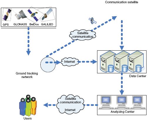
FIGURE 1 Framework of iGMAS.
Data Monitoring and Collecting
Data monitoring and collecting refers to the collecting and measuring of GNSS navigation signals, in addition to the collecting of environmental observation data (such as electromagnetic data, meteorological data). The main functions include:
- Providing 4-overlap coverage observations for integrity monitoring and precise orbit determination.
- Real-time monitoring on the quality of all GNSS satellite signals using digital multi-beam antennas and related equipment.
- Realizing continuous and sophisticated observations on key satellites using a 30-m high-gain antenna and related equipment.
Equipment for monitoring and data collecting mainly includes anti-multipath omnidirectional antennas, multi-beam antennas that can receive all GNSS signals in the visible world (with equivalent diameter of 2.4 m and gain of 28 dB), a 30-m
antenna, monitoring receiver, RF observations collecting equipment, baseband signal collecting equipment, delay calibrating equipment, meteorological sensing equipment, and electromagnetic environment analyzing equipment. Some other auxiliary equipment includes atomic clocks, data processor, network switches, etc.
Data Storing
Basic tasks of data storing include the classifying, storing, and management of monitored and collected data, and analyzing results, other data, or information, etc.
There are some data transmission links such as the Internet, satellite link (VSAT), and wireless mobile communication network, etc.
Data Analyzing and Information Release
Data analyzing and information release refers mainly to the classifying and processing of GNSS monitoring data. That means comprehensive analysis of GNSS signals and information to assess its service performance. For example, analyzing constellation characteristics such as the number of visible satellites, constellation state, and constellation DOP; analyzing navigation signal properties from time domain, frequency domain, modulation domain, and correlation domain; verifying the validity of navigation information, such as navigation message, accuracy of ionosphere delay correction, accuracy of GNSS time deviations, validity of time deviation parameters between different frequencies; and assessing the precision, availability, integrity, and continuity of GNSS Open Services. And, in the meantime, the release of statistical information on the working states of GNSS satellites to users based on those comprehensive analysis results. Here the equipment required includes real-time states displaying equipment, analyzing, and assessing software, servers, working stations, network exchanging equipment, mass storage, etc.
Data Transmission
Basic tasks of data transmission include data exchanging, control instruction transmission, and transmitting released information to users.
There are some data transmission links such as the Internet, satellite link (VSAT), and wireless mobile network, etc.
Tentative Plan of iGMAS Implementation
Preliminary Configuration Scheme
In iGMAS, those tracking stations scattered worldwide are used to implement data collecting. There are mainly two factors in considering their configuration:
- To achieve signal-quality monitoring, it is necessary to use multi-beam antennas and a 30-m high-gain antenna to track satellites continuously. So at least those tracking stations should meet the requirement of 1-overlap coverage of satellites.
- To achieve satellite-integrity monitoring, those tracking stations should meet the requirement of 4-overlap coverage of satellites.
Here the tracking stations are selected from existing IGS stations, and a grid-analysis method is used to optimize their layout (Stanton and Strother, 2007), with the analysis range between 65° N and 65° S and the height of 19,000 km. Those grids are divided into 1°*1° with the height angle’s deadline of 15°.
To meet the two requirements described above, preliminary analysis results shows that 6 tracking stations and 24 stations are needed. In Table 2, we can see the locations of iGMAS tracking stations. Two kinds of optimal design methods for 1-overlap coverage and 4-overlap coverage are shown in Figures 2 and 3, respectively.
Operational Mode
Here the iGMAS can be constructed through international cooperation among providers and global civil users of the four global navigation systems.
The basic unit of iGMAS is called a node. Nodes can have five functions of data collecting and monitoring, data transmitting, data storing, data analyzing, and information release.
All nodes can be divided into three levels. Level one has all the five functions described above; level two has functions like data collecting, transmitting,
TABLE 2 Locations of iGMAS tracking stations
| Name | Location | Name | Location |
| BEIJ* | China | MAS1 | Spain |
| PERT* | Australia | BAHR | Bahrain |
| RCMN* | Kenya | ONSA | Sweden |
| LPGS* | Argentina | SANY | China |
| CAGS* | Canada | IRKT | Russia |
| TAH1* | France | WLMQ | China |
| CHAT | New Zealand | NOUM | France |
| KOKB | America | KERG | France |
| COSO | America | HART | South Africa |
| FAIR | America | CAS1 | Antarctic |
| BOGT | Colombia | OHI3 | Antarctic |
| FORT | Brazil | KELY | Greenland |
| * Denotes those tracking stations belonging to both 4-overlap and 1-overlap coverage. | |||
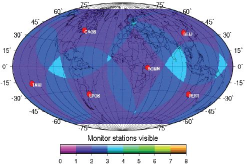
FIGURE 2 Optimal design of 1-overlap coverage stations.
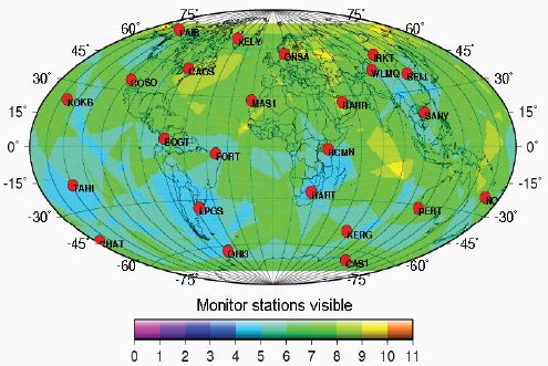
FIGURE 3 Optimal design of 4-overlap coverage stations.
storing, and analyzing; level three has only two functions of data collecting and transmitting. To realize the goal of data sharing, each node provides data to the net while automatically extracting data from it to perform signal assessing. All nodes in level one will join together to realize the monitoring and assessment of GNSS Open Services and information release. The net can work regularly through the collaborative work of its nodes, which can access or exit the net freely.
PERFORMANCE MONITORING AND ASSESSING FOR BEIDOU SYSTEM
Precision Monitoring and Assessing of Spatial Signals
To monitor and assess the performance of BeiDou open services from the information layer, a BeiDou monitoring and assessment system was built successfully in November 2007. It consisted of a monitoring and assessment center, one data analyzing center, and six tracking stations. The tracking stations were located in Xi’an, Shanghai, Changchun, Kunming, Urumqi, and the Antarctic, with each station equipped with BeiDou measuring receivers, high-precision atomic clocks, and computers, etc. The goal was to calculate the precise orbits and clock deviation of BeiDou navigation satellites, to assess the performance of satellite clocks and parameter accuracy of ionosphere models, and to verify the validity and rationality of navigation message, etc.
Quality Monitoring and Assessing of Spatial Signals
In February 2009, the first BeiDou signal-quality monitoring and assessment system was built successfully by NTSC, Chinese Academy of Sciences, in Lintong district of Xi’an, Shaanxi province. This system consisted of a 7.3-m antenna, an RF receiving subsystem, an RF observational data-collecting subsystem, a baseband signal-collecting subsystem, monitoring receivers, a calibrating subsystem, a data storing subsystem, and so on. Obtained results showed that this system could achieve some deeper tasks of GNSS signal-quality monitoring and assessment using many standard measuring instruments, monitoring receivers, high-speed data collecting equipments, and offline analysis software.
At present, two key technologies of GNSS signal-quality monitoring and assessment, that is, offline technology for analyzing signal performance based on correlation curve and channel calibrating technology, have strived to make important technological breakthroughs, while the anti-interference technology has also made much progress. Since its successful running in April 2009, this system has completed successfully signal-quality monitoring and assessment for BeiDou GEOs and IGSOs. In the meantime, it has also collected and analyzed GPS MEOs signals and Galileo Glove-B signals.
CONCLUSIONS
Monitoring and assessment of GNSS Open Services can bring much benefit to the healthy development of GNSS. It can not only extend the depth and breadth of GNSS applications, but also provide the foundation for all kinds of civil users to use system services safely and reliably. There is sufficient evidence to show that the iGMAS proposed in this paper is technically feasible. For example, the preliminary exploration of BeiDou in its open services monitoring and assessment, the long-term successful operation of IGS, and achievements in navigation signal monitoring and assessment made by Stanford University and DLR, etc. However, the construction of iGMAS is a global and long-term work, and it needs more organizations and countries to be involved. So it is very necessary to implement international cooperation.
REFERENCES
DOD (U.S. Department of Defense). 2008. Global Positioning System Standard Positioning Service Performance Standard. Available online at http://pnt.gov/public/docs/2008/spsps2008.pdf.
Hegarty, C.J., and J.T. Ross. 2010. Initial Results on Nominal GPS L5 Signal Quality. Pp. 935–942 in Proceedings of the 23rd International Technical Meeting of the Satellite Division of the Institute of Navigation (ION GNSS 2010), Portland, Oregon, September 2010.
Lu, X.C., and H.W. Zhou. 2010. Methods of analysis for GNSS signal quality (in Chinese). Scientia Sinica Physics Mechanics and Astronomy 40(5): 528–533.
Stanton, B.J., and R. Strother. 2007. Analysis of GPS Monitor Station Outages. Pp. 176–183 in Proceedings of the 20th International Technical Meeting of the Satellite Division of the Institute of Navigation (ION GNSS 2007), Fort Worth, Texas, September 2007.
Yang, Y.X. 2010. Progress, contribution and challenges of Compass/BeiDou satellite navigation system (in Chinese). Acta Geodaetica et Cartographica Sinica 39(1): 1–6.


