National Academy of Sciences | 150 Year Anniversary

Questions? Call 800-624-6242

| Items in cart [0]

The National Academies Press

PAPERBACK
price:$65.00
add to cart

Rights & Permissions

topleft topright

Global Navigation Satellite Systems: Report of a Joint Workshop of the National Academy of Engineering and the Chinese Academy of Engineering (2012)

Citation Manager

. "Impact of Intentional, Low Power, In-Band, Personal Privacy Devices (PPDs) on Aviation--A.J. Van Dierendonck." Global Navigation Satellite Systems: Report of a Joint Workshop of the National Academy of Engineering and the Chinese Academy of Engineering. Washington, DC: The National Academies Press, 2012.

Please select a format:

BibTeX EndNote RefMan


Page
147
bottomleft bottomright

The following HTML text is provided to enhance online readability. Many aspects of typography translate only awkwardly to HTML. Please use the page image as the authoritative form to ensure accuracy.


Global Navigation Satellite Systems

Impact of Intentional, Low Power, In-Band, Personal Privacy Devices (PPDs) on Aviation

A.J. VAN DIERENDONCK
AJ Systems
Los Altos, California

What are PPDs? PPDs are small “jammers” that plug into cigarette lighter sockets that are meant to “jam” or “mask” Global Positioning System (GPS)-Global Navigation Satellite Systems (GNSS) receiver/navigators that report, through other means, the position of the host vehicle, when the user does not want his position known. Use is illegal in the United States. They are probably purchased via the Internet. Unknown (or known) to the owner, PPDs can jam other users of GPS (GNSS), including Safety-of-Life (SOL) operations. At Newark, New Jersey, airport (EWR), such a device’s radio frequency interference (RFI) affected the Ground-Based Augmentation System (GBAS) operation. GBAS performance interruptions have been observed since November 2009, impacting GBAS service availability, although there was no evidence of direct effects on airborne avionics. It was determined that RFI emanated from sources on the New Jersey Turnpike (NJT) (in motion). A test program determined direction of travel, average velocity, how frequently emitter(s) traveled past the EWR GBAS, and what time of day and days of the week events were observed.

RFI was also detected at Wide Area Augmentation System (WAAS) Reference Stations (WRSs) near Washington, D.C., and Houston, Texas. However, because of diverse location and redundancy of WAAS reference receivers, no interruptions of WAAS operations were noticed.

RFI was characterized by analyzing data collected from GPS receivers, spectrum analyzers, and time samples captured by real time data collection (snapshots). Through measurements of spectral shape, time series demodulation, magnitude of degradation in GPS receivers, and estimates of emitter(s) transmitted

Page
147
Front Matter (R1-R16)
Summary of the Workshop--As Reported by Grace Xingxin Gao (1-10)
Address at the Opening Ceremony of the NAE-CAE Joint Workshop on Global Navigation Satellite Systems (GNSS)--Zhou Ji (11-12)
Introductory Remarks--Charles M. Vest (13-14)
WORKSHOP PRESENTATIONS (15-16)
Development of the BeiDou Navigation Satellite System--Ran Chengqi (17-24)
U.S. GPS Policy, Programs, and International Cooperation Activities--David A. Turner (25-34)
Research Report on GNSS Interoperability--Lu Xiaochun, Lu Jun, Bai Yan, Han Tao, and Wang Xue (35-74)
The Interchangeability Problem: Signals, Coordinate Frames, and Time--Rita M. Lollock, Thomas D. Powell, and Thomas A. Stansell (75-82)
COMPASS/BeiDou Coordinate and Time Reference Systems--Yang Yuanxi, Tang Jing, and Han Chunhao (83-94)
A Global Safety of Life Service from Multiple GNSS Constellations--Per Enge (95-104)
Monitoring and Assessment of GNSS Open Services--Jiao Wenhai, Ding Qun, Li Jian-wen, Lu Xiaochun, and Feng Laiping (105-118)
Alternative Position, Navigation, and Timing: The Need for Robust Radionavigation--Mitchell J. Narins, Leo V. Eldredge, Per Enge, Sherman C. Lo, Michael J. Harrison, and Randy Kenagy (119-136)
Analysis of the GNSS Augmentation Technology Architecture--Chen Jinping (137-146)
Impact of Intentional, Low Power, In-Band, Personal Privacy Devices (PPDs) on Aviation--A.J. Van Dierendonck (147-152)
GNSS Open Signals Interference Issues and Countermeasures--Du Xiaodong, Wang Feixue, and Nie Junwei (153-166)
Present and Future Applications of COMPASS Navigation Satellite System--Tan Shusen (167-178)
Application of GNSS to Environmental Studies--Penina Axelrad (179-188)
Recent Progress on GNSS Seismology--Liu Jingnan, Fang Rongxin, and Shi Chuang (189-198)
Precision Agriculture: Opportunities and Challenges--Michael O'Connor (199-206)
Integrity Lessons from the WAAS Integrity Performance Panel--Todd Walter, Per Enge, and Bruce DeCleene (207-228)
Breaking the Ice: Navigation in the Arctic--Grace Xingxin Gao, Liang Heng, Todd Walter, and Per Enge (229-238)
APPENDIXES (239-240)
Workshop attendees [photo] (241-242)
Appendix A: Workshop Agenda (243-246)
Appendix B: Workshop Summary Record (247-250)
Appendix C: Biographical Information (251-264)
Appendix D: Acronyms (265-268)

Below are the first 10 and last 10 pages of uncorrected machine-read text (when available) of this chapter, followed by the top 30 algorithmically extracted key phrases from the chapter as a whole.
Intended to provide our own search engines and external engines with highly rich, chapter-representative searchable text on the opening pages of each chapter. Because it is UNCORRECTED material, please consider the following text as a useful but insufficient proxy for the authoritative book pages.

Do not use for reproduction, copying, pasting, or reading; exclusively for search engines.

OCR for page 147
Global Navigation Satellite Systems Impact of Intentional, Low Power, In-Band, Personal Privacy Devices (PPDs) on Aviation A.J. VAN DIERENDONCK AJ Systems Los Altos, California What are PPDs? PPDs are small “jammers” that plug into cigarette lighter sockets that are meant to “jam” or “mask” Global Positioning System (GPS)-Global Navigation Satellite Systems (GNSS) receiver/navigators that report, through other means, the position of the host vehicle, when the user does not want his position known. Use is illegal in the United States. They are probably purchased via the Internet. Unknown (or known) to the owner, PPDs can jam other users of GPS (GNSS), including Safety-of-Life (SOL) operations. At Newark, New Jersey, airport (EWR), such a device’s radio frequency interference (RFI) affected the Ground-Based Augmentation System (GBAS) operation. GBAS performance interruptions have been observed since November 2009, impacting GBAS service availability, although there was no evidence of direct effects on airborne avionics. It was determined that RFI emanated from sources on the New Jersey Turnpike (NJT) (in motion). A test program determined direction of travel, average velocity, how frequently emitter(s) traveled past the EWR GBAS, and what time of day and days of the week events were observed. RFI was also detected at Wide Area Augmentation System (WAAS) Reference Stations (WRSs) near Washington, D.C., and Houston, Texas. However, because of diverse location and redundancy of WAAS reference receivers, no interruptions of WAAS operations were noticed. RFI was characterized by analyzing data collected from GPS receivers, spectrum analyzers, and time samples captured by real time data collection (snapshots). Through measurements of spectral shape, time series demodulation, magnitude of degradation in GPS receivers, and estimates of emitter(s) transmitted

OCR for page 148
Global Navigation Satellite Systems power, RFI was characterized. The fact that the interference source was moving complicated the characterization. THE SCENARIO AT EWR NJT runs by the GBAS facilities (Figure 1). There was intermittent severe degradation or loss-of-lock in GBAS reference receivers. There were also additional GPS receivers/antennas installed at the GBAS shelter to record more detailed information when severe GBAS degradation was noted—one antenna with moderate directivity that was pointing horizontal northward along NJT, and one omni-directional pointing up. Of course, received interference power was greatest during the closest approach of the interference source. This resulted in negative elevation angles, so gain was low, but approximate azimuth direction could be observed. The spectral peak of Antenna 1 is observed at GPS TOW1 (GPS Time of Week of event 1); the spectral peak of Antenna 2 is observed at GPS TOW2 (event 2). The average speed is based upon the time difference. Google Earth images of 654 meters at 33° places RFI in the NJT southbound lane 5. 
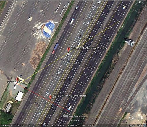
FIGURE 1 The scenario at EWR.

OCR for page 149
Global Navigation Satellite Systems Multiple emitter types were observed (Figure 2). A linear sweep indicates that the underlying signal for this particular event is swept CW, starting at 1570 MHz and increasing to 1590 MHz in about 116 microseconds (8.6 kHz sweep rate). The small increase in the center of the band is GPS coarse/acquisition code. OBSERVED L1 C/N0 DEGRADATION—RFI POWER ESTIMATES Figure 3 presents a histogram of Normalized Measurements of C/N0 (L1 Carrier Power-to-Noise Density ratio) from a WAAS G-II Receiver that was developed covering 146 days. The events were recorded whenever loss-of-lock or severe degradation occurred in the GBAS Reference Receiver. The magnitude of degradation varied more than 20 dB, greater than the uncertainty with respect to Free-Space-Loss (FSL). 
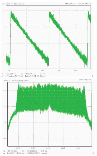
FIGURE 2 Typical wideband RFI.

OCR for page 150
Global Navigation Satellite Systems 
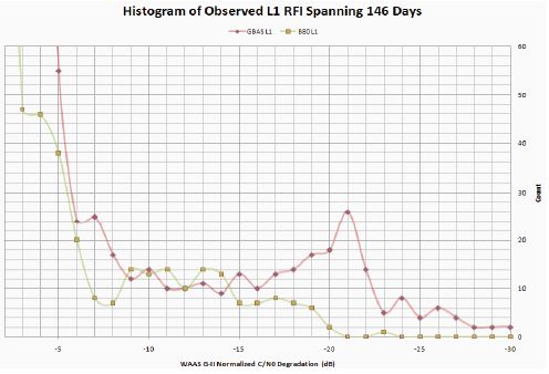
FIGURE 3 WAAS G-II normalized C/N0 degradation (dB). The estimated RFI power variation due to measurement accuracy is minimal—approximately ±1 dB RSS. The estimated RFI power variation due to other uncertainties is significant—transmit antenna gain and the loss exiting the vehicle, and the exact location of RFI transmitter (10 to 11 dB). The polarization mismatch loss uncertainty is 1 to 6 dB. Note that most of the degradations were less than about 8 dB, but a significant number had a degradation of 21 dB. THE SCENARIO NEAR WAAS REFERENCE STATIONS AT LEESBURG, VIRGINIA, AND HOUSTON, TEXAS Figure 4 shows a scenario near the WAAS Reference Station (WRS) at Leesburg, Virginia, showing highways relative to the ZDC-WRS. Figure 5 shows the degradation of Houston WAAS Reference Receiver normalized C/N0 versus time-of-day, occurring twice each day. It is postulated that the vehicle passed by on the airport access road to the airport, and then returned later. Similar degradations were observed at the ZDC-WRS.

OCR for page 151
Global Navigation Satellite Systems 
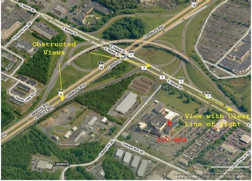
FIGURE 4 ZDC-WRS location relative to roads passing by. SUMMARY Aviation must consider PPD proliferation as inevitable. The key uncertainty in the presented results is the radiation pattern for emitter(s) installed in a vehicle. It is highly dependent on the structure of the vehicle and location of the RFI transmitter within the vehicle, which is not easily modeled. GNSS ground RF operating environment requirements may have to be improved by “hardening” from sighting and operational considerations. However, is 15–25 dB improvement even possible? We must evaluate implications for avionics. No interruptions of GPS reception by avionics have been reported to date. Should the Avionics Minimum Operational Performance Standards (MOPS) RFI mask address unintentional intentional emitters, while retaining the aggregate of –110.5 dBm/Hz within +/– 10 MHz? Should we add an A/J requirement to MOPS?

OCR for page 152
Global Navigation Satellite Systems 
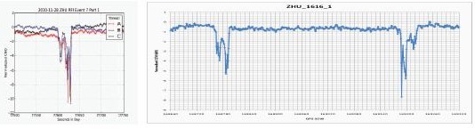
FIGURE 5 Degradation of normalized C/N0 versus GPS time-of-day (in seconds) at Houston WRS.