
GNSS Open Signals Interference Issues and Countermeasures
DU XIAODONG
Aerospace Long March Launch Vehicle Technology Co. Ltd
WANG FEIXUE and NIE JUNWEI
National University of Defense Technology
BACKGROUND
Global Navigation Satellite Systems (GNSS) can provide users with accurate PNT information services. It has already been used in various fields of national economy and peoples’ lives, such as communication, traffic, electric power, finance, security, dangerous goods management, and so on. These applications bring forward a critical demand on the continuity and accuracy of GNSS.
GNSS open signals have low power when arriving at the ground, low chip rate, and short period of PN codes, so they are easily interfered with by various electromagnetic signals. Therefore, we should pay attention to the interference issues of GNSS civil signals.
BeiDou-2 is planning to provide regional regional navigation satellite services in 2012 and will face the same issues. Figure 1 shows the BD-2 system space components.
CIVIL SIGNALS INTERFERENCE TYPES AND SOURCES
Interference Types
Civil signals will face two kinds of interference—intentional interference and unintentional interference. The intentional interference consists of jamming and spoofing. Figure 2 shows the types of interference.
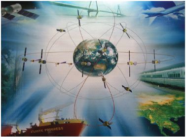
FIGURE 1 BD-2 system space components.
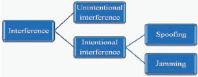
FIGURE 2 Interference types.
Interference Sources
Unintentional Interference Sources
Unintentional interference sources consist of three main components:
- Other systems in the same frequency band (including other navigation systems with spectrum overlap, transmitters occupying the navigation frequency band illegally).
- The harmonic, intermodulation, and dispersion components of the signals produced by radio broadcasting and communication emitters.
- The leakage of electromagnetic radiation in navigation frequency band produced by electronic equipment.
Harmonics may interfere with a variety of civilian GPS band signals as shown in Table 1.
Intentional Interference Sources
The intentional interference usually comes from man-made jammers. At present, civil band jammers can be divided into two types: (1) a suppressing jammer,
TABLE 1 Harmonics May Interface with GPS L1 Band
| ORDER | BAND (MHz) | USAGE |
| L1 | 1571.42-1579.42 | C7A-GPS |
| 2th | 785.71-788.71 | IMF TV |
| 3th | 523.807 - 526.473 | UHF TV |
| 4th | 392.855-394.855 | Mobile/Station |
| 5th | 314.284-315.884 | Mobile/Station |
| 6th | 261.903-263.237 | Mobile/Station |
| 7th | 224.488-225.631 | Broadcasting |
| 8th | 196.427-197.428 | VHF TV |
| 9th | 174.602- 175.491 | VHF TV |
| 10th | 157.142- 157.942 | VHF Maritime |
| 11th | 142.856-143.584 | VHF Military |
| 12th | 130.952- 131.618 | VHFCOM |
| 13th | 120.878- 121.494 | VHFOOM |
| 14th | 112.244-112.816 | VOR/ILS |
| 15th | 104.761 - 105.295 | FM |
| 16th | 98.214-98.714 | FM |
Source: Landry and Renard, 1997. Reprinted with permission.
which makes the receiver unable to output the PNT results, and (2) a spoofer, which induces the receiver to give false results.
Suppressing jammers’ detailed schemes are freely available from the Internet, and they are low-cost and simple designs. Therefore, the majority of jammers on the market are suppressing jammers. The detailed scheme of a 0.5 W GPS L1 suppressing jammer from the Internet is shown in Figure 3; the vehicle GPS jammer and GPS/ GLObal NAvigation Satellite System (GLONASS) jammer are shown in Figures 4 and 5. Figures 6 and 7 show the low-power and high-power GPS mobile integrated jammers.
Spoofers are more complex and expensive. Common products on the market are the frequency-sweep traction spoofers. The production of spoofers is not easy because of technical difficulties and high cost. Three kinds of spoofers are now being studied (Humphreys et al., 2008). Because the implementation costs are different, the effects of spoofers are not alike. A GPS signal generator is shown in Figure 8 that can be used as the source of interference, but the price is very high.
Because the intentional interference is deliberately caused by human factors, its location, transmission power, and boot time are more variable and difficult to examine.
CIVIL SIGNAL INTERFERENCE TYPICAL CASES
Recently, the news media has reported many civil GPS signal interference cases, and the construction of the BD system has encountered interference. The following will give some relevant cases.
It turns out that the second harmonic of the carrier of a U.S. National Time Service Center Channel 66 television transmitter falls right in the middle of the 1575.42 MHz GPS Band.1 Although Channel 66 has reduced the coverage, reduced the receiver power to 1,000 watts, and made the harmonic suppression to meet the requirements of the Federal Communications Commission, the GPS receiver is still unable to work within several miles of the transmitter.
In late 2009, engineers noticed that satellite-positioning receivers at Newark airport in New Jersey were suffering brief daily breaks in reception. Something was interfering with the signals from orbiting GPS satellites. It took two months for investigators from the Federal Aviation Administration to track down the problem: a driver who passed by on the nearby New Jersey Turnpike each day had a cheap GPS jammer in his truck.
In late 2009, researchers found that the B2 band of BD system Monitor Station reference receivers had been interfered with and was unable to obtain complete dual-frequency observations. After monitoring, the radio administration bureau found that a company warehouse nearby installed wireless video
____________
1 Comment on TV Channel 66, “Transmitters Jamming GPS Signals” [EB/OL], at http://blockyourid.com/~gbpprorg/mil/gps/gps_jammer2.txt.
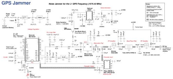
FIGURE 3 Detailed scheme of a 0.5 W GPS L1 suppressing jammer from the Internet, at http://servv89pn0aj.sn.sourcedns.com/~gbpprorg/mil/gps/gps_jammer.png.
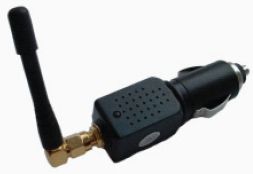
FIGURE 4 Vehicle GPS jammer.
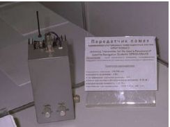
FIGURE 5 GPS/GLONASS jammer.

FIGURE 6 Low-power GPS mobile integrated jammer.

FIGURE 7 High-power GPS mobile integrated jammer.

FIGURE 8 Portable GPS signal generator.
surveillance equipment illegally, and the frequency of the emitter occupied the B2 working frequency band.
During 2009–2010, researchers found that the BD system Monitor Station reference receivers had been jammed occasionally in some areas and could not easily determine the interference sources. The receivers recovered after engineers started the built-in adaptive anti-jamming algorithm. Figure 9 displays the jammed power spectrum of B1 band.
As the GNSS has a wide range of applications, the interference would have serious implications. In the fields of traffic, power, communication, and finance, the interference will cause socio-economic disorder. It also poses a threat to armored cars, dangerous goods vehicles, and large equipment. Because of the impact of interference, the receiver cannot locate the position correctly or identify output error. Therefore, the civil aviation landing systems, which rely on GNSS, may lead to fatal catastrophic incidents.
CIVIL SIGNAL INTERFERENCE COUNTERMEASURES
Strengthen Navigation Frequency Spectrum Monitoring Within the Framework of Law
In China, the usage and protection of radio spectrum resources and the investigation, production, distribution, and importation of the radio equipment have clear legal provisions. Relevant laws and regulations are: Real Right Law of the People’s Republic of China, Criminal Law of the People’s Republic of China, Radio Regulations of the People’s Republic of China, and Radio Station License Regulations.
The protection of navigation signal spectrum resources relies on both the support of technology and the effective implementation of management measures.
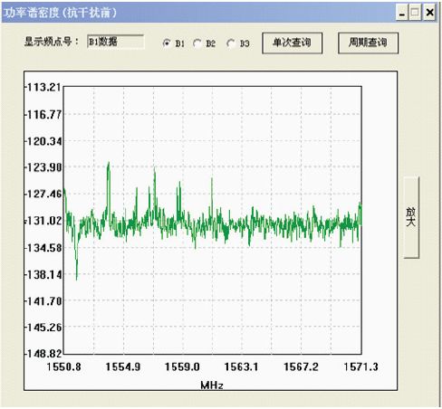
FIGURE 9 Jammed power spectrum of B1 band.
The China Bureau of Radio Regulation of the Chinese Ministry of Industry and Information has overall responsibility for administration and coordination of civil radio management. Its responsibilities are frequency spectrum monitoring, interference detection and investigation, matters of electromagnetic interference coordination, and transmission of radio waves in the air maintenance. Figures 10 and 11 show some radio monitoring equipment.
In the field of radio monitoring, the detection and location of high-power jammers has been a mature technology and has been widely used in engineering. At present, China possesses the ability of radio frequency spectrum detection and interference location investigation. But the low-power interference, which has serious impact on the navigation signals, can only be detected in limited range. The location and detection of a weak jammer takes a lot of manpower, material resources, and time. To enhance the navigation frequency monitoring and the detection of interference sources, the main issues include (1) high-sensitivity interference detection and (2) rapid location of the interference. However, the
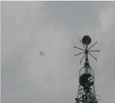
FIGURE 10 Fixed radio monitoring stations. Source: Beijing Radio Administration Bureau, at http://www.bjrab.gov.cn/jcjc/jcs/twzs/20101221/368.shtml.
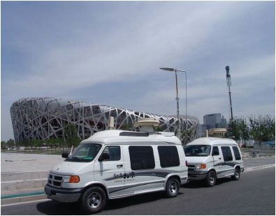
FIGURE 11 Radio monitoring vehicles. Source: Beijing Radio Administration Bureau, at http://www.bjrab.gov.cn/jcjc/jcs/twzs/20101221/364.shtml.
method of location and removal cannot meet users’ requirement of continuous services. Thus receivers with higher interference tolerance are demanded.
Enhance the Receivers’ Interference Tolerance
Fully Exploit Anti-jamming Performance of Modernized Navigation Signals
The modernized navigation signals enhance the civil signals’ interference tolerance. The anti-jamming potential of modern navigation signals is based on the following aspects.
1. Integrated application of multiple frequencies to avoid possible navigation unintentional interference. In the future, the civilian frequencies that can be used include BD-B1, B2, B3, GPS-L1, L2, L5, and GALILEO-E1, E5, E6, etc. Applying multiple navigation frequencies can effectively avoid the impact of unintentional interference, meaning that interference with one frequency signal does not affect the other frequency signals. This is equivalent to increased tolerance. The deficiency of this method is that it is only effective on unintentional interference.
2. Use of wider bandwidth signal to get greater gain of the spread spectrum. In the modernized GNSS open signals, there are signals with wider bandwidth, such as BD-B2 and GPS-L5. The higher chip rate increases the processing gain and anti-jam performance. So it can improve the ability of anti-jamming. Such a measure is both effective on intentional and unintentional interference.
3. Pilot signals improving tracking capability. Pilot signal is modulated by long-period PRN code without navigation message. Receivers can extend the coherent integration time as long as possible to improve signal-to-noise ratio and eliminate the impact of square loss, thus the sensitivity can be significantly improved. So it can enhance the robustness of the equipment to the interference condition. Such a measure is both effective in intentional and unintentional interference.
4. New message error correction coding scheme. Modernized GNSS signals adopt new-style forward error correction coding schemes. High-gain, soft-decision decoding can correct the navigation message error and improve the continuity of navigation in various kinds of interference. Such a measure is both available in intentional and unintentional interference.
Improving Anti-jamming Capability through Auxiliary Information
Currently, satellite navigation has been closely integrated with inertial navigation and mobile communication. In the future, integration with other systems will become a trend. Full use of auxiliary information of other systems or equipment will greatly improve the anti-jamming capability of satellite navigation receivers. At present, the method can be used in the following aspects:
- For static timing users, the receivers’ interference tolerance can be enhanced by setting precise coordinates and using high-stability clock.
- For vehicles, aircraft, and other dynamic users, GNSS/inertial navigation system integration can improve anti-jamming capability.
- With messages and other necessary information broadcast by 2G or 3G mobile communication networks, pilot positioning can be achieved directly and anti-jamming capability can be improved.
Active Anti-jamming Measures
Adding active anti-jamming measures to receivers can upgrade the ability of the anti-jam. At present, the methods that can be used in active anti-jamming include:
1. Time and frequency domain anti-jamming. Time and frequency domain processing can suppress various narrowband interference effectively. Anti-jamming capability can be improved by 40–70 dB based on the architecture of hardware and processing algorithms. The main advantages of the approach are that the instruments are low cost and easily integrated; however, its disadvantage is it is ineffective to wideband interference. Figure 12 presents the power spectrum comparison before and after anti-jam.
2. Spatial anti-jamming processing. Spatial processing is mainly using the antenna array disposal techniques from the direction of signal to distinguish the interference. Adaptive space-frequency and space-time filtering technology can effectively suppress various types of interference. According to the hardware scale and processing algorithms, we can get 30–60 dB or higher anti-jam improvement. Spatial processing can suppress multiple wideband and narrowband interference at the same time. But it has the disadvantages of complex hardware, large scale, and high cost, and the number of anti-wideband interference is directly related to the scale of hardware and software. Figure 13 presents the directional map of antenna array in spatial processing.
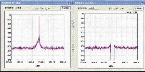
FIGURE 12 Power spectrum comparison before and after anti-jam.
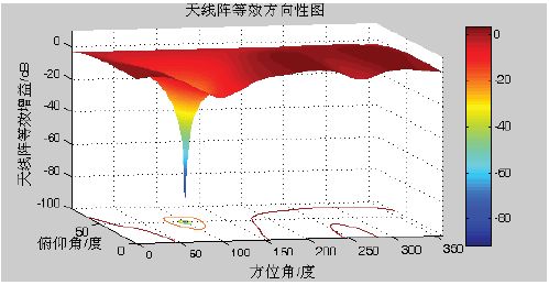
FIGURE 13 Directional map of antenna array in spatial processing.
In order to increase the active anti-jamming measures, we have to increase the complexity, size, power consumption, and implementation costs of the receivers. However, engineering has to considerer cost-effectiveness. For the individual user equipment, because of its constraints on size and power, we propose to use time-domain to suppress narrowband interference. For the critical civilian infrastructure equipment, we can appropriately increase the hardware scale and use the spatial-domain or polarization to enhance the anti-jamming capability and protect the safety of infrastructure.
Developing the Auto-integrity Technology in the Background of Interference
Using the RAIM (receiver autonomous integrity monitoring) technology, receivers can monitor abnormal navigation signals and mitigate errors of PNT calculation caused by false signals.
SUMMING UP
- Governments have a responsibility to protect the navigation frequency band against illegal interference.
- Technical measures can greatly improve the receiver’s anti-jamming capability. Good PNT services can be obtained by adopting proper anti-jamming techniques according to the role of GNSS in specific applications.
- Active anti-jamming technology will affect the accuracy of measure precision. Therefore, in the mapping and other precision application fields, active anti-jam technology is limited.
- Interference-free environments are the goal pursued by all satellite navigation users.
REFERENCES
Landry, R. Jr., and A. Renard. 1997. Analysis of Potential Interference Sources and Assessment of Present Solutions for GPS/GNSS Receivers[C]. 4th Saint-Petersburg on INS, May 26–28.
Humphreys, T.E., B.M. Ledvina, M.L. Psiaki, B.W. O’Hanlon, and P.M. Kintner Jr. 2008. Assessing the Spoofing Threat: Development of a Portable GPS Civilian Spoofer[C]. ION GNSS Conference Savanna, Georgia, September 16–19.
This page intentionally left blank.


