
Present and Future Applications of COMPASS Navigation Satellite System
ABSTRACT
After an overview of the COMPASS Navigation Satellite System, the author introduces its Radio Determination Satellite Service (RDSS) and Regional Navigation Satellite Service (RNSS) and their performances, which can serve group users based on location information sharing. The typical application modes of COMPASS group users are presented. Furthermore, possible applications in the near future are also explored.
OVERVIEW OF COMPASS’S THREE-STEP DEVELOPMENT STRATEGY
Research on satellite navigation in China was first initiated in the 1980s. Mainly learning from the GPS and GLObal NAvigation Satellite System (GLONASS), China had been groping for a development strategy for its own satellite navigation system. It is Academician Chen Yunfang who first proposed a positioning theory that makes use of two geostationary Earth orbit (GEO) satellites and user elevation. In 1994, the project based on this idea was formally approved by the state. A demonstration system of COMPASS was established after the successful launch of three GEOs between 2000 and 2003.
The COMPASS demonstration system consists of three GEOs, all of which are equipped with RDSS payloads (Figure 1). One of them is also equipped with RNSS experimental payloads. RDSS is the major service, with functions of positioning, user location report, short message communication, and timing.
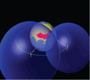
FIGURE 1 COMPASS Navigation Satellite System.
Phase II of COMPASS aims at meeting users’ demands in the Asia-Pacific region (Figure 2). A constellation made up of 12 satellites will be put in place before 2012. By then, the COMPASS system with RDSS and RNSS will be able to provide users with continuous positioning, velocity measurement, and location report services. COMPASS will achieve compatibility with GPS and provide equivalent accuracy as GPS.
Phase III of COMPASS is to establish a global constellation with 30 to 35 satellites by 2020 (Figure 3). It adopts RDSS and RNSS as well. As a member of the GNSS community, COMPASS will achieve compatibility and interoperability with GPS and Galileo within multi-frequency bands.
COMPASS SYSTEM’S PERFORMANCE
RDSS and RNSS
RDSS can provide information of both the user’s location and time parameters (X, Y, Z, T). It can provide location reports among the users, short message and timing services at the same time.
RNSS can provide user’s location, velocity, and time parameters (X, Y, Z, Vx, Vy, Vz, T).
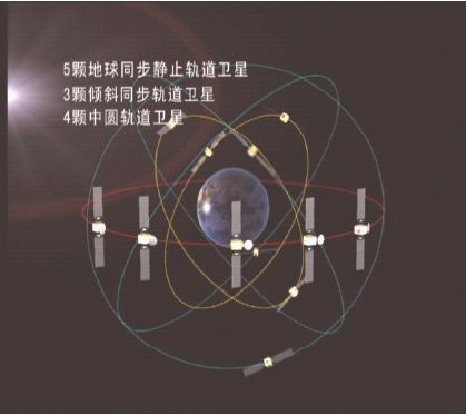
FIGURE 2 Phase II of COMPASS Navigation Satellite System.
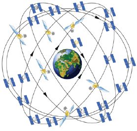
FIGURE 3 Phase III of COMPASS Navigation Satellite System.
Performance
Accuracy levels of the positioning and timing services provided by the COMPASS system can reach 10 m and 20~50 ns respectively, while the response time for its positioning and location reporting is 1 s. Two more features of the system are location information sharing among group users and feasibility of achieving possible interoperability with GPS as well as Galileo.
Major Group Users
The COMPASS system is mainly applied to group users based on location information services in the following sectors:
- Traffic Management, Transport of Hazardous Goods;
- Marine Fishery, Geology, Water Reserve;
- Fleet Management, Forest Fire Prevention, Relief in Earthquake and Flood; and
- Aerial and Offshore Rescue.
APPLICATION MODE
No matter what kind of application of COMPASS, there are three elements: (1) various sensors, (2) the COMPASS information system, (3) and the group user’s management center, which can be illustrated as in Figure 4.
A brief explanation of the three elements follows.
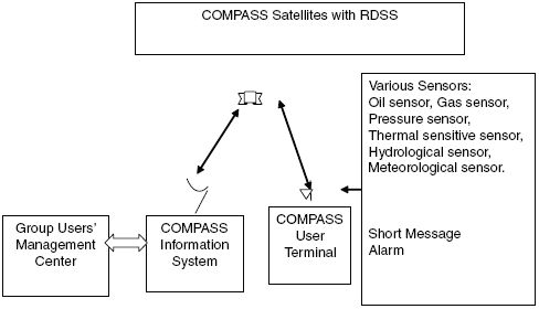
FIGURE 4 Typical application.
First, various sensors will gather information that will be used for further processing, such as the onboard sensors of networked vehicles, as well as onboard oil and gas sensors of networked ships, etc.
Second, the COMPASS information system, usually incorporating the user terminal, RDSS satellites, and COMPASS application center, can achieve marking of moving articles’ position and time, data transmission, and distribution.
Finally, the group user management center is in charge of cloud computing, intelligent processing, and real-time dispatching and management in various industries to satisfy the needs of all users within the group.
The above three elements constitute an integrated application mode of COMPASS Navigation Satellite System.
TYPICAL APPLICATION PROJECTS
COMPASS Dispatching System in Marine Fishery
China has realized offshore real-time monitoring of about 20,000 fishing vessels by taking advantage of COMPASS in rapid positioning, location report, and short message communication (Figure 5). Moreover, many other functions, such as alarms for dangerous zone and bad weather, monitoring and commanding, ship tracking, operation track recording, and oil fuel data collection, etc., are possible. An even larger-scale system for offshore group users is under construction.
COMPASS Hydrological Data Collection System at Three Gorges of the Yangtze River
Regular water reports about the Three Gorges Conservatory of the Yangtze River are urgently needed by local governments. The Hydrological Data Collection System (Figure 6) can get reports on the tributaries along the upstream of the Yangtze River covering an area of about 370,000 square kilometers; can provide automatic monitoring and reporting for cascade hydroelectric stations on the downstream of Jinsha River, with a coverage of 45.443 square kilometers; and can report on the hydroelectric stations on the middle stream of the Jinsha River. The system has successfully solved the problems of delays in flood forecasting for the upstream of the Yangtze River and scarce monitoring stations and inconvenient communication.
Moreover, a weather station has been set up at Mount Everest that helped in meteorological observations for the Beijing Olympic Games in 2008, as illustrated in Figure 7.
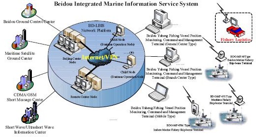
FIGURE 5 COMPASS dispatching system in marine fishery.
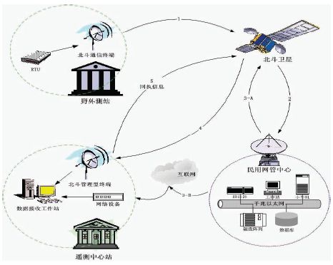
FIGURE 6 COMPASS hydrological data collection system.
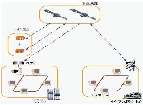
FIGURE 7 Meteorological observation system at Mount Everest.
Detection and Report of Forest Fire by COMPASS
A forest fire warning system based on COMPASS is supported by the National Forestry Bureau. This system can send real-time positions of all fire fighters, vehicles, and airplanes, make the related digital map, and keep everyone in contact by short messages. In this system, fire fighting airplanes can outline the areas on fire and inform the rescuers regarding tree species, terrain, and the onsite situation of the on-fire area, which is illustrated in Figure 8.
Inspection and Monitoring System for High-voltage Power Line in Remote Areas
The inspection and monitoring system for the 500-kilovolt power transmission line, which extends about 3,000 kilometers in total and has 4,000 inspection
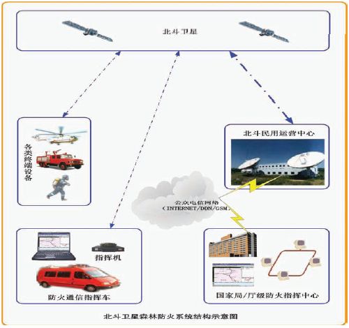
FIGURE 8 COMPASS forestry fire prevention system.
tower-poles in the Tsitsihar Super-grid Bureau of the State Grid Cooperation of China, can provide real-time inspection, dispatching, security, and recording of staff, vehicle, and helicopter. The inspection and monitoring system used by helicopter for high-voltage power lines is shown in Figure 9.
Yangtze River Environmental Protection and Energy Conservation in Shipping
COMPASS performs as a data center as well as distribution center in environmental protection and energy conservation of the Yangtze River shipping.
With the help of COMPASS, this vessel monitoring system provides real-time monitoring of the on-board and offshore dispatching systems. In this way, not only can voyage security be guaranteed but also exhaust emissions and energy
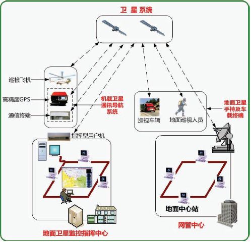
FIGURE 9 Inspection and monitoring system for high-voltage power line.
consumption can be reduced. The latter, however, is of more important significance to us.
COMPASS Vehicle Navigation System
The main objective of an automobile network is to share information of all vehicles in operation and to help lessen traffic jams. The key lies in the data transmission of cars on the road to the information center. COMPASS RDSS performs as a radio communication and positioning system, which is like the first runner in the automobile network relay race. The vehicle navigation system is illustrated in Figure 10.
The Two-Way Timing Service of COMPASS Can Provide a Standard of High Accuracy Time and Frequency for Upgrading the Old Power Grid
On February 18, 2011, an industrial park for COMPASS satellite navigation civil applications was set up at the Jiaozhou City of Shandong Province. Initial results of COMPASS timing services for the power industry have been satisfactory. Also in 2010, intelligent upgrading of 23,500-kilovolt stations of the East China Power Grid was completed successively. By taking advantage of high-accuracy timing services provided by COMPASS, both the accident rate caused by timing accuracy and the malfunction rate of sampled facilities are zero, exceeding the internationally accepted standards. How the time synchronization system of the intelligent power grid is incorporated is shown in Figure 11.
PROSPECTS OF INTEROPERABILITY BETWEEN COMPASS AND GPS
Coordination Between COMPASS and GPS Under the ITU Framework Has Been Accomplished
In September 2010, frequency coordination between COMPASS and GPS on the L band was finished, with the frequency compatibility of both authorized and open signals. Consensus has been achieved on the maximum and minimum power of B1C/L1C and B2a/L5 as well as the sequential correlation of spreading codes.
Interoperability
Interoperability in B1C/L1C and B2a/L5 will be discussed for the users’ benefits to the largest extent.
Enormous efforts will be made to reduce complexity of receivers and provide the most convenient access.
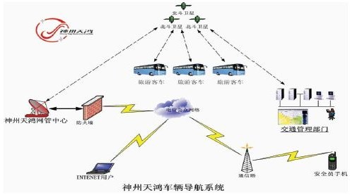
FIGURE 10 Vehicle navigation system.
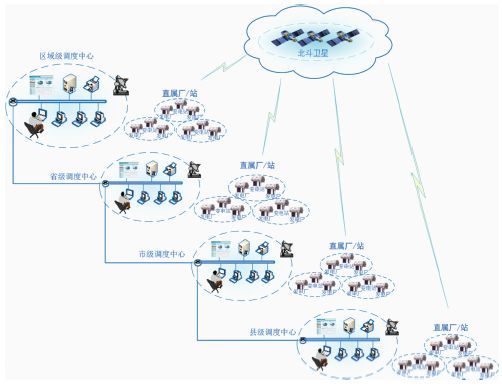
FIGURE 11 COMPASS two-way timing service system.
CONCLUSION
- COMPASS has been largely used as the three-step development strategy planned.
- The position data sharing service by COMPASS has been widely accepted.
- There is a good and broad foundation for cooperation in compatibility and interoperability for GPS and COMPASS.
- Some Perspectives on Future Cooperation
There are many possible areas of cooperation between COMPASS and GPS, such as aerial navigation application and standards discussion, geodetic surveying and the coordinate system, receiver technology and consumer products, as well as mitigating the interference with civil signals, etc.


