
Application of GNSS to Environmental Studies
PENINA AXELRAD
Colorado Center for Astrodynamics Research
University of Colorado at Boulder
ABSTRACT
GNSS signals are influenced by the transmission media and interaction with surfaces near the receiving antenna. Observations of the modified signals from the ground and from airborne and spaceborne platforms allow for scientific study of the ionosphere, atmosphere, and Earth surface. Methods using standard ground-based receivers provide estimates of atmospheric water vapor and soil moisture. Specialized receivers measuring occulted signals enable high-resolution estimates of atmospheric density and temperature. Receivers measuring reflected signals are used to infer surface roughness and reflectivity, which can be related to surface conditions like ocean winds, soil moisture, and ice type. Modern receivers that can use multiple GNSS constellations will provide a rich global data set for environmental study.
INTRODUCTION
Intended primarily for position, navigation, and timing (PNT), Global Navigation Satellite Systems (GNSS) bathe Earth with a multitude of highly stable ranging signals that are readily available for use in probing the atmosphere and surface of Earth. Furthermore, GNSS receivers deployed in diverse environments (land, marine, air, space) for conventional PNT purposes can also be utilized to make environmental observations with these same signals. All GNSS signals received on the ground or in low Earth orbit traverse the ionosphere. At L-band, frequency dependent dispersion of modulation and carrier phase allows total
electron content to be observed by measuring range and/or phase at two or more frequencies, or through the dispersion of code and carrier. Atmospheric attenuation and delay observed by ground stations can be modeled/observed by estimating parameters associated with empirical models. Measuring the phase delay and amplitude variations of occulting signals from aircraft or satellites enables high-resolution retrieval of atmospheric density, which also exposes temperature and water vapor content. Signals reflected by Earth contain information on surface properties including roughness and reflectivity. Measuring reflected signals from ground, aircraft, or spacecraft enables retrieval of surface conditions including soil moisture, sea ice type, and ocean surface winds.
ATMOSPHERIC SENSING
Ground-based receivers at known locations measuring pseudorange and phase to all GNSS satellites in view provide useful observations for estimating precipitable water vapor (PWV) in the atmosphere. The integrated atmospheric effect along the satellite to receiver ray path can be isolated by removing all other sources of error. The technique was established in the early 1990s (Bevis et al., 1992; Rocken et al., 1993) and is done fairly routinely today (Rocken et al., 2005), although the estimates are not sufficiently widespread to be operationally incorporated in the weather prediction models. Ground-based GNSS PWV sensing relies on a network of geodetic-quality dual-frequency receivers at known locations, precise orbit models, and accurate models relating temperature and moisture content in the atmosphere. High-precision software like Bernese (Dach et al., 2007) must be used to ensure that all other error sources have been eliminated.
A more powerful worldwide approach to exploit GNSS for atmospheric sensing relies on radio occultations measured by orbiting satellites. Researchers have studied the atmospheres of Mars, Venus, and Jupiter since the 1970s through radio occultation. The use of GPS for radio occultation (GPS-RO) measurements from LEO was first initiated in 1995 by the GPS/MET experiment (Schreiner et al., 1998; Yunck et al., 2000). This satellite, placed in a 735 km orbit at 70 degree inclination, flew a modified TurboRogue receiver designed to track signals from above for precise orbit determination and from a separate antenna, signals passing close to the limb of Earth. Now, in 2011, there are about a dozen satellites flying operational or experimental occultation payloads including the six-satellite COSMIC constellation (Anthes et al., 2008), CHAMP, SAC-C, GRAS/Metop, C/NOFS, GRACE-A, and TerrSAR-X. These platforms use forward and backward facing antennas to measure GNSS signals as they rise or set and are occulted by Earth’s atmosphere as shown in Figure 1. A vertical profile of the bending angle through the ionosphere, stratosphere, and troposphere is determined from the excess phase measurements. Refractivity is derived from the bending angles and then further analyzed to determine electron density profiles, temperature, pressure, and water vapor. At its peak performance, COSMIC provided approximately
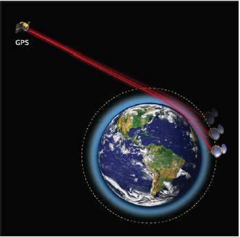
FIGURE 1 Illustration of GPS radio occultation. Sources: The Earth image is provided by the SeaWiFS Project, NASA Goddard Space Flight Center, and ORBIMAGE. The Leo satellite is “Courtesy of Orbital Corporation.” The image composition is © University Corporation for Atmospheric Research. Courtesy University Corporation for Atmospheric Research.
2,500 soundings per day. These observations are already being used as key inputs to numerical weather prediction (Cucurull et al., 2007), atmospheric studies, and climate monitoring, and their impact and significance are expected to grow in the future (Anthes et al., 2008). Compelling results have also been presented (Huang et al., 2010) illustrating the positive benefit of GPS occultation observations on severe weather prediction. New applications being developed include measurement of the planetary boundary layer, temperature inversions, and turbulence. It is notable that a National Research Council decadal survey in 2007 recommended that GPS-RO be made operational by NOAA and that additional GPS-RO instruments be put on NASA science platforms whenever appropriate (NRC, 2007).
Increasing the number of GNSS transmitters and the constellation properties with Compass and Galileo will directly increase coverage of Earth’s atmosphere and the timeliness of the observations. This will have a tremendous impact on understanding of Earth in the long term (climate change) and short term (numerical weather prediction, severe storm monitoring). Adding new LEO observing satellites able to track multiple GNSS systems will contribute thousands of observations daily.
SURFACE SENSING
When GNSS is used for conventional PNT purposes, reflections from surfaces near the receiving antenna, termed multipath, introduce errors in the solution by distorting the composite signal tracked by the receiver. By deliberately monitoring and modeling the effects of the reflections, surface and near-surface properties can be inferred. Two basic approaches are being used. The first, pioneered by Kristine Larson (Larson et al., 2008a, 2008b, 2010; Small et al., 2010) uses standard geodetic ground-based receiving equipment and models the effect of the surface reflections on the composite signal tracked by the receiver. The second approach, initially investigated by Martin-Neira (1993) and separately by Katzberg and Garrison (1996) uses an airborne or spaceborne receiver with both a standard upward-facing and specialized downward-facing antenna to separately track direct and reflected signals.
Figure 2 shows the oscillations in the signal-to-noise ratio that are typical of GPS tracking in the presence of ground reflections at GPS tracking sites like the Plate Boundary Observatory (PBO) site in Marshall, Colorado (Figure 3). By relating the frequency and phase shift of these oscillations to the reflectivity and location of the reflection point on the ground, researchers have been able to
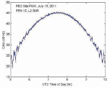
FIGURE 2 Time history of C/No from Marshall, Colorado, PBO site. Oscillations near the start and end of the pass are due to multipath from the ground. Note: This plot is based on data provided by the Plate Boundary Observatory operated by UNAVCO for EarthScope (http://www.earthscope.org) and supported by the National Science Foundation (No. EAR-0350028 and EAR-0732947).
observe changes in soil moisture content (Figure 4) (Larson et al., 2008a, 2008b, 2010), crop growth (Small et al., 2010), and snow depth (Larson et al., 2009). Because this approach relies on standard geodetic receivers, the proliferation of such receivers for other geodetic purposes including earthquake monitoring, will make it possible to coincidentally observe Earth surface conditions with no additional expense or installations.
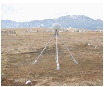
FIGURE 3 GPS Antenna at Marshall, CO PBO site used for soil moisture and snow experiments. Source: Larson et al., 2008a. Courtesy UNAVCO.

FIGURE 4 Daily precipitation (blue), water content reflectometer range (gray), and GPS soil moisture measurements (colors) for PBO GPS site at Marshall, Colorado. Source: Larson et al., 2008b, Figure 3. Courtesy of Kristine Larson,
Figure 5 shows an airborne configuration for surface sensing using GNSS reflections, and Figure 6 (Esterhuizen, 2006) illustrates the receiver elements for tracking direct and reflected signals for this scenario. For this delay-mapping approach, a zenith antenna receives direct GPS signals, and a nadir antenna (with opposite polarization) receives the same GPS signals after reflection from surface below. Figure 7 compares the signal correlation function for a direct and reflected signal. The delay, attenuation, and spreading of the reflected signals provide the observability of surface properties. Various researchers have demonstrated the ability to detect ocean surface winds (Garrison et al., 2002), soil moisture (Katzberg et al., 2005; Masters et al., 2004), ice and frozen surface roughness (Rivas et al., 2010), and land cover from these observations. While initial results look promising, this technique has not yet been as firmly established as occultation measurements of the atmosphere.
Measurements from space of GPS signals reflected from Earth’s surface are also of interest. The concept was first demonstrated from space using data from the Shuttle SIR-C radar (Lowe et al., 2002). Gleason (2006) showed observations of ocean, ice, and land from GPS reflection data collected onboard the UK-DMC.
CONCLUSIONS
Innovative uses for GNSS signals for probing Earth’s atmosphere, ionosphere, and surface will certainly continue to develop as more signals and more advanced signals become available. This will enable an ever-increasing improvement in our ability to measure and predict changes in Earth’s environment.
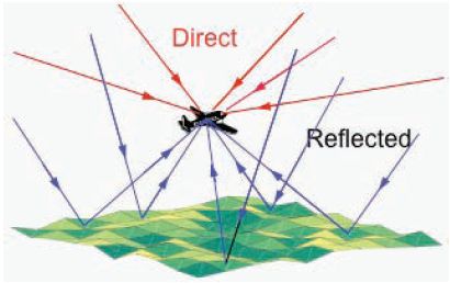
FIGURE 5 Airborne surface sensing based on reflected GNSS signals.
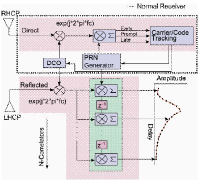
FIGURE 6 Delay mapping receiver used for characterization of surface height, roughness, and reflectivity. Source: Esterhuizen, 2006, Figure 2.5. Courtesy of Stephan Esterhuizen.
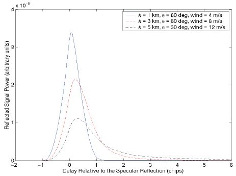
FIGURE 7 Model of effect of surface conditions on correlation function for reflected signals.
REFERENCES
Anthes, R.A., P.A. Bernhardt, Y. Chen, L. Cucurull, K.F. Dymond, D. Ector, S.B. Healy, S.-P. Ho, D.C. Hunt, Y.-H. Kuo, H. Liu, K. Manning, C. McCormick, T.K. Meehan, W.J. Randel, C. Rocken, W.S. Schreiner, S.V. Sokolovskiy, S. Syndergaard, D.C. Thompson, K.E. Trenberth, T.-K. Wee, N.L. Yen, and Z. Zeng. 2008. The COSMIC/FORMOSAT-3 mission: early results. Bulletin of the American Meteorological Society 89(3): 313–333.
Bevis, M., S. Businger, T.A. Herring, C. Rocken, R.A. Anthes, and R.H. Ware. 1992. GPS meteorology: remote sensing of atmospheric water vapor using the Global Positioning System. Journal of Geophysical Research 97(D14): 15787–15801.
Cucurull, L., J.C. Derber, R. Treadon, and R.J. Purser. 2007. Assimilation of Global Positioning System radio occultation observations into NCEP’s Global Data Assimilation System. Monthly Weather Review 135(9): 3174–3193.
Dach, R., U. Hugentobler, P. Fridez, and M. Meindl. 2007. Bernese GPS Software Version 5.0 Documentation. Astronomical Institute, University of Bern, Switzerland.
Esterhuizen, S. 2006. The Design, Construction, and Testing of a Modular GPS Bistatic Radar Software Receiver for Small Platforms. M.S. Thesis, University of Colorado, Boulder.
Garrison, J.L., A. Komjathy, V.U. Zavorotny, and S.J. Katzberg. 2002. Wind speed measurement using forward scattered GPS signals. IEEE Transactions on Geoscience and Remote Sensing 40(1): 50–65.
Gleason, S. 2006. Remote Sensing of Ocean, Ice and Land Surfaces Using Bistatically Scattered GNSS Signals From Low Earth Orbit. 2006. PhD Dissertation. University of Surrey, Guildford, Surrey, United Kingdom.
Huang, C.Y., Y.-H. Kuo, S.-Y. Chen, C.-T. Terng, F.-C. Chien, P.-L. Lin, M.-T. Kueh, S.-H. Chen, M.-J. Yang, C.-J. Wang, A.P. Rao. 2010. Impact of GPS radio occultation data assimilation on regional weather predictions. GPS Solutions 14(1): 35–49.
Katzberg, S.J., and J. Garrison. 1996. Utilizing GPS to Determine Ionospheric Delay Over the Ocean. NASA Technical Memorandum 4750. Washington, D.C.: NASA.
Katzberg, S.J., O. Torres, M.S. Grant, and D. Masers. 2005. Utilizing calibrated GPS reflected signals to estimate soil reflectivity and dielectric constant: results from SMEX02, Remote Sensing of Environment 100(1): 17–28.
Larson, K.M., E.E. Small, E. Gutmann, A. Bilich, P. Axelrad, and J. Braun. 2008a. Using GPS multipath to measure soil moisture fluctuations: initial results. GPS Solutions 12(3): 173–177.
Larson, K.M., E.E. Small, E.D. Gutmann, A.L. Bilich, J.J. Braun, and V.U. Zavorotny. 2008b. Use of GPS receivers as a soil moisture network for water cycle studies. Geophysical Research Letters 35(24): 1–5.
Larson, K.M., E.D. Gutmann, V.U. Zavorotny, J.J. Braun, M.W. Williams, and F.G. Nievinski, 2009. Can we measure snow depth with GPS receivers? Geophysical Research Letters 36(17): 1–5.
Larson, K.M., J.J. Braun, E.E. Small, V.U. Zavorotny, E.D. Gutmann, and A.L. Bilich. 2010. GPS multipath and its relation to near-surface soil moisture content. IEEE Journal of Selected Topics in Applied Earth Observations and Remote Sensing 3(1): 91–99.
Lowe, S.T., J.L. LaBrecque, C. Zuffada, L.J. Romans, L.E. Young, and G.A. Hajj. 2002. First space-borne observation of an Earth-reflected GPS signal. Radio Science 37(1): 1-28.
Martin-Neira, M. 1993. A passive reflectometry and interferometry system (PARIS): application to ocean altimetry. ESA Journal 17: 331–355.
Masters, D., P. Axelrad, and S. Katzberg. 2004. Initial results of land-reflected GPS bistatic radar measurements in SMEX02, Remote Sensing of Environment 92(4): 507–520.
NRC (National Research Council). 2007. Earth Science and Applications from Space: National Imperatives for the Next Decade and Beyond. Washington, D.C.: National Academies Press.
Rivas, M.B., J. Maslanik, and P. Axelrad. 2010. Bistatic scattering of GPS signals off Arctic Sea ice. IEEE Transactions on Geoscience and Remote Sensing 48(3): 1548–1553.
Rocken, C., R. Ware, T. Van Hove, F. Solheim, C. Alber, J. Johnson, M. Bevis, and S. Businger. 1993. Sensing atmospheric water vapor with the Global Positioning System. Geophysical Research Letters 20(23): 2631–2634.
Rocken, C., J. Johnson, T. Van Hove, T. Iwabuchi. 2005. Atmospheric water vapor and geoid measurements in the open ocean with GPS. Geophysical Research Letters 32(12): 1–3.
Schreiner, W., D. Hunt, C., Rocken, and S. Sokolovskiy. 1998. Precise GPS Data Processing for the GPS/MET Radio Occultation Mission at UCAR. Pp. 103–112 in Proceedings of the 1998 National Technical Meeting of The Institute of Navigation, Long Beach, Calif., January 1998.
Small, E.E., K.M. Larson, and J. J. Braun. 2010. Sensing vegetation growth using reflected GPS signals. Geophysical Research Letters 37(L12401): 1–5.
Yunck, T.P., C.H. Liu, and R. Ware. 2000. A history of GPS sounding. Terrestrial, Atmospheric and Oceanic Science 11(1): 1–20.
This page intentionally left blank.


