
A Global Safety of Life Service from Multiple GNSS Constellations
PER ENGE
Stanford University
ABSTRACT
The Global Positioning System serves 1 billion civil users with applications including: navigation for cars, aircraft, ships, spacecraft, pedestrians, and emergency services; time transfer for telecommunications, finance, and power delivery; and a breadth of scientific uses. Cognizant of this utility, the Russians are rejuvenating their satellite navigation system, and new systems are being fielded by China, Europe, India, and Japan. Taken together, this Global Navigation Satellite System will provide geometric diversity with more than 100 navigation satellites, all with triple frequency diversity for civil use. This paper will briefly describe the technology with a focus on safety of life applications.
INTRODUCTION
Satellite navigation serves a wide breadth of applications based on the satellites depicted in Figure 1. As shown, the vast majority of these satellites are in medium Earth orbit (MEO), with some assistance from satellites in geostationary orbits (GEO). In 2011, most of these satellites belong to the Global Positioning System (GPS) originally developed by the U.S. Department of Defense. This development began in the 1970s when the planners predicted that GPS would serve a total of 40,000 military users with some ancillary civil use. Today, the civil community ships more than 10 million GPS receivers per month. The GPS tail now wags the dog, and the civil community has generated an unexpected breadth of applications.
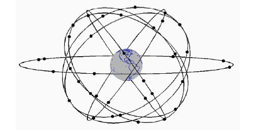
FIGURE 1 Today, GPS has approximately 31 satellites in medium Earth orbit. GPS is augmented by seven satellites in geostationary orbit. Source: Adapted from van Diggelen, 2009. Reprinted courtesy Frank van Diggelen.
For example, every new Boeing or Airbus aircraft carries a GPS receiver for navigation in the enroute and terminal area airspace. GPS is also used to guide aircraft while approaching airports. In some cases, it provides the critical vertical dimension of location down to altitudes of 200 feet.
In addition, most new smart phones or feature phones carry GPS receivers that have a bill of materials around $1. These receivers are used to guide our walking and driving lives. They also provide our location automatically to emergency services when we make such a call. In time, they will provide our location to good Samaritans standing next to automatic electronic defibrillators when someone suffers a heart attack. GPS receivers in cell phones will also serve significantly less uplifting applications that push advertising to our phones based on our location.
Other applications include ship navigation, pointing information for spacecraft, land survey, energy exploration; and time transfer for telecommunications, power delivery, and financial transactions.
Attracted by this utility, Russia is rejuvenating its satellite navigation system, called GLONASS. China is expanding their regional system, BeiDou (also known as Compass), to include global coverage. Europe has launched its first prototype satellites for the Galileo system. Japan and India have launched satellites for the regional systems. Figure 2 depicts a satellite navigation future based on more than 100 satellites from this family of systems. Taken together, we will have a Global Navigation Satellite System (GNSS).
The next section describes the new signals to be delivered by this multiplicity of constellations. It will be followed by a focus on my area of greatest interest:
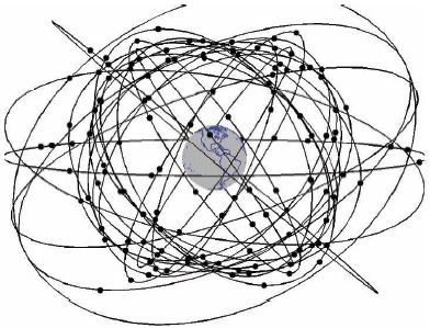
FIGURE 2 In the future, GNSS may grow to include more than 100 satellites, mostly in medium Earth orbit, with some in geostationary and inclined elliptical orbits. Source: Adapted from van Diggelen, 2009. Reprinted courtesy Frank van Diggelen.
safety of life applications and civil aviation. The following section discusses our continuing concern with radio frequency interference (RFI), and the final section provides a brief summary of the paper.
FREQUENCY DIVERSITY FOR SATELLITE NAVIGATION
The multiplicity of satellites described above will provide geometric diversity. Happily, the new satellites will also provide frequency diversity for civil users. Each new satellite will radiate civil signals at three frequencies rather than the single civil frequency offered today.
The top trace in Figure 3 shows the spectrum for the GPS satellites that are currently being launched. These new satellites broadcast at three civil frequencies: L1, L2, and L5. L1 is 1575.42 MHz and home for the so-called clear access (C/A) signal. This signal is a spread spectrum with a modest chipping rate of 1 Mcps. Even so, it is the basis for all of the civil applications described above. L1 C/A overlays military signals in this same band. L2 is 1227.60 MHz and also carries a civil signal with a 1 Mcps chipping rate on the seven most recent GPS satellites. Taken together, L1 and L2 provide redundancy to combat accidental RFI and a means to remove the dispersive delay due to the ionosphere. Both features are important. RFI is becoming more prevalent in the GPS bands, and the ionosphere is the largest natural error source.
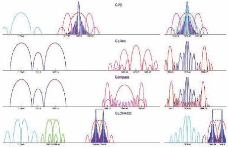
FIGURE 3 Signal spectra for GPS, Galileo, Compass, and GLONASS. From the left, new GPS satellites radiate at L5 (1176.45 MHz), L2 (1227.60 MHz), and L1 (1575.42 MHz). Source: Liang Heng, Stanford University. Reprinted with permission.
At 1176.45 MHz, L5 is the home for the first civil signal with a 10 Mcps chipping rate. It provides 10 dB more processing gain against RFI and can be used with L1 to remove the ionospheric delay. L1 and L5 are particularly important to aviation and other safety of life applications. They both fall in Aeronautical Radio Navigation System (ARNS) portions of the radio spectrum. Unlike L2, these ARNS signals may be used by civil aircraft to provide navigation in poor visibility as part of instrument flight rules (IFRs). Taken as a triplet, L1/L2/L5 allow receivers to form beat frequency signals that can be used to resolve the carrier phase ambiguity and enable phase interferometric measurements for very high precision.
The signals for GLONASS, Galileo, and Compass are also shown in Figure 3. As shown, they are not identical to the GPS signal shown in the top trace. However, they share the main features: triple frequency diversity with at least two signals in ARNS bands surrounding L1 and L5.
IMPACT ON CIVIL AVIATION AND SAFETY OF LIFE APPLICATIONS
Civil aviation has augmented GPS to detect faults or rare normal conditions that threaten flight safety. Indeed, most safety-of-life applications require mechanisms to mitigate the feared events that may present hazardously misleading information to the navigator. Faults are failures in the man-made portions of our navigation systems. The probability of a fault in the GPS system is approximately 10–5 per hour per satellite. The target level of safety for an aircraft navigation system is approximately 10–7 per hour or 100 times smaller than the observed failure rate. Similarly, rare normal conditions, notably the ionosphere, can introduce location errors that may be potentially hazardous to aircraft safety. These can occur several times per year during the peak of the solar cycle. In these peak years, the rate of these events is more than 100 times greater than the target level of safety for aviation. Hence, the civil aviation community has augmented GPS with systems that detect and remove errors due to these faults and rare normal conditions. Three such augmentation strategies exist.
(1) Ground-based augmentation systems (GBAS) are located at the airport to be served. Reference receivers monitor the GPS (or GNSS) signals. Because the reference receivers are at known locations, they can generate corrections to remove the nominal GPS errors, and they can generate alarms to flag satellites that cannot be reasonably corrected and characterized. All the reference receivers are on the airport property. Thus, the corrections and alarms are only valid within 100 kilometers or so around the airport. We call this the terminal airspace. Given this limitation on range of applicability, GBAS uses a VHF data broadcast to communicate with nearby aircraft.
(2) Space-based augmentation systems (SBAS) spread their reference receivers across continental areas. For example, some 38 stations are used to cover North America. These receivers send their GPS measurement data to master stations that generate corrections and error bounding data that is valid over the area spanned by the reference network. Because the data is valid over continental areas, SBAS uses a geostationary satellite to broadcast this navigation safety data to the airborne fleet.
(3) In contrast to SBAS and GBAS, aircraft-based augmentation systems (ABAS) are self contained. In fact, ABAS include a family of fault detection techniques known as receiver autonomous integrity monitoring (RAIM). SBAS and GBAS detect faults by comparing the GPS measurements to ground truth. RAIM compares the GPS measurement from one satellite to the consensus of the other satellites in view. Mathematically, RAIM is based on the residuals of the individual GPS measurements relative to the least squares navigation solution based on all satellites in view. RAIM is attractive because it does not need a ground reference network or a real-time broadcast from the ground network to the aircraft. However, the RAIM fault detection capability is weak compared to SBAS or GBAS because it does not have access to ground truth. The navigation solution must be over-specified and the geometries of the underlying subset solutions must be strong. Thus, RAIM has not yet been used for vertical guidance. It has only been approved for lateral guidance.
With the advent of the new constellations described above, RAIM may be able to support vertical navigation. After all, geometric diversity means that the navigation solutions will be over-specified and that the subset geometries will be stronger. The air navigation community is researching this possibility and has developed a concept imaginatively known as advanced RAIM or ARAIM.
Like its predecessor, ARAIM is based on the high availability of over-specified navigation solutions. However, it is subject to a more stringent safety proof than RAIM, because ARAIM targets vertical guidance and must overbound the vertical errors at the 10 m level. In contrast, RAIM for lateral guidance only needed to protect against lateral errors of 200 m or more. For these reasons, ARAIM has been subject to greater scrutiny than RAIM, and this examination has found an issue of concern: the safety community is concerned that ARAIM would not detect any faults that caused the entire GNSS constellation to rotate relative to the Earth. These would not be detected by a residuals test but could be hazardous. After all, the aircraft would have an error relative to the Earth’s surface. Hence, current research focuses on architectures that would combine ARAIM and SBAS or GBAS.
If a combination of ARAIM and SBAS can be proven to be safe, then it may be able to support navigation down to altitudes of only 100 feet over the airport
surface. Because ARAIM + SBAS would be a multi-constellation capability, it would be independent of the health of any one of the core GNSS constellations. Aviation and safety-of-life applications would welcome this robustness.
RADIO FREQUENCY INTERFERENCE
As mentioned earlier, GPS satellites broadcast from MEO, and so the satellites are approximately 12,000 miles above the receivers. These satellites are placed at this altitude so that an individual satellite covers one-third of Earth’s surface. With 30 satellites carefully arranged in MEO, all earthbound users of GPS (with a clear view of the sky) can see at least the prerequisite four satellites to instantaneously determine three dimensions of location plus time. MEO is used so that a reasonably sized constellation can enable navigation worldwide.
However, MEO signals are weak when they reach Earth, and GNSS signals have a received power of only 10–16 Watts. They can be easily overwhelmed by Earth-sourced interfering transmissions at the GPS frequency. This RFI can be scheduled, accidental, or malevolent. Amongst these, deliberate interference, called jamming, is the looming threat to safety-of-life applications.
In the past year, so-called personal privacy devices (PPDs) have become widely available on the Internet, and such a jammer is shown in Figure 4. The
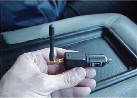
FIGURE 4 Example of a personal privacy device (PPD).
most inexpensive PPDs are single antenna devices that jam the one GPS signal frequency (L1) that is used by most users. More expensive units have multiple antennas and attack all three GPS signal frequencies (L1, L2, and L5). As such, these attackers anticipate the next generation of GPS user equipment that would continue to function if only one or two of the three frequencies were jammed. Other PPDs jam GPS and the cell phone frequencies at the same time, shutting down all calls. They are preferred by car thieves that wish to prevent on-car warning systems from reporting the GPS location of a stolen car to the authorities.
PPDs range in price from $30 to more than $300 based on the number of frequencies under attack and the transmitted power. They radiate powers from a few milli-watts to hundreds of milli-watts. The former knock out GPS receivers for hundreds of yards, and the latter can have dangerous effects for many miles.
As their name suggests, PPDs are marketed to individuals that fear for their privacy. This sales strategy seems to be effective. An investigation recently initiated by the Federal Aviation Administration (FAA) revealed that trucks traveling on the New Jersey Turnpike carry these devices. Perhaps, the drivers worry that the company dispatcher is monitoring their locations. Ironically, the attention of the dispatcher must be drawn to the truck that never provides location reports.
In any event, a PPD can cause collateral damage much greater than any privacy protection the user may possible enjoy. The above-mentioned FAA investigation was sparked while a GBAS at Newark International Airport was being installed. As described above, GBAS uses GPS receivers at the airport to aid GPS receivers in the approaching aircraft. The GBAS antennas were placed next to the New Jersey Turnpike, and the ground receivers suffered frequent continuity breaks during the test period. These breaks were due to PPDs carried by vehicles on the New Jersey Turnpike. The United States is currently investigating legal and technical remedies for PPDs. At Newark, the antennas will be relocated, and the system will be reconfigured to better tolerate short outages on a subset of the antennas.
For the longer term, the FAA focuses on alternate position navigation and time (APNT) based on terrestrial radio navigation and inertial navigation. Today, the aviation community continues to operate the full set of terrestrial navigation aids that predated GPS. These include VHF omni-directional range (VOR), distance measuring equipment (DME), and instrument landing systems (ILS). If GPS is jammed or suffers from some other systemic failure, pilots can revert to these systems. However, this terrestrial network is expensive and does not support the navigation capabilities needed for the Next Generation Air Traffic Management System (NextGen). It needs to be reconfigured to reduce cost and provide area navigation rather than point-to-point navigation. NextGen is predicated on area navigation, which is not fully backed up by today’s ground-based network.
To this end, the APNT effort focuses on the provision of area navigation for all enroute and terminal airspace over CONUS and approach navigation for all airports required for safety and commerce. APNT should be independent of GNSS. Rather it should be based on navigation aids that can be cost effectively
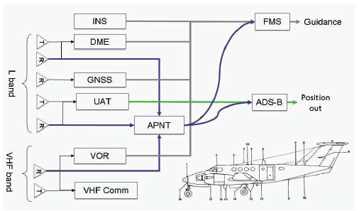
FIGURE 5 Potential sources of alternate position, navigation and time, including inertial navigation systems, distance measuring equipment, universal access transponder, VHF omni-directional radio, and VHF communications.
retained or are planned for installation in the next decade. This investigation has included all of the navigation aids shown in Figure 5 and has focused on DME and ground-based transmitters planned for the next generation of surveillance.
SUMMARY
GPS serves well with approximately 1 billion users utilizing a surprising breadth of applications. In the future, the capability of satellite navigation will multiply as GPS is joined by a rejuvenated system from Russia and new systems from China, Europe, India, and Japan. This multiplicity of ranging sources will provide geometric diversity. Moreover, each of these satellites will radiate ranging signals for civilians at three or more frequencies, and some of these new signals will have 10 times the bandwidth of the GPS C/A code signal that enables the vast majority of present applications. Thus, we can expect a new wave of applications that leverage these new technical capabilities.
However, radio frequency interference will be a continuing challenge to those applications that involve safety of life. Concern for privacy is great, so jammers designed to protect privacy will wreak collateral havoc. Moreover, the pressure to find new radio spectrum for worldwide Internet access will endanger the weak GNSS signals coming from medium Earth orbit.
REFERENCE
van Diggelen, F. 2009. A-GPS: Assisted GPS, GNSS, and SBAS. Norwood, Mass.: Artech House.


