
The Water Cycle: An Agent of Change
Water has helped shape our planet to produce the world in which we now live. Knowing how water has acted throughout Earth’s history and how water cycles function on other planets will broaden our understanding of how Earth’s water cycle functions. This knowledge will allow us to better predict how human and natural factors will combine to produce the world we leave to our children and our children’s children.
Water plays multiple roles in the evolving physical system of the planet. It shapes the landscape as rivers and glaciers flow over the surface, waves break on shorelines, and freeze-thaw cycles crumble rocks. Water influences the movement of energy through the climate system as a greenhouse gas absorbing radiation and reemitting it to the surface; a reflector of sunlight when condensed into clouds, snow, and ice; and a transporter of heat when evaporating, circulating, and condensing; it influences the distribution of Earth’s gravity field. The distribution of water affects the location and character of life, the movement of Earth’s crust, and even the rotation rate of the planet. The flow, phase changes, accumulation, and dispersal of water around the world—the water cycle—vary substantially with time and location. Thus, water does not respond passively to physical processes governing Earth: it is a dynamic agent whose influence is central to processes that produced today’s world and that will affect its evolution into the future.
Human intervention in the water cycle alters water’s dynamic role on the planet. Humans have become major agents alongside nature in the functioning of the water cycle, through water management and changes in the land, atmosphere, and ocean that alter natural water processes. Humans also are altering Earth’s climate, which produces further changes in the water cycle. Hydrologic and related sciences require credible accounting of water to assess how the water cycle acts and will change. Such accounting is needed for timely and accurate prediction of natural hazards, including
“abrupt” or irreversible changes, and relies on basic understanding of interacting processes, that is, understanding how the world works.
Scientific and technological advances now offer exceptional opportunity to develop a comprehensive understanding of water’s pervasive activity throughout the Earth system over periods ranging from early epochs to the present and future. Although many disciplines can contribute to this opportunity, hydrologic science plays a central role, as highlighted in this report. Over the past several decades, the knowledge of Earth as a system has grown considerably through new observational techniques, analysis methods, and computing tools, all of which have helped hydrology mature as a discipline (see Chapter 1). This maturation has given hydrologic science a leading role in advancing understanding of the water cycle and the processes that affect and are affected by it over a range of scales and environments. As part of this leadership, hydrologists and engineers have forged links with closely related disciplines, especially the atmospheric, soil, plant, and cryospheric sciences (which deal with snow, ice, and frozen ground) to develop a more comprehensive and coherent view of water as a central component in Earth’s climate system.
Admittedly, how water acts varies significantly across time scales ranging from seconds to decades and longer, and spatial scales from millimeters to planetary, thus presenting a very complex dynamic picture and a monumental task in monitoring all its storage and transport aspects. However, advances in observing systems and computing allow use of computational techniques such as data assimilation that could support development of this comprehensive view by merging observation sources into a unified, global portrayal of water with unprecedented temporal and spatial detail. New observing systems such as space-based platforms coupled with global networks of existing observing tools could produce global, real-time views of where water is and where it is going, in all its phases (Gao et al., 2010; Wong et al., 2011). The sensor revolution is in its nascent stages, but for the first time the promise of closing the global and regional water budgets with direct measurement of flux and storage components may be just within reach. Opportunities also exist to extend this portrayal of water into the future. Scientific advances have contributed to progress in understanding the interactions between water and other Earth system components, leading to modeling of the water cycle as part of a comprehensive Earth system simulation system. Yet an opportunity exists for models providing plausible scenarios of the impact of climate change and land use change on the regional water cycle.
Stepping away from the contemporary and future perspective, examination of water flow and storage during periods ranging over the past decades, centuries, millennia, and into deep geologic time offers opportunity to understand how Earth’s water cycle evolved to its present state. Equally
important, understanding the range, frequency, and rate of change of past behavior provides a baseline of natural variability as well as a means to gauge the impact of humans on the water cycle, which can be helpful now and in forecasting the future. New methods of data acquisition and refinement of existing techniques yield an expanding set of paleoclimate data that shed new light on past hydrology. Further advances could provide longer views with yet finer temporal and spatial detail. Just as modeling has shed new light on contemporary and potential future water cycle behavior, modeling past climates guided by advances in paleoclimate reconstruction can further test the limits of knowledge, as expressed by models, while also revealing physical insight that complements proxy records.
Stepping away from considering the Earth alone, the understanding of Earth’s water history gains from comparison with alternative planetary evolution pathways. Advances in planetary science have broadened understanding of where and how planets and moons form, both in the solar system and beyond. Awareness of the emergence and evolution within the solar system of “water cycles” based on water or other condensing constituents (e.g., methane) provides unparalleled opportunity to reveal cosmological principles that guided the formation of Earth and its water cycle. The discovery of terrestrial extrasolar planets potentially broadens that perspective even more.
In this section, the committee discusses several research opportunities for the hydrologic sciences and presents underlying research questions. The research opportunities are ordered as in the Introduction above, focusing on challenges involving human influences and on contemporary and near-future hydrology (i.e., water-process measurements and modeling), then considering challenges and opportunities involving hydroclimatic variability, from abrupt changes to long-term variability, including the paleoclimate perspective, and finally considering the opportunities posed by exohydrology.
2.1. Human Influences on Water Availability and Distribution
The hydrologic cycle is being perturbed and “replumbed” through human activities.
The hydrologic cycle has been described and depicted in a variety of different ways, most frequently as a natural system, even though it has long been altered by human activity. Alterations of the hydrologic cycle for ag-
riculture, transportation, and domestic and industrial needs have amplified dramatically over the past century, along with building of infrastructure in the form of dams and canals (Figure 2-1). In particular, population growth and development in arid and semi-arid regions where surface water is scarce have led to large reservoirs, diversion projects, and intensive groundwater pumping. These practices have had major impacts on surface and groundwater supplies, which have in turn impacted the downstream systems reliant on these supplies.
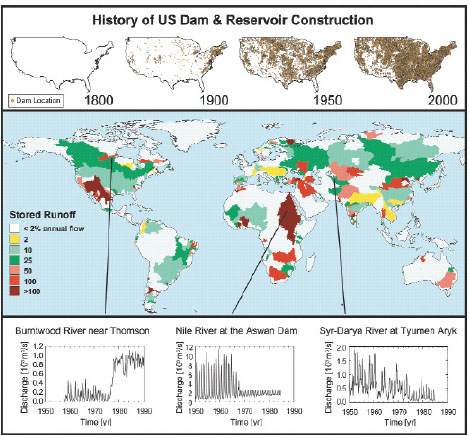
FIGURE 2-1 Alteration of the water cycle in the form of dams and canals is embedded deeply within the modern global water cycle. In the United States, the geographical extent of dams and reservoirs has increased dramatically over the past 200 years (top). This trend extends to developed parts of the world, with river regulation expanding rapidly in the 20th century (middle). As a result, human engineering and water use distort hydrographs (bottom). The left-hand graph is a purposeful interbasin transfer for hydroelectric production, the middle is the Aswan High Dam impact, and the right-hand is flow depletion due to cotton production in the Aral Sea contributing basin. SOURCE: Reprinted, with permission, from Vörösmarty et al. (2004). © 2004 by the American Geophysical Union.
The hydrologic cycle is altered by not only direct physical alteration, but also anthropogenic climate change; the most obvious symptom is the global redistribution of precipitation and the resulting change in surface water flow (Figure 2-2). In turn, changing the terrestrial branch of the water cycle impacts climate by altering the surface energy balance, changing evapotranspiration and surface reflectance characteristics. The hydrology of the land surface is affected directly by warming temperatures due to changes in snow and ice cover and shifts in vegetation patterns. The causes of hydrologic replumbing (land use change, hydrologic storage, climate change, etc.) are not independent and can yield compounding and cascading effects. For example, dam construction in arid regions impacts downstream hydrology and ecosystems, and additional stresses due to climate change challenge dam operations that strive to meet competing needs and further impact conditions downstream.
In addition to scientific issues, sociopolitical issues often take center stage. As an example, picture a semi-arid area of urban growth with limited water supply. Historically, water in many of these regions has largely supported agriculture, but in recent decades, the water needs of urban centers have become more dominant. When this shift in water demand involves transfer of water rights, tension between urban and rural areas can impact
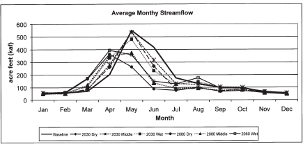
FIGURE 2-2 Average aggregate (based on seven upper Rio Grande basin tributaries) streamflow by month for six climate change scenarios. Three climate change models represent the range of possible climate outcomes for New Mexico (wet, dry, and middle) in 2030 and 2080. These projections illustrate that peak flow and total streamflow decline for all climate scenarios in this basin. In 2080, there is a pronounced shift in the peak runoff month, by about 30 days. SOURCE: Reprinted, with permission, from Hurd and Coonrod (2008). © 2008 New Mexico State University.
the amount of water available for agricultural communities. Infrastructure put into place to supply water for growing urban centers can impact surrounding ecosystems, creating an additional layer of tension. Finally, the impact of climate change introduces additional stresses on the hydrologic resources of the area.
In recognition of the human influence on the Earth system and in the context of Earth history, many scientists now call present times the “Anthropocene.” The traditional concept of the hydrologic cycle should perhaps by revised to consider humans as a significant and recognizable component. Research to further understand the human component of the water cycle, i.e., human-induced replumbing from both climate change and land use change, is recommended. This understanding is critical to providing and maintaining water supplies for humans and ecosystems.
How will water distribution and availability change because of hydrologic replumbing?
Water-related infrastructure has allowed many parts of the world to flourish, but at a cost to the natural environment and with growing and unintended impacts on society and ecosystems (Box 2-1). The relationship between human consumptive use and available water is not fully understood, yet this information is essential to understand how distribution and availability will change in the near and distant future. The hydrologic community can shed light on this relationship by probing how replumbing perturbs hydrologic fluxes. What are the impacts of groundwater overdraft on the surrounding hydrologic regime? Finding answers to questions such as this one will further the larger, societal goals of encouraging the best conservation behaviors and pursuing water-efficient products, both of which should be accomplished with the best possible scientific information to assist fair, legal, and scientifically sound decision making.
Conservation measures have been increasingly applied as water availability has become more limited, but even measures designed to conserve water can have downstream impacts. In some cases, agricultural return flows have become an important source of water, as exemplified well in the Cienega de Santa Clara, an open-water wetland in northern Mexico, which is supported by the return flows from the lower Colorado River basin. The Cienega is threatened by the Yuma Desalting Plant through which return flows would be diverted to the plant for desalination. Thus, actions that change the natural hydrologic system often have complex and interacting impacts and can create competition for highly limited available water. These include actions with direct impacts on the water cycle, such as changes in water use, as well as those with indirect impacts, such as forest clearing. What are the downstream consequences of replumbing in terms of the
amount and rate of flow and seasonality? What are the repercussions on both society and natural environments?
One recent focus has been on what is commonly called the “water-energy nexus” in which the human need for water is linked to energy just as tightly is the human need for energy linked to water. The procurement and delivery of water often requires energy for pumping, transport, desalination, and treatment. Likewise, almost all sources of energy, except perhaps wind, require water for some aspect of production (e.g., extraction, cooling, or conveyance), and many energy sources use considerable amounts of water. Of the freshwater used by the United States, 39 percent is used for electricity from fossil fuels and nuclear energy, and of that, as of 1995, 71 percent of that amount was used solely for the generation of fossil-fuel electricity (Solley et al., 1998). Oil shale and gas production, along with mining, have used a smaller portion of the freshwater in the United States, at 5 percent of the total withdrawn from surface and groundwater supplies. The increased use in the United States of biofuels, often touted as “green” energy sources (Box 2-2), provides another example. These uses highlight how increasing demands for energy correspond to increasing demands for water. The age of “separate but equal” resource planning for water and energy resources has passed—water is withdrawn and consumed during the life cycle of almost every energy source. What are the impacts of energy-related replumbing on water distribution and availability?
How will climate change influence the delivery of moisture (i.e., the severity, duration, and extent of droughts and floods)?
Climate change is expected to impact key hydrologic fluxes, most notably precipitation, which translates to impacts on the severity, duration, and extent of droughts and floods. A clear picture of the manifestation of climate change in floods and droughts has yet to emerge. Of course, increased vulnerability to hydroclimate extremes may be exacerbated by social and political factors, and having better scientific information may be of only limited value. For example, encroachment of construction in floodplains is a primary cause of increased damages (e.g., Pinter, 2005). Research opportunities exist, challenging the hydrologic community to provide better scientific information upon which social-political action will be required.
Flooding in the United States is linked to diverse regional climatologies of heavy rainfall. Extratropical cyclones, “atmospheric rivers” (Leung and Qian, 2009), rain on snow events, and convective storms are some of the most important flood agents in the western United States. Tropical cyclones, warm-season thunderstorm systems, and cold-season extratropical cyclones play important roles in the flood hydrology of the eastern United States (Smith et al., 2011), with their relative importance strongly dependent on
BOX 2-1
Is the North China Plain Running Out of Groundwater?
Groundwater overexploitation or persistent aquifer storage depletion is a worldwide phenomenon (Konikow and Kendy, 2005). Restricting their analysis to subhumid to arid areas, Wada et al. (2010) estimated that the total global groundwater depletion more than doubled from 1960 to 2000. The confluence of a multitude of factors, including rapid economic development, high population density, and climate change, makes the North China Plain (NCP) a compelling case study of a groundwater resource in peril (Zheng et al., 2010). The NCP refers to a relatively flat, low-lying alluvial plain in eastern China with a total area of 140,000 km2. It is home to the capital city Beijing and several other large cities including Tianjin and Shijiazhuang. Approximately 130 million people now live within the administrative borders of the NCP. With a population density of about 900 people per km2, the NCP is among the most densely populated regions in the world. The NCP is also critically important to Chinese economy, contributing about 12 percent of China’s gross domestic product and producing more than 10 percent of China’s total grain output.
The amount of exploitable water resource per capita in the NCP is in the “absolute water scarcity” category according to the “water stress index” (Falkenmark et al., 1989). Meanwhile, annual precipitation has steadily decreased by approximately 100 mm since the 1950s. In recent years, with dwindling surface water supplies, groundwater has become a primary source of water supply for the NCP. According to Zheng et al. (2010), more than 70 percent of the NCP’s total water supply comes from groundwater to support the region’s agricultural irrigation, industrial expansion, and population growth. The question is, how much longer can this be sustained?
The NCP sits on an expansive Quaternary aquifer system. The thickness of the NCP aquifer is tens of meters on the western piedmont areas but increases to hundreds of meters toward the eastern coastal areas. The NCP aquifer is commonly divided into two hydraulically connected units, referred to as the “shallow” aquifer and “deep” aquifer. During the “predevelopment” period until the 1950s, the water table of the shallow aquifer was usually no more than 3 m below the land surface in most of the NCP. Since the 1960s to 1970s, however, ever-increasing groundwater pumping has caused massive and continuing depletion in the NCP aquifer. According to the latest data from the China Geological Survey, the maximum depths to water in the shallow and deep aquifers exceeded 65 m and 110 m, respectively, in the shallow and deep parts of the NCP aquifer. Since the 1970s, groundwater levels in many parts of the NCP aquifer have declined at a rate of more than 1 m annually (Figure 2-3).
More than mere depletion of an invaluable natural resource, the overexploitation of the groundwater resource in the NCP has other severe environmental and ecological consequences, including dried-up rivers, land subsidence, seawater intrusion, and water quality deterioration (Figure 2-4). For the NCP’s main river, the Haihe River, the annual runoff to the Bohai Sea has decreased by threefold since the 1950s. Moreover, much of the surface water has disappeared. More than 4,000 km of various river channels in the NCP have dried up and the total size of wetlands has decreased to 20 percent of their level in the 1970s. Land subsidence
has also exerted a heavy toll on the region’s economic development, especially near the major industrial and coastal city of Tianjin where the maximum cumulative amount of land subsidence exceeded 3 m. For the NCP as a whole, a total area of 60,000 km2 has experienced a cumulative subsidence of 0.2 m or more.
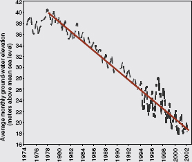
FIGURE 2-3 The long-term decrease in groundwater elevation at an observation well near Shijiazhuang City, Hebei Province, northern China. SOURCE: China Geological Survey (2009).
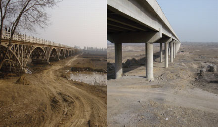
FIGURE 2-4 Eco-environmental consequences of groundwater depletion in China: a bridge over a dried-up river (left); former riverbed used for farming (right). SOURCE: Photos courtesy of Chunmiao Zheng, University of Alabama.
BOX 2-2
Water and Energy: Biofuels in the United States
Motivated by an increasing national interest in energy independence as well as concerns about the impact of greenhouse gas producing fuels, the United States has taken legislative steps to encourage the development of technologies that reduce dependence on these types of fuels. These steps include a new bioenergy program, which set the goal of developing technologies to generate biofuels that are price competitive with gasoline or diesel fuels. Although ethanol production could help achieve the national long-term goal of weaning the nation off greenhouse gas producing fuels, it comes at a cost to water resources, with regard to both water availability and water quality. Water is consumed not only in the production of crops to generate biofuels but also in the refineries that produce ethanol. Much of the water needed to cultivate biofuels relies on irrigation that taps limited surface and groundwater supplies, notably the Ogallala aquifer, and that compete with water supplies already used to support food production (NRC, 2007). An increase in the use of fertilizers to support additional crop yields for biofuel results in nutrient and pesticide pollution with corresponding impacts on water quality, including hypoxia, that endanger aquatic ecosystems (NRC, 2007).
The average water consumed in ethanol production, based on data from 19 states that produced ethanol in 2007, is 142 million liters of water for each million liters of ethanol, but this number is highly variable from region to region, ranging from 5 to 2,139 million liters (Chiu et al., 2009). The toll on regions where irrigation is necessary is evident. In 2003, a U.S. General Accountability Office survey indicated that many of the states that currently produce ethanol will experience water shortages over the next decade. Some of the states most likely to undergo shortages include those that consume the largest amount of water in the cultivation of corn and processing of ethanol, i.e., Colorado, Kansas, Oklahoma, and Wyoming (Chiu et al., 2009).
As of 2008, corn was used to produce more than 95 percent of the U.S. supply of bioethanol (EPA, 2008). Corn genetics research, water-conserving irrigation practices, and water pricing could help alleviate water stress in the production of corn-based ethanol (Chiu et al., 2009; NRC, 2007). Also, alternative sources of biofuels, such as sugar cane, oil seeds, the nonstarch parts of the corn plant, grasses, trees, and municipal wastes, may be less water intensive than corn and are being explored to determine their potential in terms of energy conversion efficiency and water quality impacts (NRC, 2007). Regardless of the source, the likely expansion of future production of biofuels has the potential to increase the demand for water in many parts of the United States (NRC, 2007).
drainage basin scale (Miller, 1990). Mesoscale convective systems have been the agents of extreme flooding in the central United States, notably during the Great Flood of 1993 and the Iowa flood of June 2008 (Coleman and Budikova, 2010). The Iowa floods were made worse by a heavy snow year resulting in greater than normal antecedent soil moisture for that
time of year which prevented the mesoscale precipitation from infiltrating. How heavy rainfall translates into flood frequency and magnitude requires substantial hydrologic insight. However, all of these processes leading to flooding may change as climate change alters the water cycle, so insight built from years of experience in watersheds is undermined by climate change and associated changes in heavy rainfall. Furthermore, changes to the landscape by humans will add to the challenge. Research is needed to assess how changing rainfall patterns coupled with changing land use can affect floods and their impact in the future.
Another consequence of climate change is a potential expansion and further drying of a semicontinuous band of aridity in subtropical latitudes. Temperatures in all regions are projected to increase, but an intensification of the equatorial to subtropical circulation, called the Hadley cell circulation, is expected to result in a poleward expansion of the global latitudinal bands of aridity (Held and Soden, 2006; Lu et al., 2007) and with further reductions in precipitation. The impacts of this increased aridity will be felt in regions such as the U.S. Southwest and the Mediterranean region of Europe, with related impacts on water supplies for human and natural systems. On a more regional scale, research suggests that the winter-spring storm track over North America may be retracting poleward earlier in the season, leading to reduced spring precipitation in the western United States, a shift consistent with climate change projections under warmer conditions. Also, the moisture variability and occurrence of drought in regional climates in many parts of the world are strongly influenced by El Niño/ Southern Oscillation (ENSO), a coupled ocean-atmosphere pattern of circulation in the tropical Pacific Ocean associated with climate in many parts of the world. In fact, the relationship between precipitation and ENSO is chaotic in some regions. In the California Sierra Nevada, for example, El Niño years are either wet or dry but generally not near the median. But research results do not agree on the impact of climate change on ENSO, and therefore this issue remains to be resolved. Planning for future water resources in these regions should evolve in the face of an anticipated reduction in precipitation. Research is needed, for example, to determine optimal measures for water management as precipitation declines.
Additional factors can amplify the impacts of climate change. For example, depending on location and climate regime, glacier meltwater provides essential water resources throughout the year, and in some locations it acts as a supplementary water source in the summer. Glacier loss due to climate warming and other factors could impact water resources in these areas, especially semi-arid and arid regions. Although many glaciers have exhibited recession over recent decades, with the highest retreat exhibited in glaciers at lower elevations, the rates of retreat can vary widely as regional factors (precipitation, aerosol concentration, etc.) affect glaciers in addition
to warming. Regardless, the possibility exists that regions dependent on glacial melt will face increased periods of water shortage, with increases in both frequency and severity of drought. As the glaciers recede, basic research probing the major impacts on water supplies and flow regimes should be pursued. What modeling efforts are needed to better understand the connection between changes in the upstream glacier-water catchments and available water resources downstream? What new technologies, either airborne or spaceborne, can be used to further understand and characterize the human impact on the world’s glaciers?
A “grand challenge” thus faces the climate and hydrologic sciences communities—to understand the nature of ongoing changes in climate and hydrology and the apparent anomalies that exist in reconciling their extreme manifestations.
Global Change and Extreme Hydrology: Testing Conventional Wisdom,
NRC, 2011
More broadly, human-caused modifications of the water cycle through climate change can promote feedbacks that push the climate into new regimes. It has been speculated, for example, that climate change has removed the climate system out of the repeated cycle of glacial-interglacial episodes. Understanding the scope and nature of hydroclimate changes requires reliable, long observational records, accurate results from global and regional circulation models, and a full understanding of the causes of climate mode shifts even under natural climate variability.
The committee challenges the hydrologic community to reduce the gaps in knowledge of how the hydrologic cycle will respond to climate change. More specifically, how will changes in precipitation patterns affect the flow between and storage of water in the world’s hydrologic reservoirs such as glaciers, lakes, rivers, and aquifers? How will changes in these reservoirs amplify or buffer regional hydrologic variability and change? Where, when, and how will couplings between reservoirs affect water resources?
What are the challenges in developing and using regional climate change projections for assessing future hydrologic change and impacts?
Long-term water resource management involves anticipating changes in demand and supply. Predicting basin-scale changes in water availability in response to climate change and hydrologic replumbing remains an obstacle to effective water resources planning and management. To extrapolate
from what is known about global climate change to how flooding will increase in a given river basin years in the future so decision makers can, for example, identify a safe location for a nuclear power plant, involves numerous components (models, observations, etc.) appropriately linked with uncertainty minimized. Similar challenges exist to predict how climate change will affect regional water availability. For example, in a Mediterranean climate such as California, earlier snowmelt and precipitation that falls as rain instead of snow because of warming can result in less water in storage during the peak water demand season, which in turn stresses groundwater supplies. Runoff projections require coupling of climate models at both the global and regional scales, which feed into hydrologic models and often then into planning and operations models. Furthermore, it is now well known that important feedbacks to climate can occur from terrestrial hydrologic processes such as soil moisture and groundwater fluctuations, necessitating coupling of hydrologic and climate models for improved climate projections.
Global climate models (GCMs) have improved significantly over the past decades, with increases in spatial resolution and the incorporation of expanded hydrologic and biogeochemical processes into many models. Certain aspects related to the water cycle could still be modeled better, including cloud and cryosphere feedbacks and extreme precipitation events. At the regional scale, methods are being refined that use statistical and dynamical downscaling of GCMs to the scales relevant to climate change adaptation planning. At the watershed scale, hydrologic simulation models are used to project future conditions by incorporating downscaled GCM output. Challenges remain concerning the scalability of model behavior and generalization of results to watersheds with different characteristics. These linked challenges can be illustrated by a suite of studies that have targeted the Colorado River basin to reconcile projected changes in runoff during the next 50 years. Several different research groups using different sets of models, modeling approaches, and output recently narrowed the spread of projections from a 5 to 45 percent reduction to a 5 to 20 percent reduction in annual flow, a range that is still rather broad for useful planning purposes but nonetheless capable of exposing vulnerabilities in current management plans (Christensen and Lettenmaier, 2006).
Thus, uncertainties result from a chain of cascading factors, from the GCMs used, to how output is downscaled, and to the type of hydrologic model used to produce runoff projections. For operations and planning, the hydrologic output is then routed into operations models that include effects of increasing demand, changes in land use, legalities, and socioeconomic factors, all of which present additional uncertainties. The scientific challenge is significant and complicated by the fact that hydrologic science is not the only discipline needed to address the issue. Yet in essence, hydrolo-
gists and engineers have entered a new era in which quantitative analysis of the entire terrestrial hydrologic cycle is becoming possible. To promote this possibility, research to further integrate hydrologic models as well as to couple them with climate models is suggested.
To generate more useful hydroclimate projections from models, the following key research questions should be tackled: What is the capacity for models to project the frequency and magnitude of seasonal and longer periods with high precipitation or drought similar to that documented in paleoclimate records? Can model projections incorporate the impacts of human activities on regional climate and thus be more useful for management and planning? Embedded in many of these challenges is the need for hydrologists and other scientists to engage and interact with water resource professionals to solve problems related to the availability of adequate water quantities and quality for humans and natural systems. Although this is further discussed in Chapter 5, a few relevant questions are posed here: What are the most productive approaches for bringing together scientists and decision makers to address sciences questions that are relevant to planning and policy? How can management strategies be refined in the face of known uncertainties in regional climate variability and change? What educational programs are needed to train the next generation of hydrologic and climate scientists who are capable of both integrating the appropriate sets of hydrologic and climate measurements and fully coupling hydrologic and climate models to estimate future water resources availability?
2.2. Critical and Unknown Hydrologic Fluxes
Evaporation, transpiration, and groundwater fluxes interconnect the water, energy, and biogeochemical cycles and are conditioned by human impacts on the water cycle.
The water balance, incorporating land evaporation and transpiration (evapotranspiration) and groundwater fluxes (recharge and discharge), to the first order, determines the distribution of vegetation. In other words, these fluxes connect the water cycle and the biosphere, in addition to connecting the slow (subsurface), surface, and fast (atmosphere) components of the terrestrial water cycle. The time scales of the underground, slow components of the water cycle span decades. In contrast, the memory of the atmospheric branch is only days to weeks. By linking these disparate components, the fluxes serve as important regulators of the water cycle’s dynamics. Land evaporation and recharge are directly relevant to the determination of the limits of sustainable irrigated agriculture and aquifer use. Recharge, as the rate of aquifer replenishment, is a key determinant of
the sustainable rate of aquifer pumping. Maintaining land evaporation at a rate that does not stress vegetation is the primary factor that determines sustainable crop production and healthy ecosystems.
Understanding the processes that link the components of the water cycle is no less important than understanding the human impact on the water cycle itself. This understanding requires direct information on the patterns and dynamics of evapotranspiration and groundwater fluxes. Currently scientists do not even know the climatology, i.e., the average spatial and temporal characteristics, of fluxes over large land regions (Jiménez et al., 2011; Mueller et al., 2011). Yet the necessary tools for making progress in this area are close at hand. Spaceborne sensors can be deployed that map the state of surface soil moisture, surface temperature, water storage in Earth’s crust (Box 2-3), and other conditions related to the hydrology of the land surface that impose important constraints on the estimation of evaporation and recharge. Two examples of important research questions are presented below.
What types and mixtures of remote sensing measurements, ground-based measurements, and modeling can be designed to yield estimates of evaporation and recharge fields at the landscape, regional, and continental scales?
The flux of water from the land to the atmosphere is complicated by the fact that much of it occurs through plants or as transpiration. The control of plant physiology over transpiration is difficult to deduce because of the complexity of biology and diversity of life. Furthermore, the turbulence generated in the boundary layer at the interface of the land and atmosphere is a key determinant of evaporation and transpiration. The difficulty in characterizing how turbulence is generated at solid-fluid interfaces—especially when the solid is rough, porous, flexible, and irregular—poses a challenge for mapping evaporation. Will improved understanding of plant physiology yield better understanding of how plants influence the water cycle? Can modeling strategies that advance understanding of flow through porous media improve estimates of evapotranspiration?
Evaporation and recharge are important to Earth’s metabolism through more than just the water cycle. Evaporation is also part of the energy and carbon cycles and recharge is part of several biogeochemical cycles. Therefore, observations of many variables, such as land surface temperature, atmospheric carbon dioxide content, isotopes of carbon, and water and other compounds, can provide important information about evaporation and transpiration in addition to measurements routinely used to make estimates simply using the primary water-balance components, precipitation and stream flow. Models that simulate as well as integrate observations
BOX 2-3
Gravity Recovery and Climate Experiment
Measurement of Changes in Earth’s Water Mass
The Gravity Recovery and Climate Experiment (GRACE) is a twin satellite mission launched in 2002 by the National Aeronautics and Space Administration (NASA) and the Deutsche Forschungsanstalt für Luft und Raumfahrt.a The purpose of the mission is to map variations of Earth’s gravitational field at approximately monthly intervals using global positioning system (GPS) and a microwave ranging system to make accurate measurements of the distance between the two satellites. Because the largest contribution to the change in Earth’s gravitational field is from changes in distribution of water and snow, hydrologists use GRACE data to estimate changes in water storage at regional and global scales. Availability of GRACE data has contributed significantly to calculation of large-scale water balances that now can include a subsurface component.
A striking example of an application is the calculation of the amount of water flowing through the Amazon River basin (Figure 2-5). Other applications include detection of anthropogenic changes; recently GRACE data were used to confirm groundwater depletion over northern India resulting from unsustainable consumption of groundwater for irrigation (Rodell et al., 2009). In addition, several studies point to the feasibility of using GRACE data for subcontinental and regional-scale assessments. Examples include the High Plains aquifer (Strassberg et al., 2007), the state of Illinois (Swenson et al., 2006; Yeh et al., 2006), and the Mississippi River basin and its subbasins (Rodell et al., 2007).
FIGURE 2-5 Selected illustrations of monthly water changes over the Amazon and neighboring regions. The distinct rainy and dry seasons of the Amazon show up clearly in these monthly maps (left, April 2005; right, October 2005). SOURCE: Reprinted, with permission, from Crowley et al. (2008). © 2008 Springer Science + Business Media.
____________
will need to evolve to incorporate new observations. Data assimilation, the systematic blending of observations and models, can progress to finer time and space scales as computing power increases and assimilation methods and models become more sophisticated. Data assimilation offers the potential for developing physically coherent, observationally constrained data sets that depict Earth’s combined water, energy, and biogeochemical cycles. What are the key uncertainties that impede improved assimilation outcomes for hydrologic variables? How can assimilation make optimal use of coupled biogeochemical cycles to limit uncertainty in hydrologic fields?
The number of spaceborne and airborne platforms are growing, and the data streams from the instruments located on these platforms can contribute to estimates of the key land-surface fluxes—where water is going in all of its phases (Box 2-3). The mapping capability of these platforms is particularly suitable for spatially extensive estimation. Furthermore, advances in sensor technologies now allow measurements with spectral resolution that can sense complex chemicals; the combined estimation of water and biogeochemical fluxes may improve accuracy of measurement of both. In situ sensor developments—including those relying on remote sensing such as acoustic, seismic, and electrical geophysical exploration—allow new and detailed types of measurements that are relevant to characterizing evaporation and recharge. The hydrologic community should not only adopt emerging sensors but also guide the development of their next generation. How should the community implement new testbeds for technology development that focus on developing and cross-testing emerging sensor technologies? What community field experiments are needed to determine key unknowns? What principles from theory should guide campaigns of observations?
How are groundwater fluxes coupled to surface landscapes and waterscapes?
Recharge fluxes, from Earth’s surface to groundwater, are notably difficult to characterize. Recharge occurs deep in the soil column beyond immediate reach. It can be focused in some narrow conductive corridors that are difficult to find and map. Recharge also can be diffuse but occurs at rates so small that it requires deployment of sensitive sensors at depth, a difficult technological task. Finally, focused recharge can be intermittent in time and short lived.
Discharge fluxes, from groundwater to Earth’s surface, occur to streams and rivers, lakes, and the ocean, to the land surface itself in springs and seeps, or directly to plant roots that emit water into the atmosphere via transpiration. Groundwater discharge also can originate from recharge at distant locations in other watersheds connected by long, groundwater flow paths. Groundwater discharge is measured more often than recharge
because it tends to be geographically more focused or localized. Nevertheless, because of its distributed nature, extensive data, or even appropriate measurements, are commonly not available. Therefore, knowledge of spatial and temporal patterns of discharge is therefore fragmentary at best. Groundwater development has resulted in another major groundwater discharge mechanism, the pumping from wells. Knowledge of well pumping rates is also fragmentary because they are seldom measured (NRC, 2004).
Groundwater fluxes at interfaces depend on land cover, climate, soil and rock properties, and topography. Hydrologists traditionally have worked to understand how these factors “control” fluxes. In a larger sense, however, groundwater fluxes impact the development of the soil, land surface, vegetation and soil biota, topography, and climate. Thus, developing a fuller understanding of groundwater fluxes at interfaces, at least over time scales beyond the hydrologic year, present very interesting scientific challenges. For example, groundwater discharge occurs in wetlands with extensive peat. How do fluxes sustain the low-oxygen environments necessary for peat formation? If groundwater fluxes in these systems decline, how does the drying of peat in turn affect water (and nutrient) fluxes? There are poorly understood connections between climate and groundwater fluxes. Changes in both temperature and precipitation affect infiltration and thus patterns of diffuse groundwater recharge. How does climate change over the span of years or decades alter the water balance at Earth’s surface and lead to changes in vegetation patterns and consequently a variety of surface processes? Conversely, near-term changes in recharge can have large impacts on groundwater discharge in the distant future. Can the relationships between groundwater and climate be discerned through the careful study of paleohydrology?
Groundwater fluxes at interfaces can often be inferred using remote sensing, typically during times when the temperature of discharging groundwater is much different than the temperature of the surface water body. These data provide information about broad patterns of discharge. To fully quantify discharge, the remote sensing patterns should be linked with field measurements made at discrete locations. Integration of information and data generated at different scales is essential to learn about details of process and pattern. How do the measurements at small scales translate to observed variability as one moves up in scale? What are the essential elements of a research program for improving estimates and measurements of groundwater recharge and discharge across scales? To quote from a National Research Council (NRC) report on recharge and discharge, badly needed is:
the development of sensors that measure recharge and discharge at “point” scales, research to increase our understanding of the scaling of these measurements
and underlying processes, the development of procedures for integrating measurements and observations across scales, and generation of mathematical tools to assimilate and synthesize observations at all scales into groundwater process models (NRC, 2004).
2.3. Understanding Variability at Multiple, Coupled Scales
Processes that define water fluxes occur at the scale of turbulent gusts of wind to large weather systems and from the scale of the first drops of water that initiate streams to the complex system of rivers that define drainage basins.
The past few decades have witnessed not only major advances in understanding and modeling the space-time variability of hydrologic processes including precipitation, soil moisture, and streamflow, but also, more importantly, development of conceptual frameworks for describing this variability across a wide range of scales, from physical, phenomenological, and statistical perspectives. For example, empirical evidence from several watersheds of different physiographic and hydroclimatic conditions has for decades demonstrated how “self-similarity” or “scale invariance” in mean annual streamflows manifests itself in simple power-law relationships, generally referred to as scaling laws. Although the scaling of mean annual flows (with exponent of approximately 0.5 to 0.6; e.g., see Figure 2-6, bottom panel) has been attributed to the topologic structure of river networks, the physical origin of scaling laws for specific storm hydrograph peaks (e.g., the emergence of scaling with exponent of 0.79 for the storm of June 2008 in Figure 2-6, middle panel) remains an unsolved problem. Because observations cannot be made all the time and everywhere in a watershed and because physically based distributed hydrologic models require extensive data for calibration and verification, such simple scaling predictive theories are not only of theoretical interest but also of immense practical importance.
The committee presents two important problems that further challenge predictive understanding of hydrologic variability across a range of scales, from small subbasins of a few square kilometers to large basins of the order of tens of thousands of kilometers. The first relates to the dynamic connectivity of landscapes, from hillslopes to the subsurface and to fluvial river networks, and how it may manifest in scaling theories of hydrologic response. The second relates to human amplification of natural variability and change over a range of spatial and temporal scales.
FIGURE 2-6 Emergence of scaling in both mean annual floods (bottom) and storm-specific floods (middle) in the Iowa River Basin. The 32,400 km2 Iowa River basin has 29 daily recording U.S. Geological Survey stream gauges (top) forming the basis for the scaling plots shown (middle, bottom). The mean annual peak flow scaling reflects the topologic structure of the river network, but understanding the scaling of the observed peak flow for the storm of 2008 remains a challenge. Empty circles are locations where stream gage records are affected by upstream regulation or replumbing. Note that the middle panel corresponds to the catastrophic flood of June 17, 2008, which resulted in total damage of 10 billion USD, caused 85 counties to be declared disaster areas by the President, and displaced 40,000 people. SOURCE: Modified, with permission, from Gupta et al. (2010). © 2010 by the American Geophysical Union.
How do flowpaths along hillslopes and the subsurface, which connect to the stream network intermittently in time and with spatially variable extent, influence runoff dynamics over a range of space-time scales?
Understanding how processes at the small scale (hillslope) interact with those at the larger scale (networks) to describe the entire hydrologic response of river basins and the possible emergent scaling laws for specific rainfall-runoff events remains elusive. Analysis of the connectivity of the river network to the three-dimensional landscape within which it is embedded (e.g., intermittent exchanges between riparian and stream zones (Figure 2-7), dynamic surface-to-subsurface interactions, and space-time variable contribution of hillslopes to streams) has exposed the limitations of current conceptual theories that attempt to generalize hydrologic response as a function of scale.
FIGURE 2-7 An illustration of hydrologic connectivity in terms of the upstream accumulation area (UAA; shaded) for a location and the percentage of the water year for which there exists hillslope-riparian stream (HRS) water table connectivity along the left (red bars) and right (black bars) sides of the Tenderfoot Creek network, Montana. The predicted hydrologic connectivity ranges from 0 to 100 percent of the year (represented by bar heights) and is a first-order control on the catchment scale runoff dynamics. SOURCE: Reprinted, with permission, from Jencso et al. (2009). © 2009 by the American Geophysical Union.
The nature of dynamic pathways that connect the unchannelized part of the basin (98 percent of the landscape) to the river network (hardly 5 percent of the total landscape area)1 is complex and carries the signature of the space-time variable storm structure as well as the soil and vegetation dynamics of the basin. Yet, general organizing principles still exist, and observations suggest that scaling laws in streamflows might still apply at the storm scale, reflecting a generalized scale invariance of the co-evolving system. Process-based theories of hydrologic response on “extended” networks (encompassing hillslope, subsurface, and fluvial flow paths) should be developed, aided by new high-resolution topography data via light detection and ranging (LiDAR) and verified by detailed hydrologic observations over a range of space-time scales and climates. These new approaches can address a variety of research questions. For example, how can dynamic pathway connectivity and space-time variable precipitation be incorporated into a generalized scaling framework of hydrologic response? Can the static template of the river network be transformed into a dynamic template (expanding or contracting or disconnected network of paths) over which flows and other fluxes are organized over a range of space and time scales? Finally, can network theories be adopted for dynamic (space-time) scaling of fluxes and how could the scaling parameters emerge from physical properties of the system?
Given that interactions at overlapping scales change hydrologic patterns in subtle ways, how can hydrologists disentangle human-induced landscape changes from the observed hydrologic response?
Human impacts on the landscape, such as clear-cutting, increased fire frequency, land use changes, and replumbing of the landscape via surface tilling and subsurface tiling2 for increased crop production, are changing delivery of water to streams. A changing climate further modifies the landscape. The result is a streamflow signal that differs from previous decades (Figure 2-8). A challenge of theoretical and practical interest is to develop a predictive understanding of the two-way interactions between human impacts on the landscape and the climate system and how these impacts may manifest in the hydrologic response. For example, what changes in streamflow patterns are attributable to changing precipitation patterns, changing crop practices, or both, and how can they be disentangled and predicted in the future? What magnitudes and frequencies of human-induced landscape
____________
1 These values are estimates based on committee experience with drainage density and channel width as inferred from light detection and ranging (LiDAR).
2 Subsurface tiling is a piping system underneath agricultural lands for draining excess water.
FIGURE 2-8 Seven streamflow characteristics in the Minnesota River basin, showing substantial increase in recent decades. Values are 5-year running averages normalized by 1950-2002 mean values. These changes involve a mix of variability on different time scales, suggesting multiple, intertwined causes. SOURCE: Modified, with permission, from Novotny and Stefan (2007). © 2007 by Elsevier.
changes are mostly amplifying natural change? How can early warnings of critical transitions or regime shifts be identified?
Not only is the causality of subtle shifts and regime changes in streamflow important, but understanding the environmental impact of changing streamflows is at the heart of predicting environmental changes. More frequent occurrence of high streamflows increases bank erosion and fine sediment delivery to streams, altering water quality and impacting aquatic life. Higher flows also incise streams, isolating them from their floodplains and reducing their capacity to absorb environmental stresses, such as removal of nitrogen and other nutrients. Similarly, altered frequency of low flows affects stream water quality, biogeochemistry, sediment transport, and river life. Understanding causes and patterns of changing hydrology is necessary for understanding changes in streamwater quality and aquatic life—posing new challenge frontiers at the interface of hydrologic sciences with sister natural sciences as well as with management and policy. Can human-induced hydrologic changes be regulated to minimize changes in stream ecosystem functioning? How are natural and anthropogenic changes modulating each other nonlinearly to amplify or dampen environmental change? Are high and low flows equally affected by human-induced changes, and
how can change be understood as a function of both magnitude and frequency? Multiple stream processes combine to produce the net effect on water quality and aquatic life. What are the feedbacks among these coupled processes? Are some of these processes more sensitive to changing streamflow than others? Which ones are the most important to target for reducing negative impacts on water quality and aquatic life?
2.4. Timescales of Hydroclimatic Variability and Change
The climate system can vary at long time scales as well as shift rapidly into new modes of behavior that are radically different from the historical experience, resulting in large hydrologic changes.
Hydrologic processes are largely driven by climatic factors that vary over multiple time scales. Understanding of abrupt changes over short time-scales and changes that vary over multidecadal to millennial and longer time scales is far from complete. The climate of the near and far distant past holds knowledge of causes and drivers of climate variations and their impacts on hydroclimate. This understanding is critical for generating future scenarios of hydrologic variability (e.g., runoff and recharge) that include both natural variability and human impacts on climate.
Slowly varying natural climate behavior is driven by similar conditions in the world’s oceans and their interactions with the atmosphere. A number of recognized ocean-atmospheric circulation patterns appear to vary on decadal and longer time scales. Some of these are linked to known dynamics, such as ENSO, while the causes of others are less clear bur may be inherent, internal, ocean-atmosphere dynamics. Decadal variability in north Pacific Ocean sea-surface temperature interacts with ENSO, enhancing and diminishing its teleconnection effectiveness depending on phase. In the Atlantic Ocean, the Northern Atlantic Oscillation, a pressure seesaw between Iceland and Portugal’s Archipelago of the Azores, appears to vary on both short and long time scales, while the leading mode of sea-surface temperature variability in the North Atlantic appears to vary on multidecadal time scales, possibly paced by the thermohaline circulation.
These interactions between the world’s oceans and the atmosphere, whether the drivers are fully understood or not, have strong links to hydroclimate variability in many regions of the world. Developing a more complete understanding of these slowly varying influences is important for anticipating how climate change trends will interact with natural climate variability at long time scales. Because instrumental and gauge records are
typically only 100 years long or less, paleoclimatic data are critical for developing this understanding.
The definition of abrupt climate change depends partly on context, but the committee adopted the following a generally agreed-upon definition:
a large-scale change in the climate system that takes place over a few decades or less, persists (or is anticipated to persist) for at least a few decades, and causes substantial disruption in human and natural systems (U.S. Climate Change Science Program, 2008).
These rapid changes in climate that affect the cryosphere and hydrologic variability present a number of challenges and research opportunities for the hydrologic sciences.
The impact of rapidly changing climate on hydrologic processes is greatly enhanced in regions where the cryosphere plays an important role in water storage. Abrupt events could lead to changes in the timing and volume of snow and icemelt in mountainous and polar regions where snow is an important component of the hydrologic cycle. If the large areas of permafrost (perennially frozen ground) thaw, then there may be an increase in discharge from polar rivers. A rapid disintegration or melting of glaciers, ice caps, and the major ice sheets in Greenland (Figure 2-9) and West Antarctica in response to warming could have major consequences for sea level. Recent estimates based on glaciological constraints suggest that a potential sea level increase of as much as 2.0 m is physically possible by 2100, but that an increase of ~0.8 m is more likely (Pfeffer et al., 2008). A rapid rise in sea level would not only inundate low-lying coastlines but also dramatically affect coastal aquifer systems and increase erosion even in areas where inundation is not a problem.
Other examples of abrupt change with critical impacts on the water cycle include extreme and protracted droughts and episodes of regional flooding. Both events are influenced by shifts in the ocean-atmosphere systems that control the delivery of moisture to a region. Drought that evolves more rapidly than can be accommodated by adapting human or natural systems, even if not permanent, can threaten the survival of societies and ecosystems. Drought can be prompted by changes in large ocean-atmospheric patterns of circulation, such as those generated by ENSO. A persistence of the cool phase of ENSO, which results in drought across much of the southwestern United States today, is hypothesized as a reason for the increased aridity in the western United States during the medieval period. The warm phase of ENSO can result in episodes of regional flooding, exposing societies and ecosystems to risk, in regions such as southern California and the states along the Gulf of Mexico.
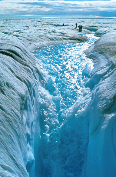
FIGURE 2-9 Flowing meltwater on the surface of the Greenland ice sheet. Some of this water goes into the ice sheet through features called moulins, eventually reaching the bottom, where it may promote more rapid flow of the ice. Meltwater and moulins have been occurring at higher and higher elevations over time. SOURCE: Reprinted, with permission, from Roger Braithwaite, University of Manchester and Specialiststock.com.
How will future changes in the water cycle, influenced by human activities, take place in the context of slow but significant natural variations in the climate?
The Earth-atmosphere-ocean system is inherently complex, and ocean conditions vary relatively slowly (because of the rate at which water gains and loses heat) compared to the atmosphere. This results in climatic and hydrologic variability over a wide range of time scales, including the decadal to century scales that are critical to water resource decision making and infrastructure planning. Although human activities will impact the future trajectory, the low-frequency natural variability operating on interannual to centennial scales and longer will persist, underlying anthropogenic climate change (Figure 2-10). This low-frequency variability has the potential to either exacerbate or mitigate the impacts of human-induced trends, such as warming, on hydroclimatic variability and extremes. GCMs currently do not reproduce well the observed low-frequency variability, necessitating the use of both long records of natural variability and information from GCMs for plausible projections of future climate and hydrology.
ENSO is one of the best-understood, large-scale drivers of regional climates and hydroclimatic variability, and it influences climate in many parts of the world. Understanding of ENSO, which operates on time scales of roughly 2-8 years, had led to the ability to produce useful forecasts for the regions with the strongest teleconnections to ENSO. Other more slowly varying climate modes, such as the Pacific Decadal Oscillation, the Arctic Oscillation, and the Atlantic Multi-decadal Oscillation, are also known from the observational record. Couplings among these modes of variability for hydrologic processes are understood to some extent. For example, the low-frequency component of ENSO, commonly recognized as Pacific Ocean decadal variability (or the Pacific Decadal Oscillation, PDO), appears to reinforce or weaken the regional impacts of ENSO at decadal time scales. For regions that are not strongly or consistently affected by ENSO, the PDO, or other well-studied decadal variability, research is needed to determine other drivers of low-frequency climate variability. This includes the jet stream, as well as patterns of high and low pressure that set up and persist seasonally. Understanding and anticipating low-frequency hydroclimatic variability would allow for resource management and planning that take advantage of intervals of more favorable conditions to prepare for intervals that place more stress on resources.
In many cases, instrumental records of climate are too short to evaluate and investigate hydroclimatic variability at multidecadal and longer time scales. Paleoclimate data, particularly from tree rings and other high-resolution data, have proven to be valuable for reconstructing past modes of climate variability. In many cases, reconstructions of ocean-atmosphere
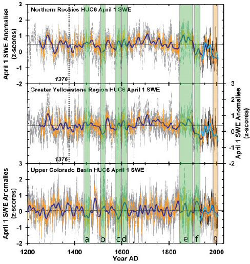
FIGURE 2-10 Reconstructions of snowpack in the northern and central Rocky Mountains from tree-ring data. The graphs of the April 1 snow water equivalent (SWE) reconstructions show multiple watershed reconstructions (gray lines) within each larger region, with the regional average (orange line), smoothed (dark blue line). For the Northern Rockies and Greater Yellowstone region, the reconstructions are most reliable after 1376 (dotted vertical line). The 20th-century records of observed April 1 SWE are also plotted for each large region (black lines) and smoothed (cyan line). Shaded intervals show decadal-scale SWE periods highlighted in the full paper. The observed and reconstructed SWE records are plotted as anomalies from the long-term average. These records indicate that wet conditions in the northern Rockies and Yellowstone region tended to coincide with dry conditions in the Colorado River basin over the past centuries. However, this natural variability at 20- to 50-year time scales has been more synchronous because of late-20th-century warming, resulting in a decline in snowpack across all three major watersheds. SOURCE: Reprinted, with permission, from Pederson et al. (2011). ©2011 by the American Association for the Advancement of Science.
circulation use land-based proxies that imply moisture transport from remote locations and have some utility. What types of paleoclimate data can be better exploited to indicate behavior for regions, such as the oceans, that are relatively data scarce? Notable features of past climate, such as the droughts of the medieval period, contain information that may be useful for anticipating the future, but understanding the global climate context for these droughts would be even more valuable. Can multiproxy records (records from multiple sources that document climate, such as tree rings, lake sediments, and ice cores) of past climate, along with climate modeling, be used to simulate global climatic variability and its drivers during anomalous periods, such as the medieval period? Much focus has been placed on the tropical Pacific Ocean variability, and with good reason, but is it possible to develop robust ensembles of paleoclimate reconstructions of modes of climatic variability in other parts of the world as well? Finally, how can paleoclimate data be best used to disentangle the low-frequency natural variability from trends due to climate change, and can this information be used to inform the range of hydroclimatic conditions that can be expected in the future?
Hydrologic systems, particularly the large reservoirs that contain water storage that equals several years of accumulated flow, may have different time scales of response compared to the combined effects of seasonal, annual, and multiyear climate variability. Low-frequency variation in hydroclimate superimposed on trends in temperature may affect the impact of drought in such managed hydrologic systems. Understanding the low-frequency variability and its impacts is critical for managing water supplies under a variety of scenarios. Can modeling be used to produce ensemble projections of hydroclimatic variables for use in water resource decision making? Some use has been made of paleoclimate data in assessing long-term reservoir operations under a broader range of conditions than that provided by the gauge records (e.g., Lower Colorado region, Bureau of Reclamation). How can these applications be expanded to use the low-frequency information in paleoclimate records, along with projections for future climate change, to present a plausible range of conditions?
What causes “tipping point” transitions of the climate and what are the hydrologic implications?
A tipping point with global implications is a transition from what is now occurring to an entirely new climate state or a point where abrupt climate change occurs. Earth’s climate system has shown some evidence of regime behavior, most notably the potential to exist in at least two different states even with the same solar forcing, such as states with or without a thermohaline circulation. A shift in the climate regime from one state to another would have huge implications for many aspects of the hydrologic
cycle, including the behavior of the cryosphere, surpluses and deficits in surface water reservoirs, and the frequency of extreme hydrologic events such as floods and droughts.
As climate models have become more complex, the spread of their projections of future climate has tended to widen, suggesting that increasing the number of processes included in the models reduces the predictability of the climate system. This also suggests that positive feedback processes not yet studied or modeled may amplify some fluctuations in the climate system. If the amplifications are large enough, they could push the climate system into new modes of behavior or induce an abrupt change. Furthermore, paleoclimate records have revealed past episodes of rapid change to new climate regimes. There is value in understanding the past frequency of such “abrupt” episodes and the processes that caused them, but this requires relatively long records. Refinement of records extending back hundreds to many thousands of years is needed to provide clarity on how natural processes, acting alone or in conjunction with human-caused factors, may yield rapid climate change in the future. Paleoclimate analyses that document abrupt climate change under natural climate variability (Overpeck and Cole, 2006) coupled with improved hydroclimate modeling will provide insights into causes and consequences of climate transitions and their hydrologic implications. Because models likely do not contain the feedbacks that trigger tipping points that are documented as abrupt changes in the paleoclimate record, scientists still lack the information needed to understand and anticipate tipping point transitions. What modeling improvements and paleoclimate data are needed to understand and project potentially catastrophic abrupt changes in a warming climate?
2.5. Exohydrology
The presence of water in and on planets changes everything—from deep interior dynamics to the surface evolution of landscapes to the potential for life.
The recent exploration of Mars has popularized the idea of “following the water” to look for life on other planets. Life occurs nearly everywhere on Earth’s surface and, surprisingly, microbial life may occur even deep in Earth’s wet underlying bedrock, perhaps as much as 5 km into the igneous rock underlying the oceans. There may even be more biomass in this deep rock reservoir than in the overlying oceans and on the entire land surface.
Of course Earth is a water planet, with 71 percent of its surface area in oceans. Earth is blanketed in a watery atmosphere and washed by rain-
storms and snowmelt. What is less appreciated is that the dynamics and composition of the entire solid planet are affected by the distribution and abundance of water. There is a deep water cycle. The motion of mobile plates of crust that collide, creating mountains, and separate, making ocean basins, depends on water in the underlying mantle (with some of that water coming from subduction of wet ocean slabs). Water deep in the planet affects its chemical evolution and its internal dynamics. The abundance of granite on Earth records the extensive mixing of water with basalt and other rocks. The nature of volcanic eruptions and the movement of faults are strongly influenced by water. Ultimately, water weathers bedrock, and erodes, transports, and deposits mass, some of which is subducted with the ocean floors and enters the mantle. Hence, the water cycle, including the deep water cycle, strongly influences the composition and dynamics of the planet and likely the same is true on other water-rich planets (Marcy, 2009).
When society explores other planets, then, a key goal is to quantify the abundance and dynamics of water, not only to determine the possibility of life elsewhere but also to understand how the entire planet operates. The recent discovery of planets beyond the solar system has led to new models of the positioning of planets and their size and composition relative to their sun. The presence of water is central to predicting the composition and dynamics of these planets, as well as to the potential for “habitability.”
The study of hydrologic processes on other planets could be termed “exohydrology” and it is only just beginning. As a sign of the current importance of this topic, the American Geophysical Union convened a session at the fall 2011 meeting titled “Follow the Water: Insights into the Hydrology of Solar System Bodies.” There is also a literature developing on exohydrology (e.g., Andrews-Hanna and Lewis, 2011). Although exohydrology is necessary to understand the evolution and climate of other planets, it also offers a test of the understanding of how Earth works. Abundant new imagery has presented startling observations of river channels, alluvial fans, gullies, and deltas on a planet where surface liquid water is currently absent (Mars) and channels, lakes, and rain driven by condensing and evaporating methane (Titan). The committee suggests two important research questions that focus on surface water processes. These questions present challenges that are ripe for interdisciplinary research between hydrologic scientists, paleohydrologists, planetary scientists, and geomorphologists in exohydrology.
What are the definitive signatures of rain and surface water transport on a planetary surface?
Is there is a unique relationship between surface morphologic features and the mechanism that formed them, and if so can hydrologists specifi-
cally assign a role to water? On Mars, channels that originate near drainage divides (the tops of ridges) suggest that, in the past, the planet had an atmosphere capable of producing precipitation (rain or snow). Can geomorphic features give us such unique interpretations? For example, how do hydrologists distinguish gullies formed by dry avalanches versus wet debris flows versus bedload transport in surface water flows? Early in the manned exploration of Earth’s moon, satellite imagery revealed sinuous channels (also called rills). These channels are broadly distributed across the Moon and show morphologic features quite similar to river channels found on Earth. The first papers on these new observations proposed that they were possibly formed by meltwater from permafrost. Subsequent landings on the moon revealed that channels were formed by flowing lava. Sinuous rills, which possess morphology similar to river channels, have been mapped on Venus, likely formed there by flowing lava. On Titan sinuous channels and valley networks show great resemblance to features formed by flowing water, but in this case scientists can be certain that the fluid is not water but most likely methane. Despite the abundance of features on Mars that bear very strong resemblance to terrestrial water-driven landforms such as outburst channels, alluvial fans, and deltas, debate continues about the abundance, origin (rain, snowmelt, or spring flow), and necessity of surface water.
What is the role of water in creating specific landforms? Although scientists have the advantage at times of seeing geomorphic processes occurring on Earth, they more often have only the resulting morphology to interpret. Hence this research, while motivated by planetary questions, also has bearing on the understanding of landforms and what they reveal about processes. What are the distinguishing metrics and mechanistic theory that can yield these insights?
Is it possible to estimate the magnitude, duration, and frequency of surface waters (river channel flow, springs, lakes, and oceans) from morphologic evidence alone?
This question, which emerged with regard to Mars after the discovery of so many compelling, potentially water-driven features, applies equally to Earth and other planets. Perhaps the clearest example is the problem of how to extract such information about flow from a simple river channel. If scientists had data on channel plan form, cross-section, slope, and even bed material grain size (much more difficult to obtain on other planets), then what can be said about the flows that the channel experiences? Sedimentologists viewing preserved channels in the stratigraphic record push even further and ask what can be said about the drainage area and sediment supply the channel carried. These questions are central to the field of
paleohydrology and, in general, to the understanding of the relationship between flow characteristics and channel morphology.
With sufficient topographic and grain size information, a calculation of the flow that just fills a channel (bankfull flow) can be made with reasonable accuracy. This is widely practiced on terrestrial channels and on Mars. But what clues are there about how long the bankfull flow lasts, how often it occurs, how often much larger flows occur, and whether there could be sustained low flow? Empirical studies of direct measurements of terrestrial channels provide some data. How can such findings be extrapolated to other planets and, importantly, to other ungauged channels on Earth? The prediction of flows in ungauged basins has generally relied on some mixture of empirical characterization of regional runoff characteristics and quantitative measures of basin properties (e.g., channel network structure). These methods typically require data on precipitation, whereas on other planets, the question being asked is, from channel morphology (and perhaps basin characteristics) can scientists estimate the amount of precipitation needed to create that morphology?
These questions point to another gap in the knowledge of terrestrial hydrogeomorphic processes. Is there a climatic signature in river morphology? For example, other factors being equal, will channels primarily fed by snowmelt differ significantly from those experiencing only rare monsoonal runoff events? This question has received little attention, yet lies at the heart of understanding of how river morphology records hydrologic processes. Progress on these questions about terrestrial hydrology and morphology will greatly inform exohydrology studies.
The aspects of the water cycle highlighted in this chapter present numerous scientific challenges, from understanding the near-surface flux terms foundational to Earth’s metabolism and the global-scale natural drivers of hydroclimatic variability, to extending lessons learned on Earth throughout the universe. These are among the most important of the wide range of water cycle topics. Recent advances in observing, measuring, analysis methods, and modeling make addressing many of these challenges attainable. Pairing these new advances with scientific challenges is a critical component of accounting for and predicting the human footprint on Earth’s water cycle. For example, the coupling of modeling and observational advances could allow for continuous, regionally detailed monitoring and prediction of water-cycle dynamics, with forecasting times and accuracy extending ever further into the future, potentially on interannual and longer time scales. Modeling advances could also allow for simulation of alternative scenarios
for water’s future in a climate system that includes socioeconomic as well as natural controls on its movement.
Finding solutions to the questions presented here requires research along the traditional lines of hydrologic sciences to, for example, promote scaling theories. Yet this effort also requires interdisciplinary research in relatively new disciplines such as hydroclimatology and paleohydrology. Entirely new disciplines, for example, exohydrology, will also generate new thinking and activity to further understanding. Field studies, whenever feasible and appropriate, are important.
As the committee noted in the beginning of this chapter, water does not respond passively to physical processes governing Earth: it is a dynamic agent whose influence is central to processes that produced the world as society knows it and that will affect its evolution into the future. Water is locally exhaustible, which is why it is critical to understand its dynamics. Moreover, human intervention in the water cycle alters water’s role on the planet. All of the phases and states of the water cycle are linked, and impacts of human activities on one component of the hydrologic cycle are consequently circulated to other components. This chapter focuses on the water cycle, but the next two chapters will revisit the water cycle as the component that integrates water throughout all biological and Earth systems. Chapter 3 extends this discussion beyond the processes that were addressed above into a host of ecohydrological topics.
Andrews-Hanna, J. C., and K. W. Lewis 2011. Early Mars hydrology: 2. Hydrological evolution in the Noachian and Hesperian epochs. Journal of Geophysical Research 116: E02007. doi: 10.1029/2010JE003709.
Chiu, Y., B. Walseth, and S. Suh. 2009. Water embodies in bioethanol in the United States. Environmental Science and Technology 43(8):2688-2692. doi: 10.1021/es8031067.
Christensen, N., and D. P. Lettenmaier. 2006. A multimodel ensemble approach to assessment of climate change impacts on the hydrology and water resources of the Colorado River basin. Hydrology and Earth System Sciences Discussions 3:3727-3770.
Coleman, J. S. M., and D. Budikova. 2010. Atmospheric aspects of the 2008 Midwest floods: A repeat of 1993? International Journal of Climatology 30(11):1645-1667. doi: 10.1002/joc.2009.
Crowley, W., J. X., Mitrovica, R. C. Bailey, M. E. Tamisiea, and J. L. Davis. 2008. Annual variations in water storage and precipitation in the Amazon Basin: Bounding sink terms in the terrestrial hydrological balance using GRACE satellite gravity data. Journal of Geodesy 82(1):9-13. doi: 10.1007/s00190-007-0153-1.
EPA (U.S. Environmental Protection Agency). 2008. Combined Heat and Power Partnership: Dry Mill Ethanol. Available online at http://epa.gov/chp/markets/ethanol.html [accessed December 6, 2011].
Falkenmark, M., J. Lundquist, and C. Widstrand. 1989. Macro-scale water scarcity requires micro-scale approaches: Aspects of vulnerability in semi-arid development. Natural Resources Forum 13(4):258-267. doi: 10.1111/j.1477-8947.1989.tb00348.x.
Gao, H., Q. Tang, C. Ferguson, E. Wood, and D. Lettenmaier. 2010. Estimating the water budget of major US river basins via remote sensing. International Journal of Remote Sensing 31(14):3955-3978. doi: 10.1080/01431161.2010.483488.
Gupta, V. K., R. Mantilla, B. M. Troutman, D. Dawdy, and W. F. Krajewski. 2010. Generalizing a nonlinear geophysical flood theory to medium-sized river networks. Geophysical Research Letters 37:L11402. doi: 10.1029/2009GL041540.
Held, I. M., and B. J. Soden. 2006. Robust responses of the hydrological cycle to global warming. Journal of Climate 19:5686-5699.
Hurd, B. H., and J. Coonrod. 2008. Climate Change and Its Implications for New Mexico’s Water Resources and Economic Opportunities. Technical Report 45. Las Cruces, NM: New Mexico State University, Agricultural Experiment Station. Available online at http://aces.nmsu.edu/pubs/research/economics/TR45.pdf [accessed January 10, 2012].
Jencso, K. G., B. L. McGlynn, M. N. Gooseff, S. M. Wondzell, K. E. Bencala, and L. A. Marshall. 2009. Hydrologic connectivity between landscapes and streams: Transferring reach- and plot-scale understanding to the catchment scale. Water Resources Research 45:W04428. doi: 10.1029/2008WR007225.
Jiménez, C., C. Prigent, B. Mueller, S. I. Senevirante, M. F. McCabe, E. F. Wood, W. B. Rossow, G. Balsamo, A. K. Betts, P. A. Dirmeyer, J. B. Fisher, M. Jung, M. Kanamitsu, R. H. Reiche, M. Reichstein, M. Rodell, J. Sheffield, K. Tu, and K. Wang. 2011. Global intercomparison of 12 land surface heat flux estimates. Journal of Geophysical Research 116:D02102. doi: 10.1029/2010JD014545.
Konikow, L. F., and E. Kendy. 2005. Groundwater depletion: A global problem. Hydrogeology Journal 13(1):317-320. doi: 10.1007/s10040-004-0411-8.
Leung, L. R., and Y. Qian. 2009. Atmospheric rivers induced heavy precipitation and flooding in the western U.S. simulated by the WRF regional climate model. Geophysical Research Letters 36: L03820, doi: 10.1029/2008GL036445.
Lu, J., G.A. Vecchi, and T. Reichler. 2007. Expansion of the Hadley cell under global warming. Geophysical Research Letters 34:L06805. doi: 10.1029/2006GL028443.
Marcy, G. 2009. Extrasolar planets: Water world larger than Earth. Nature 462:853-854. doi: 10.1038/462853a.
Miller, A. J. 1990. Flood hydrology and geomorphic effectiveness in the central Appalachians. Earth Surface Processes and Landforms 15(2):119-134. doi: 10.1002/esp.3290150203.
Mueller, B., S. I. Seneviratne, C. Jimenez, T. Corti, M. Hirschi, G. Balsamo, P. Ciais, P. Dirmeyer, J. B. Fisher, Z. Guo, M. Jung, F, Maignan, M. F. McCabe, R. Reichle, M. Reichstein, M. Rodell, J. Sheffield, A. J. Teuling, K. Wang, E. F. Wood, and Y. Zhang. 2011. Evaluation of global observations-based evapotranspiration datasets and IPCC AR4 simulations. Geophysical Research Letters 38:L06402. doi: 10.1029/2010GL046230.
Novotny, E. V., and H. G. Stefan. 2007. Streamflow in Minnesota: Indicator of climate change. Journal of Hydrology 334:319-333. doi: 10.1016/j.jhydrol.2006.10.011.
NRC (National Research Council). 2004. Groundwater Fluxes Across Interfaces. Washington, DC: The National Academies Press.
NRC. 2007. Water Implications of Biofuels Production in the United States. Washington, DC: The National Academies Press.
NRC. 2011. Global Change and Extreme Hydrology: Testing Conventional Wisdom. Washington, DC: The National Academies Press.
Overpeck, J. T. and J. E. Cole. 2006. Abrupt change in Earth’s climate system. Annual Review of Environment and Resources 31:1-31. doi: 10.1146/annurev.energy.30.050504.144308.
Pederson, G. T., S. T. Gray, C. A. Woodhouse, J.L. Betancourt, D. B. Fagre, J. S. Littell, E. Watson, B. H. Luckman, and L. J. Graumlich. 2011. The unusual nature of recent snowpack declines in the North American Cordillera. Science 333(6040):332-335. doi: 10.1126/science.1201570.
Pfeffer, W. T., J. T. Harper, and S. O’Neel. 2008. Kinematic constraints on glacier contributions to 21st century sea-level rise. Science 321(5894):1340-1343. doi: 10.1126/science.1159099.
Pinter, N. 2005. One step forward, two steps back on U.S. floodplains. Science 308:207-208. doi: 10.1126/science.1108411.
Rodell, M., J. Chen, H. Kato, J. S. Famiglietti. J. Nigro, and C. R. Wilson. 2007. Estimating groundwater storage changes in the Mississippi River basin (USA) using GRACE. Hydrogeology Journal 15(1):159-166. doi: 10.1007/s10040-006-0103-7.
Rodell, M., I. Velicogna, and J. S. Famiglietti. 2009. Satellite-based estimates of groundwater depletion in India. Nature 460(7258):999-1002. doi: 10.1038/nature08238.
Smith, J. A., G. Villarini, and M. L. Baeck. 2011. Mixture distributions and the climatology of extreme rainfall and flooding in the eastern United States. Journal of Hydrometeorology 12(2):294-309. doi: 10.1175/2010JHM1242.1.
Solley, W. B., R. R. Pierce, and H. A. Perlman. 1998. Estimated Use of Water in the United States in 1995. U.S. Geological Survey Circular 1200. Available online at http://water.usgs.gov/watuse/pdf1995/html/ [accessed January 9, 2012].
Strassberg, G., B. R. Scanlon, and M. Rodell. 2007. Comparison of seasonal terrestrial water storage variations from GRACE with groundwater-level measurements from the High Plains Aquifer (USA). Geophysical Research Letters 34:L14402. doi: 10.1029/2007GL03013.
Swenson, S., P. J. F. Yeh, J. Wahr, and J. S. Famiglietti. 2006. A comparison of terrestrial water storage variations from GRACE with in situ measurements from Illinois. Geophysical Research Letters 33:L16401. doi: 10.1029/2006GL026962.
U.S. Climate Change Science Program. 2008. The effects of climate change on agriculture, land resources, water resources, and biodiversity in the United States. A Report by the U.S. Climate Change Science Program and the Subcommittee on Global Change Research. Washington, DC: U.S. Department of Agriculture. Available online at http://www.climatescience.gov/Library/sap/sap4-3/final-report/default.htm#EntireReport [accessed January 25, 2012]. 362 pp.
Vörösmarty, C., D. Lettenmaier, C. Leveque, M. Meybeck, C. Pahl-Wostl, C. J. Alcamo, W. Cosgrove, H. Grass, H. Hoff, P. Kabat, F. Lansigan, R. Lawford, and R. Naiman. 2004. Humans transforming the global water system. Eos, Transactions, American Geophysical Union 85(48):509-520.
Wada, Y., L. P. H. van Beek, C. M. van Kempen, J. W. T. M. Reckman, S. Vasak, and M. F. P. Bierkens. 2010. Global depletion of groundwater resources. Geophysical Research Letters 37:L20402. doi: 10.1029/2010GL044571.
Wong, S., E. Fetzer, B. Kahn, B. Tian, B. Lambrigtsen, and H. Ye. 2011. Closing the global water vapor budget with AIRS water vapor, MERRA reanalysis, TRMM and GPCP precipitation, and GSSTF surface evaporation. Journal of Climate 24(24):6307-6321. doi: 10.1175/2011JCLI4154.1.
Yeh, P. J. F., S. C. Swenson, J. S. Famiglietti, and M. Rodell. 2006. Remote sensing of groundwater storage changes in Illinois using the Gravity Recovery and Climate Experiment (GRACE). Water Resources Research 42:W12203. doi: 10.1029/2006WR005374.
Zheng, C., J. Liu, G. Cao, E. Kendy, H. Wang, and Y. Jia. 2010. Can China cope with its water crisis?—Perspectives from the North China Plain. Ground Water 48(3):350-354. doi: 10.1111/j.1745-6584.2010.00695_3.x.
Averyt, K., J. Fisher, A. Huber-Lee, A. Lewis, J. Macknick, N. Madden, J. Rogers, and S. Tellinghuisen. 2011. Freshwater use by U.S. power plants: Electricity’s thirst for a precious resource. A report of the Energy and Water in a Warming World Initiative. Cambridge, MA: Union of Concerned Scientists.
Baker, V. R., J. J. Dohm, A. G. Fairen, T. P. A. Ferre, J. C. Ferris, H. Miyamoto, and D. Schulze-Makuch. 2005. Extraterrestrial hydrogeology. Hydrogeology 13(1):51-68. doi: 10.1007/s10040-004-0433-2.
Bales, R. C., N. P. Molotch, T. H. Painter, M. D. Dettinger, R. Rocei, and J. Dozier. 2006. Mountain hydrology of the western United States. Water Resources Research 42:W08432. doi: 10.1029/2005WR004387.
Blöschl, G., and M. Sivapalan.1995. Scale issues in hydrological modelling: A review. Hydrological Processes 9(3-4):251-290. doi: 10.1002/hyp.3360090305.
Bottger, H. M., S. R. Lewis, P. L. Read, and F. Forget. 2005. The effects of the martian regolith on GCM water cycle simulations. Icarus 177(1):174-189. doi: 10.1016/j.icarus.2005.02.024.
Cabrol, N. A., and E. A. Grin. 2001. The evolution of lacustrine environments on Mars: Is Mars only hydrologically dormant? Icarus 149(2):291-328. doi: 10.1006/icar.2000.6530.
Crutzen, P. J. 2002. Geology of mankind. Nature 415(3):23.
Gleick, P. H. 2010. Roadmap for sustainable water resources in southwestern North America. Proceedings of the National Academy of Sciences 107(50):21300-21305. doi: 10.1073/pnas.1005473107.
Gleick, P. H., and M. Palaniappan. 2010. Peak water limits to freshwater withdrawal and use. Proceedings of the National Academy of Sciences 107(25):11155-11162. doi: 10.1073/pnas.1004812107.
Herwiejer, C., and R. Seager. 2008. The global footprint of persistent extra-tropical drought in the instrumental era. International Journal of Climatology 28(13):1761-1774, doi: 10.1002/joc.1590.
Hirsch, R. M., and K. R. Ryberg. 2011. Has the magnitude of floods across the USA changed with global CO2 levels? Hydrologic Sciences Journal 57(1):1-9. doi: 10.1080/02626667.2011.621895.
Linton, J. 2008. Is the hydrologic cycle sustainable? A historical-geographical critique of a modern concept. Annals of the Association of American Geographers 98(3):630-649. doi: 10.1080/00045600802046619.
Nykannen D. K., and E. Foufoula-Georgiou. 2001. Soil moisture variability and scale dependency of nonlinear parameterizations in coupled land-atmosphere models. Advances in Water Resources 24(9-10):1143-1157. doi: 10.1016/S0309-1708(01)00046-X.
Perrone, D., J. Murphy, and G. M. Hornberger. 2 011. Gaining perspective on the water-energy nexus at the community scale. Environmental Science and Technology 45(10):4228-4234. doi: 10.1021/es103230n.
Samain, B., G. W. H. Simons, M. P. Voogt, W. Dofloor, N. J. Bink, and V. R. N. Pauwels. 2011. Consistency between hydrological model, large aperture scintillometer and remote sensing based evapotranspiration estimates for a heterogeneous catchment. Hydrology and Earth System Science 8:10863-10894. doi: 10.5194/hessd-8-10863-2011.
Schubert, S., D. Gutzler, H. Wang, A., Dai, T. Delworth, C. Deser, K. Findell, R. Fu, W. Higgins, M. Hoerling, B. Kirtman, R. Koster, A. Kumar, D. Legler, D. Lettenmaier, B. Lyon, V. Magana, K. Mo, S. Nigam, P. Pegion, A. Phillips, R. Pulwarty, D. Rind, A. Ruiz-Barradas, J. Schemm, R. Seager, R. Stewart, M. Suarez, J. Syktus, M. Ting, C. Wang, S. Weaver, and N. Zengnand. 2009. A U.S. CLIVAR project to assess and compare the responses of global climate models to drought-related SST forcing patterns: Overview and results. Journal of Climate 22:5251-5272. doi: 10.1175/2009JCLI3060.1.


