
Water and life are inseparable and interacting. Ecosystems depend on and drive hydrologic processes, giving rise to distinct patterns of biotic communities, and a climate system strongly coupled through vegetation to moisture in the ground.
The evolution of life on Earth likely began with the formation of liquid water and has been shaped by the flow of water ever since. Water is essential for all living organisms, and, on land, the magnitude of water supply and the timing of water delivery structures biological systems at all spatial and temporal scales. Over geologic time scales, hydrologic change has been a major force of natural selection. Across modern Earth, annual precipitation and temperature explain much of the variation in the stature and composition of vegetation, and the pattern of hydrologic connections constrains the distribution of many organisms as they migrate to complete their life cycles.
Although the amount and timing of water supply ultimately constrains life on Earth, living organisms collectively influence the water cycle and the global climate. Vegetation blankets the majority of Earth’s land surface, altering its albedo (reflection of solar energy), recycling its water, and mediating its gaseous and aqueous chemistry. Biotic communities directly alter landscape properties (such as topography, permeability, weathering geochemistry, and erodability), fundamentally changing soil formation, erosion processes, runoff paths, river morphology, and in turn the water and nutrient availability that sustains biotic communities. The currency of these interactions, which take place over molecular to global scales, is water.
Recently ecologists, geomorphologists, biogeochemists, soil scientists, and hydrologic scientists have found that a common frontier of their fields lies at the nexus of life and water. New cross-disciplinary research is emerg-
ing with a surge of literature already illuminating progress and ways forward and applying disciplinary names such as ecohydrology, ecological climatology, and hydroecology. One measure of this surge is the increased frequency of published articles using the terms ecohydrology and hydroecology, terms that weren’t widely used prior to 1990. Today, a Web of Science search for these terms shows the growth of these interdisciplinary publications over the past 20 years, with the majority of that growth taking place from 2000 to the present. The breadth, strength, depth, and importance of this topic—the co-action of life and water on Earth—ensures that the great opportunities for discovery will be pursued.
This chapter discusses six research topics and associated exemplary questions. The topics are not meant to be exclusive but are among the most important in the subject area. The central theme is the idea of bidirectionality (i.e., water affects life, which affects water). This interaction can be over a short time period of, e.g., a growing season, or over geologic time in which evolution occurs. Studies suggest that action at the finest scale, such as the controls on moisture availability to root hairs, can have consequences for the large scale, such as regional climate. Hence, local mechanistic understanding is needed, and therefore the significant challenge of upscaling should be tackled. Interactions can lead to patterns, from repeating patches of vegetation to the self-organized development of ridge-and-valley topography. Such patterns invite theory, and these two patterns in particular have driven much research. The coupling, bidirectionality, and internal dynamics of these patterns can lead to a high sensitivity to change and to the potential for irreversible change (e.g., see D’Odorico and Porporato, 2006).
3.1. Deep Time Landscapes
Landscapes, hydrologic processes, ecosystems, and climate have co-evolved throughout Earth’s history and across all spatial scales.
Early Earth history is nearly as mysterious as the geologic evolution of other planets. To inform understanding of early Earth, scientists have limited preserved bedrock, some chemical records, and scant fossil evidence. Nonetheless, early life clearly interacted with the physical system. The fossil record suggests that as the evolution of life exploded and proceeded, the fossil record points to evolutionary inventions that altered how the planet works. Much is yet to be learned.
How have hydrologic processes affected the co-evolution of life and planet Earth?
Although a finite set of hydrologic processes are involved in Earth’s water cycle, the relative rates and importance of the processes have changed dramatically throughout Earth’s history. These changes corresponded and contributed to major evolutionary steps in emergence of landscapes and their ecosystems and the climate system (including the oceans). Three examples illustrate this point.
Early Earth is a great puzzle. The early Sun was 70 percent as bright as today (Kasting, 2010), and consequently the Earth should have been a frozen sphere for nearly one-half of its history. Instead geologic evidence makes it clear that oceans were present very early, and it is possible that Earth was even warmer than present. But then, approximately coincident with the rise of atmospheric oxygen from photosynthesis, the first known global glaciation occurred approximately 2.4 billion years ago. Since then Earth has periodically experienced “ice house” conditions of large-scale glaciations. Numerous hypotheses explain the “faint young sun” puzzle, but three-dimensional climate simulations that explicitly account for hydrologic processes of runoff, storage, and evaporation must be developed to fully explore them.
Another puzzle for hydrologic science arises from the “snowball Earth” event about 650 million years ago, during which it has been argued that much of Earth’s ocean and terrestrial surface was covered with ice. This event is of particular interest because its termination was marked by an explosion of multicellular life, known as the Cambrian explosion. Why did Earth’s water freeze and then thaw? There was also a significant rise in oxygen after the snowball Earth period ended. Recently it has been proposed that this rise in oxygen resulted from accelerated erosion of high mountains that flushed nutrients to the sea, greatly increasing photosynthesis. These events highlight the need for further understanding of the relationships among climate, topography, hydrology, erosion, and ecosystems.
Perhaps the most radical change in hydrologic processes after the emergence of continental landmasses was the evolution of land plants and the subsequent diversification of terrestrial life. Terrestrial organisms permanently changed hydrologic processes in at least two fundamental ways. With the development of stomata, about 400 million years ago, plants could lift water from deep soil reservoirs without desiccation and transfer it back to the atmosphere, greatly increasing this mass flux (Figure 3-1). This acceleration of the hydrologic cycle profoundly affected climate processes. The spread of vegetation and fauna across landscapes led to more intense weathering and the development of deeper conductive soils, which must have systematically increased near-surface storage of water and brought
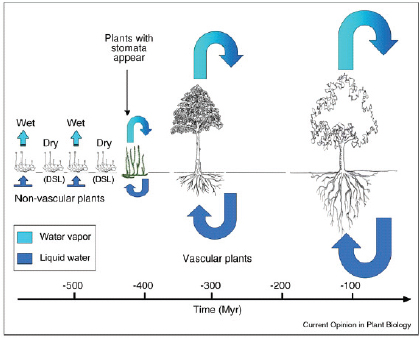
FIGURE 3-1 The evolution of roots, vascular tissue, and stomata through the Devonian Period permitted plants to gain access to water stored deeper in the soil and to transfer it into the atmosphere. This increase in transpiration generated increases in precipitation over continents, significantly influencing the water cycle and climate processes. SOURCE: Reprinted, with permission, from Berry et al. (2010). © 2010 by Elsevier.
about a dominance of subsurface flow to river channels for much of the global runoff that reaches channels. Erosion processes and rates also must have changed, altering landscape evolution. All current landscapes and ecosystems emerged under this new, biologically mediated hydrologic system. More focused research is needed to understand how the hydrologic feedbacks between organisms and the physical environment shape the co-evolution of landscapes, and the extent to which vegetation controls hydrology at local and regional scales.
3.2. The Hydrology of Terrestrial Ecosystems
Hydrology plays a critical role in driving the environmental patterns that exist and evolve on Earth.
Dominant vegetation type or biomes, standing biomass, and annual primary production (energy fixation from sunlight by plants) vary with mean annual precipitation. Within biomes, inter- and intra-annual variation in the timing and amount of precipitation can exert strong control on primary productivity and vegetation structure. In systems where vegetation growth is strongly water limited, small changes in the magnitude and timing of precipitation can lead to dramatic changes in vegetation composition and productivity. These interactions are less obvious, but no less important, in more humid, nutrient-limited ecosystems, where the amount, timing, and routing of water supply can substantially affect nutrient availability and soil carbon storage.
Across the full gradient of annual precipitation, the key link between the biosphere and the hydrosphere is soil moisture. Soil moisture fuels bare-earth evaporation and plant transpiration. Yet, evapotranspiration and soil moisture dynamics are the two primary unknowns in water budgets of landscapes. Soil moisture dynamics drive soil respiration (the flux of carbon dioxide, CO2, from the soil to the atmosphere) and are a significant contributor to the global CO2 budget, but soil moisture has proven extremely difficult to predict. Climate models that find agreement in predicting future temperatures and rainfall may nonetheless generate widely different predictions of soil moisture. Reducing this critical uncertainty in understanding the mechanisms of feedbacks between vegetation and climate is central to the ability to effectively predict future climate and vegetation dynamics at local and global scales.
Among the barriers to building meaningful predictions of soil moisture are the challenges to linking small-scale transport processes in plants and soils with local atmospheric processes. In a review article, Katul et al. (2007) suggest that two primary barriers limit the progress of soil-plant-atmosphere interactions mediated primarily by hydrologic fluxes. First, scientists have limited ability to describe water movement at the very smallest scales where fine plant roots interact with soil water, where small tubes (xylem) carry water in plants, and where water diffuses through plant tissue. Second, once scientists achieve appropriate microscopic descriptions, the appropriate methods to extrapolate them to larger spatial scales and longer time scales are lacking (what is known in the field as an “upscaling” problem). Understanding how water molecules move through soils and plant tissues and developing the scaling laws necessary for extrapolating this understanding to ecosystem scales is a challenge.
Hydrologists have made significant progress in understanding how vegetation responds to and controls local and regional hydrology in arid and semi-arid climates, where water limitation is a major determinant of vegetation patterns. Here competition for limited water leads to spatially structured vegetation, which may simply trace the topographic controls on water paths. Alternatively, plants themselves may create spatially variable conditions favorable to their survival by influencing soil characteristics that alter surface water infiltration, moisture retention, and erosion. Much remains to be discovered about controls on pattern and process.
Hydrologists, ecologists, and geomorphologists have found common cause in studying the water mediated interactions among climate, vegetation, and landscapes within terrestrial ecosystems. These ecosystems include the entire food web of animal life they support, but the dependency of animals on precipitation is often indirect and tied to precipitation variability and seasonality. In water-limited landscapes, correlations between ungulate populations (for example) and rainfall have been found, but even here density-dependent interactions, such as competition for food, may obscure simple climate dependencies (Owen-Smith, 2006). Understanding how the loss of native species or the addition of invasive species to ecosystems may alter vegetation and climate is equally important as understanding how changing climates may affect terrestrial organisms.
How do soil and rock moisture vary across landscapes and in turn drive biotic, geochemical, erosional, and climatic processes?
Water in unsaturated soils, typically referred to as soil moisture, is returned to the atmosphere through bare soil evaporation and plant transpiration. This evapotranspiration is approximately 57 percent of the total land precipitation (Van der Ent et al., 2010), and it uses up about 50 percent of the total solar energy absorbed by the land surface (e.g., Seneviratne et al., 2010). Soil moisture influences climate as a source of moisture, and in various ways it influences latent and sensible heat fluxes. Soil moisture influences water potential gradients (and thus infiltration rates and unsaturated subsurface flow rates), thereby influencing runoff paths and the resulting erosion during storms. Geochemical reactions are partially paced by water content and associated microbial activity. Soil moisture controls and is regulated by vegetation; hence, understanding moisture dynamics is central to related studies. Soil respiration varies with seasonal moisture in the soil. Despite the central role that soil moisture plays in Earth surface processes and ecosystems, the spatial and temporal dynamics of soil moisture are poorly documented, and theory predictions have had limited success.
Hydrologists have played a leading role in mapping soil moisture and developing theory about its distribution across landscapes. Remote sens-
ing technology for mapping moisture dynamics, while providing valuable observations, only penetrates a few centimeters into the ground. Therefore, field observations and theory remain essential to obtaining estimates of soil moisture patterns and dynamics. Ground-based technology for mapping soil moisture to significant depths is advancing and will be important in creating field data sets to test remote sensing and model-based predictions of soil moisture dynamics. For example, naturally produced neutrons and their thermalization are utilized in the Cosmic Soil Moisture Observing System1 (COSMOS) to provide larger footprint measures of soil moisture (Zreda et al., 2008). Distributed temperature sensing (DTS), in which optical fibers are “planted” across agricultural fields at varying depths, is now providing soil moisture estimates using either the natural diurnal heat flux within the shallow soils, or by actively heating the cable over its entire length to form an enormous heat dissipation sensor. New approaches for assessing both the spatial and depth distribution of soil moisture are beginning to fill the gap between point sensors and remote sensing, yet this major data gap remains. Climate models are beginning to reach a resolution where the topographic effects on moisture redistribution can be treated. Large differences remain in how such models treat the water holding capacity of soils and how soil moisture regulates evapotranspiration. What are the effects of topography, geology, and land history on soil moisture patterns and dynamics?
Field studies of rooting depth of vegetation, direct observation of water transport in roots, and results from climate modeling all point to the importance of deep water sources (several meters below the ground surface). Sufficiently deep roots can lift deeper water to near surface soils, increasing moisture availability to shallow roots. In some places, soils are thick and can provide this deep water, but in others, especially places underlain by bedrock, the moisture available to plants may reside in the underlying fractured rock. In seasonally dry, hilly landscapes with thin soils, vegetation may be sustained by moisture extracted from weathered bedrock beneath the soil. The importance of this so-called “rock moisture,” and the groundwater that lies beneath it, in providing water to vegetation is relatively unexplored.
To improve hydrologic, climate, geochemical, and ecological models, field observations and theory are needed to explain and predict the spatial variation in the thickness and properties of the soil mantle and the underlying conductivity of weathered rock across landscapes. Climate models rely on compilations of soil thickness and texture properties extracted from soil surveys, but as the finer-scale topography of hills and valleys enter into climate models, soil data spatially mapped onto this topography will
____________
be needed. Very little is known quantitatively about this mostly invisible mantle, especially with regard to the spatial variation in depth of weathering of bedrock across landscapes. Although soil maps can provide guidance to estimating soil properties, there are no comparable data to estimate the depth of weathered rock that may serve as a moisture reservoir. Recently the zone from the canopy top through the soil and down into the underlying weathered bedrock and groundwater has been referred to as the “Critical Zone” (Box 3-1). Six Critical Zone Observatory field projects are currently
BOX 3-1
Critical Zone Observatories
In 2001 the National Research Council report Basic Research Opportunities in Earth Science (NRC, 2001) proposed the term Critical Zone to describe “the heterogeneous, near-surface environment in which complex interactions involving rock, soil, water, air, and living organisms regulate the natural habitat and determine the availability of life-sustaining resources.” The report recommended “integrative studies” of the Critical Zone as one of six “important problem areas spanning a wide range of future activity in Earth science.” This challenge was embraced by the research community, and by 2007 the National Science Foundation (NSF) funded three Critical Zone Observatories (CZOs) for an initial 5-year investigation and subsequently added three more in 2009. This effort has inspired a corresponding program in Europe referred to as SoilTrEC (Soil Transformation in European Catchments)a and rapidly expanding international collaborations across the globe.
The CZOs are envisioned as field environmental laboratories to explore the chemical, physical, and biological processes that shape Earth. The three main goals are (1) to develop a unifying theoretical framework of Critical Zone evolution that integrates new understanding of coupled hydrological, geochemical, geomorphological, and biological processes; (2) to develop coupled systems models to predict how the Critical Zone is driven by anthropogenic effects, climate, and tectonics; and (3) to develop an integrated data-measurement framework to document processes and test hypotheses.b
The six established CZOs are located in (1) the Southern Sierra (California), (2) the Jemez River and SantaCatalina Mountains (New Mexico and Arizona), (3) Boulder Creek (Colorado), (4) the Susquehanna Shale Hills (Pennsylvania), (5) the Christina River basin (Delaware and Pennsylvania), and (6) the Luquillo Mountains (Puerto Rico). Each of these CZOs is managed by different multidisciplinary teams, and the mix of sites offers opportunities to explore different aspects of the Critical Zone. These CZOs form a national network and meet, coordinate, and collaborate as a shared program.
____________
a See http://www.soiltrec.eu/.
funded by the National Science Foundation (NSF) across the United States, wherein hydrologic processes and development of the soil and weathered bedrock zone are studied intensively in conjunction with biogeochemical and geomorphic processes. How can results of local mechanistic studies of soil and weathered bedrock be upscaled to watershed hydrologic and regional climate models?
How have vegetation assemblages, landscapes, climate, and the hydrologic systems that drive them co-evolved?
We live on a patterned Earth. Across the planet, vegetation is banded into distinct bioclimatic zones of differing dominant vegetation. Within a zone, topography and geology can drive moisture, slope stability, and soil and mineralogical differences that structures vegetation assemblages. Systematic differences emerge with respect to orientation of hills (i.e., aspect), with, for example, more forested, moisture-demanding vegetation facing north in northern latitudes (Figure 3-2). The visible co-organization of vegetation and topography, in which topographically structured moisture availability drives dominant vegetation assemblages (most prominent in water-limited environments), has attracted many researchers. These patterns are being examined at least three ways: (1) how vegetation patterns are driven by water stress, (2) how vegetation patterns may be used to document water availability and transpiration, and (3) how vegetation patterns may, in turn, affect hydrologic and erosional processes, thereby altering soil and topographic evolution.
Highly structured vegetation patterns also occur that do not correspond to strong topographic and soil control but, instead, are argued to be emergent features that arise from competing effects of facilitative and competitive processes within the vegetation community. In some cases remarkable vegetation patterns of repeating bands, spots, and mosaics develop. In water-limited environments where overland flow occurs, vegetation clustering can have such facilitative effects as inducing water infiltration, trapping nutrients, providing shade, and protecting against herbivory. A considerable body of theory has been advanced to predict these self-organized emergent vegetation patterns. The challenge is to provide definitive tests of the theory. The vegetation patterns themselves—without extensive field work to confirm driving mechanisms—may reveal very little about their origin and therefore provide an insufficient test of theories.
A frontier area of research is to expand these inquiries into humid regions where spatially structured water availability is less apparent, but vegetation patterns still form (Rodriguez-Iturbe et al., 2007). Fire pattern and history may strongly dictate vegetation patterns in both arid and humid landscapes, either emphasizing or obscuring water availability differences
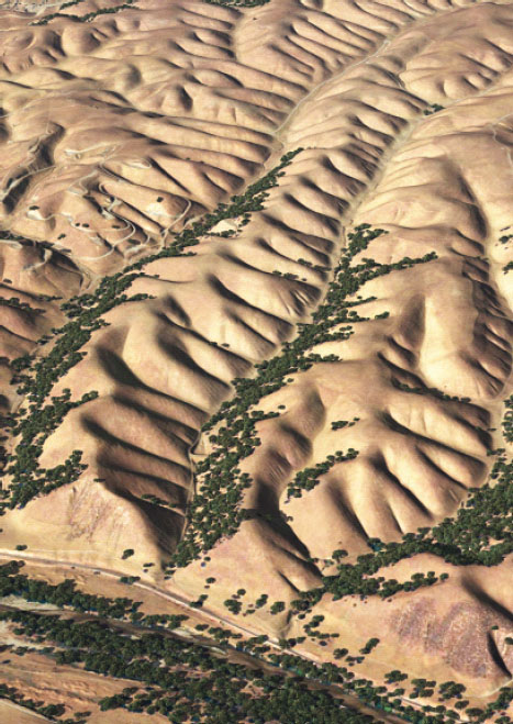
FIGURE 3-2 Digital image of the Gabilan mesa area, south of San Francisco, California, showing the strong aspect control on forest distribution. Image is derived from airborne laser swath mapping data collected by the National Center for Airborne Laser Mapping (NCALM) and then colorized and shaded to reveal patterns of vegetation and topography. The distance between each valley is approximately 160 m. SOURCE: Reprinted, with permission, from Ionut Iordache, NCALM, and Whipple (2009). © 2009 by Nature Publishing Group.
and other disturbances (e.g., extreme storms, grazing, insect outbreaks, and invading species) can take significant roles. The inclusion of multispecies, food-web, and disturbance-driven processes in coupled models of climate, hydrologic, and vegetation pattern development is an area of expanding and exciting research. What are the hydroecological interactions that reinforce the spatial patterns across diverse landscapes and varying hydroclimate regimes?
All landscapes and their ecosystems have experienced climate change. Some systems may currently be legacies of a previous climate state under which they became established and now exist with limited resilience to further change. Ecosystems, hydrologic processes, and regional climate can co-evolve to create a self-sustaining system, but one that if disturbed may not recover. Perhaps the most important such system on Earth is the Amazon rainforest. A significant fraction of all terrestrial evaporation (and transpiration) is returned as precipitation over land (e.g., Van der Ent et al., 2010). Some argue that wholesale cutting of the forest or the effects of global warming could disrupt the self-sustaining hydrologic cycle of the Amazon, leading to widespread soil drying and a shift from mesic (having a moderate supply of water) forests to drier grasslands. Scientists need to understand how modern hydrosphere-biosphere feedbacks, like those in the Amazon, have evolved to maintain current vegetation patterns in order to anticipate future states. How will vegetation communities and their regional climate co-evolve with climate variability and change?
Landscapes evolve as channels erode down, steepening adjacent hillslopes, which, through this connection, may eventually develop a form that erodes at a rate similar to that of the channel. The competition of advective processes driven by runoff (which tend to predominate in channels) and diffusive processes (which tend to predominate on hillslopes) can lead to a regular ridge-and-valley topography with distinct wavelengths (Figure 3-2). Nearly all landscapes evolve under a biota mantle, yet explicit accounting for the effects of vegetation (or the assemblages of biota in the soil) in geomorphic models is just beginning. Do topography, vegetation (and their animal ecosystems), and the hydrologic processes that connect them co-organize over geomorphic time scales?
How can scientists predict abrupt change in terrestrial ecosystems?
Of great concern is the possibility that future state changes may be irreversible, and that the approach to state changes will be nonlinear or abrupt and thus very difficult to predict. The tight feedbacks between vegetation and climate set the stage for the potential for rapid transitions in vegetation dynamics. As global and regional climate changes, vegetation will both respond to and affect the climatic regime. Global climate models predict
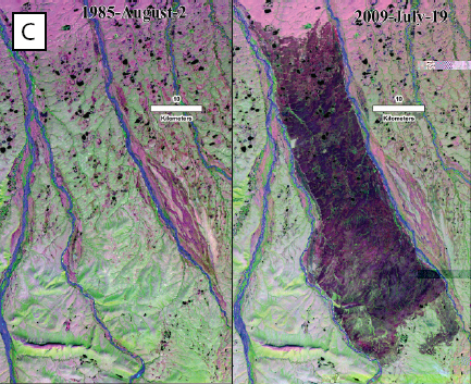
increased interannual variability in precipitation and more frequent extreme droughts, which may lead to dramatic changes in vegetation structure and productivity. The sustained drought that began at the turn of the millennium in Australia (“the millennial drought”) is estimated to be the worst drought in the region in the past century (Nicholls, 2004) and has led to soil salinization and salinity induced tree mortality (Figure 3-3A). Recent droughts in the southeastern United States and warm summers in Alaska have dried out coastal plain and boreal peatlands, increasing their susceptibility to lightning-caused fires (Figure 3-3B). In 2009, an unprecedented peat fire in the Arctic released enough carbon to offset the annual carbon sequestration potential of the entire Arctic tundra biome (Figure 3-3C).
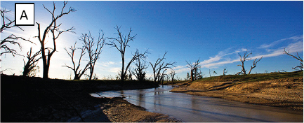
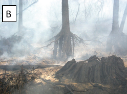
FIGURE 3-3 (A) The skeletons of red gum trees line the shrinking shores of Lake Pamamaroo in New South Wales. SOURCE: Reprinted, with permission, from J. Carl Ganter, Circle of Blue. (B) Smoldering peat in the 2008 fire in Pocosin Lakes National Wildlife Refuge, North Carolina in which 40,704 acres of peatlands burned over 6 months. SOURCE: USFWS (2009). Available online at http://www.fws.gov/fire/news/nc/evans_road.shtml
Conversely, changes in vegetation can strongly influence local climate, and particularly large scale changes when land cover can influence regional climate. Afforestation efforts can lead to dramatic reductions in streamflows, which may be proportionally more important in arid regions (e.g., Farley et al., 2005). Significant forest regrowth in the eastern United States has led to reduced midsummer temperatures in some areas. Conversion of native vegetation to croplands typically increases evapotranspiration rates and enhances cooling. Biological soil crusts, composed of soil particles and various microorganisms including cyanobacteria, green algae, and bacteria, are estimated to be the dominant ground cover in some arid lands. Destruction of these crusts through land management practices, especially grazing,
[accessed August 6, 2012]. (C) Landsat TM image of a large peat fire in the Arctic in 2009, pre and post scar. It is estimated that this fire released 2.1 Tg of carbon to the atmosphere. SOURCE: Reprinted, with permission, from Mack et al. (2011). © 2011 by Nature Publishing Group.
can lead to changes in runoff and increased erosion (including contributing to atmospheric dust loads). Land cover change can therefore strongly influence local and regional hydroclimatology. Incorporating the potential for abrupt changes in vegetation climate feedbacks into future climate modeling scenarios is an important research challenge.
3.3. Subsurface Ecosystems and Hydrologic Processes
Subsurface ecosystems create and direct hydrologic pathways, release gases to the atmosphere, and control access to moisture and nutrients by aboveground ecosystems.
Although largely invisible, subsurface ecosystems play a central role in hydrologic, climate, and aboveground ecologic processes. Soil formation is not only driven by the action of water movement and freeze thaw action, but also by biotic activity, from burrowing by worms, insects, and animals to geochemical processing by pervasive and extremely diverse microbial organisms. Soils, to a large degree, are a biofilm mixed with inorganic rocks and minerals that provide a key membrane on Earth’s surface. Fauna and flora extend deeper into weathered bedrock, but here geochemical influences are more significant than mechanical disturbance by biota. Subsurface ecosystems, although concentrated near the surface where there are nutrients and high moisture levels, run deep.
Research has focused on the coupling of aboveground and belowground ecosystems. Roots make a direct connection between the two domains, and, despite considerable work, chemical, physical, and ecological processes associated with root interaction with the soil and the uptake of nutrients and water are still relatively poorly known. The flux of CO2 from decomposition (respiration) is estimated to be more than 25 percent of the global CO2 budget (Houghton, 2007). The flux comes from respiration by live roots, respiration from root symbionts exploiting root-derived carbon, and soil fauna respiration in consumption of soil organic matter. The relative importance of these processes is not well known, yet it matters in anticipating how CO2 budgets will change under future climate states. Soil moisture influences subsurface biotic activity and thus the CO2 flux. Water-driven subsurface ecosystem dynamics matter to global-scale processes.
Subsurface life—bacteria, fungi, and vascular plants—are affected by and also strongly influence hydrologic pathways and properties. Infiltration rate, hydraulic conductivity, and moisture retention properties all depend to some extent on biotic activity. Bacteria change the fabric of soils through their metabolic activities. Fungi, plant roots, and burrowing worms alter soil structure, thereby changing its hydraulic properties. Plants in arid regions
establish in patches that alter sediment accumulation and water infiltration. Strong and important feedback mechanisms link hydrologic science, soil science, and ecology. Models that explicitly account for biotic activity will allow for better predictions of soil evolution and expansion of the understanding of related hydrologic and biologic interactions in the subsurface.
How are subsurface biota controlled by and influencing hydrologic processes?
The estimates vary, but there is general agreement that more life is below Earth’s surface than above it. The diversity is staggering: just a few grams of soil could contain more than 1012 bacteria, representing more than 1,000 species, hundreds of species of invertebrates (Wardle et al., 2006), and 25 km of fungal hyphae (Hinsinger et al., 2009). Soil animals may constitute more than 20 percent of the total diversity of living organisms presently described (Lavelle et al., 2006) and represent 50 percent of the total animal biomass on Earth (Fierer et al., 2009). Despite this abundance, soil biota are extremely heterogeneous and patchy in occurrence, and for many biota the soil is a nutrient and moisture desert occasionally swept by storms of infiltrating water. These biota make their own world.
Ecologists are exploring what causes such diversity, what distinguishes functional groups and their relationship to environments, and how to map and explain the diversity in the few grams of soil to that found in entire landscapes. In the shallow region of the soil, the two biotic worlds are linked: plant production feeds soil organisms, while decomposition of plant waste in the soil by these organisms provides nutrients to plants. This linkage is much richer, however, than just production and decomposition (Figure 3-4) and has led to considerable research on the above- and belowground interactions. Soil organisms also may be differentiated by the presence of water: fungi, some nematodes, and arthropods live in air-filled pores, whereas bacteria, protozoa, and other nematodes live in water-filled pore spaces and water films.
The connection of water and life is perhaps most strongly expressed in the rhizosphere (i.e., the volume of soil surrounding a living root). In this small volume, plant life, and all that depends on plants, is sustained. The biogeochemistry, biophysics, and ecological processes in the rhizosphere are still relatively poorly known, but it is clear that water content and distribution play a central role. Just the simple selection process in which some plants can grow and maintain roots in drying soil while others cannot may determine vegetation community composition (as well as agricultural practices). Plants not only extract moisture but also, via hydraulic lift in which water from deeper roots is brought up and discharged out of roots into shallow soils, may add moisture (during nighttime favorable potential
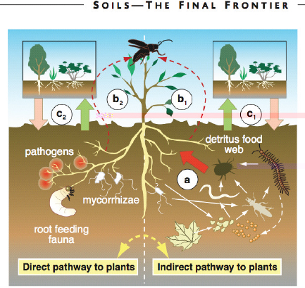
FIGURE 3-4 An illustration of the linkages between aboveground communities and communities in the shallow region of the soil. From Wardle et al. (2004): “(Right) Feeding activities in the detritus food web (slender white arrows) stimulate nutrient turnover (thick red arrow), plant nutrient acquisition (a), and plant performance and thereby indirectly influence aboveground herbivores (red broken arrow) (b1). (Left) Soil biota exert direct effects on plants by feeding on roots and forming antagonistic or mutualistic relationships with their host plants. Such direct interactions with plants influence not just the performance of the host plants themselves, but also that of the herbivores (b2) and potentially their predators. Further, the soil food web can control the successional development of plant communities both directly (c2) and indirectly (c1), and these plant community changes can in turn influence soil biota.” SOURCE: Reprinted, with permission, from Wardle et al. (2004). © 2004 by The American Association for the Advancement of Science.
gradients). This effect has been shown to have consequences not just for moisture availability to plants. The hydraulic conductivity of soils depends strongly on soil moisture; therefore fluxes of water into and out of the soil can be affected by hydraulic lift. In addition, because transpiration exports the lifted water to the atmosphere, there may be a significant influence on regional humidity, temperature, and thus climate even on the scale of the Amazon basin. Hydrologic processes connect relatively deep groundwater, as well as the rhizosphere, to the atmosphere.
Soil developed on sediment deposited by rivers (most obviously on Earth’s the great lowland floodplains) causes material properties to change significantly from the original source material. But this change is not surprising compared to the drastic alteration that occurs in the transformation of bedrock to soil. Bedrock, strong enough to be cut into slabs and used in buildings, can, over time, be reduced to an assemblage of loose soil particles bearing no physical resemblance and limited chemical similarity to the parent material. Often this soil is essentially the digested residue of life. In many environments it is the persistent burrowing, chewing, and dissolving by biota that destroy the rock structure and produce a loosened soil. Soil biota transform dense rock into a permeable, moisture holding, chemically diverse environment, through which infiltrating waters pass and chemically evolve. Earthworms are especially important, and the invasion of exotic earthworms in North America has changed nutrient dynamics and soil structure, leading to changes in plant community composition (i.e., Boyer and Wratten, 2010). Elsewhere, ant and termite colonies can be especially important in creating patchy disturbance. Bioturbated soil in general is extremely heterogeneous, with areas of tightly held water that may remain well beyond a rainy season, and pathways of rapid preferential flow established by soil fauna and roots. Such differential retention would contribute to the age distribution function of water entering channels. Roots can also be pathways for rapid injection of incoming soil water to considerable depth (hydraulic redistribution). To model watershed dynamics, hydrologic scientists often use “pedotransfer functions.”2 Biota’s influence on soil characteristics is not captured solely by the soil texture they helped create. How can the effects of soil biota on the hydraulic properties of soils be quantified?
Hydrologists have a central role in developing an understanding of Earth’s carbon cycle, and for soils, which are estimated to contain 80 percent of the planet’s terrestrial carbon, this is especially true (Nielsen et al., 2011). Models are exploring and field experiments are examining vegetation
____________
2 A pedotransfer function is a relationship that allows estimation of soil hydraulic properties (water retention and hydraulic conductivity) from soil characteristics such as texture (sand, silt, and clay content).
responses to anticipated increased CO2, which may include CO2-induced stomata closure, increased moisture content, and increased leaf area index. Soil organisms play a primary role in organic matter decomposition, but temperature and moisture content mediate soil biota and may be affected either directly by changes in climate or indirectly by CO2-mediated changes in plant water use efficiency and evapotranspiration. The interdependence among CO2, soil moisture, plant growth, and transpiration may have contributed to controlling the range of CO2 over geologic time scales. Coupled soil moisture, soil biota, and vegetation assemblage studies are needed to explore the role of belowground organisms in influencing theses outcomes.
Subsurface ecosystems and the interdependence between vegetation and belowground biota are a frontier area of research in which water abundance, seasonality, and spatial distribution play a first-order role. Should models directed at the coupled evolution of vegetation assemblages, topography, and local climate account for the equally evolving soil biota and their influence on hydrologic and biogeochemical properties? How do organisms in soil and weathered bedrock influence solute chemistry of runoff? Can the effects of soil organisms on hydraulic properties and the resulting age distribution of water and preferential pathways be predicted?
3.4. Critical Links in Aquatic Ecosystems
Hydrologic flow regimes, river channel dynamics, and aquatic ecosystems are linked, resulting in a co-evolution of rivers and river ecosystems.
The statement “rivers are the authors of their own geometry” (Leopold and Langbein, 1962) captures the central idea that, simply through the interaction of water flow and sediment transport, natural rivers create highly regular, self-contained channels. Rivers, for example, can migrate across their floodplains, leaving meander cutoff loops, and do so for thousands of years and yet show no significant change in average channel width. Internal scaling within river systems is so strongly developed that it is not possible without a scale bar to tell the size of a river from a map of channel platform. This dynamic regularity (rivers are rarely fixed in place) creates repeated, heterogeneous environments to which aquatic ecosystems are finely tuned.
Efforts to reproduce this regularity in laboratory channels have met with great success when flume walls are fixed and water discharge and sediment supply are held constant. Laboratory experiments with erodible banks, however, have had little success, and only recently have lateral migrating channels with cutoffs been created experimentally. For such channels to develop, some bank strength beyond that created by frictional
resistance of sand and gravel is needed. One important source of strength is vegetation. Hence, riparian vegetation is not simply following river courses; rather it is strongly influencing the course, form, width, and dynamics of rivers. Vegetation invades exposed bars during seasonally low flow and stabilizes them against subsequent change. Fallen trees create local complex environments where they partially block river flow, and prior to land use management, large jams of fallen trees would form and redirect even fairly large rivers. Similarly beavers (genus Castor) in North America and Europe once converted smaller streams into chains of lakes, and modified the form and path of larger ones. River morphodynamics and river ecosystems are interacting and interdependent. The relative strength and importance of these interactions depend on flow and sediment regimes and river size. Considerable theoretical progress has been made in the prediction of channel flow, sediment transport, and bed morphology for fixed channel width in the absence of strong biotic influences. Needed are field observations and theory that explicitly link river morphodynamics with aquatic and/or riparian ecosystems. Research has begun, driven by not only the search for answers to the fundamental questions, but also the goal of guiding river restoration and redesign.
Human-induced changes in flow regimes alter not only the spatial extent and quality of freshwater habitats but also the connectivity between freshwater ecosystems. As habitat quality and quantity decline and freshwater systems increasingly fragment, aquatic and floodplain species are being lost and the water quality of the world’s rivers and coastal zones is being degraded. A central challenge for the hydrologic and ecological community is to find common ground in understanding the complex ways that flow regimes impact critical geomorphic and ecological processes and in turn the maintenance and dispersal of organisms in aquatic ecosystems.
What are the critical components of river hydrologic regimes that dictate composition and dynamics of aquatic ecosystems?
The great physical diversity of river and floodplain habitats is critical to the evolution and maintenance of freshwater biodiversity. The form, dynamics, and resulting interactive ecosystems of river channels are driven by flow characteristics, sediment load (and size), bank resistance, confinement, and channel slope. The morphodynamics of rivers systematically changes downstream as they drain larger watersheds, carry more water and sediment, and become less steep. Rivers create a network of numerous small channels feeding larger ones that generate repeated habitats across the landscapes and different but linked habitats (e.g., where small channels enter large ones). Coarse-bedded steep upland rivers are confined in canyons and experience localized shifts where tributaries enter. As valleys widen down-
stream, rivers will sweep and shift laterally and flood periodically, creating seasonal habitats that may be vastly more productive than in-channel environments. Biota influence channel morphology through controlling bank strength (e.g., rooted vegetation), trapping fine sediment, and redirecting flow and sediment (e.g., through fallen wood and beaver dams). Hence, there is a co-evolution of rivers and river ecosystems. This co-evolution can be disrupted either by changes in external drivers (e.g., climate and tectonics) or by changes in internal interactions (e.g., sediment pulses, vegetation dynamics, or the introduction of non-native species, Figure 3-5).
In addition to its role in shaping a river system’s physical habitat, the flow regime is itself an important determinant of the distribution, abundance, and life history traits of river and floodplain (riverine) organisms within its basin. Flow magnitude, frequency, timing, duration, rate of change, and predictability of flow events (e.g., floods and droughts) act
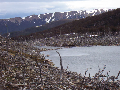
FIGURE 3-5 The introduction of the beaver Castor canadensis to Tierra del Fuego, an archipelago off the southernmost tip of South America, created extensive damming of streams and converted nearly 30-40 percent of the island’s riparian Nothofagus (or southern beech) forests to floodplain wetlands (Anderson et al., 2009). SOURCE: Photo courtesy of Christopher B. Anderson, University of North Texas.
both individually and collectively as constraints on population growth or determinants of successful life history traits. Many aquatic organisms synchronize their life-cycle events to the occurrence of flow regime events. For example, many aquatic insects time their emergence to avoid annual bottlenecks of peak flows or droughts, and many fish time their migrations through river networks to minimize the risk of being stranded in disconnected habitats. Many fish depend on the seasonal inundation of floodplains of lowland rivers for food and reproduction, in tropical (Junk, 1984) and temperate (Gorski et al., 2010) river systems. A wide variety of terrestrial organisms may tune their distribution and behavior to these river patterns, with organisms as diverse as humans, bears, bats, lizards, spiders, and riparian plants relying on peaks in insect emergence or fish spawning to supply a substantial portion of their annual energy or nutrient demands.
Flow regimes are being affected by land use disturbance (especially dams, water withdrawal, and channelization) and climate change. As flow regimes change, the winning evolutionary strategies of the past may prove less competitive so that native species may be lost and new species may become dominant or invade aquatic ecosystems from which they were previously excluded. Although it is clear that water resource management that is more sophisticated than merely protecting minimum flows is necessary, a central challenge for understanding the modern distribution of riverine organisms (and the terrestrial organisms that rely upon them) is to determine which aspects of the hydrograph are most closely associated with the protection, maintenance, and restoration of biological communities and ecosystem processes.
Many questions remain. How do river food web networks depend on river networks? What components of a river’s hydrologic regime are essential to channel morphodynamics and river ecosystems? What is a necessary amount of sediment supply (and size of sediment) to maintain or rebuild river ecosystems? How will changes in flood frequency regimes or extended periods of drought flow (associated with climate change or land use) alter channel (and floodplain) habitat?
3.5. Hydroecosystems in Transition
Earth’s ecosystems are in a state of transition as a result of climate change and changing land use.
The term ecosystem refers to “any area of nature that includes living organisms and nonliving substances interacting to produce an exchange of materials between the living and nonliving parts” (Odum, 1959). An ecosystem generally encompasses a region of relatively homogeneous biological
composition and is distinguished from other regions by markedly different composition. For example, scientists would recognize a forest ecosystem as separate and different from a grassland ecosystem. Of course, where forest meets grassland, there is a transition zone, often called an ecotone. Organisms are conditioned to a certain range of conditions in the physical environment, and changes in the physical environment can lead to transitions in ecosystems. If air temperatures rise in the Arctic, for example, the tree line may move poleward and potentially displace tundra ecosystems completely. Ecosystem transitions are known to have profoundly impacted humans in the past and can be expected to be impactful in future. The processes that determine transitions in ecosystems are not well characterized or understood. Two examples of hydroecosystems in transition and related research are discussed below.
How will the sensitive extremes of Earth’s hydroecosystem, that is, the cold regions and warm deserts, respond to climate change and land use change?
Climate change has sparked a great expansion of research in cold regions (including the polar regions and high mountains) to document, explain, and predict changes that inevitably will come. In part because of recent major reports, for example, the Arctic Climate Impact Assessment (ACIA, 2005) and the Intergovernmental Panel on Climate Change (IPCC, 2007), observations and concerns about these cold-region systems have gained wide attention. Much has been written about glacier retreat and instability. Although glaciated landscapes are important, a large region on Earth is not currently covered with glaciers but experiences cold climate. Changes to this region caused by climate change will feed back to climate evolution itself. These regions include the 80 percent of Alaska and 22 percent of the Northern Hemisphere that is affected by frozen ground (permafrost).
Some expected changes have already been detected, while others have not. A complex weave of positive and negative feedbacks, but mostly positive (self-reinforcing), arise from many sources, including snow depth change, streamflow variation, stability of permafrost, forest expansion into tundra, deciduous tree expansion, albedo reduction, carbon and methane release, fires, increased transpiration, and changes in surrounding sea-ice cover. Research should delve into this complexity to enhance the ability to predict the rate, magnitude, and nature of change and sort out the sign and intensity of various feedbacks. Changes in the depth and patchiness of permafrost can change terrestrial water storage and flow paths, thus influencing biogeochemical processes and vegetation features such as albedo, and susceptibility to insect destruction and fire. Hence, understanding changes
in hydrologic processes is central to understanding how vegetation and climate may co-evolve.
Thawing of the permafrost also may profoundly affect erosional processes. Landslide may become more frequent and widespread where liquid water forces elevated pore pressures. Melting water may lead to gully formation and potentially widespread increase in sediment production. Ice strengthens river banks and may play a central role in controlling channel morphodynamics; permafrost melting will change the rate of river shifting in meanders and the perseverance of meandering over braided forms. Similarly, melting permafrost may increase coastal zone erosion, releasing sediment and organic matter. These geomorphic transitions may in turn influence greenhouse-gas release, nutrient supply to food webs, river navigation, and infrastructure (e.g., pipelines, roads, and housing). For example, a significant amount of the world’s carbon is stored in frozen Arctic soil (Oechel et al., 1993). If rising temperatures cause the permafrost to melt and the organic matter contained therein to be broken down by bacteria, huge amounts of greenhouse gases will be released (Schiermeier, 2001).
Global climate models forecast expansion of Earth’s warm desert regions, but the rate of change will depend on various feedbacks associated with shifting vegetation that alter albedo, evapotranspiration, and surface roughness. Studies have focused on how decreased water availability and elevated temperature will change the composition and structure of vegetation communities (including the invasion of exotic plant species), which will in turn affect the entire ecosystem and the regional climate. Other effects, including vegetation response to increased CO2, nitrogen deposition due to pollution, and changes in fire frequency (mediated in part by grazing), add uncertainty about the pace and magnitude of landscape change. Reduced vegetation cover will increase dust, which will have direct effects on climate and hydrologic processes (dust deposition on alpine glaciers leads to accelerated melting). Model results also point to reduction in streamflow and loss of critical water supplies to both humans and ecosystems. Predictions about the future of deserts will depend on new research that explores and explains these ecological, hydrologic, and climatic interactions. How will land cover change and water extraction exacerbate or alleviate desertification trends? How will physical and biological responses to desertification in turn alter local and regional climate?
What controls the low flow extent of stream networks?
Low flow in rivers can be defined by the extent of continuous (perennial) flow and by the magnitude of that flow (relative to channel size). River organisms at low flow are confined to narrow strips of water emanating from upland sources. The uppermost tip of the permanent stream network
defines the reach of perennial flow and is, therefore, a major ecological boundary. The extent of the stream network also strongly influences stream temperature. Upstream of the perennial flow, seasonally isolated pools may form, or the stream may become completely dry (periods of zero flow). Of course, the smaller the drainage area, the more likely this critical transition will be crossed, but relatively large channels can also go dry where flows are insufficient. This regularly happens in arid landscapes and during extreme dry periods in more humid landscapes, but also where water diversions, sometimes by streamside groundwater pumping, reduce surface flow.
The perennial streams that show up as “blue lines” on official U.S. Geological Survey maps are typically based on inference rather than direct observation of flowing water. Some empirical studies have used multivariate analyses between physical features (drainage area, slope, and so on) and observed perennial, ephemeral, and intermittent streams to estimate the perennial flow channels, but such approaches have no ability to anticipate how the extent of such channels may change under varying land use and climate. Climate change will change the nature of river flows in the world (e.g., Milly et al., 2005). The consequences for aquatic ecosystems have received little study and essentially no systematic observations of or theory exist to predict the full spatial extent of perennial flow in river networks.
An increased emphasis on these critical hydrologic bottlenecks for aquatic organisms—low and zero flow periods—is needed in order to protect the biodiversity of aquatic ecosystems. Periods of low flow are integral parts of the hydrograph for many rivers and are necessary for many processes in riverine ecosystem functioning. A number of important ecological processes center around low and zero flow periods. Yet during low flow periods habitat availability contracts and suitable freshwater habitats become fragmented, which can have negative implications for the dispersal of organisms and materials through river networks. Competition for resources is intensified, and predation risk increases when habitat and other resources become limited at low flows. Habitat quality often declines in contracting aquatic habitats (e.g., rising salinity, decreasing dissolved oxygen concentrations in contracting isolated pools of a dryland river). Under extreme drought, freshwater organisms are restricted to rare refugia, where poor water quality and intense competition may drive some species to local, regional, or global extinction.
Besides mapping the spatial extent of perennial flow through channel networks it is also important to quantify low flow discharges. (Of course, quantifying low flow hydrology is important to humans as well as to ecosystems, see Box 3-2.) In order to understand and predict ecological responses to altered flow regimes it is critical to be able to both measure and model low and zero flow hydrology. Low flow hydrology has received relatively little attention from researchers (Smakhtin, 2001) in comparison
with stormflow generation. The mechanisms of flow generation at low flows in catchments should be better understood so the impacts of land use and climate changes on aquatic organisms can be assessed. Given the need for low flow measurement and modeling to understand critical ecological responses to flow management, there is a compelling case for hydrologic scientists to work with ecologists to solve these hydroecological problems to provide the tools needed to make better ecological predictions.
What sets the spatial extent of streamflow in a given channel network, and how does this extent (and flow magnitude) vary seasonally? How will the flow network change in droughts? What will be the effect of predicted climate change on the low flow stream network? How will aquatic and riparian ecosystems respond to low flow channel network contraction and to reduced perennial flow? Are small systems more sensitive to stress from climate variability and water extraction because of an increased likelihood of crossing critical thresholds (e.g., cease to flow)?
3.6. Conservation and Restoration Hydroecology
Theory and mechanistic field studies are needed to guide the protection, redesign, and restoration of ecohydrologic functions on landscapes.
A fundamental shift has taken place in how society values natural processes and manages landscapes. Wetlands, once considered low-quality land in need of drainage, are now known to provide a wide range of critical ecosystem services, from flood control to essential habitat for commercially important species. Rivers, viewed largely as large-scale canals, were blocked from migration, cut off from their floodplains, and depleted of sediment and water. Now efforts are under way to restore natural processes to rivers and wetlands in order to regain aquatic ecosystems’ functions and flood management. Vegetation management, whether through fire control, grazing practices, agriculture, or industrial timber production, is now seen as having a dual objective of resource use and maintaining or regenerating desired ecosystem outcomes. Goals are being stated that, for example, would lead to sustainable timber production and functional ecosystems. Is it possible that better practices will benefit both resource exploitation and ecosystem function? Can natural systems and the ecosystem services they provide be made resilient to anticipated environmental change?
To answer these questions, knowledge of the coupled hydrologic processes, geomorphology, and ecology of these systems is essential. Management actions for a desired outcome, whether changing grazing practices or adding wood to streams, are based on predictions (by inference, experience,
BOX 3-2
Drought and Urban Water Supply
The recent 2-year drought in the southeastern United States (2006-2008) was dubbed one of “historic proportions,” because major metropolitan areas as well as surrounding rural communities from North Carolina to Alabama faced an emergency so serious it gained national attention (Figure 3-6). At one point, Lake Lanier, Atlanta’s main water supply, contained only 90 days of water supply. The severity of the situation fanned the flames of the debate surrounding the allocation of water from two large river systems in the southern states of Alabama, Florida, and Georgia—the Apalachicola, Chattahoochee, and Flint rivers, and the Alabama, Coosa, and Tallapoosa rivers (NRC, 2009). A centerpiece of this debate is how much water should flow from Georgia’s Lake Lanier, a reservoir critical to Atlanta’s water supply, to Florida’s Apalachicola Bay a supply that is critical to the Florida Panhandle’s oyster and fishing economy. The supply of reservoir water is also critical to ecosystems along the way to the Florida Panhandle—ecosystems that include protected species like the fat three ridge mussel and Gulf sturgeon, as well as many other species. A recent study (Seager et al., 2009) shows that this drought was climatically less severe than even the Southeastern drought that occurred in 1998-2002. When extended records of hydroclimatic variability from tree-ring data were considered, the 2006-2008 drought was found to be much shorter than numerous past droughts (Figure 3-7).

FIGURE 3-6 “CUMMING, Georgia—With water supplies rapidly shrinking during a drought of historic proportions, Governor Sonny Perdue declared a state of emergency Saturday for the northern third of the state of Georgia and asked President [George W.] Bush to declare it a major disaster area. Georgia officials warn that Lake Lanier, a 38,000-acre reservoir that supplies more than 3 million residents with water, is less than three months from depletion. Smaller reservoirs are dropping even lower.” SOURCE: Quote available at http://www.msnbc.msn.com/id/21393296/ns/weather/t/georgias-governor-declares-drought-emergency/; image: Lake Lanier Reservoir, Fall 2007. Reprinted, with permission, from Pouya Dianat, The Atlanta Journal-Constitution. Available at http://www.nytimes.com/2007/10/16/us/16drought.html.
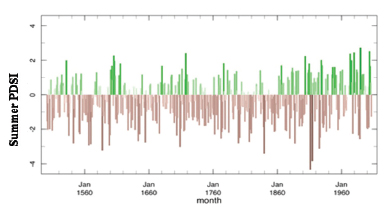
FIGURE 3-7 Summer Palmer Drought Severity Index (Summer PDSI) averaged over the Southeast United States reconstructed from tree-ring data for the period 1000-2006 A.D. PDSI is based on a water balance estimate. The larger the negative number, the more severe the moisture deficit and the stronger the drought. Note the frequent occurrence of multi-decadal drought conditions. SOURCE: Reprinted, with permission, from Seager et al. (2009). © 2009 by American Meteorological Society.
or more quantitative approaches). Currently lacking are both sufficient understanding from field studies and quantitative models to make reliable predictions about desired outcomes from management decisions in many applications.
What will make wetlands restoration work?
As an environment that transitions between land and water, wetlands are the ultimate theater for the interaction of biota and hydrologic processes. Although vaguely defined in common language, wetlands are nonetheless now commonly understood to be vital parts of Earth’s surface, playing a unique role in regulating biogeochemical cycles and providing much more than habitat for birds, fish, and other organisms. Terms such as peatlands, marsh (no trees), swamp (trees present), bog, fen, playa, vernal pool, and meadow are used to distinguish wetlands. These distinctions highlight different coupled hydrologic and ecologic systems that have emerged across the planet. But three components of these systems are often used to define them as wetlands: (1) the seasonal or permanent presence of shallow standing water or groundwater saturation, (2) soils that show the effects of seasonal or permanent saturation, and (3) vegetation adapted for this condition (which involves seasonal or permanent low oxygen levels at root level). These three attributes, in fact, are formally used in U.S. regulations to define the presence of wetlands and the necessary management of them. One common element exists: wetland ecosystems are strongly dependent on subtle changes in the duration, frequency, and magnitude of water at or above the ground surface.
Once systematically drained to prevent disease and facilitate agriculture, wetlands in the United States are now legally protected and formally recognized for the variety of “ecosystem services,” they provide which include the following:
(1) key habitat for many organisms including harvested biota;3
(2) flood mitigation by storing river floodwaters;
(3) coastal storm surge abatement through wave attenuation and flood storage;
(4) aquifer recharge;
(5) water quality improvement by retaining contaminants such as excess nutrients;
(6) timber production;
____________
3 The majority of fish and shellfish species harvested commercially in the United States are wetland-dependent in some phase of their life cycle, and perhaps two-thirds of the fish harvest depends on coastal and inland wetlands (Mitsch and Gosselink, 2000).
(7) habitat for endangered and threatened species (particularly waterfowl and fish);
(8) agriculture (e.g., native rice production, water supply, and nutrients);
(9) carbon sequestration (globally wetlands occupy approximately 6 percent of the land surface but are estimated to store more than half of global soil carbon (Reddy and DeLaune, 2008)); and
(10) energy resources (peat harvested and burned).
Many of these benefits have become apparent in the United States in recent years, whether it is through the effects of wetlands loss or the effects of Hurricane Katrina in 2005 along the Gulf Coast or the value of floodplain storage during flood events that sweep down the Mississippi River (Box 3-3). Yet, despite these values perhaps one-half of the world’s wetlands are gone, and the loss of wetlands continues. In some areas, the loss is greater, including California, where it is estimated that only 10 percent of the original wetlands remain. In the United States more than 70 percent of the remaining wetlands are on private lands (Copeland, 2010); consequently, defining wetlands and valuing their ecosystem services take on elevated significance. The concern is global, as expressed by the Ramsar Convention of 1971,4 which is the only global environmental treaty that deals with a specific ecosystem.
Wetlands are being constructed, redesigned, restored, and protected, and each of these actions calls for increased scientific understanding of wetland functions and the interconnected hydrologic, biogeochemical, and ecological processes. In response to this need, research on wetlands has exploded in the past 20 years (Zhang et al., 2010). The practice of making “constructed wetlands” has become a particularly important management technique aimed at removing contaminants from contaminated waters. Constructed wetlands are now used in agriculture, urban runoff, mining, sewage treatment, and other industrial and municipal waste treatments needs. Theory has guided construction of these wetlands, but models have tended to be a “black box” where the detailed mechanisms driving biogeochemical processes are not explicitly treated.
The challenge of wetlands protection raises many basic research questions. What flow duration and timing is necessary to protect extant wetlands? How can we manage the hydrologic regimes of natural, restored, and constructed wetlands to most effectively retain and remove contaminants or to protect species dependent upon wetland ecosystems for all or part of their lives? How do vegetation development and subtle flow dynamics lead to distinct self-organized patterns of vegetation assemblages? How will
____________
4 See http://www.ramsar.org.
BOX 3-3
Mississippi Delta Restoration
The Mississippi River Delta has lost about one-third of its original wetland since European settlement of North America. This wetland provides many ecosystem services, most notably freshwater habitat and storm surge protection. At the current rate of land loss and shoreline migration, it is estimated that New Orleans will be exposed to the open sea by 2090 (Fischetti, 2001).
The reduction of sediment supply to the delta due to dam construction in the Mississippi watershed has contributed to this land loss. But presently the main cause of land loss is the confinement of the river to levees, which have created an efficient “pipeline” of sediment (and nutrients) directly out to the Gulf of Mexico. The levees prevent the river spilling into adjacent coastal basins, where sediment deposition would provide the mineral base for wetlands vegetation growth and thus sustain the delta level. Without this resupply the coastal wetlands drown because of natural and anthropogenic (due to hydrocarbon extraction) subsidence and sea-level rise. The final result is open water with no remaining wetlands ecosystem services.
Engineered avulsions, in which river flood flow is directed into coastal basins, had been proposed, but doubts were raised about sufficient sediment supply, the high rates of subsidence, and the anticipated effects of climate change induced sea-level rise. Figure 3-8 shows an example, however, where numerical modeling performed as part of the delta dynamics integrated research project of the National Center for Earth Surface Dynamics demonstrates the possibility of land building. This model suggests that effective land building can be done without threatening navigation or demanding a large fraction of the Mississippi flood flow.
Basic research is needed to guide such a major restoration project. Recently NSF funded a “Delta Dynamics Collaboratory” that will support an intensive field observatory (the Wax Lake Delta, a recent, actively growing delta about 100 km west of the main Mississippi delta) and a modeling activities center associated with the NSF supported Community Surface Dynamics Modeling System (CSDMS) at the University of Colorado. The interaction of sediment supply and wetland ecosystems dynamics will be a primary focus.
hydrologic change (climate induced or managed) prevent or exacerbate the spread of invasive species in wetlands? How will the critically important role of wetlands in global carbon cycling change as a result of climate change or direct hydrologic alteration?
Although many restoration efforts are under way, there is considerable controversy about their effectiveness. It is argued that constructed wetlands are not a substitute for naturally formed ones, because they fail to perform
FIGURE 3-8 View of the delta of the lower Mississippi River below New Orleans, showing predictions of the new land (delta surface) that could be built over 100 years starting from 2010. Two diversions are considered: Barataria Bay and Breton Sound. The calculation is based on a “base case” scenario: a subsidence rate of 5 mm per year and sea-level rise rate of 2 mm per year. The inset shows results for a “best case,” subsidence rate of 1 mm per year and sea level rise rate of zero mm per year, and a “worst case,” with corresponding values of 10 and 4 mm per year. For the sake of clarity, land losses in the part of the deltaic wetlands not subject to diversion are not estimated or shown. SOURCE: Reprinted, with permission, from Kim et al. (2009). © 2009 by the American Geophysical Union.
the same hydrological, ecological, and biogeochemical functions. Monitoring the effectiveness of restoration (and redesign) of wetlands is typically not included in projects, so the opportunity to learn and make adaptive management decisions is limited. Redesign may be the more common option for large wetlands. In this case, the original wetlands system cannot be reconstituted because of permanent changes in land use and hydrologic routing (e.g., through dams, diversions, and drains). California’s San Fran-
cisco Bay Delta Estuary, the Florida Everglades, and the lower Mississippi River wetland systems are prime examples of systems with strong constraints, multiple goals, and a complex community of users. Although exceptionally to produce challenging, coupled models of hydrological, ecological, geochemical, and geomorphological processes are needed to enable communities to make reasonable comparisons about the costs and benefits of alternative management decisions.
Wetlands research presents a great opportunity to explore and discover the subtle linkages among water level (flow, duration, and frequency), vegetation establishment and growth, soil chemical evolution, aquatic vertebrate and invertebrate dynamics, and morphologic evolution of subdued and emergence landforms. Wetlands produce distinct landforms, vegetation patterns, and ecological interactions that invite model development—and much work has been done to explore essential controls on wetlands attributes. Nonetheless, wetlands, especially large lowland systems, remain challenging to study because of their size, access difficulties, and the dispersed nature of ecologic and hydrologic processes (Harvey et al., 2009). Remote sensing data (including current and future satellites for mapping water level and storage) and high-resolution topographic data (of ground and water surfaces), coupled with process oriented field studies, can reveal underlying mechanisms and processes. What are the key controls on large wetland system function and services? What are the minimum features required to build mechanistic models linking ecosystem, biogeochemical, and hydrologic processes that will increase the efficacy of wetlands restoration? Can wetlands be constructed, restored, or redesigned to provide resilience to the consequences of global change?
What will make river restoration work?
In the United States and throughout the world, restoration of rivers and streams is an increasingly common approach to managing freshwaters. This trend reflects a growing awareness of river degradation and societal desires for waterways that provide beneficial human uses while sustaining biodiversity and ecosystem goods and services. Rivers drain landscapes and thus their form and dynamics are linked to the cumulative land use activities across their watersheds. Land use alters the water runoff rate and stream temperature, sediment supply (size and amount), and water chemistry that a river receives and passes downstream. Rivers are straightened, dredged, leveed (preventing access to adjacent floodplains), confined in hardened banks, stripped of in-channel woody debris and riparian vegetation, diverted, and covered. The combined effects of altered flow, sediment, and nutrients regimes together with altered physical states have led to significant degradation of river biodiversity and to significant increases in the delivery
of pollutants to estuarine and off shore environments. Non-point-source contamination, channel degradation, and aquatic species loss or decline are among the most common motivations for undertaking stream restoration (Bernhardt et al., 2007). River restoration projects typically attempt to reestablish the water and habitat quality of degraded streams using one of two overarching approaches, either focusing on reestablishing hydrographs and hydrologic connectivity (hydrologic restoration) or focusing on restoring habitat form (hydromorphological restoration).
Hydrologic restoration includes “reestablishing part of the historic flow regime, removing levees to recover floodplain functionality, scheduling water releases from reservoirs to restore native vegetation and riparian functions, and in some cases even removing flow blockages or reconnecting river reaches that have been fragmented” (Bernhardt and Palmer, 2011). Dam removal, in particular, has become a widespread practice, often resulting from relicensing assessments. A central goal of hydrologic restoration is to reestablish natural processes such that the river system will create flow and morphologic dynamics critical to maintaining ecosystems. Hydromorphological restoration places greater emphasis on increasing channel stability and in-stream habitat by altering channel form and structure along a river reach in order to restore biodiversity and ecological function. Commonly this approach employs introduction of in-channel structures (using boulders or large woody debris). Whole reaches of channels may be redesigned to a fixed channel pattern to meet some desired form and assumed function. But restoration projects have also been designed with the goal of channels recovering their morphologic dynamics, such as shifting laterally and thereby creating increased habitat complexity. Reports monitoring the effectiveness (pre- and post-restoration quantitative sampling) of restoration outcomes are rare (Bernhardt et al., 2005), but some hydrologic restoration efforts have been success stories (e.g., Hall et al., 2010). In contrast, there is limited evidence of demonstrable ecological improvements resulting from hydromorphological restoration projects (Bernhardt and Palmer, 2011), despite the fact that these types of projects are extremely common worldwide.
Restoration projects are mostly implemented without detailed understanding of the watershed context and potential channel morphodynamics. Typically, limited, if any, ecological field studies precede project implementation. This is especially true in hydromorphological studies, which commonly rely on the assumption that adding structures to channels or redesigning a channel to a particular form will create an ecological benefit. Restoration projects commonly lack two critical components: (1) an ecological assessment to determine limiting factors to species success in order to define what restoration would be most effective and (2) analysis of sediment supply and consequences for restoration strategy (e.g., Rosenfeld et al., 2010).
Forty-five percent of the nation’s assessed rivers are classified as endangered or impaired (EPA, 2000); thus, considerable work is still ahead. The restoration measures taken will vary greatly and depend on the ecosystem, the river and its watershed, and practical constraints. There is a need for development of quantitative models that explicitly link hydrologic, geomorphic, geochemical, and ecologic processes and that enable users to ask “what if” questions regarding restoration measures in a changing environment. The large number of river restoration projects offers many opportunities for testing basic hydrological, biogeochemical, and ecological understanding. If river sediments and their contaminants are responsible for downstream ecosystem decline, can restoration measures increase upstream retention? In a watershed where a large portion of its network of rivers is degraded and water quality is poor, what are the most effective procedures to restore habitats and aquatic biodiversity? How can key barriers (physical, chemical, or temperature) to stream biota migration be efficiently identified and eliminated? What is necessary to restore or redesign a channel such that it becomes a self-maintaining, morphologically dynamic river that passes water and sediment and supports a diverse ecosystem? Can scientists predict fish population dynamics for various restoration measures and anticipated effects of changing climate and land use? Such questions will naturally be best answered by interdisciplinary teams of scientists and engineers; and high-quality hydrologic research should be at the center of these inquiries.
In the past 20 years a major shift has occurred in the hydrologic community to embrace and explore all the ways water and life interact on Earth. Hydrologists are investigating how interactions that link subsurface, terrestrial, and freshwater environments are controlled by and contribute to ecosystem dynamics and the planet’s evolving climate. Theory is rapidly developing, with mathematical models and process-rich numerical schemes being proposed. Opportunities for basic discovery occur at all scales, from the micrometer-scale processes surrounding root hairs to the regional and global scale of water exchange with the atmosphere. These opportunities require deep understanding of not only physics, chemistry, and biology of processes, but also natural history and modeling.
If there is one common goal, then it is to gain enough understanding of these interactions, so that models, whether conceptual, analytical, or numerical, can provide reliable predictions of the future states of the Earth system. The more scientists are able to anticipate future states, the better society will be able to prepare for them or alter what might otherwise occur. Models are needed to predict consequences of local changes (e.g.,
vegetation conversion for energy crops) as well as global changes (e.g., increasing CO2 in the atmosphere). It is vital that biotic processes be made explicit in such models. This advance, however, will reveal the uncertain future. Ecosystems are dynamic, time dependent, nonlinear, and complex. Biotic interactions, disease, behavior, and other attributes far different from purely physical or chemical processes challenge the goal of predictability. The pursuit of answers to the kinds of questions raised in this report, which explicitly seek to include life-water interactions, should contribute toward reaching this goal.
Collaborative field studies are essential, because many questions of process remain and can only be understood at the scale and richness of dynamics found in the natural world. Ecological processes introduce different time scales than do hydrologic processes. Successive rainstorms can provide repeated data sets about how a particular landscape delivers water as runoff, for example. But that same landscape may undergo progressive changes in vegetation composition, when, for example exotic species invade, recovery occurs after a fire, or subtle climate shifts change the competitive edge from some species to others. Such shifts may take years to decades or longer to occur and feed back on the hydrologic and climate system. These slow dynamics call for commitments to long term collaborative studies. The development of inexpensive, easily deployed monitoring devices for ecosystem and hydrologic studies holds the promise of revealing processes over space and time.
One of the greatest challenges faced by Earth scientists is the poor knowledge and inaccessibility of the hydrologically active ground beneath society’s feet. In many environments most runoff occurs as subsurface flow. All moisture that gets pulled back to the atmosphere as transpiration as it sustains life is extracted from this near-surface region. Documenting subsurface processes involves the technical challenges of finding ways of “seeing” into the ground and of quantifying the properties of the subsurface, explored further in the following chapter. This documentation should also include analysis of subsurface ecologic processes. Observational tools and models are needed.
Restoration, conservation, and redesign projects to create or regain desired ecosystem services are occurring across a wide range of scale from small seasonal ponds to the entire Mississippi River Delta. Done for practical reasons, these projects are nonetheless invaluable experiments that test the ability to make predictions. Post project monitoring is a critical tool to for learning from these projects and making progressive improvements (NRC, 2006, 2011).
As scientists look ahead, interdisciplinary approaches and perspectives will be needed to gain enough understanding of the interactions between water and life to predict the future states of the Earth system. Many of the
research challenges discussed in this chapter exist in the nexus between hydrologic science, ecology, geomorphology, and soil science. Fostering the interdisciplinary scientists and science teams best able to address these research challenges can be ensured by making strategic investments in providing access to inter- and cross-disciplinary research and training opportunities at all stages of professional careers. The magnitude and timing of water delivery shape biological systems but the quality of water is essential to all organisms. The next chapter argues that the ability to have clean water for ecosystems and humans requires understanding, predicting, and managing water quality.
ACIA (Arctic Climate Impact Assessment). 2005. Arctic Climate Impact Assessment. New York: Cambridge University Press. Available online at: http://www.amap.no/acia/ [accessed September 1, 2011].
Anderson, C. B., G. M. Pastun, M. V. Lencinas, P. K. Wallem, M. C. Moorman, and A. D. Rosemond. 2009. Do introduced North American beavers Castor canadensis engineer differently in southern South America? An overview with implications for restoration. Mammal Review 39(1):33-52.
Bernhardt, E. S., and M. A. Palmer. 2011. River restoration–the fuzzy logic of repairing reaches to reverse watershed scale degradation. Ecological Applications 21(6):1926-1931. doi: 10.1890/10-1574.1.
Bernhardt, E. S., M. A. Palmer, J. D. Allan, R. Abell, G. Alexander, S. Brooks, J. Carr, S. Clayton, C. Dahm, J. Follstad Shah, D. L. Galat, S. Gloss, P. Goodwin, D. H. Hart, B. Hassett, R. Jenkinson, S. Katz, G. M. Kondolf, P.S. Lake, R. Lave, J. L. Meyer, T. K. O’Donnell, L. Pagano, B. Powell, and E. Sudduth. 2005. River restoration in the United States: A national synthesis. Science 308(5722):636-637. doi: 10.1126/science.1109769.
Bernhardt, E. S., E. B. Sudduth, M. A. Palmer, J. D. Allan, J. L. Meyer, G. Alexander, J. Follastad-Shah, B. Hassett, R. Jenkinson, R. Lave, J. Rumps, and L. Pagano. 2007. Restoring rivers one reach at a time: Results from a survey of U.S. river restoration practitioners. Restoration Ecology 15(3):482-493. doi: 10.1111/j.1526-100X.2007.00244.x.
Berry, J. A., D. J. Beerling, and P. J. Franks. 2010. Stomata: Key players in the earth system, past and present. Current Opinions in Plant Biology 13(3):233-240. doi: 10.1016/j.pbi.2010.04.013.
Boyer, S., and S. D. Wratten. 2010. The potential of earthworms to restore ecosystem services after opencast mining—A review. Basic Applied Ecology 11(3):196-203. doi: 10.1016/j.baae.2009.12.005.
Copeland, C. 2010. Wetlands: An Overview of Issues. Congressional Research Service Reports. Paper 37. Available online at http://digitalcommons.unl.edu/crsdocs/37 [accessed September 1, 2011].
D’Odorico, P., and A. Porporato (eds.). 2006. Dryland Ecohydrology. Dordrecht, The Netherlands: Springer.
EPA (Environmental Protection Agency). 2000. National Water Quality Inventory. U.S. Environmental Protection Agency Office of Water. EPA-841-R-02-001. Available online at http://www.epa.gov/305b [accessed January 9, 2012].
Farley, K. A., E. G. Jobbágy, and R. B. Jackson. 2005. Effects of afforestation on water yield: A global synthesis with implications for policy. Global Change Biology 11(10):1565-1576. doi: 10.1111/j.1365-2486.2005.01011.x.
Fierer, N., M. S. Strickland, D. Liptzin, M. A. Bradford, and C. C. Cleveland. 2009. Global patterns in belowground communities. Ecology Letters 12(11):1-238-1249. doi: 10.1111/j.1461-0248.2009.01360.x.
Fischetti, M. 2001. Drowning New Orleans. Scientific American 285(4):76-85. doi:10.1038/scientificamerican1001-76.
Gorski, K., H. V. Winter, J. J. De Leeuw, A. E. Minin, and A. J. Nagelkerke. 2010. Fish spawning in a large temperate floodplain: The role of flooding and temperature. Freshwater Biology 55(7):1509-1519.
Hall, A. A., S. B. Rood, and P. S. Higgins. 2010. Resizing a river: A downscaled, seasonal flow regime promotes riparian restoration. Restoration Ecology 19(3):351-359, doi: 10.1111/j.1526-100X.2009.00581.x.
Harvey, J. W., R. W. Schaffranek, G. B. Noe, L. G. Larsen, D. J. Nowacki, and B. L. O’Conner. 2009. Hydroecological factors governing surface water flow on a low-gradient floodplain. Water Resources Research 45:W03421. doi: 10.1029/2008WR007129.
Hinsinger, P., A. G. Bengough, D. Vetterlein, and I. M. Young. 2009. Rhizosphere: Biophysics, biogeochemistry and ecological relevance. Plant Soil 321(1-2):117-152. doi: 10.1007/s11104-008-9885-9.
Houghton, R. A. 2007. Balancing the global carbon budget. Annual Review Earth Planetary. Science 35:313-347. doi: 10.1146/annurev.earth.35.031306.140057.
IPCC (Intergovernmental Panel on Climate Change). 2007. Climate Change 2007: The Physical Science Basis. Contribution of Working Group I to the Fourth Assessment Report of the IPCC. S. Solomon, D. Qin, M. Manning, Z. Chen, M. Marquis, K. B. Averyt, M. Tignor, and H. L. Millers, (eds.). Cambridge, UK: Cambridge University Press. 996 pp.
Junk, W. J. 1984. Ecology of the varzea floodplain on the Amazonian whitewater rivers. Pp. 215-244 in The Amazon: Limnology and Landscape Ecology. (H. Sioli, ed.). Dordrecht: Dr W. Junk Publishers.
Kasting, J. F. 2010. Faint young Sun redux. Nature 464:687-689. doi: 10.1038/464687a.
Katul, G., A. Porporato, and R. Oren. 2007. Stochastic dynamics of plant-water interactions. Annual Review of Ecology, Evolution, and Systematics 38:767-791. doi: 10.1146/annurev.ecolsys.38.091206.095748.
Kim, W., D. Mohrig, R. Twilley, C. Paola, and G. Parker. 2009. Is it feasible to build new land in the Mississippi River Delta? Eos 90(42):373-374.
Lavelle, P., T. Decaëns, M. Aubert, S. Barot, M. Blouin, F. Bureau, P. Margerie, P. Moraa, and J. P. Rossi. 2006. Soil invertebrates and ecosystem services. European Journal of Soil Biology 42(S1):S3-S15. doi: 10.1016/j.ejsobi.2006.10.002.
Leopold, L. B., and W. B. Langbein. 1962. The Concept of Entropy in Landscape Evolution. U.S. Geological Survey Professional Paper 500-A. Washington, DC: U.S. Government Printing Office. 20 pp.
Mack, M. C., M. S. Bret-Harte, T. N. Hollingsworth, R. R. Jandt, E. A. G. Schuur, G. R. Shaver, and D. L. Verbyla. 2011. Carbon loss from an unprecedented Arctic tundra wildfire. Nature 475(7357):489-492. doi: 10.1038/nature10283.
Milly, P. C. D., K. A. Dunne, and A.V. Vecchia. 2005. Global pattern of trends in streamflow and water availability in a changing climate. Nature 438(17):347-350. doi: 10.1038/nature04312.
Mitsch, W. J., and J. G. Gosselink. 2000. Wetlands, 3rd Ed. Hoboken, NJ: John Wiley and Sons.
Nicholls, N. 2004. The changing nature of Australian droughts. Climatic Change 63(3):323-326. doi: 10.1023/B:CLIM.0000018515.46344.6d.
Nielsen, U. N., E. Ayresa, D. H. Wall, and R. D. Bardgett. 2011. Soil biodiversity and carbon cycling: A review and synthesis of studies examining diversity–function relationships. European Journal of Soil Science 62(1):105-116. doi: 10.1111/j.1365-2389.2010.01314.x.
NRC (National Research Council). 2001. Basic Research Opportunities in Earth Science. Washington, DC: The National Academy Press.
NRC. 2006. Progress Toward Restoring the Everglades: The First Biennial Review. Washington, DC: The National Academies Press.
NRC. 2009. Summary of a Workshop on Water Issues in the Apalachicola-Chattahoochee-Flint and Alabama-Coosa-Tallapoosa (ACF-ACT) River Basins. Washington, DC: The National Academies Press.
NRC. 2011. A Review of the Use of Science and Adaptive Management in California’s Draft Bay Delta Conservation Plan. Washington, DC: The National Academies Press.
Odum, E. P. 1959. Fundamentals of Ecology, 2nd Ed. Philadelphia and London: W.B. Saunders Co. 546 pp.
Oechel, W. C., S. J. Hasting, G. Vourlitis, M. Jenkins, G. Riechers, and N. Grulke. 1993. Recent change of Arctic tundra ecosystems from a net carbon dioxide sink to a source. Nature 361:520-523.
Owen-Smith, N. 2006. Demographic determination of the shape of density dependence for three African ungulate populations. Ecological Monographs 76(1):93-109. doi: 10.1890/05-0765.
Reddy, K. R., and R. D. DeLaune. 2008. Biogeochemistry of Wetlands: Science and Applications. Boca Raton, FL: CRC Press.
Rodriguez-Iturbe, I., P. D’Odorico, F. Laio, L. Ridolfi, and S. Tamea. 2007. Challenges in humid land ecohydrology: Interactions of water table and unsaturated zone with climate, soil, and vegetation. Water Resources Research 43:W09301. doi: 10.1029/ 2007WR006073.
Rosenfeld, J. S., D. Hogan, D. Palm, H. Lundqvist, C. Nilsson, and T. J. Beechie. 2010. Contrasting Landscape Influences on Sediment Supply and Stream Restoration Priorities in Northern Fennoscandia (Sweden and Finland) and Coastal British Columbia. Environmental Management 47(1):28-39. doi:10.1007/s00267-010-9585-0.
Seager, R., A. Tzanova, and J. Nakamura. 2009. Drought in the Southeastern United States: Causes, variability over the last millennium, and the potential for future hydroclimate change. Journal of Climate 22:5021-5045. doi: 10.1175/2009JCLI2683.1.
Seneviratne, S. I., T. Corti, E. L. Davin, M. Hirschi, E. B. Jaeger, I. Lehner, B. Orlowsky, and A. J. Teuling. 2010. Investigating soil moisture–climate interactions in a changing climate: A review. Earth-Science Reviews 99(3-4):125-161. doi: 10.1016/j.earscirev.2010.02.004.
Smakhtin, V. U. 2001. Low flow hydrology: A review. Journal of Hydrology 240(3-4):147-186. doi: 10.1016/S0022-1694(00)00340-1.
U.S. Fish and Wildlife Service (USFWS). 2009. Fire Management—North Carolina: Largest Refuge Fire of 2008 Declared Out. Available online at http://fws.gov/fire/news/nc/evans_road.shtml.
Van der Ent, R. J., H. H. G. Savenije, B. Schaefli, and S. C. Steele-Dunne. 2010. Origin and fate of atmospheric moisture over continents. Water Resources Research 46:W09525. doi: 10.1029/2010WR009127.
Wardle, D. A., R. D. Bardgett, J. N. Klironom, H. Setala, W. H. van der Putten, and D. H. Wall. 2004. Ecological linkages between aboveground and belowground biota. Science 304(5677):1629-1633. doi: 10.1126/science.1094875.
Whipple, K. X. 2009. Geomorphology: Landscape texture set to scale. Nature 460(7254): 468-469. doi: 10.1038/460468a.
Zhang, Z., M.-H. Wang, J. Hu, and Y.-S. Ho. 2010. A review of published wetland research, 1991–2008: Ecological engineering and ecosystem restoration. Ecological Engineering 36(8):973-980. doi: 10.1016/j.ecoleng.2010.04.029.
Zreda, M., D. Desilets, T. P. A. Ferré, and R. L. Scott. 2008. Measuring soil moisture content non-invasively at intermediate spatial scale using cosmic-ray neutrons. Geophysical Research Letters 35:L21402. doi:10.1029/2008GL035655.
Borgogno, F., P. D’Odorico, F. Laio, and L. Ridolfi. 2009. Mathematical models of vegetation pattern formation in ecohydrology. Review of Geophysics 47:RG1005. doi: 10.1029/2007RG000256.
Falk, D. A., M. A. Palmer, and J. B. Zedler. 2006. Foundations of Restoration Ecology. Washington, DC: Island Press.
Jefferson, A., G. E. Grant, S. L. Lewis, and S. T. Lancaster. 2010. Coevolution of hydrology and topography on a basalt landscape in the Oregon Cascade Range, USA. Earth Surface Processes and Landforms 35(7):803-816. doi: 10.1002/esp.1976.
Karlsson, J. M., A. Bring, G. D. Peterson, L. J. Gordon, and G. Destouni. 2011. Opportunities and limitations to detect climate-related regime shifts in inland Arctic ecosystems through eco-hydrological monitoring. Environmental Research Letters 6(1). doi: 10.1088/1748-9326/6/1/014015.
Mori, A. S. 2011. Ecosystem management based on natural disturbances: Hierarchical context and non-equilibrium paradigm. Journal of Applied Ecology 48(2):280-292. doi: 10.1111/j.1365-2664.2010.01956.x.
NRC. 2010. Landscapes on the Edge: New Horizons for Research on Earth’s Surface. Washington, DC: The National Academies Press.
Poff, N. L., J. D. Allan, M. B. Bain, J. R. Karr, K. L. Prestegaard, B. D. Richter, R. E. Sparks, and J. C. Stromberg. 1997. The natural flow regime: A paradigm for river conservation and restoration. Bioscience 47(11):769-784.
Reith, F. 2011. Life in the deep subsurface. Geology 39(3):287-288. doi: 10.1130/focus032011.1.
Schiermeier, Q. 2001. Fears grow over melting permafrost. Nature 409(6822):751. doi: 10.1038/35057477.
Schwinning, S. 2010. The ecohydrology of roots in rocks. Ecohydrology 3(2):238-245. doi: 10.1002/eco.134.
Zedler, J. B., and S. Kercher. 2005. Wetland resources: Status, trends, ecosystem services, and restorability. Annual Review of Environment and Resources 30:39-74. doi: 10.1146/annurev.energy.30.050504.144248.


