
![]()
The U.S. Geological Survey (USGS) was established in 1879 with national responsibilities in the areas of land classification, geology, and mineral resources. Since its inception, the USGS has responded to national needs in these and other areas that span the Earth sciences, including hydrology, geophysics, geochemistry, biology, climate, and environmental health.1 Information acquired from Earth science research, mapping, and monitoring plays an essential role in issues of public importance, such as water quality and public health, the provision of energy, mineral, and water resources, risk reduction from natural hazards, and conservation of natural habitats.
Though grounded in its domestic mission as part of the Department of the Interior (DOI) (see Chapter 2 and Appendix A), the USGS has throughout its 133-year history received a range of requests from Congress and federal agencies as well as state, local, and tribal governments, other federal agencies, the academic community, nongovernmental organizations, and the private sector (Devine, 2011). Many federal requests have been directives to respond to government priorities in Earth science–related projects internationally (NRC, 2001). The role of the Secretary of the Interior to have the USGS address these international tasks, when in the national interest, was formalized in legislation in 1962 (Chapter 2; Appendix A). In addition to supporting the work of the partnering organizations, results from these international activities have supported activities within USGS domestic areas of responsibility.
Today, USGS employees are engaged in over a thousand international trips per year to conduct work according to the requirements of 256 international agreements2 entered into by the USGS in accordance with Department of State (DOS) guidelines (Withee, 2011). In
__________________
1 According to USGS, “environmental health” refers to the relationships among the quality of the physical environment, the health of the living environment, and human health. See health.usgs.gov/.
2 Number of agreements as of June 14, 2011; information provided by Jody L. Eimers, USGS, personal communication.
BOX 1.1
Statement of Task of the NRC Committee on Opportunities
and Challenges for International Science at the U.S. Geological Survey
This study will describe how international collaborations and interactions support and enhance USGS strategic science directions and/or U.S. government national and international objectives. The study will also assess the benefits, opportunities, and obligations associated with USGS involvement in international science. In particular, the committee will
- in collaboration with the USGS, provide a summary of past and present USGS international scientific interactions and collaborations. The committee will identify where these activities are most effective in supporting the USGS mission or U.S. government needs.
- identify areas where USGS involvement in international activities would, over the next 5-10 years, have high potential to benefit USGS strategic science directions or U.S. government international priorities.
- identify impediments to more effective USGS participation in international science activities.
The committee will not make any recommendations related to government organization, legal authorities, funding, or other policy choices to address such impediments.
conjunction with the recent reorganization of the USGS,3 as well as the continuing demand for Survey expertise on a variety of urgent international earth science issues, the USGS requested that the National Research Council (NRC) establish a study committee (Appendix B) on Opportunities and Challenges for International Science at the U.S. Geological Survey (USGS) (see Box 1.1 for the committee’s statement of task). The committee was tasked specifically to examine past and present international activities that support the USGS national mission, to identify priority international research areas for the coming 5 to 10 years, and to identify challenges to the USGS participation in international science activities. To address the study charge, the NRC assembled an eight-person committee with diverse backgrounds that allowed for a comprehensive examination of present and potential future USGS international activities (Appendix C). A more detailed description of the rationale for the current study follows.
Scientific Issues as Global Issues
The geography of the United States and its territories covers a significant portion of the globe, and many of the issues that are critical to U.S. national interests are inextricably
__________________
3 See www.usgs.gov/start_with_science/science_strategy.asp (accessed January 26, 2012).
linked to global issues. Geological, environmental, climatic, territorial, and socioeconomic challenges are not bounded by geopolitical boundaries, and the scientific questions in these areas are of both global and national concern. Consequently, the U.S. government frequently draws upon the scientific expertise of the USGS—and other federal science agencies such as the National Oceanic and Atmospheric Administration, the National Aeronautics and Space Administration, and the Foreign Agricultural Service—to address Earth science issues in other parts of the globe in support of U.S. national interests.
Global science concerns such as invasive species, earthquakes, volcanic eruptions, emerging diseases, ecosystem changes, threats to biodiversity, and management of natural resources are areas in which the USGS provides scientific expertise to assist and inform other branches of the government. In the emerging era of science diplomacy, which uses science and scientific cooperation to promote international understanding and prosperity, the Survey has made specific contributions through its international activities (see Box 1.2; NRC, 2001).
The White House Office of Science and Technology Policy (OSTP), the White House National Science and Technology Council (NSTC), and the DOS have cited specific international priorities for science that explicitly call for USGS expertise and information. OSTP indicates the importance of addressing the science and technology issues of a changing climate, constraints on energy resources, and environmental degradation from a global perspective.4 OSTP also suggests that national economic and defense security are improved through the strength of the nation’s research and adequate support for high-quality science, some of which can be realized by increasing research collaboration with other countries.5 The NSTC’s objectives include establishing national goals for U.S. science and technology investments and ensuring that these investments contribute to economic prosperity, public health, environmental quality, and national security.6 Several NSTC reports and documents (e.g., NSTC, 2010; 2008; 2007) have significant international components relating to these national goals, with crucial roles for USGS expertise.
The DOS, in its congressional budget request for FY 2012, includes $1.59 billion for 43 international organizations of which the United States is currently a member (DOS, 2011). The funds will enable the DOS and other federal agencies to “send delegations to represent the U.S. in governing bodies and otherwise take advantage of opportunities to promote U.S. goals and objectives at these organizations” (DOS, 2011: 543). The USGS is listed as a partner agency and provider of scientific expertise for 10 of those international organizations. In addition, the USGS is an important partner in the International Joint Commission, which was established by the Boundary Waters Treaty of 1909 to provide advice and conduct studies of transboundary river systems (DOS, 2011).
__________________
4 See www.whitehouse.gov/administration/eop/ostp/divisions/energyenvironment.
5 See www.whitehouse.gov/administration/eop/ostp/sciencediplomacy.
BOX 1.2
Example of International Activity Supported by USGS
In 1991, scientists from the USGS and the Philippine Institute of Volcanology and Seismology (PHIVOLCS) were able to forecast the climactic eruption of Mount Pinatubo, Philippines, which became the largest volcanic eruption in the 20th century to affect a heavily populated area. The most powerful phase of this eruption occurred on the morning of June 15 and lasted more than 10 hours, creating a gigantic cloud of volcanic ash that rose as high as 22 miles, extended more than 300 miles, and filled surrounding valleys with deposits of ash as much as 600 feet thick.
A series of small steam-blast explosions in early April 1991 was the first indication that Mt. Pinatubo was becoming a threat. Scientists from PHIVOLCS began onsite monitoring and declared a 6-mile-radius danger zone around the volcano. They were soon joined by USGS scientists from the Volcano Disaster Assistance Program, a collaborative effort with the Office of Foreign Disaster Assistance of the U.S. Agency for International Development (USAID). The USGS scientists brought specially designed, portable instruments, which the joint Philippine-American team used to detect earthquakes and swelling on the mountain. The team also mapped volcanic deposits in order to understand the volcano’s eruptive history. When the data from these efforts indicated that a huge eruption of the volcano was imminent, the joint team issued urgent warnings and provided advice to the Philippine government and local U.S. military commanders. These timely forecasts enabled civil and military authorities to arrange the evacuation of people, aircraft, and other equipment to safe areas before Mt. Pinatubo exploded on June 15.
The benefits of USGS cooperation with PHIVOLCS to monitor Mt. Pinatubo were immense. Forecasts and evacuations saved an estimated 5,000 lives, and perhaps as many as 20,000. Evacuees included more than 15,000 American military personnel and their dependents stationed at the nearby Clark Air Base (see Figure). The property savings—estimated at more than $250 million—were many times the total costs of the forecasting and evacuations. In addition, the U.S. Volcano Hazards Program has been able to utilize the knowledge and experience gained by USGS scientists during the crisis to better protect people’s lives and property around the globe from future volcanic eruptions.
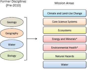
Realignment of USGS Mission Areas
Pragmatic reasons for the current assessment of the scientific directions for future USGS international activities relate, in part, to major organizational changes at USGS, implemented in 2010-2011 and based upon the science strategy developed in 2007 (see Box 1.3). The reorganization resulted in a new strategy that moved the USGS from a discipline-focused agency to one focused on the application of integrated Earth science in support of critical mission areas.
An additional motivation for the current assessment is the DOI Strategic Plan for 2011–2016 (see Box 1.4), which cites science as a key component of the DOI mission and
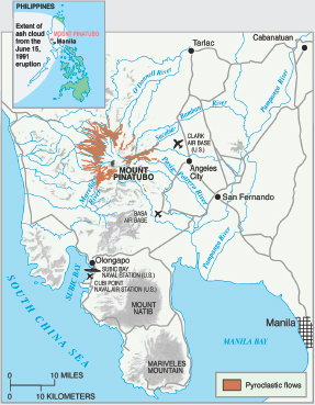
FIGURE Before the eruption more than 1 million people lived within 30 miles of the volcano, including more than 15,000 American military personnel and their dependents. SOURCE: Newhall et al. (1997).
an essential, cross-cutting element that assists bureaus in land and resource management and regulation. The Strategic Plan also identifies the USGS as DOI’s primary science organization, with sister bureaus conducting mission-specific research to support their programs, and outlines the following goals for the USGS:
- ensure the quality and relevance of science products to partners and customers;
- provide science for sustainable resource use, protection, and adaptive management;
- provide scientific data to protect and inform communities; and
- develop a comprehensive science framework for understanding the Earth.
BOX 1.3
USGS Science Strategy 2007-2017
As part of an ongoing effort to respond to evolving national and global priorities, the USGS (2007) report—Facing Tomorrow’s Challenges: U.S. Geological Survey Science in the Decade 2007-2017—examined the Survey’s major science goals and proposed a new science strategy with six science directions:
- Understanding Ecosystems and Predicting Ecosystem Change: Ensuring the nation’s Economic and Environmental Future
- Climate Variability and Change: Clarifying the Record and Assessing Consequences
- Energy and Minerals for America’s Future: Providing a Scientific Foundation for Resource Security, Environmental Health, Economic Vitality, and Land Management
- A National Hazards, Risk, and Resilience Assessment Program: Ensuring the Long-Term Health and Wealth of the Nation
- The Role of Environment and Wildlife in Human Health: A System that Identifies Environmental Risk to Public Health in America
- A Water Census of the United States: Quantifying, Forecasting, and Securing Freshwater for America’s Future
In addition, the 2007-2017 Science Strategy recognized the essential role in all USGS science goals of expanded information technology and other crucial emerging technologies to allow for the seamless sharing of data and information—a field now known as core science systems.
________________________
SOURCE: USGS (2007)
To fulfill these goals, and in keeping with the science directions proposed in 2007 (see Box 1.3), the USGS during 2010 and 2011 has restructured its budgeting and reporting under seven mission areas (see Figure 1.1):
- Climate and Land-Use Change
- Core Science Systems
- Ecosystems
- Energy and Minerals
- Environmental Health
- Natural Hazards
- Water
The mission areas correspond to the science directions described in the 2007 document, with two exceptions: first, the mission area on Core Science Systems was not an original science direction but was elevated to a main science direction during the organizational
BOX 1.4
Department of the Interior Strategic Plan, 2011-2016
The U.S. Department of the Interior Strategic Plan for 2011–2016 provides a blueprint for guiding and prioritizing its investments and resource allocations. The strategic goals are categorized in five missions areas: (1) provide natural and cultural resource protection and experiences; (2) sustainably manage energy, water, and natural resources; (3) advance government-to-government relationships with Indian Nations and honor commitments to insular areas; (4) provide a scientific foundation for decision making; and (5) build a 21st century DOI. The role of the USGS corresponds to the fourth mission for carrying out the Department’s strategic vision.
The Strategic Plan also indicates that “International Engagement and Leadership” is one of the DOI’s key principles and tenets and states that the Department
participates in the United States’ efforts to address climate change; protect biodiversity; sustainably manage energy, water, and natural resources; empower indigenous communities; protect cultural heritage; and ensure sound science as the basis for decision making. The resources for which Interior is responsible cross jurisdictional boundaries and Interior is a key player in the international community confronting the exploitation of natural resources, trade in wildlife, spread of invasive species, and in a multiplicity of scientific issues. The Department is committed to maintaining its relevance and will engage in international efforts as a core mission responsibility, consistent with its unique expertise and mandate.
________________________
SOURCE: DOI (2011).
changes in 2010; second, the Role of Environment and Wildlife in Human Health scientific direction (see Box 1.3) is now simply called “Environmental Health.” The strategic science directions remain the focal areas for the seven national mission areas, and the international activities that impact these missions are the subject of this study. Hereafter the committee uses the term “mission area” when referring to one or more of the Survey’s seven areas of science priority.
STRUCTURE OF THE USGS OFFICE OF INTERNATIONAL PROGRAMS
The USGS Office of International Programs (OIP) is responsible for representing all USGS scientific disciplines in the international arena. Formerly the Office of International Geology, the OIP became a bureau-level office in 1995 under the Associate Director for Geology; with the implementation of the new USGS strategy in 2010, it was administratively placed under the Director of the USGS.
The Office has specialists who represent USGS interests and activities in five regions around the world: Europe and the former Soviet Union; Africa and the Middle East;
*The mission areas Environmental Health and Energy and Minerals are cross-serviced by (i.e., receive shared support from) the same USGS Leadership and Management Team, although they are distinct mission areas with their own science strategies.
FIGURE 1.1 Reorganization of USGS from a discipline-focused agency to one involved in the application of integrated science in support of critical mission areas. SOURCE: USGS; see also www.usgs.gov/start_with_science/.
Asia and the Pacific; Latin America and the Caribbean; and Canada, the Arctic, and the Antarctic. These five specialists represent the USGS in discussions about potential international projects with organizations such as USAID, DOS, Department of Defense, and the World Bank.
In addition to the OIP, the Survey’s Bureau Support Unit provides logistical support for USGS international travelers (e.g., by obtaining passports and visas). Detailed information about the functions of the OIP and the development of international projects is provided in Chapter 2.
SCOPE AND STRUCTURE OF THE REPORT
To address the three specific points identified in the committee’s statement of task as well as the more general points related to international collaborations and interactions that support and enhance USGS strategic science directions and U.S. government national and
international objectives (Box 1.1), the remainder of this report is organized into five chapters. Chapter 2 provides an overview of the context and history of the USGS as a basis for understanding past and present drivers, priorities, and arrangements for its international activities. Chapter 3 addresses a key component of the committee’s statement of task, which states that the study will—in collaboration with the USGS—provide a summary of past and present USGS international scientific interactions and collaborations. The chapter additionally identifies where these activities have supported the overall USGS mission and/ or U.S. government needs.
Considerable input for Chapters 2 and 3 was derived from a document drafted by the USGS in response to a request from the committee to help inform this report (Appendix C). Although these two chapters present background and historical information without the views and analysis of the authoring committee, the committee recognizes the importance of evaluating which projects may return the greatest benefits to the Survey in the international arena. Indeed, the statement of task asked the committee to “identify where these activities are most effective in supporting the USGS mission or U.S. government needs.” However, a complete listing of all international activities historically and currently undertaken by the Survey was not available to the committee. Nor were other international project data available that would have enabled the committee to examine study effectiveness in a systematic and objective manner. Thus, rather than providing a priority ranking of those international activities that are most effective in supporting the USGS mission or U.S. government needs, Chapter 3 presents selected examples of international activities that demonstrate the breadth and depth of the USGS international engagement.7
Chapter 4, “Strategic International Science Opportunities for the USGS,” describes potential new international endeavors that the committee deems particularly compelling for the USGS to consider undertaking. This chapter addresses another component of the statement of task, which is to identify areas in which USGS involvement in international activities would, over the next 5 to 10 years, have high potential to benefit USGS strategic science directions or U.S. government international priorities. Chapter 5 addresses the final component of the statement of task: to identify impediments to more effective USGS participation in international science activities. Chapter 6 summarizes the committee’s major findings and recommendations.
Early in the 21st century, we are seeing rapid and accelerating global changes in the environment that directly affect humans. As populations increase globally and worldwide
__________________
7 Note that the committee interpreted “international” activities to include those where participating USGS scientists may or may not conduct physical fieldwork in a foreign country; for example, the committee includes in its descriptions some projects that involve collection and analysis of remotely sensed data.
exchange of information becomes more instantaneous, U.S. political, economic, and environmental interests are increasingly linked with those of the rest of the world. Multiple approaches are required to solve scientific problems domestically and abroad, and the USGS is in a position to address pertinent government priorities by working in coordination with other federal agencies and organizations and by applying scientific expertise to address pressing issues with an international dimension. Examination of the compelling international scientific opportunities that the USGS might pursue in the Earth sciences is thus timely and appropriate.
Devine, J.F. 2011. “The USGS: An Introduction.” Presentation to the Committee on Opportunities and Challenges for International Science at the U.S. Geological Survey (USGS), February 14, Washington, DC.
DOI (U.S. Department of the Interior). 2011. Strategic Plan for Fiscal Years 2011–2016. Available at www.doi.gov/bpp/data/PPP/DOI_StrategicPlan.pdf (accessed January 26, 2012).
DOS (U.S. Department of State). 2011. FY 2012 Department of State Operations Congressional Budget Justification. Washington, DC. Available at www.state.gov/s/d/rm/rls/statecbj/2012/ (accessed January 26, 2012).
NRC (National Research Council). 2001. Future Roles and Opportunities for the U.S. Geological Survey. Washington, DC: National Academy Press.
Newhall, C., J.W. Hendley II, and P.H. Stauffer. 1997. Benefits of Volcano Monitoring Far Outweigh Costs—The Case of Mount Pinatubo. U.S. Geological Fact Sheet 064-97. Available at pubs.usgs.gov/fs/1997/fs115-97/fs115-97.pdf (accessed January 26, 2012).
NSTC (National Science and Technology Council). 2007. A Plan for a U.S. National Land Imaging Program. A Report of the Future of Land Imaging Interagency Working Group. Washington, DC: NSTC.
NSTC. 2008. Scientific Assessment of the Effects of Global Change on the United States. A Report of the Committee on Environment and Natural Resources. Washington, DC: NSTC.
NSTC. 2010. National Aeronautics Research and Development Plan. A Report of the Aeronautics Science and Technology Subcommittee. Washington, DC: NSTC.
USGS (U.S. Geological Survey). 2007. USGS Facing Tomorrow’s Challenges: U.S. Geological Survey Science in the Decade 2007-2017: U.S. Geological Survey Circular 1309. Available online at pubs.usgs.gov/circ/2007/1309/ (accessed September 29, 2011).
Withee, G.W. 2011. “USGS International Program Perspectives.” Presentation to the Committee on Opportunities and Challenges for International Science at the U.S. Geological Survey (USGS), February 14, Washington, DC.


