
Chapter 4
Overarching Themes and Conclusions
The St. Johns River Water Supply Impact Study (WSIS) was designed to be a broadranging examination of the potential ecological effects of water withdrawals from the St. Johns River and its largest tributary, the Ocklawaha River. Its execution involved a large number of District scientists and consultants (almost 80 individuals) allocated among eight work groups in a two-phase effort extending over four years. In this regard, the District should be applauded for the scale and seriousness of the efforts expended to evaluate potential impacts of water withdrawals on the hydrology of the river and on the major components of the aquatic and semiaquatic ecosystems of the river system. The scope of the studies undertaken in the WSIS was unusually comprehensive relative to other environmental impact analyses with which the Committee members are familiar. In contrast to most of those studies, which rely on existing data, the WSIS also involved extensive collection of new data, at least for some ecological components.
The genesis for the WSIS was a water supply planning study conducted by District scientists in the middle of the past decade, which showed that continued reliance on groundwater resources in the St. Johns drainage basin would lead to unacceptable declines in the piezometric surface of the Floridan Aquifer (the principal aquifer used for potable water supply in the region). The modeled declines in the piezometric surface with additional withdrawals were projected to cause unacceptable damage to native vegetation, especially in areas around the Orlando and Jacksonville metropolitan areas, in some cases as soon as 2013. Now that the WSIS is nearly complete and the District has evaluated the nature and extent of deleterious ecological impacts likely to occur as a result of future withdrawals from the St. Johns and Ocklawaha Rivers, it would be useful for the District to reexamine the results from their earlier groundwater study and compare the level and nature of negative impacts associated with withdrawals from the two (surface and groundwater) sources of additional water supply for the region.
SUMMARY OF RESULTS AND GENERAL CONCLUSIONS
Integration of the disparate results from all the workgroups into meaningful conclusions about overall impacts is a very difficult activity in any broad-based environmental impact assessment. The District accomplished this by assigning an effect rating to each metric used by an environmental workgroup using common criteria based on strength, persistence, and diversity (see Chapter 3). Although each workgroup had to independently interpret the three facets of an effect as they related to their specific metrics, and some workgroups used more quantitative data and information than others, the Committee is confident that the effects rankings can be
compared across environmental workgroups. This is a consequence of the substantial and increasing interactions between workgroups that the Committee witnessed over the course of two years, the overlap between scientists working on multiple workgroups, and the oversight of the Lead Scientist Ed Lowe, who provided continual input to the workgroups as they developed their rankings.
Several tables summarizing the results of the WSIS [found in Lowe et al. (2011)] are presented below. Table 4-1 shows the effects, ranging from negligible to extreme, for each of the major hydrologic drivers, by river segment. This table can be considered to represent the worst possible realistic scenario, as it includes a large withdrawal and 1995 land use, but completion of the upper basin projects and no sea level rise. Changes in flow rate precipitated by scenario FwOR1995PN are predicted to have moderate effects in segments 1-3 on fish and (consequently) wildlife. Also in the estuarine portion of the river, changes in salinity are expected to have moderate effects on wetlands vegetation and minor effects in benthic macroinvertebrates. Water age effects brought about by withdrawal are expected to have minor impacts on the plankton communities in segments 2-4. Changes in water level in river segments 5-8 are expected to moderately affect wetlands, fish, and wildlife. Finally, entrainment or impingement could have major effects on fish in upper basins locations where the withdrawal is likely to occur, but these could be ameliorated by proper intake design, as noted in Chapter 3. Considering all drivers, salinity in the lower river and water level changes in the upper river are likely to have the largest effects on river ecology, particularly on fish. Potential entrainment/impingement issues further highlight fish as a vulnerable ecological community.
More specific information can be gleaned from Table 4-2, which shows the levels of effects for each environmental workgroup by segment, under the scenario that was most extreme for that workgroup. The Full1995PN scenario was found to cause the most extreme effects for five workgroups (wetlands, biogeochemistry, benthos in the upper river, fish, and wildlife), and the effects range from negligible (for biogeochemistry) to moderate (for benthos, fish, and wildlife). The most extreme scenarios for the plankton and SAV workgroups produced only negligible effects. Summing these effects over all workgroups leads to the same results apparent in the final column of Table 4-1: moderate effects are likely in the lower river due to salinity and flow rate issues, and in the upper river due to changes in water levels. The District’s approach of using the lowest denominator in terms of a level of effect—across all metrics within a workgroup, across hydrologic drivers in Table 4-1, and across workgroups in Table 4-2—represents an application of the precautionary principle that is appropriate.
On the other hand, the workgroups did not appear to consider the possibility of “back-to-back extreme events in their analyses, e.g., two or three years of extreme drought in a row, which the Committee considers to be reasonably likely future situations. They also tended to present mean responses to perturbations of a given driver with little or no consideration of the variance in that response. Although mean values are considered the most likely responses from a statistical perspective, in analyzing potential environmental impacts of changes in driver variables it is important to consider ranges (or variances) of responses. Although such responses may be less likely than mean values, they may not have negligible probabilities and they also could be much more detrimental than the mean responses. The Committee remains concerned that the District did not consider such conditions sufficiently in their otherwise thorough analyses.
TABLE 4-1 Levels of Effects by H&H Driver and River Segment for the Most Extreme, Realistic Withdrawal Scenarios: FwOR1995PN for Segments 1-3 and Full1995PN for Segments 4-8. The affected ecological attributes are indicated with capital letters (Biogeochemistry, Plankton, Littoral Zone, Wetland Vegetation, Macroinvertebrate Benthos, Fish, Floodplain Wildlife).
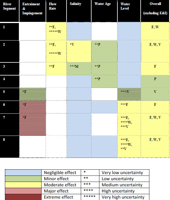
SOURCE: Lowe et al. (2011).
TABLE 4-2 Levels of Effects by Ecological Workgroup for Each River Segment. The scenarios indicated in the top row are the realistic scenarios with the strongest environmental effect for each attribute and segment combination.
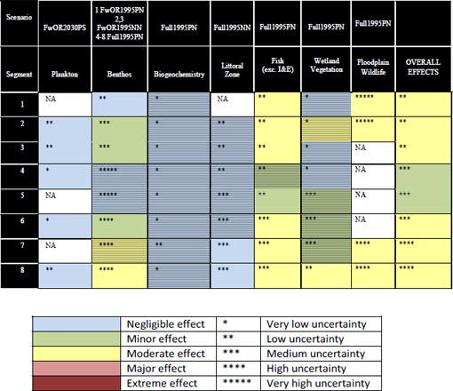
SOURCE: Lowe et al. (2011).
NOTE: Cross hatching indicates abbreviated analyses, which is not necessarily the same as in Chapter 3. Thus, for the SAV and biogeochemistry groups, hatching indicates that the workgroups did not model the effects of any realistic scenario. Their conclusions were based on the logic that negligible effects were found for the most extreme test scenario so all other scenarios, which all had weaker H&H effects, would also be negligible. In the case of the wetlands workgroup, they analyzed the Full1995NN scenario in the estuary (segment 2) and found moderate effects. Because the Full1995NN and Full1995PN scenarios had nearly identical H&H effects this far downstream, they concluded that the environmental effects also would be nearly identical to those for the Full1995NN scenario.
For each workgroup table on levels of effects (see Chapter 3), District scientists indicated the level of uncertainty associated with each ranking based on three factors: availability of a predictive model, existence of supporting evidence, and the workgroup’s understanding of the mechanism for an effect. For Tables 4-1 and 4-2, the largest uncertainty ranking given for a workgroup was used. The number of uncertainty asterisks in the final column on overall effects reflects the uncertainty in the entry with the greatest effect. The estimates of uncertainty produced by most of the workgroups were reasonable; that is, the Committee is not surprised that most of the results are associated with a moderate or even high level of uncertainty. Overall, the
Committee considers the District’s cross-workgroup synthesis efforts as the WSIS was drawing to a close to be appropriate and done well, particularly in comparison with many previous environmental impact analyses.
The NRC Committee became involved with the WSIS toward the end of Phase I (early 2009). At that time, the objective to examine the effects of surface water withdrawal on a broad range of environmental issues seemed to be quite an undertaking (and perhaps unrealistic) given the available data and disparate (and somewhat limited) proposed paths of analysis. However, as the study progressed and the Committee presented its comments, relevant data were collected and the analytical work was increasingly conducted along biological “chains of causation.” The District scientists welcomed the Committee’s recommendations and implemented them when feasible, thus overcoming many of the limitations noted by the Committee early on in the project. The Committee commends the WSIS workgroups for their careful and thoughtful responses to its suggestions. Overall, the draft versions of the workgroup reports reviewed by the Committee reflect positively on the seriousness, level of effort, and competence of the WSIS participants, and especially the leadership of the group. The Committee views the synthesis chapter (Lowe et al., 2011) as state-of-the-art in real-world analysis of large aquatic systems by management agencies. In the end, the District did a competent job relating the predicted environmental responses (including their magnitude and general degree of uncertainty) to the proposed range of withdrawals. The overall strategy of the study and the way it was implemented were appropriate and adequate to address the goals that the District established for the WSIS.
Even the workgroups that were stymied by a lack of relevant data and information, such as the biogeochemistry and freshwater benthos workgroups, were able to produce defensible conclusions about the likelihood of effects from water withdrawals in the upper river segments (albeit with high uncertainty). Of course, this is not to say that the Committee agreed with all the conclusions in the workgroup documents. Insofar as the H&H results indicate that withdrawals will produce relatively small changes in areas and depths of inundation, the inability of these workgroups to make more certain predictions is somewhat ameliorated. Indeed, had the WSIS benefitted from having the results of the hydrologic/hydrodynamic analysis at an earlier date, it is likely that the District would not have invested so much effort on determining some potential environmental responses to altered flows and levels. At a minimum, the workgroups would have been able to better focus their studies in areas with the greatest likelihood of impacts, and in some cases they might have decided that less field sampling and/or fewer experimental studies were needed.
The WSIS was a meaningful exercise in other important ways. First, the District scientists learned much about the system that the District manages. Second, the scientists gained experience in conducting large-scale environmental impact studies, and this resulted in improvements in their analyses over the period of the exercise.
Several critical issues that are beyond the control of the District or were considered to be outside the boundaries of the WSIS limit the robustness of the conclusions. These issues include future sea-level rises and increased stormwater runoff and changes in surface water quality engendered by future population growth and land-use changes. As discussed in Chapter 2, the predicted effects of some of these issues on water levels and flows in the river are greater in magnitude than the effects of the proposed surface water withdrawals, but they have high uncertainties. In addition, the relatively short period (ten years) of the rainfall record used for the hydraulic and hydrodynamic modeling and the assumption that it will apply to future climatic
conditions is a concern. The Committee recognizes that changing climatic conditions globally are rendering long-term historic records less and less useful in making extrapolations to future rainfall patterns, particularly for time periods in the more distant future (e.g., 25-50 years from now). The District should acknowledge this limitation in its final report and should plan to run its models with more recent rainfall records in an adaptive management mode.
The Committee continues to be somewhat concerned with the basis for the final conclusion that water withdrawals of the magnitude considered in the WSIS will not have many deleterious ecological effects. In large part, this conclusion was based on the model findings that increased flows from the upper basin projects and from changes in land use (increases in impervious urban/suburban areas) largely compensated for the impacts of water withdrawals on water flows and levels. Although the upper basin projects should be viewed as a positive influence insofar as they will return land to the basin (and water to the river) that belonged there under natural conditions, the same cannot be said about increased surface runoff from impervious urban- and suburbanization. The generally poor quality of surface runoff from such land uses is well known. Uncertainties about future conditions over which the District has no control (e.g., climate change, sea level rise, land use) also lead to concerns about the reliability of the conclusions. Finally, insofar as the MFL regulations limit the withdrawal allowable during low flow periods, these conclusions may be technically correct, but the Committee maintains substantial concern as to whether MFLs will be rigidly enforced in the future. If there is an extended drought in the future, when increased water supply demands have led to surface withdrawals, water suppliers might not be able to withdraw water from the river for months or even years on end. It is not obvious that this would be socially acceptable.
The WSIS operated within a range of constraints that ultimately imposed both limitations and uncertainties on the study’s overall conclusions. First, although large amounts of hydrologic data were available on the main stem of the river to conduct analyses and calibrate hydrodynamic/hydrologic models, data needed to understand surface water–groundwater interactions and for the environmental impact analyses were not as readily available. In some cases data were very limited. District scientists conducted some new monitoring and took advantage of other data collection programs, but the lack of data impeded the progress of some workgroups (see Chapter 3 for details) and led to uncertainties about some of the WSIS conclusions.
Second, some constraints reflect basic scientific limitations regarding our ability to predict future environmental conditions. For example, rates and extent of sea-level rise resulting from global climate change are uncertain (and controversial) at the time scale of several decades or longer, and long-term rates of population growth and land-use changes in the drainage basin also are very difficult to predict at multi-decadal time scales. Uncertainties in projections for these future conditions add to the final uncertainties in the District’s conclusions about water level (and other hydrologic) changes resulting from future water withdrawals and thus to uncertainties regarding related ecological impacts. For sea level rise, population growth, and land use change, the Committee recommends (as did the NRC, 2010 report) that the District revisit and update the projections in their periodic Source Water Assessment and Water Supply Plans to ensure the accuracy of their predictive models over time. Similar questions may need to
be asked about the certainty of water coming from the upper basin projects, in the unlikely event that they are not completed because of funding constraints or other priorities. All of these issues can be best dealt with if the District is able to adopt an adaptive management approach when considering future water withdrawals from the river, which key District staff have repeatedly expressed a desire to do.
A third kind of constraint is related to District assumptions concerning the ultimate fate of water withdrawn for municipal/domestic use. The District assumed in its hydrodynamic modeling to forecast withdrawal effects that wastewater inputs would remain at current levels of 5.2×10⁵ m3/d through the period of analysis (Sucsy et al., 2010). Under possible future conditions with greater uncertainty, the District modeled a scenario in which WWTP effluent would be reused by agriculture and/or industry and that effectively there would be no direct return of the water to the river or its tributaries, and it regarded this as a conservative assumption for the purpose of hydrologic modeling. This scenario showed only a “barely perceptible” reduction in water level and increase in salinity along the river, because most of the WWTPs are located in the lower SJR where natural flows and tidal effects are greatest.
In part because of the above assumption, the District did not include a separate workgroup on water quality impacts in the WSIS, and the potential effects of withdrawals on aquatic biota were assumed to result primarily from hydrologic changes. Similarly, runoff resulting from increases in urban/suburban land area in the basin was assumed to affect watershed hydrology only (within the constraints imposed by current regulations to retain stormwater flows in urban areas). The modeling conducted by the District did not have a water quality component, and the District considered the potential ecological effects of significant increases in degraded stormwater runoff, as well as changes in the frequency distribution of stream flows in urbanized areas, to be outside the scope of the WSIS. It most likely is true that such changes would not have important ecological effects on the main channel of the St. Johns River and on its large tributaries, and in this respect they can be considered to fall outside the “narrow confines of the WSIS.” Nonetheless, such effects are likely to be important in smaller streams draining newly urbanizing areas (which are giving rise to the need for surface water withdrawals from the St. Johns River in the first place!).
A fourth type of constraint reflects the inability to predict how other government entities not controlled by the District may change the river in the future. For example, deepening of the river channel in the stretch from Jacksonville to the mouth for military purposes to allow Navy vessels with deeper drafts to access the river has been proposed, but the District has no way of knowing whether this ever will happen. In order to give resource managers a way of assessing its relative importance, a scenario with a 50-foot deep channel was analyzed as a future condition with a high degree of uncertainty. It is important to note that simulations for this scenario indicated that dredging would have much larger effects on up-river movement of salinity than any of the water withdrawal scenarios the District examined.
Although the District included water withdrawals from both the main channel of the St. Johns River and from the Ocklawaha River in its withdrawal scenarios, the WSIS focused only on potential effects of the withdrawals on the hydrology and ecology of the St. Johns River (and associated riparian wetlands). The Committee expressed concern from the outset of this study about the exclusion from the WSIS of potential effects of withdrawals on the Ocklawaha River (NRC, 2009). The District gave two primary reasons for excluding the Ocklawaha River from the WSIS. First, an MFL study had not yet been conducted for the Ocklawaha, but one was planned for the near future. The District thought it would be premature to include the
Ocklawaha in the current WSIS without the existence of an MFL, which does exist for the main channel of the St. Johns River at Deland. Second, District scientists and administrators felt that a focus on the potential effects of water withdrawals on the main channel of the St. Johns River was a sufficiently complicated (and costly) undertaking of its own, and they did not wish to dilute that effort by including the Ocklawaha in the present study. The District has indicated, however, that it realizes the potential effects on the Ocklawaha do need to be addressed. The Committee wishes again to emphasize the importance of doing this analysis in a thoughtful and comprehensive way that is informed by lessons learned from the current study. Based on its review of the MFL study on the St. Johns River at DeLand, the Committee recommends that the District should use an approach for the Ocklawaha River study that is more similar in detail and scope to that of the current WSIS than the much less detailed and more cursory approach used in the St. Johns River-DeLand MFL study.
LESSONS FOR FUTURE STUDIES OF A SIMILAR NATURE
The goals, mission, and mode of operation of this Committee differed from those of typical NRC study committees, which are mandated to review and analyze existing information on a current (and usually controversial) issue and prepare a written report summarizing its conclusions and recommendations. Instead, the Committee was asked to provide reviews and advice regarding an ongoing scientific investigation. It did so not only through the means of written reports (of which this is the fourth and final), but also through substantive oral interactions during six meetings and four field trips of the full Committee. District scientists responsible for components of the WSIS provided oral presentations on their progress and other interested parties also made short presentations at these meetings. In addition, several conference call updates were provided between full meetings of the Committee on specific project components. Subgroups of the Committee, including the committee chair and staff officer, participated in these conference calls, which included slide presentations and were used to provide oral feedback to the District’s scientists.
Although the Committee maintained its independence and willingness to criticize throughout this process, it nevertheless viewed its role as more advisory than adversarial, and its primary goal was to provide timely advice to improve the quality of the WSIS. The District’s scientists generally responded favorably to recommendations made by the Committee and in most cases changed their approach to reflect these recommendations.
In the context of NRC studies, the responsibilities and approach of this Committee were not unique; indeed the Water Science and Technology Board has a history of providing advice to ongoing projects and studies (such as the USGS National Water Quality Assessment program, restoration of the Everglades, and numerous projects of the U.S. Army Corps of Engineers). Nonetheless, the Committee wishes to provide some perspectives that may be useful in guiding the design of future studies that are instituted, like the WSIS, to evaluate the potential environmental quality impacts of projects to develop/use a natural resource.
A simple but important piece of advice to those planning impact assessment studies like the WSIS is to “start early.” Study periods in most cases need to extend over several years, and for most efficient use of human and financial resources, they should be designed using a more linear (sequential) and less parallel approach. In the context of the present (WSIS) study, this means that the hydrodynamic and hydrologic modeling work should have been completed (or
nearly so) before commencing the ecological impact components of the project. In the Committee’s view, this would have been more efficient economically and also could have led to more effective studies on ecological impacts because the scientists responsible for those studies would have been able to focus better on the locations and types of ecological communities most at risk. The Committee is aware that the St. Johns River Water Management District had time constraints that made a longer, more linear study approach infeasible, but the general principle of “longer, more linear” rather than “shorter and more parallel” impact studies remains sound.
The primary conceptual model driving the WSIS can be summarized as follows:
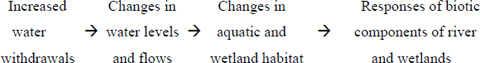
In most cases, the direct effects of water withdrawals on biotic components of the river and associated wetland ecosystems thus were viewed as mediated by changes in habitat conditions. In some cases, however, such as plankton and SAV responses, water quality changes induced by biogeochemical process changes associated with changes in water levels also were considered to be potential drivers of change. The focus on habitat change as a driver of biotic changes, coupled with the assumption that water withdrawn from the river would be used consumptively—that is, would not flow directly back into the river or its tributaries—led to a decreased emphasis on water quality impacts of water withdrawals in the WSIS as a whole. Even if the withdrawn water would not flow directly back into the St. Johns River or its tributaries, to the extent that it is not lost by evapotranspiration (a major fate of water used for irrigation), it will wind up somewhere, including in groundwater aquifers, where it may have impacts.
In retrospect, the Committee concludes that the WSIS should have included a water quality workgroup that addressed the effects of changing land use on runoff and return flow water quality throughout the basin. It is clear that future needs for additional water supplies in the St. Johns River basin will be driven by population increases that also will result in land-use changes—essentially increases in urban/suburban land cover—and increases in the production of wastewater effluent. Both of these changes are highly likely to affect surface water quality in the basin. The District argued that these considerations were beyond their scope and authority and that existing regulations such as NPDES permits and stormwater regulations would be sufficient to prevent water quality degradation. Although the Committee accepts the District’s argument that it lacks authority to control land use and population growth, it does not accept the view that this means the District has no responsibility to consider these issues in a study on the environmental impacts of surface water withdrawals.
In conducting the WSIS, District scientists found that the lack of basic data (e.g., certain kinds of benthos and fish information) and the inadequacy of basic analytical tools (e.g., on wetland hydrology and biogeochemical processes) limited what they were able to achieve and conclude. Some of these deficiencies could be overcome by future work of District scientists, and these needs should be addressed in the District’s medium- and long-term planning for future studies.
Lowe E., L. Battoe, D. Dobberfuhl, M. Cullum, P. Suscy, T. Cera, J. Higman, and M. Coveney.2011. Chapter 2 – Comprehensive Integrated Assessment of the draft final Water Supply Impact Assessment report.
NRC (National Research Council). 2009. Review of the St. Johns River Water Supply Impact Study: Report 1. Washington, DC: The National Academies Press.
NRC. 2010. Review of the St. Johns River Water Supply Impact Study: Report 3. Washington, DC: The National Academies Press.
Sucsy, P., G. Belaineh, E. Carter, D. Christian, M. Cullum, J. Stewart, and Y. Zhang. 2010. Hydrodynamic Modeling Results. December 2010, updated in May 2011 as Chapter 7 of the final H&H report.


