
This committee is charged with the task of discussing significant accomplishments of the restoration and assessing “the progress toward achieving the natural system restoration goals of the Comprehensive Everglades Restoration Plan [CERP]” (see Chapter 1). In this chapter, the committee updates the National Research Council’s (NRC’s) previous assessments of CERP and related non-CERP restoration projects (NRC, 2007, 2008, 2010). This chapter addresses programmatic and implementation progress as well as analyzes any natural system benefits resulting from the progress to date. This chapter ends with a short series of conclusions that encapsulate the committee’s general assessment of restoration progress.
PROGRAMMATIC PROGRESS
To assess programmatic progress the committee reviewed a set of primary issues that strongly influence the progress of the CERP toward its overall goals of ecosystem restoration. These issues, described in the following sections, relate to scheduling, planning, funding, cost-sharing, land acquisition, and endangered species. The following review represents the next iteration of a series of similar reviews by previous committees (Box 3-1).
Project Scheduling and Prioritization
The CERP project construction schedule through 2020 is outlined in the Integrated Delivery Schedule (IDS; Figure 3-1), which was developed in consultation with the South Florida Ecosystem Restoration Task Force (hereafter, simply the Task Force) and reflects the priorities of the CERP partners as well as sequencing constraints and other project implementation issues. The IDS is revised several times per year to reflect changing budgets and other developments that affect project schedules. A review of recent changes to the IDS reveals
BOX 3-1
Key Prior NRC Conclusions on CERP Programmatic Issues
NRC (2007):
“… there have been significant delays in the expected completion dates of several construction projects that contribute to natural system restoration…. The delays seem to be the result of a number of factors, including budgetary and manpower restrictions, the need to negotiate resolutions to major concerns or agency disagreements in the planning process, and a project planning process that can be stalled by unresolved scientific uncertainties, especially for complex or contentious projects.”
NRC (2008):
“The complex project planning and approval process has been a major cause of delays for CERP projects to date. The greatest challenge in the project planning process has been developing technically sound project plans that are acceptable to the many agencies and stakeholders involved…. The infrequent and unpredictable federal authorization mechanism for CERP projects has caused some additional problems and attendant delays.”
“Deficiencies in CERP system-wide planning are affecting the delivery of natural system restoration benefits. The CERP lacks a systematic approach to analyze the costs and benefits across multiple projects in support of project planning. Fundamentally, the CERP is designed as a system of related projects (i.e., components) that work together in the aggregate to produce overall restoration benefits. Without a system-wide planning process, it is not clear how system benefits can be optimized for any one project without any systematic consideration of other projects.”
“To reduce restoration delays, CERP planners should develop a stronger conceptual basis for multi-species recovery planning and management.”
NRC (2010):
“Given the slower than anticipated pace of implementation and unreliable funding schedule, projects should be scheduled with the aim of achieving substantial restoration benefits as soon as possible.”
that the anticipated pace of project construction has slowed significantly since the committee’s previous report (NRC, 2010). Of the 24 CERP and non-CERP project components in the most recent version of the IDS (August 2011) for which the scheduled construction can be directly compared to the March 2010 IDS, 14 were delayed (by an average of 3.4 years), 3 were accelerated (by an average of 1.3 years), and 7 had no change. In particular, NRC (2010) praised the acceleration of the Water Conservation Area (WCA)-3 Decompartmentalization and Sheetflow Enhancement (Decomp) project reflected in the March 2010 IDS, which showed all three phases of Decomp being completed by 2019.
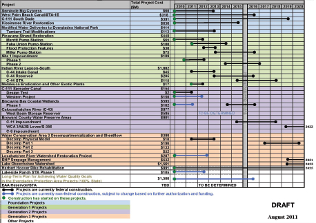
FIGURE 3-1 Integrated Delivery Schedule, August 2011 draft.
NOTE: Project costs cited represent October 2008 price levels and have been adjusted for inflation based on construction start and finish dates for each contract.
SOURCE: K. Tippett, USACE, personal communication, 2011.
By accelerating the Decomp project, which has been identified as the highest priority project for reversing ecosystem decline and advancing restoration (Ad Hoc Senior Scientists, 2007), the committee concluded that the March 2010 IDS was consistent with the goal of achieving substantial restoration benefits as soon as possible. Unfortunately, in the August 2011 IDS, the completion of Decomp Part 1 had been pushed back until 2020, and construction of the other two Decomp phases are to begin after 2020 (see Figure 3-1).
The August 2011 IDS separates the projects into groups largely defined by the timing of their authorization. The foundation projects represent non-CERP
(and largely pre-CERP) projects, such as Modified Water Deliveries to Everglades National Park (Mod Waters), C-111 South Dade, and the Kissimmee River Restoration. Generation 1 projects include those authorized in the 2007 Water Resources Development Act (WRDA; Picayune Strand, Site 1 Impoundment, Indian River Lagoon-South [IRL-S]) and the Melaleuca Eradication project, which was authorized within program authority. The construction of these projects is well under way (more detail on project-level progress is provided later in the chapter). Generation 2 projects include those projects that are anticipated to be included in the next WRDA bill, that is, projects with final or near-final project implementation reports (PIRs)—C-43, C-111 Spreader Canal, Biscayne Bay Coastal Wetlands, and Broward County Water Preserve Areas (WPAs). Two of the Generation 2 projects—C-111 Spreader Canal and Biscayne Bay Coastal Wetlands—have been the focus of expedited construction initiatives by the state of Florida. However, no federal funding can be provided to support continued construction progress until the projects are authorized. The Generation 3 projects reflect near-term priority projects for which project planning and development of a project implementation report (PIR) is far from complete. Note that the August 2011 IDS was published prior to the launch of the Central Everglades Planning Project (discussed later in this chapter).
Previous reports by this committee have noted that early authorizations have focused on more peripheral projects that have either strong local support or little opposition that would delay project planning. As a result, NRC (2007) concluded that “production of natural system restoration benefits within the Water Conservation Areas and Everglades National Park is lagging behind production of natural system restoration benefits in other portions of the South Florida ecosystem.” Although the C-111 Spreader Canal and Broward County WPAs would enhance seepage management in the central Everglades, the remaining Generation 2 projects largely target restoration benefits outside of the remnant Everglades. Projects such as Decomp and Everglades National Park (ENP) Seepage Management (both Generation 3) combined with Modified Water Deliveries to Everglades National Park (Mod Waters) and additional water storage for central Everglades restoration offer the most promise for restoration of the “core” Everglades. However, the August 2011 IDS shows completion of many of these projects beyond 2020.
In response to past NRC criticisms and recognizing the need to stem ecosystem declines in the remnant Everglades, the CERP agencies launched the Central Everglades Planning Project in October 2011 (described in more detail in the next section). This project aims to deliver an increment of restoration to the central Everglades as soon as possible within certain constraints, such as using only publicly owned land. The prioritization of restoration in the central Everglades and the proposal to advance increments of restoration as a means
of accelerating restoration is consistent with past committee recommendations (NRC, 2007, 2008, 2010). Meanwhile, the South Florida Water Management District (SFWMD) also appears to be prioritizing its investments toward further improvements to water quality to ensure compliance with the 1992 Consent Decree (discussed later in this chapter). As discussed in detail in Chapter 4, refocused efforts on the central Everglades and integrated water quality and quantity improvements are keys to reversing the declines in the historical Everglades.
Project Planning, Approval, and Authorization
A complex project planning, approval, and authorization process is in place for CERP projects (as described in NRC, 2007) that significantly affects the pace of project implementation. Past NRC reports have concluded that the federal planning process contributes to substantial restoration delays and does not effectively support system-wide planning (see Box 3-1). Senior CERP managers admit that the current U.S. Army Corps of Engineers (USACE) project planning and approval process frustrates local sponsors, Congress, and the USACE staff because it is time consuming, overly detailed, and expensive (S. Kopecky, USACE, personal communication, 2012). This section discusses a major initiative to address some of these planning and approval challenges, as well as continued delays in project authorization.
USACE Planning Transformation Pilots
In 2011, the USACE launched a nationwide pilot program to test a revised project planning and approval process to reduce the typical 6-year preauthorization timeframe to 18-24 months, while still addressing all current legal and programmatic requirements (such as National Environmental Policy Act [NEPA] and independent external peer review). The process requires a cultural shift toward less-detailed analyses and risk-based project planning. The process utilizes planning teams that consider what information is really needed to compare alternatives and reduce overall risk and includes early involvement by senior leadership and decision making at key project phases (or decision points).
At the heart of the revised process is a more aggressive and comprehensive early project scoping process. In the scoping phase, federal interest in the project is assessed, problems and opportunities are identified, and key assumptions and analysis plans are agreed upon (e.g., assessment measures, modeling tools, “future without project” conditions). The process compresses the scoping phase from three years into three months (Figure 3-2), which requires planners to balance and manage the level of detail in their considerations of benefits and
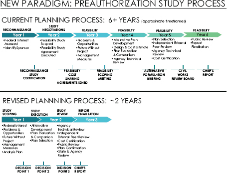
FIGURE 3-2 Comparison of the timeframes of the traditional USACE project planning and approval process against the revised planning pilot process.
SOURCE: Modified from S. Kopecky, USACE, personal communication, 2012.
uncertainty. Additionally, the process requires techniques to support extensive stakeholder involvement and public communication.
The USACE is testing its revised planning process with a nationwide pilot program focused on five projects—two navigation, one flood control, and two environmental restoration projects. The intent of the pilot program is three-fold: 1) demonstrate effectiveness and efficiencies of the new civil works planning paradigm, 2) inform future planning guidance, and 3) develop sustainable, replicable processes (S. Kopecky, USACE, personal communication, 2012). The
Central Everglades Planning Project was launched in October 2011 as one of the five pilots.
Central Everglades Planning Project
The purpose of the Central Everglades Planning Project is to substantially reduce the project planning and approval time for a suite of CERP project components to “improve the quantity, quality, timing, and distribution of water flows to the central Everglades (WCA-3 and [Everglades National Park] ENP)” (Box 3-2; USACE and SFWMD, 2012). Although the project focuses on the central Everglades, the redistribution of flows also could notably benefit the northern estuaries and Lake Okeechobee, and these benefits are included among the project objectives (Box 3-2; Figure 3-3). The scope of the project includes increments
BOX 3-2
Central Everglades Planning Project Purpose, Goal, and Objectives
Project purpose:
“The purpose of the CEPP [Central Everglades Planning Project] is to improve the quantity, quality, timing and distribution of water flows to the central Everglades (WCA 3 and ENP).”
Project goal:
“The goal of the CEPP is to improve the quantity, quality, timing, and distribution of water in the Northern Estuaries, Water Conservation Area 3, and Everglades National Park in order to restore the hydrology, habitat, and functions of the natural system.”
Project objectives:
• “Restore seasonal hydroperiods and freshwater distribution to support a natural mosaic of wetland and upland habitat in the Everglades system
• Improve sheetflow patterns and surface water depths and durations in the Everglades system in order to reduce soil subsidence, the frequency of damaging peat fires, the decline of tree islands, and saltwater intrusion
• Reduce water loss out of the natural system to promote appropriate dry season recession rates for wildlife utilization
• Restore more natural water level responses to rainfall to promote plant and animal diversity and habitat function
• Reduce high volume discharges from Lake Okeechobee to improve the quality of oyster and submerged aquatic vegetation (SAV) habitat in the northern estuaries”
SOURCE: USACE and SFWMD, 2012.
of a number of CERP project components described in the original restoration plan (the Yellow Book; USACE and SFWMD, 1999), such as the Everglades Agricultural Area Storage Reservoir, Decomp, seepage management, and rain-driven operations. The Central Everglades Planning Project shifts the planning emphasis from multiple independent project PIRs (each normally taking 6 or more years to complete) to a regional integrated PIR for the first increment of restoration on an expedited schedule of approximately 18 months. The central Everglades is an ideal pilot candidate for the USACE revised planning process and offers the ability to move toward a more integrated planning process where benefits can be aggregated both spatially and across project components, thereby addressing criticisms of previous NRC committees (Box 3-1). The project also incorporates the incremental adaptive restoration approach (NRC, 2007) as a means of moving forward with increments of restoration as quickly as possible, while learning in ways that enhance subsequent project designs. The process is early in its 18-month timeframe, and as of May 2012, there were no publicly available decision documents for the committee to evaluate.
Assessment
The proposed USACE planning transformation is clearly not business as usual. It is a striking change to a process and culture that have existed for some time, and it directly addresses several concerns raised by earlier reports of this Committee (see Box 3-1; NRC, 2007, 2008, 2010). The inclusion of the Central Everglades Planning Project as one of five nationwide pilots is both responsive to a recognized need for planning acceleration and a true test of the revised process. The USACE is to be commended for undertaking this much needed and ambitious effort.
The Central Everglades Planning Project team has identified several concerns and limitations in the Draft Project Management Plan (USACE and SFWMD, 2012). The timeframe of the Central Everglades Planning Project does not allow for the development of new planning tools or approaches that could help to facilitate the process. One of the most substantive concerns is the time available for formal approval of critical models, including the “local” model used to evaluate and compare project alternatives. The time required for USACE model approval may hamper the completion of the Central Everglades Planning Project within the 18-month target period. Another concern centers on the fact that data and design will be limited compared to those available during conventional project scope definition and PIR development. The prospect of greater uncertainty during the scoping phase is well recognized by the transformation process itself, although the formal methods for managing it have not been fully articulated and vetted. By recognizing and addressing these issues, the Project
Delivery Team can help to advance the Central Everglades Planning Project toward a timely, successful conclusion.
Project Authorization
Once project planning is complete and the USACE Chief of Engineers approves the PIR (also called the Chief’s Report; see Figure 3-2), the project is submitted to Congress for authorization. Water Resources Development Acts have served as the mechanism to congressionally authorize Everglades restoration efforts and specific CERP projects (see Appendix C). The CERP was formally launched by WRDA 2000 and included authorizations for 4 pilot projects, 10 initial Everglades restoration projects (pending congressional approval of the PIRs), and an adaptive management and monitoring program. All other projects with costs exceeding $25 million1 must be individually authorized by Congress. WDRA 2000 stipulated that the initial project authorizations are subject to Section 902 of WRDA 1986, thereby requiring reauthorization if project costs increase by more than 20 percent of the original authorized cost (exclusive of inflation). As a result of the Section 902 limits or other major project changes, all 10 conditionally authorized projects now require reauthorization (S. Appelbaum, USACE, personal communication, 2012).
The CERP planning process was developed with the assumption that WRDAs would be passed every two years, but this has not occurred. Since WRDA 2000, Congress has passed only one WRDA; WRDA 2007 authorized Indian River Lagoon-South, Picayune Strand Restoration, and the Site 1 Impoundment Projects (Figure 3-4). Federal funding has been appropriated for construction of all three of these projects plus the Melaleuca Eradication, which was authorized under programmatic authority (see Table 3-1). Without additional congressional authorizations, no new CERP projects can receive federal appropriations to support construction. Since 2007, Chief’s reports have been issued for four additional projects (C-43 Reservoir, C-111 Spreader Canal, Biscayne Bay Coastal Wetlands, Broward County Water Preserve Areas. These four projects represent the Generation 2 CERP projects (Table 3-1). Without passage of a new WRDA (or some other mechanism) to authorize these additional restoration projects, the federal government will be unable to maintain progress on several state-expedited projects now under way (e.g., C-111 Spreader Canal, Biscayne Bay Coastal Wetlands). The uncertain and sporadic occurrence of WRDA legislation has the potential to severely impede CERP progress, particularly for the four projects with completed Chief’s Reports. Alternatives to using WRDA for project authorization may be
____________________________
1Programmatic authority for smaller projects (less than $25 million each) was subject to a total limit of $206 million (WRDA 2000).
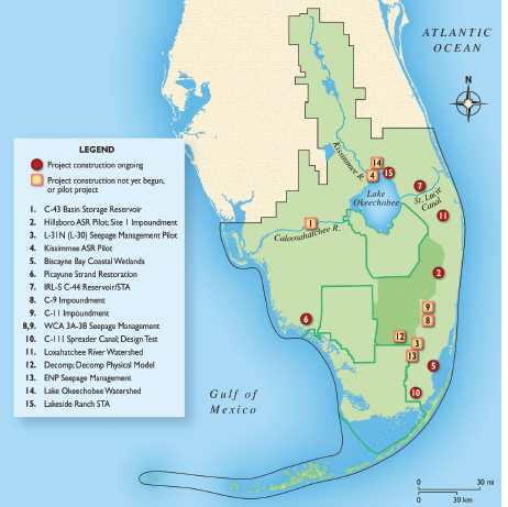
FIGURE 3-4 Locations of CERP and CERP-related projects and pilots listed in Table 3-1. Projects actively under construction are noted with a dark circle.
SOURCE: © International Mapping Associates
TABLE 3-1 CERP or CERP-related Project Implementation Status as of March 2012.
| Project or Component Name | Yellow Book (1999) Estimated Completion Date | 2010 Estimated Completion Date (NRC, 2010) | IDS (Aug. 2011) Estimated Completion Date | |
| PILOT PROJECTS | ||||
| Hillsboro ASR Pilot (Fig. 3-4, No. 2) | 2002 | 2009 | Not specified | |
| Kissimmee ASR Pilot (Fig. 3-4, No. 4) | 2001 | 2012 | Not specified | |
| Regional ASR Study | NA | NA | Not specified | |
| L-31N (L-30) Seepage | 2002 | 2010 | On hold | |
| Management Pilot (Fig. 3-4, No. 3) | ||||
| LPA Seepage Management Pilot (Fig. 3-4, No. 13) | NA | NA | Not specified | |
| C-111 Spreader Canal Design Test (Fig. 3-4, No. 10) | NA | 2011 | 2011 | |
| Decomp Physical Model (Fig. 3-4, No. 12) | NA | 2014 | 2014 | |
| RESTORATION PROJECTS—Generation 1 | ||||
| Picayune Strand Restoration (Fig. 3-4, No. 6) | 2005 | 2015 | Merritt: 2012 Flood Prot: 2013 Faka-Union: 2014 Miller: 2016 | |
| Site 1 Impoundment* (Fig. 3-4, No. 2) | 2007 | 2013 | Phase One: 2013 Phase Two: TBD | |
| Indian River Lagoon-South (Fig. 3-4, No. 7) | 2023 | Not specified | ||
|
- C-44 Reservoir/STA* |
2007 | 2014 | 2018 | |
| Melaleuca Eradication and Other | 2011 | 2026 | 2012 | |
| Exotic Plants | ||||
| RESTORATION PROJECTS—Generation 2 | ||||
| C-111 Spreader Canal* | 2008 | |||
|
- Western Project (PIR#1) |
2011 | 2012 | ||
|
(Fig. 3-4, No. 10) |
||||
| Biscayne Bay Coastal Wetlands | 2018 | 2011 | 2016 | |
| (Phase 1) | ||||
| (Fig. 3-4, No. 5) | ||||
| C-43 Basin Storage: West Basin | 2012 | 2013 | TBD | |
| Storage Reservoir | ||||
| (Fig. 3-4, No. 1) | ||||
| Broward County WPAs | ||||
| - C-9 Impoundment* (Fig. 3-4, No. 8) | 2007 | 2014 | Not specified | |
| - Western C-11 Diversion Impoundment* (Fig. 3-4, No. 9) | 2008 | 2014 | 2018 | |
| - WCA-3A & -3B Levee Seepage Management* (Fig. 3-4, No. 8,9) | 2008 | 2017 | 2022 | |
| PIR (or PPDR) Status | Authorization Status | Planning/ Design | Construction Status; Installation and Testing Status for Pilots | |
| PPDR Final | Authorized in WRDA | Completed | Installed 2008; Testing | |
| Oct. 2004 | 1999 | ongoing | ||
| PPDR Final | Authorized in WRDA | Completed | Installed 2008; Testing | |
| Oct. 2004 | 1999 | ongoing | ||
| NA | NA | Completed | Ongoing | |
| PPDR Final May 2009 | Authorized in WRDA 2000 | Completed | On hold | |
| NA | NA | Completed | Ongoing | |
| NA | Programmatic Authority WRDA 2000 | Completed | Testing completed | |
| NA | Programmatic Authority WRDA 2000 | Completed | Ongoing | |
| Submitted to Congress in 2005 | Construction Authorized in WRDA 2007 | Completed | Prairie Canal completed in 2007 (expedited by FL); Merritt, Faka Union ongoing | |
| Submitted to Congress in 2006 | Construction Authorized in WRDA 2007 | Ongoing | Ongoing | |
| Submitted to Congress in 2004 | Construction Authorized in WRDA 2007 | Completed | Ongoing | |
| Final June 2010 | Programmatic Authority WRDA 2000 | Completed | Ongoing | |
| Approved by USACE Chief of Eng. in Jan. 2012 | Not authorized | Completed | Ongoing; expedited by FL | |
| Approved by USACE Chief of Eng. in May 2012 | Not authorized | Completed | Ongoing; expedited by FL | |
| Approved by USACE Chief of Eng. in Jan. 2011 | Not authorized | Completed | Not begun | |
| Approved by USACE Chief of Eng. in May 2012 | Not authorized | Ongoing | Not Begun | |
| Ongoing | Not Begun | |||
| Ongoing | Not Begun | |||
| Project or Component Name | Yellow Book (1999) Estimated Completion Date | 2010 Estimated Completion Date (NRC, 2010) | IDS (Aug. 2011) Estimated Completion Date | |
| RESTORATION PROJECTS—Generation 3 | ||||
| WCA-3 Decompartmentalization and Sheet flow (Decomp)a (Fig. 3-4, No. 12) | ||||
|
- Decomp Part 1 |
2010 | 2012 | 2020 | |
|
- Decomp Part 2 |
2010 | 2019 | Not specified | |
|
- Decomp Part 3 |
2019 | Beyond 2020 | Not specified | |
| Loxahatchee River Watershed | Not specified | Not specified | ||
| - C-51 and Loxahatchee (L-8 Basin) Reservoir (Fig. 3-4, No. 11) | 2011 | 2008 | 2012 | |
| ENP Seepage Management (Fig. 3-4, No. 13) | 2010 | 2016 | 2021 | |
| Lake Okeechobee Watershed (Fig. 3-4, No. 14) | 2015 | 2015 | 2023 | |
| -Lakeside Ranch STA (Fig. 3-4, No. 15 | 2010 | 2011 | Phase One: 2012 Phase Two: TBD | |
a Projects that were conditionally authorized in WRDA 2000, subject to approval of the PIR. NOTES: Projects in Table 3-1 reflect those CERP projects or pilot projects that are now identified in the IDS (April 2011 version) for construction start prior to 2020, and other projects deemed by the committee to be relevant to CERP progress. This table does not include non-CERP foundation projects or “other projects” as classified by the IDS. Gray shading of project names reflects projects being expedited and/or carried out entirely with state funding as of 2012. Gray shading of construction cells indicates past or present aspects of projects that were expedited with state funding. In most cases, design and/or construction of these projects was moving forward prior to the finalization of the project implementation report (PIR). NA = not applicable; TBD = to be determined.
SOURCES: DOI and USACE (2011); SFERTF (2011); L. Gerry, SFWMD, personal communication (2012); G. Landers, USACE, personal communication (2012); USACE and SFWMD (1999).
feasible, although the committee is not aware that such mechanisms are being contemplated at this time.
Funding for South Florida Ecosystem Restoration
Once projects are authorized, the pace of restoration progress largely depends on the flow of funding to support their construction. Funding for Everglades restoration comes from two primary sources: the federal government and the state of Florida (largely via the SFWMD and the Florida legislature). For reporting purposes, funding is divided in two broad categories, one for CERP implementation and
| PIR (or PPDR) Status | Authorization Status | Planning/ Design | Construction Status; Installation and Testing Status for Pilots | |
| Not authorized | ||||
| In development as part of CEPP | Ongoing | Not begun | ||
| Not begun | Not begun | Not begun | ||
| Not begun | Not begun | Not begun | ||
| In development | Not authorized | Ongoing | Expedited by FL | |
| On hold pending funding | ||||
| On hold (pending pilot) | Not authorized | On hold | Not begun | |
| In development | Not authorized | Ongoing | Not begun | |
| Ongoing; expedited by FL | ||||
the other for non-CERP restoration efforts. In the following section the committee reviews state and federal funding for restoration projects in the Everglades.
Financial History of Non-CERP and CERP Restoration Projects
Appropriations for non-CERP restoration projects, such as the Kissimmee River Restoration Project and Mod Waters, have been much greater than on CERP projects: $2.53 on non-CERP projects for every $1.00 on CERP projects. Non-federal partners have budgeted $3.28 for non-CERP projects for every $1.00 by the federal government (Table 3-2).
TABLE 3-2 Total Funding (in Millions) for CERP and Non-CERP South Florida Restoration Projects, FY 2002 to FY 2011 for Federal and Non-Federal Partners
| Federal (in million $) | State(in million $) | |
| CERP | 854 | 3,066 |
| Non-CERP | 2,150 | 7,045 |
| Total | 3,004 | 10,111 |
NOTE: This table includes appropriations, not precise expenditures, and cannot be used to calculate cost-sharing credits.
SOURCE: SFERTF (2012).
The CERP is a 50-50 cost-share program, but to date non-federal funding has been far greater than federal funding (Figure 3-5). Between fiscal year (FY) 2002 and 2011, the federal government appropriated a reported $854.0 million for the CERP, while the state of Florida budgeted nearly $3.1 billion (Table 3-2; SFERTF, 2012). It remains to be determined how much of that excess state funding is creditable to CERP cost-sharing, because cost-sharing credits are dependent on project partnership agreements that are signed for each project only after federal authorization and appropriation of federal funding. Federal funding for the CERP has increased in the past few years, while state funding has generally declined after a peak in 2007 associated with the launch of the Acceler8 program. Funding streams of the federal and state CERP partners are discussed in more detail in the following sections.
Recent Federal Funding for Restoration
Table 3-3 shows federal budgeted expenditures as reported in the Task Force cross-cut budget for FY 2009 through FY 2012. Funding in FY 2010 and FY 2011 was notably higher than in prior years, partially because of American Recovery and Reinvestment Act (ARRA) funding in FY 2010. More than 90 percent of CERP monies went to the USACE for major construction projects, pilot projects, and project planning and design, with some funding to the Department of Interior for CERP planning support.
A large portion of federal CERP funds have been directed toward planning and design, but increasingly federal funds are being directed toward construction. Of $561 million in federal CERP funding through FY 2010, $420 million was spent on design (75 percent), $101 million on construction of three authorized Generation 1 projects (Site 1 Impoundment, Picayune Strand, Melaleuca Eradication; 18 percent), and $41 million on land acquisition (7 percent). In
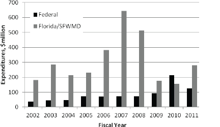
FIGURE 3-5 CERP-related expenditures by federal and non-federal partners.
NOTE: This figure includes all reported costs, including some that are not cost-shareable.
SOURCE: Data from SFERTF (2012).
FY 2011, nearly 70 percent of federal CERP funds were directed to project construction (K. Tippett, USACE, personal communication, 2011). Non-CERP projects continued to receive a large share of South Florida ecosystem restoration funds, and this funding has been relatively steady over the past four years. These funds are dispersed among a large number of projects and agencies; the major projects (>$5 million) are listed in Table 3-3.
Recent State Funding for Restoration
During the past three years several factors have stressed the SFWMD’s financial position, raising questions about its ability to continue funding Everglades restoration. Probably the most severe impact has been the decline of housing values in the service area, which has led to sharp declines in property (ad valorem) taxes. Florida had the third most foreclosures in the nation, leading to legislative mandates in 2008 to reduce property taxes. The current governor, who campaigned on a platform of tax reductions and government downsizing,
TABLE 3-3 Federal Budgets for CERP and Non-CERP Projects for FY 2009 to FY 2012 ($ millions)
| FY 2009 (enacted) | FY 2010 (enacted) | FY 2011 (enacted) | FY 2012 (requested) | |
| CERP Total | 93 | 215 | 126 | 88 |
| USACE (incl. ARRA) | 85 | 207 | 118 | 80 |
|
• Planning and design |
||||
|
• Construction at authorized projects (Site 1 Impoundment; Picayune Strand) |
||||
|
• Pilot projects |
||||
|
DOI |
8.4 | 8.5 | 8.4 | 8.4 |
| Non-CERP Total | 241 | 289 | 229 | 248 |
| Major projects (>$5 million): | ||||
|
C&SF Project (incl. ARRA) |
9.0 | 18 | 35 | 36 |
|
• C-111 S. Dade County |
||||
|
• West Palm Beach Canal |
||||
|
• Canal-51/STA-1E |
||||
|
Critical Projects |
3.5 | 2.7 | 5.2 | 1.0 |
|
USDA NRCS |
61 | 154 | 111 | 63a |
|
Kissimmee River Restoration |
28 | 45 | 7.0 | 46 |
|
Mod Waters |
60 | 8.4 | 8.0 | 8.0 |
|
Everglades National Park management |
30 | 31 | 30 | 31 |
|
DOI land acquisition |
0 | 0 | 0 | 31 |
|
USGS research, planning, and coordination |
6.9 | 6.9 | 6.9 | 6.9 |
a Wetlands Reserve Program funding amounts for FY 2012 are not included.
SOURCE: SFERTF (2012).
ordered a further 25 percent reduction in ad valorem taxes for FY 2012.2 A directive by a federal judge to address water quality in the Everglades Protection Area has compounded the agency’s fiscal challenges.
Florida relies on several sources of revenue to fund restoration, including (1) a portion of SFWMD’s ad valorem tax revenue; (2) an allocation from the Save Our Everglades Trust Fund (SOETF) administered by the Florida Department of Environmental Protection (FDEP) for the design, construction, and associated land costs for CERP projects; (3) the Florida Forever Trust Fund (FFTF), a state program for acquiring conservation and recreation lands, also administered by FDEP; and (4) $546 million in proceeds from Certificates of Participation issued by the SFWMD in November 2006 to fund Acceler8 projects. The time stream of revenues and expenditures for the SFWMD is shown in Figure 3-6. In six of the eight years shown (FY 2004-FY 2011), expenditures exceeded revenues. Deficits
____________________________
2The state legislature ultimately implemented a 30 percent reduction in ad valorem taxes.
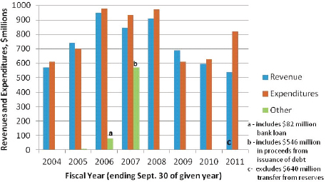
FIGURE 3-6 SFWMD revenues and expenditures, FY 2007 to FY 2011.
NOTE: To make revenues for FY 2011 consistent with earlier years, the budgeted $640 million transfer from fund balance was excluded from the revenue column.
SOURCE: Data from Statements of Revenues, Expenditures and Fund Balances, Comprehensive Annual Financial Reports FY2004-2010 and Updated Monthly Financial Statement for September 2011 (SFWMD, 2004, 2005, 2006, 2007, 2008a, 2009a, 2010, 2011a).
were covered either by bank loans, debt, or transfers from fund balances. Sharp declines in two parts of the revenue stream have affected the financial capacity of the SFWMD. Income from ad valorem taxes peaked in 2007 at $550 million when they accounted for two-thirds of revenue. In 2011 that source was $401 million, 27 percent less than in 2007. The FY 2012 budget includes only a projected $271 million from ad valorem taxes (SFWMD, 2012; L. Gerry, SFWMD, personal communication, 2012). Income from intergovernmental sources, particularly the state of Florida, also declined sharply. However, the SFWMD’s ability to continue funding restoration initiatives is buffered to some extent by large fund balances that have accrued over prior years (Box 3-3).
SFWMD Expenditures. District expenditures on individual projects from FY 2007 to FY 2012 (see Table 3-4) show that the SFWMD has spent substantial sums
BOX 3-3
Role of Reserve Funds
Large reserve fund balances play an important role in tempering the short-term effects of recent budget declines. These funds are held in numerous separate accounts, the totals for which are shown in Figure 3-3-1. A large boost in SFWMD reserves occurred in FY 2007 with the issuance of $546 million of debt. As of September 30, 2010, the total was $856 million (SFWMD, 2012), but a substantial transfer from those sources was made in FY 2011 to cover shortfalls in the budget and the $194 million cost of acquiring the U.S. Sugar lands. The SFWMD’s Monthly Financial Statement for September 2011 covering all expenditures for FY 2011 shows revenue from fund balances of $640 million, but only a portion of that was actually spent. When the tentative FY 2012 budget was submitted for approval in August 2011, it included a five-year $358 million plan to spend down fund balances, starting with an end-of-year projection of $417 million and leaving $59 million at the end of FY 2016 for contingencies and operations and maintenance of the capital reserve (SFWMD, 2011b). The actual end-of-year fund balance net of encumbrances was $475.5 million, considerably higher than the August projection (SFWMD, 2012).
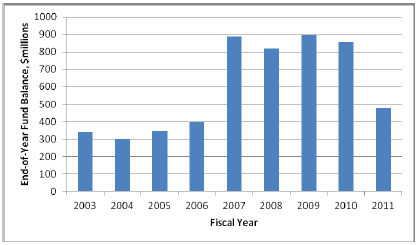
FIGURE 3-3-1 SFWMD total governmental fund balances, FY 2003-FY 2011.
SOURCES: Data from Comprehensive Annual Financial Reports FY 2004-FY 2010 and FY 2012 Budget Amendment passed February 9, 2012 (SFWMD, 2004; 2005; 2006; 2007; 2008a; 2009a; 2010; 2012).
TABLE 3-4 SFWMD Five-Year Expenditures (FY 2007-FY 2011) on CERP and CERP-related Projects and Programs
| PROJECT | FY 2007-FY 2011 Total Expenditures, $million |
| PILOT PROJECTS | |
| ASR Regional Study | 6.02 |
| GENERATION 1 PROJECTS | |
| Indian River Lagoon-South/C-44 Reservoir and STA | 107.07 |
| Picayune Strand | 33.01 |
| GENERATION 2 PROJECTS | |
| Biscayne Bay Coastal Wetlands | 35.64 |
| C-111 Spreader Canal | 19.61 |
| Caloosahatchee River Region C-43 Basin Storage Reservoir—Part 1 | 15.11 |
| Broward County Water Preserve Area (incl. C-11 Impoundment) | 14.70 |
| GENERATION 3 PROJECTS | |
| Loxahatchee River Watershed (North Palm Beach County—Part 1) | 196.62 |
| Lake Okeechobee Watershed | 56.41 |
| Everglades National Park Seepage Management | 11.22 |
| OTHER PROJECTS | |
| EAA Storage Reservoirs—Phase 1 | 242.95 |
| River of Grass | 225.54 |
| Southern Crew/Imperial River Flow-way | 13.56 |
| Lake Trafford Restoration | 9.17 |
| PROGRAM SUPPORT | |
| Acceler8 Program Support | 141.90 |
| Adaptive Assessment and Monitoring | 21.17 |
| Interagency Modeling Center | 11.13 |
| Data Management | 6.86 |
NOTE: Only projects with at least $5 million in total expenditures are included.
SOURCES: Caffie-Simpson et al. (2011); Carney et al. (2012); Williams et al. (2008, 2009, 2010).
on program support and on projects in Generations 1, 2, and 3, as well as the Everglades Agricultural Area (EAA) Reservoir, which is currently on hold. Many of the projects in Table 3-4 were originally part of the state’s Acceler8 program.
Projected expenditures in annual five-year capital budgets have been subject to considerable change over the past three years with deferral of some projects and reassignment of responsibility for construction of others from the SFWMD to the USACE. For example, the capital budget reported $228 million for the C-44 reservoir (part of IRL-S) in FY 2009-FY 2010, but the SFWMD spent less than $200,000 on the project during that time period (Caffie-Simpson et al.,
2011; Williams et al., 2010), and the FY 2011 five-year budget shows less than $15 million for the project. A similar fate befell the C-43 reservoir, a Generation 2 project whose five-year budget projections went from $171 million (FY 2009) to $2.8 million (FY 2010) to $14.2 million (FY 2011). SFWMD staff report that capital construction responsibilities for these projects are being transferred to the USACE (L. Gerry, SFWMD, personal communication, 2012). Five-year funding of the C-111 Spreader Canal, another Generation 2 project, was projected to be $77.9 million starting in FY 2009, with most of that scheduled for FY 2009, but the SFWMD spent only $19.6 million in FY 2009-FY 2011. While some large construction projects were deferred, funding for other projects increased in the FY 2010 five-year budget, including a new flow equalization basin, budgeted at $70 million, to enhance the performance of the stormwater treatment areas (STAs). Comparisons of the SFWMD’s capital improvement plans (CIPs) from FY 2009 through FY 2012 reveal a dramatic reduction in projected spending for restoration—particularly for Generation 1 and 2 CERP projects—as well as for overall spending. The FY 2009 five-year CIP included $1.63 billion for Everglades restoration in FY 2010 through FY 2013, including CERP and non-CERP Everglades Restoration (SFWMD, 2008b).3 The FY 2012 five-year capital budget for Everglades restoration is $544 million, one-third of the FY 2009 figure (Smykowski, 2012). Selected projects in the FY 2012 plan and contributions from the five-year reserves spend-down plan are shown in Table 3-5. Of special note is the $229 million projected five-year expenditure for the CERP, 48 percent of which is allocated to the Generation 3 project Loxahatchee River Watershed and another 34 percent to debt service. The only other CERP project with significant funding over the next five years is the C-44 Reservoir/STA (a Generation 2 project).
Cost-Sharing Challenges
The CERP is a partnership between the federal government and the state of Florida, with shared, equal financial responsibilities to support implementation of the project. However, according to USACE policy, the federal government is not permitted to outspend the non-federal sponsor at any point in the project. Although state funding for the CERP has far exceeded federal funding so far, the 50-50 cost-sharing requirements may hinder CERP progress in the years ahead because of reduced spending by the SFWMD on authorized projects.
____________________________
3The $1.3 billion included construction of the C-43 and C-44 reservoirs, which have now been transferred to the USACE. Additionally, the total included service on the debt for the acquisition of 180,000 acres of U.S. Sugar land, although ultimately only 26,000 acres were acquired without any additional debt.
TABLE 3-5 Selected Projects in Five-Year Capital Improvement Plan and Five-Year Reserves Spend-Down Plan (FY 2012-FY 2016)
| SFWMD Budget Category/Project | FY 2012-FY 2016 Five-Year Capital Improvement Plan ($millions)a | Contribution from FY 2012-FY 2016 Five-Year Reserves Spend Down ($millions)b |
| CERP TOTAL | 229 | |
| Loxahatchee River Watershed (L-8) | 110 | 69 |
| C-44 Reservoir/STA | 36 | 30 |
| C-111 Spreader Canal | 1 | |
| Debt Service | 79 | |
| DISTRICT EVERGLADES RESTORATION TOTAL | 315 | |
| Water Quality Enhancement Projects | 164 | 100 |
| Rotenberger Pump Station Design & Construction | 5 | |
| Compartment B Build-out | 5 | 5 |
| Compartment C Build-out | 6 | 6 |
| Debt Service and Debt Service Reserves | 128 | |
| COASTAL WETLANDS TOTAL | 34 | |
| Caloosahatchee Basin (C-43) Storage/Treatment and Facility | 21 | 19 |
| Local Projects | 12 | |
| Lakes Park Restoration | 2 | |
| LAKE OKEECHOBEE TOTAL | 60 | |
| Dispersed Storage (existing and new commitments) | 46 | 46 |
| Lakeside Ranch STA Phase I | 4 | 6 |
| Local Projects | 8 | |
NOTE: Projects only shown with five-year expenditures equal to or greater than $1 million.
SOURCES: a Smykowski, 2012; b SFWMD, 2011b.
Cost-sharing credits can only be tapped as matching funds for projects that have been authorized by Congress, have received federal appropriations, and have a signed formal project partnership agreement between the USACE and the SFWMD. As of early 2012, these include only the four Generation 1 projects: IRL-S (reservoir and STA components only4), Picayune Strand, Site 1 Impoundment— Phase 1, and Melaleuca Eradication. As of September, 2011, the USACE calculated that the state had outspent the federal government on these four Generation 1 projects by $270 million (see Table 3-6). Total estimated costs for the Genera-
_____________________
4The natural storage component of IRL-S does not yet have a signed PPA because only approximately one-third of the land for this component has been purchased. Water reservations—a prerequisite to the PPA—cannot be determined until the land is in public ownership.
TABLE 3-6 Calculated and Estimated Cost-sharing CERP Credits
| Federal (in million $) | Non-federal (State/SFWMD) (in million $) | Cost-Share Imbalance | |
| Creditable expenditures as of September 30, 2011 associated with existing PPAs (i.e., Generation 1 projects)a | 749 | 1,020 | 270 |
| Estimated creditable expenditures associated with Generation 2 projectsb | 76 | 584 | 508 |
a These creditable expenditures include costs associated with feasibility study cost-share agreements, all project design costs eligible for cost-sharing (includes Generation 2 and later projects), and land acquisition and construction expenditures for authorized projects (or project components) for which federal funding has been appropriated and a project partnership agreement has been signed. These include the Generation 1 projects, with the exception of Phase 2 of the Site 1 Impoundment and the natural storage feature of the IRL-S project.
b Actual creditable expenditures related to land acquisition and construction expenditures are determined once the project has been authorized, federal funding has been appropriated, and a project partnership agreement has been signed.
SOURCE: K. Tippett, USACE, personal communication, 2012.
tion 1 and 2 projects are listed in Figure 3-1. The agencies estimate that the cost share imbalance associated with Generation 2 projects exceeds $500 million. The extensive “creditable expenditures” associated with land acquisition and construction costs that the state has amassed related to other CERP projects (e.g., some components of the Generation 1 projects and all later projects) are essentially locked up until those projects are authorized, federal funding is appropriated, and a project partnership agreement is signed.
According to the five-year projected CERP expenditures reported in the 2012 South Florida Environmental Report, the SFWMD expects to invest only approximately $37 million over five years in Generation 1 CERP projects (Smykowski, 2012). Thus, if this budget plan were followed with no additional authorized projects and federal expenditures of $100 million/year (consistent with recent year budgets; see Table 3-3), total federal cost-share credits could exceed state credits in approximately three years, bringing the CERP to a standstill. To avoid the situation where federal government cost-share credits might exceed state credits, the SFWMD and the USACE are evaluating the cost-share balance on a regular basis. In the absence of new CERP congressional authorizations, two basic alternatives are feasible: 1) reduce federal CERP spending (on either design or construction), thus further delaying restoration progress, or 2) increase state spending, either through cash payments from the SFWMD to the USACE or by transferring construction of Generation 1 CERP projects (with project partnership agreements) from the USACE to the SFWMD. Given the SFWMD’s current
budget outlook, accrued state cost-share credits associated with Generation 2 projects are critical to the future CERP implementation progress, and utilization of those credits is dependent on congressional authorization.
Land Acquisition for Restoration of the Everglades
Land acquisitions for restoration projects include lands to implement CERP and non-CERP projects and additional lands to protect and enhance wildlife habitat. As project plans are modified, the estimates of land requirements shift, and the Task Force annually estimates land acquisition progress relative to restoration needs. The Yellow Book (USACE and SFWMD, 1999) estimated that 402,479 acres would be needed to implement the CERP, of which 182,338 acres (45 percent) were already in public ownership. The most recent Land Conservation Strategy report (SFERTF, 2010a) estimates the total land acquisition needs for the CERP to be 390,929 acres, with 234,853 acres (or 60 percent) already acquired at a cost of $1.7 billion. Approximately $1.8 billion is needed to complete the remaining CERP land acquisition. The vast majority of the remaining land acquisition needs are associated with surface water storage projects (SFERTF, 2010a). These totals do not include the SFWMD’s purchase of 26,800 acres from the U.S. Sugar Corporation, which closed in August 2010. Although the state retains an option on approximately 160,000 acres of U.S. Sugar land, future purchases are quite uncertain under prevailing economic conditions.
In September 2011, the Department of Interior announced a proposal to establish the Everglades Headwaters National Wildlife Refuge and Conservation Area, located northwest of Lake Okeechobee. If fully realized, the area would include up to 150,000 acres protected by conservation easements and land purchases to conserve habitats and protect the Kissimmee River watershed from development that could negatively impact Lake Okeechobee and Everglades water quality.
Endangered Species Issues
Past reports of this committee have highlighted concerns over the potential impacts of endangered species issues on restoration progress and emphasized the importance of multi-species management (NRC, 2008, 2010). In this section, the committee reviews the programmatic progress to address these issues and updates the outlook for potential concerns.
Multi-species Management in WCA-3A
For the past 15 years, issues involving endangered species have centered in WCA-3A, where flows through the S-12 gates have been regulated to protect
a population (population A) of endangered Cape Sable seaside sparrows (CSSS; Ammodramus maritimus mirabilis) in Everglades National Park to the south, resulting in most years in water impoundment at the southern end of WCA-3A. High water levels in southern WCA-3A produce several adverse ecological effects, and the overall water management regime in WCA-3A has negative impacts specifically on endangered snail kites, which are now on the brink of extirpation (NRC, 2010). In addition to wet season high water levels that have been too high and last too long, kites have been adversely affected by dry season flows that have been too low and rates of recession that have been too fast (FWS, 2010).
Since 2002 the water management policy for WCA-3A has been codified in an Interim Operation Plan (IOP) that is a result of consultation between the USACE, the SFWMD, and the U.S. Fish and Wildlife Service (FWS) about the CSSS issue. The IOP expired in November 2010 and is being replaced by the Everglades Restoration Transition Plan (ERTP). The FWS applied its recent Multi-species Transition Strategy for WCA-3A (FWS, 2010) when producing its Biological Opinion for the ERTP. ERTP features include new, lower thresholds for high water levels in the wet season and the addition of recession rate and minimum stage criteria for WCA-3A designed to provide appropriate hydrology to support kite nesting, foraging by wood storks and other wading birds, tree islands, and wet meadow vegetation. Regulations are more flexible, and increased flow to the south is made possible by the removal of closure dates for the S-12C gate in force during the IOP. The CSSS is as well protected under the ERTP (i.e., no changes in hydroperiods at the NP-205 gauge) as under the IOP because of the eastern location of S-12C relative to CSSS population A and the use of stoppers in the Tram Road to prevent water flowing through S-12C to the west. The ERTP provides for suitable hydrological periods for a suite of endangered species and other community components and thus represents multi-species management (FWS, 2010). It further represents precisely the management approach for which the NRC (2010) and others (SEI, 2007) have advocated, successfully applied to operations at what is perhaps the most volatile flashpoint in the degraded natural system.
The ERTP is in the final stages of authorization and likely will be implemented for the first time some time in 2012. It is not a panacea: its effectiveness will be constrained by the continuing problems that the CERP is designed to correct. Specifically its focus is on improving hydrology in southern WCA-3A without causing increased deterioration of conditions in Everglades National Park to the south, given the existing water management infrastructure and availability of water in the central Everglades. The cost of this approach is likely to be increased drying out of northern and even central WCA-3A, increasing the rate of degradation in those areas. The next hydrologic alteration will come with the
completion of the C-111 South Dade and Mod Waters projects (anticipated in 2013), when the ERTP will transition to a new water management plan known as the Combined Operational Plan (COP). However, the FWS has authorized the ERTP under the Endangered Species Act through 2016 to accommodate possible delays.
Some advocates for the CSSS view the ERTP as creating unacceptable risk to population A. Nevertheless, the ERTP represents a move by the FWS away from single-species, case-by-case management toward management that is broader in space and time and is better suited to handle the unexpected impacts on endangered species, both negative and positive, that certainly will arise during the transitional phase of CERP implementation.
Species Protection and STAs
The ongoing issues with endangered species in WCA-3A are a manifestation of continuing degradation of the natural system (see Chapter 4). In contrast, issues with endangered species and other birds in the STAs are new and representative of the sort of issues that are likely to arise repeatedly as the restoration proceeds. The STAs are new wetlands, and once operational they attracted droves of water birds, including nesting black-necked stilts (Himantopus mexicanus), which build nests at the end of the dry season (May-June) on the substrate in STA cells containing little or no water. In normal operations these cells would refill at the onset of the rainy season, which would destroy the stilt nests. Black-necked stilts are not endangered, but they are protected by the Migratory Bird Treaty Act. This elderly piece of legislation is less detailed than the Endangered Species Act and includes no provision for the FWS to authorize take. One approach to enforcing this legislation is use of an Avian Protection Plan, which was originally developed by the electric utility industry to address mortality from power line collisions. These plans, representing agreements between the FWS and the utility, are designed to reduce risk of avian mortality. Avian Protection Plans, by virtue of their existence, also reduce risk to the utility of enforcement (by the FWS) under the Migratory Bird Treaty Act, because the FWS considers willingness to negotiate an Avian Protection Plan sufficient evidence of concern for migratory birds. The SFWMD prepared an Avian Protection Plan for the original Everglades Construction Project STAs in cooperation with the FWS in September 2008, thus addressing the issue for these STAs. An Avian Protection Plan for a human-created and -managed wetland is unprecedented and viewed by the FWS as an important achievement.
The Avian Protection Plan includes a provision that managers should try to keep the water level in STA cells above 0.5 feet to prevent stilts from nesting. This same 0.5 feet criterion is found in the operating guidelines for the STAs.
Thus, managers can reduce stilt nesting by achieving their operating goals. When stilt nesting does occur, the Avian Protection Plan states that water must be diverted to other cells or STAs to avoid flooding of nests. The Avian Protection Plan appears to be working well thus far in that rerouting water to avoid flooding nests has had no significant impact on the operation of the STAs as a whole. Nesting occurs each year, more so in dry years such as 2009 when there were 873 stilt nests in the STAs, and there have been restrictions on individual STA cells each year (SFWMD and FDEP, 2012). However, no STA flow-ways have been restricted or taken off line to protect nesting birds, not even in 2009 (SFWMD and FDEP, 2010). The addition of flow equalization basins to the system (see Long-Term Plan later in the chapter) would reduce the frequency with which water levels in STA cells decline to levels that promote stilt nesting. The committee is not aware of any analysis that indicates that diverting water from individual cells to protect nesting birds has affected overall STA performance. In the absence of any such evidence, the Avian Protection Plan appears to provide a reasonable resolution to the issue.
The endangered species issue in the STAs involves the snail kite and appears to present more significant challenges than does the Migratory Bird Treaty Act. It is an unanticipated issue: in 2005 the FWS issued a non-jeopardy opinion as a result of its consultation on the original Environmental Impact Statement authorizing the construction of the STAs, concluding that the construction, operation, and maintenance of the STAs would have no adverse impact on snail kites (FWS, 2005). The SFWMD was given no authorization to “take” kites because the possibility of take was deemed unlikely. But in 2010 snail kites nested in significant numbers in STA 5 (Bearzotti et al., 2011). Managing for kites involves maintaining sufficiently high water prior to breeding, creating a suitable rate of recession thereafter, and maintaining a sufficient minimum stage during the dry season (FWS, 2010). In the STAs, normal operations maintain dry season low water levels suitable for kites, but nests can fail because of flooding from inflows, loss of food supply, or collapse of nest-supporting vegetation caused by rapid dry-down following outflows. Thus, nesting kites can affect STA operations in several ways over much of the year, and indeed kite nesting restricted operation of STA 5 for five months, and individual cells for an additional three months in 2010 (SFWMD and FDEP, 2012).
Currently, the SFWMD is consulting with the FWS about the effects of its STA operations on kites. Because Florida snail kites are considered to be near extirpation, loss of even a single kite or kite nest is a serious matter, and kite nests in STAs are being monitored and managed on a case-by-case basis to prevent any loss. Thus the approach to managing endangered species in the STAs is a single-species approach, in contrast to the multi-species approach applied in WCA-3A. Whether or not kites nest in STAs will depend on water levels and is
unlikely in relatively dry years—indeed there was only one kite nest in an STA in 2011, when wet season high water levels were lower than in 2010 (SFWMD and FDEP, 2012)—but there is no obvious way to prevent kites from nesting in STAs in a year when water levels are favorable without compromising the operation of the STAs. Thus, the issue will recur in wet years.
Managing Endangered Species in a Changing System
The Endangered Species Act is a powerful litigation tool (Ruhl, 2004) that can and has been used to prevent or modify water management necessary for system restoration but possibly detrimental to endangered species (NRC, 1995, 2004a,b). Several assessments have noted that although a fully implemented CERP should provide for the needs of all endangered species within the Everglades, detrimental effects are likely at particular locations in the transition between the future restored system and the current one (NRC, 2005; SEI, 2003, 2007). Recent developments in WCA-3A and the STAs exemplify such conflicts and suggest ways they might be resolved and/or avoided. Resolution of the conflict between kites and sparrows in WCA-3A through the ERTP illustrates the potential of a multi-species approach to endangered species management that is more compatible with system restoration than the typical single-species approach (NRC, 2005, 2010; SEI, 2007). Resolution of the stilt issue in the STAs illustrates flexibility and creativity of water managers and regulators in addressing unanticipated impacts of changes to the system resulting from a restoration action. The ongoing issue with kites in the STAs illustrates the reality of local conflicts with the needs of endangered species that can significantly compromise water management required for system restoration.
The flexibility, creativity, and multi-species approach applied in these recent cases represents important progress in the evolution of a strategy for handling such conflicts, but the kite issue in the STAs shows that more work remains to be done. The next step is to develop ways to apply the flexibility, creativity, and multi-species approach evident in these examples to larger spatial scales to reduce the frequency and significance of local conflicts. This will be essential for the CERP; otherwise it is likely there will be repeated delays as local endangered species issues arise and are resolved. Additionally, multi-species approaches can be used to lend weight to system-wide endangered species benefits that counter local costs. In the case of kites, for example, such an approach might involve assigning more weight to population performance and less to the fate of individual nests, and incorporating criteria that result in high and low water levels and recession rates favorable to kites into operational specifications for CERP projects.
CERP IMPLEMENTATION PROGRESS
The following analysis of implementation progress focuses on CERP restoration projects and pilot projects. Many of the restoration projects build upon benefits provided by non-CERP projects, which are discussed in the next section. Additional information on implementation progress can be found in the 2010 CERP Report to Congress (USACE and DOI, 2011) and the 2011 Integrated Financial Plan (SFERTF, 2011). Past reports of this committee have relied heavily on the South Florida Environmental Reports for updates on restoration progress, although the level of detail reported has diminished greatly in recent years, associated with agency budget cuts. Thus, much of the information on implementation progress is derived from personal communications with agency staff.
The Yellow Book (USACE and SFWMD, 1999) outlined a conceptual plan for 68 project components and identified a schedule for implementation. The originally ambitious time table was impacted by delays in project planning and lower than expected program funding. As a result, the implementation schedule has been extended and revised several times since the CERP was launched. (See NRC [2008] for additional discussion of major causes of CERP delays.) The committee’s efforts to track CERP project implementation is shown in Table 3-1, which includes CERP and CERP-related pilot projects and CERP projects included in the most recent Integrated Delivery Schedule (Figure 3-1). Figure 3-4 identifies most of the projects listed in Table 3-1 on a map of the South Florida ecosystem. The task of tracking project progress and assessing delays over time is complex because some projects have been reorganized, transferred out of the CERP, or split into phases to achieve incremental restoration where feasible.
As of March 2012, eight CERP restoration projects, including all four Generation 1 projects, two Generation 2 projects, and two Generation 3 projects, were actively under construction, and five pilot projects were in an installation and testing phase. Many more projects are in planning and design phases (see Table 3-1). Increased levels of federal funding since 2009 have supported continued construction progress on congressionally authorized (i.e., Generation 1) projects, and the state continues to fund expedited restoration projects not yet authorized, albeit at rates reduced from prior years. In the following sections the committee highlights CERP implementation progress with a focus on progress in achieving natural system restoration benefits through incremental implementation and learning achieved through CERP pilot projects. The committee reviews all projects under construction and assesses progress in pilot projects from which new data are available.
CERP Projects
Progress restoring the South Florida ecosystem will come about through implementation of restoration projects. One Generation 2 CERP project (C-111 Spreader Canal, Western Phase) is anticipated to be fully constructed by the middle of 2012, and a few additional project subcomponents have been completed or are nearing completion. These projects and their documented and/or anticipated benefits are discussed in this section, with emphasis on new information since the committee’s last report (NRC, 2010).
Generation 1 Projects
The Generation 1 projects represent those projects authorized by Congress in WRDA 2007 (Picayune Strand Restoration, Site 1 Impoundment, and Indian River Lagoon-South) or via program authority (Melaleuca Eradication). These projects remain the only projects eligible for federal construction funding as of March 2012.
Picayune Strand. The Picayune Strand is a restoration project on a failed real estate development named Southern Golden Gate Estates in southwest Florida (see Figure 3-4, No.6 and Figure 3-7) that included more than 55,000 acres of drained wetlands with canals and 260 miles of roadway that blocked regional water flows. These development features impaired sheet flows into the Ten Thousand Islands National Wildlife Refuge, disrupted regional groundwater flows to adjacent natural areas, and altered habitat conditions by drastically reducing areas of freshwater wetlands. These changes particularly degraded habitat for the endangered Florida panther (USACE, 2011a). Picayune Strand is geographically important because it is contiguous with extensive protected state and federal lands.
The Picayune Strand Restoration is a $455 million project (in 2010 dollars) to remove roads to restore natural habitats, plug canals that disrupt surface and groundwater systems, and construct culverts under the Tamiami Trail south of the project to permit the return of sheet-flow conditions. The project also includes the construction of three pump stations and spreader systems, along with flood protection levees to maintain flood control to neighboring developed areas (Figure 3-7; SFWMD and USACE, 2011).
Progress is under way on several phases of the Picayune Strand Project as of early 2012 (see Table 3-7). The first phase of the project, which involved removal of roads, plugging of the Prairie Canal, and construction of culverts under US-41 Tamiami Trail, was expedited with funding from the SFWMD. Since authorization in 2007, the federal government has funded construction
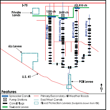
FIGURE 3-7 Simplified map showing Picayune Strand Restoration features.
SOURCE: USACE (2009a).
of the remaining project phases. Installation of 17 culverts (completed in 2006) beneath the Tamiami Trail has restored freshwater flows to coastal systems that had been cut off from their source areas by the highway and its associated canal, but the benefits of the culverts have not been quantified. Within parts of Picayune Strand, the landscape configuration has been returned to more natural configurations by road removal and canal plugs (Figure 3-8), resulting in increased habitat and prey for the Florida panther. SFWMD personnel report that plugging the Prairie Canal has resulted in increased water depths and longer inundation of the terrain extending 1 to 3 miles into neighboring Fakahatchee Strand Preserve
TABLE 3-7 Phases and Progress of the Picayune Strand Project
| Lead Agency | Road Removal | Canals to Be Plugged | Other | Project Phase Status | |
| Prairie Canal | State-expedited project | 65 miles | 7 miles | Remove invasive vegetation, 17 culverts constructed, >13,000 acres of enhancedhabitat | Completed in 2007 |
| Merritt Canal | Federal | 95 miles | 13.5 miles | Remove invasive vegetation; construct Merritt pump station and spreader canal, ~14,000acres of enhanced habitat | Construction began in 2010; anticipated completion in September 2012 |
| Faka Union Canal | Federal | 100 miles | 12 miles | Remove invasive vegetation; construct Faka Union pump station and spreader canal | Construction began in 2011; anticipated completion in 2014 |
| Miller Canal | Federal | 65 miles | 13 miles | Remove invasive vegetation; construct Miller Canal pump station and spreader canal | Anticipated to begin in 2013; to be completed in 2016 |
| Protection Features | Federal | — | — | Flood protection for neighboring developed areas | Anticipated to begin in 2013; to be completed in 2016 |
NOTE: This table contains completion dates that have been updated since the August 2011 IDS was released.
SOURCE: L. Gerry, SFWMD, personal communication, 2011; G. Landers, USACE, personal communication, 2012; USACE (2011a).
State Park (L. Gerry, SFWMD, personal communication, 2011). However, no additional hydrologic analyses or assessments of restoration benefits have been published since the committee’s last report. Ecological monitoring of project-related benefits was initiated after completion of the Prairie Canal Phase and will be expanded as each construction phase is completed (L. Gerry, SFWMD, personal communication, 2012).
Site 1 Impoundment. The Site 1 Impoundment project (also called Fran Reich Preserve; Figure 3-4, No. 2) is located in Palm Beach County south of the Loxahatchee National Wildlife Refuge (LNWR). With an anticipated total cost of $126 million (in 2010 dollars; SFERTF, 2011), the project is designed to reduce seepage and provide water storage to reduce water demands on Lake Okeechobee and LNWR. To accomplish these objectives, the project includes constructing a reservoir with a capacity of 13,300 acre-feet, along with supporting spillways, seepage management features, and a pump station. Phase 1 of the Site 1 Impoundment project (Figure 3-9), which began in October 2010, includes modifications to the existing levee on the northern edge of the impoundment, which are anticipated to reduce seepage from the southern end of LNWR.
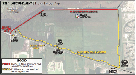
FIGURE 3-9 Phase 1 and 2 project elements of the Site 1 Impoundment.
SOURCE: USACE (2011c).
Phase 1, supported by $44 million in funding from the 2009 American Recovery and Reinvestment Act (ARRA), is anticipated to be completed in FY 2014, and the completion of the impoundment is on hold pending congressional reauthorization of the project necessitated by increased costs and sponsor support (USACE, 2011b; G. Landers, USACE, personal communication, 2012).
Indian River Lagoon-South. The Indian River Lagoon is a diverse biological estuary that includes the mouth of the St. Lucie River where it empties into the Atlantic Ocean on the east side of the Florida Peninsula. Water flows from urban and agricultural areas along with discharge releases from Lake Okeechobee have resulted in declining water quality in the lagoon and its associated habitats. Water managers have experienced difficulty controlling water quantity in the coastal drainages, and some lands have been drained for agricultural purposes, resulting in the loss of freshwater marsh areas. To reverse these trends, the Indian River Lagoon-South restoration project (Figure 3-4, No. 7) includes constructing reservoirs for 130,000 acre-feet of water storage, building four new STAs, and dredging 7.9 million cubic yards of muck to provide a clean channel bed for
the St. Lucie River. These plans are substantially different from those published in the Yellow Book (USACE and SFWMD, 1999), but they represent a broadly based effort to restore water quality to the St. Lucie estuary, along with restored wetland and upland habitats and more natural flow patterns.
As part of the Indian River Lagoon-South project, the SFWMD acquired 20,000 acres of former marsh land in Martin County that had been drained as part of the Allapattah Ranch. The land was purchased to serve as a natural freshwater storage area in the basin. As of early 2012, the SFWMD has filled approximately 17 miles of drainage ditches on about 1,800 acres, and the modifications have resulted in new inundation regimes that have restored more natural hydrologic conditions on about 400 acres of wetlands. To date, vegetative response is limited because rainfall has been less than average in recent years. Additionally, the SFWMD has treated about 15,000 acres to control exotic species such as Brazilian pepper (Schinus terebinthifolius) and Old World climbing fern (Lygodium microphyllum). Overall, the restoration of this wetland area will improve wildlife habitat and provide more natural flows of fresh water to the estuary (L. Gerry, SFWMD, personal communication, 2011).
In November 2011, the USACE began construction on the C-44 reservoir and STA, which are major components of the Indian River Lagoon-South project. The reservoir will provide nearly 51,000 acre-feet of storage to improve the timing of deliveries of basin stormwater to the St. Lucie estuary. The discharged water will be treated by a 6,300-acre STA. The reservoir and STA are anticipated to be completed in 2016 and 2018, respectively (K. Tippett, USACE, personal communication, 2011).
Melaleuca Eradication and Other Exotic Plants. Fifteen invasive plant species pose serious threats to at least some portion of the South Florida ecosystem (Rodgers et al., 2010). Although invasive species management is not a major emphasis of the CERP, the Melaleuca Eradication and Other Exotic Plants CERP project provides support for the battle against invasive and exotic species. The U.S. Department of Agriculture built and operates the Invasive Plant Research Laboratory in Davie, Florida, to rear biological controls specifically to manage the spread of melaleuca, Brazilian pepper, Australian pine (Casuarina equisetifolia), and Old World climbing fern. The CERP provides for the construction of a 2,700 ft2 mass rearing annex “to increase the number of biological control agents needed to effectively manage the four invasive exotic plant species” (USACE and SFWMD, 2010b). With ARRA funding and authorization under programmatic authority for projects totaling less than $25 million, the $2 million construction effort is anticipated to be completed by the end of 2012 (SFERTF, 2011; L. Gerry, SFWMD, personal communication, 2012).
Generation 2 Projects
Generation 2 projects include those that are anticipated to be included in the next WRDA. Because these projects are not yet authorized, they are not eligible to receive federal funding for construction, although in some cases projects have been expedited by the state of Florida. In the past two years, the state has continued construction of two Generation 2 projects: Biscayne Bay Coastal Wetlands and the C-111 Spreader Canal.
Biscayne Bay Coastal Wetlands. The Biscayne Bay Coastal Wetlands are located along the southeastern edge of the Florida Peninsula in the Miami-Dade County area (Figure 3-4, No. 5 and Figure 3-10) where confinement of flows to canals has resulted in loss of freshwater sheet flow in the coastal wetlands and altered salinity in the bay (USGS, 2005). Saltwater wetlands extend over 22,500 acres bordering Biscayne Bay, a unit of the national park system. The project is focused on returning as much as 40 percent of the canal flow in the area to rehydrate up to 11,300 acres of the wetlands with fresh water and to reduce salinity in the near-shore environment of the bay (USACE and SFWMD, 2010a). The total project envisions 13 pump stations, about 20 culverts reconnecting the wetlands, 7 miles of spreader canals, a 1-mile conveyance canal, and plugs for 8,000 feet of ditches at an estimated cost of $185 million (in 2010 dollars; SFERTF, 2011). To expedite project planning and construction, the project was split into two phases, and Phase 1 of the project includes installation of 7 pump stations, 10 culverts, 3 miles of spreader canals, and plugs for 2,500 feet of ditches (Figure 3-4), with the objective of restoring 3,700 acres of wetlands.
Phase 1 has been subdivided into regional project components—the Cutler Wetlands, the L-31 East Flow-way, and the Deering Estates (see Figure 3-10). By 2012, the SFWMD will have completed construction of four new culverts in the L-31 East Flow-way and all of the features in the Deering Estates area (spur canal extension, spreader canal, and pump station) at a construction cost of $5.2 million (excluding planning, engineering, and design costs). The SFWMD has also completed the design for the Cutler Flow-way component of the project and awaits the associated $20.5 million in funding (L. Gerry, SFWMD, personal communication, 2012). The remainder of the project features (including 5 pump stations, an inverted siphon, 6 culverts, 1 mile of spreader canal, and plugs in approximately 1.5 miles of ditches) will be constructed by the federal government at an estimated cost of $25.7 million pending congressional authorization of the project and funding appropriations (A. Saar, USACE, personal communication, 2012). The SFWMD reports, “Although freshwater has flowed into target areas since May 2010, and monitoring is underway, restoration responses have not been measured to date because the past two years have been relatively
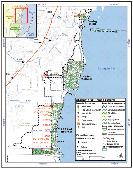
dry and discharges to coastal wetlands have been limited” (L. Gerry, SFWMD, personal communication, 2011).
Phase 1 of the Biscayne Bay Coastal Wetlands is a stand-alone project that is a first step toward achieving the ultimate objectives; other phases will follow but are not yet defined in detail. Phase 1 offers the opportunity for substantial, recognizable progress as well as for learning to improve the design and implementation of subsequent project phases. This approach represents an example of the concept of incremental adaptive restoration (NRC, 2007), and an adaptive management (AM) plan has been developed for the project that ranks the most pressing uncertainties and describes how they can be addressed in the project monitoring plan (USACE and SFWMD, 2010a). Additionally, the AM plan identifies management decision alternatives based on the outcomes of the monitoring.
C-111 Spreader Canal. The C-111 Canal (Figure 3-4, No. 10; Figure 3-11) is the southernmost canal of the entire Central and Southern Florida Project located south of Homestead, and thus it is the “end of the line” in the controlled hydrology of South Florida (USACE and SFWMD, 2011). The C-111 Spreader Canal project seeks to restore sheet flow to area wetlands and restore the quality, quantity, and timing of water flow to estuarine areas. The project has been divided into two phases accompanied by separate PIRs (USACE and SFWMD, 2011) and includes a pilot-scale test project. This approach allows for progress on the western features of the project (PIR 1), while uncertainties about certain design features in the spreader canal features (PIR 2) are being resolved. The western project includes:
• two pump stations (S-199 and S-200);
• a 590-acre detention pond at an agricultural area known as the Frog Pond, which serves to reduce seepage from Taylor Slough;
• extension and modification to the Aerojet Canal, which also serves as a seepage barrier;
• a plug in the L-31E Canal (at S-20A);
• the installation of 10 plugs in the C-110 canal; and
• operational changes at S-18C (Figure 3-5).
By preventing eastward seepage of water from Everglades National Park, the Western Project aims to increase flow volumes in Taylor Slough, thereby restoring coastal salinities in western Florida Bay.
By 2012, the SFWMD will have completed construction of all of the above features in the western project at a cost of $30 million, expediting the project in advance of congressional authorization. If the incremental operational changes
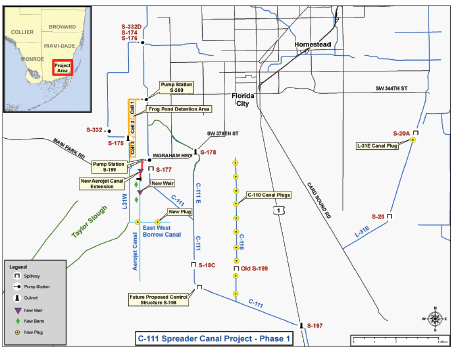
FIGURE 3-11 Project design features for the C-111 Spreader Canal Project.
SOURCE: SFWMD (2012).
at the S-18C structure do not produce the desired increases in Taylor Creek flows, then the federal government may construct an operable structure in the lower C-111 Canal (S-198) at an estimated cost of $5.3 million (2012 estimate) to produce the desired effect. SFWMD personnel expect to see increased amounts of fresh water appearing in Taylor Slough in 2012 as a result of the project, and the Frog Pond detention area should be fully operational by the end of 2012 (L. Gerry, SFWMD, personal communication, 2011; M. Collis, USACE, personal communication, 2012).
Generation 3 Projects
Generation 3 Projects are near-term priorities, but substantial work remains in planning and development of the PIRs. Some of these projects are being expedited with state funding. Of the Generation 3 projects listed in Table 3-1, only the Loxahatchee River Watershed Restoration and Lakeside Ranch STA projects have made substantial construction progress over the past two years.
Loxahatchee River Watershed Restoration. Although the USACE and the SFWMD are still finalizing plans for the Loxahatchee River Watershed Restoration project (formerly the North Palm Beach County project; Figure 3-4, No. 11) and no PIR has yet been drafted, the SFWMD has expedited several components, including the L-8 reservoir, which was intended to reduce high discharges to the Lake Worth Lagoon and enhance hydroperiods in an area known as the Loxahatchee Slough (see NRC, 2008). Currently, the water in the L-8 reservoir contains concentrations of chloride that exceed the Class I 250 mg/L discharge standard, limiting its release into the Grassy Water Preserve (unless diluted). The SFWMD intends to flush the reservoir several times once the full-size pumps are installed (by 2017) to reduce the elevated chloride concentrations, which are suspected to be related to prior mining and rock crushing processes. However, based on the state’s new proposed plan to improve water quality control (described later in this chapter), the state is looking for an alternative storage feature for this project to replace the L-8 reservoir (Meeker, 2012).
One objective of the project is the restoration of the southern headwaters of the Loxahatchee River that begin north of LNWR (WCA-1) and flow north and east to the coast near Jupiter. Area canals have drained several thousand acres of wetland habitat, resulting in saltwater intrusion and periodic desiccation, particularly in Loxahatchee Slough. The SFWMD has installed culverts leading into the slough and established a control structure in the C-18 canal to raise water levels and extend periods of inundation. A more natural hydroperiod has been returned to 5,000 acres of the slough, and SFWMD personnel have observed that on the 5,000 acre tract, invading upland vegetation such as upland pine trees are now receding, replaced with wetland vegetation more similar to pre-drainage conditions (Figure 3-12; L. Gerry, SFWMD, personal communication, 2011, 2012).
Lakeside Ranch STA. The enactment of Florida’s Northern Everglades Initiative in 2007 expanded the Lake Okeechobee Protection Act to the entire northern Everglades system, and identified the Lakeside Ranch STA as an expedited project. The Lakeside Ranch STA involves the construction of a 2,700-acre STA at Lakeside Ranch that will provide approximately 9 to 19 metric tons of
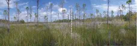
FIGURE 3-12 Upland pine trees on the east side of Loxahatchee Slough that are now stressed, according to SFWMD staff, because of increased water levels after the construction of the G-160 control structure.
SOURCE: L. Gerry, SFWMD, personal communication, 2012.
phosphorus reduction. The STA will be constructed in two phases (STA North and STA South). Phase I includes 925 acres of effective treatment area at a $31M construction cost and was completed in April 2012; Phase II includes 790 acres of effective treatment area at a $42M construction cost (L. Gerry, SFWMD, personal communication, 2012).
Pilot Projects
Pilot projects are important components of the CERP, enabling scientists and engineers to test the capacity of new technologies or approaches and to refine future project design. Although the pilot projects themselves are not expected to lead directly to natural system restoration, the learning that they generate has great value and can be used to improve the design of the full-scale projects. Ultimately, the objective of the pilot projects is to improve the likelihood that the full-scale projects meet their restoration objectives while possibly also making them more cost-effective. Three of the four projects discussed in this section have direct bearing on the planning for Generation 2 or 3 CERP projects.
Aquifer Storage and Recovery Pilot Studies and Regional Study
Aquifer storage and recovery (ASR) was originally conceived as a major water storage component of the CERP, intended to store 1.7 billion gallons per
day in the subsurface during wet periods for use during dry periods. However, concerns existed about high operations and maintenance costs (particularly energy costs), feasible rates of water recovery, and the quality of recovered water and its impact on biota in receiving waters (NRC, 2001, 2010). Out of five original pilot sites to explore these technical and scientific concerns, two 5-million gallons per day (MGD) ASR systems were successfully constructed at the Kissimmee River and Hillsboro Canal.5
The Kissimmee River site has been the most successful to date, where cycle testing6 has been conducted from January 2009 to present. Three cycle tests had been completed as of January 2012, with increasing storage volume and duration for each successive test, and a fourth is under way. Each of the tests achieved 100 percent recovery by volume. Arsenic concentrations in recovered water declined during each cycle test, and during Cycle 4 arsenic concentrations in the recovered water samples were found to comply with the Safe Drinking Water Act (<10 parts per billion (ppb) arsenic). Phosphorus concentrations at the Kissimmee River site also declined during each cycle test from 50 to 120 ppb in surface water to <10 ppb in recovered water samples. However, the UV-disinfection of recharge water has been found to be ineffective during the wet season because of turbidity, suggesting the need for alternative methods of disinfection to meet injection requirements. Cycle testing will end at this site in July 2013.
CERP project staff report that the pilot tests at the Hillsboro Canal site have not been as successful as those at the Kissimmee River site. Cycle testing at this site has been conducted from June 2010 to present, with two tests completed as of January 2012, and the third and final cycle test scheduled for 2012. Saline conditions at the Hillsboro Canal site have resulted in recoveries of only approximately 35 percent in the two cycle tests. Water quality monitoring data at this pilot site are limited, but available data indicate that arsenic is mostly below 10 ppb in the aquifer and recovered water (J. Mireki, USACE, personal communication, 2012).
In addition to the pilot studies described above, a regional groundwater modeling study is being conducted to reduce uncertainties related to regional-scale implementation of ASR in the CERP, a pilot implemented in response to recommendations in NRC (2001, 2002a). A regional groundwater flow and transport model has been developed, calibrated, reviewed, and approved by the Interagency Modeling Center. Preliminary results indicate that the original plan for 333 5-MGD ASR wells in the Upper Floridan aquifer is not feasible
___________________________
5The Floridan aquifer proved to be too sandy for ASR at the Caloosahatchee site, and funding limitations prevented ASR pilot construction at the Port Mayaca and Moore Haven sites.
6Cycle testing involves freshwater injection followed by a rest period and subsequent withdrawal to examine feasible injection and recovery rates, impacts on local groundwater levels, and effects on water quality.
because excessive rise in aquifer heads north of Lake Okeechobee is predicted. Scenarios with 155 wells are currently being simulated. Modeling simulations and analysis will continue through 2012.
Both pilot test and groundwater modeling results suggest that the originally envisioned large-scale application of ASR will not be possible because of anticipated regional effects in the Upper Floridan aquifer and variable site-specific performance affecting the quantity and quality of recovered water. The pilot projects will continue to examine these effects under different implementation scenarios, and a technical data report analyzing the findings of all the ASR pilots and their implications for the CERP is anticipated in late 2013 (J. Mireki, USACE, personal communication, 2012). Considering these preliminary findings, the committee anticipates that ASR could be an effective water storage mechanism at some sites, but in general, CERP planners will need to substantially increase plans for other means of water storage (e.g., dispersed storage, lake storage, reservoirs) to achieve the original water storage objectives of the CERP.
Seepage Management
The CERP contains plans for seepage management projects east of WCA-3 and Everglades National Park to reduce eastward groundwater seepage and flooding of urban and agricultural lands. The CERP L-31N Seepage Management Pilot project (USACE and SFWMD, 2009b) was intended to inform the design of large-scale seepage management solutions for the L-31N levee, on the eastern edge of Everglades National Park. However the pilot project design, which involved bentonite slurry walls at depths of 77-82 ft below ground surface, was estimated to cost more than $16 million, which exceeded the Section 902 limit for the total project cost. As a result the L-31N Seepage Management pilot project has been put on hold.
Meanwhile, the Miami-Dade Limestone Products Association (LPA) independently funded a small-scale seepage study along the L-31N levee during 2009-2011 (MacVicar, Federico & Lamb, 2011a, b). The purpose of this study was to test the feasibility of constructing a larger-scale groundwater seepage control project adjacent to Everglades National Park to mitigate the effects of limestone mining in the Lake Belt region. A 1,000-foot long, 18-foot deep slurry wall was constructed in 2009. Although the slurry wall was found to have an impact on groundwater flow velocities and direction, it did not perform as well as expected in preventing eastward seepage. Tracer studies later showed that the wall leaked, and subsequent analyses identified problems with its installation and design. After additional field and modeling investigations, the LPA determined that these problems could be rectified by changing the cement-bentonite mixture, modifying the construction techniques, enhancing on-site
testing of the integrity of the slurry wall during construction, and deepening the slurry wall to 35 feet to intersect a low-permeability layer (MacVicar, personal communication, 2012). The LPA proposed to conduct an additional pilot 2 miles in length, using these modified techniques, in exchange for wetland-mitigation credits. The Lake Belt mitigation committee approved this proposal in November 2011. Construction of the project began in February 2012 (Figure 3-13), and the project is expected to be completed by July 2012. The system will be monitored to assess its performance.7
The committee applauds the LPA project because it provides a good example of incremental adaptive restoration, by providing tangible increments of restoration while actively working to resolve questions that prevent implementation of the full-scale project (NRC, 2007). The project also offers the potential for substantial seepage management at little to no public cost. If this privately funded 2-mile seepage project is successful, then it could serve as a model for future publicly or privately funded CERP seepage control efforts.
Decomp Physical Model
The Decomp Physical Model (DPM) is a large-scale field experiment intended to inform project planning decisions by reducing uncertainty about the ecological effects of various options for restoring sheet flow to the ridge-and-slough landscape. In NRC (2010), the committee stated that the primary utility of the DPM will be to help to resolve the debate over the need for complete, partial, or no canal backfilling, and secondarily to add new data at an unprecedented level of detail to the existing, substantial body of work on the hydroecological impacts of restoring sheet flow. However, the report questioned whether the before-after-control-impact (BACI) design of the DPM would result in sufficient power to definitively differentiate the canal backfilling alternatives, and whether a clear mechanism existed by which the results of the project will affect decision making with respect to this issue (NRC, 2010).
The DPM study design has been altered very little since the committee’s previous report and remains on schedule. The design includes 10 gated, 60-inch pipe culverts on the L-67A levee, a 3,000-foot gap in the L-67C levee, and three 1,000-foot sections in the adjacent L-67A canal with complete, partial, and no backfilling (USACE and SFWMD, 2010c). The culverts will be managed to create two annual pulse flow events, scheduled for 2012 and 2013, with monitoring from 2010 to 2015. The only change in the project design has been to restrict the pulse-flow events to a narrow November-December window rather than the wider October-January window originally planned to address concerns about
______________________
7See http://www.l31nseepage.org/index.html for additional information.
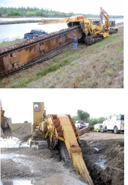
FIGURE 3-13 Trenching begins on the Limestone Products Association’s 2-mile seepage barrier pilot, February 2012.
SOURCE: http://www.l31nseepage.org.
water quality, so that potential impacts are at their minimum (F. Sklar, SFWMD, personal communication, 2011). FDEP subjected the USACE’s application for a permit to construct and operate the DPM to a high level of scrutiny and several requests for additional information but finally granted the permit in January 2012. The extensive permitting process appears to reflect not so much the actual impact of the DPM on water quality but rather the precedent that its permitting sets with respect to water management policy and procedures integrating water quality and water quantity.
C-111 Spreader Canal Design Test
The C-111 Spreader Canal design test was designed to inform future planning of the C-111 Spreader Canal “eastern project,” which will replace existing portions of the lower C-111 Canal with a spreader canal that enhances sheet flow to Florida Bay and restoration efforts within the Southern Glades and Model Lands. The design test was developed to address the following questions (NRC, 2010; USACE, 2012a):
• How would a spreader canal affect surface- and groundwater levels to the north and south of its alignment?
• How much of the source water introduced into the spreader canal will return to C-111 and C-111E via groundwater?
The features of this design test include a 0.5-mile spreader canal, a 0.5-mile pipe to convey water to the spreader canal while keeping the test area separate from groundwater drawdown influences in neighboring canals, and a 50-cfs water discharge rate into the spreader canal (NRC, 2010). The USACE began testing in June 2010, with seven pump tests of increasing pumping duration (ranging from 12 hours to 10 days) and associated surface- and groundwater monitoring at each pumping intake site. The test was completed in August 2011, but the hydrologic data collected for this project have not been analyzed, and no additional progress is expected in the near future because of limited funding. The USACE anticipates that the data will be analyzed once the C-111 Spreader Canal Western Features project is completed and planning of the eastern project gets under way (USACE, 2012a).
NON-CERP RESTORATION IMPLEMENTATION
The aforementioned CERP restoration projects do not stand alone, but rather work in harmony with other non-CERP projects. The progress of the CERP depends upon the successful implementation and effective operation of these non-CERP projects, and three that are particularly important are the Mod Waters project, the restoration of the Kissimmee River, and the state’s Long-term Plan for Achieving Water Quality Goals. This committee has followed the implementation of these projects in its past reports (NRC, 2007, 2008, 2010). Because these projects directly affect the CERP, a brief review of their progress is provided here. Additional details on the progress of these and other non-CERP projects are provided in Appendix B.
Modified Water Deliveries and Tamiami Trail
The Modified Water Deliveries to Everglades National Park project, authorized in 1989, is designed to restore flows into Northeast Shark River Slough that were diminished by the construction of the Tamiami Trail (U.S. Highway Route 41) and the L-29 canal and levee that parallel the highway. The restoration of these flows on a more natural annual schedule will feed much-needed water into Northeast Shark River Slough and return much of its natural function as a central flow-way in the park (SFNRC, 2010; USACE, 2009b). Additionally, the project was intended to improve hydrologic connectivity in WCA-3 by routing more water through WCA-3B. Improved flows were anticipated to offer habitat support for endangered species such as the wood stork, snail kite, Cape Sable seaside sparrow, and Florida panther.
After years of debate over the Mod Waters design, Congress, through the 2009 Omnibus Appropriations Act (P.L. 111-008), directed the USACE to construct a 1-mile bridge in the eastern end of the Tamiami Trail and raise the road to accommodate a canal stage of 8.5 ft—a project increment that is recognized as only a first step toward the originally intended restoration (NRC, 2008). The Act also directed the National Park Service (NPS) to evaluate the science of flows along the Tamiami Trail and to suggest how to improve the flows from a minimum of 1,400 cfs to 4,000 cfs. In its response to this directive, the NPS completed an environmental impact statement (NPS, 2010) and recommended a project alternative that would add 5.5 miles of bridges and raise the roadbed to accommodate a design high-water stage of 9.7 feet. This initiative would restore sheet flow across much of Northeast Shark River Slough, allow substantially higher flow volumes and velocities during wet weather conditions, and improve ecological connectivity between Everglades National Park and WCA-3 when implemented in conjunction with other planned restoration projects. Congress authorized the Next Steps Plan in the Consolidated Appropriations Act of 2012 (December 2011), but the associated $330 million (2010 cost estimate) has not been appropriated. The project would provide the conveyance capacity for flows of up to 4,000 cfs to Everglades National Park and create more natural geomorphology in the slough (NPS, 2010).
At the time of this NRC report, construction is progressing on the 1-mile bridge (Figure 3-14), with completion expected in December 2013. Because the Mod Waters project features are not yet completed, there are insufficient data to assess the restoration benefits of this project. Nevertheless, the project offers an important opportunity for learning about the ecological benefits of flow restoration. Plans allow for a small amount of water to move through WCA-3B, but the full usage of this route for large flows to Northeast Shark River Slough as part of the Mod Waters project are still under review (R. Johnson, NPS, personal communication, 2012).
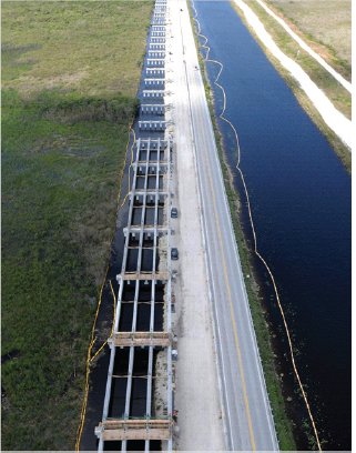
FIGURE 3-14 Construction of the Tamiami Trail 1-mile bridge, December 2011. From left to right, the image shows the north edge of Everglades National Park, the new bridge under construction, the Tamiami Trail (U.S. Highway 41), the L-29 Canal, its levee, and the surface of WCA-3B.
SOURCE: B. Gamble, NPS, personal communication, 2012.
Kissimmee River Restoration
Under the Central and Southern Florida Project, the USACE replaced a sinuous 103-mile stretch of the Kissimmee River with a straight canal about half that length. The installation of control gates created an artificial flow regime, and the project resulted in the drainage of two-thirds of the flood plain (Jackson, 2011), with severe impacts to the wetland vegetation communities that hosted waterfowl, wading birds, and a variety of fishes (USACE and SFWMD, 2009a). Begun in 1999, the joint federal and state project on the Kissimmee River represents an effort to restore the original river and flood plain ecosystem (USACE and SFWMD, 2009a). Both the Kissimmee Headwaters Revitalization Project and the Kissimmee River Restoration Project are anticipated to be completed by 2014 (see Appendix B for more details).
Even though the project is not yet completed, there have been significant gains in measures related to the general goals of the project, such as flood plain inundation, channel flow, organic matter, and dissolved oxygen (Jackson, 2011; see Appendix B). Total phosphorus (TP) in the Kissimmee River remains at elevated levels, however. The partially restored landscape of the Kissimmee River (Figure 3-15) is already hosting increased numbers and densities of important species. Aquatic wading birds have increased in numbers, although their populations are still not large. Long-legged wading birds such as white ibis (Eudocimus albus), great egret (Ardea alba), snowy egret (Egretta thula), and little blue heron (Egretta caerulea) have, in some years, been observed in numbers greater than twice that expected in the restoration (USACE and SFWMD, 2009a). In 2010, investigators found record numbers of wood storks (Mycteria americana) in the restoration area, and bass and sunfish make up an increasing percentage of the fish population (Jackson, 2011). In summary, the Kissimmee River Restoration Project is on track to restore one of the key components of the South Florida ecosystem. This achievement will increase the value of restoration downstream, providing a northern anchor to system-wide restoration.
Long-Term Plan for Achieving Water Quality Goals
As part of its Long-Term Plan for Achieving Water Quality Goals, the state has completed construction of STA Compartments B and C, which have expanded the areas of STA-2 and STA-5/6, adding approximately 11,500 acres of treatment area (Figure 3-16). Both areas were “flow capable” as of December 2010, and vegetation start-up is under way as of 2012. Four of the five planned pump stations are anticipated to be completed by May 2012. Meanwhile, enhancements to maintain or improve the performance of existing STAs continue, such as
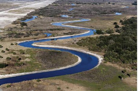
FIGURE 3-15 A restored portion of the Kissimmee River, with the filled C-38 canal in the upper left and the newly re-carved channel of the restored river with an active flood plain on either side.
SOURCE: Jackson (2011), photo by Mark Bias, at http://www.saj.usace.army.mil/Divisions/Everglades/Branches/ProjectExe/Sections/UECKLO/KRR.htm.
addressing hydraulic short-circuiting and converting or reestablishing vegetation as needed (Ivanoff et al., 2012).
In early 2012, the state of Florida announced its plans to develop a water quality treatment plan intended to serve as a means of achieving the state’s water quality legal obligations as an alternative to the approach set forth by the U.S. Environmental Protection Agency (EPA) in its 2010 Amended Determination. On June 4, 2012, the SFWMD outlined the general contours of its alternative plan. In particular, the state has articulated its intent and commitment to construct additional water storage and treatment projects to meet water quality goals. The plan is intended to provide sufficient treatment for the approximately 1.4 million acre-feet/year currently flowing out of the STAs to ensure that water in the Everglades Protection Area meets the legally required water quality standard.
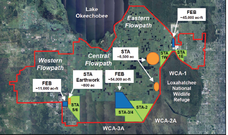
FIGURE 3-16 Location of the Everglades stormwater treatment areas (STAs): STA-1E, STA-1W, STA-2, STA-3/4, and STA-5/6 and the proposed locations for additional STAs, STA earthwork, and flow equalization basins (FEBs) announced on June 4, 2012.
SOURCE: Meeker, 2012.
The state anticipates that it will take approximately 12 years to construct and fully implement its proposed plan, although some features could come online in as soon as four years.
The proposed plan includes enhanced water quality treatment in each of the three flow paths into the Everglades Protection Area: the eastern flow path, the central flow path, and the western flow path (see Figure 3-16). In the eastern flow path, the state-proposed plan calls for the construction of a ~45,000 acre-foot
capacity flow equalization basin to moderate inflows into existing STA-1E and STA-1W in addition to 6,500 acres of new STAs west of LNWR. The plan for the central flow path includes converting the Everglades Agricultural Area A-1 Reservoir footprint (north of existing STA-3/4) into a 54,000 acre-foot capacity flow equalization basin to moderate inflows into STA-3/4 and STA-2. In the western flow path, the proposed plan calls for construction of an ~11,000 acre-foot capacity flow equalization basin and an additional 800 acres of earthwork within existing STA-5/6 to maximize the efficacy of this treatment area. The state’s plan also includes subregional source control measures (including enhanced best management practices) in the EAA, restoration of 15,000 acres of former citrus groves to wetland and upland habitat to reduce the loads on STA-5/6, and construction of a replacement storage feature in the Loxahatchee River Watershed (Meeker, 2012). As noted in Chapter 2, the EPA announced on June 13, 2012 that the state’s plan provides an enforceable framework for ensuring compliance with Everglades water quality standards. The SFWMD Governing Board must still approve the plan.
Although the committee has not been provided with sufficient information to determine whether the plan’s components will achieve a sufficient level of phosphorus reduction to meet legal obligations or restoration goals, the plan appears to be a significant step in the right direction. The plan’s focus on providing significant additional flow equalization and water quality treatment is a significant development with important implications for restoration of both water quality and flow in the central Everglades.
CONCLUSIONS
During the past two years, notable progress has been made in the construction of Everglades restoration projects, with eight CERP projects now under construction. These projects include all of the Generation 1 projects authorized by Congress (Picayune Strand, Site 1 Impoundment, Indian River Lagoon-South, and Melaleuca Eradication) as well as two Generation 2 projects (C-111 Spreader Canal, Biscayne Bay Coastal Wetlands) and two Generation 3 projects (Loxahatchee River Watershed Restoration, Lakeside Ranch STA) constructed solely with state funding. This level of construction, and the associated program funding for 2010-2011, reflect significant implementation progress since the committee’s previous review. Several major project phases are nearing completion in 2012, including the C-111 Spreader Canal Western Project and the Picayune Strand Merritt Canal components, which are expected to deliver significant increments of restoration benefits upon completion. Progress is also being made on important non-CERP projects, including the Kissimmee River Restoration and Mod Waters.
Nevertheless, as noted in previous committee reports, production of natural system restoration benefits within the Water Conservation Areas and Everglades National Park continues to lag behind restoration progress in other portions of the South Florida ecosystem. Early CERP implementation has largely focused on the periphery of the remnant Everglades, and in the most recent CERP project schedule, the projects with the greatest potential benefits to the
remnant Everglades (e.g., decompartmentalization, seepage management, central Everglades storage) have been significantly delayed or remain uncertain.
For project components that have been implemented, the committee was generally unable to obtain rigorous analysis of incremental restoration benefits. In some cases, the only descriptions of progress are anecdotal accounts of vegetation changes or field observations of new water flows. Effective assessment of restoration progress will depend on monitoring data that cover periods long enough to establish pre-project trends, followed by similar data after the project (or project component) is complete to determine the ecological changes that can be ascribed to the project. Such a scientifically derived assessment of ecosystem response to project implementation is important to enhance the understanding of ecosystem recovery processes and may be useful to build public support for ongoing restoration efforts.
The Central Everglades Planning Project provides a means to expedite the realization of restoration benefits to the remnant Everglades while addressing major impediments inherent in the USACE project planning and approval process. The Central Everglades Planning Project is one of five USACE pilot projects nationwide that will test a new accelerated project planning process, with the goal of delivering an approved project implementation report to Congress within two years. The focus on the central Everglades (Water Conservation Area 3 and Everglades National Park) is appropriate for this pilot, given the urgent need to address ongoing ecosystem decline, as noted in NRC (2008). The Central Everglades Planning Project process allows for the combination of increments of multiple CERP projects (e.g., storage, seepage management, decompartmentalization) within a new planning framework to more easily identify their interdependence and system benefits. The pilot also intends to test new approaches for project planning, including clear, early scoping of analyses and decision-making criteria, early coordination with decision makers at all levels of USACE leadership, and reduced reliance on detailed analyses within a framework of risk-based decision making. The Central Everglades Planning Project appears to be an important step forward, responsive to earlier concerns of this committee (NRC, 2007, 2008, 2010), and consistent with the concept of incremental adaptive restoration (NRC, 2007). However, at completion of this report, the process remained at an early stage, and no specific project plans were available for the committee to review.
State-proposed projects to improve water quality represent an important step forward, with critical implications for restoration of attributes in the central Everglades impacted by high levels of phosphorus. Additional progress toward meeting water quality criteria appears likely, because the state and the federal partners have recently agreed upon additional water quality improvements for the Everglades Protection Area. These proposed features, however,
address only current inflows to the Everglades, and do not provide water quality treatment for increased water volumes anticipated under the CERP.
If the pace of restoration progress is to be maintained, then an increased level of federal funding will be necessary for two reasons. First, large cuts to the SFWMD budget have already led to deferral of several large projects, and relatively modest outlays are projected over the next five years, mostly for water quality improvements to attain compliance with water quality criteria. Projected funding relies heavily on a drawdown of reserve funds to levels that, without other changes, will leave the SFWMD with little flexibility and limited capability to fund new CERP projects. Second, overall state CERP spending (including land purchases and expedited construction efforts) has vastly exceeded federal spending. Thus, even if the state could sustain prior levels of spending, the SFWMD might be reluctant to do so until the overall spending gap is reduced between the two partners. Nevertheless, the capacity for increased federal spending could be impacted by CERP cost-sharing requirements, because calculations of the cost-share balance do not include extensive state expenditures from land purchases and construction for projects that are not yet authorized.
Without congressional action, project authorization could soon become a major impediment to restoration progress. To receive federal funding, individual CERP projects must be authorized by Congress. To date, only three projects have been congressionally authorized under WRDA 2007, and one additional project is under construction with programmatic authorization from WRDA 2000. Four additional projects await authorization. Without a new WRDA, the federal government will be unable to maintain progress on several second-generation, state-expedited projects now under way (e.g., C-111 Spreader Canal, Biscayne Bay Coastal Wetlands). Also, authorizations affect the projects that are eligible for cost-share crediting. With no additional authorized projects and at current rates of federal spending, the federal creditable expenditures could exceed the state’s in approximately three years, bringing the CERP to a standstill because federal cost-share creditable obligations may not exceed those of the state. If Congress does not authorize additional projects and the state does not increase spending, federal funding and project implementation would need to be sharply curtailed. Additional project authorizations (with accompanying project partnership agreements) could allow for more than $500 million of state CERP-related expenditures being credited as cost-shared funds.
Innovative, multi-species approaches have been applied to resolve local conflicts between species management and restoration management, but such conflicts are likely to continue, requiring flexible and innovative multi-species approaches applied at even larger spatial scales to avoid restoration delays and optimize restoration benefits. Examples of innovative multi-species approaches include the Everglades Restoration Transition Plan (ERTP) to address a conflict
between the water management needs of endangered snail kites and Cape Sable seaside sparrows in Water Conservation Area (WCA)-3A and an approach to address a conflict between stormwater treatment area (STA) operations and protection of the nests of black-necked stilts and other migratory birds. Additional conflicts between the needs of endangered species and what is required to restore the ecosystem restoration are inevitable in the transition to a fully implemented CERP. A recent conflict between efforts to protect snail kite nests and STA operations illustrates how single species management could potentially compromise water management required for system restoration.


