
2
Prioritize Core Capabilities
The entire weather, water, and climate enterprise is built on a foundation anchored by the core capabilities of the National Weather Service (NWS). These core capabilities include foundational datasets, essential functions, and operationally related research. Prioritization will allow the NWS to focus time and resources on those things it does best and are most needed. This chapter provides details and sub-recommendations in support of Recommendation I and as guidance to the NWS as it attempts to prioritize its core capabilities. Above all, the Committee feels that clear performance metrics and evaluation of the impact of scientific and technological advances on those performance metrics will best guide the NWS in prioritizing its investments.
Recommendation I: Prioritize Core Capabilities
The National Weather Service (NWS) should
1. Evaluate all aspects of its work that contribute to its foundational datasets, with the explicit goal of ensuring that those foundational datasets are of the highest quality and that improvements are driven by user needs and scientific advances. As part of this initial and ongoing evaluation effort, clear quality and performance metrics should be established. Such metrics would address the technical components of NWS operations, as well as the efficiency and effectiveness of the flow of weather information to end users.
2. Ensure that a similarly high priority is given to (a) product generation and dissemination, (b) the brokering and provision of data services, and (c) development and enhancement of analysis tools for maintaining a common operating picture (COP).
3. Engage the entire enterprise to develop and implement a national strategy for a systematic approach to research-to-operations and operations-to-research.
Foundational datasets include collected and integrated observations, advanced analyses either from modern data assimilation or other objective methods, and predictions obtained from deterministic and probabilistic models. As indicated in the first bullet of Recommendation I, evaluation of the NWS’s foundational datasets with the goal of improving their quality will necessitate unambiguous quality and performance metrics. These would include existing metrics such as probability of detection and lead time for severe weather (e.g., tornadoes, flash floods), hurricane track and intensity forecast skill, quantitative precipitation forecast skill, and hydrologic prediction forecast skill. For numerical weather prediction, such metrics include the traditional comparison of model performance at the 500 hPa level. Evaluation of these models will need to expand to include surface-level performance as well. False alarm ratios are currently included for most severe weather events, but the strict definition of this metric will need to be reevaluated to expand its usefulness. Finally, as the NWS moves away from deterministic forecasts toward probabilistic forecasts, metrics will need to move toward more appropriate measures of performance, such as reliability, calibration,
and sharpness. The NWS will also need to develop a systematic method for evaluating the effectiveness of communicating warnings to the public.
Maintaining Infrastructure Through Technology Infusion
Keeping up with advances in technology requires a continual NWS program of technology infusion. Areas to be covered by such a program include major communications and processing systems, satellites and ground processing, and ground-based radar, sensor, and gauge networks.
In each of these areas, a well-organized program of technology infusion would provide a means for the NWS to avoid becoming obsolete and requiring another massive overhaul like the MAR. This is consistent with Lesson 1 of NRC (2012a). Lesson 2 of that report found that such a technology program requires established systems engineering processes, including setting system-level requirements and performance metrics for evaluating progress toward meeting those requirements. The capability for development and testing, and a process for rapid field-testing of prototype systems, would also be an important part of the program and is discussed in further detail later in this chapter.
In the computing area, five-year-old hardware is obsolete in today’s world of rapidly advancing technology. Thus, planning and budgeting for replacement needs to begin as soon as a new generation has been deployed, if not sooner. For example, during the MAR, the information technology (IT) systems for both the Advanced Weather Interactive Processing System (AWIPS) and Next Generation Weather Radar (NEXRAD) were upgraded, in some cases before the systems were fully commissioned. These upgrades were developed through prototyping and involved interaction with the research community and the contractor. The AWIPS-II program is an example of a computing upgrade that addresses the need for systems refreshment. However, AWIPS-II is also an example of a failure to draw upon what was learned during the development and deployment of the major systems of the MAR. Rather than making continual upgrades, all upgrades were stopped almost ten years ago in anticipation of the large AWIPS-II upgrade. An example of success in the area of computing technology has been the leasing of research and operational high-performance computing assets. Leasing allows for more rapid updating of computing infrastructure and prevents the procurement of out-of-date technology.
The NWS is only one part of NOAA that feeds requirements to, and utilizes data from, the NOAA satellite systems. Therefore, processes for technology infusion related to the satellite programs need to involve NOAA management, NESDIS, and other branches, along with the NWS. It is also important to note that a “satellite system” typically consists of multiple segments, or elements, including space vehicle; instruments; launch vehicle; command, control, and communications (C3); and data processing hardware and software. Costs for each of these elements can be substantial, as can costs for development of the science versions of the data processing algorithms and program management. (These last two elements can include a large portion of government personnel.) Each of the system elements alone can be quite complex and therefore costly. These disparate elements of the system need to be specified, acquired, built, and activated synergistically as they work together to provide data and products. Exercising a well-established systems engineering process is therefore critical both for existing data observation and product continuity and for planned technology infusion.
NOAA has a relatively well-established approach to the acquisition of its satellite system elements that typically includes a process for developing instrument requirements, study and risk reduction phases involving preliminary designs, and possibly early component-builds from competitors.1 These phases of the program include both space and ground segment elements that apply to spacecraft, instruments, ground algorithms, and processing. NOAA also typically requests detailed
____________
1 This assessment applies primarily to NOAA’s Geostationary Operational Environmental Satellite (GOES) and Polar Operational Environmental Satellite (POES) series. As noted in the Committee’s first report, the National Polar-orbiting Operational Environmental Satellite System (NPOESS) program, while following a similar procurement process, was not managed directly by NOAA but by a tri-agency Integrated Program Office, of which NOAA was a member (GAO, 1995). NOAA, the NWS, the other agencies involved, and the enterprise as a whole have been affected by the issues encountered by the NPOESS procurement approach. The full range of lessons to be learned from that approach is beyond the scope of this report.
life-cycle cost estimates for elements of various system architectures. With these standard procurement processes, the government can obtain a “rack and stack” of an assortment of sizes and designs of spacecraft, instrument designs, and data processing approaches—with the associated cost, risk, performance, and schedule metrics. With respect to data products, NOAA has, on various programs, endeavored to group the products into categories that indicate a prioritization. These techniques all show recognition of the importance of the systems engineering process, including top-level requirements development.
Infusion of new technology into the NOAA satellite programs requires an even more rigorous approach to developing a clearly defined and recognized process. At the least, because the satellite system elements can be so costly and time-consuming, each planned infusion of new technology requires metrics that illustrate the potential benefit. NOAA has at times included in the requirement set “pre-planned improvements” grouped in a lower-priority category. This is a good way to encourage competitors to strive for new approaches in design while keeping the primary focus on higher-priority requirements.
It would serve NOAA to make the connection between specific products and metrics that illustrate the importance of these products even more clear. The products are linked to observations and thus instrument and other element designs as well as processing algorithms. Although the trade-offs needed to develop some of these metrics can be difficult and costly, they can be useful for directing resources most efficiently and potentially eliminating some less-critical observations. As an example, methods for determining impacts of various measurements on numerical weather prediction are described later in this chapter. NOAA provided a good visual example of impact metrics when it compared the “Snowmageddon” weather forecast with and without the polar afternoon orbit satellite data (Sullivan, 2011). In this case, however, no distinction was made as to which instruments on the polar platform made the most critical difference. A further level of detail would be needed to adequately prioritize among instruments or instrument designs.
Another very important distinction to be made in technology infusion (and indeed in general product prioritization) is between the operational mission and products and research mission and products. Both aspects are critical to NOAA and to the nation. But the distinction needs to be made very clearly. An operational mission and the observations required to accomplish that mission are presumably thus identified because of their very criticality to the nation and its more immediate security and well-being. A well-planned research program and the associated requirements and products serve a different purpose; indeed, it is the cornerstone of technology improvement and infusion. Operations and research are synergistic, but the goals and metrics of each need to be clearly stated and differentiated. NOAA’s current approach is to include a select group of lower-priority “product improvement” requirements along with the higher-priority product requirements. Although this allows for some research infusion, perhaps a clearer distinction needs to be made, if possible, with a separate, well-recognized national approach to research satellite missions that feed specifically into NOAA operational missions. In this way, there is a synergistic process yet a clear distinction between missions.
This has been a part of the process in prior years: an example is the Operational Satellite Improvement Program (OSIP), a NOAA-National Aeronautics and Space Administration (NASA) agreement in effect from 1973 to 1981, in which the results from the NASA research missions were fed into requirements development for the NOAA operational missions (GAO, 1997). It should also be noted that part of the original intent of the National Polar-orbiting Operational Environmental Satellite System (NPOESS) Preparatory Project (NPP) was to facilitate risk reduction for NPOESS in areas including sensors, algorithms, and ground processing. NPP was not intended to be an operational mission itself. NOAA, along with the other members of the tri-agency NPOESS Integrated Program Office, embraced this approach.
In the area of radar observations, the just-being-completed NEXRAD polarimetric upgrade is bringing new and valuable capabilities to the field. At the same time, the basic NEXRAD design is nearly 25 years old, and the other major apparatus (apart from data and signal processing equipment) is more than 15 years old. Given the long development, design, procurement, and deployment cycle for such a large system, as well as the need for multiagency requirements development and
approval, the time is already here to plan for the next generation of radar surveillance equipment.
Various avenues are open. The simplest and perhaps least costly option (at least in the short run) would be a Service Life Extension Program (SLEP). Assuming regular replacement and upgrading of signal and data processing facilities and data display equipment, the major NEXRAD components that would need SLEP attention are electromechanical—such things as motors, gears, and bearings. A second, more expensive, option would involve wholesale replacement of the NEXRAD radars with new equipment of similar design. A third option is to collaborate with the Federal Aviation Administration (FAA) (and perhaps other agencies) in the development and deployment of a multifunction surveillance radar system. Work toward that goal is ongoing, with emphasis on phased array radar (PAR) technology. At this point, however, the ability of a PAR system to provide NEXRAD-like polarimetric capabilities has not been established. Moreover, the likely procurement and life-cycle costs of such a system are not yet known. Another potential obstacle lies in the frequency allocations required for such a PAR system. According to current design concepts, the bandwidth required is substantially greater than that of the NEXRAD system, but there is already great pressure to dedicate more of the S-band spectrum to communications applications.
Any of the preceding options leaves unresolved the issue of comprehensive low-level coverage. Good low-level coverage is important for many severe-storm warning and precipitation-estimation applications as well as in complex-terrain situations. Dealing with such issues would require radars that are more closely spaced, particularly in regions of mountainous terrain, which would have to be more numerous than the NEXRAD radars but could be smaller and less expensive (because of the overlapping coverage). Here the Collaborative Adaptive Sensing of the Atmosphere (CASA) experience demonstrates much of the needed capability (McLaughlin et al., 2009). Here again, however, the procurement, deployment, and life-cycle costs of a practical system are not yet known. It may well be that benefit-cost considerations would favor a hybrid system, including a mix of NEXRAD-like surveillance capabilities with smaller local networks of CASA-like radars to deal with areas where the NEXRAD coverage is insufficient, such as urban areas or mountainous regions.
In addition to hardware platforms, the NWS will also need to address technique and algorithm development, which will be critical to maximizing the use of radar data. In the past, the development and evolution of data processing algorithms has been done in collaboration with the National Severe Storms Laboratory (NSSL), the Department of Defense (DOD), and the FAA. In order to avoid a large and expensive upgrade, as noted in Lesson 1 of the Committee’s first report, incremental, collaborative advances in data algorithms will need to continue.
For surface observations, the NWS currently relies on the joint NWS/FAA Automated Surface Observing System (ASOS) network. As noted in this Committee’s first report, the ASOS network was designed primarily to support aviation needs. Because of issues with ASOS sensor performance many scientists have developed their own networks for surface observing needs (NRC, 2012a). It has become commonplace that surface observations from private or public mesoscale networks (mesonets) are utilized in conjunction with, or instead of, data from ASOS. Mesonets have proven to be far more agile in terms of evolving sensor suites than has the ASOS network. The sensor suite and the spatial and temporal resolution of ASOS data have seen little improvement since the end of the MAR. Despite the relative maturity of surface observing technology, critical gaps remain. Land-surface properties important to numerical weather prediction, particularly soil moisture, lack the necessary spatial resolution (NRC, 2009). Urban areas, mountains, and coastal zones all present unique observing and forecasting challenges. A recent NRC report addressed the unique needs of the urban environment (NRC, 2012b). As the NWS expands the range of users it serves under the Weather-Ready Nation paradigm, it will be necessary to consider whether the surface observation data collected by the ASOS network is sufficient to meet user needs or whether other surface observing systems would provide the needed agility.
Similar challenges exist with respect to hydrologic observation and forecasting activities. Presently, the observational infrastructure for hydrologic forecasting is fragmented across such different agencies as the U.S. Geological Survey (USGS), the Natural Resources Conservation Service, NASA, and the NWS, in addi-
tion to various state and regional entities. The lack of standards between these networks combined with nonuniform acquisition quality control standards for merging these datasets translates into significant probability that use of existing observations is suboptimal. Such new technologies as multi-scale estimates of soil moisture or skin temperature or satellite altimetry of river and reservoir levels are not easily or readily being integrated into the existing data assimilation and forecasting workflows. Finally, a preliminary plan was presented to the Committee on how to address these issues, though these topics were raised in discussion related to the development of the new National Water Center being constructed in Tuscaloosa, Alabama. A thorough, integrated assessment of observational, data assimilation, and data management needs for hydrologic prediction activities would provide much-needed guidance to address current challenges in developing and adopting the hydrologic prediction components of the NWS (these challenges are elaborated on in Chapter 3).
Recommendation I.a
The National Weather Service (NWS) should continue technology infusion programs that have been effective subsequent to the Modernization and Associated Restructuring. Parallel support from the National Environmental Satellite, Data, and Information Service (NESDIS) is needed to provide continuing upgrade of satellite capabilities. Such infusion programs should include both hardware and software development.
Numerical Weather Prediction
Numerical weather prediction guidance affects nearly every facet of the NWS’s mission. The NOAA Global Forecast System (GFS)2 is one of the centerpieces of the NWS modeling enterprise. Not only is the GFS a key model used for short- and medium-range forecasting, it is also used to initialize or provide boundary conditions for many downstream models, applications, and products. Those include the North American Mesoscale Model (NAM)3; the Wave Watch III wave model4; the global Real Time Ocean Forecast System (RTOFS)5 (based on the Hybrid Coordinate Ocean Model [HYCOM]6); hurricane models (Hurricane Weather Research and Forecasting [HWRF]7, Geophysical Fluid Dynamics Laboratory [GFDL]8); air quality applications and models (Hybrid Single Particle Lagrangian Integrated Trajectory [HYSPLIT]9); aviation applications; and many specialized products. The numerical model used by the medium-range ensemble system is the GFS. Additionally, the GFS code and development are closely linked with the Climate Forecast System (CFS). It follows that the performance of the GFS has a crucial impact on many downstream models and products.
Performance in numerical weather prediction at the National Centers for Environmental Prediction (NCEP), including medium-range modeling, has been steadily improving and NCEP is widely considered one of the world leaders in weather and climate prediction. However, global forecast models run by several other national centers consistently outperform NCEP by established metrics of numerical modeling skill. The performance of the GFS was partially addressed in the Committee’s first report (Finding 4-4) and is discussed in more detail in this section.
One method to assess the performance of the NWS global medium-range forecast model is to compare its accuracy to that of model-based forecasts made by other operational weather centers of the state of the atmosphere at approximately 18,000 ft (500 hPa). This metric is often considered the gold standard for medium-range prediction models because the 18,000-ft level is a dynamically significant region near the vertical midpoint of the troposphere that contains signatures of weather systems from the surface up through the jet stream aloft. Thus, this integrative metric is widely used for evaluation of the overall model performance. Many centers have a long history of this metric that tracks the model performance and improvements over the years, and this is one of the WMO standard statistics for model inter-comparisons. Weather prediction
____________
2 http://www.srh.noaa.gov/ssd/nwpmodel/html/gfs.htm
3 http://www.srh.noaa.gov/ssd/nwpmodel/html/nam.htm
4 http://polar.ncep.noaa.gov/waves/index2.shtml
5 http://polar.ncep.noaa.gov/ofs/
7 http://www.emc.ncep.noaa.gov/index.php?branch=HWRF
centers evaluate many other metrics as well (such as precipitation, low-level winds, tropical cyclone tracks and intensity, and surface pressure).
Figure 2.1 compares the 5-day forecast performance of several operational centers, including the NCEP GFS, for the time period 1996 through the present, averaged over the Northern and Southern Hemispheres. The leading models, including the GFS, have exhibited steadily increasing skill over the past 15 years. However, the European Centre for Medium-range Weather Forecasts (ECMWF) and more recently the UK Meteorological Office (UKMO) consistently outperform the GFS (and all other operational global medium-range forecast models). Additionally, it is apparent that the GFS has not closed the gap in terms of forecast skill with ECMWF over the past decade or more. Environment Canada and Japan have also shown significantly positive trends in predictive skill over the past decade.
Systematic comparison using metrics other than overall accuracy at 500 hPa, particularly at the surface, is more limited. However, the conclusions are similar. Wedam et al. (2009) compared surface forecasts of sea level pressure along the East and West Coasts of the United States during the winters of 2005 through 2008. On average, the NCEP errors were 26 percent greater than those of the ECMWF. Froude et al. (2007) and Froude (2010) compared the performance of the NCEP and ECMWF ensemble forecasts in forecasting extratropical cyclones in the Northern Hemisphere. Again, the ECMWF consistently produced better forecasts than did NCEP.
The Committee believes that a dedicated, community R2O effort, based on lessons from other centers, would aid the NWS in improving its numerical weather prediction skill (for example, the efforts of the Navy as described later in this chapter). Additionally, the UKMO and ECMWF systems have more advanced data assimilation systems than the current NWS GFS has, which may partially explain some of the differences in the performance of the systems. For example, both the UKMO and the ECMWF make use of an advanced data assimilation method, namely, four-dimensional variational (4DVar) assimilation. And both the UKMO and the ECMWF have made various improvements to their 4DVar systems, including recent advances to achieve a hybrid assimilation
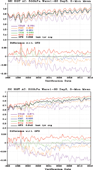
FIGURE 2.1 Five-day forecast 500 hPa anomaly correlation (top panels) for different forecast models (NCEP’s Global Forecast System [GFS], European Center for Medium-range Weather Forecasting [ECM in figure legend], UK Meteorological Office [UKM in figure legend], Fleet Numerical Meteorology and Oceanography Center [FNO], the baseline Coordinated Data Analysis System [CDAS], and Canadian Meteorological Centre [CMC]) from 1996 to 2012 for the Northern (top) and Southern (bottom) Hemispheres. A higher anomaly correlation indicates better model forecast performance. The differences with respect to the GFS system are shown along the bottom panels, with positive values indicative of higher forecast skill than the GFS. SOURCE: National Centers for Environmental Prediction.
capability using synergistic variational and ensemble approaches. Recently, NCEP has also pursued a hybrid data assimilation approach and implemented a major upgrade in May 2012 to their three-dimensional variational (3DVar) system using a hybrid approach, which is intended to improve the overall performance (Lapenta, W., NWS Environmental Modeling Center, personal communication to member of the Committee). However, NCEP can further improve the GFS through implementing existing data assimilation technology, such as 4DVar, that is already being used at other leading centers.
Given the central role of the NCEP GFS, improvements made to its skill translate to improved products and performance in downstream models. An example of the relationship between the GFS performance and a downstream model is seen in the performance of the HWRF modeling system. It is estimated that the forthcoming improved hybrid (3DVar/ensemble) data assimilation system in GFS alone will lead to a significant improvement in the track prediction skill of the HWRF, based on a large sample of cases from the past several years (Tallapragada, V., NWS Environmental Modeling Center, personal communication to member of the Committee).
Another major difference between the leading operational center modeling systems and the GFS is the horizontal resolution in the models. The ECMWF uses a horizontal resolution of 17 km, while the GFS uses 27 km. Increases in resolution need to remain a high priority not only for the GFS but for downstream models as well.
Trade-offs might be considered between the number of numerical models being currently run by NCEP, the frequency with which these models are run, and the horizontal resolution in the models. Fewer models (either through consolidation or replacement with unified models that can address multiple scales and applications) being executed less frequently (within requirement limits) would allow for higher resolution to be achieved, as well as more sophisticated data assimilation and physical parameterization approaches to be used. Furthermore, within the NWS the concept of a unified modeling system—a single model for local, regional, global, and climate scales, which has been embraced by the UKMO—needs to be considered. Such a system minimizes duplicative developmental and software infrastructure efforts that are needed to maintain multiple numerical modeling systems. A new generation of numerical techniques and dynamical cores that are sufficiently flexible to address the multiple needs of the NWS ranging from high-resolution limited areas to global weather and climate applications are rapidly maturing and becoming available, suggesting the time is right to consider such a unified model approach. The use of cloud computing technology could help the NWS acquire computational flexibility to address changing priorities, and possibly reduce computing costs.
New community efforts are now emerging that will attempt to unify research and operational prediction systems and capabilities across a number of U.S. agencies. An inclusive and holistic approach (uniting nations, agencies, and disciplines) to Earth system science and numerical prediction is essential to realize much-needed major advances in observations, analysis, data assimilation, and prediction of high-impact weather and climate (Brunet et al., 2010; Shapiro et al., 2010; Shukla et al., 2009, 2010). Some of the challenges include infrastructure issues related to national computational resources, especially operational computing capacity, required for high-resolution weather and climate forecasting; the importance of collaboration between the weather and climate research communities for advances in seamless prediction; and improved end-user products produced by forecast systems. The Earth System Prediction Capability (ESPC) represents the national response to this need and many challenges. The International Council for Science (ICSU) and international partners, including the Belmont Forum of funding agencies (the National Science Foundation is a lead member), have developed a new international initiative—Future Earth: Research for Global Sustainability—and this demonstrates the importance of linking improved predictions of weather and climate with a broad range of societal issues such as food, water, energy, health, and human security.
The Committee notes that improving NWS’s numerical weather prediction capabilities will require a systematic approach to transitioning research to operations. In designing such an approach, useful lessons can be drawn from the success of the R2O systems of the Navy and ECMWF programs.
Recommendation I.b
The National Weather Service (NWS) global and regional numerical weather prediction systems should be of the highest quality and accuracy, with improvements driven by user needs and scientific advances. To achieve this goal, the NWS should give priority to upgrading its data assimilation system and increasing the resolution of its deterministic and ensemble modeling systems. The product development process can be improved by developing a systematic approach for research-to-operations through collaboration with users and partners in the entire weather, water, and climate enterprise, both in the United States and around the world.
Current and Future Observing Needs for
Numerical Weather Prediction Models
To better anticipate future observing needs and requirements, it is beneficial to consider the impact of the various current generation observation types on numerical weather forecasts. Furthermore, analysis of the relative value of observation systems can be useful for prioritizing investments. A plethora of surface, aircraft, radiosonde, satellite, and radar observations are used to initialize numerical weather prediction models. The impacts of these observations on numerical weather forecasts have been quantified traditionally through observing system experiments (OSEs), in which observations are removed from (or added to) a data assimilation system and the resulting forecasts are compared to a control set of forecasts. Such OSEs can provide an indication of a gross impact of observations on forecasts. However, OSEs are expensive because of the number of experiments required to test the large number of observation types, including such things as multiple individual sensing channels on satellite sounding instruments.
New approaches have recently been developed based on adjoint10 sensitivities through the linking of the adjoint for the data assimilation and modeling systems (Langland, R.H., and N.L. Baker, Naval Research Laboratory, and Gelaro, R., NASA, personal communication to member of the Committee; Errico, 2007; Gelaro et al., 2007). These methods can provide detailed information about the impact of various observations and can help to identify problems with any given observation or the way that observation is assimilated. One caveat is that the estimate is subject to assumptions and limitations inherent in the use of adjoint models (i.e., the so-called tangent linear assumption). The adjoint observation impact method can quantify information related to the observation type and location. Similar observation impact information can be obtained from ensemble-based approaches as well.
In the last decade, adjoints for the modeling and data assimilation systems have been developed and applied at many centers around the world, including NASA, the U.S. Navy, ECMWF, UKMO, Meteo-France, and Environment Canada. NCEP has closely collaborated with NASA to develop an adjoint for the data assimilation systems because they share similar data assimilation methodology. However, it would be useful for the NWS to develop an adjoint for the prediction systems as well, such as the GFS, to enhance the monitoring and guidance of the impact of observations on their own Numerical Weather Prediction (NWP) systems (and downstream forecast systems). The observation impact tool can be especially valuable for the evaluation of hyper-spectral satellite sounders (with thousands of channels) since the methodology provides quantitative guidance on the selection of which channels to assimilate (given one only has sufficient resources to assimilate a fraction of them).
An example of the daily average observation impacts for January 2007 is shown in Figure 2.2. The results compare the observation impact on analysis and prediction systems from the NASA (GEOS-5), U.S. Navy (NOGAPS), and the ECMWF (EC-MSGFS) operational systems. The Advanced Microwave Sounding Unit (AMSU-A), radiosondes, satellite winds, and aircraft observations all have the largest impact in all of the systems for 24-hour forecasts using a synoptic-scale metric.
One can also compare the impact per observation that reduces the forecast error. On a per observation basis, some of the surface observations such as ships and land surface data become more important.
____________
10 The adjoint—the transpose of the forecast model’s forward tangent propagator—provides a particular forecast output’s sensitivity to initial state changes in a mathematically rigorous and computationally feasible manner.
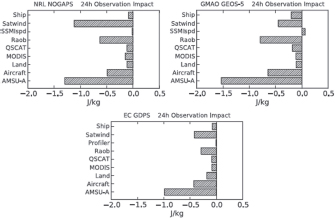
FIGURE 2.2 Daily average impacts of various observation types on 24-hour forecasts from January 2007 in U.S. Navy NOGAPS (top left), NASA GEOS-5 (top right), and ECMWF GDPS (bottom left). The results are presented as an energy-based measure of forecast error, and the units are J kg-1. Larger negative numbers imply that the observation types are reducing the forecast error. The observation types include ships and buoys (Ship), geostationary satellite winds (Satwind), radiosondes and dropsondes (Raob), QuikSCAT winds (QSCAT), MODIS satellite winds (MODIS), land surface-pressure observations (Land), commercial aircraft (Aircraft), and AMSU-A radiances (AMSU-A). Results are also shown for SSM/I wind speeds (SSMIspd) in NOGAPS and GEOS-5 as opposed to profiler winds (Profiler) in GDPS, but both those observations types have the smaller overall impact in the respective forecast systems. In all systems, the AMSU-A, radiosondes, satellite winds, and aircraft observations have the largest impact on the forecast. SOURCE: Gelaro et al. (2010). ©American Meteorological Society. Reprinted with permission.
The impact of individual satellite channels can be assessed as well.
Several key aspects are emerging from these studies that are important for the future directions of observing systems used for NWP models. The radiosondes are still important, and degradation to the global radiosonde network could be detrimental to synoptic-scale and mesoscale forecasts. There are large differences in NWP analyses where models assimilate radiances from satellite sensors; the differences are small where they assimilate radiosonde data (Langland, R.H., and N.L. Baker, Naval Research Laboratory, personal communication to member of the Committee). While radiosondes are essential and necessary to anchor the satellite observing systems, the number of daily radiosonde observations has decreased during the same time period that the skill of global forecast models has increased. Further analysis is needed to determine how many radiosondes are needed and how they can be optimally distributed. The results of such an analysis could differ based on whether the goal is improving the skill of regional or global forecasts.
Radiosondes provide direct measurements of temperature, moisture, and winds, in contrast to satellites that typically provide vertically layered radiance information that is often more difficult to assimilate. NWP models likely suffer from a lack of accurate wind data, particularly in the troposphere. Cloud track winds are typically one of the most important satellite observations for NWP models; however, their positive impact may be mitigated by inaccurate estimates of cloud height assignments. Radiances are now available from sensors on several different satellites (AMSU-A, IASI, AIRS) and the data may currently be somewhat redundant from a modeling perspective (but may not be in the future as some key satellites expire). Although NWP models are thought to be especially sensitive to moisture observations, these observations are often more limited and very difficult to use. For example, water vapor channels from satellite infrared sounders are quite challenging to use in current data assimilation systems.
One major caveat is that most of these data impact studies have been made with medium-range prediction models, and the results may not necessarily translate
to the mesoscale and high-impact severe weather. Moisture and boundary layer wind field observations are likely to be even more important on the mesoscale.
Accurate tropospheric wind measurement is considered one of the highest observation priorities to improve weather prediction and climate (Hays et al., 2005). One critical future observing system is satellite LIDAR (LIght Detection and Ranging); LIDAR-derived winds would fulfill a vital national need for high-resolution global tropospheric wind observation and will lead to improved long-range weather forecasting and more accurate hurricane landfall prediction (e.g., Baker et al., 1995; Hays et al., 2005). Currently available radiosonde wind measurements are sparse. The Atmospheric Dynamics Mission (ADM-Aeolus) of the European Space Agency (Stoffelen et al., 2005), set to be launched in 2013, will provide global observations of vertical wind profiles with the aim of demonstrating improvement in atmospheric wind analyses for NWP and climate studies.
Adaptive or targeted observations have been explored for applications such as tropical cyclones (Harnisch and Weissmann, 2010; Weissmann et al., 2010, 2012) and winter storms (Szunyogh et al., 2000). Targeted observations refer to data collected in specific areas at specific times with the aim of improving the quality of pre-selected NWP forecast aspects or metrics. The NOAA Winter Storm Reconnaissance (WSR) program (Szunyogh et al., 2000) goal is to reduce forecast errors for significant winter weather events over the contiguous United States and Alaska in the one- to four-day forecast lead time through the use of adaptive observations over the data-sparse northeast Pacific. Targeting by satellite observations (e.g., using rapid scan capabilities selectively) can be very effective and might be considered by the NWS as an important priority.
Additionally, the emergence of Unmanned Aircraft Systems (UAS) will provide an unprecedented future opportunity for targeted observations and an observing and monitoring network that is adaptive to meet NWS needs (based on weather or end-user requirements), further providing agility. These UAS have a variety of capabilities that are amenable to a multitude of meteorological situations and applications, including collection of vital offshore data. A potential UAS platform of interest is the Global Hawk, which has a long duration allowing for expansive data coverage and a large payload for meteorological instruments. The NASA Hurricane and Severe Storm Sentinel (HS3) is a five-year mission that will use two NASA Global Hawks to investigate processes that lead to hurricane formation and intensity change in the Atlantic Ocean basin. One Global Hawk will have an instrument suite designed to observe the environment around the hurricane, and the other will have instruments aimed at measuring the inner-core structure and processes. Field measurements will take place for one month each during the hurricane seasons of 2012 to 2014 and will be an excellent opportunity to assess the capabilities of such systems.
Recommendation I.c
To increase the capability of its numerical weather prediction systems to keep up with technological advances and prioritize investments in data assimilation and observations systems, the National Weather Service (NWS) should develop and advance software tools to monitor the impact of observations on numerical weather prediction and downstream forecast systems.
Probabilistic Forecasting
There is now a wide consensus that assessing and communicating uncertainty needs to be considered as an essential part of weather and water forecasting. This has been expressed in a range of reports from the National Research Council and the American Meteorological Society (AMS, 2008; Hirschberg et al., 2011; NRC, 2006, 2010).
Probabilistic weather and water forecasts benefit many areas of society. Dutton (2002) estimated that more than $3 trillion in annual private industry activities in the United States is subject to weather-related risk. Probabilistic forecasting allows for optimal decision making in a wide range of applications (Krzysztofowicz, 2001; Palmer, 2002; Zhu et al., 2002). For example, extreme low temperatures, extreme precipitation, or high winds can force the transportation industry to cancel flights or reroute ships and can cause authorities to salt roads or clear snow. In mountainous regions, sudden heavy localized precipitation can lead to flash floods. Locally accurate forecasts are also an
important tool in agricultural planning, such as to take measures to avoid damage to crops when there is a risk of low temperatures, or to avoid unnecessary irrigation when sufficient precipitation is anticipated (Katz and Murphy, 1997; Stern and Coe, 1982).
The most widespread information about forecast uncertainty takes the form of probabilistic weather forecasts. These forecasts provide probabilities of future weather events (such as probability of precipitation) and probability distributions of future weather quantities (such as temperature or amount of precipitation). Probabilistic weather forecasts have been shown to improve weather-related decisions, to increase trust in the forecast, and to reduce the effects of forecast error (Joslyn and LeClerc, 2012). They are particularly important for forecasting in very-high-impact weather situations (NRC, 2010).
The NWS has regularly issued probability of precipitation forecasts for about 40 years, much longer than most other national weather agencies. There is some evidence that, perhaps as a result, the American public is used to probabilities in the forecast and reacts better to such information than does the public in some other countries (Gigerenzer et al., 2005). However, the NWS does not routinely issue probabilistic forecasts of other weather quantities of public interest, such as surface temperature, amount of precipitation, or wind speeds.
The dominant approach to probabilistic forecasting uses ensemble forecasts. Ensemble forecasts consist of multiple runs of one or more numerical weather prediction models, varying the initial conditions and/or model physics (Palmer, 2002). The NWS has produced ensemble numerical weather forecasts since December 1992 (Toth and Kalnay, 1993). Ensemble forecasts often exhibit a spread-error correlation, in which the spread of the ensemble is correlated with the absolute error of the forecast compared to the verifying observation (Buizza et al., 2005).
Nevertheless, most ensemble forecasts underestimate the size of the forecast errors and hence are not calibrated (Buizza et al., 2005).11 This is especially the case for the surface weather quantities that are most important for practical forecasting. In their 2011 report on forecast uncertainty, the AMS Board on Enterprise Communication summarized the situation this way: “Current-generation ensemble prediction systems produce uncertainty forecasts that are biased and underestimate the forecast uncertainty (i.e., underdispersion of the ensemble members collectively). This is partly because of the low resolution of the forecast models, partly because of improper initial conditions, and partly because the ensemble prediction systems do not include effective treatments for the error introduced by model deficiencies” (Hirschberg et al., 2011). Possibly as a result, the NWS and most other national weather agencies do not yet routinely issue public probabilistic forecasts of most meteorological and hydrologic variables, 20 years after ensemble forecasts of such variables started being produced on a regular basis.
Over the past decade or so, there has been intense research on the development of methods for producing calibrated probabilistic forecasts based on forecast ensembles. These use various kinds of statistical post-processing, and vary according to the quantity being forecast. The research on these methods is now fairly mature, but they have not yet been widely integrated into operational forecasting.
The most straightforward variable to forecast probabilistically is temperature, for which forecasting methods include the rank histogram adjustment method (Hamill and Colucci, 1997), the best member dressing method (Roulston and Smith, 2003), Bayesian model averaging (BMA; Raftery et al., 2005), and ensemble model output statistics, also called non-homogeneous regression (Gneiting et al., 2005).
Probabilistic forecasting of quantitative precipitation is more difficult, because precipitation has a high probability of being zero, and because the observed distribution of the amount of precipitation is typically highly skewed. The probabilities of exceeding specific thresholds can be found by model output statistics (MOS; Glahn and Lowry, 1972). More recent research has shown that logistic regression gives better results for quantitative precipitation than do the linear regression methods on which MOS is based (Applequist et al., 2002; Hamill et al., 2004). A full predictive probability distribution of the amount of precipitation can be found by rank histogram adjustment (Hamill
____________
11 A probabilistic forecast is said to be calibrated when events forecast to happen with probability x% actually happen x% of the time on average. For example, a probabilistic forecasting system that issues forecasts of the probability of freezing is calibrated if, of the times when it forecasts freezing with probability 20%, it actually freezes on average about 20% of the time.
and Colucci, 1998), BMA (Sloughter et al., 2007), or extended logistic regression (Wilks, 2009).
For wind speed, quantiles can be found by quantile regression (Bremnes, 2004). One major reason for the probabilistic forecasting of wind speeds is the management of wind energy systems, and for this, as for other applications calling for a cost-loss analysis, a full predictive probability distribution is needed. Such a distribution can be found by BMA (Sloughter et al., 2010) or ensemble model output statistics (Thorarinsdottir and Gneiting, 2010).
Generally, these probabilistic forecasting methods have been found to be calibrated and to give forecast intervals that are narrow enough to be useful in a variety of experiments. The different methods perform similarly, but all clearly outperform probabilistic forecasts based on the raw ensemble with no post-processing. They work for different types of ensembles, including ensembles whose members are all distinct, ensembles with subsets of exchangeable members, and multi-model ensembles (Fraley et al., 2010). They have the advantage of typically requiring only short data training periods. They may be improved by being used in conjunction with reforecasts (Hamill et al., 2004), although these can be computationally expensive to produce.
An important challenge is effective communication of probabilistic forecasts. Recent research in this area is encouraging, suggesting that it is possible to communicate uncertainty in the forecast in a way the public can understand. The communication format has to be carefully designed, however, and cognitive research is proving useful in showing how to do this.
Research has shown that decision making by non-experts can be better when they are given uncertainty information than when they are given traditional deterministic forecasts only (Nadav-Greenberg and Joslyn, 2009). The format is important. For example, box plots and uncertainty charts enhance reading accuracy and awareness of the degree of uncertainty, while showing a visualization of the worst-case scenario can cause bias (Nadav-Greenberg et al., 2008). Uncertainty information can make people less reluctant to act in situations in which precautionary action is required at low probabilities, which is often the case with rare events (Joslyn and LeClerc, 2012). A website12 showing probabilistic forecasts of temperature and precipitation for the Pacific Northwest was designed using results from cognitive research (Mass et al., 2009). An earlier version of the website was cited as an example of how probabilistic forecasting could be done (NRC, 2006).
Overall, the research of the past decade on probabilistic forecasting has three implications. One is that the NWS needs to employ statistical methods to post-process its ensemble forecasts so as to obtain calibrated probabilistic forecasts—these are now within reach. Other national agencies have not yet started issuing probabilistic forecasts of the main weather and water elements, such as temperature, precipitation, and wind speed, on a regular basis, so this is an area in which the NWS has an opportunity to take the lead globally. Statistical post-processing may be best developed through collaboration with the broader weather, water, and climate enterprise.
The second implication is that increasing the size of the ensembles used, which is quite expensive computationally, will not by itself yield calibrated probabilistic forecasts. Increasing the resolution of the ensemble members and statistical post-processing are more likely to yield sharper and better calibrated probabilistic forecasts than increasing ensemble size, and are thus a better investment in the context of limited resources.
The third implication is that probabilistic forecasts can be effectively communicated to users, but it is important that the communication format be carefully designed using cognitive research. When calibrated and well communicated, probabilistic forecasts can increase trust in the forecast and lead to better decision making in the face of uncertainty. It is possible that the design of formats for communication of probabilistic forecasts may be better done by a partner organization.
Recommendation I.d
The National Weather Service (NWS) should take the lead in a community effort to provide products that effectively communicate forecast uncertainty information. The format for communicating probabilistic forecasts requires careful design using cognitive research. Calibrated probabilistic forecasts would be produced by statistical post-processing of forecast ensembles, and improvement efforts should
____________
focus on increasing the resolution and accuracy of the ensemble forecasts.
Hydrologic Prediction Services
The MAR had a substantial impact on NWS hydrologic prediction services operations. Hydrologic prediction services were not addressed directly by the MAR, however, and the benefits to hydrologic services were co-benefits of improvements designed to benefit meteorological services. These co-benefits included the greatly improved observation of precipitation through the deployment of the NEXRAD network; the greatly increased density of surface observation with the Automated Surface Observing System (ASOS); and increased coordination of Weather Forecast Offices (WFOs) with River Forecast Centers (RFCs), thus allowing the NWS to expand its hydrology mission and services (NRC, 2012a). Although the Committee notes the need for more integrated planning and technology improvement in the meteorological and hydrologic services, hydrologic services are treated separately in this report. This is because improvements in hydrologic services have been an afterthought in the past and the Committee feels they need special attention. NWS hydrologic prediction services were partially addressed in the Committee’s first report (Finding 4-7a) and are discussed in more detail in this section.
Coincident with the MAR, the Advanced Hydrologic Prediction System (AHPS) was developed and implemented, which also aimed to improve and expand hydrologic forecasts and services. Although AHPS wasn’t funded until midway through the MAR, it was essential for enabling the RFCs to capitalize on MAR advancements. Hydrologic model development, calibration, and forecast verification are important functions of the RFCs. However, the MAR did not provide the RFCs with the full complement of information processing tools, through AWIPS or other tools, required to fulfill those functions.
As a whole, the MAR did have a positive impact on hydrologic forecasts and services as evidenced, in part, by a significant improvement in flash flood forecast lead time during the period of 1994 to 1998 when the NEXRAD radar system was completed (NRC, 2012a). The recent addition of Service Coordination Hydrologists (SCHs) at the RFCs was based on their evaluation of the success of the Warning Coordination Meteorologist (WCM) position at WFOs in coordinating with external partners and customers. Perhaps more importantly, the hydrologic services program presently desires to have a hydrologic-centric MAR, especially to address current staffing profiles (NRC, 2012a).
National, mutually agreed upon, quantitative hydrologic forecast performance metrics provide a clear, consistent, and objective way to track prediction service skill over time. Comparison of hydrologic forecasts from different sites or watersheds can be complicated, but this difficulty need not inhibit the development of a consistent framework for hydrologic prediction skill assessment. Because any single metric is often deficient in quantifying forecast service performance, it is commonplace to use a select set of metrics to characterize many aspects of forecast quality over time. This is particularly true for hydrologic forecasts where different hydrologic behaviors such as peak flow amount, period of inundation, duration of low flow conditions, and location of overbank flows can each have specific impacts that present threats to society. Flash flood forecast performance based on flash flood warnings issued by NWS WFOs have been monitored since the late 1980s and show a steady increase in forecast lead time and reasonable values of probability of detection of flooding events. River flow forecasts issued from RFCs have only been monitored since 2008 under a relatively new program entitled the Point-based Flood Warning Verification Program. Forecast verification statistics made available to the Committee suggest that on a national basis there have been increases in river flood forecast lead times but the skill of the forecasts, in terms of probability of detection and false alarm ratios, has remained relatively constant while there has been an increase in the absolute timing error (error in the forecast of the time of flood onset).
While still early, the Committee sees this effort as a positive step toward tracking forecast performance in NWS products and services. The Committee suggests that this effort be sustained and potentially expanded to include additional river flow levels (also known as probabilistic “exceedance” thresholds), which would allow for more complete assessment of river flow forecasts in addition to flood flows. The existing and additional metrics will provide a clear history of the benefit
of past forecast innovations and provide a continuous platform from which experimental methodologies may be easily compared.
NWS hydrology is also moving toward more modern distributed, physics-based Earth system models for hydrologic prediction (Cline, 2012). If implemented, such models would gradually replace the spatially lumped conceptual hydrologic models13 that have been used operationally for the past 20 to 30 years in NWS hydrologic prediction services. While there are numerous reasons for undertaking this modeling transformation, many of which are described below, it is important that such model development efforts be informed and guided by clear model assessment activities. Presently, it is not clear to the Committee that there is a formal, objective vetting process for different modeling systems at either the national scale or at the individual RFC level, though the aforementioned forecast evaluation efforts could be part of such an effort. The Distributed Model Intercomparison Program (DMIP) has provided some significant degree of model assessment but it is only a periodic, voluntary, and largely unfunded research activity and could be improved to include a more formal and continuous framework for model assessment. In summary, the Committee views these forecast metrics and evaluation activities as key elements in conducting continuous assessment value determination of new modeling innovations.
Recommendation I.e
The National Weather Service (NWS) hydrologic prediction services should coordinate with other entities in the hydrologic prediction community to continue and expand a set of common, objective model metrics from which operational and experimental models may be inter-compared and continually assessed.
Essential functions constitute those activities and services that are mandated by the NWS mission and include product generation (e.g., general weather forecasts, watches, warnings, advisories, and guidance) and dissemination; brokering and provision of weather and water data; international responsibilities to WMO programs; and the creation of critical analysis tools that enable NWS staff to execute its functions.
Data Management
As outlined in Observing Weather and Climate from the Ground Up: A Nationwide Network of Networks, there has been a proliferation of networks designed to acquire meteorological and hydrologic data for various applications (NRC, 2009). From agriculture and transportation interests to recreation and severe weather and flood forecasting, it is commonplace that surface observations from private or public mesoscale networks (mesonets) are utilized in conjunction with, or instead of, data from the joint NWS/FAA Automated Surface Observing System (ASOS) network. Mesonets have become widespread and popular for a variety of reasons, including cost-effective and customized instrumentation and readily available communications infrastructure. These private and public networks have also proven to be far more agile in terms of evolving sensor suites than the ASOS network has. The ASOS network continues its singular focus on aviation interests. Very little in the way of modification has occurred with the ASOS network in terms of the sensor suite or enhancements in spatial and temporal resolution.
As in situ sensors are being deployed to measure conditions near the Earth’s surface at mesoscale time and space scales, a similar revolution is taking place with remote sensing platforms. The dual polarization upgrade to the NWS NEXRAD radars is under way, and research continues at NSSL on multi-function phased array radar (MPAR) capabilities. However, as is the case in the surface observation realm, a myriad of non-NWS weather radars are operating with the goal of protecting life and property. Examples include the CASA radar project and radars operated by private industry, primarily the broadcasting sector. As with the case of surface mesonets, these radar networks are operated independently with dissimilar sensing protocols, spatial and temporal resolution, and quality assurance protocols.
As water quantity and quality become a more critical national resource and national security issue,
____________
13 A spatially lumped hydrologic model represents a drainage basin as a single entity and simulates state variables and fluxes into and out of the basin as a whole (NRC, 2010).
the next decade will likely result in the increase of new mesonet measurements focused on water, and new radar and satellite algorithms focused on precipitation estimation. New methods of determining precipitation rates, precipitation type, evaporation, soil moisture, surface moisture fluxes, and groundwater availability will result in another round of mesonet, radar, and satellite enhancements that the NWS is not well prepared to integrate into its operational mission. It is expected that this trend will continue with regard to observations throughout the troposphere.
In addition, the most recent decade has seen an increase in the use of nontraditional data as proxies for meteorological and hydrologic information. These datasets include such vehicular information as windshield wiper speeds and the use of headlights, fog lights, and antilock brakes to provide information regarding visibility and rainfall rates. There is also potential to gather useful information from the tens of thousands of networked video cameras spread throughout the country.
The NWS is better suited than entities in the private or academic sectors to play a critical leading role with respect to observation data quality requirements and standards. System of systems architecture analyses can be strengthened to prioritize data requirements and, therefore, the key design parameters of the observing instruments and platforms. In view of the increasing complexity, cost, and quantity of data, it is critical to approach this up-front activity in a rigorous fashion and is clearly a priority government role. Therefore, it is critical that the NWS carefully review the recommendations made in Observing Weather and Climate from the Ground Up: A Nationwide Network of Networks (NRC, 2009) and apply them to weather, water, and climate data in all of their forms. In particular, the Committee endorses the following recommendations from that report:
Recommendation: Stakeholders, including all levels of government, various private-sector interests, and academia, should collectively develop and implement a plan for achieving and sustaining a mesoscale observing system to meet multiple national needs.
Recommendation: To ensure progress, a centralized authority should be identified to provide or to enable essential core services for the network of networks.
Recommendation: The centralized authority should require metadata of every component in an integrated, multi-use observing system (NRC, 2009).
In addition to having an infrastructure to address issues of data standards, the NWS will also need to consider an infrastructure to address issues of data security to ensure the integrity of information and data throughput to delivery in times of disaster.
OPERATIONALLY RELATED RESEARCH
Operationally related research aims to infuse NWS core capabilities with improved techniques from the research community (e.g., research-to-operations, or R2O). Such activities also include research priorities based on issues that inhibit analysis and prediction skill or the production of forecast and warning products (e.g., operations-to-research, or O2R). Achieving effective R2O processes has challenged most technology-based organizations, both public and private. The reasons for this are many, and the potential solutions are diverse. Prior NRC reports have addressed this on multiple occasions (NRC, 2000, 2003b, 2010). The issue is of sufficient importance to be a major element of Recommendation I. In particular, the Committee includes in its recommendation the new approach of reaching out to the broader weather, water, and climate enterprise to identify improved R2O techniques and to assist the NWS with making such transitions more successful. The Committee believes that a community-based, systematic approach to R2O—developed by professionals from all sectors of the enterprise and inspired by a dedicated team of experts—is likely to have wide-reaching consequences. As stated in the third bullet of Recommendation I, it is especially important that the development and implementation of a national strategy for a systematic approach to R2O/O2R involve the entire enterprise, and that the NWS lead such an effort.
Several system and research and development (R&D) activities are being conducted that contribute to the NWS infrastructure and service program. Each offers an example of the type of research partnerships that would be useful in developing a national R2O/O2R system as called for in the third bullet of Recommendation I, and each offers lessons that could be used as guidance when developing such a strategy. In addition to the specific programs and partnerships
like the examples provided here, an overall improved partnership between the NWS and OAR will be critical to strengthening NWS core capabilities through R2O and O2R. These include the following.
High-capacity R&D Computing Capability
Access to computing capacity for NOAA research has significantly increased with dedicated systems located at or near research institutions and available for projects directly applicable to NWS requirements. The computer systems include GAEA (Oak Ridge, Tennessee), T-Jet (Boulder, Colorado), S4 (Madison, Wisconsin), and Zeus (Fairmont, West Virginia).
Global Data Assimilation
Researchers from NOAA/NCEP, NASA, NOAA/ Earth System Research Laboratory (ESRL), and the University of Oklahoma have jointly undertaken the development and testing of an advanced 3DVar/ ensemble Kalman filter (EnKF) ensemble hybrid data assimilation system using the NOAA R&D computing resource. Initial testing of the system obtained positive results in terms of standard NWP metrics, and the system was transitioned to operations in May 2012. This initial step is part of a longer NWS NWP development objective and illustrates the power of utilizing a collaborative enterprise approach to major R&D objectives.
Hurricane Forecast Improvement Program
Established in 2008, the Hurricane Forecast Improvement Program (HFIP) has aligned the interagency and scientific hurricane community at large, including a consortium of researchers from universities, NCAR, NOAA/ESRL, NOAA/Atlantic Oceanographic and Meteorological Laboratory (AOML), NOAA/NCEP/National Hurricane Center (NHC), NOAA/NCEP/EMC, DOD/NRL, as well as a hurricane specialist from NHC, to address the major challenge of improving hurricane forecasts. HFIP has assembled a computational infrastructure and implemented a focused set of cross-organizational R&D activities addressing global models, regional models, surge models, hybrid data assimilation, and statistical post processing to improve hurricane track, intensity, and storm surge forecast guidance. The goals of the HFIP are to reduce the average errors of hurricane track and intensity forecasts by 20 percent within five years and 50 percent in ten years, with a forecast period out to seven days. Among HFIP’s goals is to provide research and “experimental operational” products in real time to the NHC forecasters for their use and evaluation. HFIP is an example of a community-based approach that has brought together the research and operational communities to address NWS science and service goals.
Additionally, the Developmental Testbed Center (DTC) assists in the evaluation of the real-time and retrospective HFIP forecasts. These collaborations with academia and government agencies within and outside of NOAA (e.g., the Navy) have demonstrated that increased model resolution and improved data assimilation through the application of the EnKF for both global and regional models, enhanced model physics, data assimilation of observations around the hurricane core in regional models, and new post-processing techniques, have the potential for improvements in both hurricane track and intensity prediction. The global EnKF ensembles indicate a 20 percent improvement in track guidance, while the intensity forecasts have not seen improvement over the past four years.14 In the meantime, intensity improvements were demonstrated in a research model (the NCAR Advanced Research WRF) that continues to outperform both NWS hurricane models (GFDL and HWRF). In spite of the short-term progress forged through the HFIP effort, improvements in hurricane intensity forecasts from dynamical models continue to be a major challenge. Hurricane track forecast skill has steadily improved over the last 20 years, but the intensity forecasts have improved little if at all (NRC, 2012a). For example, in 2011 the NOAA high-resolution operational dynamical models (GFDL and HWRF) had larger intensity errors than those of the statistical models, which is a basic metric of skill. Clearly a longer-term sustained and focused effort is needed to improve hurricane intensity forecasts. The progress of the NCAR Advanced Research WRF model in reducing hurricane intensity forecast error, while the operational models have failed to show similar improvement, highlights the need for improving the transition of R2O. To meet its
____________
goals, HFIP will need to develop a systematic approach to R2O.
It should be noted that the Joint Hurricane Testbed (JHT), under the auspices of the USWRP, predates the HFIP and has also shown success in improving technologies for forecasting in operational centers and improving modeling and data assimilation capabilities at the EMC. The success of both the DTC and the JHT suggest that testbeds are an effective approach to facilitating R2O.
NOAA Center for Weather and Climate Prediction (NCWCP)
The construction of this new facility located near NASA Goddard and the University of Maryland will provide the infrastructure and location required to facilitate the R2O necessary to carry out a major part of the vision for the NWS outlined in this report. Included in the transition is the collocation of five of the NCEP centers, major elements of NESDIS operations and research, and OAR’s Air Resources Laboratory. To facilitate collaboration between NOAA and the external science community, forty spaces in the new facility have been dedicated for visiting scientists. There is currently some funding allocated to support visiting scientists from the University Corporation for Atmospheric Research (UCAR), and the NWS is working with other tenants of the NCWCP to develop a coordinated approach to supporting an expanded visiting scientist program (Uccellini, L., NWS National Centers for Environmental Prediction, personal communication to member of the Committee). Such a program would benefit from engaging scientists from outside the NOAA labs or other federal agencies that the NWS already works with, and increasing partnerships with all parts of the weather, water, and climate enterprise and internationally. In developing such a program, the NWS could draw valuable lessons from existing visitor programs at other national centers such as ECMWF.
Severe Storm Prediction
The National Weather Center (NWC) in Norman, Oklahoma, is a multi-agency facility built in 2006 designed to bring government, academic, and private entities of the weather, water, and climate enterprise together for mutual collaboration. Over the past six years, NWS scientists, engineers, researchers, trainers, and operational forecasters from the NOAA Radar Operations Center (ROC), NOAA National Severe Storms Laboratory (NSSL), NOAA Warning Decision Training Branch (WDTB), NOAA Storm Prediction Center (SPC), and the NWS Norman Weather Forecast Office (OUN) have been collocated with the NOAA-OU Cooperative Institute for Mesoscale Meteorological Studies (CIMMS), the University of Oklahoma School of Meteorology and College of Atmospheric and Geographic Sciences, the Center for the Analysis and Prediction of Storms (CAPS), the Atmospheric Radar Research Center (ARRC), and the Oklahoma Climatological Survey, a state agency. These agencies and programs are located on the OU Research Campus with private-sector partners and OU support entities, including the Office of the Vice President for Research and the OU Office of Technology Development.
The NWC has resulted in significant opportunities for collaboration, creating an environment where each of the sectors of the enterprise can learn from, and with, the other sectors. Within the NWC, NOAA has created a Hazardous Weather Testbed (HWT) that serves as the proving ground for new technologies, forecast techniques, training regimens, and datasets. This has resulted in the real-time transfer of cutting-edge research into forecast operations to protect life and property. Regular programs within the HWT consistently transition new meteorological understanding into advances in warnings for hazardous weather events nationwide. The ability to team researchers with forecasters and students provides for a unique environment whereby existing practitioners continually develop their professional skills while working alongside the next generation of meteorologists. As the NWS seriously considers optimal future collocation of its facilities with stakeholders, the NWC could be viewed as a possible model for how to design such a collaborative facility.
NRL/FNMOC Interactions
The Navy’s meteorology and oceanography enterprise differs in scope from the NWS (e.g., the Navy is focused on different applications and areas of
responsibility) and the overall mission is quite different in its nature. Nevertheless, some relevant parallels between the two enterprises are illustrative. To develop leading, operationally viable technology (including models and applications) in key areas for the Navy, the Naval Research Laboratory (NRL) leverages basic and applied research programs that are among the world leaders. This is accomplished through a close relationship with national and international research partners, as well as various end users within the Navy’s meteorology enterprise. The environmental prediction systems and application technologies are developed by NRL (Marine Meteorology Division in Monterey, California, and Oceanography Division in Stennis, Mississippi) and transitioned to the Fleet Numerical Meteorology and Oceanography Center (FNMOC) and the Naval Oceanography Center (NAVO) for operational implementation and routine dissemination.
Despite fewer resources than other weather centers (e.g., personnel, financial, computational), the Navy’s prediction systems are leading in some aspects or remain competitive with other efforts in many respects. One possible important reason for this success has been the collocation of the Navy’s primary meteorology research entity (NRL-Monterey) with its operational partner (FNMOC). This has fostered a close working relationship and a particularly effective pathway for efficient transitions of research technology to operations. (A similarly close research-operations synergy is present on the oceanography side.) NRL has assumed the role of a developmental testbed center for the Navy in order to solely develop or harvest research and technology relevant for the Navy mission through focused interactions with the research community, and subsequent opportunities for transition to operations. This close relationship between research and operations has enabled the Navy to mitigate the so-called “Valley of Death” of R2O. Close alignment and coordination of the research and operational enterprise within the Navy has provided focus and efficiency that likely would not be achievable if these research and operational entities operated more independently with less administrative oversight.
National Center for Atmospheric Research
The National Center for Atmospheric Research (NCAR) in Boulder, Colorado, is operated under a cooperative agreement from the National Science Foundation (NSF) with the mission of conducting foundational atmospheric and related science research and serving the broader academic atmospheric and related sciences research communities. In addition to managing several state-of-the-art observational and computational research facilities, NCAR also codevelops and supports the development of a host of community-based atmospheric modeling systems. This suite of models includes the Weather Research and Forecasting model (WRF) and the Community Earth System Model. These two models, in particular, are widely used throughout both the United States and the international academic research and operational forecasting communities. By design, NCAR has deep roots in the atmospheric research community and maintains participatory observational system and modeling system development pathways. Research conducted in partnership with NCAR has led to significant technological advances in many areas, including polarimetric radar, lidar, boundary layer and surface flux measurements, regional numerical weather prediction, climate system modeling, paleoclimate modeling, solar physics, aircraft measurements, and high-performance computing applications.
Recently, NCAR has partnered with NCEP and others within NOAA and the academic community in the formation of the DTC whose mission is to evaluate new innovations in operational NWP modeling and model verification techniques. Through existing partnerships with academia and through structures like the DTC, there exist significant opportunities for the NWS to improve connectivity to the research community and to accelerate R2O activities.
Hydrologic Prediction
Presently, there is an enormous amount of active research in both the land-atmosphere-vegetation modeling communities and the catchment hydrology modeling communities. Funding for such activities has increasingly fallen outside of NOAA, being supported instead by NSF, NASA, and the Department of Energy (DOE) in recent years. This has presented barriers to transferring research into NOAA/NWS operations. The level of sophistication and representativeness of real-world processes, as well as characte-
izations of uncertainties, in those non-NWS research and operational communities outpace those used in NWS-hydrology operations. NWS hydrologic prediction models are simplified, often lack real physical meaning, and are limited in terms of ensemble and data assimilation capabilities. Alternatively, NWS hydrologic prediction models are fairly parsimonious from a parameter perspective, which affords convenience in terms of model calibration and the simplified structure of NWS hydrologic prediction models translates into significant computational efficiency.
The current suite of NWS hydrologic models requires numerous years of data for calibration to obtain reasonable fidelity. The broader hydrologic science community has developed numerous ways to add value to hydrologic forecasts through the use of more advanced models, through data assimilation, or through the employment of more sophisticated ensemble techniques, but there appear to be institutional and resource barriers to efficiently infusing that science and technology into NWS hydrologic prediction service operations. Evolution of NWS hydrologic prediction services in a science-based manner requires new pathways for collaboration. The NWS Office of Hydrological Development (OHD) is nominally charged with developing new forecasting methodologies and transferring those to the RFCs where operational forecasting duties are executed. Increasingly, however, it seems R2O transitions have languished, resulting in disconnects or divergence between the forecasting approaches used in RFCs and those developed by OHD. The exact reasons for this are somewhat unclear but are likely to be due in part to limited staffing and technological resources. The OHD has and continues to develop new technology and techniques and has some deep, long-standing ties with the broader academic community, but migration of technology from OHD to RFCs remains lacking.
To accelerate the transition of new observational and prediction technologies into NWS hydrologic prediction activities, a clearer set of protocols and pathways for infusing research into operations is needed. This could be achieved through an improved OHD capability or through such other means as a hydrologic prediction testbed. Such an activity would encompass and become an instrumental component of the multi-agency coordination efforts being developed at the new National Water Center in Tuscaloosa, Alabama.
The Indispensable Capability for Development and Testing
Previous sections of this chapter have detailed the many ways in which the science and technology underlying the core capabilities of the NWS continue to advance and require integration into the operations and products of the NWS. New types and new amounts of data need to be assimilated; the radars and other observation technologies need to be upgraded to provide more localized observations for feeding ever more detailed and end-user-useful forecasts; numerical weather forecasting techniques need to be enhanced so as to be state of the art; and the workstations and workstation software need to be upgraded so as to allow the forecaster to be able to use all of these enhancements.
The existing powerful NWS capability has evolved to its present state by diverse paths, in many stages, and it is very complex—much more complex than if it had all been designed at once using sophisticated systems design capability. Systems design processes are important, but making enhancements is not a matter of simply writing detailed specifications and then funding a vendor to create the required hardware or software.
The entire experience of the information technology (IT) industry to date teaches a powerful lesson: “You can’t get it right the first time.” Incremental improvements and additions need to be tested, while under prototype development, by being made available to selected NWS forecasters.
This capability to test during design goes by many names: development and testing; rapid prototyping; build a little, test a little, field a little; iterative design; and others. Whatever the name, the process and the capability are indispensable. This is especially true in an environment where delay in upgraded functionality means cost overruns. Note that Lesson 3 of the Committee’s first report pointed to the crucial role that rapid prototyping played in the success of the MAR and the successful deployment of the AWIPS workstations in particular. This capability was a result of the Program for Regional Observing and Forecasting Service (PROFS) program and the Denver AWIPS Risk Reduction and Requirements Evaluation (DAR3E) effort, which had support from NWS leadership and management and allowed for operational testing of
many of the modernization concepts by prospective users.
Moreover, this development and testing capability is an essential link in the R2O and O2R processes connecting the NOAA labs and the academic meteorological communities. Although the development process could occur anywhere (within NOAA, the academic or research community, the private sector), operational testing needs to involve NWS forecasters, and the prototypes need to be modified on the basis of what is learned from the testing. Therefore, the Committee makes the following recommendation.
Recommendation I.f
As an absolutely necessary condition for success, although insufficient by itself, the National Weather Service (NWS) should have an ongoing capability for development and testing of its incremental technical upgrades. This will allow the NWS to advance its capabilities to respond to new scientific and technological possibilities and to enhance its service to the nation.
ADVISORY GROUPS FOR
TECHNOLOGICAL IMPROVEMENTS
Lesson 6 of the Committee’s first report was that the various scientific and technical reports from independent advisory bodies were of substantial help to the NWS during the MAR. While the Committee was unable to be specific about how much external advice was appropriate, they nevertheless concluded that it was an important input to NWS and NOAA management. The Committee notes that creation of an NWS Advisory Committee was the first recommendation of the Fair Weather report (NRC, 2003a) and that subsequent reports have repeated that recommendation.
The Committee has considered several ways in which ongoing independent technical advice might be provided to the NWS, and this section presents them along with what the Committee judges to be the pros and cons associated with each.
1. Institutionalize the current Environmental Information Services Working Group (EISWG) subcommittee of the NOAA Science Advisory Board (NSAB) to make it the source of technical advice for the NWS.
2. Create a separate Federal Advisory Committee Act (FACA) committee solely devoted to providing technical advice to the NWS.
3. Create an independent, standing committee charged exclusively with providing ongoing scientific and technical advice to the NWS.
The advantage of the first option is that it is probably the simplest to set up. The “overhead” of creating a FACA committee has already been incurred, and the EISWG is already functioning. A possible drawback is that the EISWG subset of the NSAB cannot, because of its rather small membership, represent all of the areas or sectors in which advice and outside perspective would be of use to the NWS. The marginal cost of this option is likely only that associated with the meetings of EISWG that are distinct from those of the NSAB itself.
One advantage of the second option is that it could be structured to include a wide range of subject expertise and a wide range of representation of the various stakeholder groups in the weather, water, and climate enterprise. A second possible advantage might be that it would interact directly with NWS management. Possible drawbacks might include the substantial overhead and delay associated with creating a new FACA committee. The cost in dollars and staff time would be borne directly by the NWS, rather than by NOAA.
The third option probably has less overhead, because setting up an independent committee is a simpler process than setting up a FACA committee. It has the advantage, compared to the first option, of a broader range of expertise and stakeholder representation, but it is, of course, not under the control of NWS management regarding committee makeup. The costs are likely to be determined primarily by the size of the committee and the expected frequency of meetings, which might be as few as one or two per year. The costs would be borne directly by the NWS.
No matter which option for technical advice the NWS pursues, the advisory body would need expertise in both the physical and social science aspects of weather, water, and climate services, as well as expertise in systems engineering and infrastructure evolution. This latter expertise would partially address Lesson 2 from the Committee’s first report by helping the NWS
clearly define system-level requirements (NRC, 2012a). The advisory body would also help the NWS establish clear metrics for evaluating improvement in forecasts and warnings, consistent with Lesson 3 from the Committee’s first report and Recommendation I of this report. Consistent with Lesson 5, representation from all sectors and known stakeholders would also be important.
With any advisory group, advice needs to be given in a constructive manner and the recipient needs to be open to the message. As noted in Chapter 1, one of the key challenges facing the NWS is keeping pace with rapid changes in technology, user needs, and the overall enterprise context. For organizations such as government agencies, which lack the employee turnover common in the private sector, advisory groups can be an important mechanism for keeping pace and infusing new perspectives in these areas. Among other things, the Committee thinks it is important to take advantage of both majority and dissenting perspectives from advisory groups so as to understand the full range of issues and opportunities.


