
Located 25 miles northwest of San Francisco, California, Drakes Estero is a shallow, tidal, soft sediment coastal lagoon within the Point Reyes National Seashore. The region is characterized by warm, dry summers and cool, wet winters. Major habitats in Drakes Estero are intertidal wetlands (mostly mud and sand flats) and eelgrass beds.1 The Estero provides important habitat for a diverse assemblage of shorebirds and waterfowl,2 and about 20% of California’s mainland harbor seal population (NRC, 2009).3 The ecosystem consists of five branching bays (Barries, Creamery, Schooner, Home, and Estero de Limantour) with an area of ~2,500 acres4 and a relatively deep (~26 ft),5 narrow mouth that opens to the Pacific waters of Drakes Bay. The project area discussed herein (~1,700 acres) does not include Estero de Limantour, but encompasses the four remaining bays and most of the main body of the Estero.6 Drakes Estero is well mixed vertically with a mean depth of ~6.5 ft and a tidal range of ~6 ft.7 Tidal pumping is the dominant physical forcing mechanism most of the time, except for events that change coastal water levels such as a storm surge or tsunami.
With the exception of major rainfall events (which occur most frequently during winter) land-based inputs of fresh water and nutrients to Drakes Estero are low (especially during summer); and seasonal variations in temperature, salinity, and nutrients in the Estero reflect those of the adjacent coastal ocean in Drakes Bay (NRC, 2009). Thus, inputs of new nutrients to the Estero are highest during the upwelling season (March – September) and events such as the El Niño-Southern Oscillation and Pacific Decadal Oscillation can influence Drakes Estero water conditions. Phytoplankton blooms in the Estero occur most frequently during summer (Buck et al., 2011; 2012, abstracts).
Shellfish Mariculture 1932 – 2012
Farming of the Pacific oyster (Crassostrea gigas, a non-indigenous species) began in 1932, and has been conducted continuously since that time. As of 2005, local oyster operations have been owned and operated by the Drakes Bay Oyster Company (DBOC). Today, shellfish culture (bags and racks) is concentrated in the main body of Drakes Estero and near the mouths of Schooner and Home Bays.8 Three main species of shellfish have been farmed in Drakes Estero: Pacific oyster, Manila clam (Venerupis philippinarum), and purple-hinged rock scallops (Crassadoma gigantean; an indigenous species). Annual production of Pacific oysters, the primary species farmed in Drakes Estero, has varied considerably from year to year (e.g., from a maximum of 684,000 lbs of Pacific oysters in 1994 to a minimum of 34,000 lbs in 2000). Since DBOC acquired ownership of operations in December 2004, Pacific oyster harvest has increased from about 139,000 lbs in the first year (2005) to 585,000 lbs (2010).9
__________________
1 Draft Environmental Impact Statement (DEIS), p. 158, 166, 170; Figures 3-1, 3-2, and 3-3.
2 DEIS, p. 181.
3 DEIS, p. 179.
4 DEIS, p. 8.
5 DEIS, p. 159.
6 DEIS, p. 166; Figures ES-1 and ES-2.
7 DEIS, p. 159.
8 DEIS, Figure ES-2.
9 DEIS, p. 66; numbers based on the conversion of 100 oysters/ gallon, 8.5 pounds of oysters/ gallon.
Drakes Estero (Figure 1.1) is part of the Point Reyes National Seashore (henceforth referred to as “the Seashore”) which was established by Congress in 1962 (Point Reyes National Seashore Enabling Act, 16 U.S.C. § 459c–459c-7). In 1972, the mariculture property was sold to the National Park Service (NPS), in exchange for a 40-year Reservation of Use and Occupancy (RUO) and Special Use Permit (SUP) allowing continuation of commercial shellfish operations until expiration. In the Point Reyes Wilderness Act of 1976, Congress designated 25,370 acres of the Seashore as wilderness and 8,00310 acres as potential wilderness (NRC, 2009). The latter includes approximately 1,363 acres of tidal wetlands and subtidal waters within Drakes Estero utilized by DBOC operations (Point Reyes Wilderness Act, Public Law 95-544).11 The current RUO and SUP will expire by law on November 30, 2012,12 thereby terminating DBOC operations in Drakes Estero. The removal of this sole nonconforming activity would result in conversion of Drakes Estero from congressionally designated potential wilderness to congressionally designated wilderness, becoming one of eleven marine wilderness areas in the U.S. and the first on the west coast (NPS, 2007).
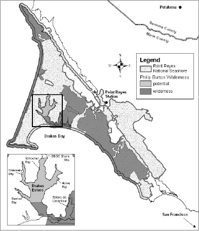
FIGURE 1.1. Drakes Estero is located within the Point Reyes National Seashore in Marin County, California. Inset provides larger view of Drakes Estero and shows the location of Drakes Bay Oyster Company (DBOC). Map courtesy of David Press, NPS (reprinted from NRC, 2009).
__________________
10 DEIS, p. 15.
11 DEIS, p. 11.
12 In 2004, the U.S. Department of the Interior Solicitor determined that, based on the intent of Public Law No. 94-544, Public Law No. 94-567, and NPS wilderness management policies, NPS had no authority to extend the RUO and SUP beyond November 30, 2012. DEIS, p. 2.
At the request of the NPS, the National Research Council conducted a study to help clarify potential impacts of shellfish farming on the ecology and socioeconomics of Drakes Estero (NRC, 2009). After evaluating the limited scientific literature available on Drakes Estero and relevant research on other similar ecosystems, the committee concluded that “there is a lack of strong scientific evidence that shellfish farming has major adverse effects on Drakes Estero” at current (2008-2009) levels of production and operating practices (NRC, 2009).
On October 30, 2009, Congress granted the Secretary of the Department of the Interior (DOI) the discretionary authority to issue a new 10-year SUP (Public Law 111-88, Section 124). This authority allows, but does not require, the Secretary to permit DBOC's continued nonconforming use of the potential wilderness area until November 30, 2022. DBOC submitted a request for the issuance of a new permit upon expiration of the existing authorizations. Thus, the NPS prepared an Environmental Impact Statement pursuant to the National Environmental Policy Act (NEPA) to inform this decision. Through the NEPA process, NPS engaged the public and evaluated the effects of alternatives related to the issuance of a new 10-year SUP for the commercial shellfish operation.
The Draft Environmental Impact Statement (DEIS), released in September 2011, examines DBOC operations and facilities in and adjacent to Drakes Estero, and offers four alternatives for consideration by the Secretary of the Interior with regard to the permit request (Box 1.1).
BOX 1.1
Four Alternatives Presented in the DEIS
Alternative A evaluates the “no action” alternative. If the Secretary of Interior does not approve renewal of the SUP, DBOC must terminate all shellfish mariculture, remove its personal property and nonconforming infrastructure, and undertake steps to restore the area to good order and condition.
The NPS DEIS also analyzes the impacts of three alternative scenarios with differing levels of shellfish production if the SUP were to be extended:
Alternative B would permit continued shellfish mariculture at the fall 2010 levels of operation (the date when NPS initiated evaluation under the EIS). Shellfish production would be limited to 600,000 lbs/yr; total acreage of the SUP area, both onshore and offshore, would be ~1,083 acres; Pacific and European flat oysters (Ostrea edulis, a non-indigenous species), and Manila clams could be grown in Area 1 (1,077 acres),13 and purple-hinged rock scallops could be grown in Area 2 (1 acre); new lease boundaries would exclude shellfish culture from harbor seal protected areas with a 100 yard buffer; boat routes, to be approved by NPS, would avoid seal protected areas and minimize prop damage to eelgrass beds. DBOC operations would be subject to NPS harbor seal protection protocol.
Alternative C would require a reduction in the current scale of DBOC operations, consistent with the conditions and operations that existed at the time the current SUP was signed in April 2008. Shellfish production would be limited to 500,000 lbs/yr; total acreage of the SUP area, including both onshore and offshore areas, would be ~901 acres; Pacific and European flat oysters could be cultivated in Area 1 (896 acres), Manila clams and purple-hinged rock scallops could be grown only in Area 2 (1 acre); new lease boundaries would exclude harbor seal protected areas with a 100 yard buffer; boat routes, to be approved by NPS, would avoid seal protected areas and minimize damage prop to eelgrass beds. DBOC operations would be subject to NPS harbor seal protection protocol.
Alternative D permits an increase in the scale of operations, and an additional or modified onshore facilities and infrastructure as requested by DBOC as part of the EIS process. Shellfish production is limited to 850,000 lbs/yr; total acreage of the SUP area, including both onshore and offshore areas, would be ~1,087 acres; Pacific, Olympia and European flat oysters, Manila clams, and purple-hinged rock scallops may be grown in Area 1 (1,082 acres; Area 2 would no longer be managed as a separate permitted area); new lease boundaries will exclude harbor seal protected areas with a 100 yard buffer; boat routes, to be approved by NPS, will avoid seal protected areas and minimize prop damage to eelgrass beds. DBOC operations would be subject to NPS harbor seal protection protocol.
__________________
13 See DEIS p. 61 and Table 2.5 (p. 122-125) for description of lease areas under the action alternatives and Figure 2-1 for map that shows locations of Areas 1 and 2.
The DEIS was open for public comment from September 23, 2011 to December 9, 2011, and three public open house meetings were held in the vicinity of the Seashore. More than 52,000 public comments were submitted to NPS during the comment period. The DOI commissioned an independent peer review of the DEIS (specifically Chapters 3 and 4) by Atkins, North America, specifically targeted at the scientific underpinnings of the DEIS. The peer review was tasked to “examine the scientific and technical information and scholarly analysis presented in the document and assess whether: (1) appropriate scientific information was used; (2) reasonable conclusions were drawn from the information; (3) significant information was omitted from consideration; and (4) NPS interpretation of the information is reasonable” (Atkins report, p. 1). In addition, in December 2011, Congress requested an NRC review of the scientific foundation of the DEIS. In May 2012, the NPS commissioned the NRC to conduct the review reported herein.
The ad hoc committee was given two tasks by the NRC: (1) Assess the scientific information, analyses, and conclusions presented in the Draft Environmental Impact Statement (DEIS) for Drakes Bay Oyster Company Special Use Permit and (2) evaluate whether the peer review of the DEIS conducted by Atkins, North America for the U.S. Department of the Interior, is fundamentally sound and materially sufficient. The committee was asked not to perform an independent evaluation of the environmental impacts of the proposed alternatives, but will restrict its findings to the strength of the scientific arguments in the DEIS and identify concerns, if any, not covered in the Atkins peer review.
The DEIS identifies and evaluates eleven (11) resource categories that may be affected by continued commercial farming of shellfish. Of these, the committee's evaluation is limited to eight (8): wetlands, eelgrass, wildlife and wildlife habitat, special-status species, coastal flood zones, soundscapes, water quality, and socioeconomic resources. Because the impact assessments for the other three (3) categories covered in the DEIS (wilderness, visitor experience and recreation, and the National Park Service [NPS] operations) are not based primarily on scientific research and analysis, the current study will not cover these topics nor will it review any policy or legal information.
National Environmental Policy Act
The NPS DEIS discussed herein was developed under the National Environmental Policy Act (NEPA) process. NEPA requires federal agencies to prepare Environmental Impact Statements (EISs) for “major federal actions significantly affecting the quality of the human environment” (NEPA, Section 102(2)(C)). The NRC committee is mindful that the DEIS is a NEPA document and not a scientific paper subject to the rigorous requirements of professional journal articles. While a NEPA document must be scientifically rigorous (see: e.g., 40 CFR § 1502.24), EISs are prepared for a lay audience and to inform the public and agency decision-makers regarding the potential environmental impacts of a proposed action and reasonable alternatives.
In addressing the statement of task, the committee understands that to “assess the scientific information, analyses, and conclusions” in the DEIS means to address whether, in the committee’s view, the data and analyses are consistent with academic scientific practice. The committee recognizes that such a standard may be different than those generally applied to documents prepared in conformance with NEPA. For example, scientists formulate conclusions based on the collection and analysis of data. By contrast, the EIS process requires formulation of conclusions based on the data and analyses that are available or that could be reasonably attained given time and resources, as long as it is sufficient to allow a decision maker to make a reasoned choice among alternatives. Therefore, in addition to evaluating the quality of the scientific information in the DEIS, the committee provides an assessment of the level of uncertainty in the conclusions reached in the DEIS to indicate the strength of the scientific evidence underlying these conclusions.
Approach and Organization of the Report
The NPS asked the NRC to provide a review of the DEIS on an expedited schedule of three months to fit within the timeframe of the NEPA analysis and the November 30, 2012 expiration of the Special Use Permit that allows DBOC to operate in Drakes Estero. As a consequence, the committee only convened one in-person meeting held at the National Academies’ Beckman Center in Irvine, California on July 9-12, 2012. On July 10 of the meeting, the committee held a public session open to organizations that have been involved in the DEIS or that otherwise have an interest in the DEIS to participate either in person or via web conference. The public session was organized to allow the committee members to efficiently gather information of relevance to their review of the DEIS through a question and answer session. Time was also set aside for public comment. The agenda and list of participants in the public session is available in Appendix D. Organizations and members of the public were also encouraged to submit information for the committee’s consideration in writing. These documents are part of the public record for this study, available through the National Academies’ Public Access Records Office,14 and posted on the internet.15
The committee’s evaluation of eight of the DEIS resource categories (wetlands, eelgrass, wildlife and wildlife habitat, special-status species, coastal flood zones, soundscapes, water quality, and socioeconomic resources) was conducted in three stages as follows:
(1) Review and compare the information and analysis provided for alternatives A, B, C, and D for each resource category by addressing the following questions:
• Are interpretations, analyses and conclusions scientifically sound based on (a) information and data provided in the DEIS, (b) additional results of scientific studies not considered in the DEIS, and (c) your expertise?
• Are there alternate conclusions that are equally sound or logical based on current scientific knowledge?
(2) Evaluate the Final Report on Peer Review of the Science Used in the DEIS (the Atkins report) against the committee’s evaluations of the DEIS to determine whether the peer review is fundamentally sound and materially sufficient.
(3) Provide suggestions for strengthening the scientific information in the final EIS.
The committee’s review of the DEIS begins with a discussion of observations related to how the DEIS analysis was framed (Chapter 2). The committee then evaluates the information, analyses and conclusions presented in the DEIS (Chapter 3). The evaluation includes a discussion of the uncertainty underlying the conclusions in the DEIS and offers alternative interpretations of the existing information where appropriate. Following the committee’s evaluation of the Atkins Peer Review (Chapter 4), the report concludes (Chapter 5) with a scientific assessment of the DEIS that leads to a set of suggestions for strengthening the science presented in the DEIS and reducing levels of uncertainty associated with the conclusions reported in the DEIS. The committee was not asked and hence does not comment on the sufficiency of the DEIS to meet NEPA requirements.
__________________
14www8.nationalacademies.org/cp/ManageRequest.aspx?key=49463.
This page intentionally left blank.


