


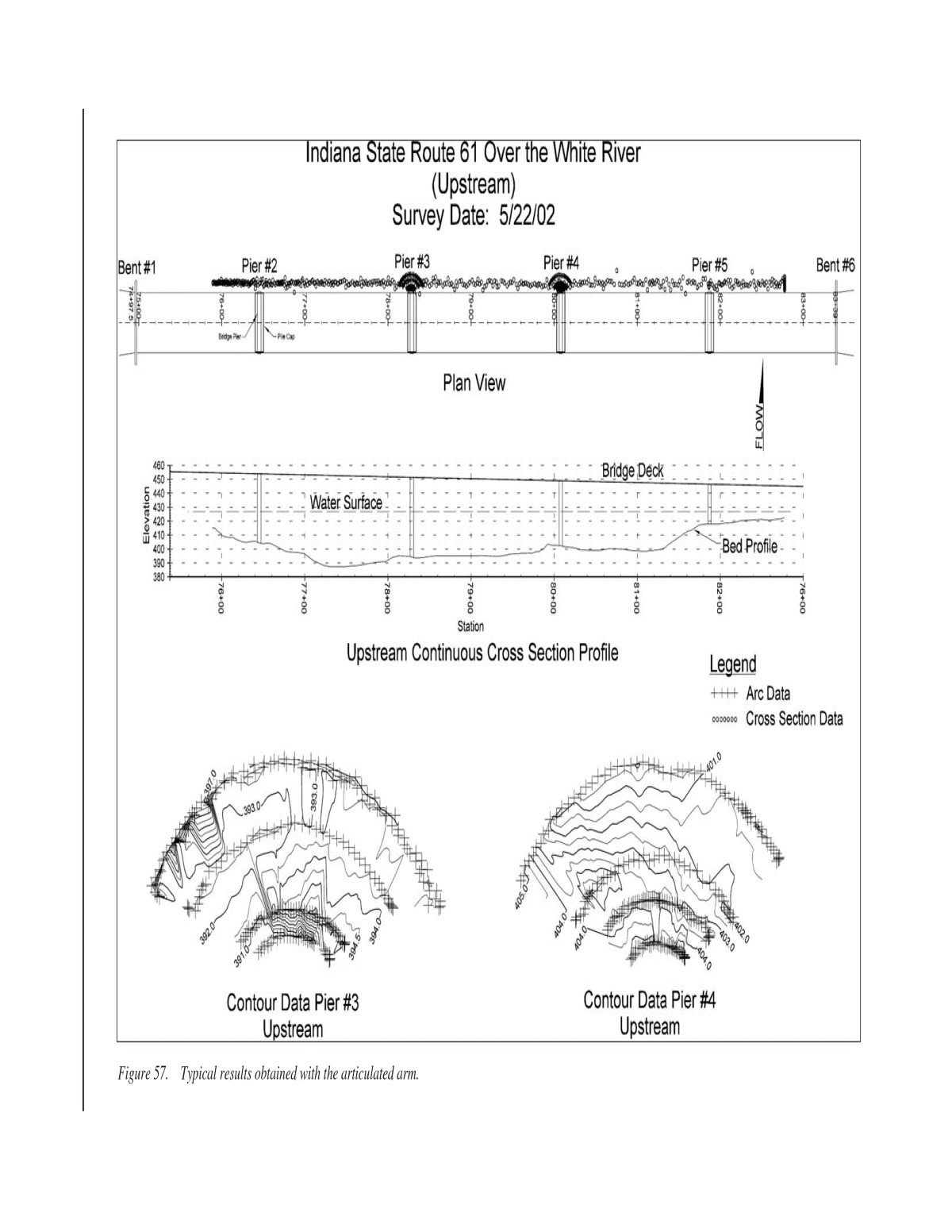
Below is the uncorrected machine-read text of this chapter, intended to provide our own search engines and external engines with highly rich, chapter-representative searchable text of each book. Because it is UNCORRECTED material, please consider the following text as a useful but insufficient proxy for the authoritative book pages.
5CHAPTER 2 FINDINGS LITERATURE SEARCH Information Sources The literature search was completed by investigating as many sources of potential information as possible. This in- cluded searching various computer literature databases, review of results from recent international scanning tours, assem- bly of relevant information obtained during the presentation of DP 97, and review of various trade publications. A search of various computer literature data bases did not identify many references on portable scour monitoring. Data- bases searched included the following: ⢠The TRB TRIS, ⢠The National Science Foundation, ⢠The American Geophysical Union Water Resources Research, ⢠The American Geophysical Union Earth and Space Index, ⢠ASCE Publications, and ⢠USGS Publications. Keywords used included instrumentation, scour, bridge scour, and scour monitoring. The most common source of literature was various bridge scour symposiums held at ASCE Water Resource Engineering Conferences from 1991 to 1998. These papers have been consolidated into a single ref- erence, âStream Stability and Scour at Highway Bridgesâ (3). The 1999 symposium is available through the conference proceedings. Similarly, not much information was available from recent scanning tours. A 1998 Scanning Review of European Prac- tice for Bridge Scour and Stream Instability Countermeasures was undertaken primarily to review and document innovative techniques used to mitigate the effects of scour and stream sta- bility. This tour was organized under the auspices of FHWAâs International Outreach Program by AASHTO through TRB. Although the focus of the tour was not scour measurement or instrumentation, results were reviewed in that context, and several contacts made in Europe were revisited, by e-mail and telephone, to identify any potential portable scour instru- mentation techniques. DP 97 was developed by the FHWA to facilitate tech- nology transfer of instrumentation-related research to the highway industry. The objective was to promote at the state and local level the use of instrumentation, both existing and new technology, to measure and monitor scour at bridges. The demonstration project was presented over 30 times to nearly 1,000 people between 1996 and 1999. Attendees often included inspectors and others responsible for field work, including bridge scour measurements sometimes made with unique and innovative equipment developed in house. To identify and document such experience and knowledge, the course evaluation forms from the various courses were reviewed and, in selected instances, requests for additional information or documentation were made to given states. Trade publications, such as Ocean News and Sea Tech- nology, also have articles and advertisements for specialized hydrographic survey equipment. Although most of this tech- nologically may not be directly applicable to scour measure- ments, because of size, complexity, or cost of the equipment, these magazines were reviewed for potential ideas and equip- ment sources. Literature Review Findings As described by Mueller and Landers (4), any portable scour measuring system includes four components: 1. An instrument for making the measurement, 2. A system for deploying the instrument(s), 3. A method to identify and record the horizontal position of the measurement, and 4. A data-storage device. The following sections describe the results of the literature review for each of these four components. Instrument for Making the Measurement The results of the literature review identified a range of methods for making a scour depth measurement during a flood. In general, these methods can be classified as follows: ⢠Physical probing, ⢠Sonar,
⢠Geophysical, and ⢠Other methods. Physical Probes. Physical probes refer to any type of device that extends the reach of the inspector, the most com- mon being sounding poles and sounding weights (1). Sound- ing poles are long poles used to probe the bottom. Sounding weights, sometimes referred to as lead lines, are typically a torpedo-shaped weight suspended by a measurement cable. This category of device can be used from the bridge or from a boat. An engineer diver with a probe bar is another example of physical probing. Physical probes only collect discrete data (not a continuous profile) and their use can be limited by depth and velocity (e.g., during flood flow condition) or debris and/or ice accumulation. Physical probes are not affected by air entrainment or high sediment loads and can be effective in fast, shallow water. Sonar. Sonar instruments (also called echo sounders, fath- ometers, and acoustic depth sounders) measure the elapsed time that an acoustic pulse takes to travel from a generating transducer to the channel bottom and back (1). Sonar is an acronym for SOund NAvigation and Ranging that was developed largely during World War II. However, early sonar systems were used during World War I to find both sub- marines and icebergs and called ASDICs (named for the Antisubmarine Detection Investigation Committee). As technology has improved in recent years, better methods of transmitting and receiving sonar and processing the signal have developed, including the use of digital signal processing (DSP). The issues of transducer frequency (typically around 200 kHz) and beam width are important considerations in the use of sonar for scour monitoring work. Applications of single-beam sonar range from âfish findersâ to precision survey-grade hydrographic survey fathometers. This type of instrument has been widely used for bridge scour investigations, particularly the use of low-cost fish-finder type sonar instruments. Based on work completed in part for the National Scour Study, Mueller and Landers (4) recommended a low-cost echo sounder (preferably a paper chart, and if not, a graphical display), and a tethered kneeboard to deploy the transducer for use in bridge inspection work. Their work also included development of a prototype remote-control boat for unmanned data collection. In 1994, Schall et al. (5) reported on the use of a similar device based on a fish finder and several different float designs for deploying the transducer, including a pontoon-style float and a foam board. Other types of sonar, such as side scan, multi-beam, and scanning sonar, are specialized applications of basic sonar theory. Side scan sonar transmits a specially shaped acoustic beam to either side of the support craft. These applications often deploy the transducer in a towfish, normally positioned behind and below the surface vessel. Although side scan sonar is one of the most accurate systems for imaging large areas of channel or ocean floor, most side scan systems do not pro- 6 vide depth information. Multi-beam systems provide a fan- shaped coverage similar to side scan, but output depths rather than images. Additionally, multi-beam systems are typically attached to the surface vessel, rather than being towed. Scan- ning sonar works by rotation of the transducer assembly, or sonar âhead,â emitting a beam while the head moves in an arc. Because the scanning is accomplished by moving the trans- ducer, rather than towing, it can be used from a fixed, sta- tionary position. Scanning sonar is often used as a forward- looking sonar for navigation, collision avoidance, and target delineation. Mellor and Fisher (6) reported on the use of side scan sonar at tidal bridges in North Carolina. Their study found good results with 100- and 500-kHz side scan imaging of large bridges, mapping significant areas both upstream and down- stream of the bridges that revealed areas of erosion, deposition, and paths of sediment transport. However, they expressed con- cern about collection of side scan data during storm events and commented on the laborious effort required to deploy and con- trol the towfish. The Sonar Scour Vision⢠system was developed by Amer- ican Inland Divers, Inc (AIDI) using a rotating and sweeping 675-Khz high-resolution sonar (7). The transducer is mounted in a relatively large hydrodynamic submersible, or âfish,â that creates a downward force adequate to submerge the transducer in velocities exceeding 20 fps (6 m/s). Given the forces created, the fish must be suspended from a crane or boom truck on the bridge. From a single point of survey, the system can survey up to 325 ft (100 m) radially. Data collected along the face of the bridge can be merged into a real-time 3-dimensional image with a range of 300 ft (90 m) both upstream and down- stream of the bridge. A low-cost scanning sonar was recently developed by Inter- phase Technology, Inc. The Interphase Twinscope⢠uses a phased array scanning technology to provide an affordable navigational sonar with the ability to look far forward and to the sides of the vessel. Geophysical. Surface geophysical instruments are based on wave propagation and reflection measurements. A signal transmitted into the water is reflected back by interfaces between materials with different physical properties. A pri- mary difference between sonar and geophysical techniques is that geophysical methods provide subbottom, while sonar can only âseeâ the water-soil interface and is not able to pen- etrate the sediment layer. The main differences between different geophysical techniques are the types of signals transmitted and the physical property changes that cause reflections. A seismic instrument uses acoustic signals, sim- ilar to sonar, but at a lower frequency (typically 2â16 kHz). Like sonar, seismic signals can be scattered by air bubbles and high sediment concentrations. A ground penetrating radar (GPR) instrument uses electromagnetic signals (typically 60â300 mHz), and reflections are caused by interfaces between materials with different electrical properties. In general, GPR will penetrate resistive materials and not conductive materi-
als. Therefore, it does not work well in dense, moist clays or saltwater conditions. A comprehensive investigation on the use of geophysical techniques in bridge scour was completed by Placzek and Haeni (8). In this investigation, measurements were typically taken at lower flow conditions and used to locate scour holes and areas of infilling. Results of this study demonstrated that geophysical techniques can be successfully used for bridge scour investigations. At the time of this investigation the cost and complexity of the equipment and interpretation of the data appeared to be limiting factors for widespread use and application. These issues have moderated as newer, lower- cost GPR devices with computerized data processing capa- bilities have been developed. However, GPR may still be limited by cost and complexity and, often, the need for bore- hole data and accurate bridge plan information to calibrate and interpret the results properly. Horne (9) reported on the results of a GPR investigation of bridges in New York. A 300-Mhz antenna floating on the water was most successful in penetrating silty, granular ma- terial in less than 2 meters of water. The availability of soil boring and samples provided both ground truth data and, more important, information to calibrate the natural material properties, such as density and gradation, with the radar wave travel time. A related investigation used GPR for high flow measure- ments by positioning the antenna above the water, which avoids the problems of placing instruments in the water at flood flow conditions (10). Results indicated that it was possible to estimate channel cross sectional area to within +/â 20 percent, or better; and, if the radar signal is calibrated to the specific site and time of measurement, the estimate is within +/â 10 percent. Other. Based on the results of the literature review, two additional methods were identified that might have applica- tion to portable scour measurements. One alternative is a small underwater camera, either alone or in combination with a sen- sor making a scour measurement. Such cameras are typically used for video inspection of pipe systems, boreholes, water wells, and tanks. Other applications include navigation cam- eras for remotely operated vehicles (ROVs) working offshore. Offshore cameras are often designed for either low-light or long-range viewing. Prices for combined video and lighting units start at about $3,000. The primary complications for their use in scour monitoring include the ability to position the cam- era close enough to see the scour hole in highly turbid water and to maintain adequate stability in the extremely turbulent conditions that exist in or near the scourhole. Another alternative is the potential application of a green laser as a sensor. Green lasers can operate in water up to depths of 70 ft (21 m); however, because these lasers are not yet devel- oped as a distance-measuring device and are still proprietary to the Department of Defense, they are not currently an option. They may become viable in the future with more research and development. 7 System for Deploying the Instrument The system for deploying the scour instrument is a critical component in a successful portable scour measurement sys- tem. In practical application, particularly under flood flow conditions, the inability to position the instrument properly is often the limiting factor in making a good measurement. The use of different measurement technologies from different deployment platforms can produce a wide variety of alterna- tive measurement approaches. Deployment methods for portable instruments can be divided into two primary categories: ⢠From the bridge deck and ⢠From the water surface. Bridge Deck Deployment. Bridge deck deployment fell into two categories: non-floating and floating (4). Non-floating systems generally involved standard USGS stream-gaging equipment and procedures, including the use of various equip- ment cranes and sounding weights for positioning a sensor in the water. This category could also include devices that use a probe or arm with the scour measurement device attached to the end. Probes or arms include things as simple as an extend- able pole or rod (such as a painterâs pole) to a remotely con- trolled articulated arm. Hand-held probes or arms are not generally useable at flood flow conditions. The Minnesota DOT has developed an innovative boom and sounding weight setup using a boom with a standard four- wheel drive winch for raising and lowering the sounding weight and a standard rope/wire rope counter for measuring the sounding distance. The boom, built by their maintenance shop at a very reasonable cost, is long enough to allow posi- tioning the weight under various flow and bridge conditions. A prototype articulated arm to position a sonar transducer was developed under an FHWA research project (11). An onboard computer calculated the position of the transducer based on the angle of the boom and the distance between the boom pivot and transducer. Additionally, the system could calculate the position of the boom pivot relative to a known position on the bridge deck. The system was mounted on a trailer for transport and could be used on bridge decks from 15 to 50 ft (5â15 m) above the water surface. Field testing dur- ing the 1994 floods in Georgia indicated that a truck-mounted system would provide better maneuverability and that a sub- mersible head or the ability to raise the boom pivot was nec- essary to allow data collection at bridges with low clearance (i.e., less than 15 ft or 5 m). Other sources of articulated arm technology include con- crete pumper trucks and other devices built primarily for the construction industry, such as those used to handle drywall sheets and concrete block. The latter type of devices might be a lower cost, commercially available option to a custom-built articulated arm. Another non-floating approach that might have application in scour monitoring is the use of the towed data acquisition
vehicles used in the offshore industry. These tethered vehicles submerge some distance below the water surface based on a servo-control elevator. Smaller, lower cost towed vehicles are available (about $5,000), with a cargo body in the 20-in. (50-cm)-wide range that can carry several pieces of equip- ment. Most are equipped with onboard electronics to measure and record depth and pitch data. Float-based systems permit measurement beneath the bridge and beside the bridge piers. Tethered floats are a low-cost approach that has been used with some success during flood flow conditions. Various float designs have been proposed and used to varying degrees for scour measurements, typically to deploy a sonar transducer. Common designs include foam boards, PVC pontoon configurations, spherical floats, water skis, and kneeboards (1). The size of the float is important to stability in fast-moving, turbulent water. Mueller and Landers (4) suggested using a conventional kneeboard with a nylon-covered Kevlar braid around the transducer cable to provide a single tether with adequate strength and abrasion resistance. They also reported good results under limited flood flow testing with a PVC style pontoon float. Floating or non-floating systems can be also be deployed from a bridge inspection truck, an approach that is particularly useful when the bridge is high above the water. For example, bridges that are higher than 50 ft (15 m) above the water typ- ically are not accessible from the bridge deck without using this approach. Water Surface Deployment. Water surface deployment typically involves a manned boat; however, because of safety issues related to flood conditions, the use of unmanned vessels has been suggested. The use of manned boats generally requires adequate clearance under the bridge and nearby launch facili- ties. This can be a problem at flood conditions when the river stage may approach or submerge the bridge low chord and/or boat ramps may be underwater. Smaller boats may be easier to launch, but safety at high flow conditions may dictate use of a larger boat, further complicating these problems. As an alternative to a full-sized survey boat, some compa- nies have developed a personal watercraft completely equipped for hydrographic surveying. These systems typically include a survey grade fathometer, a survey grade global positioning system (GPS), and radio communications to transmit data to a shore computer. When clearance is not an issue, the current and turbulence in the bridge opening may be avoided using one of the tethered floating or nonfloating methods described above from a boat positioned upstream of the bridge. For example, a pontoon or kneeboard float with a sonar transducer could be maneuvered into position from a boat holding position upstream of the bridge, thereby avoiding the current and turbulence problems at the bridge itself. Because of the safety, launching, and clearance issues, that an unmanned or remote control boat might be a viable alter- native has been suggested. A common use of unmanned ves- 8 sels has been in the offshore industry where ROVs have been widely used for oceanographic research. Recent improve- ments in technology for electrically powered systems lead to more low-cost ROVs (LCROVs) that have been developed primarily for use in inspection and observation. LCROV prices start at about $10,000, and their application to inland operations, typically in shallow water, has been growing rapidly. Such vehicles have been used for bridge footing inspections, dam and penstock inspections, boat salvage, intake and outlet inspections, and so forth. It is unknown if any of these systems would have enough power to operate in a river at flood flow conditions. Investigation of remote control boats for bridge scour data collection was completed by Skinner (12) and Mueller and Landers (4). Remotely controlled boats have been designed for hydrographic surveying in reservoirs, but such boats typ- ically do not have enough power to perform well in a river, particularly at flood flow. Skinnerâs design objectives focused on a relatively small, portable system that could be readily deployed from the bridge deck. He concluded that a small, flat-bottom, propeller-driven boat using an electric motor, and either a tether or acceptance of a lower design velocity, might be feasible for bridge scour applications. Mueller and Landers (4) developed a prototype unmanned boat using a small flat-bottom jon boat and an 8-hp outboard motor with remote controls. The boat included a wet-well to deploy instruments through the hull and was successfully tested during six flood events. Large-scale remotely controlled power boats might be an alternative for a remotely controlled, unmanned vessel. These boats range from 3 to 5 ft (1 to 1.5 m) in length and use con- ventional gas engines, often a modified gas engine from a line trimmer, which might have the power to operate in a river. This style of boat was first developed in the early 1980s and has become quite popular because of its ease of operation and low maintenance. These boats are commercially available, ready-to-run, for under $1,000. Given the size of the hull, the payload should be fairly large and yet, the boat could still be deployed from the bridge deck, and the motor would be power- ful enough to work at flood flow conditions. Alternatively, the engine and controls could be purchased and used on a differ- ent style hull, such as a small, flat-bottom design. This type of hull might have more payload and stability, at the expense of top speed, which is not a concern for this application. Method to Identify and Record the Horizontal Positions of the Measurement In order to evaluate the potential risk associated with a mea- sured scour depth, it is necessary to know the location of the measurement, particularly relative to the bridge foundation. Location measurements can range from approximate methods, such as â3 ft (1 m) upstream of Pier 3,â to precise locations based on standard land and hydrographic surveying technol-
ogy. A good review of these methods as applied to portable scour measurement is provided in the DP-97 class notes (1) and by Mueller and Landers (4). The most significant improvement in the approach to loca- tion measurement for portable scour applications may be in the use of GPS. Over the last 10 years, GPS has revolution- ized the way surveyors perform geodetic and control surveys on land. GPS is a positioning system that makes use of a âcon- stellationâ of satellites orbiting the earth. Perhaps one of the greatest advantages that GPS provides over traditional land- based surveying techniques is that line-of-sight between con- trol points is not necessary. A GPS survey can be completed between control points (even on opposite sides of a mountain) without having to traverse or even see the other point. GPS also works at night and during inclement weather, which could be a real advantage for scour monitoring during flood con- ditions. The most significant disadvantage of GPS is the inability to get a measurement in locations where overhead obstructions exist, such as tree canopy and, in the case of scour monitoring, bridge decks. The use of GPS technology has similarly changed the way hydrographic surveys are performed. The rapid changes and improvements in GPS technology, along with reduced cost, make this technology increasingly viable for portable scour measurements. For example, various manufacturers have a survey-grade, waterproof GPS receiver with a built-in antenna, memory, battery, and radio. These models are typically quite compact and could be used on a boat and possibly even on a floating or non-floating deployment system to track the posi- tion of the scour measurement continuously. Data collection under a bridge deck is still restricted, but it is often possible to get some distance under the bridge before all satellite cover- age is lost, particularly on bridges that are relatively high above the water. This type of technology is rapidly making most other traditional hydrographic surveying positioning methods (such as automated range-azimuth systems) obsolete. The accuracy necessary for survey operations requires the use of differential global positioning systems (DGPS). In DGPS, two or more receivers are used: one or more receivers are set up over known points (base stations), and a remote (or rover) GPS receiver is used to locate unknown points. Any errors in the system are defined by the base stations and a dif- ferential correction is applied to the rover. Differential pro- cessing can be accomplished through an existing network of base stations operated and maintained by various governmen- tal or private agencies. Alternatively, base stations in the sur- vey area can be established over known points to provide the differential corrections. Given that the accuracy of the survey is a function of the roverâs distance from the base stations, greater accuracy is often achieved using the latter technique. With more widespread use of GPS, more base station net- works have been established. The Coast Guard created one of the first networks of base station data along coastal areas that transmitted corrections on a marine radio frequency. More recently, a Nationwide DGPS (NDGPS) network is being 9 developed by a seven-agency partnership under a DOT ini- tiative to provide DGPS for public safety services. This net- work will extend throughout the country, not just the coastal areas. In other places, state agencies, sometimes in coopera- tion with universities, have established local DGPS networks. The use of DGPS with lower cost GPS receivers, such as those developed primarily for precision farming applications, may be a viable alternative for bridge scour monitoring. This approach is capable of sub-meter accuracy. An even lower cost GPS option is the recreational variety designed for sportsmen. The accuracy of these units may limit their application; how- ever, as technology continues to improve, these could become a viable low-cost alternative when sub-meter accuracy is not necessary. Currently, such units cost less than $500 and typi- cally provide position information within 30 to 65 ft (10 to 20 m) accuracy. With DPGS, accuracy of 3 to 16 ft (1 to 5 m) is possible even with these low-cost GPS receivers. Data Storage Devices Data storage devices include hydrometeorological data loggers, laptop computers, and, more recently, Personal Dig- ital Assistants (PDAs). Data loggers provide compact stor- age; however, they are generally not very user-friendly with each company typically having a unique programming lan- guage and approach. In field applications, laptop computers are bulky and need to be ruggedized to survive the rain, dirt, and dust of a field environment. PDAs may prove useful as their capability and user-friendliness continue to improve. The advantage to these approaches is the ability to integrate data reduction software, such as plotting or topographic mapping programs, to visual- ize the results, often in real time while the data collection occurs. Questionnaire To document recent information and experience of state transportation agencies, a survey was sent by mail to every State Hydraulic Engineer. In order to keep the survey short and to ensure a higher return rate, the primary objective of the sur- vey was simply to identify what states use portable techniques, what those techniques consist of, and what are their common problems and limitations in field application. A total of 31 sur- veys were returned. The type of equipment or procedures identified included the usual probing, weighted lines, fish-finder sonar, and div- ing. The most common response was sonar, particularly for flood monitoring. Not surprisingly, success was considered better during routine inspection work rather than during flood monitoring. Of the 25 general comments and observations received in Part C of the survey, 10 specifically mentioned that the equip- ment should be easy to deploy and use. These comments included phrases such as easily attached to existing vehicles;
deployed easily; operate with one person; more idiot proof; rapid deployment without traffic control; easily deployed; easy deployment; small hand-held point and shoot device; and, Simple system that . . . can be used in high velocity flood water. Five comments referred to the need for data logging, with phrases such as better data recording; digital recording; downloaded to a PC; . . . keep track of the information; and, data logging capability. Four also commented specifically on the need for durability with descriptors such as more bullet- proof; durable enough . . . ; rugged and dependable; and, . . . take a beating. Four commented on cost through words/phases such as inexpensive; price . . . wonât sell otherwise; cost . . . such that each district has ready access; and, . . . low cost. These conclusions are consistent with results reported by Mueller and Landers (4) from a similar survey effort. From their survey, they concluded the following: ⢠Transportation agency personnel use various techniques and equipment, including sounding weights and sonar devices. ⢠Most responses indicated that simplicity of operation is the most important functional characteristic. ⢠Other important features were portability and size, dura- bility, cost, and the ability to provide permanent records. ⢠An important operational criterion was the need to limit personnel requirements and supporting equipment. ⢠Most respondents considered $1,000 a reasonable price per unit. From this and other information received from the ques- tionnaire, the researchers concluded that a bridge inspection system should do the following: ⢠Measure streambed elevation. ⢠Be easily transportable and durable. ⢠Operate in water velocities of at least 13 fps (4 m/s). ⢠Be hand deployable. ⢠Be operable by one or two persons (preferably one). ⢠Be able to measure under the bridge and along the sides of piers and abutments. ⢠Provide a graphical or numerical display (permanent record is optional). ⢠Provide depth measurement accuracy of about 1 ft (0.3 m). ⢠Be powered by small portable batteries. FEASIBLE ALTERNATIVES The objective of this research was to develop improve- ments and/or alternatives to existing portable scour moni- toring equipment and techniques for measuring stream bed elevations at bridge foundations during flood conditions. Under flood conditions, the velocity of flow, sediment trans- port, and air entrainment can be high; debris loading can be a problem; and various different bridge geometries will be 10 encountered by the inspector attempting to make these mea- surements. Given these conditions, which represent the actual conditions that bridge inspectors must often work under, it is unlikely that one instrument or device will meet all the desir- able criteria and several different types of equipment will probably need to be developed. Based on the literature review, various observations and findings concerning portable scour monitoring techniques can be made. In particular, the combined results and conclusions from the two survey/questionnaire efforts provide significant insight on what people in the field using portable equipment would like to have, and this defined a fairly clear mandate for the proposed research. Specifically, devices that are relatively simple to operate and deploy, provide data logging capability, and that are durable and reasonably priced, seem to be high priorities. These characteristics are consistent with low-cost and easily transportable items in the criteria list defined as part of the research objective and suggest that complex, high-tech- nology approaches are not desirable. However, in certain cases, this may complicate meeting some of the other sug- gested criteria. The following sections discuss specific findings for each component of a scour measuring system. As stated above, the four components of a portable scour measurement system are as follows: 1. An instrument for making the measurement, 2. A system for deploying the instrument(s), 3. A method to identify and record the horizontal position of the measurement, and 4. A data-storage device. The use of different measurement technology (Item 1) from different deployment platforms (Item 2) could produce vari- ous alternative approaches. For example, it may be that the measurement technology is not dramatically new (e.g., phys- ical probing or sonar), but the deployment techniques are improved to facilitate flood flow monitoring and application from high bridges or bridges with low clearance. Alternatively, the measurement device might be something new or not currently used for scour monitoring deployed in a more traditional manner from the bridge deck or from a bridge inspection boat. Ideas include some of the offshore industry technology using side scan or multi-beam sonar, towfish, auto- nomous underwater vehicles (AUVs), and/or the use of under- water video cameras and flood lights. As will be described below, the research plan was directed more toward improving deployment techniques. Instrument for Making the Measurement Results from the literature review and questionnaire suggest that there are no innovative approaches currently available for measuring scour depth. The idea of an underwater camera and the application of a green laser were introduced as possible
scour monitoring devices, but both have serious limitations. The conventional methods (physical probing, sonar, and geo- physical), have all been used with varying degrees of success in flood monitoring work. Because of the drag forces created by high velocity and flow depth at flood flow conditions, phys- ical probing is generally not a viable approach. Large sound- ing weights have been used successfully at flood flow, but this approach can be somewhat slow and tedious. The technology for this type of measurement is already well developed and there is no apparent need to research or develop this method beyond current practice. Sonar technology, particularly single-beam methods often completed with fish-finder type devices, are widely used for scour monitoring. Although sonar has been used successfully for portable scour measurements, getting a good reading in shallow flow, high suspended sediment, and high-velocity conditions can be difficult. More complex sonar equipment, including side scan and scanning systems, have been used only on a limited basis and may be too complex and expen- sive for widespread use. One advantage of the more complex sonar techniques, particularly when implemented with a tow- fish (as used in the offshore industry), might be the ability to complete a measurement at a debris-laden pier by allow- ing the current to carry the towfish to the edge of, and per- haps even under, the debris pile. However, this could be a hazardous operation and could result in the loss of the tow- fish if it became entangled in the debris. An alternative is the low-cost scanning sonar sold by Interphase, which would reduce the economic risk of this approach, but not the haz- ards involved in implementing it. Although geophysical technology continues to improve, with reduced cost and easier operation, the widespread appli- cation of these devices for scour monitoring may still be limited by cost and complexity. If the radar antenna could successfully be placed above the water surface for measure- ment of the channel bottom, this could be a very useful and powerful methodology. System for Deploying the Instrument Bridge deck deployment methods are generally well devel- oped and include standard sounding reels, cranes, and sounding weight technology from the USGS and custom- fabricated boom devices, such as those developed by Minnesota DOT. Another option is the use of a commercially available boom (often called a non-articulating crane). These deployment approaches can be used for a direct physical probing (sounding weight measurement) or for positioning a sensor, such as a sonar transducer. A floating platform (e.g., kneeboard or pontoon float) is typically deployed directly from the boom cable and allowed to drift into position. This method generally works well, but can be more difficult on bridges that are high above the water surface or when the cur- rent is quite fast. 11 With additional research and development, the articulated arm could solve some difficult deployment problems, but the FHWA prototype that was developed may be limited in poten- tial application by cost and complexity. The research report for this prototype (11) indicated that the original plan was to develop an inexpensive, basic, and minimal system for deploy- ing a depth sounding transducer from a pickup truck on bridges that were within 20 ft (6 m) of the high-water surface. As the project progressed, it was decided to build a larger prototype that would have greater flexibility and wider application for field testing. The resulting product was a custom-fabricated articulated arm that was never widely adopted or implemented. If a commercially available articulated crane from another industry, such as the construction materials industry, could be adapted for scour monitoring applications, a lower cost device might be possible. A towed acquisition vehicle, similar to that used in the off- shore industry might be a viable approach for positioning a sensor when the device can be controlled from a boat upstream of the bridge or possibly using a crane off the bridge deck. This idea is similar to the towfish approach often used for side-scan sonar, but could be used with other measurement approaches, including simpler sonar devices. Boat-based application would limit this approach to larger rivers with boat ramp access and bridges without clearance problems. Although this idea has merit and might allow measurement under a debris pile, this operation is considered inherently dangerous. Water surface deployment by unmanned boats offers sev- eral advantages for flood monitoring work, including safety, access issues, and the ability to work at both low and high clearance bridges. Development of this concept will require research on boat hulls and propulsion systems. Method to Identify and Record the Horizontal Position The ability to measure and then record position data appears to be a high-priority criterion for any proposed system. The results of the survey/questionnaire suggested that those who have been using portable scour instruments would like the effi- ciency of a fully automated system. Specifically, not having to write data in a field book, as is often done with approximate methods (e.g., . . . scour depth of 12.5 ft at a location 3 ft in front of pier 8 . . .) or trying to merge land survey based mea- surements of position with independent scour depth measure- ments that then require additional office time to merge data sets and produce a final product (such as a plot of the cross sec- tion with the bridge substructure shown or a bathymetric map). Therefore, although these approaches can be used and may be expedient for certain situations, a valuable research contri- bution toward improving applied practice will be developing more automated positioning technology. The most attractive approach to automating the position measurement is to use GPS-based technology, recognizing
the limitations of not being able to work directly under the bridge in most cases and trying to resolve the accuracy- versus-cost issue. The easiest way to achieve sub-meter and even centimeter accuracy is to use a survey grade GPS receiver; however, with an investment of at least $20,000 for each receiver, this approach is limited by cost and the poten- tial risk of losing the device when working in the difficult con- ditions presented by flood-flow monitoring. Low-priced GPS receivers (< $7,500) can provide meter to sub-meter accuracy with differential positioning, which would be adequate for horizontal position in many cases, but certainly not for verti- cal. However, the scour measurement can be referenced to the water surface elevation or a reference elevation on the bridge deck, with the GPS data used only for horizontal position. Therefore, if a local DPGS signal is available (e.g., from the NDGPS network or some other source) a lower priced GPS unit on the deployment platform could be used, minimizing the cost risk while providing relatively accurate data. For bridge deck-based deployment using cranes or booms, horizontal position can be well controlled and referenced to the abutment. Methods of locating horizontal position across the bridge that are adaptable to automated data collection include distance measuring wheels and low-cost lasers. Data Storage Devices Data storage devices include data loggers, laptop com- puters, and, more recently, PDAs. Data loggers are generally not very user-friendly; laptop computers are susceptible to damage in a field-based application; and PDAs may be too limited in capability. If local telemetry were used to transmit data from the deployment platform, the best approach might be a laptop computer, with the operator at the side of the bridge, preferably in a vehicle. In this way, the computer can be used for both data collection and data reduction, perhaps in a real-time mode, while being protected from the environment. The use of PCs is much more common than it was even 5 years ago, and most people have a comfort level and a working knowledge of their operation. In contrast, PDAs are still evolving and changing rapidly, making it more difficult to develop a system for a specialized application, such as bridge scour data collection, without it becoming quickly outdated by the next generation of devices. PHASE II WORK PLAN Based on the literature review and Phase I findings, a detailed work plan was developed for Phase II. The alterna- tive technologies selected for further research, development, and testing under the Phase II work plan were as follows: 1. To document the custom-fabricated boom and winch setup developed by Minnesota DOT and any variations on that design; 12 2. To investigate the capabilities of the Interphase scan- ning sonar and its potential application to bridge scour work; 3. To research and develop an articulated arm device ade- quate for smaller bridges.; 4. To research the use of low-cost GPS for positioning in scour monitoring applications; and 5. To research and develop data collection software suit- able for laptop computer application that facilitates data collection, analysis, and reporting. It was recommended that off-the-shelf products be used, where possible, for each component of the above systems. This would facilitate the purchase, construction, and repair of the resulting portable scour monitoring equipment and keep the total cost reasonable. The following paragraphs summarize the Phase II objectives for each alternative. Alternative 1âMinnesota Boom Setup The objective of this task was to document the winch con- cept developed by Minnesota DOT and evaluate potential improvements to the design and/or how it is used in scour mon- itoring. This could include evaluating the various components used to fabricate the winch system, the mounting concepts for the winch, and the use of the winch on different types of cranes. Of interest was the application of this concept to a pickup truck, rather than a large flatbed truck. Alternative 2âInterphase Scanning Sonar This objective of this work was to evaluate the use of rela- tively low-cost Interphase scanning sonar for scour monitoring, based on limited testing under laboratory or field conditions. Alternative 3âArticulated Arm Devices Based on work completed by the FHWA on an articulated arm device, the objective of this work was to develop an alter- native design that is smaller, less complicated, and more cost- effective. Different types of commercially available articulated arms will be investigated and methods for tracking the angular position of the arm evaluated. A prototype device will be built and tested in detail. Alternative 4âLow-Cost GPS Positioning System The objective of this testing was to evaluate the application of a lower cost GPS receiver for bridge scour monitoring. Field testing around a bridge will be used to establish guide- lines for when and where this type of positioning will work and when it should not be considered.
Alternative 5âData Collection Software Efficient data collection is important in a flood monitoring situation. The objective of this work was to develop a Windows-based software to automate the data collection process. Ideally, the software would not only automate the data collection process, but also provide immediate access to the results, which could include a cross section plot or bathy- metric map. PROTOTYPE DEVELOPMENT AND LIMITED TESTING Minnesota Boom Original Design Minnesota DOT developed an innovative boom and sound- ing weight system for scour depth measurements using a boom truck and a custom-fabricated winch setup. The use of a boom and winch to deploy a sounding weight is not a new concept and has been used extensively for stream gaging measure- ments for many years. More recently, various boom and winch configurations have been used for measuring scour depths at bridges. In some cases, these were custom-fabricated devices; in other cases, they were standard stream gaging boom and winches (technically called sounding reels in stream gaging work), as shown in Figure 1. The Minnesota DOT setup was unique in that the winch was not mounted on the boom itself. This has been the traditional approach for stream gaging operations and also has been com- monly used in bridge scour measurements. Instead, the winch was mounted on a frame that was attached to the truck bed (Figure 2). The winch could swivel and tilt to allow the cable to follow the movement of the articulated arm crane that 13 Minnesota DOT was using. This particular crane was capable of extending to 40 ft (12 m). This design allowed adding the sounding weight capability to the truck without modifying the articulated crane, which is used for other purposes when it is not being used for scour inspections. This design also facilitated installing and remov- ing the winch, as necessary, and using the same winch setup on various trucks. Although this was a relatively simple adap- tation of a standard deployment concept, it simplified building and adapting sounding reel capability on any available boom and could be readily adapted to both articulated and non- articulated (straight) booms or cranes. The following para- graphs describe the design and construction of the Minnesota DOT winch in greater detail. To document the design of the Minnesota DOT winch, a trip was made to the DOT office in Mankato, Minnesota, where the boom was fabricated. Pictures and measurements were taken to document the device. Discussions were also held with the bridge inspection crew that developed the device to obtain sug- gested improvements to the design, based on experience to date. Generally, the device as built has performed quite ade- quately, and only minor changes to the design were suggested by the inspection crew. The winch used was an X3 Superwinch⢠(Figure 3), with the cable routed through a Hykon Reel⢠wire rope length counter (Figure 4). The X3 winch has a 1.6 hp motor and 50 ft (15 m) of 7â32 inch (5.5 mm) wire rope with power in and out and freespooling capability. The rated line pull is 4,000 lbs (1,814 kgs) on a single line. The Hykon Reel is made by Hykon Manufacturing Company and can accommodate flex wire from 1â64 in (0.4 mm) to 7â8 in (22 mm) and wire rope to 1â2 in (13 mm). A guide was fabricated at the outlet of the wire rope counter to better control the cable and to direct it toward the pulley at the end of the boom. The frame for the winch and wire rope counter was custom fabricated and included a place to attach a safety chain to the truck bed. Figure 1. USGS type stream gaging crane being used for scour monitoring. Figure 2. Minnesota DOT winch mounted on bed of truck.
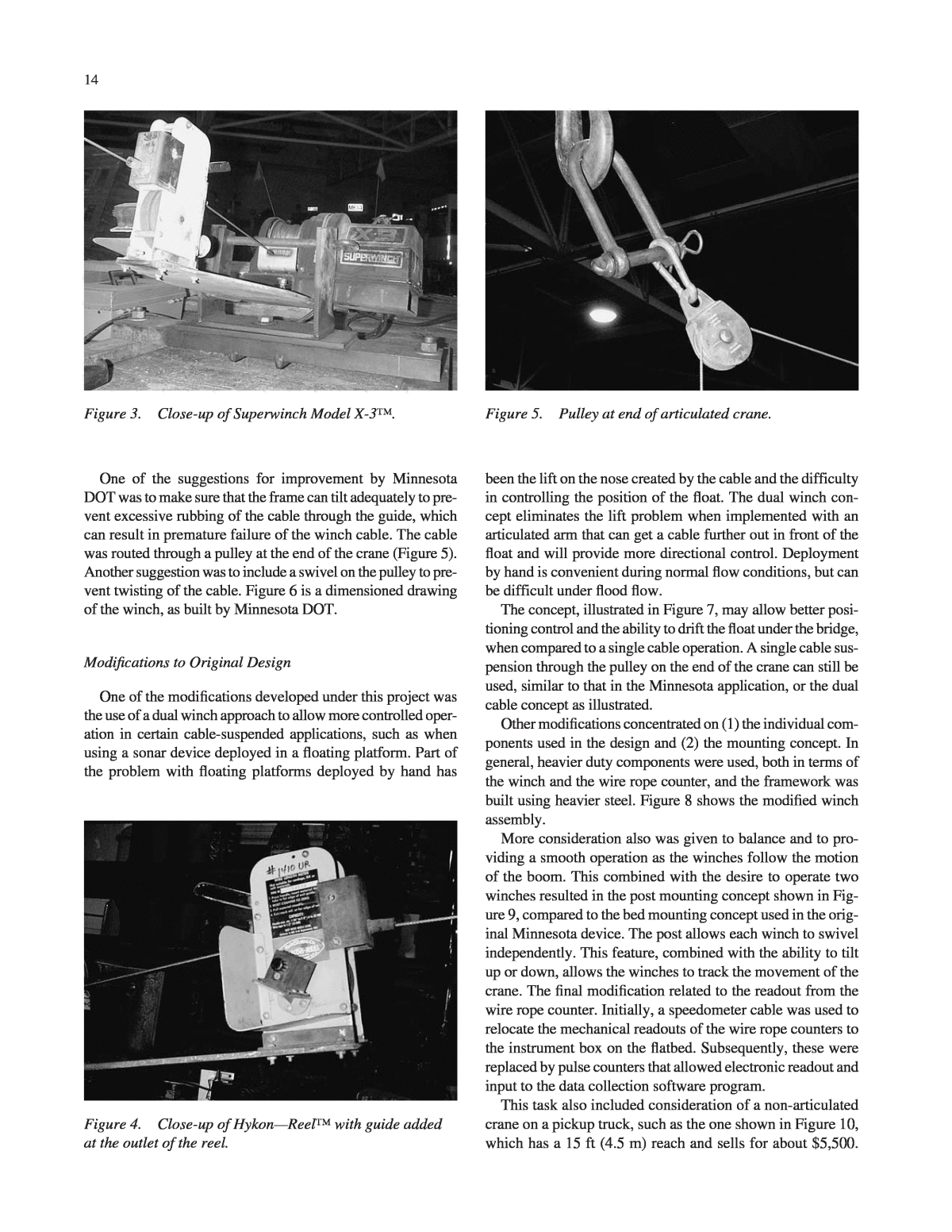
One of the suggestions for improvement by Minnesota DOT was to make sure that the frame can tilt adequately to pre- vent excessive rubbing of the cable through the guide, which can result in premature failure of the winch cable. The cable was routed through a pulley at the end of the crane (Figure 5). Another suggestion was to include a swivel on the pulley to pre- vent twisting of the cable. Figure 6 is a dimensioned drawing of the winch, as built by Minnesota DOT. Modifications to Original Design One of the modifications developed under this project was the use of a dual winch approach to allow more controlled oper- ation in certain cable-suspended applications, such as when using a sonar device deployed in a floating platform. Part of the problem with floating platforms deployed by hand has 14 Figure 4. Close-up of HykonâReel⢠with guide added at the outlet of the reel. Figure 5. Pulley at end of articulated crane. been the lift on the nose created by the cable and the difficulty in controlling the position of the float. The dual winch con- cept eliminates the lift problem when implemented with an articulated arm that can get a cable further out in front of the float and will provide more directional control. Deployment by hand is convenient during normal flow conditions, but can be difficult under flood flow. The concept, illustrated in Figure 7, may allow better posi- tioning control and the ability to drift the float under the bridge, when compared to a single cable operation. A single cable sus- pension through the pulley on the end of the crane can still be used, similar to that in the Minnesota application, or the dual cable concept as illustrated. Other modifications concentrated on (1) the individual com- ponents used in the design and (2) the mounting concept. In general, heavier duty components were used, both in terms of the winch and the wire rope counter, and the framework was built using heavier steel. Figure 8 shows the modified winch assembly. More consideration also was given to balance and to pro- viding a smooth operation as the winches follow the motion of the boom. This combined with the desire to operate two winches resulted in the post mounting concept shown in Fig- ure 9, compared to the bed mounting concept used in the orig- inal Minnesota device. The post allows each winch to swivel independently. This feature, combined with the ability to tilt up or down, allows the winches to track the movement of the crane. The final modification related to the readout from the wire rope counter. Initially, a speedometer cable was used to relocate the mechanical readouts of the wire rope counters to the instrument box on the flatbed. Subsequently, these were replaced by pulse counters that allowed electronic readout and input to the data collection software program. This task also included consideration of a non-articulated crane on a pickup truck, such as the one shown in Figure 10, which has a 15 ft (4.5 m) reach and sells for about $5,500. Figure 3. Close-up of Superwinch Model X-3â¢.
15 H Figure 6. Dimensioned drawing of Minnesota style winch.
Given the reach of an articulated arm, and the value of han- dling larger sounding weights with larger winches, a smaller device on a pickup, while feasible, may not be attractive for flood monitoring applications. Interphase Scanning Sonar The Interphase Twinscope⢠(Figure 11) is a forward- scanning sonar using a proprietary phased array acoustic tech- nology. An acoustic array is a group of piezoelectric ceramic elements precisely sized and spaced. Each element can send and receive acoustic pulses, similar to conventional single- element depth sounders. However, when all elements in the array are sending or receiving acoustic energy at the same time, the entire array behaves like a single larger element with one important difference: the ability of the array to concentrate its acoustic energy in different directions, depending on the dif- 16 ferent phasing of the signals applied or received by each ele- ment. Depending on signal phasing, acoustic beams can be directed in an almost unlimited number of directions. The Twinscope⢠uses a 16-element array and can steer the acoustic beam in any of 90 different directions in either the horizontal or vertical direction. Conventional fixed-beam sonar technology would require 180 different elements to duplicate this capability, and the resulting transducer would be too large and costly for practical use. Given that the acoustic Figure 7. Two winch concept for cable suspended operations. Figure 8. Modified winch design. Figure 9. Winch system on the truck. Figure 10. Application of winch concept on a non- articulated crane.
17 ing was conducted at a pump station intake on the lake sup- plying water for some of the outdoor flumes and in the sump under the indoor laboratory. The pump station on the lake has a large platform on piles supporting the pump and its intake. However, the number of piles and cross bracing prevented getting a clearly identifiable return of a single pile on the screen. The testing in the sump adjacent to one of the pump intakes provided a clearer picture, because the transducer was seeing only the pipe for the pump intake extending down into the water, but the screen image was complicated by multiple returns from the various walls and partitions of the concrete- lined sump (Figure 13). A field test of the Twinscope⢠was conducted in Alabama. For testing purposes, a special bracket was fabricated to allow the Twinscope⢠transducer to be mounted on the crane (Fig- ure 14). Figure 15 shows the transducer positioned in the water upstream of the pile. This test was inconclusive. Based on sub- sequent discussions with the manufacturer, it was concluded that there must be at least 10 ft (3 m) of water for this device to workâa situation that did not exist at this bridge. No addi- beam is steered electronically, with no moving parts, it can quickly scan and rescan a large area. Phased array technology also allows the user to adjust beam width, which is not possi- ble with conventional fixed-beam sonar. In the Twinscope⢠array, 8 of the 16 elements are used to scan vertically, from straight ahead to straight under the boat, and the other 8 are used to scan forward from side-to- side. In horizontal mode, the side-to-side sweeping action of the scanning beam is up to 45 degrees on either side of the boat, angled downward at about 20 degrees. The cone angle of the Twinscope⢠is approximately 12 degrees, so in ver- tical mode, a forward scan to 1,000 feet in front of the boat would see targets across a 210-foot width (105 feet on either side of center). Initial testing of the Twinscope⢠was conducted at the Hydraulics Laboratory at Colorado State University (CSU). The transducer was mounted in a pontoon float for testing, and positioned with an extendable pole (Figure 12). Test- Figure 11. Interphase Twinscope⢠sonar. Figure 12. Pontoon float with transducer adjacent to pump intake in the CSU Hydraulics Laboratory. Figure 13. Horizontal scan showing multiple reflections. Figure 14. Mounting the Twinscope⢠transducer for field testing.
tional testing of the Twinscope⢠was conducted; however, under the proper conditions, the Twinscope⢠should provide a graphical perspective of conditions approaching a pier and might be a useful addition to the instruments used by a bridge inspection crew during scour monitoring. Articulated Arm Crane Research Articulated arm cranes are also known as knuckle boom or folding cranes. There are various manufacturers of articulated arm cranes. The first step in the investigation of feasible alter- natives for use in a scour monitoring application was to con- tact various dealers across the country to obtain specific design and cost information. This was accomplished through web browsing, telephone conversations, and review of litera- ture provided by the dealers and/or manufacturers. Based on this research, four major crane manufacturers were consid- ered: Palfinger, Effer, Jabco, and National. For each manu- facturer, a specific model was selected that could be used for scour monitoring applications and preliminary cost informa- tion (2001 data) was researched. The results of that research are as follows: ⢠The recommended Palfinger crane was model PK 4501 C. This crane has a maximum reach of 36 ft (11.0 m) with a lifting capacity at this distance of 600 lbs. The base price for this crane is $14,500, with an installation cost of $1,800. This crane could be installed on a Ford F-450 truck or equivalent. The cost for this truck new is $31,800 plus $4,000 for a flatbed. Therefore, the total cost for this crane, new truck, flat bed, and installation would be approximately $51,000. 18 ⢠The recommended Effer crane was model 28/3S. This crane has a maximum reach of 30.3 ft (9.2 m) with a lift- ing capacity at this distance of 650 lbs. The base price for this crane is $10,000, with an installation cost of $3,500. This crane could also be installed on a Ford F-450 truck or equivalent. The cost for this truck new is $31,800 plus $4,000 for a flatbed. Therefore, the total cost for this crane, new truck, flat bed, and installation would be approxi- mately $49,300. ⢠The recommended Jabco crane was model 705/3S. This crane has a maximum reach of 32.6 ft (9.9 m) with a lift- ing capacity at this distance of 880 lbs. The base price for this crane is $16,000, with an installation cost of $3,500. This crane could also be installed on a Ford F-450 truck or equivalent. The cost for this truck new is $31,800 plus $4,000 for a flatbed. Therefore, the total cost for this crane, new truck, flat bed, and installation would be approximately $55,300. ⢠The recommended National Crane was model N-50. This crane has a maximum reach of 40 ft (12.2 m) with a lift- ing capacity at this distance of 700 lbs. The base price for this crane is $20,500, with an installation cost of $8,500. This crane is larger and heavier than the others and would require a slightly larger truck, such as a Ford F-500 or equivalent. The cost for this truck new is $33,700, plus $4,000 for a flatbed. The total cost for this crane, new truck, flat bed, and installation would be approximately $66,700. Based on this information, the cost for the crane and instal- lation, excluding the truck cost, varies from $13,500 to $29,000, with the Effer crane being the lowest and the National Crane being the highest. Although there was some difference in reach and lifting capacity, that alone did not seem to explain the wide range of cost. When asked about the range in price, the National Crane representative suggested that the other cranes being considered were all manufactured in Europe and were not built to as strin- gent safety standards as cranes manufactured in the United States. The opinion of the Jabco representative was that the foreign companies have more background and experience in the design and manufacture of knuckle boom cranes. It was his observation that they have had to deal with narrow streets and limited access issues for years, where knuckle boom cranes can be particularly useful over straight arm cranes. Addition- ally, he indicated that many of the European cranes are made of high alloy steel and, as a result, there is less structural steel, and therefore, less cost. The additional weight of the crane, such as the National Crane, also required the use of a larger truck, as discussed above. Crane Selected for Purchase These issues entered into the decision for the type of crane selected for this project, with the desire to work with a smaller Figure 15. Positioning the Twinscope⢠transducer upstream of a pile.
crane that could be mounted on a smaller truck. This criteria was to improve maneuverability, as well as to minimize lane closure and traffic control issues. Additionally, as a research project, it was important to have a dealer and manufacturer who were willing to be helpful and responsive to unique requests as it related to equipment application outside the normal range of use. Based on all these issues, a Palfinger 4501C crane was purchased (Figure 16). The final cost breakdown for the crane and truck are provided in Table 1. Mounting the Crane on the Truck The most common location for a crane is immediately behind the cab of the truck. An alternative location is at the back of the truck, behind the rear axle. A rear mount puts more load at the back of the truck and can cause weight distribution problems if the truck is also carrying substantial weight on the flat bed. The rear mount provides better clearance around the truck, because the cab is not in the way. For purposes of scour monitoring, with no substantial weight being transported on the truck bed, a rear mount seemed advantageous. Based on the reach of the PK4501C crane, mounted with an offset to the center of the truck, the PK4501C has the capabil- ity to reach 21.25 ft (6.5 m) below the bridge deck when the truck is a maximum of 35 in (0.3 m) from the edge of the bridge. This reach is to the end of the crane, prior to adding any extensions for sensor mounting. Figure 17 summarizes the geometric capabilities of this crane when mounted on a Ford F-450 truck. 19 Modifications to the Rotator The ability to provide pan and tilt operations at the end of the crane was considered a valuable feature for positioning instrumentation. Pan operation could be accommodated using a standard hydraulic rotator, often used with construction equipment on the end of a crane (Figure 18). Most rotators are designed for 360-degree, continuous rotation at a fairly high speed. Continuous rotation for scour monitoring applica- tions was not desirable, given that the operator might acciden- tally tear off cables connected to transducers, and high-speed operation would complicate precise positioning and could result in possible impact damage when in close proximity to the bridge. In the past, rotators with a 270-degree rotation were avail- able; however, most construction operations require full rota- tion and the limited rotation devices are no longer available. After working with engineers at the crane manufacturer, it was concluded that the only economical solution was to use flow restrictors in the hydraulic lines to slow down the motion and to use some type of limit switch or indicator as part of the position-sensing device to control overrotation. Standard rotators are also designed to hang from the crane on a pin connection, so that the rotator is always positioned vertically, regardless of the angle of the crane arm. Therefore, providing tilt capability required modifications and special fabrication. An additional hydraulic cylinder and custom- fabricated brackets were added to the rotator to provide the tilt action (Figure 19). The tilt was designed to provide about 35 degrees toward the bridge and about 10 degrees away from the bridge, when the crane is positioned vertically over the bridge rail. The mounting bracket for the rotator was attached to the end of the crane, which extended the reach of the crane by 1.5 ft (0.46 m). Modifications to the Truck Flat Bed The modifications to the truck bed included adding ladders on both sides to facilitate access, building the workstation area for the computer and instruments, and relocating the hydraulic controls to the flatbed. The hydraulic controls for an articulated crane are typically located next to the crane, allowing operatorFigure 16. Palfinger PK4501C crane. TABLE 1 Crane and truck cost information Item Cost ($) (excluding tax, licensing, etc.) Palfinger 4501C Crane 14,553 Installation, including PTO pump 1,500 10-foot truck bed, installed 1,500 2001 Ford F-450 25,550 Subtotal-base cost for truck and crane 43,103 Kinshofer Hydraulic Rotator 3,600 Tool boxes, beacon lights, etc 2,000 Total Cost (estimated as of 12/31/01) 48,703
20 Figure 17. Reach below the bridge deck with the PK4501C crane on a Ford F-450 truck. access while standing on the road (Figure 20). Some models, including the Palfinger 4501C, have dual controls allowing operation from either side of the truck. After reviewing the truck and crane operation, it was con- cluded that it would be better to relocate the controls from the standard location for reasons of safety and to provide better visibility of river conditions for the operator. To reach over the side of the bridge, it will be necessary to position the truck as close to the edge of the bridge as possible, which may restrict access for the operator on the bridge side of the vehicle. Access from the opposite side, when the crane is equipped with dual controls, would still be feasible, but visibility to the water sur-
face would be limited from that location and roadside safety would be a concern. Moving the control valves up onto the flatbed eliminated the access and safety issues related to operation from the road sur- face and greatly improved the visibility to the water surface for the operator. The controls were moved to a position at the back of the flatbed, a workstation was fabricated on the flatbed to provide a shelter for the computer, and a seat was installed on the bed (Figure 21). 21 Tracking the Position of the Crane Various sensors were installed on the truck and crane to allow geometric calculation of the position of the end of the rotator. An articulated crane provides a very stable platform to deploy scour measurement devices, but does not provide any positioning information without the addition of other sensors to track the movement of the crane. Therefore, a crit- ical part of the articulated crane research was to develop a methodology to track the location of the end of the crane in a real-time mode as the crane was being operated. It was also necessary to define the position of the truck on the bridge deck. Initially, 10-turn potentiometers with various gearing arrangements were used to measure the azimuth of the crane Figure 18. Standard rotator (prior to modifications to allow tilt). Figure 19. Rotator after modifications to provide tilt capability. Figure 20. Hydraulic controls in typical location allowing operation from roadway. Figure 21. Instrument shelter for computer and relocated hydraulic controls.
and the rotator. However, these were not as robust as needed, and alternative methods were investigated. Subsequently, the potentiometer for the azimuth measurement was replaced with a 50 in. (125 cm) linear environmentally sealed draw wire. The draw wire was routed around a 15-in. (38-cm)-diameter circu- lar plate mounted near the base of the crane (Figure 22). The draw wire was permanently mounted to a bracket on the truck bed and a groove on the edge of the plate kept the draw wire in place as the crane rotated. This solution was not feasible for the rotator, and no other alternatives were identified. Therefore, the 10-turn potentiometer was retained. Tilt meters were used to measure the deflection angle of the crane arm and the rotator arm. The tilt meter for the crane arm was mounted inside the instrument box attached to the end of the crane (Figure 23). The tilt meter for the rotator arm was attached directly to the support bracket fabricated to allow tilt- ing the rotator (as described above). A 400 in. (10 m) envi- ronmentally sealed draw wire was used to measure the linear extension of the arm (Figure 24). Tilt data for the crane and rotator, the azimuth of the rota- tor, and the linear extension of the arm are transmitted by a wireless modem from an instrument box at the end of the crane that also transmits sonar data. The data are pre-processed with a Campbell CR10 data logger prior to transmission to the com- puter on the truck (Figure 23). An acoustic stage sensor was used to measure the distance to the water surface (Figure 25). A second CR10 mounted in the instrument shelter on the truck bed was used to process truck data, which included the azimuth of the crane, winch data, the distance to the water surface, and the distance trav- eled across the bridge deck. A computer with two serial ports was used to process the data from each data logger, sent as serial data strings. Knowing the rotation of the crane and the rotator, the deflection angles of the crane arm and rotator, and the extension of the crane arm 22 allowed geometrically calculating the position in space of the end of the rotator relative to the center pivot of the crane where it was mounted to the truck bed. Tracking the Position of the Truck on the Bridge Deck Tracking the position of the truck on the bridge deck was the last piece of information necessary to locate the scour mea- Figure 22. Attachment for crane azimuth measurement using draw wire. Figure 23. Tiltmeter installed in the instrument box at the end of the crane. Figure 24. Draw wire used to measure linear extension of crane.
surements accurately. Initially, the use of low-cost GPS was considered, but that approach was not found to be feasible (see below). Given that the truck would always be positioned as close to the curbline or barrier rail as possible, and given that the bearing of the bridge is a known quantity, the only real location information necessary was the distance the truck had been driven across the bridge, and the elevation of the truck. The elevation of the truck could be established from the elevation of the bridge deck, as given on bridge plans, and the height of the truck bed above the bridge deck. There- fore, the primary field measurement necessary to locate the truck was simply the distance the truck had traveled across the bridge deck. Various methods were considered to establish the distance traveled. To be useful, the measurement device had to be accurate, simple to use, and able to output a serial data string. Laser measuring devices were considered because of their high accuracy and simplicity. However, because the laser must hit a target at the end of the bridge, there was concern about reflecting off the wrong target and the potential difficulties of getting a measurement when the bridge had a horizontal or vertical curve. Electronic distance meters are available for installation on vehicles used for various highway survey projects (e.g., mea- sure guard rails, pole or sign signing, and estimate pavement areas). For example, the Nitestar⢠system computes the dis- tance traveled by attaching to the speed sensor in the vehicleâs transmission. This device has a calibration feature that can be used to account for change in tire size because of wear and under or over inflation of tires and is accurate to 30 cm over 1.6 km (1 ft per mile). It has RS-232 output capabilities that allow it to record data into a computer, which can be viewed by Nitestar software or by user-defined software. The cost of this unit with the appropriate installation kit was approxi- mately $700 dollars. 23 Based on simplicity, cost, and accuracy, this system was purchased and installed on the truck. However, this meter caused a fault in the truck anti-lock braking system and was also found to be difficult to interface with the data collection program being developed. Therefore, it was replaced with a standard surveying measuring wheel attached to the back of the truck (Figure 26). The only limitation of standard survey wheels is that they use a mechanical counter and do not have any electronic output capability. To provide a serial data string, pulse counters were added to the wheel to register electroni- cally the distance traveled. Scour Measurement Devices As developed, the instrumented, articulated crane could be used to position various scour measurement devices, both directly from the end of the crane and from cable-suspended methods using the winches. Sonar could be deployed off the end of the crane, or as a cable-suspended operation, while direct probing was possible off the end of the crane. To provide sonar measurement capability, a sonar instru- ment with all the electronics built into the transducer head was selected (Figure 27). The sonar outputs a serial data string of depth and temperature that was connected to the Campbell CR10 data logger and transmitted by the wireless modem (as shown in Figure 23). This eliminated having to route any elec- tronic cables for the sonar from the water surface to the bridge deck. Given the desire to operate at flood conditions with high velocities, a streamlined probe was built to position the sonar transducer directly in the water using the articulated arm. The probe was fabricated from a section of helicopter blade and proved to be very stable when placed in high-velocity flow during field trials. The streamlined probe eliminated the vor- tex shedding problems of a simple cylinder-shaped rod ex- posed to high-velocity flow. Figure 25. Acoustic stage sensor used to measure distance to the water surface. Figure 26. Surveyors wheel mounted to rear bumper of truck.
The initial design for the streamlined probe had a rigid mount to the rotator, requiring the operator to turn the rotator as the crane angle changed, in order to keep the fin aligned with the current (Figure 28). This design was modified to allow the fin to swivel and track the current on its own; however, the axis of rotation was too far back on the fin and it would not track the current in low-velocity situations. A third version was built with the rotation point moved forward, as well as being built with a longer extension that provide more reach with the crane arm and less chance of submerging the rotator and instrument box at the end of the crane (Figure 29). The length of the extension was 80 in (2 m). Given the distance 24 the crane could reach below the bridge deck (21.25 ft or 6.5 m) and the length of the rotator mounting bracket (1.5 ft or 0.46 m), the crane could reach nearly 30 ft (9.1 m) below the bridge deck for a sonar measurement. To provide physical probing capability, an extendable rod was fabricated. The rod extensions were built with 125 mm stainless steel, Schedule 80 pipe in 1.5 m lengths, allowing a total length up to 4.5 m. Threaded unions allow individ- ual sections to be connected to create the longer extensions. Using the articulated crane for physical probing is most appropriate in a gravel/cobble bed or to evaluate riprap con- ditions, because the strength of the crane hydraulics makes it difficult to know exactly when a soft channel bottom is reached. Cable-suspended operations were possible using the two Minnesota-style winches described above. Using a single- or dual-winch approach, traditional sounding weight measure- ments can be made. The dual-winch approach reduces the size of the weight necessary, because the winch running through the end of the crane can be used to limit the movement under the bridge deck. Although the weight is not a concern, given the ability of the crane and the winches to handle very large weight, it does allow better control over the position of the sounding weight. A kneeboard with a wireless sonar was also developed that could be deployed from either a rigid framework attached to Figure 27. Sonar transducer with all electronics built into the transducer head. Figure 28. Streamlined probe. Figure 29. Modified streamlined probe with swivel capability and longer extension.
the rotator or as a cable-suspended operation. The sonar with the electronics built into the transducer was used and a small PVC enclosure fabricated for the kneeboard to hold the battery and wireless modem (Figure 30). Several versions of the frame- work for deployment off the end of the crane were fabricated, with the version shown in Figure 30 working the best. It was difficult at times to get the kneeboard positioned on the water surface, but, once in place, it could be readily moved forward and backward under the bridge, and, within limits, side to side using the rotator (Figure 31). This arrangement facilitated measurements under the bridge deck when direct measure- ment with the arm, or cable suspended weights, was not pos- sible. An accurate location of the sonar measurement could be calculated knowing the position of the end of the rotator, the length of the framework, the distance to the water surface, and the angle of the rotator. Cable-suspended operations with a sonar installed in a sounding weight were also tested. A 4 ft (1.2 m) hanger bar for the sounding weight was built with a PVC pipe enclosure to house the battery and wireless modem at the top (Figure 32). This eliminated routing the sonar cable from the water surface 25 up to the bridge deck and greatly enhanced cable-suspended operations using a sonar device. A standard 75-lb sounding weight was used, with a hole machined in the bottom for the transducer. Standard sounding weights are designed with a flat bottom so they will sit upright without rolling. Under high- velocity flow, this can create a separation zone off the bottom that might adversely affect the sonar measurement. Therefore, the transducer was not mounted flush with the flat bottom, but allowed to protrude and a shim was fabricated to transition the flow more smoothly off the nose of the sounding weight (Figure 33). High-Load Casters Data collection with the crane extended was desirable for measuring a channel cross section. Many under bridge inspec- tion trucks have counterweights and/or high-load castors to Figure 30. Kneeboard with wireless sonar being deployed with a rigid frame. Figure 31. Kneeboard positioned under the bridge. Figure 32. Sounding weight with wireless sonar.
allow truck movement when the crane arm is extended. To permit this type of operation with this crane, high-load casters were fabricated and installed on the outriggers. The castors worked well, but the lateral loading during transit was strain- ing the outriggers. This problem was initially solved by build- ing heavy-duty turnbuckles to create a strut between the truck frame and the caster (Figure 34). This created a very rigid sup- port system, but the turnbuckle had to be removed to raise the outrigger, and the castor needed to be removed for transit given the clearance to roadway. This was not a difficult oper- 26 ation, but was time-consuming; during a flood situation, the time to mobilize and deploy prior to making measurements can be critical. Therefore, an alternative design was developed based on an arm that could be lowered under the outrigger foot pad. The wheel was permanently attached to the arm, with the arm pro- viding the lateral support necessary after the outrigger was lowered onto the castor (Figure 35). This design was not quite as rigid as the turnbuckle approach, because the outrigger could move around slightly on the plate, depending on how high the truck was raised, but the method worked and was very quick to set up. Low-Cost GPS Available GPS Receivers Research on low-cost GPS receivers was completed to evaluate their ability to provide position information for the truck and/or other related scour measurement technologies. Although GPS technology can provide accurate position infor- mation and has been used in scour measurement applications, its high cost and lack of ease of use limits its widespread appli- cation. For example, GPS receivers used for land surveying applications are very accurate, but cost $20,000 or more and require specialized training. Therefore, the objective of this task was to research current GPS products that could provide sub-meter accuracy and were affordable and easy to use. The testing was not intended to be comprehensive, covering all available manufacturers and models, but rather was limited to a small sample of available products that could give an idea of the capability of receivers in the $5,000 to $8,000 range. Units in this price range are typ- ically used for precision farming, forestry, or utility-related geographic information system (GIS) applications, when the accuracy of a survey grade system is not necessary. This grade of GPS receiver can typically provide meter or sub-meter accuracy using a differential correction signal from a satellite or beacon receiver. Figure 33. Sonar mounted in bottom of sounding weight with shim to transition flow off the nose. Figure 34. Turnbuckle to stabilize the hydraulic jacks for the crane. Figure 35. Final design for castor system.
The simplicity of the GPS system was important, given that inspection and/or maintenance crews might not have GPS experience. To be valuable in a flood response context, the GPS system must also be able to report a real-time position on site and not require post-processing of the GPS data to get correct coordinates. Lower cost GPS systems range from basic handheld re- ceivers using a WAAS (Wide Area Augmentation System) correction only, to more advance receivers using a satellite or beacon correction. Systems using WAAS are easy to operate and cost-effective, but cannot achieve the sub-meter accuracy. Typical examples of the variety of lower cost GPS receivers on the market in 2001 were as follows: ⢠The Garmin GPSMAP 176⢠is typical of low-cost, recre- ational style GPS receivers. It is a 12-channel WAAS- enabled GPS receiver under $200. This receiver has a display screen on which built-in base maps of the United States can be viewed. Data (NEMA String) can be output to a computer by way of an RS232 cable. This receiver is cost-effective, but is unable to give a high degree of accu- racy. Using the WAAS system as a differential correc- tion, an accuracy of 3 to 5 meters is attainable, and when the receiver is operating autonomously, an accuracy of approximately 15 meters can be obtained. This receiver was not considered for testing and is identified only to provide insight on the capabilities and limitations of very low-cost differentially corrected GPS. ⢠The Trimble Pathfinder Pro XRS⢠is a 12-channel, differential beacon and satellite receiver. This receiver can receive a WAAS signal, Coast Guard (USCG) bea- con, and OmniStar⢠signals. The Pathfinder Pro XRS⢠receiver is equipped with multipath rejection technol- ogy in the antenna to remove multipath signals in reflec- tive environments. When using the Omni star or Coast Guard beacon, submeter accuracy can be achieved. Data can be output onto a Trimble data logger or PC using Trimble⢠or other software to record data. The cost of this receiver without any additional add-on software is approximately $5,500. ⢠The Starlink Invicta 210S⢠is a 10-channel GPS re- ceiver that can receive differential correction from USCG, Canadian, or IALA beacon signals. Satellite differen- tial correction is also available using the OmniStar⢠subscription-based service. This system is designed to be mounted out of the way with no setup required to collect data. A front display provides the user with access to menu screens for configuring the receiver and/or viewing satellite performance. When the power is turned on, the receiver broadcasts the position via a NEMA string in WGS-84 geographic coordinates. A laptop and user- defined software are required to view or save position data. No post-process data are collected. Accuracy with either the USCG beacon or OmniStar⢠system would be 1 meter or less. This system costs approximately $4,500. 27 ⢠The Leica GS 5+⢠is a compact receiver/antenna com- bination where the receiver is housed inside the antenna casing. The unit consists of a 10 cm by 15 cm receiver/ antenna with a power and data cable. Once the power is turned on to the receiver, a NEMA string is output to the data collector in the WGS-84 datum. This system was mainly designed with GIS in mind and a GIS software package and data logger is an available option. The GS 5+⢠includes a 12-channel GPS receiver and a 2-channel USCG beacon receiver that will provide accuracy of 1 to 2 meters. This unit sells for about $2,500. ⢠The Leica GS50⢠is the next step in the Leica⢠line of GPS receivers. This receiver can receive either beacon or satellite differential corrections with an accuracy of 1 meter or less. The GS 50⢠receiver can collect and store post-process data which, when processed, will in- crease the accuracy slightly. This system is operated using a Leica⢠data logger which enables it to change parame- ters, monitor performance, or store data. The antenna has built-in multipath mitigation and carrier phase smoothing. A data string can also be output to a laptop using in-house software. Cost of the receiver and data logger are approx- imately $9,500. Test Plan The receivers tested were the Trimble Pathfinder Pro XR and the Leica GS 50. The Leica GPS system was available on loan from a local survey supplier. The Trimble system was demonstrated by a Trimble representative. The differential correction signal for each receiver was a Coast Guard bea- con located in Whitney, Nebraska, about 400 kilometers (250 miles) away. Representatives from both companies indicated that the accuracy would be about 30 centimeters better if the receiver was close to the beacon signal. They also indi- cated that correction using a satellite system (e.g., OmniStar) would provide comparable results. A testing grid was set up on a local bridge to test the accu- racy and repeatability of these two GPS systems. Temporary control points were marked on the bridge deck and in the channel (Figure 36). Some points in the channel were located where trees, the bridge deck, and high channel banks created less-than-ideal conditions. The objective was to see if the low- cost receivers could overcome these obstructions and how long it would take to get a fixed solution. Accurate coordinates for all points in the test grid were established using a survey grade GPS system and available permanent bench marks on the bridge (Table 2). The control survey was also based on a nearby National Geodetic Survey control point, in the Geographic Coordinate System, NAD 83. A Larimer County control point located approximately one- quarter of a mile from the bridge was checked to verify the accuracy of the control survey.
Each temporary control point was then revisited using the Leica GS50 and the Trimble Pathfinder XR system. The GS50 was available twice, allowing measurements on two dif- ferent days with this system. Therefore, the test plan allowed testing different equipment at different locations on different days. The potential differences from one day to the next were a concern, given that satellite coverage may be less than ideal on one day or even at different times of a given day. Although the GPS satellite constellation is described as being 28 in geosynchronous orbit, suggesting that the satellite coverage should not change with time, there are issues related to the time of measurement. GPS satellite orbits consist of 24 satellites that orbit the earth twice in a 24-hour period. The satellites orbit the earth in six orbital planes with four satellites in each plane. Although their orbit is described as geosynchronous, it is not exactly geosynchronous and there are times of the day when satellite coverage for a given area is better than for other times of the Figure 36. Control grid for GPS testing. TABLE 2 Control network Pt. Number Pt. Description Northing (m) Easting (m) Elevation (m) 101 NE Corner of Bridge 441901.28 954463.60 1496.6 102 NW Corner of Bridge 441901.96 954395.69 1496.6 103 SW Corner of Bridge 441879.11 954395.49 1496.5 104 SW Rebar 441878.44 954396.30 1496.6 105 Painted Rock 441876.96 954403.95 1493.7 106 Rebar in Channel 441873.22 954422.49 1491.3 107 SE Corner of Bridge 441878.44 954463.40 1496.6 108 Painted Rock 441872.27 954454.03 1493.2 162 County Control Point 441859.73 955474.99 1490.7
day. Satellite almanacs are available to view the satellite orbits and plan what times of day will have the best coverage in a given area. For instance, Figure 37 from an almanac program shows the view of the Northern Colorado sky at 12:00 p.m., during which 12 satellites are in view. Figure 38 shows the same view of the sky, but at 4:00 p.m. when only 5 satellites are visible. Because of this, most GPS surveyors in northern Colorado avoid working late in the afternoon when the cover- age is not optimal. Note that when the horizon is clear of obstructions, the GPS receiver will be able to see enough satellites to get an accurate solution at all times of the day, but the solution may be more accurate or faster when more satellites are in view. When working around bridges, problems can occur during low satellite count when part of the sky is blocked off by veg- etation or the bridge structure, causing the GPS receiver to lose sight of key satellites that are part of the real-time solu- tion. A quality real-time solution takes a minimum of four satellites to compute an accurate coordinate. If enough satel- lites are not visible to the receiver, the surveyor would have to wait until the satellite orbit has changed to include enough satellites that are unobstructed. Another factor that affects the ability of the GPS receiver to get a quality real-time solution is the location of the satellites in the sky. Satellites that are orbiting low on the horizon or directly above the receiver usually cannot be used in calculating a solution. Satellite location is important when obstructions are present and has an effect on the GPS solution. 29 Test Results Test results are shown in Tables 3 and 4. The measured horizontal value was typically within 3 feet (1 meter) of the control survey coordinate. Figure 39 shows the scatter of the measured data around the control point. The vertical elevations, as expected, were not as accurate. Repeatability of the hori- zontal result was a problem when the measurements collected during different tests were compared. The error between iden- tical points taken during different tests was as high as 10 feet (3 meters). Careful review of the plotted points in Figure 39 indicates that satellite coverage was not the cause of the observed errors. The best satellite coverage and the most available satellites occurred during the Leica Test #2, but these results are not sig- nificantly different from those of Leica Test #1, or the Trim- ble test, both of which occurred at a time of day when the satellite coverage was marginal. The influence of the bridge and/or tree cover was also not significant in the accuracy or repeatability of the measure- ments. Points 103 and 107 were on the bridge deck with little overhead interference, yet results at these points were not sig- nificantly better than points influenced by the bridge (Points 105 and 106) or tree conditions (Points 104 or 108). The most noticeable effect of the bridge and tree cover, as well as time of day, was a longer solution time to arrive at a coordinate when conditions were not optimal. Therefore, these results suggest that a lower-cost, sub-meter-grade GPS receiver, as commonly Figure 37. Satellites available at 12:00 p.m. as viewed looking up at the satellite orbits from Fort Collins, Colorado. Figure 38. Satellites available at 4:00 p.m. as viewed looking up at the satellite orbits from Fort Collins, Colorado.
used in precision farming, forestry, or utility-related work, cannot provide the level of accuracy and repeatability needed for scour-related measurements. Data Collection Software Extensive effort was put into creating a software package to automate the data collection process with the articulated arm. Data collection and processing occurred with a laptop computer equipped with two serial ports, one for the boom data and one for the truck data, as sent by the two Campbell CR10 data loggers. Different programs were required, depending on the deploy- ment method. The programs were written in Visual Basic and 30 all had the same general Windows⢠layout. The primary dif- ference was the different geometric calculations necessary for position, depending on which deployment method and sensors were being used. Four programs were created: one for direct sonar measure- ments with the articulated arm, one for use with the kneeboard deployed on a rigid frame, one for direct probing, and one for cable-suspended operations. All programs produce an x,y,z data file that can be read by CAESAR (Cataloging and Expert Evaluation of Scour Risk and River Stability) or any other program such as AutoCad or Microstation. The x dimension defined the vertical direction, including the measured scour depth. The y dimension was the distance out from the bridge, and the z dimension was the location along the bridge deck. Pt. Number Pt. Description Northing (m) Easting (m) Elevation (m) 103 SW Corner of Bridge 441879.11 954395.13 1480.5 *103-a SW Corner of Bridge 441877.76 954395.30 1482.1 *103-b SW Corner of Bridge 441878.22 954395.36 1482.1 104 SW Rebar 441878.40 954396.15 1480.5 105 Painted Rock 441875.78 954403.21 1477.8 106 Rebar in Channel 441875.88 954421.76 1475.7 107 SE Corner of Bridge 441877.95 954463.36 1480.3 *107-a SE Corner of Bridge 441880.11 954461.22 1481.2 *107-b SE Corner of Bridge 441877.12 954462.75 1482.7 *107-c SE Corner of Bridge 441877.25 954462.78 1481.9 *107-d SE Corner of Bridge 441877.52 954462.96 1482.1 108 Painted Rock 441871.24 954453.47 1479.0 *For comparison, the same point was revisited approximately 10 minutes later. TABLE 3a Leica Test #1: September 26, 2001, 3:00 p.m. Pt. Number Pt. Description Northing (m) Easting (m) Elevation (m) 103 SW Corner of Bridge 441879.99 954396.03 1482.0 103-a SW Corner of Bridge 441879.93 954395.75 1483.1 103-b SW Corner of Bridge 441879.75 954395.72 1482.6 104 SW Rebar 441879.20 954396.18 1482.8 105 Painted Rock 441877.95 954404.41 1478.9 106 Rebar in Channel 441874.56 954422.33 1476.9 107 SE Corner of Bridge 441879.26 954463.51 1482.0 107-a SE Corner of Bridge 441878.89 954463.51 1483.1 107-b SE Corner of Bridge 441878.98 954463.48 1483.0 108 Painted Rock 441873.25 954454.15 1479.2 162 County Control Point 441860.18 955475.69 1472.7 *For comparison, the same point was revisited approximately 10 minutes later. TABLE 3b Leica Test #2: October 2, 2001, 10:00 a.m. Pt. Number Pt. Description Northing (m) Easting (m) Elevation (m) 103 SW Corner of Bridge 441879.31 954395.54 *103-a SW Corner of Bridge 441881.15 954395.27 *103-b SW Corner of Bridge 441880.29 954395.22 104 SW Rebar 441878.97 954396.85 105 Painted Rock 441879.20 954403.81 106 Rebar in Channel 441874.39 954422.83 107 SE Corner of Bridge 441878.66 954463.20 *107-a SE Corner of Bridge 441878.75 954463.92 *107-b SE Corner of Bridge 441879.85 954463.64 *For comparison, the same point was revisited approximately 10 minutes later. TABLE 4 Trimble #1: October 5, 2001, 3:00 p.m.
The program for direct sonar measurements and the one for the kneeboard deployment on a rigid frame were fully devel- oped and tested. The program for direct probing and the one for cable-suspended operations were prototype versions, with only limited field testing. The sensors on the truck define position data relative to the rotational pivot of the crane. This coordinate system was defined as the âtruckâ coordinate system. Within the software, these coordinates were converted to âbridgeâ 31 coordinates, as defined by the profile line for the bridge. The profile line is a station-elevation line on the bridge plans, typically along the centerline of the bridge deck. This same datum is also used for other dimensions on the plans, such as pier locations and pile tip elevations. Pro- viding the scour measurement results in bridge coordi- nates, facilitates rapid review and evaluation of bridge integrity, and was considered an important aspect of soft- ware development. Figure 39. Error in the measured data at each control point.
To convert the truck coordinate data to bridge coordinates required inputting the profile line into the program before beginning data collection. The program was designed to allow this to occur before arriving at the bridge, or it could be done after setting up on the bridge. It was also necessary to mea- sure the horizontal and vertical offsets of the truck relative to the profile line. A chisel mark on the rear bumper of the truck was used as the point of reference, and both the dis- tance from the pavement to that mark, and the horizontal distance from the profile line were measured and entered into the program. The vertical offset was manually corrected for the cross slope of the pavement (typically 2 percent) when entering that distance. With this information, the computer program automatically calculated and reported results in bridge coordinates. The software for sonar measurements with the crane allows point measurements or continuous recording as the crane is either driven across the bridge or, with the truck in a stationary position, sweeping the crane in an arc. The x,y,z data collected by sweeping the articulated arm with the truck in a stationary position can be used to develop bathymetric plots using standard contouring programs. Cross-section data collected while driving the truck across the bridge can be plotted in any x-y plotting program. The program also included a calibration menu that allows calibrating all sen- sors, to compensate for any drift or changes in zero that might have occurred either in transit or from environmental or use factors. Limited graphical presentation of the data is provided dur- ing data collection. A schematic of the crane provides a visual reference of the crane geometry for the operator. A running plot of bed elevation versus time facilitates monitoring the scour depth measurements. DETAILED FIELD TESTING Objective The objective of detailed field testing was to evaluate the performance of the articulated arm truck at various sites, representing a range of bridge and site conditions with the assistance and/or cooperation of at least two local or state transportation agencies. The purpose of this testing was to validate the performance of the prototype devices and/or pro- cedures under real-world conditions, as implemented by highway personnel. Ideally, detailed testing would occur during flood con- ditions to evaluate the performance of the articulated arm relative to the 12 criteria established as part of the research objective. In particular, this included a range of bridge conditions (e.g., high bridge decks and limited clearance) and flow conditions (e.g., high velocity and sediment concentrations, floating debris, ice, pressure flow, and air entrainment). 32 Selecting Field Test Sites Locating field test sites was predicated on finding states willing to provide cooperation. This required more than just permission from the bridge owners to be on site, because there were also issues related to traffic control, assistance in locating suitable test sites that met at least some of the defined criteria, and providing bridge plans and scour history related to the structure. Willing participants were located primarily through personal contact with states known to have an interest in scour- related issues. A complicating factor in designing the field testing program was the record drought conditions throughout much of the country in 2002. Figure 40 illustrates areas below normal moisture at the end of April 2002, when the selection and scheduling of test sites was underway. This map is based on 7-day averages at given USGS gaging stations and provides a better indication of longer-term streamflow than either real-time or daily streamflow data. Only stations with at least 30 years of record are used, and the dots represent compar- isons of the 7-day average to percentiles of historical weekly streamflow for the given week. The dots range from conditions depicting below normal streamflow (lightest colored dots) to extreme hydrologic drought (darkest colored dots). The below normal moisture conditions eliminated many states from consideration, even when there was a willingness to cooperate. For example, as indicated in Figure 40, most of the eastern and southern states were not good candidates, as was also the case for many of the snowmelt-driven states throughout the west. Initially, seven states were identified as possible candi- dates for detailed testing under Task 6 (i.e., Colorado, Nevada, California, Idaho, Alabama, Indiana, and Missouri). These states represented a wide range of flow conditions, from snowmelt-driven rivers, to rainfall-based floods, to tidally influenced rivers and bays. Colorado, Nevada, California, and Idaho provided opportunities for snowmelt-driven rivers, pos- sibly with some ice flow conditions. Alabama provided oppor- Figure 40. Locations of below normal streamflow at the end of April 2002.
tunities for tidally influenced conditions along the Gulf coast and rainfall-driven runoff in more inland areas. Indiana and Missouri provided rainfall-driven flooding, with good possi- bility for high debris and suspended sediment loading. After identifying possible states, the next objective was try- ing to schedule site visits. The window of opportunity was rel- atively short, given that the prime time for either rainfall- or snowmelt-driven flooding in the identified states was during late spring to early summer (i.e., April through June). In order to schedule as many visits as possible, it was decided to make the initial site visits in the south and work north and west as weather conditions warmed up. Therefore, the first scheduled trip was to Alabama, however, based on a desire to map condi- tions around a scour-critical pier that had just been riprapped, prior to high flow occurring, several early season trips were also made to a bridge in western Colorado. Beyond general planning with each state, trips were not tightly scheduled in the hope that when flooding began, a trip could be made on relatively short notice. Flow conditions in each state were tracked by regular phone calls to each state hydraulic engineer and by tracking reported conditions using the NRCS Snotel network and the USGS streamgage network. Unfortunately, as time passed, the drought conditions only worsened. In many of the snowmelt-driven basins, low runoff occurred even when snowpack levels were near normal. Dis- cussions with NRCS hydrologists indicated that this trend was occurring because of overall low moisture conditions and, therefore, much of the snowmelt was being absorbed into the ground. Furthermore, what runoff made it to the channels was typically being stored in reservoirs given water management issues related to the drought. In particular, this occurred in Nevada, where the Truckee River peaked at a very low value about 30 days before the long-term average peak flow historically occurred. This also occurred in rivers draining the western side of the Sierras and in southern and eastern Idaho in the Snake River basin. In many of the precipitation-driven states, there were no sustained storms producing widespread flooding conditions. Small, localized storms were occurring that generally kept moisture and flow conditions from being in a drought cate- gory, but the overall runoff conditions were low and certainly not the flood-type conditions desirable for Task 6 testing. 33 Ultimately, only Missouri and Indiana had any flooding of significance. Despite these conditions, adequate testing was completed to verify the performance and operation of the equipment. High-velocity conditions were found in western Colorado, not because of flood flow but simply because of higher chan- nel gradient. Major flooding occurred in southern Indiana, and significant high water was found in Missouri. Other testing provided the opportunity to try the equipment on various bridge geometries and conditions, even though severe flow conditions were not encountered. Table 5 summarizes the locations and dates of field testing that were completed. Table 6 summarizes the runoff condi- tions at the test sites, relative to the research criteria estab- lished for the project (as discussed in Chapter 1). Velocity conditions were estimated by timing floating debris passing under the bridge or, in a few select locations, by actual cur- rent meter measurements. Sediment concentrations were not measured, but were estimated from nearby gage data. No ice or debris conditions existed at any of the locations where data were collected. Air entrainment conditions were based on a qualitative assessment of flow conditions and turbulence in the region of the measurements. Table 7 summarizes the geo- metric conditions at the test sites, relative to the research cri- teria. No pressure flow conditions were encountered, and the lowest clearance was 9 ft (2.7 m); but the articulated arm would have worked under conditions of little or no clearance (i.e., pressure flow), given the positioning capability of the arm. Similarly, no high bridges were tested, given that the most interest was in the capability of the articulated arm with the streamlined sonar probe, and generally bridges where this setup could be tested were selected. High bridges (more than 50 ft or 15 m) could have been measured using the winch sys- tem on the truck, which was tested on a bridge in Indiana. Field Testing Results Information in the following paragraphs summarizes the field testing completed and the major findings at each location. Additional discussion on the field test results for each location is provided in Appendix B. State River Bridge Date Colorado Colorado River I-70 near Debeque March 14 & 26, 2002 Alabama Heron Bay State Highway 193 April 3, 2002 Chickasaw Creek State Highway 213 April 3, 2002 Little Lagoon Pass State Highway 180 April 4, 2002 Minnesota Minnesota River State Trunk Highway 93 May 13, 2002 Wisconsin Wisconsin River State Trunk Highway 80 May 14, 2002 Missouri Grand River U.S. Highway 24 May 17, 2002 Indiana White River State Highway 61 May 22, 2002 Idaho Snake River Ferry Butte June 4, 2002 Shelley June 4, 2002 TABLE 5 Locations and dates of detailed field testing
TABLE 6 Runoff conditions at field test sites relative to the established research criteria River Discharge (cfs) Velocity (fps) Conc (ppm) Debris? Ice? Air Entrainment Colorado River at I-70 1,500 cfs at USGS Gage 09095500 (8 mi downstream) 11 <2000 No No Medium Heron Bay at SH 193 NA <3 <100 No No Low Chickasaw Creek at SH 213 NA <3 <100 No No Low Little Lagoon Pass at SH 180 NA 3 <100 No No Low Minnesota River at STH93 7,460 cfs at USGS Gage 05330000 (20 mi upstream) <3 <500 No No Low Wisconsin River At STH80 22,900 cfs at USGS Gage 05407000 (located at bridge) <3 <200 No No Medium Grand River At US24 18,600 cfs at USGS Gage 06902000 (25 mi upstream) 6.5 <1000 No No Medium White River At SH61 90,000 cfs at USGS Gage 03374000 (located at bridge) 5 <1000 No No Medium Snake River At Ferry Butte 2,890 cfs at USGS Gage 13069500 (located at bridge) <3 <500 No No Low Snake River At Shelley 6,820 cfs at USGS Gage 1306000 (located at bridge) <3 <500 No No Low 34 TABLE 7 Geometric conditions at bridge River Clearance (ft) Pressure Flow ? Overhang or Projecting Geometry Height Above Water (ft) Colorado River at I-70 20 No Projecting riprap pile around pier 15.5 Heron Bay at SH 193 19 No Projecting Piles (battered piles) 16 Chickasaw Creek at SH 213 9 No Projecting Piles (battered piles) 6 Little Lagoon Pass at SH 180 18 No Projecting Piles (battered piles) 15 Minnesota River at STH93 20 No Deck Overhang (hammerhead pier on piles) 15 Wisconsin River At STH80 14 No Slight Overhang (hammerhead pier on spread footing) 9 Grand River At US24 14 No Deck Overhang (piles) 9 White River At SH61 20 No Deck Overhang (hammerhead pier on piles) 15 Snake River At Ferry Butte 16 No Projecting Pier on spread footing 12 Snake River At Shelley 20 No Projecting Pier on spread footing 16
Colorado I-70 Bridge The I-70 Bridge across the Colorado River in DeBeque Canyon has been rated scour critical based on observed conditions (Item 113, Rating 2). The bridge was designed for a 50-year discharge of 32,000 (900 m3/s). The channel bed material is primarily gravels and cobbles. The upstream chan- nel bend has migrated, creating a skewed alignment into the bridge opening and a large scour hole at Pier 2 that extends through the bridge opening to the downstream side. Prior to extensive riprap placement in mid-March 2002, a 20 ft (6.1 m) scour hole had developed, exposing about 10 ft (3.0 m) of pile. Figure 41 shows the bridge from the upstream side, with Pier 2 on the right side where the articulated arm truck is parked. Flow conditions between Pier 2 and the right abutment are shown in Figure 42. At about mid span, the velocities were 11 fps (3.3 m/s), and the flow depth was about 6 ft (1.8 m). Data were collected on the downstream side by positioning the truck to the right of the pier where the scour hole had been and sweeping multiple arcs (Figure 43). The Colorado testing was the only test site that provided high-velocity conditions, and the articulated arm proved to be quite stable. This site also provided an early opportunity to test various components of the truck and articulated arm system. This testing resulted in refinement in the data collection pro- gram and incorporation of filters on the wireless data to mini- mize radio interference problems. Alabama Bridges Three bridges were visited in the Mobile, Alabama, area over a 2-day period. These bridges were all in tidal, or tidally influenced, channels and were selected to investigate the use of the truck in this type of environment. This also provided an opportunity for additional early runoff season testing prior to the start of more rainfall-driven runoff events in other parts of the country. This area had received rain during the week prior to the trip, and more showers were forecast during the 35 site visit, but, unfortunately, no additional rain occurred. The trip was timed to coincide with predicted strong tidal conditions, but that too was moderated by unexpected off- shore winds. Therefore, flow conditions were not as strong as expected, but the testing was still valuable because it provided the opportunity to use the equipment and identify necessary changes and improvements early in the testing program. Figure 42. Flow conditions between the right abutment and Pier 2. Figure 43. Using the crane to sweep arcs on downstream side of Colorado River bridge.Figure 41. Interstate 70 bridge across DeBeque Canyon.
All three bridges were similar in design, with two lanes and a pile foundation (Figure 44). The bridges at Little Lagoon Pass and Chickasaw Creek did not have shoulders and required traffic control which was provided by the Alabama DOT. Heron Bay had a shoulder with adequate room for the truck (Figure 45). The Alabama bridges provided the first oppor- tunity to test the 5 ft (1.5 m) extension on the end of the artic- ulated arm and the ability of the fin to swivel freely and track the current on its own. This was also the first field test of a cross-section measurement by driving the truck with the cas- tors down. Based on these tests, the streamlined probe was redesigned, and an improved method of mounting the castor was developed. Minnesota Trunk Highway 93 Bridge Minnesota Trunk Highway 93 (TH93) crosses the Min- nesota River near LeSueur, Minnesota. The bridge has five spans on four piers on a pile foundation. At the time of the inspection, runoff was low and there were no known scour problems. Figure 46 shows the approach conditions to the bridge, and Figure 47 shows the truck in position to measure conditions at Pier 1. This site allowed testing of the new ex- tension for the sonar stabilizer with the pivot point further for- ward on the blade and the new castor system for cross-section measurements. 36 Figure 46. Upstream conditions at Minnesota TH93 across the Minnesota River. Figure 47. Truck positioned at Pier 1, Minnesota TH93. Figure 45. Truck position on the Heron Bay bridge, Highway 193 near Daulphin Island. Figure 44. Little Lagoon Pass bridge.
Wisconsin State Highway 80 Wisconsin STH 80 crosses the Wisconsin River near Mus- coda, Wisconsin. The bridge has nine spans on eight hammer- head piers supported by spread footings. The bridge has had scour problems at Pier 1, which is in an eddy along the left bank creating reverse-flow conditions at the pier. Figure 48 shows conditions at Pier 1 on the upstream side of the bridge as arc measurements were being made. This bridge provided the first opportunity to test the kneeboard on a rigid frame (Fig- ure 49). Knowing the location of the end of the crane, the angle of the rotator, the length of the frame, and the distance to the water surface, the position of the kneeboard could be calcu- lated as it was moved under the bridge. During testing, the framework was damaged, leading to a revised design. Missouri U.S. Highway 24 U.S. Highway 24 crosses the Grand River near Brunswick, Missouri. The bridge has seven spans on six piers, two of which have been protected with gabion baskets in response to 37 scour problems. Missouri had received significant rainfall in the week prior to the inspection, but most of the smaller drainages had already peaked. The Grand River watershed is large and flow conditions at this bridge were still quite high at the time of inspection, with velocities around 7.0 fps (2.1 mps). Figure 50 shows the truck position on the bridge to collect data at Pier 5, and Figure 51 shows the sonar in the water. Indiana State Route 61 Indiana S.R. 61 crosses the White River southeast of Vincennes, Indiana. The bridge has five spans on piers with pile caps with steel H piles driven to approximate refusal. At the time of inspection, the river was at flood stage and the southern part of the state was experiencing the wettest May on record. Figure 52 shows the bridge and the flood stage conditions. The bridge has not had any major scour problems, but has had a large sand bar in the bridge open- ing that had been contracted for removal. In addition to potential pier scour during the recent high flows, the Indi- ana DOT was particularly interested to see if the sand bar was still present. Testing at this bridge provided the opportunity to work at flood stage with relatively high velocities (about 7 fps or 2.1 mps). The bridge had large grate inlets that required posi- tioning the truck away from the barrier for a cross-section mea- surement. This had not been tried before, but worked well because the crane could still be articulated into position. The wireless sonar in the sounding weight was also tested at this bridge (Figure 53) and was found to track the current and remain in a steady position, which had been a problem with ear- lier versions of the modified sounding weight. Idaho Bridges Two bridges on the Snake River were visited near Black- foot, Idaho. The drought conditions limited runoff in the state, particularly in eastern Idaho, however, these bridges have had Figure 48. Arc measurements on the upstream side of Wisconsin STH80, pier 1. Figure 49. Kneeboard in the water before being pushed under Wisconsin STH80 bridge. Figure 50. Truck in position at U.S. 24, Missouri.
scour problems in the past and were of interest to the Idaho DOT. Additionally, they were going to install A-jacks⢠as a countermeasure later in the year and were interested in hav- ing a pre-construction survey. The bridge design for the Ferry Butte Bridge, south of Blackfoot, and the West Shelley Bridge, north of Blackfoot, were similar, with four spans on spread 38 footing piers. The deck width was 33 ft (10.0 m) with no shoul- der, requiring a lane closure for traffic control that was provided by Bingham County. Figure 54 shows the bridge at Ferry Butte. Arc measurements were made at the upstream side of the piers at both bridges, supplemented by kneeboard mea- surements at Ferry Butte and a cross section at West Shelley. High-velocity and turbulent conditions existed near the piers (Figure 55), but the crane and the streamlined probe were quite stable. These bridges allowed testing an improved kneeboard (Figure 56), as well as running the castors through sand and gravel that had collected along the curbline. Reduction of Data from Field Tests As described above, various data were collected at each bridge using different deployment methods from various locations on the bridge deck. During each measurement, bed conditions could be monitored on the computer, either as a scrolling graph of bed conditions or in tabular format. How- Figure 51. Arc measurement at pier 5, U.S. 24. Figure 52. Indiana SR61 at flood stage. Figure 53. Sounding weight with a wireless sonar being tested in Indiana. Figure 54. Ferry Butte bridge across the Snake River, Idaho.
ever, once a measurement was completed, the computer soft- ware also produced an archived x,y,z data file in bridge coordinates. This data file could be used by various plotting and/or contouring programs to provide a detailed graphical representation of the data. Figure 57 shows data collected at the upstream side Indi- ana State Route 61 over the White River. The data were reduced in Microstationâ¢, but any similar program would produce comparable results. The basic bridge geometry was included, using information provided on the bridge plans. At this location, both arc measurements in front of the piers and a cross section measurement were taken. Similar graphs for all other bridges visited are included in Appendix B. 39 Figure 55. High-velocity conditions near the pier at West Shelley, Idaho. Figure 56. Kneeboard with revised frame.
Figure 57. Typical results obtained with the articulated arm.
