


Below is the uncorrected machine-read text of this chapter, intended to provide our own search engines and external engines with highly rich, chapter-representative searchable text of each book. Because it is UNCORRECTED material, please consider the following text as a useful but insufficient proxy for the authoritative book pages.
7CHAPTER 3 INFORMATION SHARING FOR TRAFFIC INCIDENT MANAGEMENT Investigators found that several methods of sharing TIM information between transportation and public safety agen- cies have been tested, implemented, or planned for future implementation. This section summarizes the methods put into practice at the survey locations. 3.1 SUMMARY OF CASE STUDY RESULTS Researchers conducted interviews at nine locations selected by the NCHRP panel. The locations and key agencies are listed in Table 2. Each case study is described briefly below. The methods of sharing TIM information at these locations are presented in Table 3. 3.1.1 Albany The Albany, New York, region provides a wealth of expe- rience and advances in transportation and public safety infor- mation sharing. Transportation and public safety agencies have close working relationships in this region and have deployed or tested a wide variety of information-sharing applications. The agencies included in this case study are the New York State Department of Transportation (DOT), the New York State Thruway Authority, the New York State Police, and the Albany Police Department. The Albany region has a number cooperative frameworks for coordinating public safety and transportation operations. The unusual situation of two highway operating agencies with overlapping jurisdiction, each supported by different divisions of a law enforcement agency, underscores the need for close coordination in the region. Methods of sharing TIM information included co-location at two centers; shared radio systems and commercial wireless âtalk groupsâ; a shared CAD system; and freeway data, images, and video shared remotely through a prototype broadband system. 3.1.2 Austin Efforts to enhance coordination of incident management functions in the Austin metropolitan area through the coop- erative development of technology has its origins in the ITS Early Deployment Plan that was jointly sponsored by the Fed- eral Highway Administration, Texas DOT (TxDOT), and the City of Austin Public Works. These initiatives ultimately led the partner agencies in the Austin metropolitan area to embark on an effort to develop the Combined Transportation, Emer- gency, and Communications Center (CTECC), which includes the development and implementation of various integrated data and communication systems. When completed, the CTECC will house TxDOT, the Austin Police Department, the Austin Fire Department, and Travis County EMS and serve as a focal point of information sharing between public safety and transportation agencies in the Austin metropolitan area. Methods of sharing TIM infor- mation include co-location in a center, shared radio systems, integration of the Austin/Travis County CAD system with TxDOT traffic management systems, and CCTV images. 3.1.3 Cincinnati A mature interagency operation is in place in Cincinnati, where various types of information are regularly and rou- tinely exchanged between transportation and public safety. The Advanced Regional Traffic Interactive Management Information System (ARTIMIS) unites interests in three states to address traffic management in the metropolitan area. The Freeway Service Patrols are of particular note, representing a public-private partnership between the state DOTs and CVS Pharmacies, where roadway assistance is provided by certified mechanics who are also licensed emergency med- ical technicians. Information sharing is accomplished pri- marily under the auspices of regional incident management teams, which are convened at ARTIMIS for major incidents. ARTIMIS is now part of the Hamilton County Communica- tions public safety radio system and has the ability to talk directly to every police and fire agency in Hamilton County. In addition, ARTIMIS talks to multiple police, fire, and tran- sit agencies by using Nextel talk groups. There is also sig- nificant face-to-face interaction between the freeway service patrols and other highway incident response personnel. 3.1.4 Minneapolis The Minnesota DOT (MnDOT) and the Minnesota State Patrol (MSP) began operation of a new co-located Regional
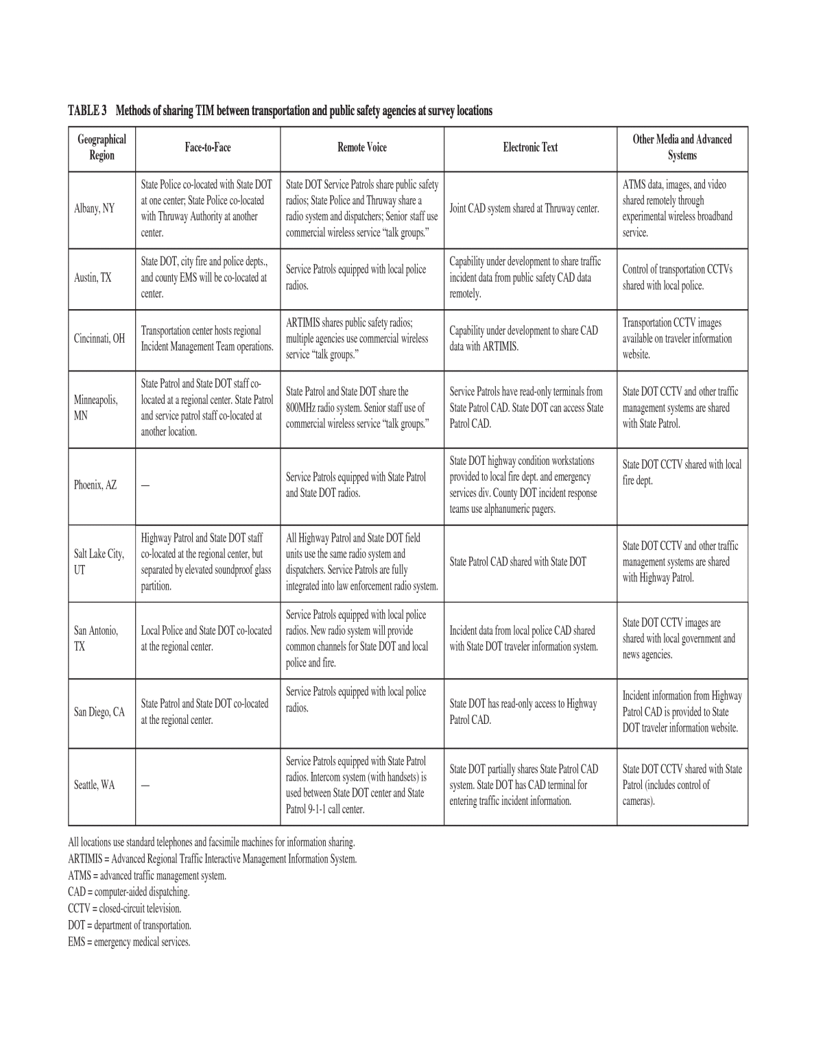
TABLE 3 Methods of sharing TIM between transportation and public safety agencies at survey locations Geographical Region Face-to-Face Remote Voice Electronic Text Other Media and Advanced Systems Albany, NY State Police co-located with State DOT at one center; State Police co-located with Thruway Authority at another center. State DOT Service Patrols share public safety radios; State Police and Thruway share a radio system and dispatchers; Senior staff use commercial wireless service âtalk groups.â Joint CAD system shared at Thruway center. ATMS data, images, and video shared remotely through experimental wireless broadband service. Austin, TX State DOT, city fire and police depts., and county EMS will be co-located at center. Service Patrols equipped with local police radios. Capability under development to share traffic incident data from public safety CAD data remotely. Control of transportation CCTVs shared with local police. Cincinnati, OH Transportation center hosts regional Incident Management Team operations. ARTIMIS shares public safety radios; multiple agencies use commercial wireless service âtalk groups.â Capability under development to share CAD data with ARTIMIS. Transportation CCTV images available on traveler information website. Minneapolis, MN State Patrol and State DOT staff co- located at a regional center. State Patrol and service patrol staff co-located at another location. State Patrol and State DOT share the 800MHz radio system. Senior staff use of commercial wireless service âtalk groups.â Service Patrols have read-only terminals from State Patrol CAD. State DOT can access State Patrol CAD. State DOT CCTV and other traffic management systems are shared with State Patrol. Phoenix, AZ â Service Patrols equipped with State Patrol and State DOT radios. State DOT highway condition workstations provided to local fire dept. and emergency services div. County DOT incident response teams use alphanumeric pagers. State DOT CCTV shared with local fire dept. Salt Lake City, UT Highway Patrol and State DOT staff co-located at the regional center, but separated by elevated soundproof glass partition. All Highway Patrol and State DOT field units use the same radio system and dispatchers. Service Patrols are fully integrated into law enforcement radio system. State Patrol CAD shared with State DOT State DOT CCTV and other traffic management systems are shared with Highway Patrol. San Antonio, TX Local Police and State DOT co-located at the regional center. Service Patrols equipped with local police radios. New radio system will provide common channels for State DOT and local police and fire. Incident data from local police CAD shared with State DOT traveler information system. State DOT CCTV images are shared with local government and news agencies. San Diego, CA State Patrol and State DOT co-located at the regional center. Service Patrols equipped with local police radios. State DOT has read-only access to Highway Patrol CAD. Incident information from Highway Patrol CAD is provided to State DOT traveler information website. Seattle, WA â Service Patrols equipped with State Patrol radios. Intercom system (with handsets) is used between State DOT center and State Patrol 9-1-1 call center. State DOT partially shares State Patrol CAD system. State DOT has CAD terminal for entering traffic incident information. State DOT CCTV shared with State Patrol (includes control of cameras). All locations use standard telephones and facsimile machines for information sharing. ARTIMIS = Advanced Regional Traffic Interactive Management Information System. ATMS = advanced traffic management system. CAD = computer-aided dispatching. CCTV = closed-circuit television. DOT = department of transportation. EMS = emergency medical services.
Traffic Management Center (RTMC) in April 2003. There are workstations located in the RTMC control room for free- way operations, police dispatch, maintenance operations, and traffic news media. MnDOT and MSP share an 800-MHz radio communica- tions system. Working with MnDOT, MSP is deploying nine transportation operations communications centers throughout greater Minnesota (five operational with four coming on-line). These centers serve as communication hubs for emergency response, maintenance operations, traffic management, and traveler information. 3.1.5 Phoenix Through a variety of initiatives, Arizona DOT, Maricopa County DOT, and the Phoenix Fire Department have all tried to enhance TIM through information sharing. Methods of information sharing include shared radio systems, direct phone lines, traveler information workstations, facsimile, alphanu- meric pagers, and CCTV images. Relative to the other loca- tions surveyed, there is a limited amount of actual information sharing between public safety and transportation agencies. Institutional issues are the primary factors limiting information sharing. 3.1.6 Salt Lake City Information sharing between Utah DOT (UDOT) and Utah Highway Patrol (UHP) in Salt Lake City is beneficial, persistent, and effective. Relationships between the two com- munities are mutually reinforcing and are exemplified by the good fit between the two communities at all levels. UDOT was able to take advantage of the Winter Olympics event being held in Salt Lake City to upgrade many of its systems and operations to a high degree of readiness. Also, much of the technical integration challenges were avoided by incor- porating UDOT and UHP into the same radio communica- tions and CAD systems. Information sharing between UDOT and UHP is primarily accomplished within the CAD system; however, highway CCTV imagery is used by both agencies at the traffic operations center. UDOT and public safety field personnel are tightly integrated and work exceptionally well together at the scene of highway incidents. 3.1.7 San Antonio Much of the success of TIM functions in the San Antonio metropolitan area can be attributed to (1) the strong institu- tional structures that have underpinned development and operation of data and communications systems and (2) joint planning and training activities. Critical to the institutional framework is the corridor management team (CMT), which provides an unofficial and informal platform to discuss traf- 9 fic operations. CMT membership consists of representatives from the Metropolitan Transit Authority, the San Antonio Public Works Department, Alamo Dome, the San Antonio Police Department, the Bexar County Sheriffâs Department, EMS providers, towing and recovery service providers, and county health agencies. TIM operations in the San Antonio metropolitan area have further benefited from the TransGuide Operation Center, which has been specifically designed to provide a central point of coordination in responding to emergencies for TxDOT and the San Antonio Police Department. This center has also provided a platform to share voice, data, and multimedia com- munications among multiple responders. Methods of infor- mation sharing include co-location in the operations center, a shared radio system, a trunked radio system, a CAD-traveler information system, and CCTV images. 3.1.8 San Diego California DOT (Caltrans) and the California Highway Patrol (CHP) have demonstrated a commitment to manage traffic incidents cooperatively. To support incident man- agement functions, the two agencies developed an interface between CHP and Caltrans through the San Diego Regional Computer Aided Dispatch Interconnect (InterCAD) project. Although development and implementation of InterCAD was not deemed a success, many technical and institutional lessons were learned from the project. These lessons learned will be critical as both agencies remain committed to sharing infor- mation and may embark on a similar project in the future. Methods of information sharing include co-location in the operations center and a âsanitized CAD systemâ that enables Caltrans to enter details into a record external to the CHP CAD system. 3.1.9 Seattle The Washington State Legislature, the Washington State Patrol (WSP), and the Washington State Department of Transportation (WSDOT) share a common focus to reduce congestion on roadways in Washington State through coor- dinated and cooperative incident management. As a result, both agencies are able to make decisions internal to their own agencies to provide the foundation that ultimately supports information sharing between the two agencies. Leadership and support of decision makers enables those responsible for TIM to focus their efforts on improving safety and mobility in the Seattle metropolitan area through the sharing of infor- mation. As a result, WSP and WSDOT have demonstrated an ability to collectively develop and implement advanced tech- nologies to support coordinated and cooperative interjuris- dictional and interdisciplinary communications in the context of TIM. Methods of information sharing include an intercom system between the WSDOT center and the WSP call center,
a common radio system, CAD integration with traveler infor- mation system, and CCTV images. 3.2 METHODS USED IN PRACTICE 3.2.1 Face-to-Face At six of nine locations surveyed, communications and information systems are made accessible to both public safety and transportation at a common location. These joint opera- tions centers are often the cornerstone for information shar- ing between agencies in a region. As would be expected in jointly operated facilities, the primary method of information sharing is face-to-face voice communications. Face-to-face communication is an effective way of sharing incident noti- fication and status information and for coordinating response and management of the traffic incident or other emergencies. For example, the control room in the San Diego center is specifically designed to foster interaction by arranging con- soles in a manner that facilitates operator-to-operator con- tact. This arrangement has proven especially beneficial as it provides the opportunity to communicate openly between transportation and highway patrol staff as incidents evolve without depending on communications or data systems. Other face-to-face information-sharing methods include on-scene coordination and planning task forces. These are not considered in more detail here. In the case of on-scene coor- dination, this is transitory in nature and common to incident scenes across the United States. Various traffic-planning task forces at some of the surveyed locations provide the basis for coordinated incident management, but are not directly involved in the real time sharing of incident detection, response, or scene management information. 3.2.2 Remote Voice The standard wireline telephone is still the primary means of interagency communication, incorporating facsimile. The public switched telephone network is essential and elemental for public safety and transportation information sharing; tele- phone use was explicitly cited as a means of information shar- ing at most survey sites. Portions of most information flows of mutual interest depend on the wireline network, such as 911 call processing and even cellular telephone services. Some locations have established hotlines. For example, the WSP call center and the WSDOT center communicate via an intercom system. This system enables the WSP dispatcher to communi- cate directly with a traffic system operations specialist in the WSDOT center 24 hours a day, 7 days a week. Action on the highway is best and most immediately described via land mobile radio, as is evidenced by its near universal use by transportation and public safety agencies. However, in most situations, field personnel from one agency cannot talk directly by radio to counterparts from other agen- cies. Public safety agencies, particularly law enforcement 10 agencies, can be reluctant to allow other organizations access to their communications or information-processing systems. However, as these systems have evolved over recent years, they have incorporated sufficient security safeguards to safely permit access and use by personnel who are not sworn law enforcement officers. Modern systems are therefore usually not a significant security problem, although older systems can pose difficulties. In either case, transportation personnel who are granted access privileges to law enforcement sys- tems containing sensitive information are usually required to pass a background investigation. Where permitted and prac- ticable, such joint system use has been shown to improve the efficiency of all users. It has also been shown to improve responder safety. A simple wanted-vehicle check can warn a service patrol operator to avoid contact with a wanted vehi- cle, where assistance might have been previously offered. This check could avoid jeopardizing a service patrol crew or inadvertently aiding a perpetrator. Public safety radio systems were shared with some parts of transportation agencies at most locations. This was done with full transmit and receive units or with monitoring scan- ners. Service patrol vehicles often were equipped with pub- lic safety radios and had access to certain channels. Service patrols are usually sponsored by state or local transportation agencies and offer motorist assistance to vehicles traveling on limited-access public roadways. Service patrol access to public safety radios provides dual benefits. The service patrol operators can be directed to minor incidents by public safety dispatchers, allowing public safety responders to handle more pressing emergencies. Service patrol operators frequently arrive first at serious incidents and can best be the eyes and ears of public safety via direct radio contact (while the public safety responders are en route). At their operations centers, the agen- cies also monitor each otherâs relevant radio communications. Service patrol operators in Seattle, Washington, are equipped with hand-held state patrol radios that enable the operators to communicate with officers responding to an inci- dent. Use of the WSP radio also enables WSDOT to commu- nicate with local fire departments via a common frequency. The fire channel is programmed to communicate only mobile unit to mobile unit. Service patrol operators or vehicles in each of the case study locations were equipped with public safety radios. In the Salt Lake City, Minneapolis, and New York Thruway regions, all state troopers and transportation field units share a common radio system. San Antonio, in cooperation with Bexar County, is in the process of deploying a new trunked- radio system in late 2003 to support public safety operations throughout the city and county. Once implemented, this sys- tem will provide a common frequency for San Antonio Police, San Antonio Fire Department, and TxDOT to communicate in the field while managing traffic incidents. Until recently, radio systems and cellular telephone ser- vices were quite far apart in capabilities, and cellular could not replace radio. Lately, cellular capabilities have improved
so much that they have almost equaled radio capabilities. Key personnel from some of the agencies can coordinate with points of contact at other agencies (and within their own agency) via commercial wireless push-to-talk networks. 3.2.3 Electronic Text Alphanumeric pagers, cellular short message service text messaging, and email are used by some individuals to com- municate within their agencies. However, these applications are not the key means for sharing TIM information with other agencies. CAD systems, while also not yet a key method for inter- agency information sharing, have become a component of incident information-sharing networks in six locations. CAD systems provide automation support for tracking incidents or other events and resources allocated to the emergency scene. Each transaction is logged into a database and available for later retrieval and analysis (as required by law for certain agencies and jurisdictions). Advanced systems include graph- ical maps, the ability to locate vehicles automatically, and mobile data terminals in vehicles. Such information sharing, at present, is primarily in the form of text messaging. Depending on local interpretations of security restrictions, such access may range from a limited and filtered read-only stream of incident status information to nearly the level of access enjoyed by law enforcement officers. A CAD termi- nal may be deployed out to the transportation agency, or a transportation system terminal may be placed in a public safety facility. The San Antonio Police Department (SAPD) can provide TxDOT with incident data through an interface between SAPDâs CAD system and the TransGuide traveler information system. For many years, WSP has provided incident data to WSDOT via a WSP CAD terminal located in the Northwest Region Traffic System Management Center. In San Diego, Caltrans receives incident data output from the CHP CAD sys- tem. Salt Lake Cityâs incident response teams have nearly fully functional CAD terminals in their vehicles (along with radios compatible with the law enforcement radio system). Security considerations are paramount when sensitive com- munication and information-processing systems are used, particularly by people who are not sworn law enforcement officers or even members of law enforcement agencies. The implications can be daunting from the standpoint of human resources management. Transportation personnel may be required to undergo background investigations, have spe- cialized training, and be exposed to greater personal and pro- fessional risk than might have been originally expected. And, even with as much preparation as might be imagined, trans- portation responders may still be prevented from participat- ing in certain incidents and be subject to information restric- tions. This possibility could be due to risks to responders, criminal justice considerations, or homeland defense intelli- gence considerations. 11 In an unusual, but effective arrangement, New York State Thruway Authority funds and operates a joint CAD system with the New York State Police (Troop T) that patrols the Thruway. Thruway Authority personnel dispatch Troop T officers for all traffic-related operations and emergency events. However, there are criminal justice activities and other law enforcement functions that Thruway staff are not authorized to perform. State police staff, also located at the Thruway center, handle all nontraffic calls and coordinate law enforcement activities with other public safety agencies. Incorporating all of the combined public safety and trans- portation users into the same CAD system obviously avoids the technical integration headaches that integrating separate systems would bring. Most existing CAD systems are proprietary and are not designed to exchange information with CAD systems offered by other vendors, let alone with transportation systems. Addi- tional challenges are posed by variations in formats and pro- tocols for data and for messaging and by variations in system standards in the transportation and public safety communities. The USDOT launched two projects in 2003 to demonstrate that the technical and institutional barriers to public safety and transportation system integration can be overcome. It is expected that exchanges between these resources will allow equipment and personnel to be more efficiently deployed, incidents to be more quickly resolved, and traffic to be more safely managed. Some public safety agencies, such as the CHP, are already publicly posting real-time traffic incident information from their CAD systems. For example, live updates of traffic incidents from the CHP CAD are posted on the World Wide Web (2). 3.2.4 Other Media and Advanced Systems Transportation and public safety agencies in most regions employ a wide range of surveillance and communications technologies. The traveler information and traffic manage- ment systems operated by transportation agencies in many metropolitan areas include CCTV or other video systems, embedded sensors in roadways, variable message signs, and highway advisory radio systems. Information generated by these systems is useful for detecting and responding to inci- dents, managing traffic, and informing the traveling public. Traveler information and traffic management systems are designed to provide information to the general traveling pub- lic regarding road and traffic conditions. Features of these sys- tems make it easier for the traveler to determine his or her loca- tion, the best route to take to reach a chosen destination, and the travel conditions along the route. Public safety also has a frequent need to travel quickly and efficiently from one loca- tion to another using the same roadway system. Many features and services provided by transportation and traffic manage- ment systems can therefore also benefit fire and rescue, law enforcement, and EMS while responding to calls. Traffic man- agement services can provide valuable information regarding
real-time traffic congestion, road conditions, and the situation at the scene of an incident. Even though public safety person- nel may be familiar with the road geography of the jurisdic- tion, they may be less so of surrounding jurisdictions to which they may be called when an incident escalates beyond the capabilities of local responders to handle. This is especially true for major incidents and disasters that may require state, regional, or federal response from a long distance. TIM has embraced the advanced information formats offered by the Internet and other modern information systems. Some of the data, such as video and still images, are shared between agencies through co-location and remote access to the systems. However, most agencies make imagery available to the public through the Internet; some provide low-bandwidth âsnapshotâ frame captures of highway CCTV camera video, and some provide streaming video. Dynamic, interactive map- ping displays are commonly used to portray the overall traffic situation for metropolitan areas, linked to detailed informa- tion for each trouble spot. This multilayered information is ideally formatted for quick and easy use, providing simulta- neous summary, brief descriptions, and detailed information for the traveler. The stratification of this information fits well with TIM, where top-level managers want the big picture and task leaders need detailed and specific information. The Arizona Department of Public Safety (DPS) has High- way Conditions Reporting System (HCRS) workstations in three dispatch centers statewide. These workstations enable the Arizona DPS to directly input information about roadway closures or any other circumstances affecting the operations of state highways. WSDOT currently operates more than 250 CCTVs through- out the Seattle metropolitan area. Through an operational agreement, WSDOT provides WSP with the images from these cameras. In addition, WSDOT provides WSP with sec- ondary control of the cameras to enables WSP dispatchers to view the incident scene, verify incidents, and dispatch addi- tional officers if needed. The TxDOT-operated TransGuide system includes CCTVs that are implemented on 73 miles of freeway throughout the metropolitan area. Although TxDOT maintains control of the 12 cameras, video images are disseminated to the media and to the San Antonio City Hall via the City of San Antonio Wide Area Network (WAN). In addition, TransGuide shares video with other emergency responders, the local media, and the general public by broadcasting live video over a 1,000-watt Low Power Television (LPTV) system (3). This system pro- vides up to four views that are selected by the TransGuide operations staff. This system can also be used by incident responders to assist in determining what equipment and vehi- cles are the most appropriate for the response. The new regional center in Austin will enable police dis- patchers to view monitors showing CCTV images. Dispatch- ers will have control of the cameras when TxDOT personnel are not present. Through an agreement with Arizona DOT, Phoenix Fire Department dispatchers receive video images that are shown on monitors in the dispatch center. Although rights to control the pan-tilt-zoom functions of the cameras are not defined in a formal agreement, dispatchers are able to control the cam- eras. Dispatchers primarily use the information to provide responders with closure information that helps to foster a more expedient response. In the Salt Lake City, transportation operations center, either UDOT or highway patrol dispatchers can control CCTV systems during significant incidents. DOT staff have more experience and usually accomplish this task during the hours they work at the center. Broadband technologies enable high-speed communica- tions. The USDOT ITS Joint Program Office partnered with Albany region agencies to demonstrate the benefits of such high-speed communications for traffic management opera- tions (4). The network supported simultaneous interchange of voice, data, and video services in a cost-effective manner. Data encryption was established by the wireless component, and a firewall was added to provide access control and authen- tication. This prototype system allowed cross-agency sharing of freeway management system information and video feeds and enabled video teleconferencing, direct audio feed from radio systems, and dedicated telephone âhotlinesâ (5).
