


Below is the uncorrected machine-read text of this chapter, intended to provide our own search engines and external engines with highly rich, chapter-representative searchable text of each book. Because it is UNCORRECTED material, please consider the following text as a useful but insufficient proxy for the authoritative book pages.
17-1 17 â Transit Oriented Development OVERVIEW AND SUMMARY Transit oriented development (TOD) generally refers to higher-density development, with pedes- trian priority, located within easy walking distance of a major public transit station or stop(s). TODs are viewed as offering the potential to boost transit ridership, increase walking activity, mit- igate sprawl, accommodate growth, and create interesting places. This chapter focuses on the TOD land use strategy and its transportation impacts. It is complementary with Chapter 15, âLand Use and Site Design,â and does not seek to duplicate general information on the impacts of density, diversity, and site design presented there. Similarly, it is not intended to cover the same ground as Chapter 16, âPedestrian and Bicycle Facilities.â Chapters 15 and 16 should be referred to for addi- tional background on density, land use mix, site layout, and pedestrian-friendly design effects on travel demand. This âOverview and Summaryâ section includes: ⢠âObjectives of Transit Oriented Development,â highlighting the key reasons planners pursue TOD. ⢠âTypes of Transit Oriented Development,â outlining what constitutes TOD and the various dimensions along which response to it may vary, primarily for purposes of chapter organization. ⢠âAnalytical Considerations,â identifying approaches that are used to evaluate the impacts of transit oriented development and discussing their potential limitations. ⢠âTraveler Response Summary,â providing an encapsulization of travel behavior findings detailed in the remainder of the chapter. Following the âOverview and Summaryâ are sections on: ⢠âResponse by TOD Dimension and Strategy,â providing coverage on traveler response to TOD along the various dimensions identified for organization of discussion. ⢠âUnderlying Traveler Response Factors,â examining attributes and mechanisms found or thought likely to be responsible for travel demand sensitivities to TOD. ⢠âRelated Information and Impacts,â presenting information on a broader range of related areas of interest including example TOD characteristics, concerns, and success factors. ⢠âCase Studies,â expanding on selected examples of TODs and TOD analyses.
The Handbook user should be sure to review the next three subsections of this âOverview and Summaryâ before proceeding to utilize either the âTraveler Response Summaryâ subsection or the remainder of this chapter. Objectives of Transit Oriented Development TOD projects potentially involve a wider variety of stakeholders than other development projects, reflecting in part the more extensive involvement of transit agencies and government funding sources. TOD stakeholders may have a wide range of complementary or competing objectives. Travel-related objectives include: ⢠Increasing the opportunities for residents and workers to meet daily needs by taking transit or walking. ⢠Attracting new riders to public transit, including so-called âchoiceâ ridersâriders who could otherwise choose to drive. ⢠Shifting the transit station mode of access to be less reliant on park-and-ride and more oriented to walking. ⢠Reducing the automobile ownership, vehicular traffic, and associated parking requirements that would otherwise be necessary to support a similar level of more traditional development. ⢠Enhancing the environment, through reduced emissions and energy consumption derived from shifts in commuting, other trip making, and station access to environmentally friendly travel modes. Non-transportation objectives may include providing desirable and affordable housing choices, enhancing sense of community and quality of life, supporting economic development or revital- ization, shifting development from sensitive areas, minimizing infrastructure costs, and reducing sprawl. Financial return is among the motivating factors for at least some of the stakeholders, including, in some cases, the transit agencies involved. Rents, for example, are potentially a significant source of non-farebox revenue accruing from development on system-owned land adjacent to transit stations (Cervero et al., 2004). This chapter is primarily concerned with the travel behavior effects of TOD and thus affords only limited attention to non-transportation objectives. Types of Transit Oriented Development The term âtransit oriented developmentâ is imperfect in its ability to fully characterize the nature of a project. Generally speaking, TOD refers to moderate-to-high-density development, designed with pedestrian priority, located within an easy walk of a major transit stop. Typically TODs have a resi- dential emphasis, or a significant residential component, and preferably feature a mix of residential, shopping, and employment opportunities. An alternative, promoted by some, is to provide part or all of the mix in a string of separate TODs an easy transit ride apart. For those to whom the term implies only ânewâ (post-modern) development, TOD can be new construction or redevelopment of one 17-2
or more buildings whose design and context facilitate transit use. Others apply the term to any neigh- borhood, irrespective of its era, that exhibits a satisfactory array of TOD-like physical and transit ser- vice characteristics. The âtransit oriented developmentâ term appears to have replaced âtransit-focused development,â perhaps to better characterize transit in a supporting rather than a starring role. The related term âtransit joint developmentâ generally refers to development in which the transit agency is a land owner or major participant in the financing of the project. This term relates more to the project financials than development characteristics. More recently, the term âtransit-adjacent develop- mentâ has emerged as an analytical and sometimes derisive descriptor of projects that are located near transit nodes but do not embrace or take full advantage of their proximity to transit (Cervero, 2003). There is substantial interest in identifying markers of successful TOD. This interest applies not only to evaluation assessments of existing TOD examples, but also especially to forward-looking design guideline, regulatory, and forecasting applications. Introduced at the conclusion of the âRelated Information and Impactsâ section of this chapter is the concept of a âTransit Oriented Development Indexâ as a potential device for considering the degree to which a particular project is intrinsically oriented toward transit. TOD Dimensions For purposes of organizing this synthesis of the TOD literature the Handbook authors have chosen to look along three dimensions that significantly characterize TODs. The selected dimensions are: regional context, land use mix, and primary transit mode. Following are brief descriptions of each of these dimensions. The traveler response effects along each are explored in the âResponse by TOD Dimension and Strategyâ section. Regional Context. TOD may exist in a long-established city center or in a suburban context. Although locating TOD in either area type may result in boosted transit ridership and increased walking, the regional context plays a role in determining the overall traveler response. City center TODs generally have higher levels of transit service to more travel markets than subur- ban TODs and consequently have higher transit ridership generation potential. However, the difference TOD represents from the status quo in suburban contexts is likely more pronounced than in city center contexts, one of the reasons suburban applications receive more attention in the literature. Land Use Mix. TODs come in a variety of flavors with different mixes of office, retail, and residential space. The travel behavior response to TOD may be influenced by the type and quantity of uses present. For example, TOD that enables its occupants to address daily needs within the project may result in fewer automobile trips and lower automobile ownership rates than less diverse TOD. Primary Transit Mode. TOD has been planned or constructed around rail and bus transit stations and stops. Modal characteristics may factor into both the development feasible at the station and the ability of public transit to serve the travel markets created by the TOD. Although TOD around stations of light rail transit (LRT) and heavy rail (rail rapid) transit (HRT/Metro) is the most prominently discussed in the literature, TOD can also be served by commuter rail (CRR), bus rapid transit (BRT), and good-frequency traditional bus services. 17-3
Analytical Considerations A variety of considerations need to be weighed when using or interpreting the findings reported in this chapter. These considerations include the size and nature of the samples surveyed or investigated, the use of control groups, the definition of TOD, and the difficulty of isolating causality of the effects under study. When working with the findings, their significance should be assessed in the context of these considerations. Key TOD travel characteristics studies have had difficulty achieving adequately large and reliably representative samples of survey respondents. Low survey response rates introduce a greater potential for self-selection bias among the individuals from whom survey responses are obtained. As the response rate declines, the confidence that one can place in the results and their transferability declines as well. Regrettably, the phenomenon of low response rates has become more common among travel behavior surveys as sampling costs have increased and subject willingness has decreased. TOD resident and visitor/worker surveys have been particularly affected. Sample rates are reported here, where available, to enable the reader to make an informed evaluation of likely findings reliability. Several studies rely on Census data as the source of baseline comparisons in lieu of having collected study-specific control group data. Although this approach can save on data collection costs, it yields a data set in which baseline (Census) survey procedures are likely not fully comparable to the TOD survey procedures, rendering survey process effects and differential sample biases more likely and harder to assess. Moreover, it builds any limitations in the Census survey instrument into the study findings, including the fact that the Census has only asked travel questions about the Journey to Work. The 2000 Census survey instrument asked about the âusualâ mode of travel to work rather than the mode used on a specific day, which leads to under-reporting of transit use by occasional users and over-representation of transit use by not-quite full-time users. Caution should be exercised in directly transferring the results from one application or experience to another situation. This may be especially critical in the case of TOD, where few before-and-after data-driven studies exist, and a large proportion of the quantitative findings derive solely from California and Portland, Oregon, data. The notable differences illustrated by the relatively stronger LRT-based TOD travel demand effects encountered in Portland compared to weaker LRT-based TOD effects assayed in certain California locations, and the stronger HRT-based TOD effects in the San Francisco Bay Area compared to Los Angeles, deserve attention. It is helpful that these differences mark out broad ranges within which many potential TOD applications nation- wide should fall. As is evident in the âTypes of Transit Oriented Developmentâ discussion it is impossible to develop a simple litmus test for what is or isnât TOD. As a result, many studies look at adjacency to transit as a surrogate measure. Survey and study results for residents or workers located proximate to transit within various manifestations of TODs and other transit-adjacent development may be lumped together. Inconclusive findings regarding TOD travel impacts or TOD success may in part derive from including travel behavior and related outcomes observed in transit-adjacent constructs that do not possess critical elements generally perceived as being essential characteristics of good TOD (Hendricks, 2005). 17-4
Researchers have noted the interactive nature of various factors, not all transportation-related, that influence the effectiveness of TOD in altering travel behavior. Different characteristics of the travel experience may relate to urban form, urban design, and transit service variables in a synergistic man- ner. In isolation they may not have the same effect as they do together (Hendricks, 2006). These dynamics, in combination with the huge variety of TODs and other forms of transit-adjacent devel- opment, make it quite difficult to sort out the details of causality: What is it exactly that produces observed phenomena such as higher transit use in proximity to transit stations? High-density, mixed- use development and high levels of transit service are often present together at sites exhibiting a high transit commute mode share and a high midday non-motorized mode share. Unknowns involving causality make it difficult to separate the contribution of each site element to the resulting transit and pedestrian activity (Douglas and Evans, 1997). Involved is not only the question of what factors are at play, but also the issue of direction of causal- ity. For example, is observed lower auto ownership within TODs the result of TOD characteristics leading residents to own fewer autos or the result of families with lower auto ownership actively choosing to live in TODs? The following additional examples are only a small sampling of causality- related analytical problems from among the many that make TOD travel-demand effects analysis particularly challenging. External factors may in part be the cause of observed travel demand changes. Much of the TOD research cited in this chapter was carried out in recent years. The mid-years of this period coincided with an economic downturn across the United States that resulted in somewhat less commuting in most markets. Ridership on many transit systems dropped during the period. These events followed an earlier period of growing transit ridership which coincided with an economic boom and height- ened gas prices. As a result, the findings from some studies may be clouded by external economic influences (Pucher, 2002). There is always the possibility of various unreported confounding factors. A few of the cited studies used survey questions asking respondents to isolate the significance of ele- ments responsible for the experience they report. The value of this approach to probing causality is open to question. Sometimes, the combination of factors responsible is difficult for respondents to isolate. For example, respondents may underreport the significance of elements that may be taken for granted but are in fact quite important. Sidewalks are a case in point. They may be taken for granted, but were they not present in a high-density TOD context, the pedestrian friendliness of a street would be dramatically degraded. Likewise open to question are the importance and effects of attitudes relative to TOD attributes in shaping TOD travel behavior outcomes. Resident self-selection and associated attitudinal influences have been a particular concern to some investigators. For further discussion of this particular consideration, see âUnderlying Traveler Response FactorsâââSelf-Selection of Residents.â Still other concerns, in addition to those highlighted above, are relevant in assessment of TOD effects as well as evaluation of any traveler response findings. Chapter 1, âIntroduction,â offers additional perspectives under âUse of the Handbook.â See especially the subsections âHandbook Application,â âDegree-of-Confidence Issues,â âImpact Assessment Considerations,â and âDemographic Considerations.â In view of the uncertainties inherent in traveler response research in general and TOD research in particular, notes are included where appropriate in the main body of the chapter 17-5
to assist the reader in assessing what is less or more reliable. These notes range from informa- tion on survey and analysis conductâfor the reader to weighâto outright questioning or confirmation of likely reliability. Traveler Response Summary TOD concentrates trip generation and attraction around transit stops and stations resulting in more transit ridership per stop, even if one makes the hypothetical assumption that TOD transit mode shares are no higher than produced by conventional development in the same locations. Typically, however, the special attributes of well-designed TOD result in transit shares that are higherâand automobile mode shares that are lowerâthan for non-TOD. This outcome leads to even further elevation of transit ridership levels. With regard to vehicular traffic volumes, the extent to which TOD travel concentrations may result in more local area automobile travel in total depends on the degree of concentration on the one hand and the success in achieving lower auto driver mode shares on the other. Numerical examples of actual transit ridership gains that can be clearly attributed to TOD imple- mentation are few because of the many sources of ridership and multiple confounding factors typically present. One station where TOD or equivalent development is fairly clearly the primary cause of ridership gains is Gallery Place in the old downtown of Washington, DC. Weekday Metrorail boardings at the station grew from 6,500 in 1997 to 10,200 one year later with construction of a transit- oriented sports arena. By 2002, weekday boardings stood at 13,800 after a half-decade of TOD-like redevelopment in the area. An analysis of TOD across the Potomac in Arlington, Virginia, found each 1,000 additional dwelling units together with the effects of Metrorail service increases was associated with 500 new boardings/alightings (roughly 250 boardings and 250 alightings). Similarly, each 1,000 square feet of office/commercial space was estimated to be associated with nearly 500 new boardings/alightings. On a smaller scale, weekday boardings at the Downtown Plano LRT station in the Dallas suburbsâa station with no park-and-ride spacesâgrew from 590 riders in 2003 to 770 in 2006 concurrently with construction and occupancy of nearby TOD. The difficulty of ascribing ridership changes directly to TOD is illustrated by the circumstance that the stationâs 31 percent 3-year growth was bracketed by the 21 and 38 percent 3-year growth experienced at the adjacent auto-oriented stations with no TOD. TODs may be categorized according to regional context, land use mix, and primary transit mode. A broad variety of factors appear to influence the traveler response to TOD including land use and site design, automobile ownership, relative transit and highway accessibility, parking supply, parking pricing, transit support, and evidently self-selection of residents as well. It also appears that the various influences on TOD travel behavior choices are decidedly interactive in nature. These factors are not all transportation-related, suggesting that it takes more than good transportation policy alone to develop high-quality and effective TOD. Density, diversity, and design influence TOD impacts in much the same way that they impact non-TOD land development. Higher densities, greater diversity of land uses, and better design are associated with more transit use and walking and fewer automobile trips per resident and per worker. TOD also facilitates accomplishment of activities within the devel- 17-6
opment itself, on foot or via convenient transit connection, thereby eliminating the need for some automobile trips and helping make auto commuting less of a necessity. In Portland, Oregon, as of 1995, the average central area TOD transit share for non-work travel was roughly four times the transit mode share for outlying TODs, which in turn had over one-and-two- thirds times the corresponding transit share of mostly-suburban, non-TOD land development. The walk and bike non-work central area TOD share for trips produced at the residence was two-and- one-half times the share for suburban TODs (but essentially equal for trips attracted to commerce and other activities), while suburban TODs had roughly twice the walk/bike share of non-TOD areas. The auto mode share for trips produced at the residence in downtown TODs was 70 percent of the comparable share at suburban TODs, and the suburban TOD auto share was approximately 90 percent of the non-TOD auto share. The influence of socio-economic factors relative to land use design in producing these effects has not been quantified. Similar data for Portland work-purpose trips have not been developed. Station-area surveys made in the Washington, DC, region in 2005 show, however, that work-commute transit mode shares decline from 75 percent at downtown office buildings right at Metrorail stations to just over 10 per- cent on average at office buildings within roughly 1/2-mile of a station but located in the suburbs outside of the Capital Beltway. All reported trips by residents of selected residential sites near sta- tions range from an average of 56 percent transit in the downtown to 32 percent transit beyond the Beltway. Whatever the location within the region, however, transit shares were found to increase markedly with closeness to a Metrorail station, a phenomenon also found around rail stations in Chicago, California, and Canada. Transit mode shares along the Washington Metro system were found to decrease by 7 percentage points for every 1,000 feet of distance from a station in the case of housing and by 12 percentage points in the case of office worker commute trips.1 A 2003 California TOD travel characteristics study found TOD office workers within 1/2 mile of rail transit stations to have transit commute shares averaging 19 percent as compared to 5 percent regionwide. For residents, the statewide average transit share for TODs within 1/2 mile of the station was 27 percent compared to 7 per- cent for residences between 1/2 mile and 3 miles of the station. Along Northern Californiaâs BART system, the two sets of HRT TODs reported on had in one case a 38 percent commute trip transit share within 1/2 mile versus a 3 percent share between 1/2 mile and 3 miles, and in the other case a 45 percent share versus 13 percent. The one set of California CRR TODs separately examined showed a 17 percent commute trip transit share within 1/2 mile versus a 5 percent share for areas between 1/2 and 3 miles. The two sets of LRT TODs examined had 13 percent versus 6 percent transit commute shares in one case but 3 percent versus 11 percent (the reverse of that expected) in the other. In the instance where transit commuting was less prevalent within the TOD than further from the station, survey responses on reasons for residential location choice suggested that non-transit attractions of the housing (cost and quality) had overwhelmed and rendered moot the transit service benefits offered, an unusual but apparently not totally unique situation. Quantitative information on BRT and other bus-oriented TODs is extremely limited, but clearly BRT service parameters are comparable to those of many LRT systems. Circa 1990 17-7 1 âPercentage pointsâ refers to an absolute difference in percentages, rather than a relative difference.
peak period transit mode shares at major mixed-use neighborhoods and universities along Ottawa, Canadaâs busway system, for all trip purposes combined, averaged 52 percent transit at three loca- tions directly served by BRT stations and 34 percent at two off-line locations. Over 90 percent of station-area TOD residents surveyed in the 2003 California study reached their neighborhood rail station by walking, a major vehicle trip reduction and air quality enhancement benefit. The greater the concentration of transit trip generation within station areas, the higher a stationâs overall walk access share will tend to be. For example, with the high TOD development densities along Arlington, Virginiaâs Ballston corridor, the Ballston Metrorail station achieved a 67 percent walk access share in 2002 for the 22,000 daily station entries and exits. Chicago area walk access shares for six high ridership Metra CRR stations reported in 2000 were 82 percent at up to 0.5 miles (TOD territory), 41 percent at 0.5 to 1.0 miles, 8 percent at 1.0 to 2.0 miles, and 1 percent at over 2.0 miles. Corresponding drive alone access shares were 8, 33, 53, and 64 percent with increasing distance from the stations. TOD residents are generally associated with lower automobile ownership rates. Reduced auto- mobile availability is important to TOD impactâresidents or workers without access to an auto- mobile are more likely to forgo travel or to make trips on foot or by transit. Auto ownership in three New Jersey âTransit Village Areas,â for example, averaged 1.8 vehicles per household compared to 2.1 outside the transit villages. Corresponding users of transit (at least 10 times per month) rep- resented 25 percent of households inside the transit villages and somewhat over 15 percent of households outside. Supportive policy or planning actions may be able to reduce auto ownership rates further still at certain TODs, achieving additional automobile mode share reduction as a result, or may be able to directly enhance use of alternatives to the auto. The 2003 California study found, for example, that among surveyed workers in TODs the work trip transit mode share was 25 percent for those receiv- ing an employer transit subsidy and 5 percent for workers without this benefit. It is a reasonable but only anecdotally-supported speculation that offering pass programs packaged with residence purchase options or rents may be a useful device for attracting low-auto-ownership, transit-using residents to TODs lacking the advantage of heavy-duty transit services fully competitive with the auto. Relative transit and highway accessibility exert important influences on TOD impacts. The frequent, highly connective transit service associated with most TOD offers a better alternative to automobile usage than the lesser transit service associated with more typical low-density development. Competitive transit travel times and short waiting times are important contributors to transit usage in TODs, just as they are outside the context of TOD. Parking management is also key to TOD traveler response. In the 2003 California study, surveyed TOD office workers were over three times as likely to use transit where parking availability was less than one parking space per two workers as compared to offices with more parking. (Factors other than parking supply alone were undoubtedly at play.) Constrained and priced parking may lead to lower park-and-ride ridership but potentially higher transit mode shares for the development within the TOD. TODs provide a number of parking efficiencies including reduced parking needs and shared parking opportunities. A TOD relationship that is quite poorly established at present is the degree to which TOD can reduce vehicle trips and vehicle miles of travel (VMT) from a regional perspective. The seemingly ideal measure would be the change in travel choices made by individual TOD 17-8
residents when they move and settle in. Only four studies were encountered that provide comprehensive observations in terms of mode share changes made by TOD or other station-area residents, with three of these offering published quantification of overall net changes. The documented and inferred travel mode shifts upon relocation into TODs range from 2 percentage- point or smaller shifts into the transit mode for commuting (average of surveyed California sites, two statewide studies) to 15 or 16 percentage-point shifts to transit commuting (two Portland, Oregon, studies, one providing an 8-site average). The Portland results must be taken in context with Portlandâs highly transit-supportive conditions and medium-sized urban area environment and pertain only to LRT-based TODs. In California, the shifts were larger and more clearly beneficial for the survey subset of residents along the BART HRT system as compared to TOD survey respondents statewide. Taken together with shifts in and out of walk, bicycle, and other modes, the apparent effect on automobile commuting ranged from indiscernibly small effects on average across surveyed California residential sites to an 18 percentage-point drop in auto use found in the 8-site Portland survey. Faced with the uncertainties introduced by this sparse data, reliance must also be placed on mode share comparisons between TODs and non-TOD areas such as those presented earlier in this summary. One of the most clear-cut transportation benefits of TODs is the positioning of large numbers of transit riders close enough to their transit stop that they can and will walk to it in pref- erence to auto use for the access mode. Some reviewers of TOD efficacy have postulated that the higher transit mode shares normally observed in TODs may simply result from attraction of âtransit-orientedâ residents to TOD hous- ing and that the outcome may be a lack of significant increase in transit use when viewed from a region-wide perspective. This overall hypothesis has received the somewhat confusing âself-selectionâ short-hand labeling. Survey findings do indicate that modest proportions of TOD residents have indeed made their housing choice with the good TOD transit use opportunities as one of their top reasons. For there to be no increase in regional transit use, however, the transit usage of such indi- viduals mustâon averageânot change overall. Recent research on the interplay between attitudes and travel choices does not appear to support the likelihood of this part of the proposition. The new research indicates that there are actually greater differences between the travel choices of âurban-orientedâ residents of conventional suburbs and similarly inclined persons residing in TOD-like traditional city neighborhoods than there are between the travel choices of âsuburban- orientedâ residents located in one or the other of these two disparate environments. The cause appears to be inability of urban-oriented residents to act on their preferences and make much practical use of transit and walking within conventional suburbs, whereas it remains inherently feasible for suburban-oriented residents to choose to drive even in highly urban environments. The logical conclusion from this finding is that âtransit-orientedâ residents should not be written off as persons who will use transit and walk with or without TOD benefitsâthey may well be the ones who respond most enthusiastically with shifts away from auto travel when provided with the realistic transit use and walking options that effective TOD offers. Under these circumstances, TOD resident self-selection could actually be a positive force in reducing regional auto travel and enhancing transit ridership. Suggested values for essential indicators of a âTOD Indexâ to describe development project âTOD- nessâ (see also Tables 17-44 and 17-45) include: ⢠Centrally located transit with walking distances no more than 1/4 to 1/2 mile. 17-9
⢠Superior walkability with small blocks and pedestrian traffic management priority. ⢠Extended hours of highly-reliable transit service at 5- to 15-minute intervals. ⢠Land use mix to meet daily needs paired with good transit connectivity to other activities. ⢠Density sufficient to support cost-effective transit, retail services, and infrastructure. ⢠Managed parking with reduced supply relative to standard development. RESPONSE BY TOD DIMENSION AND STRATEGY The focus of this chapter section is on the transit usage and other traveler response outcomes found to be associated with the presence or implementation of transit oriented developments (TODs). The effects along each of three definitional dimensions of TOD, highlighted in the âTypes of Transit Oriented Developmentâ subsection, are examined: regional context, land use mix, and primary transit mode. There is necessarily substantial overlap among these discussions as it is impossible to fully isolate the contribution of each dimension. Three of the travel demand measures often employed to describe outcomes involve different aspects of traveler choice of travel mode. These measures are mode share, mode of access share, and sub-mode share. Mode share (unless explicitly otherwise defined) is a fundamental measure referring to choice of primary travel mode between a tripâs origin and its final destination. For example, a trip starting with driving alone to a commuter rail (CRR) station, followed by a train ride terminating 1/2-mile from the final destination, and concluding with walking to get there, would be classed as a commuter rail trip for purposes of mode share calculation. A mode share proportion is expressed as a percentage of all travel by all modes (including walking and bicycling) in the travel category of interest or, mainly in older studies, all travel by motorized modes only. Also of frequent interest, especially to local area traffic, parking, and environmental concerns, is mode of access share. This share describes the proportions among means of getting to and from the primary mode. The access and egress modes in the example just given would be the drive-alone (to the station) mode of access and the walk (from the station) mode of egress. Less often encoun- tered is sub-mode share, the proportion of transit trips using a particular form of transit, such as local bus or heavy rail transit (HRT). A true sub-mode share is expressed as a percentage of all transit travel. Note that the ârailâ and âbusâ mode shares within mode share tables in this chapter are cal- culated in the manner of primary mode shares, not sub-mode shares, because they are expressed as percentages of travel by all means and presented in context with modes of all types. These tab- ulated rail and bus mode shares may be summed to obtain transit mode shares, a calculation not supported by true sub-mode shares. Response to TOD by Regional Context Many articles discuss TOD as a suburban strategy. Possibly this is because it is harder to apply the âTODâ label to city center development that fits into an existing pattern. Also, perhaps the subur- ban interest reflects growing developer awareness of the market potential for suburban TOD and the contrast that TOD represents in terms of a departure from the status quo of suburban sprawl. While city center TOD may attract more transit riders in total, suburban TOD may represent greater potential change. 17-10
Attributes associated with the regional context of a TOD strongly influence the travel behavior response. City center TOD is more likely to be accessible to a larger potential transit market than is suburban TOD. City center TODs may have transit services radiating in multiple directions. Suburban TODs tend to be located along radial transit services and thus only have high quality service available in one or two directions. In addition, it is more likely that activities can be accom- plished by walking or transit in the urban context than in the suburban context, especially in early- stage TODs. Table 17-1 highlights contrasts between the two regional contexts. 17-11 Suburban ContextCity Center Context Transit Markets Urban sites are often directly accessible to and from multiple transit markets. For example, Gallery Place Metro station in Washington, DC, is fed by three rail lines originating from five different suburban areas and passing through different downtown areas, all offering one-seat rides to the station. Markets served by high-quality transit service may be limited. For example, Ballston Metro station in Arlington, Virginia, is fed by a single east-west rail line originating from two suburban areas. Other transit riders from around the metropolitan area must transfer to arrive at the station and/or use bus service. Drive Markets Highway accessibility remains important to the urban real-estate market. Automobile-oriented commuting is prominent even in the most transit accessible locations. Mode of access to suburban transit station developments tends to remain dominated by the automobile and therefore automobile accessibility is of substantial importance. Parking Management It may be more acceptable to constrain and manage parking in downtown areas, especially by using pricing. Constrained parking leads to higher transit attractiveness. People may own fewer cars in central areas due in part to good transit service availability and easy walking access to utility retail. It may be difficult to manage parking; the suburban real estate market may dictate parking space ratios that are higher-than- optimal for transit. Examples abound where developers build more parking than is required. Also, higher rates of automobile ownership among residents are present. Phasing Effects Existing nearby land uses may support a TOD project in reducing single- occupant vehicle usage for midday trips. Alternatively, nearby legacy development may retain automobile orientation and dampen the behavior impacts of adjacent TOD. Neighborhood services supportive of non- automobile, non-work travel may not pre- exist. Thus, until such uses are part of the TOD, the early phases of a new TOD may exhibit higher automobile mode share than the later phases of a more mature TOD. Table 17-1 Perspectives on TOD as Differentiated by Regional Context City Center TODs City center TOD adjusts the focus of transit-accessible urban development to increase tran- sit ridership and to encourage pedestrian activity. Some aspects of the city center, such as grid street patterns and ground-level retail uses, are attributes usually shared with TOD.
However, city center TOD often addresses the office-domination represented in the existing land use mix by introducing housing and other non-daytime uses. It is also usually constructed with less parking than traditional development to better encourage transit use. City center TOD tends to be less discrete than suburban TOD in that it may comprise several projects over multiple blocks. While there are many examples of city center TOD, virtually none provide a case where comprehensive and specific development, transit service, and traveler response information has been documented. In general terms, it is reported that these projects have increased transit ridership, encouraged pedestrian activity, and have required less parking than more traditional projects (Costello, 2003). Two of the better-documented examples follow. Washington, DC. A transit-oriented downtown sports arena was constructed at the Gallery Place Metrorail HRT station in Washington, DC, opening in December 1997. The 20,000 seat venue was built to allow the professional hockey and basketball teams to transfer from their suburban location to downtown. Whereas at the suburban location virtually everyone drove to the facility, the new arena has a transit mode share of over 50 percent for events. Transit ridership was encouraged by constructing an enhanced station entrance and by building virtually no patron parking on-site. Comparing average 1997 weekday boardings at the Gallery Place station to 1998 boardings shows a 56 percent increase (6,525 to 10,179). During the same period, systemwide weekday ridership increased by just under 5 percent, including the effect of one new station. The area around the arena, part of the old downtown, has since become a revitalized retail and entertainment district. In addition, several residential and office projects have been constructed nearby. Correspondingly, from 1998 to 2002, average weekday boardings at Gallery Place grew 36 percent above the 1998 level (to 13,833) versus just under 20 percent for the system as a whole, including the effects of adding 8 more new Metrorail stations (Costello, 2003; WMATA, 2002). In the subsequent 4 year period, from 2002 to 2006, the Gallery Place weekday ridership growth was almost 50 percent (to 20,673) compared to 13 percent for the system (to 714,953 with 3 more stations) (WMATA, 2006b). Denver, Colorado. In Denverâs city center, ridership growth has occurred in parallel with TOD and transit system expansions, including the introduction of light rail transit (LRT) to downtown. Much of the development has involved converting former office and industrial buildings to mixed use or residential use, with more than 50 formerly derelict structures put back into service as of 2003. In addition, transit-supportive policies such as parking maximums and encouragement of ground-level retail have been employed. The population in the downtown has grown from about 1,000 to 2,500 with an accompanying increase in median income. Average weekday transit ridership on the 16th Street Transit Mall free bus shuttle was reported in 1997 to be 45,000 daily riders.2 In 2004, following both the introduction of riders from a second LRT line and an extension of the transit mall shuttle service to reach residents of the Central Platte Valley redevelopment, mall bus ridership was reported as 60,000 daily riders. Transit mode share for work trips to the downtown core is reported to have increased from 20â25 percent up to 35 percent during this critical period of downtown Denverâs revitalization. More than 10 percent of the regionâs workforce is employed in downtown and almost half of these workers commute either via bus or rail transit or by ridesharing. The separate contributions to the ridership and travel behavior 17-12 2 A circa 1997 traveler response review of the Denver transit mall bus shuttle is provided in Chapter 10, âBus Routing and Coverage,â under âResponse by Type of Service and StrategyâââCirculator/Distributor RoutesâââTransit Terminal and Parking Distributors.â
changes attributable to LRT expansion, transit mall shuttle extension, and TOD and other development have not been isolated (Cervero et al., 2004; Costello, 2003; Ohland, 2001; Project for Public Spaces, 1997). Suburban TODs Some suburban TODs are built on undeveloped land at new or existing transit stations. Other such TODs are built on land previously used for surface parking lots. TOD has become viable on these suburban park-and-ride lot sites in part because metropolitan areas have expanded outward beyond the ends of the rail transit lines. However, there can be conflict between the use of the station area as a destination for park-and-ride transit users and its use as a place for people to live or work in the replacement development. Complicating matters are the requirements of suburban TOD for better highway access and greater accommodation of parking for tenants than needed for city cen- ter TOD, along with the mandates of many transit agencies for replacement of any park-and-ride parking removed for development purposes. Providing large amounts of parking has implications for both development economics and traveler behavior. Indeed, balancing the provision of parking is among the greatest challenges in planning suburban TOD (Bernstein, 2004). (For further background see the âUnderlying Traveler Response Factorsâ discussions titled âParking Supplyâ and âParking Pricing and Transit Support.â) Transit mode share for suburban TOD is higher than for traditional suburban development, but the automobile still plays a predominant role in providing mobility for TOD tenants. The âUnderlying Traveler Response Factorsâ section discusses the attributes that distinguish the experiences of different suburban TODs in this regard, including automobile ownership rates, transit service characteristics, and parking policies. Suburban TOD has the challenge of generally being located along the tentacles of a radial transit system, automatically limiting the extent of the travel market having direct transit connections. Suburban TOD also has the challenge of siting within a regional context of higher automobile availability rates than the city center. Pleasant Hill Station, California. The Bay Area Rapid Transit (BART) Pleasant Hill HRT station was opened in 1973 as a next-to-the-end-of-the-line station with 3,245 spaces of surface parking. From 1986 forward, about 2,400 housing units, two hotels, offices with over 4,000 employees, and other improvements were built in the 140-acre area surrounding the station. However, the surface parking lots were retained, illustrating the challenge of reconciling the dual role of outlying transit stations as a collection point for park-and-ride commuters and a focus of rider origin or destination in their own right. In 1995, BART advanced an effort to redevelop much of the surface parking into TOD, including pedestrian-friendly connections and mixed-use development with office, residential, and retail tenants. To restore the nearly 1,500 commuter spaces on which the develop- ment was constructed, a six-story parking garage for transit users was incorporated. Parking for the new development is housed within the TODâs buildings, but at reduced ratios compared to those 17-13
used for traditional development in the county (Arrington et al., 2002; Tumlin and Millard-Ball, 2003). Table 17-2 highlights the parking space ratio reductions allowed.3 It has been reported that the Pleasant Hill Station TOD residential development generates 52 per- cent fewer peak period auto trips than the ITE Trip Generation Manualâs observations for typical free-standing residential development. The station-area office development generates 25 percent fewer vehicle trips than typical stand-alone office buildings. For both development types, the trips that are made by automobile are said to be shorter because of the mix of uses in the vicinity. Together, these effects lead to fewer vehicle-miles of travel as compared with more typical subur- ban development (Belzer and Autler, 2002). 17-14 Development Type General Ratio TOD Ratio Parking Supply Units of Measure Requirement Reduction Office 5.0 3.3 Spaces per 1,000 square feet of interior space 34% %32 tinu gnisuoh rep secapS 53.1 57.1 laitnediseR Retail 5.0 4.0 Spaces per 1,000 square feet of interior space 20% Source: Arrington et al. (2002). Table 17-2 Standard Contra Costa Country Versus Pleasant Hill Station Parking Ratios The Pleasant Hill station was among the locations reported on in the collaborative âTravel Characteristics of Transit Oriented Development in Californiaâ study conducted in 2003 with publication in 2004. (This research will be referred to hereinafter as the â2003 California TOD travel characteristics study.â) As part of the study, self-administered surveys were distributed to residents in four projects in the Pleasant Hill station area (identified later in Table 17-19). Overall, a survey response rate of 12.8 percent was achieved with a returned sample of 125 surveys. The 2000 U.S. Census data from nearby Walnut Creek was used for comparison (Lund, Cervero, and Willson, 2004a). Station-area residents reported for work trips about triple the transit mode share of their suburban Walnut Creek counterparts and about 1.4 times the transit mode share of residents over- all in the regionâs Central City, i.e., San Francisco.4 For walk trips, however, the low station area share is more typical of suburbia than San Francisco. Details are provided in Table 17-3. 3 The allowed parking space ratio reductions reflect possibly two considerations. It was undoubtedly the intention that the reduced TOD parking ratios for the Pleasant Hill station should reflect the lower automo- bile mode share and trip generation of TOD relative to standard suburban development. It should also be taken into account that the overall county requirements which were reduced from may have been on the high side even for average non-TOD development. See âUnderlying Traveler Response FactorsâââParking SupplyâââDevelopment Parking,â including Table 17-31 and footnote 15, for more. 4 The Central City (Census definition) of San Francisco is herein referred to, depending on context, as either the city of San Francisco or San Francisco County. They are geographically identical areas.
For non-work trips, transitâand particularly rail transitâwas found not to play as prominent a role for Pleasant Hill station-area residents as it does for commuting. As can be derived from Table 17-4, the not insubstantial 15.1 percent transit mode share for non-work trips is 1/3 the 44.9 percent work commute transit share. In terms of sub-mode share, a reported 38.4 percent of transit trips made for non-work purposes utilized bus rather than rail service. In contrast, only 1.3 percent of work pur- pose transit trips were made by bus. These contrasts likely reflect a more dispersed distribution of non-work destinations for station-area residents as compared to work destinations and the fact that, in contrast to broader bus coverage, the rail line only goes in two directions from the station (Lund, Cervero, and Willson, 2004a). In this case as in others, the rail service is not as relevant to non-work destinations as it is to work destinations, though the presence of the rail station is assuredly a major factor in the concentration of the bus service being used for non-work travel. 17-15 Mode Pleasant Hill Station Area City of Walnut Creek City of San Francisco Drove Alone 48.9% 73.8% 43.5% Carpool 4.0 8.2 11.3 Rail Transit 44.3 13.5 9.8 Bus Transit 0.6 1.0 22.4 Walked 2.3 2.1 9.8 Other 0.0 1.3 3.2 Notes:âDenominator used in Census mode share calculation excludes workers working at home. The city of San Francisco is included to provide a range for comparison (Walnut Creek, suburban; San Francisco, urban Central City). Source:âBased on Lund, Cervero, and Willson (2004a) and 2000 U.S. Census SF3 data. Table 17-3 Commute Mode Share of Surveyed Residents Versus Census in Nearby Cities Mode Work Mode Share Non-Work Mode Share Drove Alone 48.9% 70.9% Carpool 4.0 10.5 Rail Transit 44.3 9.3 Bus 0.6 5.8 Other 2.3 3.5 68 671 eziS elpmaS pirT Source: Lund, Cervero, and Willson (2004a). Table 17-4 Work and Non-Work Mode Shares of Pleasant Hill Station TOD Residents Over 96 percent of Pleasant Hill station-area residents using the BART station accessed it by walking. Some 80 percent of these same rail transit commuters reported walking to their workplace from the destination station while 16 percent reported using a bus as their station egress mode. These access and egress mode choice findings would suggest that having both a residence and workplace within walking distance of the high-quality BART transit service is
the most common situation among surveyed Pleasant Hill resident transit users (Lund, Cervero, and Willson, 2004a). Downtown Plano Station, Texas. The typically closer station spacing of LRT and bus rapid tran- sit (BRT) affords opportunity to engage in station function differentiation to an extent that may not be practical for HRT. While BARTâs Pleasant Hill HRT next-to-end-of-line station was designed with extensive park-and-ride parking, the Downtown Plano next-to-end-of-line LRT station north of Dallas on the Dallas Area Rapid Transit (DART) system was planned to function with only pas- senger drop-off/pickup (kiss-and-ride) parking. Park-and-ride parking was assigned to the adja- cent stations. The Plano station serves the old downtownâs well-preserved farming-center main street and also two new downtown TOD components. Of these, Eastside Village I is immediately adjacent to the station and Eastside Village II is about two blocks away. TOD parking requirements were set at 75 percent of normal city of Plano standards. Densities are modest in this suburban location. The year 2000 population density within 1/4 mile of the center of downtown was 5 persons per acre, essentially the same as the 2003 population density for Plano as a whole. The estimated central area resident population density will reach 9 persons per acre at 98 percent occupancy of the 463 dwelling units added by Eastside Village I and II along with 40,000 square feet of non-residential space. The planning goal is 13 persons per acre (Turner, 2003). Table 17-5 compares average weekday passenger boardings for the Downtown Plano station and the two adjacent LRT stations, Parker Road (the end-of-line station) and Bush Turnpike (nearer Dallas). The Downtown Plano station, at one point planned as a stop for special events only, recorded 773 average weekday boardings during May 2006. The boardings were up 16 percent in a year, during a period that saw neighboring station increases of 17 percent (Parker Road) and 6 percent (Bush Turnpike) in the context of increasing gasoline prices and a systemwide 8 percent ridership increase. Longer-term growth statistics are provided in Table 17-5. Downtown Plano station ranks 21st in an array of 24 non-downtown, non-terminal DART LRT stations that ranged in average May 2006 weekday ridership from 3,291 (Mockingbird Station in Dallas with TOD and park-and-ride) down to 334 boardings (Turner, 2003; Dallas Area Rapid Transit, 2006b; Hufstedler, 2006). 17-16
The available Plano information does not support quantitative TOD-specific travel demand computations, but comparing the non-end-of-line station ridership volume and growth figures is nonetheless instructive. The comparison suggests that both the park-and-ride-oriented approach at Bush Turnpike Station and the moderate-density, TOD-oriented approach without park-and-ride parking at the Downtown Plano Station are viable suburban ridership development options and presumably a good pairing for adjacent stations. City Center Versus Suburban TOD Comparisons Generally available examples of TODs, such as those presented above, provide individualized snapshots in varied contexts. They do not offer the consistency needed to support direct compar- ison of the travel characteristics exhibited by city center TODs relative to outlying TODs. The special research described in the âPortland, Oregon, Metro Region TOD Travel Effects Investigationâ case study is a rare instance where direct comparison is facilitated, at least as far as non-work travel (the focus of the research) is concerned. In addition, survey data from the Washington, DC, region provides reasonably consistent mode share comparisons inclusive of commute trips. Portland, Oregon, Non-Work Travel. Table 17-6 provides summary comparisons of Portland area non-work travel characteristics for small areas (traffic analysis zones) identified as âCentral Area TODâ versus areas identified as âOutlying TOD.â The summary also provides comparisons with non-TOD areas. The non-TOD observations are not stratified into central area and outlying given the small number of zones classified as non-TOD within the cen- tral area. The judgmental process used for traffic analysis zone classification is described in the case study. The TOD definition employed includes under the TOD umbrella any neighborhood, whatever the era of its development, that exhibits a satisfactory array of TOD- like physical and transit service characteristics. The summarized regional survey data were obtained at a time that only Portlandâs Eastside Blue Line LRT was in operation. The outlying 17-17 Average Weekday Boardings DART LRT Station Park-and- Ride Spaces May 2003 May 2004 May 2005 May 2006 3-Year Growth Parker Road 1,555 2,766 3,076 2,872 3,349 21% Downtown Plano 0 a 591 637 668 773 31% Bush Turnpike 778 846 997 1,097 1,163 38% DART LRT System 11,587 60,789 61,496 58,179 62,725 3% b Notes: a With park-and-ride spaces at Parker Road and Bush Turnpike at or near capacity as of 2006, DART Webpages are suggesting free all-day parking in the small downtown Plano public lots as an option. b The majority of the DART LRT system stations opened in 1996-97, more than sufficient time for ridership to fully mature prior to 2003-2006. In contrast, service to Downtown Plano and adjacent stations began in December 2002. Sources: Dallas Area Rapid Transit (2006a and b), Hufstedler (2006). Table 17-5 Parking Spaces and Ridership for Downtown Plano and Adjacent Stations
TOD examples do not, therefore, include todayâs Westside Line examples and only a few were dominantly LRT-served. Most were entirely or primarily served by buses, including bus routes utilizing Portlandâs downtown bus mall. 17-18 Walk or Bike Public Transit Auto Driver/Passenger Pâs Aâs Pâs Aâs Pâs Aâs Central Area TOD 33% 18% 8% 7% 59% 75% %08 %48 %2 %2 %81 %41 DOT gniyltuO Non-TOD (Central & Outlying) 8% 8% 1% 1% 91% 91% Central Area TOD Share as a Per- centage of Outlying TOD Share 246% 98% 346% 472% 70% 93% Central Area TOD Share as a Per- centage of Non-TOD Share a 446% 237% 646% 828% 64% 82% Outlying TOD Share as a Percen- tage of Non-TOD Share 181% 241% 187% 167% 92% 88% Notes: âPâsâ = Non-Work Trip Productions (trips observed at the home end of a trip). âAâsâ = Non-Work Trip Attractions (trips observed at a non-home end of a trip). Mode share percentages in the first three data rows of this table cannot, because of rounding, be used to precisely compute the share comparison percentages provided in the last three data rows. The values provided are computed from observations, not from rounded percentages. a As most of the zones classified as non-TOD lie in the outlying area, with few in the central area, this statistic potentially lends itself to âapples and orangesâ comparisons. It should be interpreted and used only in a central area TOD versus outlying area non-TOD context. Source: Derived from Table 17-47, the source for which is Evans and Stryker (2005). Table 17-6 Portland, Oregon, 1995 Observed Non-Work-Trip Mode Share Percentages for Central Area TOD Versus Outlying TOD and for Non-TOD Table 17-6 demonstrates that in 1995 central area TOD residents exhibited about 2-1/2 times the likelihood of choosing walk or bike for their non-work travel mode as outlying TOD residents. Persons attracted to non-work activities in central area and outlying TODs had roughly the same propensity to choose a non-motorized travel mode, at 18 percent of trips in either case. Whether made by residents or not, non-work trips to or from central area TODs were roughly four times as likely to be made on public transit as trips to or from outlying TODs. Conversely, Portland central area TOD likelihood of using an auto for non-work travel was 70 percent (trips by residents) to 93 percent (trips attracted) of the likelihood for trips from and to outlying TODs. Lest outlying TODs be dismissed as inconsequential, however, note that compared to non-TOD areas Portlandâs 1995 outlying TODs were associated with roughly twice the propensity to choose a non-motorized non-work travel mode and almost twice the likelihood of choosing public transit. Outlying TOD auto use for non-work travel was on the order of 90 per- cent of the proportion associated with non-TOD areas.
Relative mode shares such as these do not speak directly to causality. Socio-demographic characteristics of the residents probably play a role along with TOD design and location. To examine the likely importance of this possibility, the Portland research data were paired with socio-demographic data. Average household size was found to be 1.7 for central area TODs, 2.5 for outlying TODs, and 2.6 for non-TOD areas. The smaller household sizes for TOD dwellers, notably in the central area, would have a largely unknown effect on mode choice. Smaller households would logically result in generation of fewer trips, but that is an issue beyond the scope of Table 17-6, which focuses on mode shares. Average reported 1995 household annual income was found to be approximately $25,000 for central area TODs, $31,000 for outlying TODs, and $37,000 for non-TODs. This is a noticeable difference, and likely contributes to the travel demand outcomes, even though the income differences are diluted at the individual level by household size relationships. Average auto ownership was found to be 1.09 vehicles per household for central area TODs (including the 26 percent of households with no vehicle), 1.67 for outlying TODs (8 percent no vehi- cle), and 1.91 for non-TODs (4 percent no vehicle). The auto ownership rate differences surely relate in significant measure to household size and income, and possibly to the lesser need to make auto trips in TODs. Interestingly, the average number of vehicles per person is essentially the same for central area TODs (0.64) as for outlying TODs (0.66). Overall the socio-demographic differences found are sufficient that the importance of development layout and location in producing the observed travel choice differences among central area TODs, outlying TODs, and non-TOD areas in Portland cannot be ascertained on the basis of data tabulations alone. Washington Region Station-Area Mode Shares. Table 17-7 provides a comparison of mode shares (1) in the Washington, DC, central business district (CBD); (2) outside the CBD but inside the Capital Beltway (I-495); and (3) outside the Beltway, for office and residential sites within or close to a 1/2-mile radius of Metrorail HRT stations. These shares are from the â2005 Development- Related Ridership Surveyâ by the Washington Metropolitan Area Transit Authority (WMATA). About one-half of the sites were judged to be TOD in nature. The Capital Beltway serves as a handy, albeit imperfect, line of demarcation between Washington and its older suburbs (such as Arlington and Bethesda) and newer suburbs and edge cities (such as Bowie, Gaithersburg, and Tysons Corner). The study cautions that the mode share averages obtained are not area averages but rather averages of the specific sites surveyed, which included 17 office sites and 18 residential sites in total. Only two of each were in the CBD. Survey response rates ranged from 4 to 51 percent at individual office sites, averaging 15 percent, and 6 to 28 percent at individual residential sites, averaging 12 percent. 17-19
Demographic differences among the three concentric Washington region area types were not examined, but trip origins and destinations were. The sharp drop-off in commute trip transit shares at offices from 75 percent at the CBD sites to 11 percent outside the Beltway is ascribed in part to increasing dispersion of commute trips with added distance from the center of the region, resulting in fewer trips aligned with Metrorail or other high quality transit services, and in part to other factors such as lower parking costsâif anyâin the suburbs and especially outer suburbs. The lesser drop-off in transit shares for all trips by residents of residential sites from 56 percent in the CBD to 32 percent outside the Beltway is attributed in large measure to the drop- off with increasing distance from the center in travel to the CBD with its intensive transit service and high parking costs (WMATA, 2006a). In considering Washington-area results presented here and elsewhere, it is well to remember that the Nationâs Capital has a unique advantage in attracting commuters to transit because of the huge federal employment base in the regionâs central core. Response to TOD by Land Use Mix The term âtransit oriented developmentâ is generally reserved for projects with a mix of land uses. Of the 117 TODs identified by stakeholders surveyed as part of TCRP Project H-27, approximately 85 percent were described as being some form of mixed use (Cervero et al., 2004). Projects may be vertically mixed, horizontally mixed, or both. In other words, different floors may have different uses, or different uses may be housed in separate buildings, or both. Mixed-use projects may have residential, office, retail, entertainment, hotel, or other components. Mixed Use Overall Table 17-8 offers perspectives on TOD as differentiated by degree of land use mix. Traveler response to TOD is influenced by the type and quantity of uses present, a relationship examined further within this chapterâs âUnderlying Traveler Response Factorsâ section under âLand Use and Site Design.â 17-20 )tnecreP( erahS edoM Survey Coverage Metropolitan Area Location Metrorail Bus and CRR Auto Walk and Other Washington CBD 63% 12% 21% 5% Inside the Beltway 21 9 66 6 Commute trips to selected office workplace sites Outside the Beltway 8 3 89 0 Washington CBD 50% 6% 18% 26% Inside the Beltway 43 6 39 14 All trips by resi- dents of selected residential sites Outside the Beltway 31 1 62 6 Source: WMATA (2006a). Table 17-7 Office and Residential Site Mode Shares in the Vicinity of Washington Metrorail Stations by Concentric Area Type
Most available literature on travel behavior impacts of land use mix has not focused specifically on TODs, but instead on suburban mixed-use centers and traditional neighborhood development (TND). Chapter 15, âLand Use and Site Design,â provides comprehensive coverage of the subject of traveler response to land use mix in these more general contexts. In Chapter 15 see âDiversity (Land Use Mix)â within the âResponse by Type of Strategyâ section. It is probably reasonable to infer that just as suburban mixed-use centers have greater internal trip capture than traditional suburban office or residential developments, a diverse, mixed-use TOD would have greater internal trip capture than a less diverse TOD. In turn, it follows that TOD that enables its occupants to address daily needs within the project would likely result in fewer automobile trips per person and lower automobile ownership rates than a less-diverse TOD. Evaluation by WMATA of their â2005 Development-Related Ridership Surveyâ covering individual developments near Washington Metrorail stations led to the following qualitative conclusion: âAt the overall site level, survey results showed that high-density, mixed-use environments with good transit access generated higher shares of transit and walk tripsâ especially midday trips from and visitor trips to office sites, than those areas dominated by a single useâ (WMATA, 2006a). Four of five studies examined in Chapter 15 found some degree, generally quite modest, of positive quantitative relationship between land use mix and transit mode share. One study found no definitive association. See âLand Use Mix and 17-21 Less-Diverse TOD Project More-Diverse TOD Project Transit Markets Unless the TOD is a shopping complex, it is likely that peak- period (commuter) transit travel, mainly in one direction, will predominate. Peak-period travel is likely to be oriented around commuter trips, but possibly more balanced by direction, and some land uses, such as shopping and entertainment, may generate off-peak transit trips. Travel Needs Tenants are more likely to require vehicle travel to satisfy daily needs. Tenants are more likely to find at least some of their needs can be met without requiring out-of-project travel. Substitution of walk trips is thus facilitated. Parking Requirements Proximity to transit may lead to higher project transit mode shares than for non-TOD development and correspondingly lower development parking requirements. Possibility for higher project transit mode shares and walk mode of access to transit shares, coupled with potential for shared parking among uses, may lead to lower overall parking requirements than for less- diverse TOD or non-TOD centers. Auto Ownership Need/desire to own and use a car may be higher in a less diverse context than in a more diverse context. Walking is a likely mode for the short distance travel allowed by a more diverse context. This may lead to a reduced requirement for automobile ownership. Table 17-8 Perspectives on TOD as Differentiated by Degree of Land Use Mix
Transit UseâââMix and Mode Choiceâ within the âDiversity (Land Use Mix)â subsection, includ- ing Table 15-22 and Figure 15-5. Chapter 15 explicitly addresses effects of land use mix on the propensity to choose walking for mode of access to nearby transit stations. As discussed there, a mode of access modeling effort focused on BART HRT stations in the San Francisco Bay Area (Parsons Brinckerhoff et al., 1996b) indicated a strong positive relationship between rail station walk access choice and existence of mixed land use. A similarly strong relationship was identified, this a negative one, between auto access choice and greater mix. See âLand Use Mix and Transit UseâââMix and Means of Transit Accessâ under âDiversity (Land Use Mix)â in Chapter 15. Table 17-9 presents characteristics and traveler responses for selected examples of mixed-use TOD projects. The available travel demand data for these projects is of the âsnapshotâ variety, leaving extrapolation from findings provided or referenced in Chapter 15 as the better source of quantita- tive assessments useful for projecting mixed-use impacts relative to impacts of undiversified land use. Most TOD and station-area development studies to date have looked at travel characteristics asso- ciated with specific land use types. Accordingly, the following subsections highlight traveler response to residential, office, retail, and hotel uses, in turn. Residential Developments adjacent to transit stations that are focused on residential use offer enhanced oppor- tunity for residents to accomplish peak-period commuter trips using transit, if the workplace is transit accessible, and also to conduct off-peak activities using transit. Off-peak and other non- work activities in particular may also be met by walking, especially if convenience retail is located nearby. The University of California at Berkeley âRidership Impacts of Transit-Focused Development in Californiaâ study collected surveys for nearly 900 California households from 27 apartment and condominium projects, each 75 units or more, located within 1/2 mile of a rail transit station. (This study will hereinafter be referred to as the â1992 California transit-focused development studyâ recognizing that while publication occurred in 1993, the data were mostly obtained in 1992.) While this study looked at projects near rail transit stations, it did not examine TOD specifically. Across all projects, the study found average commute mode shares as follows: 73.0 percent drive a car, 5.0 percent ride in a car, 15.0 percent use rail transit, 2.2 percent use bus transit, 2.7 percent walk, and 2.0 percent use another mode. Note that this particular study sometimes reports on all transit use (rail and bus in the example above) and sometimes, mostly in location-specific analyses, reports only on use of a selected rail transit mode or modes. 17-22
17-23 Location a Development Mix Situation Travel Impact Ballston Station Area Arlington, VA 1960-2002 5,914 residential units Office: 5,721,000 sf Retail: 840,000 sf Hotel: 430 rooms The Ballston area has transformed from an automobile-oriented close- in suburb into a full- fledged TOD since the HRT Metrorail station opened in 1979, supported by strong planning. Retail activity in Ballston is bolstered by an enclosed destination shopping mall located within walking distance. The walk mode share of access/egress for the station in 2002 was 67% of about 22,000 average daily entries plus exits (Cervero et al., 2004; Harrington, 2006). Case study, âArlington County, Virginia, Transit Oriented Development Densities,â provides additional findings. Village Green Arlington Heights, IL 2001 250 condominiums Office: 17,000 sf Retail: 53,000 sf The Village Green project is located in downtown Arlington Heights, near the commuter railroad station. A big grocery store is also within walking distance. One of several downtown redevelopment projects. Of all downtown residents (inclusive of Village Green project), 17% report Metra as their primary commute mode, versus 7% for all of Arlington Heights (Cervero et al., 2004). Mockingbird Station Dallas, TX 2000 211 apartments Office: 140,000 sf Retail: 180,000 sf b This $105 million project is located on a 10-acre site 4 miles from the CBD via LRT, adjacent to SMU and the North Central Expressway. A full service grocery store is within 5 minutes on foot. Parking requirement reduction of 27% was allowed for shared use parking. About 10% of patrons are reported to arrive by transit (Boroski et al., 2002; Ohland, 2004). Hazard Center San Diego, CA 1997 120 condominiums Office: 300,000 sf Retail: 136,000 sf Hotel: 300 rooms Constructed on formerly industrial land, this development on the Mission Valley LRT line has gradually grown into a horizontally-mixed, mixed- use center. Pedestrian- friendly design encourages living, working, and shopping within the self- contained community. No quantitative travel data given. The supermarket has been observed to serve customers from other rail stations (Cervero et al., 2004). Notes: a Date(s) indicate time of implementation for the development mix indicated. b Figure includes retail, restaurants, and entertainment uses. sf = square feet. Sources: As indicated in the âTravel Impactâ column. Table 17-9 Examples of Mixed-Use TOD Projects
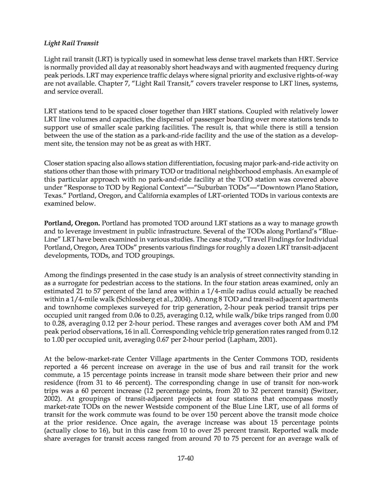
Two findings were highlighted by the researchers. First, the automobile remains a dominant com- muter mode among station-area residents. Second, transit mode shares are higher for station-area commuters than the overall 1990 Census data averages that were used for comparison. Table 17-10 shows some of the comparisons made between survey results for station area residents and the combined weighted average of 1990 Census data for the San Francisco-Oakland-San Jose Combined Statistical Area (CSA), Sacramento Metropolitan Statistical Area (MSA), and San Diego MSA. By way of background, it should be noted that station area residents reported smaller house- holds than the broader-area Census (1.89 versus 2.71 people per household) along with fewer vehicles (1.53 versus per household) (Cervero, 1993). 17-24 Project Location Broader Area 1990 Census Data Comparison System Mode Station Area Survey Mode Share Comparative Mode Share Comparison Area Used Mode(s) Included BART HRT 32.1% 5.0% BART Service Area a Urban rail Caltrain CRR 36.6% 1.7% San Mateo County Commuter rail Sacramento LRT 18.2% 2.4% Sacramento MSA All transit San Diego LRT 14.2% 3.3% San Diego MSA All transit SCCTA LRT 7.0% 3.0% Santa Clara County All transit b Notes: a Average over Alameda, Contra Costa, and San Francisco Counties b SCCTA survey mode share is for LRT, but all transit modes are used for Census comparison because LRT began operating in 1991, after the 1990 Census. Source: Cervero (1993). Table 17-10 Surveyed Station Area Transit Commute Mode Share Versus 1990 Census A binomial-logit rail transit choice model was estimated using the survey data for station area residents. The model gives the probability that a station-area resident would choose transit for a commute trip given the values of the included attributes. It does not speak to the question of why station-area residents make different use of transit than non-station-area residents. Although specific to the San Francisco Bay Area, the results have general interest. The model indicates that, given residence location within 1/2 mile of a station, workplace parking policy and workplace location are then the top two predictors of mode choice. Other important factors are the number of vehicles available for use by household members, employer provision of transit subsidies, and availability of a company car at the worksite (Cervero, 1993). Figure 17-1 illustrates rail transit choice probabilities obtained using a selection of sample attribute values. The 1992 California transit-focused development study also compared the station-area work-trip rail transit mode share obtained from a household survey conducted by the metropolitan planning organization (MPO) to the rail transit mode share reported in the 1990 Census for broader areas. The focus on rail transit use, to the exclusion of bus transit use, may overemphasize the difference in overall transit use for some locations. Table 17-11 highlights the degree to which station-area residents reported use of rail transit in higher proportions than citywide residents (Cervero, 1993).
The 2003 California TOD travel characteristics study obtained survey responses from 624 households in 26 station-area residential projects (representing a 13 percent response rate) and compared the results to data from the 2000 Census, selected to represent areas beyond walking distance of the station. The chosen projects were all âintentionally developed as TODsâ and located within 1/2 mile (deemed to represent walking distance) of a non-CBD transit station with a rail service headway of 15 minutes or less (Lund, Cervero, and Willson, 2004a).5 This method of selection does not address the degree or nature of land use mix in the station area overall. It only means that the selected âprojectsâ (apartments or other housing) were residential, similar in this respect to the 1992 California study, and were presumably planned with some version of TOD objectives in mind. 17-25 Figure 17-1 Sensitivity to parking, destination, and vehicles available of commute trip rail mode choice by San Francisco Bay Area station-area residents 5 Service frequency is the number of buses or trains per hour or day, while the headway is the time interval between buses or trains. Passengers arriving randomly will, if the transit service is reliable, have a waiting time which averages one-half the headway. Note: Reflects the setting of all other predictor values to zero, i.e., employer provides no transit expense assistance, employer provides no company car. Residence location within 1/2 mile of a rail station is a given. Source: Based on Handbook author calculations using model as specified by Cervero (1993).
A geographic information system (GIS) was then used by the 2003 study to identify and extract the Census data for a âdonutâ around each station representing the area between 0.5 and 3.0 miles of the surveyed projectâs rail station. Table 17-12 displays the composite findings. Overall, the reported residential project work-trip transit mode share averaged 27 percent versus 7 percent for residents within the respective âdonutâ areas. Looked at another way, public transit use for the commute trip for TOD project residentsâexpressed as mode sharesâaveraged four times the tran- sit share in surrounding areas beyond easy walking distance. The study also compared against commute mode shares in the surrounding city, finding surveyed project resident transit shares to be five times those for the city as a whole (Lund, Cervero, and Willson, 2004a). 17-26 Table 17-11 San Francisco Bay Area Comparisons of Station-Area and Citywide Work-Trip Rail Transit Shares Work-Trip Rail Transit Mode Share System (Mode) and Location Station-Area Residents a Citywide b BART (HRT) Pleasant Hill Fremont Union City Hayward San Leandro Oakland 46.7% 12.9% 27.5% 25.7% 27.7% 10.0% 16.0% 2.7% 3.8% 4.4% 6.1% 6.1% Caltrain (CRR) San Mateo 26.2% 2.8% SCCTA (LRT) c San Jose 7.0% 3.6% Notes: a Based on 1993 Metropolitan Transportation Commission survey results from 1992-93 allocated according to city jurisdiction. b 1990 journey-to-work Census statistics. These data have not been adjusted to account for any housing-type or demographic differences between station areas and non-station areas, and exclude workers who work at home. c San Jose statistics in each column are presented for rail and bus transit modes combined. (All modes are used because LRT service began in 1991, after the 1990 Census.) Source: Cervero (1993).
The 2003 California TOD travel characteristics study also determined project mode of access shares. Over 90 percent of the station area residents surveyed reached their neighborhood rail sta- tion by walking (Lund, Cervero, and Willson, 2004a). Although this particular study did not sur- vey mode of access shares from outside of the TOD projects for comparison, it is known from other surveys that walk access shares decrease markedly and motorized travel access shares increase steadily with distance of a residence from its station. For Chicago CRR examples see Tables 17-26 and 17-27 within the âUnderlying Traveler Response FactorsâââLand Use and Site Designââ âTOD-Supportive DesignâââWalking Distance and Transit Access/Egress Modesâ subsection. For HRT see Figure 3-3, âMode of access for commute trips from home to all BART stations,â found in Chapter 3, âPark-and-Ride/Pool,â under âRelated Information and ImpactsâââUsage Characteristics of Park-and-Ride/Pool FacilitiesâââMode of AccessâââBay Area Rapid Transit (BART).â Additional mode of access details from the 2003 California TOD travel characteristics study are presented in the upcoming âResponse to TOD by Primary Transit Modeâ subsection. Mention should be made, in connection with heavily residential TOD examples, of developments built as TODs that may meet their non-transit development objectives well but have not produced substantial transit ridership. The apartments in Long Beach, California, that are included in Table 17-12, are an example. None of the commute trips reported by 60 survey respondents used the LRT line on which the apartments were situated and the overall public transit mode share, at 3 percent, was barely over a quarter that of the surrounding area. The low transit share was made up for in travel demand management terms, however, by high rates of walking. The transit share explana- tion may likely be found in the reasons given by residents for why they chose the location. Their primary selection criteria, in this somewhat economically depressed area, were housing afford- ability and quality rather than location near transit (Lund, Cervero, and Willson, 2004a). 17-27 Project Setting Buildings Surveyed Mode Region Sample Size Project Mode Share 1/2 to 3 Mile âDonutsâ around Rail Station a Percentage Point Difference Pleasant Hill 4 HRT S.F. b 176 45% 13% +32% S. Alameda County 4 HRT S.F. 177 38% 2% +36% Long Beach 2 LRT L.A. 60 3% 11% -8% Mission Valley 2 LRT S.D. 185 13% 6% +7% Caltrain Commuter Rail 3 CRR S.F. 121 17% 5% +12% Total, with Weighted Average Percentages: c 719 27% 7% +20% d Notes: a Mode share for dwelling units within donut of rail stations from 2000 Census. b Region Key: S.F.âSan Francisco, L.A.âLos Angeles, S.D.âSan Diego. c Weighted average is based on project size; the weighting is applied to both project shares and shares for dwelling units within the station donuts. d Recomputed by Handbook authors. Sources: Lund, Cervero, and Willson (2004a). Table 17-12 Residential Project Versus Surrounding Area Transit Commute Mode Shares
Early and less complete evidence suggests another example might be the Whisman Station TOD in Mountain View, California, located within the high-cost-housing market of Silicon Valley. Average station-area income was almost $112,000 in 2000. With the TOD core one-half to two-thirds developed, and excellent pedestrian connectivity within 1/4 mile of the station, daily LRT boardings at Whisman were only 90 in 2000 and 94 in 2002. The 2000 U.S. Census turned up no commute trip transit use (Schlossberg et al., 2004). The 500-unit residential community is one of four TODs in Mountain View created with the dual objectives of creating densities supportive of enhanced transit service utilization and easing the cityâs imbalance of more jobs than housing. The small-lot and row houses sold quickly (Thompson, 2002). Whisman Station lies within walk- ing distance or a short drive of the high-tech Mountain View Triangle employment area. It appears the residential TOD may have met a local non-transit-oriented housing need that was stronger than the demand for homes well positioned for transit use. The two examples provided above appear to be extreme cases, but the 2003 California TOD travel characteristics study does offer this general conclusion: âIn most cases, [the surveyed California] households are moving to the TODs for the housing stock rather than the transit access; the exception to this is the BART [HRT] system, where residents are most likely to report âaccess to transitâ as their primary reason for moving. These priorities are also reflected in residentsâ reported travel patterns: transit use is much higher among residents living near BART stationsâ (Lund, Cervero, and Willson, 2004a). Some TOD residential developments, most notably examples focused on households for whom auto ownership may be difficult, have tipped the balance toward transit users by building provision of free transit passes for residents into the financial structure. See, for example, the Seattle area TODs described below under âResponse to TOD by Primary Transit Modeââ âTraditional BusâââKing County, Washington.â Provision of free transit for TOD residents is also further discussed under âParking Pricing and Transit Supportâ within the âRelated Information and Impactsâ section. Office Office development has strong peak-period travel demand as workers arrive and depart the facilities at similar times. It also generates midday travel demand as workers run errands, attend meetings, serve customers, and get lunch. Transit-oriented office centers enable building-to-building travel by walking, and easy connections to other activity centers via transit, offering the potential to capture a portion of trips that would otherwise be made by automobile. The 1992 California transit-focused development study surveyed more than 1,400 employees at 18 worksites within about 1/2 mile of rail transit and found that on average workers near rail stations were 2.7 times more likely to commute by rail than the average worker in the cities studied. The surveyed worksites were located in the San Francisco Bay Area (HRT and CRR), Santa Clara County (LRT), Sacramento (LRT), and San Diego (LRT). As with the transit-focused housing portion of the study, a binomial-logit model of modest predictive abilities was estimated to provide additional insight into the factors influencing rail transit choice by workers employed near rail stations. Fewer vehicles available at home, residence location in a BART-served city, workplace parking availability constraints, and pricing of parking appeared to be the most powerful positive influences on rail transit choice for this 17-28
population of workers. Having a workplace within 500 feet of a rail station, as compared to 500 to 3,410 feet from a station, was also a boost. (Surveyed worksites ranged from 50 to 3,410 feet from a rail station.) Other helpful factors included the availability of an employer transit subsidy, a longer commute distance, and few midday trips needed. Figure 17-2 illustrates the rail transit choice probabilities that are obtained with the model by using a selection of sample attribute values (Cervero, 1993). 17-29 Figure 17-2 Sensitivity to parking, origin, and vehicles available of commute trip rail mode choice by San Francisco Bay Area station-area workers Note : Non-named predictor variable values are held constant across scenarios (no employer transit allowance, commute distance is 14.7 miles, 0.9 parking spaces per employee, one midday trip for every two workers, workplace is less than 500 feet from rail station). Source: Based on handbook author calculations using model as specified by Cervero (1993). The 2003 California TOD travel characteristics study found higher total transit commute shares among station-area office workers (18.8 percent) as compared with the surrounding Census MSA workers (5.1 percent). This study received completed surveys from 877 workers at a total of ten worksites (see Tables 17-19, 17-20, and 17-21 for survey locations). Surveyed workers indicated an average door-to-door commute time of 69 minutes. This was longer than the average commute length reported in surveys of station-area residents (55 minutes), suggesting that station-area offices draw from a large commuter shed (Lund, Cervero, and Willson, 2004a).
WMATAâs â2005 Development-Related Ridership Survey,â in addition to obtaining worker com- mute information at 17 sites, also obtained midday trip information. Interviews of visitors were allowed at 13 of the sites. Site locations relative to HRT service ranged from directly at a Washington Metrorail station exit to 3,000 feet away, just over 1/2 mile. Both TODs and conven- tional development were included. Regional location ranged from the Washington CBD to outside the Capital Beltway. Table 17-13 displays the mode choice results. 17-30 6 While there are factors that make an increase in station area office worker transit shares logical, such as the preponderance of residential-oriented rather than office-oriented station areas among new stations added, the observation that shares doubled over time should be interpreted cautiously. As previously noted, the shares obtained are averages of surveyed sites, not area averages. Differences in which sites were surveyed between 1987 and 2005 may contribute significantly to the change in average office worker mode share noted. The 34 percent overall site average transit mode share for worker commute trips surveyed in 2005 was nearly double the transit share obtained in comparable 1989 office surveys.6 In contrast, the overall 2005 site average of 45 percent transit for all trips by residents at residential sites was little changed from 1989 (WMATA, 2006a). Retail Table 17-14 lists travel mode shares based on intercept surveys of patrons at five retail centers in Northern and Southern California. The 1992 California transit-focused development study looked at three large San Francisco Bay Area shopping centers sited within 0.25 miles of a BART Station: San Francisco Shopping Centre (SFCentre) in the city of San Francisco, El Cerrito Plaza in El Cerrito, and Bayfair Mall in Oakland. While SFCentre is located in the )tnecreP( erahS edoM Survey Population Trip Category or Purpose Metrorail Bus and CRR Auto Walk and Other Workers Commute trip 25% 9% 62% 6% Workers Midday trips 25 3 43 28 Visitors All office visits 16 7 [sic] 60 22 Work related 33% 3% 55% 9% Midday trips by workers Personal business 20 3 49 28 Meal or snacks 16 3 29 53 Shopping 21 5 54 20 Education 36 9 52 3 Recreation 26 0 44 30 51 36 2 12 rehtO Source: WMATA (2006a). Table 17-13 Office Site Mode Shares in the Vicinity of Washington Metrorail Stations for Various Trip Categories
heart of the downtown retail district, where parking is expensive, El Cerrito and Bayfair are more traditional enclosed shopping malls surrounded by free parking. SFCentre has a direct portal con- nection to BART. 17-31 Only 47 percent of SFCentre patrons arriving by BART had a vehicle available that they could have used for the trip, compared to more than 75 percent at the other two centers. The study did not report vehicle availability for bus transit riders. The proportion of patrons choosing rail tran- sit to access the station-area shopping centers increased with the length of the trip. For very short trips, less than 1 mile, walking was the predominant travel mode (Cervero, 1993; Cervero et al., 2004). The 2003 California TOD travel characteristics study looked at three shopping centers near rail transit stations in three cities: the Bay Areaâs El Cerrito Plaza (also surveyed in the earlier study), the Hollywood/Highland Complex in Los Angeles, and San Diegoâs Fashion Valley Complex. A total of 1,237 patrons were surveyed. Vehicle availability was again a factor in the use of rail transit to access retail: only 39 percent of respondents arriving by rail indicated that they had a vehicle available for the trip. This study, like the earlier one, did not report vehicle availability for bus transit users (Lund, Cervero, and Willson, 2004a). Across both California studies, the highest retail center transit shares were those for the centers in downtown San Francisco and downtown Hollywood: 34 percent (and 32 percent walk) for SFCentre and 32 percent (with 10 percent walk) for Hollywood & Highland. Both centers are served by direct connections to HRT plus intensive conventional bus service. The suburban retail center transit shares, excluding the older El Cerrito survey, range from 23 percent at BART HRT-served Bayfair to 13 percent at LRT-served Fashion Valley, averaging 17 percent (Cervero, 1993; Lund, Cervero, and Willson, 2004a). A 1986 survey in Ottawa, Canada, found a 61 percent transit share at the Rideau Centre in the Ottawa core. The Rideau Centre location is served by all Ottawa Transitway BRT routes. Other Ottawa area shopping centers, not on the busway in 1986, had transit shares of 9 to 22 per- cent. In the 1990s, with all these centers either on the Transitway system or served by Transitway routes, transit mode shares are reported to have reached at least 25 to 30 percent. Of particular interest is the suburban St. Laurent shopping center, located roughly two-thirds of the way out the East Transitway. The shopping mall is layered in between the busway station (below) and its feeder and connecting bus station (above) and in addition is connected Percent of Trip by: SFCentre Bayfair El Cerrito (1992) El Cerrito (2004) Hollywood Highland Fashion Valley Drive Car 17.5% 56.9% 64.0% 49.3% 50.9% 65.2% Ride Car 6.9 15.1 10.7 19.7 6.7 20.0 Rail Transit 20.8 18.8 6.6 11.7 16.6 7.2 Bus 13.0 4.4 4.0 2.2 15.4 5.6 Walk 31.8 3.5 12.2 14.8 10.3 1.6 Other 10.0 1.3 2.5 2.2 0.2 0.3 Sources: Cervero (1993) and Lund, Cervero, and Willson (2004a). Table 17-14 Mode Shares for Traveling to Station-Area Retail Centers
with other land uses. In 1986, before opening of the transitway, the transit mode share was 16 percent. With BRT in operation, the transit share has been reported as 32 percent (Parsons Brinckerhoff, 1996a) and â30 percent... for shoppersâ (Rathwell and Schijns, 2002).7 WMATAâs â2005 Development-Related Ridership Surveyâ conducted interviews at 5 retail, 5 hotel, and 4 entertainment sites at various distances up to or slightly over 1/2 mile from Washington Metrorail HRT stations. These sites are located both in TODs and in conventional development. All are outside the Washington CBD but inside the Capital Beltway. Table 17-15 displays the mode choice results. Overall average transit mode shares for the interviewed populations at these three uses were found to be fairly closely grouped at 37 percent (rail and bus) for retail, 32 percent for entertainment (movie theaters), and 31 percent for hotel (WMATA, 2006a). The average retail site transit share may be elevated relative to the entertainment and hotel sites because of including retail employees but is definitely boosted by personal business purpose trips. Retail site transit shares for individual trip purposes are provided in the lower half of Table 17-15. 17-32 Hotels About 12 percent of the TODs identified in TCRP Project H-27 included a hotel component (Cervero et al., 2004). Depending on the context, many hotel guests may not have use of a personal automobile during their stay. This potentially increases the pool of customers for )tnecreP( erahS edoM Site Land Use Survey Population or Trip Purpose Metrorail Bus and CRR Auto Walk and Other Retail Patrons and employees 29% 8% 36% 27% Entertainment Moviegoers 26 6 57 11 Hotel Guests and visitors 27 4 38 31 Retail Shopping trips 17% 8% 38% 37% Retail Dining trips 13 3 44 40 Retail Personal business trips 43 9 38 10 Retail Work and other trips 34 6 25 35 Source: WMATA (2006a). Table 17-15 Retail, Hotel, and Entertainment Site Mode Shares in the Vicinity of Washington Metrorail Stations 7 Some caution should be exercised in use of these Ottawa statistics, as the âafterâ transit mode shares are from different original sources and likely differing survey methodologies compared to the âbeforeâ shares. Note that the 1986 transit shares are almost certainly computed as a percentage of motorized trips, excluding non- motorized travel (walking, etc.) from the denominator, which âinflatesâ the transit shares relative to the California and WMATA share computations made on the basis of all trips (motorized and non-motorized). The âafterâ Ottawa shares are likely also computed using motorized travel only. The 1986 data apparently encompass all purposes of travel to the retail areas, not just shopping trips, while purposes covered by the âafterâ observations are mostly unspecified.
on-site retail and services as well as for transit services to other activity centers. Results of WMATAâs survey of Washington region station-area hotel patron transit shares are presented immediately above, in conjunction with Table 17-15. In addition, the 2003 California TOD travel characteristics study included a small-sample survey of hotel patrons and employees at two station-area hotels: the Embassy Suites at BARTâs Pleasant Hill Station and the Doubletree Hotel at the San Diego Trolleyâs Hazard Center Station. Data on 111 commute trips made by hotel workers were collected. At Pleasant Hill, 25 percent of the 84 hotel worker commute trips reported were by BART HRT. At the Hazard Center hotel, 25 of the 27 commute trips reported were accomplished using LRT. Overall, about 47 percent of total hotel worker commute trips reported used transit service (41 percent rail, 6 percent bus). The rest drove (51 percent), carpooled (1 percent), or walked (1 percent). The hotel patron survey was collected from 44 guests. Of the guests who responded, 14 percent arrived without a carâon the hotel shuttle, in a taxi, or by bus. No respondents using rail were captured, but the survey was taken before the BART extension to the San Francisco airport was open. Of the 24 percent of respondents who were arriving from the nearest airport, 70 percent came with a rental car. Over half of the surveyed guests (53 percent) reported using rail transit at some point during their stay and 30 percent reported rail transit as their âusualâ mode of travel. For business, 39 percent of guests used rail transit; for shopping/errands, 26 percent used it; and for entertainment, 30 percent used it. Of the 47 percent of respondents who reported no rail transit use, only 10 percent said that they were unaware of the service. The other 90 percent stated that they had no interest in using rail transit (45 percent), the service was inconvenient (30 percent), or they did not know enough about the service to use it (15 percent) (Lund, Cervero, and Willson, 2004a). Response to TOD by Primary Transit Mode This subsection explores the traveler response to TOD as differentiated by type of primary transit mode serving the project. Table 17-16 highlights the defining characteristics of each of the five major modes coveredâheavy rail (rail rapid) transit (HRT/Metro), light rail transit (LRT), commuter railroad (CRR), bus rapid transit (BRT), and traditional bus. The table also presents some perspectives on each major mode with respect to TOD. Most of what is considered TOD in the United States has been constructed at rail transit stations. The stakeholder survey conducted as part of TCRP Project H-27 identified 117 TODs. Of that total, 37 percent were located at HRT stations, 31 percent at LRT stations, and 22 percent at CRR stations, for a total of 90 percent at rail stations. Only 8 percent of total responses were for TODs located near bus facilities only. Just under 2 percent were at ferry terminal transportation centers offering over-water commuter connections to Seattleâs downtown (Cervero et al., 2004). Heavy Rail Transit Heavy Rail Transit (HRT/Metro) serves dense travel markets oriented primarily toward major city CBDs. Some of the largest TOD projects in the United States are associated with HRT stations. HRT typically operates all day at relatively high frequencies. Suburban HRT stations tend to have significant park-and-ride demand, creating a challenge in balancing the desire to develop station-area property and the desire to serve drive-access transit riders. 17-33
Selected examples are examined below and other examples appear in other parts of this âResponse by TOD Dimension and Strategyâ section. 17-34 Mode Typical Attributes Considerations Examples Heavy Rail Transit (HRT) Motorized cars draw power from a third rail and operate on exclusive right-of-way with no at-grade crossings. Off- board fare payment at or verified by fare gates. Large investment in HRT leads to very extensive station-area planning. High service levels and traffic-free operation attract substantial proportions of transit-using TOD residents. Special challenge with HRT suburban stations is finding balance with vast numbers of park-and-ride spaces. Atlanta, GA Chicago, IL San Francisco, CA Washington, DC Light Rail Transit (LRT) Motorized cars draw power from overhead wires and operate on some or all non- exclusive right-of-way with at- grade crossings. Off-board fare payment verified by random ticket inspection. LRT stations tend to be smaller scale and more closely spaced than HRT. Park-and-ride use can be a challenge. Substantial investment is required to build LRT, sparking similar levels of planning attention as HRT. Dallas, TX Denver, CO Portland, OR San Diego, CA Commuter Railroad (CRR) Railroad cars motorized or pushed/pulled by a locomotive. Often share tracks or corridor with freight trains. Ticket purchase verified by on-board conductor. Not all systems offer off-peak service or weekend service. Notable TOD projects are most associated with seven-day service and peak period headways of 20 minutes or so. Park-and-ride is an important CRR rider market. San Francisco, CA Chicago, IL New York - New Jersey Bus Rapid Transit (BRT) Premium bus service including: special vehicles, exclusive right-of-way segments, signal priority, upgraded waiting areas. Various fare payment methods employed including off-board. BRT systems involving special vehicles, dedicated lanes, and frequent seven-day service can logically have the same TOD possibilities as LRT. Park-and- ride can be a significant land use near berthing areas. Boston, MA Pittsburgh, PA Ottawa, Canada Traditional Bus Scheduled, fixed-route local and express bus services. Predominantly on-street running; may operate on special facilities. On-board fare payment. High-frequency traditional bus services (at least four vehicles per hour) can offer the potential to support TOD. Also, bus lines play a supportive role at most rail TODs. Boulder, CO Renton, WA Table 17-16 Perspectives on TOD as Differentiated by Primary Transit Mode
Arlington, Virginia. Arlington, Virginia, has two Metrorail HRT corridors, one extending to the west of Washington, DC, and the other to the south. The case study, âArlington County, Virginia, Transit Oriented Development Densities,â looks further at the western corridor. TCRP Project H-27 assembled and analyzed a time series database of development and ridership for the period from 1985 through 2002 for seven of the Arlington stations, Rosslyn through Ballston along the western corridor and the Pentagon City and Crystal City Stations of the south corridor. None of these inner-suburban stations has park-and-ride parking. As development increased in the corridors, so too did rail station usage. The researchers estimated three models. The opportunity to use time-series data limited the number of explanatory variables that could be examined. The first two models were simple bivariate regressions of development level versus station boardings and alightings. The third is a two-stage least squares estimation that incorporates a transit service measure, HRT passenger capacity per day (Cervero et al., 2004). The simple regressions exhibit good correlation but do not in themselves demonstrate causality. The fact that the two-stage ridership model, incorporating transit service and other measures, ascribes about half as much effect to station area developmentâcompared to the simple regressionsâsuggests that leaving out pertinent non-development factors leads to overstating the role of development. The effect ascribed to development in the enhanced two-stage model is, however, still quite substantial. This enhanced model indicates that each 1,000 additional spaces of passenger capacity passing through a station each day is associated on average with 210 additional passengers.8 For each 1,000 additional dwelling units along with 1,000 additional spaces of passenger capacity over 500 new boardings or alightings are estimated. Also, each 1,000 square feet of office and commercial space is estimated to engender nearly 500 new boardings or alightings (Cervero et al., 2004). Note that the additional ridership associated with added rail service and the additional ridership estimated in connection with new housing are not additive, as service effects are included in the housing-related estimate. Bus ridership time series data have not been assembled, but it is worthy of note that significant bus use is also observed in the Rosslyn-Ballston corridor. In 2002, average weekday bus passengers at the transit hubs at Ballston and Rosslyn totaled 16,300 and 4,370, respectively (Leach, 2004).9 These volumes compare to 2002 average weekday Metrorail passengers at these same stations of 22,430 and 29,630, respectively, as calculated at twice boardings (WMATA, 2002). Walking is the predominant method of access and egress at both of these stations: 67 percent at Ballston and 70 percent at Rosslyn (Harrington, 2006). There are high volumes of pedestrians crossing streets several blocks away from the Metro station entrances. 17-35 8 Passenger capacity was calculated at 4 passengers per square meter of available railcar space (Cervero et al., 2004). It is reasonable to assume that a significant portion of the passenger capacity increase was reflected in improved service frequency and its associated attractiveness, and that growing passenger volumes in the peak direction (primarily in-commuting from residences served by the Metrorail line) were a major impetus for the service increases. Although the researchers do not so state, there is thus a certain logic to the decision to asso- ciate capacity increase effects with numbers of dwelling units (rather than office/commercial space) in the enhanced model. The estimates produced by the enhanced two-stage model are in terms of average daily boardings and exits, i.e., Metrorail passenger trips either entering or exiting the system at an Arlington TOD station. 9 The Handbook authors presume that these bus passenger volumes are boardings plus alightings and that persons transferring between bus and Metrorail are counted as both bus and as rail passengers.
Most significant is that the transit service and mix of uses have supported the development growth with only a relatively modest increase in traffic volumes on the local and arterial streets in the corridor. Only Interstate 66 (which passes near the corridor) has experienced large traffic growthâit primarily functions as a regional facility rather than as a local substitute for Wilson Boulevard, the avenue beneath which the Metrorail runs (Burwell and Dittmar, 2002). California HRT. The 2003 California TOD travel characteristics study surveyed residents and workers at a total of 36 residential and office projects in selected rail station areas on HRT, LRT, and CRR lines. The researchers did not report aggregated responses in a manner that provides averages or totals by individual public transit mode. Instead, the survey results were aggregated by rail line segment for those segments with surveyed projects from which adequate responses were received (Lund, Cervero, and Willson, 2004a). Table 17-17 presents a summary of station-area resident responses for projects on the five such rail line segments. Two of the segments are served by HRT. The table also presents an all-data summary including projects not encompassed by the reported rail segments. Table 17-18 presents a summary of station-area worker responses for office projects on a different set of rail line segments, six in all and three of them HRT, as well as an all-data summary. Table 17-19 gives an overview of the 13 HRT station-area residential and office projects surveyed on the line segments that were reported on individually. Similarly, overviews of the seven LRT and four CRR projects on line segments reported on are given in Tables 17-20 and 17-21, respectively. HRT station-area residents had substantially higher transit commute mode shares than those of residents in LRT or CRR station areas. Higher transit shares relative to LRT or CRR were also found in most instances of HRT station-area resident non-work mode shares and station area workplace commute mode shares. However, the findings are not only a reflection of the transit mode involved but also of the selection of survey locations. Relevant survey location attributes influencing the results include the travel market context of each location and rail line segment; the specific transit service attributes such as hours provided, frequency, and accessibility; and the individual respon- dents who chose to answer the survey, including their socio-economic characteristics. Although very suggestive, the findings should not be taken as solely reflecting inherent differences among travel modes. Moreover, the inherent differences that are reflected pertain only to the particular manifestations of HRT, LRT, and CRRâincluding contrasts among these rail modesâthat are found in the California context. As illustrated previously in Table 17-12, the Pleasant Hill and South Alameda County HRT station-area projects achieve resident commute trip transit mode shares 32 and 36 percentage points higher, respectively, than immediately surrounding areas. Among HRT-using resident commuters, 96 percent in Pleasant Hill and all of the survey respondents in the South Alameda County sites reported walking as their mode of access to their station. The 2003 California surveys did allow estimation of the aggregate mode shifts which occurred when households moved into TODs along BART HRT from their prior residence, but only for the subset of survey respondents who changed workplace location when making their move. Within this subset, some 18 percent of respondents reported shifting from driving alone or carpooling to HRT, while about 14 percent reported shifting from rail or bus transit to driving alone or carpooling. This produced a net estimated shift of 4 percent of respondents to transit, equivalent to a 4 percentage points increase in the transit mode share. HRT in Los Angeles was not separately examined because of limited data, but was analyzed within a larger group of California rail systems associated with less than a percentage point 17-36
increase in transit mode share for households moving into TODs and changing workplace (Lund, Cervero, and Willson, 2004a). Further information is provided in the âOverall Mode Shifts from Before to After TOD Residencyâ subsection under âRelated Information and ImpactsâââPre- and Post-TOD Travel Modes.â 17-37 HRT LRT CRR All Attribute Pleasant Hill Alameda County a Long Beach Mission Valley Caltrain Grand Total b Commute Mode Share Single-occupant vehicle 49% 57% 88% 81% 77% 66% 5 5 4 5 5 4 loopraC Rail transit 44 37 0 11 16 24 Bus transit 1 1 3 2 2 2 Other (includes walk/bike) 2 1 3 2 1 2 Number of responses 176 177 60 185 121 877 Non-Work Mode Share Single-occupant vehicle 71% 53% 63% 68% 72% 61% 62 91 52 32 72 11 loopraC Rail transit 9 8 0 3 5 5 Bus transit 6 6 0 2 0 3 Other (includes walk/bike) 4 6 13 2 4 5 Number of responses 86 64 60 135 75 486 Employer Programs c Allows flexible hours 61% 51% 35% 53% 61% 54% Lets me work at home 20 18 7 16 24 17 Provides a car for day use 5 1 3 8 2 4 Helps pay for transit 20 17 14 13 20 16 Free parking at work 52 55 97 69 75 65 Helps pay for car commute 11 6 11 12 2 8 Number of responses 66 82 29 77 51 361 Statistics Projects surveyed 4 4 2 2 3 26 Stations surveyed 1 4 2 2 3 23 Overall survey response rate 13% 15% 16% 19% 10% 13% Notes: a âAlameda Countyâ includes Fremont, Hayward, South Hayward, and Union City projects. Source: Lund, Cervero, and Willson (2004a). b Includes responses from residents living in station areas at locations on rail lines with insufficient responses to list separately. c Station-area residents were asked which programs were provided by their employer. More than one response was permitted. Table 17-17 Summary of California Station-Area Resident Responses
17-38 HRT LRT CRR All Attribute Berkeley Walnut Creek / Fremont Holly- wood Mission Valley Sacra- mento Anaheim Grand Total a Commute Mode Share Single occupant vehicle 45% 79% 84% 85% 52% 85% 68% 01 8 51 21 4 3 5 loopraC Rail transit 25 14 8 2 15 5 12 Bus transit 14 4 0 1 14 2 7 Other (includes walk/bike) 12 1 4 1 4 2 3 Number of responses 104 110 51 210 286 67 853 Midday Trip Mode Share Automobile 8% 47% 50% 49% 31% 97% 40% Rail transit 2 3 0 0 3 0 2 Bus transit 0 0 0 1 2 0 1 Other (includes walk/bike) b 89 50 50 49 63 3 58 Number of responses 83 60 34 140 218 37 580 Employer Programs c Allows flexible hours 81% 56% 22% 76% 69% 47% 67% Lets me work at home 32 20 0 19 18 15 19 Provides a car for day use 8 0 0 20 10 0 10 Helps pay for transit 39 9 19 17 61 8 33 Free parking at work 33 77 89 83 25 87 57 Helps pay for car commute 2 7 5 10 4 10 6 Number of responses 93 98 37 199 272 60 780 scitsitatS Projects surveyed 1 2 2 1 2 1 10 Stations surveyed 1 2 2 1 2 1 10 Overall survey response rate 24% 21% 6% 26% 32% 11% 20% Notes: a Includes responses from workers at station-area locations on rail lines with insufficient responses to list separately. b Midday âotherâ trips were all between 97 and 100 percent walk and less than 3 percent bike or miscellaneous travel modes. c Station-area workers were asked which programs were provided by their employer. More than one response was permitted. Source: Lund, Cervero, and Willson (2004a). Table 17-18 Summary of California Station-Area Worker Responses
17-39 Parking Supplies Surrounding Density HRT Station Project Site Project Size a Dist. to Station (feet) b Walking Route Quality c On Site (Ratio) d At Station (Spaces) Pop. per Acre e Jobs per Acre e S.F. BART (10-15 min. headway) Berkeley Great Western Building f 400 emp. 137 A 1.6 0 23.65 20.64 Fremont Mission Wells 225 DU 2,367 C 1.3 940 9.68 5.32 Fremont Office Center f 300 emp. 915 A 2.1 2,026 13.57 8.04 Hayward Atherton Place Condos 83 DU 534 B 2.0 1,439 14.08 7.49 Pleasant Hill Coggins Square 87 DU 1,014 C 1.0 2,557 9.13 5.19 Iron Horse Lofts 54 DU 1,441 C 1.9 2,557 9.16 5.15 Park Regency 892 DU 1,319 B 1.0 2,557 9.26 5.07 Wayside Plaza 59 DU 1,640 B n/a 2,557 9.14 5.17 South Hayward Archstone Barrington Hill 188 DU 592 B 1.1 1,220 10.91 2.61 Union City Verandas Apartments 282 DU 930 B 1.0 1,196 10.24 3.53 Walnut Creek California Plaza f 1,200 emp. 1,318 C 0.7 1,989 8.13 10.73 L.A. Metro (10 min. headway) Hollywood/Highland TV Guide Hollywood Ctr. f 350 emp. 710 B 1.7 0 24.05 15.69 Hollywood/Western 5161 Lankershim f 600 DU 1,730 C 1.1 0 20.63 6.03 Notes: a Project size measures: for residentialâdwelling units (DU), for officeâemployees (emp.). b Most direct walking path from building entrance (or center of development) to nearest ticket machine at nearest station. c Walking path evaluated for pedestrian safety, utility, and comfort/aesthetics as follows: A = Excellent, B = Good, C = Fair. d Parking ratio measures: for residentialâspaces per unit, for officeâspaces per employee. e Surrounding densities for the 1 mile radius from the site (not the rail station); two sites within the same station area may thus have different âsurrounding densityâ figures. f Indicates station-area office site. All others are station-area residential sites. Source: Lund, Cervero, and Willson (2004a and 2004b). Table 17-19 HRT Sites Surveyed in the 2003 California TOD Travel Characteristics Study
Light Rail Transit Light rail transit (LRT) is typically used in somewhat less dense travel markets than HRT. Service is normally provided all day at reasonably short headways and with augmented frequency during peak periods. LRT may experience traffic delays where signal priority and exclusive rights-of-way are not available. Chapter 7, âLight Rail Transit,â covers traveler response to LRT lines, systems, and service overall. LRT stations tend to be spaced closer together than HRT stations. Coupled with relatively lower LRT line volumes and capacities, the dispersal of passenger boarding over more stations tends to support use of smaller scale parking facilities. The result is, that while there is still a tension between the use of the station as a park-and-ride facility and the use of the station as a develop- ment site, the tension may not be as great as with HRT. Closer station spacing also allows station differentiation, focusing major park-and-ride activity on stations other than those with primary TOD or traditional neighborhood emphasis. An example of this particular approach with no park-and-ride facility at the TOD station was covered above under âResponse to TOD by Regional ContextâââSuburban TODsâââDowntown Plano Station, Texas.â Portland, Oregon, and California examples of LRT-oriented TODs in various contexts are examined below. Portland, Oregon. Portland has promoted TOD around LRT stations as a way to manage growth and to leverage investment in public infrastructure. Several of the TODs along Portlandâs âBlue- Lineâ LRT have been examined in various studies. The case study, âTravel Findings for Individual Portland, Oregon, Area TODsâ presents various findings for roughly a dozen LRT transit-adjacent developments, TODs, and TOD groupings. Among the findings presented in the case study is an analysis of street connectivity standing in as a surrogate for pedestrian access to the stations. In the four station areas examined, only an estimated 21 to 57 percent of the land area within a 1/4-mile radius could actually be reached within a 1/4-mile walk (Schlossberg et al., 2004). Among 8 TOD and transit-adjacent apartments and townhome complexes surveyed for trip generation, 2-hour peak period transit trips per occupied unit ranged from 0.06 to 0.25, averaging 0.12, while walk/bike trips ranged from 0.00 to 0.28, averaging 0.12 per 2-hour period. These ranges and averages cover both AM and PM peak period observations, 16 in all. Corresponding vehicle trip generation rates ranged from 0.12 to 1.00 per occupied unit, averaging 0.67 per 2-hour period (Lapham, 2001). At the below-market-rate Center Village apartments in the Center Commons TOD, residents reported a 46 percent increase on average in the use of bus and rail transit for the work commute, a 15 percentage points increase in transit mode share between their prior and new residence (from 31 to 46 percent). The corresponding change in use of transit for non-work trips was a 60 percent increase (12 percentage points, from 20 to 32 percent transit) (Switzer, 2002). At groupings of transit-adjacent projects at four stations that encompass mostly market-rate TODs on the newer Westside component of the Blue Line LRT, use of all forms of transit for the work commute was found to be over 150 percent above the transit mode choice at the prior residence. Once again, the average increase was about 15 percentage points (actually close to 16), but in this case from 10 to over 25 percent transit. Reported walk mode share averages for transit access ranged from around 70 to 75 percent for an average walk of 17-40
4 to 10 minutes up to 100 percent for a 2- to 3-minute average walk. Survey respondents were, on the whole, not a transit-dependent population (Dill, 2006a and b). California LRT. Travel mode shares and employer attributes found for projects near rail stations on certain individual California LRT line segments were reported above for station-area residents and workers in Tables 17-17 and 17-18, respectively. Table 17-20 gives an overview of the seven LRT station-area residential and office projects surveyed on the three line segments that researchers reported on individually. 17-41 Parking Supplies Surrounding Density LRT Station Project Site Project Size a Dist. to Station (feet) b Walking Route Quality c On Site (Ratio) d At Station (Spaces) Pop. per Acre e Jobs per Acre e Sacramento LRT (15 min. headway) 8th and K Street Dept of Conservation f 450 emp. 165 A 2.6 0 9.04 37.62 Watt/Manlove California Center f 700 emp. 1,042 B 1.6 n/a 8.22 3.50 L.A. Metro Blue Line (10 min. headway) Long Beach Transit Mall Pacific Court Apts 145 DU 620 B 1.2 0 23.89 19.10 Pacific at 5th Street Bellamar Apts 160 DU 605 A 1.3 0 23.45 18.90 San Diego Trolley (15 min. headway) Fenton Parkway Archstone Mission Valley 736 DU 80 A 1.9 0 4.10 5.51 Union Square Condos 121 DU 150 A 2.5 1,000 7.19 10.90 Hazard Center Mission Valley Heights f 800 emp. 2,440 C 1.1 1,000 8.18 7.99 Notes: a Project size measures: for residentialâdwelling units (DU), for officeâemployees (emp.). b Most direct walking path from building entrance (or center of development) to nearest ticket machine at nearest station. c Walking path evaluated for pedestrian safety, utility, and comfort/aesthetics as follows: A = Excellent, B = Good, C = Fair. d Parking ratio measures: for residentialâspaces per unit, for officeâspaces per employee. e Surrounding densities for the 1 mile radius from the site (not the rail station); two sites within the same station area may thus have different âsurrounding densityâ figures. f Indicates station-area office site. All others are station-area residential sites. Source: Lund, Cervero, and Willson (2004a and 2004b). Table 17-20 LRT Sites Surveyed in the 2003 California TOD Travel Characteristics Study
The LRT examples from the 2003 California TOD travel characteristics study appear to be strongly affected by individual site conditions. As shown in Table 17-17, resident transit commute shares encountered were 3 percent (Long Beach) and 13 percent (Mission Valley). Worker transit commute shares (Table 17-18) were 3 percent (Mission Valley) and 29 percent (Sacramento). The Long Beach and Mission Valley station-area projects were found to have resident commute trip transit mode shares, respectively, that are 8 percentage points below and 7 percentage points above those of immediately surrounding areas (Table 17-12) (Lund, Cervero, and Willson, 2004a). The Long Beach apartment housing involved may represent one of those instances mentioned earlier where the housing development has met a need but that need is not transit oriented. The station-area resident walk access mode share for the Mission Valley segment, the only LRT segment with enough observations to support a station mode-of-access computation, is the lowest observed in the California study at 84 percent walk. The remaining 16 percent is, however, divided between bicycle access and bus access, such that the reported station access modes are 100 percent non-auto. Residents of LRT station areas were found to have distinctly more modest transit commute mode shares and corresponding non-work shares than residents of HRT station areas. The relationship was less strong for LRT station-area workplace commute mode shares, but on average the LRT shares were still lower than for HRT. Limitations in these comparisons are discussed above under âHeavy Rail TransitâââCalifornia HRT.â Sample sizes from the 2003 California surveys did not allow the LRT mode to be separated out when estimating the aggregate mode shifts exhibited by households moving into rail-based TODs. Survey responses for LRT in Sacramento, Santa Clara County, Los Angeles, and San Diego were therefore combined with responses for CRR from the San Francisco Peninsula and responses for both CRR and HRT from the Los Angeles region. This combined group of California rail-based TODs was estimated to have been associated with less than a percentage point increase in transit mode share for households moving into TODs and also changing workplace (Lund, Cervero, and Willson, 2004a). The large difference between the mode shift results for Portland LRT-based TODs and the California rail-based TODs is discussed under âRelated Information and ImpactsâââPre- and Post-TOD Travel ModesâââOverall Mode Shifts from Before to After TOD Residency.â Commuter Railroad Commuter railroad (CRR) service connects suburban residents to center city employment, usually over longer distances than other rail transit modes. CRR services generally operate on historic railroad alignments. CRR is generally marked by relatively low service frequencies and in many cases has limited service hours. Nevertheless, in a few jurisdictions, notably the Chicago and New York/New Jersey metropolitan areas, CRR carries passenger volumes approaching HRT levels observed elsewhere (APTA, 2004). Typically commuter rail TOD is in the form of predominantly residential projects focused on bringing commuters to within walking distance of a station. Most suburban CRR stations feature park-and-ride facilities and a few offer peak-period connecting bus or van service. Chapter 8, âCommuter Rail,â provides general coverage. 17-42
Chicago, Illinois. A 2002 origin-destination Metra passenger survey and corresponding develop- ment information were used to arrive at rail transit trip generation rates for three projects near Metra CRR stations. The two more-TOD-like projects had similar rail trip generation rates, higher than the less-TOD-like Burnside project at Hickory Creek, as follows: ⢠The Railway Plaza development has 417 residential units adjacent to the Route 59 Station. This development has a grid street pattern that connects to, and is oriented toward, the station. Here, the analysis indicated that 219 survey day Metra riders live in the development for a trip generation rate of 53 riders per 100 households. ⢠A comparable CRR passenger trip generation rate of 55 riders per 100 households was esti- mated for the two five-story buildings (55 units) making up the Spring Avenue Station devel- opment about 700 feet from the Stone Avenue Station. This development is integrated into an existing grid street pattern. ⢠The Burnside Station development is located 1.5 blocks from the Hickory Creek station on the Rock Island Line. The 160 townhouses in this development, although near the train stop, are not oriented towards the station. Based on the survey, 62 Metra riders live there for a rail tran- sit trip generation rate of 39 riders per 100 households (Metra, 2004). Although these useful CRR trip generation findings are suggestive of an effect on ridership of dif- fering station area development design characteristics, there are other possible explanations for the differences in the estimated generation rates. These include the fact that the Route 59 and Stone Avenue Stations are on a different Metra line in a different sector of the Chicago region than the Hickory Creek Station. South Orange, New Jersey. The Gaslight Common apartments were built adjacent to New Jersey Transitâs Sloan Street station. The station itself was renovated in 1995 to include commuter-oriented retail shops and sit-down restaurants. The development pushed the envelope on acceptable suburban density with 200 apartments on approximately 5.25 acres. Reportedly, many residents are young professionals who work in Manhattan and moved to the complex because the station offers direct service to Midtown. An indication of the typical life-stage of the residents is the developerâs observation that there are only three households with school-age children. Some 65 percent of the residents commute to work using mass transit and vehicle ownership is a low 1.35 per unit (Cervero et al., 2004; Marchetta, 2003). California CRR. Travel mode shares and employer attributes for projects near rail stations on reported-on CRR segments were presented for station-area residents and workers in Tables 17-17 and 17-18, respectively, introduced in the âHeavy Rail Transitâ subsection. Table 17-21 gives an overview of the three CRR station-area residential projects and one office project surveyed on the two line segments reported on individually. Only one of those segments, along the San Francisco Peninsulaâs Caltrain line, is covered from the perspective of station-area residents and only one segment is covered from the perspective of station-area workers. As with the other station areas surveyed, Long Beach excepted, the commuter rail station-area residents had a higher transit (bus and rail) mode share for work trips (17 percent) than their counterparts in the surrounding area as derived from the 2000 Census (5 percent). These findings were tabulated in Table 17-12. Home-to-station mode of access was not reported on, but was apparently on the order of 90 percent walk. 17-43
Caltrain CRR station-area residents who took the train to work reported walking from their desti- nation station to access their workplace in lower proportion than their counterparts using HRT or LRT (71 percent for CRR versus about 80 percent for HRT/LRT). This lower walk share at the workplace end of the trip is likely an artifact of workplace station placement, most particularly the peripheral location of the San Francisco downtown terminal, leading many riders to transfer to local transit services in lieu of walking (Lund, Cervero, and Willson, 2004a). This finding is not likely associated with place-of-residence TOD design or placement in any significant way. It reflects a railroad terminal placement circumstance affecting many CRR systems, although typi- cally to a somewhat lesser degree. Bus Rapid Transit Bus rapid transit (BRT) has the potential to carry large passenger volumes through suitable corridors. Specialized vehicles and off-board fare collection can reduce dwell times. Further- apart stop spacing compared to traditional bus services and the granting of vehicle priority through special lanes, exclusive rights-of-way, and/or traffic signal priority can provide travel time advantages. Chapter 4, âBusways, BRT and Express Bus,â provides coverage of 17-44 Parking Supplies Surrounding Density CRR Station Project Site Project Size a Dist. To Station (feet) b Walking Route Quality c On Site (Ratio) d At Station (Spaces) Pop. per Acre e Jobs per Acre e S.F. Caltrain Broadway Northpark Apts 510 DU 1,194 C 0.96 100 7.02 9.52 San Antonio Crossings 359 DU 1,066 A n/a 199 14.70 9.69 Palo Alto Palo Alto Condos 101 DU 1,791 B 1.0 388 8.47 11.44 L.A. Metrolink Anaheim Stadium Towers f 600 emp. 2,700 B 1.6 400 2.91 16.75 Notes: a Project size measures: for residentialâdwelling units (DU), for officeâemployees (emp.). b Most direct walking path from building entrance (or center of development) to nearest ticket machine at nearest station. c Walking path evaluated for pedestrian safety, utility, and comfort/aesthetics as follows: A = Excellent, B = Good, C = Fair. d Parking ratio measures: for residentialâspaces per unit, for officeâspaces per employee. e Surrounding densities for the 1 mile radius from the site (not the rail station). f Indicates station-area office site. All others are station-area residential sites. Source: Lund, Cervero, and Willson (2004a and 2004b). Table 17-21 CRR Sites Surveyed in the 2003 California TOD Travel Characteristics Study
traveler response to this mode of public transportation and also includes information on busway and BRT development impacts not specific to TODs. Ottawa, Ontario, Canada. The 37-mile Transitway carries approximately 200,000 passengers daily, including about 10,000 people on 190 buses during the peak hour. Approximately 70 percent of downtown commuters use the Transitway. The system uses a network of on-street bus lanes (located in the central area), expressway lanes, and 16 miles of busways. Between 1988 and 1996, 3,211 residential units and 4.7 million square feet of commercial and institutional development were constructed around its stations (Levinson et al., 2003). A comparison of two mixed-use neighborhoods, one with a Transitway station and one without, showed that the neighborhood served by the Transitway had a higher transit mode share. The two neighborhoods, Tunneyâs Pasture and Confederation Heights, share similar bus service, land-use, and household income profiles. In addition to lacking a Transitway station, Confederation Heights is located slightly further from the Ottawa downtown, which may account for some of the differ- ence in transit share. A comparison was also made between transit mode share at two universities served by the Transitway and at one that is not. Similar to the results of the neighborhood compar- ison, the university campuses served by the Transitway had a higher transit mode share (Parsons Brinckerhoff Quade & Douglas, Inc., 1996a). These comparisons are set forth in Table 17-22. 17-45 noitanitseD a sA 6-9 AM As an Origin 3-6 PM Mixed-Use Neighborhoods Tunneyâs Pasture b 47% 49% %13 %92 sthgieH noitaredefnoC Universities University of Ottawa b 68% 50% Algonquin College (Woodroffe Campus) b 51% 44% %04 %83 ytisrevinU notelraC Notes: a The 1986 transit share of all motorized trips (i.e., walking and cycling are excluded from the denominator) for all trip purposes. b Location is directly served by a BRT station. Source: Parsons Brinckerhoff Quade & Douglas, Inc. (1996a). Table 17-22 Transit Mode Shares for Selected Ottawa-Carleton Locationsa U.S. Busways and BRT. Travel data for TODs located along U.S. busways and BRT has not been encountered. Basic service, ridership, and development parameters for two U.S. BRT facilities are summarized here to offer an indication that results for TOD focused on major BRT installations may potentially be equivalent to those for TOD along LRT. The Silver Line in Boston, Massachusetts, is a next-generation BRT line. The complete line is to have two underground sections and one street-level section. The street-level section, which operates on a dedicated lane, opened as Phase I in July 2002. Phase II, an underground segment, opened in December 2004. It connects the downtown South Station intermodal hub
to the South Boston Waterfront, otherwise known as the Seaport. Special buses capable of carrying about 100 passengers traverse the transitway. Approximately three minute headways apply during the peak hour. Once buses reach the Seaport, many use existing streets, highways, and tunnels to reach a variety of destinations. The 1.1 mile tunnel has stations at South Station, the new Federal Courthouse, and the World Trade Center. Plans exist for further large-scale, high-density redevelopment around each of these new stations (MBTA, 2004a; MBTA, 2004b; Levinson et al., 2003). Pittsburgh, Pennsylvania, has three exclusive right-of-way busways featuring all-stops and express service to downtown. The most heavily used is the Martin Luther King, Jr. (East) Busway. A 2.3 mile, four-station extension to the original 6.8-mile, six-station line opened in June 2003. The original facility carried some 28,000 weekday riders, including suburban routes that utilize the facility, or about 5,400 riders in 110 standard and articulated buses in the morning peak hour, peak direction. None of the original stations were constructed with on-line park-and-ride facilities, but the four new stations bring a total of 800 spaces adjacent to the East Busway. From 1983 to 1996, 42 developmentsânew construction or renovationsâare reported to have been implemented within a six minute walk (1,500 feet) of the original East Busway. These include retail, residential, and office projects, not all of them necessarily oriented towards the busway. East Busway ridership has remained steady while the overall region has experienced a population and bus system ridership decline (Chang et al., 2004; Levinson et al., 2003; Wohwill, 2004). Traditional Bus Traditional local bus service acts as an important link to TOD regardless of whether or not it is the primary transit mode serving the location. It nearly always plays at least a supportive role at rail-centered TODs. In cases of TODs where bus is the dominant transit mode, multiple services tend to converge on the same location. Otherwise, especially in suburban contexts, traditional bus service may not operate at frequencies sufficient to serve as a catalyst for TOD. Under most circumstances, frequencies of fewer than four buses per hour effectively eliminate traditional local bus service from consideration for all but dependent or particularly loyal riders, especially if schedules are unreliable. Coverage of traveler response to different levels of traditional bus service is provided in Chapter 9, âTransit Scheduling and Frequency,â and Chapter 10, âBus Routing and Coverage.â Boulder, Colorado. TOD has been implemented around traditional bus service in Boulder. One Boulder Plaza is such a project, situated on the two blocks between the downtown transit center and a thoroughfare featuring a high-ridership, high-frequency bus service. The project is a mix of new construction and renovation, including infill on a pre-existing surface parking lot. The approximate make up of the project is 310,000 square feet of commercial space (office, retail, and restaurant), 75 high-end residential units, and 360 underground parking spaces. Additional parking is also available nearby. All individuals employed in the project have access to free bus passes and enclosed bicycle storage (Cervero, et al., 2004; City of Boulder, 2001; One Boulder Plaza, 2005a; One Boulder Plaza, 2005b). While project-specific figures on travel impacts are not available, data from a survey of the pedestrian mall one block away highlights the importance of these amenities. On the mall 11 percent of city of Boulder resident survey respondents were found to have arrived by bus, 15 percent by bicycle, and 25 percent by walking. Among these same city of Boulder resident respondents, 17-46
about 38 percent reported having a bus pass and 82 percent of those who arrived by bus had used the pass (RRC Associates, 2004). King County, Washington. Two suburban King County, Washington bus-oriented TOD develop- ments were completed circa 2000, both located at transit centers. One, the Village at Overlake Station, is at the Overlake Transit Center in Redmond, located behind strip development. The other, Metropolitan Place, is part of a larger TOD complex at the Renton Transit Center. These developments are described in Table 17-23 (Shelton and Lo, 2003; Prince et al., 2003). Creation of viable TODs at these locations was greatly facilitated by King County Metro bus service restruc- turing and expansion with emphasis on shifting toward a âhub and spokeâ route system for sub- urban and outlying city of Seattle areas. Quantification of bus service changes and ridership outcomes immediately pre-TOD, particularly for the initial half of Metroâs âSix-Year Transit Development Plan 1996-2001,â is found in the Chapter 10 case study, âService Restructuring and New Services in Metropolitan Seattle.â The case study focuses especially on the service âhubâ located at the Renton Transit Center. 17-47 Village at Overlake Station Metropolitan Place AW ,notneR AW ,dnomdeR noitacoL Former use Surface park-and-ride lot Downtown auto sales lots New uses 536 space parking garage 308 rental housing units 2,400 sq ft child care facility 240 space parking garage 90 rental housing units 4,000 sq ft ground-level retail Affordable Housing Component All units are priced to be affordable to households earning 60 percent of areaâs median income and 30 units are wheelchair accessible. At least half the units are priced to be affordable to households earning 80 percent of the countyâs median income. Parking Integrated two-level parking structure. 150 spaces are reserved for park-and-ride during the day. Integrated two-level parking structure. 90 spaces are for resident use at all times. 150 spaces are leased by transit agency for park-and-ride; 30 of these are available for residents or visitors during non-commuter hours. Transit Adjacent to major bus transfer center. Buses operate at least 80 feet from units. Metal and glass awning on building to shield residents from noise and fumes. Bus transfer center is across the street. Incentives All residents receive a free bus pass. One free bus pass per unit. .edam osla stnemevorpmi nairtsedeP rehtO Source: Shelton and Lo (2003). Table 17-23 Two King County Bus Transit Oriented Developments Although full surveys of the Overlake and Renton apartment residents have not been published, some information is available. The Overlake Station development is a mixed-use,
below-market-rate housing project that replaces a former surface park-and-ride lot. One report is that one-third of Overlake residents regularly use the bus passes they received, with half of those pass users indicating that they have increased their transit use since moving into the building (Shelton and Lo, 2003). A survey with 40 returns suggested that roughly half the residents were riding the bus on a regular basis. Resident parking use in the project garage, which also serves park-and-ride, was observed to be 0.6 resident autos per dwelling unit (Prince et al., 2003, Posthuma, 2003). An overview assessment has concluded that Overlake Station, by combining âgood quality TOD, good quality transit service and affordable housing,â achieved success by focusing on meeting the needs of those who cannot afford cars (Hendricks, 2005). The Renton Transit Center and adjacent Metropolitan Place development are immediately adjacent to Rentonâs traditional downtown. The TOD and transit center partially continue the downtown street and sidewalk grid. In addition to the Metropolitan Place project, two other residential apartment buildings have been constructed adjacent to the Transit Center, with 165 dwelling units. Other new development in the vicinity includes office space, condominiums, and a large municipal parking garage with ground-floor retail. A little more than one-third of the Metropolitan Place residents are reported to use their bus pass regularly. The residents are anecdotally reported to be older and more predominantly empty-nesters than anticipated (Shelton and Lo, 2003; Prince et al., 2003). UNDERLYING TRAVELER RESPONSE FACTORS A number of different factors that affect TOD resident, worker, and visitor travel decisions, along with residence location choice decisions, are explored in this section. Of necessity, these factors are laid out one at a time for discussion. The various influences on travel behavior choices are, how- ever, decidedly interactive in nature. Moreover, these factors are not all transportation-related, suggesting that it takes more than good transportation policy alone to develop high-quality and effective TOD (Hendricks, 2006). The interactive nature of underlying traveler response factors affecting TOD also poses an exceptional challenge to fully understanding the importance and role of individual influences. Land Use and Site Design This discussion of land use and site design effects on TOD travel demand is organized to address TOD-specific aspects of the âthree Dâsâ of density, diversity, and design from a TOD-supportive perspective. Comprehensive coverage of the topic of traveler response to the âthree Dâsâ is pro- vided by Chapter 15, âLand Use and Site Design.â TOD-Supportive Density Higher development densities and correspondingly higher trip densities are associated with TOD. Increased development density places more housing, jobs, and activities within the same land area. The effective density of trip making in TOD may be further increased relative to non-TOD by the transit-supportive practice of clustering the highest density TOD components at or near the TODâs transit stops, rather than spread out evenly over the site. The concentration of trip ends resulting from TOD-supportive density creates a larger 17-48
potential market for transit. Even assuming no increase in transit mode share as a result of density in and of itself, higher-density development generates more transit ridership per unit of land areaâand thus per transit stop or stationâthan lower-density development.10 The added ridership potential of TOD-supportive densities can facilitate providing the cost- effective, higher-quality transit service desirably associated with TOD. Although high density may itself not directly cause significantly higher transit and walk mode shares, as explored in Chapter 15 under âResponse by Type of StrategyâââDensity,â important second order effects of high density can. These factors that boost transit ridership and walking include both the better transit service density allows and lower vehicle ownership rates. In part for similar reasons, and aided by the shorter travel distances involved, higher densities are also associated with greater use of non-motorized transit access and egress modesâhigher walk access mode shares in particular. As a result of all these associations and related experience, many jurisdictions have developed guidelines that call for increased TOD densities to achieve desired outcomes that specifically include increased use of transit (Tumlin and Millard-Ball, 2003; Cervero et al., 2004). (For more on TOD design to achieve objectives, see the âTransit Oriented Development Indexâ presentation that concludes the âRelated Information and Impactsâ section.) TOD-Supportive Diversity More-diverse TOD projects in terms of land use mix offer the possibility of a greater proportion of activities being conducted within the center and a corresponding reduction in motorized-travel trip generation, as alluded to in Table 17-8 under âResponse by TOD Dimension and Strategyââ âResponse to TOD by Land Use Mix.â As with non-TOD development, diverse land use can enable more needs to be satisfied on a single visit and allow internal walking trips to serve for visiting multiple destinations. TODs with both jobs and housing can serve to balance the utilization of transportation infrastructure, both highway and transit, and help create an all-day environment. While such TODs can and do capture some commute trips internally, it should be noted that resi- dence and workplace location decisions are not always contemporaneous or fully flexible (Cervero et al., 2004). To the extent that TOD leads occupants or visitors to arrive by transit in greater proportions than at non-TOD development, the availability of automobiles to occupants and visitors is reduced. The opportunity to meet needs within the TOD that land use mix affords makes this outcome more acceptable, likely enhancing both the transit mode share and the prevalence of pedestrian travel within the development. With implementation and study of more TOD examples should come increased understanding of traveler response to different mixes of land use including the travel behavior effects of potential synergies. In the meantime, research findings assembled in the âResponse by Type of StrategyâââDiversity (Land Use Mix)â subsection of Chapter 15, âLand Use and Site Design,â may be judged largely relevant to TODs if applied with due appreciation of den- sity and transit service level differences. 17-49 10 The relationship is not purely arithmetic. For example, with increased activity within a TOD may come a greater internalization of travel (as discussed with respect to âTOD-Supportive Diversityâ), and internal trips will not be candidates for using the regional transit service. For an estimate of transit use increase in response to TOD densification that is derived from actual experience, see the âArlington, Virginiaâ exam- ple under âResponse by TOD Dimension and StrategyâââResponse to TOD by Primary Transit Modeââ âHeavy Rail Transit.â
In one study of rail mode of access and egress for development near rail stations in the San Francisco Bay Area, a strong positive association was found between mixed station-area land use and higher propensity to walk for access and egress trips. The study observed that people are willing to walk farther to and from stations in denser, mixed-use settings than in areas with large parking lots and low-density residential development. Conversely, people tended to forgo walking to access stations surrounded by large surface parking lots and instead drive in (Cervero et al., 1995). TOD-Supportive Design In TOD, buildings are concentrated within close proximity to the transit stop and particular attention is paid to the pedestrian environment. The compact, pedestrian-friendly design of TOD leads to higher transit usage and walking because of the underlying traveler responses to this environment. In particular, the shorter walking distances encourage transit usage, the shorter walking distances encourage walking for transit access, and the pedestrian-friendly design encourages more walking overall. Each of these factors is explored further in the subtopics below. Also highly relevant is the pedestrian catchment area analysis reported in the case study, âTravel Findings for Individual Portland, Oregon, Area TODs,â under âResults.â It points out that actual walking distances to stations are greatly affected by street and pedestrian system layouts. Assessments of the street systems within four TODs estimated that only 21 to 57 percent of the area within a 1/4-mile radius of each station was actually within a 1/4-mile walk (Schlossberg et al., 2004). Related general topic coverage is provided in Chapter 15, âLand Use and Site Design,â and Chapter 16, âPedestrian and Bicycle Facilities.â Within Chapter 15, see especially âCommunity Design and Travel Behaviorâ and âTransit Supportive Design and Travel Behavior,â both within the âResponse by Type of StrategyâââSite Designâ subsection. Also of special interest is the Chapter 15 case study, âSan Francisco East Bay Pedestrian Versus Auto Oriented Neighborhoods,â discussed further below. Walking Distance and Transit Usage. Nearly all trips made by transit involve at least one if not two segments that require walking. Perhaps the single most important site design element when it comes to influencing transit usage is the walking distance from the transit station to the front door. Transit mode shares decline as distance from the transit station increases. This ridership gradient is seen at both the home and non-home end of trips. Moreover, walking distances at the home and non-home ends of trips work together to determine the likelihood of transit use. The existence of a mode share gradient vis-Ã -vis walking distance is observed not only for both res- idential development and office development, but also for both urban stations and suburban sta- tions. Whether for residential or office, the transit mode shares observed at any given distance from the station tend to be higher at urban stations than at suburban stations. Development integrated with transit stations such as through direct pedestrian connections may receive an added boost in transit mode shares (Cervero et al., 2004). Observed differences among mode share gradients are partially a reflection of differences in the specific developments that have been surveyed. Such differences include urban versus 17-50
suburban travel market differences, person-density differences, differing land use arrangements, and differences in parking charges and commute transportation policies among office employers. Table 17-24 presents a summary of available walk distance ridership gradient relationships from California and Washington, DC. 17-51 Study Residential-Focused Developments Office-Focused Developments 1992 California transit- focused development study (Cervero, 1993) Percent Rail = 32.24 - 0.0085*M R-Squared = 0.381 (Based on surveys at 27 projects) Percent Rail = 1105*(M)-0.795 R-Squared = 0.381 (Based on surveys at 18 projects) 2003 California TOD travel characteristics study (Lund, Cervero, and Willson, 2004a) No discernable relationship. (Based on surveys at 25 projects within 0.5 miles of transit) Percent Transit = 52.3 - 6.7*log(M) (Based on surveys at 10 projects within 0.5 miles of transit. See text for discussion.) 1989 Washington, DC, development-related ridership survey (JHK & Associates, 1989) Percent Transit = 66.52 - 0.0156*M R-Squared = 0.40 (Based on surveys at 18 buildings) CBD offices: Percent Transit = 61.37 - 0.0076*M R-Squared = 0.57 (Based on surveys at 7 buildings) Suburban offices: Pct. Trans. = 27.16 - 0.0061*M - 0.84*D R-Squared = 0.47 (Based on surveys at 40 sites) 2005 Washington, DC, development-related ridership survey (WMATA, 2006a) Percent Rail = 54.15 - 0.0087*M R-Squared = 0.41 Percent Transit = 54.83 - 0.0071*M R-Squared = 0.24 (Based on surveys of all trips at 18 sites) Percent Rail = 35.38 - 0.0096*M R-Squared = 0.25 Percent Transit = 46.15 - 0.0121*M R-Squared = 0.31 (Based on surveys of commute trips at 17 sites) Notes: M = distance from station to building in feet. D = distance from building to CBD in miles. Sources: As indicated in the âStudyâ column. Table 17-24 Summary of Walk Distance Ridership Gradient Relationships for Work Trips The ten office projects surveyed in the 2003 California TOD travel characteristics study provide a striking example of the interplay between mode share, distance, and other different characteristics of specific developments. Eight of the office developments surveyed were between 500 and 2,700 feet of a rail station. None of these exhibited a rail/bus transit mode share of over 6 percent of workers surveyed and there was no discernible relationship to distance among the corresponding eight data points. The shape of the nearly asymptotic relationship reported in Table 17-24 is largely formed by two statistical outliers, the state of California Department of Conservation building in downtown Sacramento, reporting a 27 percent transit mode share, and the Great Western Building in downtown Berkeley, in San Franciscoâs East Bay area, reporting a 17 percent share. Besides being just 165 feet from a light rail transit (LRT) stop in the case of the Department of Conservation and 137 feet from the nearest BART heavy rail transit (HRT) station entrance portal in the case of the Great
Western Building, these two buildings have the following similar contributing characteristics: high workers per acre densities of 37.6 and 20.6, respectively; dense, mixed-use surroundings; parking costs of over $100 per month; and no parking at the nearest rail stations (Lund, Cervero, and Willson, 2004a). Analysis of a large survey sample resulting from trip reduction monitoring requirements in effect during the mid-1990âs in the San Francisco Bay Area provides findings that are not as project dependent. From 1992 to 1995, more than 250,000 surveys were collected by the Bay Area Air Quality Management District from over 1,100 work sites in Napa, Marin, San Mateo, Santa Clara, Alameda, Sonoma, and Solano counties. Analysis of these survey findings clearly shows the drop- off in transit mode share as distance between the work site and its rail station increases, and also shows differences among rail transit modes. The differences among transit modes are muted once BART HRT stations in higher density employment areas with paid parking are excluded. The steepest transit share drop-off observed overall was that around Santa Clara County LRT stations.11 It appears that potential transit users are quite sensitive to walking distance, particularly around stations located on the north end of the Santa Clara County system, where development is low density and few shops or restaurants are nearby (Dill, 2003). Table 17-25 highlights these findings. 17-52 epyT noitatS yb erahS edoM etummoC tisnarT HRT LRT CRR Distance of Worksite from Station BART a BART Excluding Oakland and Berkeley Santa Clara County Caltrain All 0.00 to 0.25 miles 33.6% (44) 6.2% (3) 5.9% (49) 7.0% (14) 19.8% (107) 0.25 to 0.50 miles 7.9% (22) 5.7% (13) 3.1% (56) 4.1% (39) 4.0% (117) 0.50+ miles â â â â 2.5% (929) Notes: The numbers in parentheses are the number of worksites surveyed in the particular category. a San Francisco work sites, with their prevalence of paid parking and high densities, were not included in the survey or analysis. The additional exclusion (in the second of the two BART columns of data) of Oakland and Berkeley, also characterized by prevalence of paid parking and high densities, provides mode share by distance data for work sites where the prevalent condition is free parking and lower densities (Dill, 2006a). Source: Dill (2003). Table 17-25 Transit Mode Share by Distance of Work Site Location from Station Research in Toronto and Edmonton, Canada, has also illustrated the decline in transit mode share as distance of development from the nearest rail station increases. Figure 17-3 shows 11 It was noted that the earlier 1992 California transit-focused development study obtained similar results for BART HRT and Caltrain commuter rail (CRR), but somewhat higher transit mode shares among employ- ees near Santa Clara County LRT stations. It was speculated that those outcomes related to the specific sites selected for investigation (Dill, 2003). Findings from the 1992 effort (Cervero, 1993) were presented in the subsection, âResponse to TOD by Land Use Mix.â
this distance-related decline in transit mode share for residential development in the Canadian cities and for the earlier Washington, DC, region and California studies. Figure 17-4 shows the same for office development. While the Canadian and California studies looked at rail transit trips, the Washington study looked at all transit trips. It should also be noted that, because the studies rely on relatively few specific projects for data collection, the results are influenced by the specific characteristics of the projects selected. 17-53 Figure 17-3 Work trip rail mode share by distance from residential sites to station Notes: The graphed 1989 Washington, DC, area shares are for all transit (rail and bus combined). California and Canadian mode shares are for rail transit only. See last row of Table 17-24 for Washington, DC, 2005 mode share gradients for Metrorail only and rail and bus combined. Source: Cervero (1993). Results from station-area analyses carried out using the 2000 San Francisco Bay Area travel survey illustrate the interplay of walk distances at both ends of a trip. Mode shares were analyzed for per- sons living and/or working within, or not within, 1/2-mile walks of rail transit stations or stops and ferry terminals. Walking distances were measured along street-system approximations of the true pedestrian network. The regionwide average home-based work (commute) trip transit shares obtained for the four possible combinations of transit station proximity were: ⢠42 percent transit for commutes with both residence and workplace within 1/2 mile of a station/stop/terminal.
⢠28 percent transit for commutes with the workplace but not the residence within 1/2 mile. ⢠16 percent transit for commutes with the residence but not the workplace within 1/2 mile. ⢠4 percent transit for commutes with neither the residence nor workplace within 1/2 mile. 17-54 Notes: The graphed 1989 Washington, DC, area shares are for all transit (rail and bus combined). California and Canadian mode shares are for rail transit only. See last row of Table 17-24 for Washington, DC, 2005 mode share gradients for Metrorail only and rail and bus combined. Source: Cervero (1993). Figure 17-4 Work trip rail mode share by distance to office sites from station Even though there are other potential contributors to these mode share differentials besides walk- ing distance, such as income (which tends to be lower close-in to San Francisco Bay Area stations), the importance of home-work linkages via transit and location near stations is well illustrated by these summary data (Metropolitan Transportation Commission, 2006). Walking Distance and Transit Access/Egress Modes. The short walking distances from transit to development entrances that pertain in the ideal TOD contribute not only to elevated transit mode shares but also to high walk-access mode shares. The 2003 California TOD travel characteristics study reported that over 90 percent of surveyed residents of station-area housing who were rail commuters walked to access their rail station. The same study also surveyed station-area office workers, albeit at different sites. At the workplace end of the trip, 78 percent of station-area workers commuting by rail reported walking from the station to the workplace.
The design advantages of a TOD of course do not affect conditions at the opposite end of a trip from the TOD. The same surveyed rail commutersâfor whom transit access/egress share aver- ages within the TOD are given aboveâalso provided data for the egress/access modes at the other end of their trip. These were vastly different for home station access shares. Only 33 percent of 187 surveyed TOD area workers that commuted using rail reported walking to their origin rail station. Other modes they used to access the origin station were driving alone (51 percent), riding as an automobile passenger (6 percent), riding a bus (8 percent), and bicycling (2 percent). TOD resi- dents, on the other hand, reported about the same degree of walking from their non-home rail sta- tion to the workplace (79 percent) as did surveyed station-area office workers (Lund, Cervero, and Willson, 2004a). Another instructive study, this one in the Chicago region, focused on commuter railroad (CRR) travel by residents dwelling in the area around six high-ridership Metra stations. The case study stations were selected to represent a geographical distribution, a variety of community types, and differing service characteristics. A passenger survey was conducted at each of the stations with an overall response rate of 32 percent. Most CRR riders traveling less than 1/2 mile to access the rail station were found to be walkingâ82 percent on average. This walk access share was found to drop sharply with increasing access distance. The six-station average shares for each access mode and access-distance range are displayed in the upper half of Table 17-26. Distributions of station-access trips across each access-distance range are shown for each access mode in the lower half of the table. 17-55 The same study provides further information on the effect of station access distance on transit use, CRR ridership in this instance. Rail transit mode market penetration was found to fall sharply outside the 1/2-mile radius of each station. A number of characteristics were identified that appeared to contribute to the high ridership of the six stations, most notably a Drove Alone Carpool Dropped Off Bus Walked Other Mode of Access Shares by Access Trip Length (percentages calculated across each row) 0.0â0.5 mile 7.5% 0.4% 9.3% 0.0% 82.2% 0.7% 0.5â1.0 mile 33.4% 2.9% 16.4% 3.1% 41.3% 2.8% 1.0â2.0 miles 53.3% 3.2% 17.4% 14.2% 8.2% 3.8% More than 2.0 miles 63.7% 5.9% 11.4% 16.4% 1.0% 1.6% Overall Mode of Access 47.3% 3.8% 13.6% 11.0% 21.9% 2.2% Access Trip Length Proportions for Each Mode of Access (percentages calculated down each column) 0.0â0.5 mile 2.2% 1.3% 9.5% 0.0% 52.4% 4.3% 0.5â1.0 mile 13.4% 14.3% 22.9% 5.4% 35.8% 23.9% 1.0â2.0 miles 29.9% 22.1% 33.8% 34.2% 10.0% 43.5% More than 2.0 miles 54.5% 62.3% 33.8% 60.4% 1.8% 28.3% Note: Access trip length was self-reported by survey respondents. Source: S.B. Friedman & Company et al. (2000b). Table 17-26 Mode of Access Versus Distance Relationships for Six High-Ridership Metra CRR Stations Combined
good pedestrian environment with a concentration of development around the stations including stores (S.B. Friedman & Company et al., 2000a and 2000b). Table 17-27 presents the surveyed sta- tion characteristics and ridership statistics, with the final entries highlighting the drop in market penetration with increasing distance from the stations. 17-56 Attribute Home- wood 103rd Beverly Glen Ellyn Arlington Heights Naper- ville Deer- field Average Miles to Chicago CBD 23.5 12.8 22.4 22.8 28.5 24.2 22.4 Park-and-Ride Spaces 560 346 666 1,178 1,339 641 788 Utilization 97% 91% 83% 78% 95% 85% 88% Feeder Bus Routes 3 1 5 2 15 2 5 Weekday Trips a 1,578 969 1,889 2,579 4,040 1,279 2,056 Mode of Access Drive alone 46% 41% 34% 50% 47% 66% 47% Carpool 3% 6% 3% 4% 4% 3% 4% Dropped off 17% 10% 15% 14% 14% 8% 14% Bus 6% 6% 14% 3% 20% 1% 11% Walked 26% 36% 32% 26% 13% 19% 22% Other 2% 1% 2% 3% 3% 4% 2% Residential b Population 2,527 6,162 3,899 4,855 3,676 3,615 4,122 Households 1,146 1,857 1,690 2,480 1,528 1,538 1,707 Households/acre 6.4 15.6 9.9 12.3 9.3 9.2 10.4 Market Penetration (Percent of Households that use CRR) 0.0â0.5 mile 21% 15% 15% 15% 13% 10% 15% 0.5â1.0 mile 9% 2% 13% 7% 9% 7% 7% 1.0â2.0 miles 3% 1% 4% 4% 6% 4% 3% Note: a Passenger boardings plus alightings from Metraâs 1999 Metra Rail Service and Residential Development Study. b Within 1/2 mile of the station. Source: S.B. Friedman & Company et al. (2000a and 2000b). Table 17-27 Selected Attributes from Six High-Ridership Metra CRR Stations Pedestrian-Friendly Design and Walking and Transit Use. The quality of walk connections has been shown to influence the distance people are willing to walk. A short walk made difficult or unpleasant by adverse environmental conditions such as high-speed traffic or lack of shade can seem longer while a long but pleasant or interesting walk can seem shorter. It follows logically that quality of the pedestrian connections between the transit stop and the front door of the development should be important to transit usage. In many TOD exam- ples, special attention has been given to the pedestrian environment, including streetscape
improvements. It is generally held that the placement of parking lots, green spaces, and the build- ings themselves can impact the pedestrian and transit friendliness and attractiveness of travel by transit or walking (Arrington et al., 2002). Results from development of an advanced travel demand model set for San Francisco County lend support to the concept that the quality of walk connections to transit is positively related to tran- sit use. Neighborhood vitality at the destination was found to have a strong positive relationship to the choice of all non-auto modes examined (walk, bike, and transit) for most types of trips. Adverse topology (steep gradients and barriers) was nearly as important. Connectivity at the des- tination was also, for work trips, significantly and positively related to walk and transit choice (Cambridge Systematics et al., 2002). The lesser importance in the San Francisco travel models of connectivity, and the lack of significance of conditions at the trip origin, are likely artifacts of model calibration with travel data from a city with limited pedestrian-friendliness contrasts. Few city/county of San Francisco non-industrial areas have poor pedestrian connections and most neighborhoods are basically pedestrian-friendly. The calibration results for the San Francisco demand model are more extensively covered in Chapter 15 under âResponse by Type of StrategyâââSite DesignâââTransit Supportive Design and Travel BehaviorâââPedestrian/Transit-Friendliness.â The same subsection of Chapter 15, along with the âIndividual Urban Design Elementsâ subsection that precedes it, also presents other bits of evidence that a relationship between quality of walk connections and transit use indeed exists. The 2003 California TOD travel characteristics study performed several analyses of collected sur- vey data to explore the influence on transit usage of neighborhood design and streetscape attri- butes specific to station-area developments. The analyses and findings were: ⢠Simple correlations between design attributes and transit usage for specific trips yielded hints of positive relationships between more pedestrian friendly elements and greater transit usage, but also produced some counter-intuitive correlations. The results were most consistent with expectation for station-area office workers, showing modest positive relationships between higher transit shares and densities of retail shops, street connectivity, sidewalks on at least one side, street tree density, street light density, and frequency (shortness) of blocks, with a nega- tive transit use relationship for street width. ⢠A multiple regression model of project-level transit mode choice versus project attributes found greater street tree density, street furniture density, and crosswalk density to be positively related to greater transit share, all else being equal. This model is presented in Table 17-28. ⢠A disaggregate model of individual-level commute trip transit choice identified only one neighborhood design variable as having statistical significance, namely, street con- nectivity in the area around the work end of the commute trip. The research model identified no such significance at the home end of the trip.12 Higher connectivity, measured in this 17-57 12 The low statistical significance of most neighborhood design variables examined in this assessment may well have resulted from low variability in the design variable data set caused by its restriction (at the home end of the trip) to TOD locations. For a relationship to be established, there must be sufficient differences in vari- able values among observations.
instance in terms of the proportion of all intersections within the 1/2-mile radius of the station that are four- or five-way (or more), suggests a more efficient pedestrian environment with less indirectness of travel involved in walking. All else being equal, greater connectivity around the workplace was related to an increased probability of transit choice. This research model is pre- sented later in Table 17-30. 17-58 T-statCoef.Variable Regional Accessibility Relative Job Accessibility: Number of jobs that can be reached via transit network within 60 minutes peak travel time divided by number of jobs that can be reached via highway network within 60 minutes peak travel time. 1.306 2.317 Neighborhood Design / Station Provisions Relative Parking Supply: Number of parking spaces at nearest station per 100 dwelling units within 1 mile of station. 0.011 4.855 Street Tree Density: Number of street trees along shortest route from project to station per 1,000 ft walking distance. 0.012 2.803 Street Furniture Density: Number of street furniture items along shortest route from project to station per 1,000 ft walking distance. 0.016 2.972 Crosswalk Density: Number of pedestrian crosswalks along shortest route from project to station per 1,000 ft walking distance. 0.023 2.776 Socio-Demographic Control Auto ownership levels: Average number of motorized vehicles per household member 16 years old or older. -0.233 -1.763 Constant -0.079 -0.446 Notes: Based on data for the 22 projects with response rates deemed adequate. R-Squared is 0.811. Source: Lund, Cervero, and Willson (2004a). Table 17-28 Multiple Regression Model for Predicting Proportion of All Trips by Transit for 22 Rail-Based Housing Projects The fact that some neighborhood design variables appeared significant in project-level analysis but âdropped-outâ in individual-level analysis led the researchers to conclude that different individu- als value neighborhood design and streetscape attributes differently. Such attributes were judged more highly subjective than measures like travel time or distance. The lack of significance in the individual-level analysis also led the researchers to urge that not too much be read into the results of the multiple regression project-level model (Table 17-28) (Lund, Cervero, and Willson, 2004a).13 Pedestrian-friendliness and mixed land use within a TOD should contribute, additively to station closeness, to walking as a mode-of-access to transit. Highly suggestive is the Rockridge versus Lafayette comparative analysis provided within Chapter 15, âLand Use and 13 Additional cause for viewing the âRelative [station] Parking Supplyâ variable in Table 17-28 with special caution is discussed further-on under âParking SupplyâââTransit Parkingâ including footnote â15.â
Site Design,â in the case study, âSan Francisco East Bay Pedestrian Versus Auto Oriented Neighborhoods.â The two neighborhoods examined are both centered on BART HRT stations located on the same line and have essentially the same BART commute mode share at roughly 20 percent. (Rockridge also has a 5 percent bus commute share which Lafayette lacks.) The neighborhoods each extend beyond the immediate station areas within which a true TOD would be located. Rockridge features a pedestrian-friendly streetcar-suburb design with small blocks and a commercial area with sidewalk storefronts. Lafayette, in contrast, is basically auto- oriented in layout. In Rockridge, 31 percent of residents who ride BART walk to the station, versus 13 percent in Lafayette. The Rockridge bus access share is also higher, and the BART station auto access share for Rockridge residents is 56 percent, versus 81 percent for Lafayette (Cervero and Radisch, 1995). Such potential relationships with prevalence of walking to the station were explored in the 2003 California TOD travel characteristics study. However, a non-motorized-access research model esti- mated by that study actually identified only one neighborhood design variable as having signifi- cance. Street lighting intensity on the shortest route to the station was found to have a positive influence on the choice of non-motorized travel (NMTâwalk and bike) for station access. Higher income was also positively related to choice of NMT modes, while higher auto ownership was a negative factor (Lund, Cervero, and Willson, 2004a). Automobile Ownership Many studies recognize automobile ownership to be a key factor in mode choice. Individuals living in households without an automobile, or with less autos than licensed drivers, are simply much more likely to use transit, walk, or rideshare than individuals living in households with more automobiles. Automobile ownership levels among station-area residents have been seen to be lower as compared to non-station-area residents. To a degree, this may be an outcome of a number of the other underlying traveler response factors for travel behavior associated with TODs, such as land use and site design, parking policy and pricing, self-selection of residents, and transit service quality. Three California studies report on the association of vehicle ownership and travel behavior at TODs. Strong associations between vehicle ownership levels and mode choice, specifically within the immediate surroundings of rail transit stations, were found by the 2003 California TOD travel characteristics study. For example, among surveyed station-area residents with no household vehi- cle available, 79 percent of all trips were made by transit. In contrast, residents with one vehicle available had a 27 percent transit share, and residents with two-or-more vehicles had a 10 percent transit share. The multiple-regression model developed to investigate influences on transit mode share for all trips made by station-area residents, discussed above in connection with station-area design and displayed in Table 17-28, also highlights the importance of vehicle ownership. The research model shows transit mode share to decrease by 23.3 percentage points for every additional vehicle per adult household member, all else being equal (Lund, Cervero, and Willson, 2004a). A study using the 2000 Bay Area Travel Survey developed several research models, including models addressing commute mode choice, residence location choice, and automobile ownership. The modeling effort is further discussed later in this section under âSelf-Selection 17-59
of Residents.â Household vehicle count was the strongest lever in the commute mode choice model, especially when looking at the difference between households with zero and one car. The model also showed that station-area residents and workers had greater probability of using rail transit for commuting than non-station-area residents or workers, all other things being equal (Cervero and Duncan, 2002). Figure 17-5 illustrates the sensitivity, in the model, of rail mode choice to car ownership, residence location, and workplace location. 17-60 Figure 17-5 Sensitivity to vehicle ownership, residence location, and workplace location of commute trip rail mode choice in the San Francisco Bay Area Source: Cervero and Duncan (2002). The research model setâs multinomial-logit car ownership model is displayed in Table 17-29. It predicted lower car ownership for households with a station-area residence or workplace, with having a station-area residence about twice as influential as having a station-area workplace. Car ownership was also tied to two wealth indicators: income and home ownership. Lower income households were more likely to own fewer cars than higher income households. Households that owned their residence were more likely to own more cars than households that rented. Larger households were more likely to own a car, or two-or-more cars, than smaller households. Transit job accessibility, as defined in Table 17-29, was found to have a negative (inverse) relationship with car ownership (more transit job accessibility = fewer cars owned). Conversely, highway job acces- sibility was found to have a positive, though less strong, relationship (Cervero and Duncan, 2002). An example of direct empirical evidence of lower auto ownership within station areas is provided by studies made in the Vancouver, British Columbia, region. Surveyed were some 4,000 households in 60 buildings around 6 stations on the Skytrain system, Vancouverâs Advanced Light Rail Transit rapid transit service with many HRT operating characteristics.
The households near stations were found to use transit much more than households further away. They also owned 10 percent fewer vehicles. Most dramatic, however, was the auto ownership rela- tionship to transit use. Frequent Skytrain users owned 29 percent fewer vehicles than households making less-frequent use of the service. These relationships notwithstanding, station proximity was found to be less important than lower household income, smaller household size, and smaller dwelling unit size as a predictor of lower auto ownership (Boroski et al., 2002). 17-61 Household size influences on auto ownership were further examined in a California TOD study involving surveys of residents in 12 HRT station areas. Only 30 percent of station-area households owned two cars as compared to 52 percent of all households in the same census tracts. Households in station areas likewise owned fewer vehicles overall (1.26 vehicles per household on average) as compared to all households (1.64 vehicles per household). This represents a rate of auto ownership around stations that is 23 percent less, a finding with parking requirement implications. The direction of causality was not determined, with no 1 Car in Household 2+ Cars in Household Variable Coef. T-stat Coef. T-stat Location Attributes Reside within 0.5 miles of station (0-1) -0.943 35.14 -1.717 102.08 Work within 0.5 miles of station (0-1) -0.429 8.193 -0.890 33.22 Job accessibility index, auto network: Jobs (in 100,000s) within 30 minutes of residence 0.031 1.98 0.032 2.02 Job accessibility index, transit network: Jobs (in 100,000s) within 45 minutes of residence -0.191 1.70 -0.250 2.73 Household Attributes Household size, number of persons 0.114 1.94 1.071 170.02 Lower-income household: <$40,000 annual income (0-1) -2.031 56.16 -3.961 208.08 Middle-income household: $40,000 to $75,000 annual income (0-1) -0.871 9.92 -1.952 50.02 Own Residence (0-1) 0.881 22.47 2.005 114.58 African-American householder (0-1) -0.376 2.59 -1.183 22.40 Constant 4.004 137.31 2.796 66.22 Number of cases 696,9 067,2 Notes: Model predicts 1 car and 2+ car ownership with 0 car category suppressed. Parenthetical â(0-1)â indicates that ânoâ is entered as â0â and âyesâ as â1â. Source: Cervero and Duncan (2002). Table 17-29 Multinomial-Logit Model for Predicting Household Car Ownership
statistical evidence as to whether station proximity was causing lower automobile ownership or was attracting households with fewer autos to begin with. In any case, it was also noted that station- area households were smaller (1.7 people on average) than all households (2.4 people) (Boroski et al., 2002). These findings highlight the possibility that smaller average household sizes within station-areas explain some of the observed difference in household automobile ownership levels. Household size is indeed one of the variables found significant in the research model presented within Table 17-29, as it is in many operational auto ownership models. (See also âHousehold Characteristicsâ under âRelated Information and Impacts.â) Note that the influence of land use and site design on vehicle ownership is further examined in the case study, âBaltimore Region TOD and Smart Growth Analysis.â The case study describes inves- tigations that found that while household size and income are highly important factors in vehicle ownership decisions, regional and local land use characteristics also play significant roles. The model elasticities presented in the case study suggest that household size and composition is the most important factor, with income next in importance, followed by non-trivial contributions by all three of the regional and local land use characteristics investigated. Transit Service Characteristics The traveler response to TOD will obviously be influenced by the service characteristics of the one or more public transit modes providing access to and from the location. TODs with better transit service characteristics would be expected to have higher transit ridership levels. In addition, some limited evidence suggests that such TODs are more likely to attract residents interested in making use of transit (Lund, Cervero, and Willson, 2004a). Among the important service characteristics are service coverage, hours of operation, frequency, travel time, fares, and perceptions of safety and security. Service coverage and hours of operation dictate which locations have transit access to and from a TOD and when. Coverage pertains to not only the areas served by the main transit line(s) at a TOD, but also the areas served by feeder and local bus connections. Enhanced feeder and local bus ser- vice can increase transit accessibility by providing fast connections to the trunk line transit service and also by providing direct connections between origins and destinations the main transit line does not serve. Effects of bus service coverage in general, not TOD-specific, are the subject of Chapter 10, âBus Routing and Coverage.â Extended hours of operation at acceptable service frequencies can make a transit service more sup- portive of TOD resident transit use and vehicle ownership reduction by better serving non-work travel and odd-hours commuting than a service primarily focused on peak hours. The limited amount of general-situation experiential data available on benefits of longer hours of operation is covered in Chapter 9, âTransit Scheduling and Frequencyâ (see âService Hours Changesâ under âResponse by Type of Strategyâ). Chapter 9 discusses the traveler response to transit frequency changes in depth. Transit service attractiveness is reduced by the long service headways (intervals between trains or buses) linked with low frequencies, especially if transfers are required. Service headways dictate how long the wait will be for a bus or train to or from a TOD or transfer point. The 17-62
time spent waiting for a transit vehicle to arrive is especially onerous and is a significant deterrent to ridership. In general, service headways longer than 15 minutes can be a major disincentive for users with other travel choices available. Even better than 15-minute headways for attracting transit riders are shorter service intervals that allow going to the transit stop without having to worry about the specific service schedule. Most authorities agree that 8- to 10-minute service headways or shorter are required to provide this degree of flexibility for riders. Although effects of transit service frequencies have been relatively well studied in various contexts, no satisfactory quantitative evaluations covering direct effects on TODs per se have been encountered. There is no reason to expect, however, that general findings concerning transit frequency effects on mode choice and ridership would not apply as well to TODs. Effects on TOD residency choice remain to be quantified. Transit accessibility is a measure that combines the metrics of service coverage, frequency, and travel time. It has been shown to be an important indicator of traveler response associated with station-area development. Accessibility reflects the number and importance of locations that can be reached by transit within a reasonable travel time. A multiple regression research model of project- level transit mode share, already presented in Table 17-28, found greater relative job accessibility by transit to be an important factor in explaining increased transit mode share among rail-based housing projects, all else being equal (Lund, Cervero, and Willson, 2004a). Highway Access and Congestion Highway access, even with high transit use, is important to TODâespecially in the suburban con- text. A substantial number of residents, employees, and customers will inevitably travel to and from a TOD using private vehicles. The 2003 California TOD travel characteristics study found 71 percent of resident work trips and 88 percent of non-work trips were made by automobile, averaged across the residential station areas surveyed (Lund, Cervero, and Willson, 2004a). Many TODs are built in locations that feature good highway access, sometimes simply because of where station-adjacent land is available, sometimes to meet adequate public facility requirements, and partly in the interests of having a more saleable development. However, when highway travel times are too much faster than transit travel times, more people choose to drive. For this reason, good highway access does not generally contribute to higher transit ridership figures except to the extent that it enables a larger development than would otherwise be possible. The higher densities associated with the typical TOD may contribute to localized congestion. (For more on this topic see the discussion under âTrip Characteristics and Congestionâ within the âRelated Information and Impactsâ section.) To the extent that any such congestion causes automobile travel times to decline relative to transit services operating on an exclusive right-of-way or in reserved lanes, it will tend to encourage transit use at the TOD. Similarly, walking rather than driving may be encouraged for short trips to the extent that good pedestrian connections are available. One analysisâvividly illustrating the unknowns involved in determining causalityâhas suggested that the deterrent effects of roadway congestion and parking challenges created by the high-density development (in other words, 17-63
automobile use inconveniences) are more responsible for shifts from automobile use to transit and walking in such settings than the efforts to make transit use and walking attractive (Chatman, 2005). A research model developed as part of the 2003 California TOD travel characteristics study appears to confirm the importance of highway travel conditions. The model is presented and commented on, variable by variable, in Table 17-30. Note that many of the variables included in the model were either yes-no âdummyâ variables or comparative ratios. An overall conclusion that may be derived from the model is that the probability of station-area residents choosing transit for commuting will be increased to the extent that localized congestion leads to slower highway trips while transit trip times manage to hold steady thanks to exclusive right-of-way or lanes (Lund, Cervero, and Willson, 2004a). 17-64
17-65 Table 17-30 Binomial-Logit Model for Predicting Transit Mode Choice for Commute Trips by Station-Area Residents Variable Coef. T-stat Notes Travel Time and Patterns Comparative times: Ratio of travel time via highway network to travel time via transit network 3.180 3.11 The more competitive transit time is relative to highway time, the higher the probability of transit choice. Chained trip (1=yes; 0=no) -2.147 3.34 Chained trips are harder to serve with transit and, thus, residents that trip chain are less likely to choose transit. Regional Accessibility Job Accessibility via highways: Number of jobs in 100,000s that can be reached via highway network within 60 minutes peak travel time -0.040 1.96 Better highway access to jobs leads to lesser probability of choosing transit. Transportation Options at Workplace Flexible work schedules (1=yes; 0=no) 4.194 7.39 Flexible work schedules can facilitate synchronizing the workday with transit schedules. Free parking (1=yes; 0=no) -2.370 4.70 Having free parking provides an inducement to drive to work and thus makes transit choice less likely. Employer helps with vehicle expenses (1=yes; 0=no) -3.618 4.38 Similarly, having free tolls or fuel makes transit choice less likely. Neighborhood Design Connectivity levels at destination: proportion of intersections that are 4-way or more 2.021 1.59 Pedestrian connectivity and environment at the destination are important to transit choice because almost all transit trips ultimately become walking trips to reach the final destination. Demographics and Attitudes Auto ownership levels: Number of motorized vehicles per household member 16 years or older -2.976 5.21 Availability of a vehicle leads to a greater likelihood of vehicle use and lesser likelihood of transit choice. Transit lifestyle preference: Access to transit a top factor in choosing residential location (1=yes; 0=no) 1.471 3.23 Residents that elect to live in a place because it is close to transit are more likely to use transit. Constant -1.994 2.36 Number of Cases 726 Sources: Lund, Cervero, and Willson (2004a), âNotesâ column by Handbook authors.
Parking Supply The amount of parking provided as part of a TOD plays a critical role in its transportation outcomes. A large quantity of parking reduces effective land use density and generally correlates with large numbers of automobiles driving to and within the TOD, requiring accommodation on the roadways in and near the development. On the other hand, a reasonable supply of parking for those who need or want to drive is required to sustain development viability. Moreover, insufficient park-and-ride parking at a TOD, without compensatory park-and-ride spaces elsewhere, can reduce transit rid- ership by limiting the auto access ridership component. Yet, besides diluting density, excessive parking can create a hostile environment for pedestrians and transit. Contributing to these conflicts are the two separate markets for parking that exist at most TODsâparking for the development at the station and parking for transit users. Each of these is discussed here in the TOD context. In addition, many of the issues involved in TOD parking are relevant toâand have been studied in the context ofâmany different types of urban areas. For general topic coverage of development and station parking, respectively, see Chapter 18, âParking Management and Supply,â and Chapter 3, âPark-and-Ride/Pool.â Development Parking A TOD with proportionally more parking is likely to experience lower transit usage for accessing the development than a TOD with proportionally less parking. This follows from the effect parking scarcity has in serving to increase the disutility of driving and thereby improving the comparative advantage of using transit or walking to reach destinations within the TOD. This disutility derives from the time required to find or wait for an open parking space or from time spent accessing and using parking facilities. The 2003 California TOD travel characteristics study found that higher supplies of parking per worker were correlated with reduced transit commuting to station-area offices. For offices with less than one parking space per two workers, a commuting transit mode share of 30 percent was reported. For office projects with more than one space per two workers, an average commuting transit mode share of less than 10 percent was reported (Lund, Cervero, and Willson, 2004a).14 Parking requirements for serving the uses at a TOD are generally lower as compared to conventional development for several reasons, including lower vehicle ownership by residents, higher non-automobile mode shares, and more shared parking. Shared parking refers to parking spaces serving multiple land uses with at least partially complementary 17-66 14 Office location undoubtedly affects the provision of parking supply, so the differential in commuting mode share reported here likely reflects not only the influence of parking availability but also the various influ- ences of locational differences including accessibility via transit.
demands over the hours of the day, allowing each parking space to serve more than one land use. (For more on shared parking, see âShared Parkingâ within the âRelated Information and Impactsâ section of Chapter 18, âParking Management and Supply.â) Although shared parking does not directly impact transit usage, it can allow for a higher level of development density or a more pedestrian-friendly layout as a result of reduced parking space requirements per unit of development (Boroski et al., 2002). No compilations have been encountered of direct observations of parking demand under TOD conditions. Recently enhanced standard data sources are available, however, to assist in estimating TOD parking requirements. The 3rd Edition of the Parking Generation informational report by the Institute of Transportation Engineers (ITE) has begun a process of identifying parking demand observations by various factors that potentially affect parking demand. It contains not only single- use suburban development parking demand values but also some data obtained under urban conditions. It also provides parking demand data linked to specific hour of the day, which can assist in estimating the parking space reduction possibilities of shared parking, especially when used in conjunction with the new 2nd Edition of the Shared Parking guide prepared by the Urban Land Institute (ULI). TOD versus non-TOD mode share observations provide one avenue for adjusting standard park- ing rates. The ULI publication provides an analysis methodology that incorporates mode share and trip capture in parking demand estimation. Practitioners advise that the suburban versus urban parking demand values now available in ITEâs 3rd Edition Parking Generation provide indications of reduced parking demand with favorable modal options and mixed-use blends and serve the useful purpose of bracketing the values likely appropriate for most TOD (ITE, 2004; Urban Land Institute, 2005; McCourt, 2006). Availability of these tools notwithstanding, parking demand based on actual parking-occupancy surveys of TODs in comparison to non-TOD development remains an area needing further research and evaluation. In the absence of observed TOD parking demands, Table 17-31 provides a compilation of parking requirement reductions allowed TOD commercial developments, rela- tive to standard non-TOD requirements, by various planning and zoning authorities across the United States.15 Transit Parking Some TOD is constructed entirely or in part on existing park-and-ride facilities. When parking capacity is reduced below the demand, lower levels of drive-access transit ridership may result. The impacted ridership may or may not be fully compensated for by shifts to other transit access modes along with new ridership produced by the TOD. Some riders may drive to their destination rather than continue to use transit. No before-and-after studies 17-67 15 It is reasonable to assume that most or all of the allowed parking reduction examples listed in Table 17-31 are with reference to local government parking requirements adopted prior to availability of the new ITE and ULI parking publication editions described above. Also, the original parking code requirements relative to which reductions were allowed may have been excessive even for average non-TOD development. A number of studies have shown that suburban workplace parking supply, heavily influenced by parking code requirements, typically exceeds the demand for parking. For additional information on these studies and related analyses see âResponse by Type of StrategyâââMaximum and Minimum Parking Requirementsââ âMinimum Parking Ratio Outcomesâ in Chapter 18.
were encountered to quantify these effects. However, concerns about potential ridership loss are presumably behind the transit parking replacement requirements that many agencies have. About one-third (34 percent) of the transit agencies surveyed for this chapter reported having park-and-ride space replacement policies. 17-68 About 70 percent of agencies with replacement policies reported requiring one-for-one replace- ment (or more) of station parking lost to TOD construction (Evans and Stryker, 2005). However, at least two large agencies, the San Francisco Bay Areaâs BART and the Washington Metropolitan Area Transit Authority, are among those that now allow reductions in park-and-ride parking upon introduction of TOD (Tumlin and Millard-Ball, 2006). Two of the multiple regression research models developed for the 2003 California TOD travel characteristics study, one of which was displayed in Table 17-28, found higher levels of station-area parking to be related to higher average transit mode shares for station-area housing projects. The finding, taken at face value, would suggest that such parking has a positive effect on transit riding even among those living within walking distance. However, this somewhat counter-intuitive finding could reflect limitations in the data set or analysis.16 Direct demand models for estimating rail station boardings generated by station area population and employment provide additional insight. Two of these, developed on the 16 The âRelative [station] Parking Supplyâ variable in the two regression equations may, for example, be acting to some degree as an unintended surrogate for exceptionally competitive transit service. Such transit service, as in the example of HRT with its traffic-free operation, normally does come with large suburban park-and- ride facilities. This concern makes it hard to judge the meaningfulness of the variableâs positive coefficient in assessing importance of station parking supply to residents within nominal walking distance. Parking ReductionLand UseLocation 60%RetailPacific Court (Long Beach, CA) 12%CommercialUptown District (San Diego, CA) 15%Retail/CommercialRio Vista West (San Diego, CA) 34%OfficePleasant Hill (CA) 20%RetailPleasant Hill (CA) 38%OfficeDadeland South (Miami, FL) 48%-57%OfficeCity of Arlington (VA) 19%Speculative OfficeLindbergh City Center (Atlanta, GA) 26%RetailLindbergh City Center (Atlanta, GA) Lindbergh City Center (Atlanta, GA) Single Tenant Office Towers 29%-70% Portland (OR) Suburbs a %71 eciffO lareneG Portland (OR) Suburbs a %81 laicremmoC/liateR Note: a Calculated relative to maximums specified in Metroâs Title 2 Regional Parking Ratios. Source: Boroski et al. (2002). Table 17-31 Commercial Parking Reductions Granted at Selected TODs
basis of BART HRT and Caltrain CRR data in one case and St. Louis Metrolink LRT data in the other, contain a ânumber of station parking spacesâ or equivalent variable. The two models have station parking space elasticities of +0.038 and +0.045, respectively. The effect of parking is thus shown again to be positive, but very weakly so in this context (Cervero, 2006).17 However, this findingâwhich in approximate terms translates into an implication that 25 percent more station parking spaces would be associated with roughly 1 percent more station boardings per dayâdoes not speak to the issue of what each individual park-and-ride space is worth in terms of ridership in a location where it is or would be fully utilized. It looks at park-and-rideâs contribution to rid- ership in an overall context of stations with unconstrained, constrained, or no parking and with multiple means of station access besides driving and parking. Chapter 3, âPark-and-Ride/Pool,â encountered very little quantitative analysis of the park-and-ride space countâs importance to ridershipâan issue different than the question of how much park-and- ride usage there is or might be. Park-and-ride patrons do constitute major proportions of ridership on suburban rail and express bus systems in particular. Park-and-ride users tend to have higher incomes and are inherently âchoiceâ riders capable of readily electing to forsake transit if the mode is made more difficult to use. Typically between 40 and 60 percent of park-and-ride patrons previously com- muted by single-occupant vehicle. Each park-and-ride space in a fully utilized facility serves about 1.2 transit riders (2.4-or-more trips) per day. (For more on these observations, and citations, see the âPrevalence of Park-and-Ride Activity,â âCharacteristics of Park-and-Ride/Pool Facility Users,â âPrior Mode of Park-and-Ride/Pool Facility Users,â and âUsage Characteristics of Park-and- Ride/Pool Facilitiesâ subsections under âRelated Information and Impactsâ in Chapter 3.) Attracting (or losing) transit riders is, however, a little different than simply serving transit riders. Studies in Connecticut of commuter rail rider response have estimated that a rough average of 0.2 transit riders are gained for each additional park-and-ride space added where parking supply is con- strained (see âResponse to Rail Park-and-Ride FacilitiesâââCommuter RailâââConnecticut Commuter Rail Park-and-Ride Lotsâ under âTraveler Response by Type of Park-and-Ride Facilityâ in Chapter 3). The implication of this approximation is that when station parking is reduced many riders will find another way to use the transit service, whether by walking further, getting dropped off at the transit stop, parking at another station, or some other means. The specific estimate from Connecticut applies to the unique New York City commutershed and is unlikely to have broad applicability except as a general indication that the transit ridership impact of each park-and-ride space may be significantly less than the observed utilization it receives. Of course, excess park-and- ride spacesâif they exist or can be created through parking expansion or alternative access mode improvementsâhave little or no ridership attraction or retention value. The focus of these efforts to quantify park-and-ride space supply impacts has been on primary mode share from a tripâs origin to its final destination. Effects on mode of access choice are also important. There is even less information available on this aspect. Automobile parking infrastructure has been highlighted as a particularly important development design feature largely neglected in travel studies and research (Ewing and Cervero, 2001). Large amounts of 17-69 17 An elasticity of +0.04 indicates a 0.04 percent increase in ridership in response to each 1 percent increase in the variable, park-and-ride spaces in this case, calculated in infinitesimally small increments. These partic- ular elasticities are true point elasticities (see âConcept of Elasticityâ in Chapter 1, âIntroduction,â and Appendix A, âElasticity Discussion and Formulaeâ).
park-and-ride parking detract from use of the walk mode of access by making parking easy, and walking less pleasant, with parking area âdead spacesâ to navigate in reaching the station. Possible evidence supporting this observation, albeit circumstantial at best, is provided by a comparative study of two BART-served communities in the San Francisco East Bay area. The study found that 31 percent of Rockridge residents who used BART reached their station by walk- ing compared to 13 percent in Lafayette (Cervero and Radisch, 1995). The only significant con- tenders for an explanation were the more cohesive and direct pedestrian network in Rockridge, a traditional neighborhood development (TND), and the much larger quantity and expanse of park-and-ride parking in Lafayette, a conventional suburban development (CSD). Additional context is provided in Chapter 15, âLand Use and Site Design,â under âResponse by Type of StrategyâââSite DesignâââCommunity Design and Travel BehaviorâââPaired TND and CSD Communities.â BART has developed an access policy methodology in support of its relatively new practice of allowing less than one-for-one replacement of prior park-and-ride parking upon introduction of joint development TOD. Designed in large measure for evaluating options, it includes a quantita- tive process for assessing net ridership impacts of alternative parking replacement, access enhance- ment, and development scenarios. Drawing from sources ranging from the ITE Trip Generation manual to the 2003 California TOD travel characteristics study to special surveys, it allows esti- mated answers to questions such as how much density is necessary in a particular station area development project to generate more riders than the parking displaced. Policy methodology financial analyses indicate that in many cases, even if additional parking would generate more rid- ers than additional development, the net financial impactâincluding everything from fares to ground rents to parking maintenanceâis better with more development and less parking. Some of the case studies have shown the financial return to actually go negative with one-for-one park- ing replacement (Willson, 2005). Analysis of options for residential and support-retail development at the South Hayward station, for example, have produced estimates of a net weekday ridership increase of 1,698 with 60 percent replacement of prior park-and-ride parking and 1,841 with 75 percent replacement. The estimated net annual financial impact, on the other hand, was a gain of $1,372,000 for 60 percent replacement versus only $776,000 for 75 percent replacement. There was an estimated financial loss for 100 per- cent replacement (Tumlin and Millard-Ball, 2006). Parking Pricing and Transit Support Parking pricing offers a mechanism to manage demand and maintain availability of constrained parking in TODs. Transit subsidies and other supportive policies can act as an incentive to transit use. Chapter 13, âParking Pricing and Fees,â provides overall coverage of the traveler behavior impacts of changes in pricing. Park-and-ride pricing is touched upon in Chapter 3, âPark-and-Ride/Pool,â within the âUnderlying Traveler Response Factorsâ section under the heading âUser Costs and Willingness to Payâ and in the âRelated Information and Impactsâ section under âParking Pricing at Park-and-Ride Facilities.â Chapter 12, âTransit Pricing and Fares,â includes coverage of traveler response to transit pass programs in the âResponse by Type of Strategyâ section under âChanges in Fare CategoriesâââUnlimited Travel Pass Partnerships.â Chapter 19, âEmployer and Institutional TDM Strategies,â ad- dresses a full range of transit supportive policies and other vehicle trip reduction strategies 17-70
in the context of Travel Demand Management (TDM) at the workplace. TOD-specific findings are provided below. Employer-Based Programs The 2003 California TOD travel characteristics study reported not only on mode shares of station- area residents and workers, but also the availability of various employer programs, including free workplace parking, transit subsidies, and flexible work hours. Employer program availability to survey respondents was tabulated within Table 17-17 and Table 17-18. The binomial-logit research model prepared using some of these data to predict transit mode share for station-area residents was presented and discussed in Table 17-30. That model found flexible work hours at a residentâs workplace to be related to higher transit commute-mode shares, while free workplace parking and employer help with vehicle expenses dampened transit use. That research model did not address the surveyed workers within station areas, but the investi- gators also performed a correlation analysis between transit mode share and selected program availability that did to a limited extent. The correlation analysis results are set forth in Table 17-32. The correlations obtained for station-area residents provide additional support for the findings of the binomial-logit research model, although the relative importance of different workplace pro- grams is not quite the same. The one program examined in the case of station-area workers, tran- sit subsidy, was correlated with higher transit use as would be expected (Lund, Cervero, and Willson, 2004a). 17-71
While it should be emphasized that causality is not addressed by the correlation analysis methodology, the broad conclusions suggested by the results appear reasonable. Nevertheless, a variety of external factors may be responsible for causing the magnitude of the relationships shown. Such factors include the location of the work site and the availability and quality of transit service provided. Free worksite parking, for example, may well be strongly associated with suburban locations and their less comprehensive transit services. Transit Pass Programs Portland, Oregon, and Seattle, Washington, are metropolitan areas that have experimented with providing transit passes to residents of new TODs. Portlandâs TOD Pass Program was developed to capture potential new riders among individuals changing either job or home location to the new TODs. It provided an inducement for non-riders to try transit and a further incentive for those already inclined toward transit use. The original TOD at Orenco, on the Westside LRT line, was one of the pilot pass program locations. Before the LRT opened to Orenco Station, about 30 percent of surveyed residents reported use of transit. The rail service and pass program commenced in September 1998. In May 1999, 83 percent of surveyed residents reported transit use. Included was a 22 percent increase in transit use for commuting. Although it is impossible to separate the ridership impact of the new rail service 17-72 Work Trip Transit Mode Share Population Percentage With Program For Persons With Program For Persons Without Program Correlation a Station-Area Residents Employer transit subsidy 16.1% 40.3% 23.8% 0.158 Flex-time at work 53.7% 50.0% 2.8% 0.462 Free parking at work 64.5% 4.9% 44.9% -0.346 Employer car subsidy b 7.5% 1.3% 46.5% -0.421 Station-Area Workers Employer transit subsidy 32.7% 25.4% 4.7% 0.305 Flex-time at work c 66.7% Free parking at work c 56.6% Employer car subsidy b, c 6.1% Notes: a Transit use and the availability of a particular option were each coded as follows: 0 = no transit or no option, 1 = transit used or option available. b Employer pays tolls, fuel, or other commute costs. c Correlations and transit choice figures were not reported for station-area workers for these programs. Source: Lund, Cervero, and Willson (2004a). Table 17-32 Employer Policies and Transit Mode Share of Station-Area Residents and Workers
and the provision of the passes using these figures, the passes were deemed responsible for at least some of the enthusiasm (Boroski et al., 2002). The Merrick Apartments TOD in Portland has the close equivalent of a free transit pass program. It is located within Portlandâs âFareless Square,â offering free LRT and other transit service throughout the cityâs extended downtown area. Surveys conducted in 2005 offer more statistics than those available for any TOD Pass Program. Of Merrick residents, 71 percent reported using transit more often than in their prior location, compared to 63 percent for all 6 TOD groupings (assembled from 8 surveyed sites) that were analyzed for this parameter, and the next-to-highest percentage among them. In terms of mode shifts upon moving to The Merrick, 26 percent shifted from non-transit to transit use for the commute trip and 74 percent continued commuting via non-transit, both higher percentages than any other neighborhood. None of the 54 respondents to this question switched from transit to non- transit. The percentage of Merrick residents âtaking transit to non-commute destinations once a week or more in good weather,â which ranged from about 12 to 26 percent depending on non-work trip purpose, approached twice the percentages for the best of the other 6 TOD groupings. Some 81 percent indicated that good public transit service was a major consideration in looking for their current residence location (it was the third-most-important of 34 factors suggested), compared to 76 percent average for all studied neighborhoods. This was the next-to-highest percentage for this indicator (Dill, 2006b). Although almost all of these results indicate The Merrick to be the best or next-best transit-use enhancing performer among the 6 Portland TOD groupings, this relative placement is not unex- pected given The Merrickâs closest-in location. In view of this circumstance, no clear-cut evidence of free transit effects stands out, except perhaps in the exceptional degree of non-commute transit use. The Seattle-area examples of TOD-focused pass programs likewise do not offer incontrovert- ible evidence. (These were covered under âResponse by TOD Dimension and Strategyââ âResponse to TOD by Primary Transit ModeâââTraditional BusâââKing County, Washington.â) It is a reasonable but primarily anecdotally-supported speculation that offering TOD-based pass programs as part of purchase or rent programs may be a useful device for attracting low-auto- ownership, transit-using residents to TODs located on less-intensive transit services such as the conventional albeit focused express and local bus services providing the anchors for the King County TOD examples. Self-Selection of Residents Surveys of residents of rail station areas almost always reveal higher transit mode shares than are seen for residents outside rail station areas. Some investigators have questioned whether this phe- nomenon results from TOD successfully attracting new riders to transit or is a reflection of the type of people who choose to live in TOD. If the latter is the case, observed ridership or walking impacts may come about simply because âtransit-oriented residentsâ live in TOD and collectively produce notable amounts of transit riding and pedestrian activity. This posited process has been labeled âself-selection.â Resolution of this issue is seen by researchers as being important in assessing potential regional transportation impacts of introducing TOD. As a hypothetical example, if the high transit ridership associated with TOD is solely the result of moving existing transit riders close to the station, and their degree of transit use does not change, then there would be no 17-73
regional net transit ridership increase associated with TOD. Some of the more thought-provoking findings, discussed under âSelf-Selection Effects on TOD Regional Travel Impactsâ (the fourth sub- section below), may be interpreted to suggest that TOD resident self-selection could actually be a positive force in reducing regional auto travel and enhancing transit ridership.18 First, various related residential location choice findings are examined. Transit Access and Neighborhood Selection The 2003 California TOD travel characteristics study asked all respondents to mark the top three factors considered when moving to the current station-area residence. The top six responses for all respondents were, in rank order: âType or Quality of Housingâ (20 percent), âCost of Housingâ (18 percent), âAccess to Transitâ (15 percent), âQuality of Neighborhoodâ (15 percent), âAccess to Shops, Servicesâ (12 percent) and âAccess to Highwayâ (10 percent). Among respondents who indicated transit access was among the top three factors, transit use was found to be much greater. About 50 percent of such respondents indicated use of transit for the surveyed trips as compared to 5 percent of other respondents (Lund, Cervero, and Willson, 2004a). A study of more than 1,000 station-area and non-station-area households in San Diego and the San Francisco Bay Area found the top reasons for selecting the present residence location to include concerns related to transportation accessibility as well as factors such as crime rate and neighbor- hood aesthetics. Among residents indicating that transit access was an important factor (32 per- cent of the sample), 74 percent selected a residence within 1/2 mile of a rail station. However, 63 percent of the total station-area residents sampled did not have transit access as a concern when choosing a residential location. Based on this and other analyses, it was concluded that transit modal preference played a relatively limited role in determining residential location choice (Chatman, 2005). An evaluation of the New Jersey Transit Village Initiative surveyed residents at three rail stations, both within and outside the âtransit villageâ radius of 1/2 mile. Transit was cited as of major importance to residence location choice among village residents in greater proportions than it was among non-village residents. In addition, transit village residents owned fewer vehicles on aver- age than residents outside the transit village area and reported more frequent use of transit. Table 17-33 summarizes the travel characteristics found (Renne and Wells, 2003). 17-74 18 Chapter 15, âLand Use and Site Design,â and Chapter 16, âPedestrian and Bicycle Facilities,â also address the subject of self-selection. Chapter 15 offers additional perspectives and anticipates findings presented here in Chapter 17, but without benefit of the post-2002 travel behavior research. In Chapter 15, see âUnderlying Traveler Response FactorsâââAttitudes and Predispositions.â Chapter 16, the last-published of the three âLand Use and Non-Motorized Travelâ chapters, presents more from this fast-evolving area of research, primarily with a broader walkable-environments focus than TOD-only. There see âResponse by Type of StrategyâââResponse to Pedestrian/Bicycle-Friendly Neighborhoodsâ as well as that chapterâs âUnderlying Traveler Response Factorsâ section.
A study using data from the 2000 San Francisco Bay Area Travel Survey explored the subject of self-selection of TOD residents and concluded that residential location choice and commute mode choice are jointly related decisions and that about 40 percent of the rail-commute decision is accounted for by self-selection. A nested-logit model was estimated to look at the influences in the simultaneous decisions of whether to live near rail transit and whether to use rail transit to get to work. It appeared that: ⢠Choice of living in a rail station area is strongly influenced by having a workplace within 1 mile of a rail station, having good job accessibility via both highway and transit (measured as the number of jobs within 45 minutes by car and 30 minutes by transit), and being a lower-income household (less than $40,000 per year).19 ⢠Rail mode choice is most strongly influenced by the number of household automobiles, the ratio of transit network time to highway network time to work, the neighborhood density, and the closeness of the workplace to a rail station. With regard to workplace closeness, location within 1/4 mile showed up as being better than loca- tion within 1/2 mile which was, in turn, better than within 1 mile (Cervero and Duncan, 2002). 17-75 Attribute / Station Service Area Transit Village Area Outside Transit Village Transit of Major Importance When Choosing Home Location Metuchen South Amboy South Orange 45% 20% 50% 35% 5% 35% Average Vehicles per Household Metuchen South Amboy South Orange 1.92 1.81 1.67 2.12 2.16 2.10 Use Transit 10 or More Times Per Month Metuchen South Amboy South Orange 30% 10% 35% 20% 5% 25% Note: Percentages have been estimated to nearest 5% from source graphics. Source: Renne and Wells (2003). Table 17-33 Travel Characteristics of New Jersey Transit Village Residents Versus Non-Transit Village Residents 19 The apparent importance of lower income is potentially a reflection of a regional public policy requiring below-market-rate housing as a component of redevelopment around rail stations.
Neighborhood Choice Filtering Effects over Time In the 2003 California TOD travel characteristics study, newer residents were somewhat less likely to report transit access as a top factor for choosing the station-area residence (14 percent of 3-or- fewer-year residents) than longer-term residents (21 percent of 8-or-more-year residents). Perhaps more importantly, evidence of long-term filtering effects was found when analyzing mode choice by length of residency. Results of the relevant mode choice analysis are presented in Table 17-34. Note that the longest-term residents reported roughly twice the transit use of the newest residents. This differential response may reflect more familiarity with the transit options on the part of longer-term residents, changes in workplace location over time to take advantage of the transit options, and possibly a filtering effect whereby residents taking advantage of the transit options stay in the development while others move on. Sample sizes allowed comparison for only one specific residential site between mode shares obtained in the 2003 study and those obtained in the 1992 California transit-focused development study. At the Verandas Apartments in Union City on BART, âmainâ trip transit mode shares increased from 27 to 42 percent, while auto shares decreased from 69 to 54 percent and walk/bike trips held constant at 4 percent. This outcome was in the context of an increase in average household size from 1.54 to 1.71 persons and a decrease in auto ownership from 1.22 to 1.06 per household. Overall comparisons between the 2003 and 1992 studies did not, however, conclusively show that the TOD resident transit mode shares increased over the 11-year period. The small increases measured were not large enough to exhibit statistical significance (Lund, Cervero, and Willson, 2004a). The data in Table 17-34 illustrate (with respect to modes other than transit) that the 2003 California studyâs length of residency analysis found a lesser tendency to walk, bike, and carpool among longer-term residents. Single occupant driving shows no clear trend, while the small sample of res- idents with over a decade of residency exhibits the lowest share of single- and multi-occupant private-vehicle trips. 17-76
At least one researcher has cautioned that the body of evidence concerning TOD transit use trends over time is not strong and does not necessarily support anticipation of long-term net increases resulting from TOD maturation. Pointed to are ânew-startâ LRT service examples with little evidence, over a two-decade span, of system ridership increases that are traceable to factors such as system maturity or transit-friendly synergies (Hendricks, 2005). LRT system maturity effects are examined in Chapter 7, âLight Rail Transit,â within that chapterâs âRelated Information and Impactsâ section. Prior Transit Usage and Neighborhood Selection It has been noted that people who move to transit-based housing and use the local transit station often utilized public transit before moving to the project. Some investigators have suggested this as evidence that âtransit-oriented residentsâ choose to move into TOD. Tables 17-39 and 17-40 in the âRelated Information and ImpactsâââPre- and Post- TOD Travel Modesâ subsection present the then-current commute mode choice of rail-based TOD residents, as obtained from the 1992 California transit-focused development study, cross-tabulated 17-77 Date Moved In (Approximate Length of Residency) Percentage of trips made by the following modes: 1992 or earlier (over 10 years) 1993 to 1997 (about 6-10 years) 1998 to 2002 (about 1-5 years) 2003 (less than 6 months) Main Trips a Single-occupancy vehicle 62.5% 66.7% 65.4% 62.2% Carpool 4.2 3.5 13.2 16.5 Rail transit 29.2 24.8 16.7 15.7 Bus transit 4.2 2.8 2.2 1.3 Walk or bike 0.0 2.1 2.3 4.3 0.0 2.0 0.0 0.0 rehtO Number of trips 24 141 953 230 Commute Trips Single-occupancy vehicle 45.5% 61.4% 68.6% 63.6% Carpool 0.0 1.2 5.3 7.7 Rail transit 45.5 36.1 22.5 23.8 Bus transit 9.1 1.2 1.9 2.1 Walk or bike 0.0 2.1 1.7 2.8 0.0 0.0 0.0 0.0 rehtO Number of trips 11 83 627 143 Note: a The survey instrument asked for travel information for three âmainâ trips on the survey day. Main trips could be for work or non-work purposes, thus most commute trips are probably already included within the âmainâ trips category. Source: Lund, Cervero, and Willson (2004a). Table 17-34 Mode Choice by Length of Station-Area Residency
with the prior choice. Only residents who did not change workplace upon moving into station-area housing were included. Data that are similar, except for covering all survey respondents answering the question, are available for Portland, Oregon. Those data are from 2005 surveys of residents at 8 LRT-based sites including TODs and some other adjoining station-area housing, and are presented in Table 17-41 of the âPre- and Post-TOD Travel Modesâ subsection. Among the findings, 56 percent of 1992 California station-area resident rail transit commuters and 65 percent of 1992 bus transit commuters were previously either rail or bus transit commuters. This finding may be reflective of respondentsâ workplace location situations, for example, continuing to work in the same transit-accessible place, as much as it is of any residence location effects. In Portland, only 24 percent of surveyed station-area public transit commuters were previously tran- sit commuters (Cervero, 1993; Dill, 2006b). More information on prior versus current mode shares is presented in the âPre- and Post-TOD Travel Modesâ subsection referred to above. Self-Selection Effects on TOD Regional Travel Impacts Much of the available discussion of possible self-selection effects presumes that to the extent the postulated phenomenon exists it may defeat the ability of TOD to significantly affect regional mode sharesâself-selected TOD residents would, according to this view, use transit wherever they live.20 However, research on the travel behavior of âurban orientedâ and âsuburban orientedâ per- sons suggests that the built environment constrains a personâs underlying preferences, and that the effects are asymmetrical. Urban-oriented residents who find themselves in the suburbs have been observed to be less able to live out their preference for non-auto travel than are suburban- oriented residents able to realize their preferences for auto travel in highly urbanized surround- ings (Cao, Handy, and Mokhtarian, 2006). From this determination it follows that matching persons with a preference for non-auto travel to highly urbanized areas may be the more effective strategy for reducing auto tripsâmore effective than efforts to attract persons to such areas who are viscerally wedded to their autos (Schwanen and Mokhtarian, 2005a). If this is the case, TOD resident self-selection becomes a positive force in reducing regional auto travel, and in enhancing public transit use and walking, and not a phenomenon to be troubled by. Indeed, it could be an opportunity deserving of leveraged TOD marketing to attract those desirous of walk and transit options. 17-78 20 The short-hand âself-selectionâ labeling is really a misnomer when used to describe the postulated phenomenon of concern here, which covers not only residential choice, but also suppositions about pre- and post-TOD residency-choice travel behavior. All investigators seem to agree that there is an individual (or household) selection process when it comes to choosing residency in a TOD. The real question is how non- auto-oriented self-selecting residents traveled before they became TOD residents (or would travel if they could not live in a TOD) and how they travel once residing in a TOD. Self-selection is only harmful to achievement of private-vehicle travel reductions if people with attitudes and preferences inclined toward living in a transit-friendly and pedestrian-friendly environment make smaller shifts out of auto use and into use of transit and walking when becoming TOD residents than persons whose predispositions are âaver- ageâ or lean toward auto use. Note that research presented in this subsection uses the term âurban orientedâ as more-or-less equating to ânon-auto-orientedâ and the term âsuburban orientedâ for persons who are more âauto-oriented.â
An international effort involving researchers from the University of California, Davis and the Urban and Regional Research Center Utrecht has defined and examined âurban orientedâ and âsuburban orientedâ people based on their attitudes, using surveys from Californiaâs Bay Area neighborhoods of North San Francisco (within the city of San Francisco), Concord, and Pleasant Hill (both within Contra Costa County). Although Concord and Pleasant Hill each have a BART HRT station and 3 bus routes, they are primarily typical suburban auto-oriented places. North San Francisco, although served directly by only surface trolleybus and conventional bus transit (21 bus routes, local and limited stop), is a compact mixed-use urban traditional neighborhood of the streetcar era (Schwanen and Mokhtarian, 2005b). It exhibits most if not all characteristics associ- ated with TOD including short walks to bus stops and high transit service frequencies. The research has focused on individuals attitudinally matched and mismatched with their neigh- borhood type. Urban versus suburban orientation was assessed using attitudinal survey questions, each allowing response on a five-point scale, included within a 14-page questionnaire mailed to 4,000 urban residents (North San Francisco) and 4,000 suburban residents (Concord and Pleasant Hill). A survey response rate of 25 percent was achieved. Residents of North San Francisco were classified as âmatchedâ if they exhibited urban-oriented attitudes. Likewise residents of Concord and Pleasant Hill were classified as âmatchedâ if they reflected suburban-oriented attitudes. Suburban-oriented residents of North San Francisco and urban-oriented residents of Concord and Pleasant Hill were classified as âmismatched.â The degree of dissonance (mismatching) found was on the order of one-quarter mismatched and three-quarters matched. There was more dissonance in Pleasant Hill than in Concord, but taken together, these two suburban locales had about the same degree of dissonance as urban North San Francisco (Schwanen and Mokhtarian, 2005a). Table 17-35 consolidates the study results for weekly miles traveled by mode, whatever the trip purpose, and commute mode share. These results clearly illustrate the study findings, excepting only the case of suburban walking/jogging/biking commute mode shares, where the results are based on an extremely small sample. Although commute mode share via public transit by suburban-oriented urban respondents is 25 percent higher than for suburban-oriented subur- banites, the transit commute mode share by urban-oriented urban respondents is 140 percent higher than for their mismatched urban-oriented suburban compatriotsâsubstantially more than double. The presumed explanation is that urban-oriented residents in the suburbs, in contrast to urban-oriented urban dwellers, may find that driving is the only practical solution given long distances to potential destinations and limited public transit services. The typical suburban fabric may simply not allow maintenance of either the desired lifestyle or reasonable auto access to workplace locations (Schwanen and Mokhtarian, 2005a and b). The weekly miles results displayed in Table 17-35 bear further explanation. At play here is not only mode choice, but also trip length/distribution. The relative closeness of destinations in the urban environment means that mileage will sometimes total less even if the applicable mode shares are higher. Thus higher public transit mode shares for urban dwellers are not accompanied by higher numbers of weekly miles via transit. This would not necessarily be the case, and certainly not to this degree, in a comparison involving suburban TOD instead of the TOD-like North San Francisco urban traditional neighborhood examined here. Aided by shorter trip lengths, operating in conjunction with higher transit and non-motorized shares, urban-oriented residents of North San Francisco produce 46 percent less highway vehicle-miles of travel (VMT) per week than the urban-oriented suburbanites. Even the 17-79
suburban-oriented urban dwellers produce 38 percent less highway VMT than their suburban dwelling counterparts. 17-80 Personal Vehicle Public Transit Walk/Jog/BikeNeighborhood and Attitudinal Orientation (Consonance/Dissonance) Weekly Miles Work Share Weekly Miles Work Share Weekly Miles Work Share North San Franciscoâurban Urban oriented (matched) 115 66.5% 21.0 28.5% 12.1 5.1% Suburban oriented (mismatched) 135 83.0% 11.9 13.8% 10.4 3.1% Pleasant Hill/Concordâsuburban Urban oriented (mismatched) 215 88.1% 29.2 11.9% 7.6 nil Suburban oriented (matched) 217 88.6% 22.5 11.0% 7.2 0.4% Notes: âPublic Transitâ in this consolidated presentation includes bus, BART HRT, passenger ferry, light rail, etc. âConsonance/Dissonanceâ is based on the most straightforward of five alternative measures of neighborhood dissonance (the researchersâ measure MM1), a binary indicator. âWeekly Milesâ is distance traveled in the course of making short-distance trips (less than 100 miles one-way) for any purpose. âWeekly Milesâ and âWork Shareâ (commute mode share) are both based on a sample subset, 1,358 respondents in total, identified as workers commuting at least once a month. Sources: Derived from Schwanen and Mokhtarian (2005a and 2005b). Table 17-35 Weekly Distance Traveled by Mode, and Commute Mode Share, by Nature of Neighborhood Consonance/Dissonance The comparisons provided above are based on descriptive analysis, not on the modeling also undertaken by the researchers, so the possibility that socioeconomic factors have influenced the results must be considered. Income is, however, reasonably consistent across the neighborhoods. Household income reported by North San Francisco respondents is 7 percent less than in Pleasant Hill, but virtually identical to that reported for Concord, while income per North San Francisco worker is about the same as in Pleasant Hill and higher than in Concord. Two household differ- ences between urban North San Francisco and suburban Pleasant Hill and Concord do stand out. North San Francisco has 0.8 vehicles per licensed driver as compared to 1.1 in each suburb, and 32 percent of North San Francisco households are singles versus 20 percent in Pleasant Hill and 12 percent in Concord (Schwanen and Mokhtarian, 2003). Given the approximate income equality, the auto ownership differential may well be a matter of choice for the urban dwellers, reflecting less need for a car in the urban neighborhood. The higher occurrence of singles in the urban neigh- borhood is fairly consistent with the tendency of many TODs to attract large proportions of younger people, as described under âRelated Information and ImpactsâââHousehold Characteristics.â A probably more significant limitation, pending further research, is that the comparisons provided pertain most directly to TOD in the Central City relative to non-TOD in the suburbs. Equivalent research comparing matched and mismatched resident behavior in suburban TOD
versus suburban non-TOD environments would presumably uncover more muted effects as com- pared to the fairly dramatic travel behavior comparisons summarized in Table 17-35. RELATED INFORMATION AND IMPACTS Household Characteristics Households in transit oriented developments (TODs) have exhibited different demographic and socioeconomic attributes than non-TOD households in several surveys. As was discussed above under the âSelf-Selection of Residentsâ subsection, it appears that some of this difference is explained by common attributes of individual households that choose to live in TOD housing rather than being an effect of the TOD on households. It is difficult to completely generalize about the household characteristics of TOD because these characteristics are largely dependent on the type of projects included. A TOD containing a large proportion of one-bedroom apartments is going to attract smaller households than a TOD containing a large proportion of two- or three- bedroom apartments. An affordable housing development will attract different average incomes than a market-rate TOD. In general, smaller-than-average households appear to have been attracted to market-based TOD projects. These households tend to be engaged in white-collar occupations in greater proportions than average. The 2003 California TOD travel characteristics study found that young people (aged 18 to 35) represent a greater proportion of TOD residents than in the general population, com- posing 57 percent of TOD resident respondents as compared to 36 percent of Census respondents in survey area cities. Residents 36 to 50 years of age compose 25 percent of TOD residents versus 40 percent in the citywide figures and residents over 50 years of age compose 18 percent of the TOD respondents versus 25 percent in the citywide average. Other California comparisons between TOD survey respondents and citywide Census data are illustrated in Table 17-36, for station-area residents, and Table 17-37, for station-area office workers (Lund, Cervero, and Willson, 2004a). A city-wide comparison of Portland, Oregon, TOD versus non-TOD household size, income, and auto ownership characteristics was provided under âResponse by TOD Dimension and StrategyâââResponse to TOD by Regional ContextâââCity Center Versus Suburban TOD in Portland, Oregon.â In the case study, âTravel Findings for Individual Portland, Oregon, Area TODs,â somewhat diluted before-and-after-TOD demographic characteristics based on 1990 and 2000 station area Census data are presented in Table 17-50. The most remarkable finding, as discussed in the case study under âResults,â was that the one demographic shift encountered within all four station areas examined was a decline in average age with introduction of TOD. The average ageâeven encompassing non-TOD residents within the station areasâdropped by between 1.4 and 7.1 years, even as the regional average age went up by 4.6 years (Schlossberg et al., 2004). On the other hand, as if to emphasize the variety in TODs, the subsidized housing Center Commons in Portland (see case study referenced above) attracted numerous retirees including a segment that apparently retired concurrent with their move (Switzer, 2002). This is not a coincidence, as one of the Center Commons apartment buildings is specifically for seniors (Dill, 2006a). 17-81
Discussions with developers of four Mountain View, California, TODs revealed that those Silicon Valley TODs seemed to be attracting three primary market segments, roughly divided into thirds: (1) young singles; (2) young couples, couples with infants, single parents, and parents with teenagers; and (3) more-senior empty nesters (Percey, 2003). Although the proportions vary, anecdotal and survey evidence from several TODs suggest that these groups are prime TOD housing candidates. 17-82 ytiC gnidnuorruS setiS DOT scitsiretcarahC Percentage Distribution of Household Size 1â %1.85 %2.38 snosrep 2 3â 6.82 7.31 snosrep 4 2.31 0.3 snosrep +5 Percentage Distribution of Household Income %0.03 %9.42 ssel ro 000,03$ $30,001 to $60,000 36.5 27.7 $60,001 to $150,000 35.7 34.5 5.7 9.2 000,051$ revO Percentage Distribution of Occupations Office/professional 69.7% 39.9% Craftsman/laborer 4.5 16.3 5.73 9.31 ecivres selaS 2.0 4.2 rehtO 1.6 4.9 deyolpme toN Note: Surrounding city figures are based on 2000 Census. Source: Lund, Cervero, and Willson (2004a). Table 17-36 Household Characteristics of California Station-Area Residents
A projection of âpotential demandâ for smaller, compact housing near transitâas contrasted to âactual demandâ affected by such factors as pricesâhas been prepared for the U.S. Federal Transit Administration. The projection was derived using demographic trends, consumer preference assumptions, and capture rates applied separately by metropolitan region and transit zone type. In the year 2000, a total of 6.2 million households lived within 1/2 mile of existing urban rail stations, representing 12 percent of the total population in the 27 regions examined. The analysis results indicate that by 2025 over 14.8 million households nationwide could want housing within 1/2 mile of rail stations on existing systems and 15 extensions or new systems. Of the potential 2025 demand, 64 percent was projected to consist of singles and couples without children, 15 per- cent other households without children, 12 percent married couples with children, and 9 percent single parents and other households with children. Disproportionately high representation by households headed by persons aged 65 or older was forecast, as was disproportionately low representation by the mid-age group. The projected household age group representation was 35 percent in the 65+ age category, 42 percent in the 35 to 64 category, and 23 percent in the age 15 to 34 category (Center for Transit-Oriented Development, 2004). Trip Characteristics and Congestion TOD typically features higher-density development, leading to greater concentrations of residents, workers, or shoppers in a localized area than otherwise would occurâespecially in suburban contexts. It is also a reality, in most instances, that the majority of travelers will use automobiles to access the development. Obviously this combination of factors may lead to congestion. Mitigating against such an outcome is the higher transit ridership associated 17-83 Surrounding CityTOD SitesCharacteristics Percentage Distribution of Household Size 1â2 persons 55.4%54.3% 3â4 persons 30.637.6 14.08.05+ persons Percentage Distribution of Household Income 29.0%8.6%$30,000 or less $30,001 to $60,000 35.5 29.7 $60,001 to $150,000 50.2 34.1 2.76.5Over $150,000 Percentage Distribution of Occupations Office/professional 92.1% 35.2% Craftsman/laborer 1.1 18.0 38.65.6Sales service 2.31.1Other Note: Surrounding city figures are based on 2000 Census. Source: Lund, Cervero, and Willson (2004a). Table 17-37 Household Characteristics of California Station-Area Office Workers
with TOD. Also, some trips that would otherwise require an auto may be replaced with internal walking trips, at least to the extent the TOD offers an appropriate mix of uses and a good walking environment. The relevant, interrelated topics of TOD trip generation, trip chaining, midday trip making, and congestion are examined here. Trip Generation Trip generation can be viewed from either a person trip perspective or a vehicle trip perspective. Development planners tend to adopt the latter perspective. There is at the present time no TOD equivalent of the generally accepted Institute of Transportation Engineers (ITE) vehicle trip generation rates for stand-alone suburban development, nor is there an equivalent for mixed-use, pedestrian-oriented development in general (Millard-Ball and Siegman, 2006). Individual entities have developed procedures to follow ITE recommendations that the ITE average trip generation rates be adjusted for reduced automobile use in environments with substantial transit use and other vehicle-trip-reducing features. These procedures draw upon the available trip-reduction literature to estimate suggested adjustments. One such procedure developed for California air pollution control districts facilitates estimation of trip-reduction adjustments for residential density, mix of uses, local-serving retail, transit service, pedestrian/bicycle friendliness, affordable housing, and selected TDM measures including parking supply and pricing (Nelson\Nygaard, 2005). A student research project that focused directly on both vehicle trip and non-automotive person trip generation at eight residential projects adjacent to transit in Portland, Oregon, is reported on in the case study, âTravel Findings for Individual Portland, Oregon, Area TODs.â The research found evidence of generally lower vehicle trip generation than unadjusted ITE trip generation rates for stand-alone development, although there was wide variation from development to develop- ment (Lapham, 2001). Findings such as these and studies for mixed use developments in general align with the practice of some planning agencies of offering credit or reductions in standard vehi- cle trip generation rates for TOD roadway infrastructure planning (Millard-Ball and Siegman, 2006; Nelson\Nygaard, 2005). Lower vehicle trip generation rates translate into the possibility of more development per given amount of allowable traffic than for non-TOD development with its standard rates for trip generation. An example is provided by the planning of the White Flint Metro development in Montgomery County, Maryland, outside Washington, DC. This 34-acre mixed-use project at a Metrorail heavy rail transit (HRT) station was granted a 45 percent reduction in estimated vehicle trip generation rates as follows: mixed-use creditâ10 to 25 percent; proximity to transit creditsâ40 percent for apartments, 50 percent (AM peak) to 28 percent (PM peak) for offices, 25 percent for retail, and 5 percent for cinema; and traffic management creditâ10 to 23 percent. At build-out the project is to consist of 1.2 million square feet of office, 212,000 square feet of retail, and 1,400 high-rise apart- ments (Cervero et al., 2004). The lower reductions offered for the retail uses are consistent with findings and treatment elsewhere. Mode share differentials relative to non-TOD areas, especially in the suburbs, are the dominant factor allowing lower vehicle trip generation rates. Nevertheless, auto use remains substantial for both work and non-work purpose trips. The 2003 California TOD travel characteristics study found that, overall, 88 percent of non-work trips made by station-area residents were made in an automobile as compared to 72 percent of work trips. Auto ridesharing was more common for non-work trips, however. Transit was used for 8 percent 17-84
and walking for 4 percent of non-work trips and 26 and 1 percent, respectively, of work trips (see Table 17-17). The reported trip purpose distribution for non-work trips by station-area residents was 26 percent shopping, 17 percent meal or snack, 9 percent transporting children, 17 percent other errands, and 30 percent social or recreation. The transit mode share varied depending on the stated purpose of the non-work trip. Table 17-38 provides a mode share summary that includes both work and non-work travel (Lund, Cervero, and Willson, 2004a). 17-85 Travel Mode Work Shopping Meal or Snack Pick up, Drop off Children Other Errands Social, Recreation Drove (alone) 66.4% 55.6% 55.6% 58.3% 72.8% 62.6% Carpool 5.3 29.0 33.3 31.7 22.8 18.6 Rail Transit 24.3 4.1 2.8 0.0 1.8 10.1 Bus Transit 2.2 3.6 3.7 6.7 0.9 2.5 Bicycled 0.6 0.0 0.9 0.0 0.0 1.5 Walked 1.3 7.7 3.7 3.3 1.8 2.5 Took Taxi 0.0 0.0 0.0 0.0 0.0 2.0 Number of trips 877 169 108 60 114 198 Note: Based on surveys of residents of 26 California station-area projects. Source: Lund, Cervero, and Willson (2004a). Table 17-38 Mode Shares by Trip Purpose for Station-Area Residents in California Trip Chaining Trips requiring an intermediate stop are more difficult to conduct using transit. Looking at findings from the 2003 California TOD travel characteristics study for all trip purposes, station- area residents were much less likely to use transit for trips that included an intermediate stop. Transit was used for only 10.7 percent of chained trips compared to 25.7 percent of non-chained trips. The binomial-logit model of station-area resident transit choice developed by the researchers also reflected the negative influence of trip chains on transit usage propensity (see Table 17-30). The researchers found 25.4 percent of non-work trips made by station-area residents to involve a chain of several non-work activities and 15.1 percent of work trips to involve intermediate stops between home and work or vice versa. Intermediate stops on commute trips by station area residents were for meal or snack (24 percent), shopping (21 percent), and transporting children (16 percent). Station-area employees were more than twice as likely as station-area residents to report intermediate stops during a commute trip. Intermediate trips were reported by 35.2 percent of employees. This higher rate could be because station-area workers may have driven to access their origin transit station and thereby be able to easily make intermediate stops on the auto access portion of their trip, whereas station-area residents are likely to walk to their origin transit station. TOD development has the potential to address the need for at least some of these
intermediate stops if the appropriate mix of uses and good walking connections is present, either for residents or workers (Lund, Cervero, and Willson, 2004a). Midday Trips TOD offers the potential for substitution of walking, and perhaps transit trips, for midday auto- mobile trips. Midday trips made by station-area workers surveyed in the 2003 California TOD travel characteristics study were for the following trip purposes: meal or snack (48 percent), business-related (21 percent), shopping (14 percent), and other (17 percent). Midday mode shares varied, with an overall average of 56.7 percent walk mode share as compared to 39.5 percent auto- mobile. Only 2.7 percent of midday trips made by station-area office workers were by either bus or rail transit, however. This outcome may in part be a reflection of the deterrent represented by the working or lunch break time that would have to be dedicated to waiting for a transit vehicle to arrive. Midday mode shares around specific groups of California stations were previously pro- vided, in Table 17-18. Particularly in comparison to stand-alone non-TOD suburban development, mixed-use TOD appears to offer significant opportunities for midday workplace-related vehicle trip reduction (Lund, Cervero, and Willson, 2004a). Station area employee survey information from the Washington, DC, region paints a similar pic- ture with regard to vehicle trip reduction potential, but with midday travel via transit a much big- ger factor than reported for California. Washington station-area office worker midday trip mode shares range from a low of 16 percent Metrorail and 3 percent bus for trips for meals or snacks to 36 percent Metrorail and 9 percent bus for education-purpose trips (WMATA, 2006a). Possible explanations for the California versus Washington-region transit-share contrast may be structural differences between the urban geographies studied in California and Washington and lower HRT, LRT, and CRR service frequencies in California as compared to higher Washington Metrorail HRT frequencies. Mode shares for the full array of midday trip purposes surveyed in Washington were presented earlier in Table 17-13. Congestion While TOD has been shown to have higher non-automobile mode shares than traditional subur- ban development, it is not fully clear how this translates into regional impacts or degree of increased localized congestion. On balance, TOD would appear to offer regional travel benefits, especially in terms of making transit investments more productive. In addition, a general rela- tionship between the presence of land use characteristics similar to those found with TOD and reduced household daily vehicle miles of travel has been observed. See, for example, the case study, âBaltimore Region TOD and Smart Growth Analysis.â The concentration of activities associated with TOD brings potential, however, for local area congestion. Concerns about traffic associated with TOD have been a factor in shaping the ultimate size and scale of projects. Ultimately, many communities have determined that some level of congestion can be accepted and that there may be some trade-offs when creating TOD. Examples of TOD clearly exist, for example in Arlington, Virginia, where development density was greatly increased without incurring paralyzing automobile traffic levels (Cervero et al., 2004). For more on Arlingtonâs experience see âResponse by TOD Dimension and StrategyâââResponse to TOD by Primary Transit ModeâââHeavy Rail Transit.â 17-86
Pre- and Post-TOD Travel Modes Travel modes of TOD residents or workers before and after relocating to a TOD have been captured in a very few studies, and even fewer have proceeded to translate such data into overall net shifts in travel modes (Hendricks, 2005). The following extraction from available information starts with disaggregate before-and-after residency-change data from California. It then examines overall net mode shifts primarily using documented net shift findings but also on the basis of extrapolation and drawing of inferences. These documented and inferred travel mode shifts upon relocation into TODs range from 2 percentage-point or smaller gains in the transit mode share for commuting (average of surveyed California sites, two statewide studies) to a 15 or 16 percentage-point transit commute mode share gain (two Portland, Oregon, studies, one an 8-site average). The smaller Portland study (Center Commons) also examined non-work trip mode shifts, found to be similar in order-of-magnitude transit mode share impact. The one instance encountered of fully supported overall mode shift data applying to place of work relocation to a TOD is provided last. Disaggregate Mode Shifts with Residency Change to TOD The 1992 California transit-focused development study included an analysis of the usual commute mode at the prior residence in comparison with the usual commute mode at the current, station- area residence. Results are presented in Tables 17-39 and 17-40, disaggregated by current mode and prior mode, respectively. Light rail transit (LRT) station area residents in Santa Clara County were excluded because of the newness of their LRT system. Also, the data analyzed included only station-area residents âwhose workplace location did not change between their former and present residenceâ (Cervero, 1993). This data definition, along with findings reported, suggests inclusion of respondents who changed workplace addresses after moving in as well as those who kept the same employment site. The study specifically noted that the majority of the 15.7 percent of car drivers who switched to rail transit also changed their workplace address. This was inferred to be one more indication of the importance of proximity of the workplace location to rail transit in determining mode choice (Cervero, 1993). 17-87
The 1992 California transit-focused development study did not explicitly report either the overall before and after mode shares for survey respondents combined or what percentage of current tran- sit riders were previously transit riders. The 2003 California TOD travel characteristics study derived information similar to that above, but only for the subset of survey respondents who did change workplace location when moving into their TOD (Lund, Cervero, and Willson, 2004a). The latter study also provided certain summary information for this subset, presented below along with comprehensive overall mode shift data for LRT-based TODs in Portland, Oregon. 17-88 Usual Mode to Work Before Living in Station Area Current Usual Mode to Work Drove Rode Car Rail Bus Walked Other 0.9%3.2%2.6%9.3%2.0%82.0%Drive Ride Car 65.5 10.3 6.9 10.3 6.9 0.0 6.54.613.742.53.928.8Rail 0.05.941.223.55.923.5Bus 6.720.020.013.30.040.0Walk 34.615.430.00.00.020.0Other Note: Shows distribution of prior mode of users of each current mode (each row totals 100%). For example, 28.8% of current rail commuters drove to work before moving to the station area. Source: Cervero (1993). Table 17-39 Pre- and Post-Station-Area Living: Distribution of Prior Mode to Work for the Current Mode to Work Table 17-40 Pre- and Post-Station-Area Living: Distribution of Current Mode to Work for the Prior Mode to Work Usual Mode to Work Before Living in Station Area Current Usual Mode to Work Drove Rode Car Rail Bus Walked Other 25.6%41.2%11.4%18.3%38.5%75.5%Drive Ride Car 4.8 7.7 1.2 2.9 5.9 5.0 70.041.254.376.846.215.7Rail 0.00.017.12.47.61.2Bus 0.011.85.71.20.02.0Walk 0.00.08.60.00.00.8Other Note: Shows distribution of current mode of users of each prior mode (each column totals 100%). For example, 15.7% of residents who drove to work before moving to the station area are now rail commuters. Source: Cervero (1993).
Overall Mode Shifts from Before to After TOD Residency California. Given the paucity of information on overall mode shifts for persons moving into TODs, the Handbook authors have undertaken to estimate before and after overall commute mode shares from the 1992 California data reproduced in Tables 17-39 and 17-40. This exercise introduces various statistical approximations and uncertainties including recognition that the production of aggregate estimates may have been shunned by the original research team for sound statistical reasons.21 Taken at face valueâbut making allowance for exclusion from âbeforeâ data of Santa Clara County LRT station-area residents with their lower transit and walk sharesâthe approximated results seem to indicate virtually no change in prevalence of driving a car to work and less than a percentage point mode share increase in taking transit to work or in making the commute by transit, walk, or auto passenger in total. Probably the only overall work mode share changes with statistical significance were a roughly 5 percentage points increase in rail transit commuting with rail transit station-area residency, and a smaller increase in carpooling, counter- balanced by decreased use of bus transit and non-motorized commute modes (Handbook author computations). Work trip mode shares in 1992 after moves to California rail station areas were, for all survey respondents combined, 71 percent drive car, 4 percent ride in car, 19 percent rail transit, and 2 percent each for bus transit, walk, and other (Cervero, 1993). The 2003 California TOD travel characteristics study, as noted above, did publish selected overall prior versus current mode share summaries for survey respondents who âchanged both their residential location and place of work.â The assumption was that this subset of respondents had a high degree of choice in both their residence and workplace locations. The documentation notes that âbeforeâ commute mode data was based on âtypical mode usedâ whereas the âafterâ commute mode data was based on âactual mode used to commute to work on the day of reported travelâ (Lund, Cervero, and Willson, 2004a). This difference introduces uncertainties in the comparison that may possibly be reflected in either understatement or overstatement of individual mode shifts.22 At all surveyed locations across California combined, 11.5 percent of respondents reported shifting from driving alone or carpooling to using rail transit (no one reported shifting to bus) at their new rail-served TOD residence, while 9.7 percent of respondents reported shifting 17-89 21 To Work/Return Home mode shares of station-area residents from Table 4.17 of the source document (Cervero, 1993) were used as weights for application against the prior usual commuting mode shares dis- aggregated by current usual mode, enabling computation of weighted-average overall prior commute mode shares. One known approximation introduced in this process is the application of weights based on all responding TOD residents to data from which selected groups had been excluded (Santa Clara County LRT station-area residents and persons changing workplace at the time of their move). A second approximation is the comparison of current mode shares for the full universe of surveyed trips against the prior mode shares derived with the selected groups removed from the universe. 22 âTypical mode usedâ versus âactual mode used... on the day of reported travelâ introduces a definitional difference similar to that between U.S. Census journey-to-work data (ânormalâ mode) and conventional regional travel data (âsurvey dayâ mode). In the case of Census data, the definitional difference has led to application of adjustment factors to the normal mode to obtain survey-day-equivalent data. Questions have arisen about results of applying these factors (Siaurusaitis and Saben, 1998), leaving uncertainty as to the nature of discrepancies introduced by such definitional differences.
from rail or bus transit to driving alone or carpooling. This produced a net estimated shift of 1.8 percent of respondents to transit. When walk, bike, and carpooling commute modes were included along with transit, however, the shifting into these modes from automobile commuting (14.6 percent) was estimated to be exceeded by the shifting out of these modes (17.6 percent). The proportion of transit users selecting rail over bus clearly increased very substantially with rail sta- tion TOD residency, but some elements of this shift were not reported. The 2003 California sample size was deemed large enough in the case of the San Diego Trolley LRT and the BART HRT residential surveys to separately examine the mode shifts of persons moving into TODs along those lines. At surveyed locations along the San Diego Trolley, 10.3 percent reported shifting from automobile commuting to use of LRT, while 6.9 percent shifted from rail or bus to automobile, a net estimated shift of 3.4 percent of respondents to transit. When walk, bike, and carpooling commute modes were included along with transit the shifting into these modes (14.1 percent) was nearly in balance with the shifting out of these modes. At TODs along BART, 17.9 percent of respondents reported shifting from driving alone or car- pooling to HRT, while 13.7 percent of respondents reported shifting from rail or bus transit to driv- ing alone or carpooling. This produced a net estimated shift of 4.2 percent of respondents to transit. When walk, bike, and carpooling were included with transit, the shifting into these modes (19.4 percent) was more than the total shifting out of these modes (17.8 percent). Possible factors listed for the superior performance of BART-centered TODs in inducing desirable commute mode shifts included the greater maturity of San Francisco Bay Area transit systems (including BART), the associated larger share of workplace destinations readily accessible to transit, and the relatively higher prevalence of both parking charges and employer alternative mode subsidies (Lund, Cervero, and Willson, 2004a). The traffic-free rapid transit characteristics of BART HRT in combi- nation with commuter corridor highway congestion surely played a role as well. Portland, Oregon. Resident travel mode changes associated with moving into a TOD-like envi- ronment were derived from 2005 surveys of Portland-area TODs and transit-adjacent development as part of research conducted for the TransNow Center. Residents at 8 different developments at 4 stations on Portlandâs MAX LRT Blue Line were surveyed. Survey response rates at the individ- ual developments ranged from 24 to 43 percent. Details of the surveys and findings are provided in the âTravel Findings for Individual Portland, Oregon, Area TODsâ case study. Given in Table 17-41 are the transit and non-transit mode shifts, for the commute trip, from before residing at the current home to after (Dill, 2006b). A full breakdown of old and current commute modes for all 8 sites combined is displayed in Table 17-54 of the case study. The use of all forms of public transit for commuting in all neighborhoods combined increased by 156 percent (nearly 16 percentage points). Biking and walking increased as well, by 38 percent (a little over 2 percentage points). Data on carpooling was not obtained. Auto use including the âmultiple modesâ category dropped by 21 percent (18 percentage points) (Dill, 2006a). The good survey response rate, the coverage of multiple developments, and the consistency of mode use definitions between before and after conditions, together make this a robust data source. It pertains, however, only to LRT-based TODs under Portlandâs highly transit- supportive conditions and medium-sized urban area environment with moderately low âbeforeâ condition mode shares. Additional cautions with regard to interpretation and use are provided in the case study. 17-90
Earlier mode change findings from two individual Portland TODs, LRT-served Center Commons and Orenco Station, are also reported in the âTravel Findings for Individual Portland, Oregon, Area TODsâ case study. See especially Table 17-52, which for Center Commons presents Pre- and Post-TOD travel modes for both work and non-work trips. The two studies involved address only one individual TOD each, but have the advantage of excellent 39 to 44 percent survey response/completion rates. The one study that derived quantitative percentage-point mode shifts obtained commute mode results consistent with the larger Portland study summarized above. Both of the TODs involved, as noted in the case study, suffered from less than optimal location of the developed area with respect to its LRT stationâat least at the time of the resident surveys reported on (Switzer, 2002; Podobnik, 2002). The Center Commons TOD features below-market- rate subsidized housing. Use of the transit mode increased by 48 to 60 percent (15 and 12 percentage points, respectively), depending on whether the trip purpose was commuting to work or non-work activities. Biking and walking decreased for work-purpose trips but increased slightly for non-work trips, while carpooling to work increased. Driving alone dropped by 21 to 24 percent (12 and 14 percentage points) (Switzer, 2002). Orenco Stationâs original component was and is, in contrast, an upscale market-rate development. More use of transit (bus or rail) than in their previous neighborhood was reported by 69 percent of surveyed households versus 6 percent reporting less. Households in a more typical neighborhood in the same suburban sector reported transit use changes upon moving at the rates of 18 percent more use versus 26 percent less (Podobnik, 2002). 17-91 Table 17-41 Changes in Commute Mode Between Transit and Non-Transit for Residents Moving into Portland Station-Areas LRT Blue Line Station Neighborhood Transit to Non- Transit Continued to use Non- Transit Non- Transit to Transit Continued to use Transit Transit Percentage- Point Gain Sample Size Convention Center The Merrick 0.0% 74.1% 25.9% 0.0% 25.9% 54 Beaverton Central Beaverton Round 8.3 58.3 25.0 8.3 16.7 12 Elmonica/ SW 170th Condos and Arbor Station 0.0 71.0 25.8 3.2 25.8 31 Orenco Arbor Homes 6.5 69.6 17.4 6.5 10.9 46 Orenco Original and Club 1201 6.8 69.5 11.9 11.9 5.1 59 Orenco Sunset Downs 0.0 72.7 18.2 9.1 18.2 11 All 8 Sites 3.8% 70.4% 19.7% 6.1% 15.9% 213 Notes: LRT stations are listed east to west, from the new downtown area east of the Willamette River to the western suburbs. See Table 17-53 for additional details and background. âDifferences between neighborhoods not significant.â Source: Dill (2006b).
Results Differences. Clearly there is a large gap between the mode shift results for Portland LRT-based TODs and the surveyed California rail-based TODs. What is particularly striking is the fact that the estimated percentage-point mode shifts to transit for commuting at HRT-based TODs along BART in the San Francisco region were barely over one-quarter the estimated shifts at LRT-based TODs in Portland. The various possible explanations include: ⢠A highly transit-supportive environment in Portland, including constrained parking in the healthy downtown, combined with a modest transit-use starting point compared to larger central-place cities such as San Francisco. ⢠Pre-existing commute mode shares for transit in the BART service area, basically the San Francisco and Oakland/Berkeley commutershed, that are sufficiently high to leave reduced leeway for additional shifts to transit use. ⢠Insufficient transit competitiveness in other parts of California vis-à -vis auto commuting to support either major attraction of potential transit users into TODs or commanding shifts to transit use. ⢠Survey and analysis differences in response, methodology, and definitions between the Portland and California studies. In areas where transit use is already high, the more noticeable shifts will not be so much from auto to transit for the primary commute as sub-mode shifts from conventional bus to fixed-guideway transit and mode-of-access shifts from auto to walking. Data bearing on bus versus rail sub-mode shifts are included in Tables 17-39, 17-40, and 17-54. No data on mode-of-access shifts per se were encountered, but large shifts to the walk mode of access from motorized modes may be readily inferred from the high walk mode of access shares reported for TODs compared to the lesser shares observed systemwide and particularly at non-TOD distances from stations. Mode Shifts with Workplace Change to TOD Mode changes upon moving a work location to a TOD were analyzed by the 2003 California TOD travel characteristics study on the basis of 102 surveyed office workers who were found to have changed their work location within the past 3 years. The shifts (or non-shifts) were reported as follows: ⢠Shifts favorable to vehicle trip reduction included 7.9 percent from auto (drive alone or multiple occupancy) to rail transit, 2.9 percent from auto to bus transit, 3.0 percent from auto to walking or biking, and 5.9 percent from driving alone to carpooling. ⢠Shifts not favorable to vehicle trip reduction included 3.9 percent from rail transit to auto, 4.9 percent from bus transit to auto, 5.9 percent from walking or biking to auto, and 3.9 percent from carpooling to driving alone. ⢠Other shifts and non-shifts included 7.8 percent continuing to take bus or rail transit, 47.1 per- cent continuing to drive alone, and 6.8 percent making unspecified shifts. 17-92
In summary, 10.8 percent of responding office workers reported shifting from driving alone or car- pooling to using bus or rail transit at their new rail-served TOD workplace, while 8.8 percent of respondents reported shifting from rail or bus transit to driving alone or carpooling. This produces a net estimated shift by responding workers to transit of 2.0 percentage points. When walk and bike commute modes and drive alone/carpool shifts are included along with transit, the shifting into transit, walk, bike, and carpool commuting (19.7 percent) exceeds the reverse (18.6 percent) by 1.1 percentage points (Lund, Cervero, and Willson, 2004a). The results would be more markedly favorable for trip reduction were it not for the finding that almost twice as many workers shifted from walking or biking to auto for their commute as the other way around, a phenomenon explored further below. Vehicle Trip, VMT, Energy, and Environmental Relationships Reductions in automotive trips and vehicle miles of travel (VMT), although they can result from decisions not to travel at all, come primarily from either mode shifts or reductions in trip length. The preceding subsection presented what concrete information there is about actual shifts in mode that occur when households and workers move into TODs. The extent of such shifts is presumed to afford the best measure of regional TOD impacts on overall mode shares. The small number of explicitly published quantitative observations range from 2 to 16 percentage points increases in the transit mode share for the commute trip, with the one such reporting for non- work travel indicating a 12 percentage points transit share increase. Net reported effects on auto use for commuting range from just one side or the other of no change to a 14 percentage points decrease in auto commuting overall, with the one observation available for non-work travel indi- cating a 14 percentage points reduction in drive-alone share. A puzzling finding from the limited data is the reporting of decreases in walking to work upon residency or workplace relocation to TODs. (A major exception is provided by results of the 8-site 2005 Portland surveys, which show a 2.3 percentage-point increase in walking to work and no change in bicycling upon station-area residency.) The reports of walking decreases make one wonder if some unidentified complexity isnât at work, perhaps resulting from comparing âbeforeâ situations typically reflecting significant time at a location (just before a move) with âafterâ situa- tions that may on average reflect shorter-term location in one place. Shorter-term location would allow less time for adjustments, particularly for achieving a home-work location relationship that allows walking or bicycling to work. A next-best measure of TOD effects on regional mode shares is to compare TOD mode shares with mode shares for surrounding or other selected non-TOD areas. Such cross-sectional analyses do not, unfortunately, engender the same degree of confidence as an indicator of what actually happens when a resident moves from outside to inside a TOD, due to many unanswered questions about causality. Nevertheless, continuing research suggests that âalthough different types of analyses can yield different answersâ careful neighborhood comparison studies are not completely off the mark (Handy, Cao, and Mokhtarian, 2005). The same 2003 California TOD travel characteristics study that obtained marginal results in surveying automobile commute mode shifts found quite clearly through station-area survey and 2000 Census analysis that commute shares of residents within an 0.5-mile radius around the rail stations of TODs differ from the shares of those outside. The statewide weighted average difference in transit shares compared against the surrounding 0.5 mile to 3.0 mile 17-93
donut was nearly fourfoldâ27 percent transit inside the 0.5-mile radius and 7 percent outside. Comparing against citywide commute shares, the transit use differential was fivefold, the same as had been found in the 1992 California transit-focused development study (Lund, Cervero, and Willson, 2004a). (For more on this analysis see âResponse by TOD Dimension and Strategyââ âResponse to TOD by Land Use MixâââResidential.â) Resident surveys in six Metra commuter rail (CRR) station commutersheds found their market penetration to drop from 15 percent within an 0.5-mile radius to 7 percent at 0.5 to 1.0 miles and 3 percent at 1.0 to 2.0 miles (S.B. Friedman & Company et al., 2000a and 2000b). (For more see âUnderlying Traveler Response FactorsâââLand Use and Site DesignâââTOD Supportive DesignâââWalking Distance and Transit Access/Egress ModesââTable 17-27). On the workplace side of the equation, comparing office workers within an 0.5-mile radius around the rail stations of TODs with workers regionwide, the 2003 California study found an average station area transit commute share of 19 percent compared to 5 percent regionwide. The station areas with TODs had worker transit shares three-and-two-thirds times higher on average than the surrounding regions (Lund, Cervero, and Willson, 2004a). (See Tables 17-19, 17-20, and 17-21 for workplace survey locations). Opportunity to eliminate vehicle trips and VMT is presented not only by the possibility of alter- ing the prime mode of travel but also by the strong likelihood that trips to access transit stations from the home can, with TOD residency, be shifted out of the auto access mode. Although no before-and-after-TOD data on choice of mode for access to the transit station were located, there is considerable information on effects of distance to a transit station on the mode of access choice. Moreover, there is relatively little doubt that these effects will largely or fully translate into mode- of-access change with a move to residency closer to a transit stop. An example of data relating transit access mode choice to distance from oneâs station was provided in Table 17-26 in connection with the Metra study referred to above. The proportion of commuter rail passengers walking to the station was found to drop from 82 percent within an 0.5-mile radius to 41 percent at 0.5 to 1.0 miles and 8 percent at 1.0 to 2.0 miles. Reported auto use for access was only 7.5 percent drive alone and 0.4 percent carpool within the 0.5 mile radius, rising sharply to 33.4 percent drive alone and 2.9 percent carpool at 0.5 to 1.0 miles and on up to 63.7 percent drive alone and 5.9 percent carpool at over 2.0 miles (S.B. Friedman & Company et al., 2000b). Equivalent data for HRT is graphed in Figure 3-3, âMode of access for commute trips from home to all BART stations,â presented in Chapter 3, âPark-and-Ride/Pool,â under âRelated Information and ImpactsâââUsage Characteristics of Park-and-Ride/Pool FacilitiesâââMode of AccessâââBay Area Rapid Transit (BART).â For the minority of TOD residents who would continue to drive to a transit station after moving into a well-situated TOD, their trip is obviously reduced in length and related VMT production. No information at all has been encountered on the subjects of overall trip length or VMT reductions upon moving into TODs or VMT differentials between TOD and non-TOD areas per se. Research on VMT effects of development density, land use mix, and pedestrian-friendly design in general is summarized in the âRelated Information and ImpactsâââTrip Making and VMTâ subsection of Chapter 15, âLand Use and Site Design.â See especially the âTrip Making and VMT Differentialsâ discussion. Available information suggests that greater density, mix, pedestrian-friendliness, and accessibility do work together to reduce VMT. These are all characteristics of good TOD design, with the transit component providing the regional accessibility. 17-94
The recent research on interplay between attitudes and travel choices, summarized in the âSelf- Selection of ResidentsâââSelf-Selection Effects on TOD Regional Travel Impactsâ subsection at the end of the âUnderlying Traveler Response Factorsâ section, also contributes to understanding of VMT reduction potential. Urban-oriented residents of a TOD-like traditional urban neighbor- hood were found to produce 46 percent less VMT than urban-oriented residents of suburban neighborhoods, while suburban-oriented residents of the urban neighborhood produced 38 per- cent less VMT than suburban-oriented suburbanites (Schwanen and Mokhtarian, 2005b). Caution must be used in extrapolating from these findings, however, as they speak primarily to urban TOD relative to conventional suburbs and would undoubtedly overstate the achievable VMT reduction if applied to suburban TOD. TOD can contribute to energy efficiency and pollution reduction to the extent that it leads to vehicle trip and VMT reductions. The degree to which TOD is able to reduce VMT is dependent on the underlying travel response factors covered earlier: pre- versus post-TOD travel modes effects as presented in the preceding subsection, and the VMT implications as discussed above. The evidence is particularly compelling, although not complete, that TOD favorably impacts the mode of access for transit trips, reducing the proportion of auto access. Since short drive-to-transit trips can generate nearly as much pollution as longer drive-to-destination trips, conversion of drive-to-transit trips to walk-to-transit trips may have significant air quality benefits. A California Air Resource Board study estimated a 20 to 30 percent reduction in VMT for TOD households as compared with non-TOD households and a corresponding reduction in CO2 emissions of 2.5 to 3.7 tons per household per year (Parker et al., 2002). TOD can also have energy and environmental benefits in terms of housing and workplace efficiency improvements. TOD uses less land than comparable standard development. Suburban TOD dwelling units and offices may be smaller than in standard suburban spaces, and smaller spaces are generally more energy efficient. In any case, the party walls, multi-family dwellings, and multi-story offices typical of TOD are, in general, more energy efficient than a series of single- family dwellings or one-story buildings because of lesser exterior heat loss areas per dwelling unit or employee (Newman and Kenworthy, 1999). Health and Safety Benefits A variety of health and safety benefits can logically be ascribed to TOD, falling in three main categories: health benefits attributable to increased walking opportunities, health benefits from improved regional air quality, and safety benefits deriving from an improved pedestrian environment. More findings on the subject of pedestrian improvements and health and safety benefits are presented in Chapter 16, âPedestrian and Bicycle Facilities.â Within Chapter 16 see âHealth Relationships and Benefitsâ and âSafety Issues and Experienceâ under âRelated Information and Impacts.â While cataloging the health and safety impacts of TOD is beyond the scope of this chapter, it is useful to note that they likely exist. Compact development in general increases opportunities for walking. To the extent that TOD creates more opportunities for walking it can contribute to a healthier lifestyle. A 2003 study looked at the correlation between a sprawl index and the body mass index for 448 counties in urban areas across the United States. It found that people in more sprawling counties were likely to walk less and weigh more than people living in less sprawling 17-95
counties (McCann and Ewing, 2003). Another study found that in the San Francisco Bay Area, people in mixed land use areas were significantly more likely to walk for short non-work trips than people elsewhere (Cervero et al., 2004). Health benefits may also accrue to the extent that TOD contributes to regional air quality enhancement. Reduced motor vehicle travel brought on by mode shifts to non-motorized travel or clean transit modes will have a positive impact on health in the form of cleaner air. Finally, the pedestrian environment that accompanies TOD is generally much improved over tra- ditional suburban walking environments and will likely be safer. More eyes on the street, in the form of vibrant street life or higher pedestrian volumes associated with greater development den- sities, can be a deterrent to crime. Smaller-scale streets and intersections, on-street parking, and other traffic calming influences built-in to good design along with the generally greater quantities of pedestrians in TODs may serve to slow traffic and decrease the likelihood of serious vehicle/pedestrian conflicts. Economic Benefits Economic benefits of TOD are often cited as among the reasons jurisdictions should pursue such projects. Economic benefits may accrue to a variety of stakeholders. Perhaps the most attention has been given to the potential benefits to property owners in proximity to stations, but government entities may also experience benefits. A brief exploration of the potential benefits of more compact land use in terms of government cost avoidance is provided in Chapter 15, âLand Use and Site Design,â in the âRelated Information and ImpactsâââCost Effectivenessâ subsection. Studies of property values in a variety of metropolitan areas, including Washington, DC, San Francisco, Atlanta, Dallas, and Portland, Oregon, have shown a correlation between proxim- ity to rail transit stations and increased property values and decreased vacancy rates for both com- mercial and residential development. These impacts can range from modest to large depending on the circumstances. On the other hand, TOD projects also tend to have higher development costs than does the standard fare. Apartments and offices tend to rent for more near stations than away from them and homes and condos similarly show positive price impacts accruing from rail transit proximity. For example, in Washington, DC, commercial property prices decline by an average of $2.30 per square foot for every 1,000 feet further from a Metro station (Benjamin and Sirmans, 1996; Li, 2001; Cervero et al., 2004). Table 17-42 adds other examples of price impacts. In addition, the three âTraveler Response to Transportation System Changesâ Handbook chapters that address fixed-guideway transitâ Chapter 4, âBusways, BRT and Express Busâ; Chapter 7, âLight Rail Transitâ; and Chapter 8, âCommuter Railââhave material within their âRelated Information and Impactsâ sections that address development impacts and benefits. To the extent TOD brings increased property values and correspondingly higher assessments, it will generally also lead to increased property tax revenue for government agencies. Possibly because of the drive for municipal tax revenue or perhaps due to market forces, early developments around transit stations were decidedly tilted towards commercial and business uses over residential housing. A study of developments around Southern California rail 17-96
transit stations found that the station areas have more often filled with non-residential develop- ment than with housing. This has had positive revenue implications for jurisdictions, but has often been in spite of stated policies promoting residential development (Boarnet and Crane, 1997). 17-97 The market premium that has emerged for transit-adjacent residences and recent changes allowing proportionally higher mortgage amounts for residences near transit have made building housing close to transit stations more attractive to developers. The so-called âlocation-efficient mortgageâ allows borrowers to buy more expensive housing than they might otherwise be able to afford, potentially enabling residency next to a transit station that would otherwise have been out-of-reach financially. Fannie Maeâs Smart Commute Initiative has allowed this treatment at both rail- and bus-centered TODs. Placing large numbers of potential riders next to the station also produces economic benefits for the transit agency through higher ridership and farebox revenue (Dittmar and Poticha, 2004; Salmon, 2004). Transit Oriented Development Index An interest in characterizing the âTOD-nessâ of projects near transit has been expressed in various forms by a number of researchers and practitioners. This interest applies not only to backward-looking assessments primarily research in nature, but most especially to forward- looking planning and forecasting applications. The âTOD Indexâ was imagined as a way to characterize the degree to which a project functions as TOD. The important elements of âsuccessfulâ TOD would be captured in such an index. Inspiration was found in a number of Urban Area Residential Office Date of Studies Cited Washington, DC Rents decreased about 2.5% for each one-tenth of a mile from Metro station. Prices decreased $2.30 per square foot (SF) for every 1,000 feet further from Metro station. Residential: 1996 Office: 2000 Denver, CO Englewood TOD (CityCenter) apartments had average monthly rent of between $1,005 and $1,735, more than double the $500 to $700 per month elsewhere. Office rents along downtown bus transit mall were 8% to 16% higher than comparable space off the mall. Residential: June 2002 Office: 2002 San Francisco, CA Single family home prices declined by $3,200 to $3,700 each mile farther from a BART station. Apartments near BART stations rented for 15% to 26% more. Average land price decreased from $74 per SF for office properties within 0.25 miles of BART to $30 per SF for properties more than 0.5 miles from BART. 1999 Sources: Li (2001), Benjamin and Sirmans (1996), and Cervero et al. (2004). Table 17-42 Sample Property Value Impacts of Rail Station and Transit Mall Proximity
recent TOD publications as well as original research performed by the Handbook authors as part of TCRP Project B-12B. Reviewing proposed measures of TOD success was a useful starting point in visualizing a TOD Index. NCHRP Project 20-65(5) is a selected example of an effort focused on developing a strategy to measure the success of TOD. A national survey of 30 professionals highlighted fifteen success measures that were considered âvery usefulâ by more than half of the respondents. A secondary ranking exercise, which added in findings from a literature and website review, brought out transit ridership as the most important indicator. The ridership indicator was followed by density, design quality, and pedestrian friendliness indicators; parking metrics; and economic indicators including tax revenue. Most of the indicators are suitable for use in either backward- or forward-looking approaches (Renne and Wells, 2005). Table 17-43 presents a summary of the identified key indica- tors as well as the rankings from the two exercises. 17-98 Indicator Category Percentage Identifying as âVery Usefulâ Secondary Ranking Transit ridership (e.g., boardings) Travel behavior 70 1 267Built environmentPopulation/housing density Employment density (e.g., number of jobs per acre) Economic/ Built environment 53 2 Qualitative rating of streetscape (i.e., pedestrian orientation, human scale) Built environment 77 3 Mixed-use structures (number or square footage) Built environment 60 4 577Travel behaviorPedestrian activity counts Number of intersections or street crossings improved for pedestrian safety Built environment 60 5 Estimated increase in property value Economic 63 6 Public perception (e.g., administered survey) Social diversity/ Quality 63 7 Number of bus, ferry, shuttle, or jitney services connecting to transit station Travel behavior 63 8 Number of parking spaces for residents, tenants, visitors, commuters, and shared Travel behavior 53 9 Estimated amount of private investment Economic 57 â Number of convenience or service retail establishments (e.g., dry cleaners, video rental) Economic 53 â Estimated amount of private investment by type of land use Economic 52 â Source: Based on Renne and Wells (2005). Table 17-43 Useful Indicators for TOD Identified by 30 Professionals
A consideration here is that the top-ranked, transit ridership indicator and other âoutcomeâ indicators would not be suitable for use in any index that might evolve into a travel demand or economic model variable or variables employed in the prediction of mode choice (and thus transit ridership) or other travel or economic results included in the set of indicators. A value being estimated (dependent variable) cannot also be a model input (independent variable). The concept of âlocation efficiencyâ has been put forward as one comprehensive measure of TOD success. Three to four defining components of location efficiency have been suggested as specific indicators. The proposal involving three identifiers focuses on density, transit accessibility, and pedestrian friendliness. Density leads to more people within reach of the particular transit station, accessibility leads to more origins and destinations reachable through the transit system, and pedestrian friendliness provides easy walk access and egress to the transit station or stops (Dittmar and Poticha, 2004). The proposal involving four identifiers utilizes as one primary characteristic residential density and commercial intensity combined, adds a diverse mix of land uses for provision of needed services and amenities, addresses transit accessibility by specifying centrally and conveniently located transit stations and stops, and encompasses a directly connected network of walkways and sidewalks in the company of pedestrian-scale streets (Hendricks, 2005; Cervero et al., 2004). Each of these various components can and has been represented to some degree in individual regional travel demand models (Reiff and Kim, 2003; Evans and Stryker, 2005; Kuzmyak, Baber, and Savory, 2006). Researchers have also developed measures of these components for sketch plan- ning purposes (Lund, Cervero, and Willson, 2004a; Schlossberg et al., 2004). At a more detailed level, Chapter 15, âLand Use and Site Design,â offers a list of transit supportive design elements deemed criticalâin addition to density and mixâfor full-featured TODs. These are found in Chapter 15 under âResponse by Type of StrategyâââSite DesignâââTransit Supportive Design and Travel Behaviorâ and include such measures not mentioned above as connectivity of streets for bus routing without circuitry, and alignment of transit stops and major building entrances. For the TOD Index, the Handbook authors tried to limit their inquiry to the travel demand perspective. In support of the concept, a modest original research investigation was undertaken of TOD effects on non-work travel in Portland, Oregon. The approach and findings are described within the âPortland, Oregon, Metro Region TOD Travel Effects Investigationâ case study. The test model added a set of simple yes-no TOD âdummyâ variablesâindicating presence of TOD characteristicsâto a regional non-work mode share research model that already included an advanced measure encompassing key urban design descriptors. Including the dummy variables appeared to improve the predictive capability of the model at the same time as the composite land use mix and connectivity measure remained roughly as significant a variable as before (Evans and Stryker, 2005). Potential indicators that might likely make up such a TOD Index were identified and categorized as âessentialâ and âsupportive.â The selected indicators incorporate many of the elements cited by others, and address mostly quantifiable aspects of TOD. More research is needed to determine the appropriate weightings that might be given the various indicators within the Index and indeed whether the list of indicators itself can be improved. Table 17-44 lists the âessentialâ TOD Index indicators. Table 17-45 presents the âsupportiveâ indicators. 17-99
At this stage the TOD Index is offered as a general approach to characterizing and evaluating the degree to which a project functions or would function as a TOD, and as a preliminary design-planning guidance tool. It is not presented as something ready-made for use in travel demand modeling. It does, however, offer a listing from which to selectively draw promising mea- sures susceptible to more precise definition as model variables or design guidelines. Ultimately, a suitably constructed and calibrated TOD Index could lead to a continuous model variable that might provide additional travel demand model explanatory power. In the meantime, the TOD Index is presented here as a research approach and planning tool. 17-100
Table 17-44 The TOD IndexâEssential Indicators Desired ValueIndicator Centrally Located Transit Development surrounds the transit station/stop and its primary edge is within 5 minutes or about 0.25 miles of the transit node. Very high quality transit service may support a 10-minute (0.50 mile) walk catchment area. (See âUnderlying Traveler Response FactorsâââLand Use and Site Designâ). Pedestrian Priority Block perimeter lengths are walkable (no more than 0.25 miles). By way of example, blocks in downtown Portland are 200 feet on a side (0.15 miles perimeter). Walkways are direct and attractive and buildings are sidewalk- oriented. Moving people rather than cars should be the traffic management priority, with easy street crossings, short signal cycle lengths, right-turn-on-red prohibitions. Lack of street connectivity can lead to much longer walking distances as compared to airline distances. (See âLand Use and Site Designâ and case study, âTravel Findings for Individual Portland, Oregon, Area TODsâ). High-Quality Transit Frequent, highly-reliable, and comfortable transit service is provided. Most TODs have very high frequency service during the peak (headways of 5 to 8 minutes or less). Good off-peak service should also be provided to make life without an automobile not only possible, but easy (headways of 15 minutes or less). (See âUnderlying Traveler Response FactorsâââTransit Service Characteristicsâ). Mix of Uses Development has elements that create a self-sufficient community where daily needs such as grocery shopping can be accomplished without need for a car and preferably by walking. Transit can provide connectivity to some uses not present in the community, but located close at hand to stops along the primary transit line, such as jobs, entertainment, and destination retail. (See âResponse by TOD Dimension and StrategyâââResponse to TOD by Land Use Mixâ). Supportive Density Density is sufficient to enable cost-effective transit service and infrastructure provision, create a market supportive of utility retail, and keep local attractions and destinations within short walking distances. High densities are associated with numerous aspects of TOD success. Residential density guidelines for TOD in Portland, Oregon, as an example, range from 12 to 30 units per acre depending on distance from the station and primary transit mode. In the Puget Sound Region, an employment density guideline of 50 jobs per gross acre is suggested to support LRT TOD (Cervero et al., 2004). (See also âUnderlying Traveler Response FactorsâââLand Use and Site DesignâââTOD-Supportive Densityâ and in Chapter 15, âRelated Information and ImpactsâââTransit Service Feasibility GuidelinesâââDensity Thresholds for Transit Serviceâ including Tables 15-48 and 15-49.) Parking Management Parking minimums are avoided, parking maximums are encouraged, and parking costs are charged to users. Parking requirements are reduced from those of standard development to account for and encourage more transit and walking and take advantage of shared parking opportunities. Structured parking, satellite parking, underground parking, and parking with street-facing office or retail uses are among the techniques employed to avoid dead blocks and enable clear walking paths providing visibility of the transit station. (See also âUnderlying Traveler Response FactorsâââParking Supplyâ and âParking Pricing and Transit Supportâ).
A pertinent reminder at this juncture is to note once again the interactive nature of factors affecting TOD performance (Hendricks, 2006). It follows that the essential and the supportive indicators proposed in the TOD Index describe characteristics that may work together supportively as well as individually. These characteristics will also interact with factors that are not inherently transportation-related. Previously discussed evidence suggests that such interaction may well be synergistic, leadingâwith carefully balanced selection of characteristicsâto enhanced effective- ness for sensitively designed and implemented TOD. ADDITIONAL RESOURCES Several other works will be of interest, particularly for broader perspectives on TOD. TCRP Report 102, âTransit-Oriented Development in the United States: Experience, Challenges, and 17-102 Desired ValueIndicator Street Widths and Driveways Streets and walks are scaled to pedestrian comfort and convenience. Overly wide streets and intersections, along with parking between sidewalks and buildings with its associated driveways, can discourage pedestrian trips. Some TODs incorporate narrower streets on the basis of the motorized trip reduction benefits of the TOD itself and/or pedestrian preference policy. Roadway Access Good highway access is provided, especially for suburban TODs, to yield sufficient customers for vibrant retail. However, when highway access serves the same travel market as a TODâs transit service, particular attention needs to be paid to parking management to ensure transit is competitive. Housing Types A diversity of housing types is incorporated to accommodate residents of different income levels. Inclusion of below-market-rate housing can support higher levels of transit ridership. Lower income residents may be more inclined to forgo ownership of automobiles and use the TODâs transit services. Ground Floor Transparency Numerous windows on the ground floor of development are incorporated to create inviting, active, friendly, and defensible pedestrian spaces. Windows on the transit node and its approaches should desirably include 24-hour uses. People may be willing to walk longer distances when the trip is safe, convenient, and interesting (Snohomish County, 1999; Hendricks, 2005). Car Sharing Occasional access to automobiles is facilitated through organized car sharing. Such an approach can reduce the need for automobile ownership, leading to a variety of TOD benefits: fewer parking spaces required, higher transit mode share, lower vehicle miles of travel, and greater support for local retail. Car sharing ratios of one car per 20 subscribers have been used. Transit Support Transit pass programs and other Travel Demand Management (TDM) measures are applied to tip the balance toward transit, walking, and cycling for TOD residents and workers. Free transit passes may be made part of sales packages to better attract those who will use transit, particularly where the commanding travel advantages of typical HRT or CRR in a central-place city/region are lacking, as with certain LRT, BRT, and conventional-bus oriented TODs. Table 17-45 The TOD IndexâSupportive Indicators
Prospectsâ (Cervero et al., 2004) presents examples and case studies from a variety of TODs around the United States. Although the focus of the report is not travel behavior, there are certain travel- behavior-related findings reported. Similarly, the final report, âStatewide Transit-Oriented Development Study: Factors for Success in Californiaâ (Parker et al., 2002) touches on travel behavior related information within a larger, comprehensive treatment of TOD. Recent general interest books on TOD that touch on impacts include The New Transit Town: Best Practices in Transit-Oriented Development (Dittmar and Ohland, 2004) and the Urban Land Instituteâs Developing Around Transit: Strategies and Solutions That Work (Dunphy, 2005). Of particular use from a TOD travel data perspective is âTravel Characteristics of Transit-Oriented Development in Californiaâ (Lund, Cervero, and Willson, 2004a), identified throughout this chap- ter as the â2003 California TOD travel characteristics study.â The researchers surveyed several hundred residents and workers in station-area developments in a variety of contexts in California to facilitate some disaggregate analyses and to perform selected comparisons with background travel behavior. Substantial region-specific compilations of station-area travel shares and related information include the Washington Metropolitan Area Transit Authorityâs 2005 Development- Related Ridership Survey (WMATA, 2006a) and the Metropolitan Transportation Commissionâs Characteristics of Rail and Ferry Station Area Residents in the San Francisco Bay Area: Evidence from the 2000 Bay Area Travel Survey. The latter report uses a regional data set obtained from nearly 35,000 residents to examine demographic profiles and travel characteristics of individuals residing within various sidewalk walking distances of rail stations and stops and ferry terminals (Metropolitan Transportation Commission, 2006). The National Center for Transit Research report, Impacts of Transit Oriented Development on Public Transportation Ridership, already provides a well organized synthesis of relevant literature and studied recognition of research difficulties and needs, even though original research findings must await the projectâs Phase II (Hendricks, 2005). Two TCRP projects will likely produce future project reports of interest to those concerned with the ridership impacts of TOD: TCRP Project H-31, âUnderstanding How Individuals Make Travel and Location Decisions: Implications for Public Transportationâ and TCRP Project H-27A, âEnsuring Full Potential Ridership from Transit- Oriented Development.â In addition, the âBenchmarking TODâ project for the Federal Transit Administration by the University of California Transportation Center is developing performance measures for TOD with case examples from five U.S. cities. CASE STUDIES Portland, Oregon, Metro Region TOD Travel Effects Investigation Situation. A modest original research investigation was undertaken of transit oriented developmentâs (TODâs) effects on non-work travel in Portland, Oregon, as part of TCRP Project B-12B, the TOD component of the âTraveler Response to Transportation System Changesâ Handbook. The objective was to see whether or not an advanced travel demand model, in this case the Oregon Model Steering Committeeâs research model of mode choice 17-103
for home-based non-work purpose trips,23 would fully account for the particular characteristics and effects of the TOD urban form. The model in question had been developed to test different approaches for including an urban design descriptor to both improve model performance and provide forecast sensitivity to alternative urban forms. Advantages of using Portland for this investigation have included the large number of TODs in the urban area and the availability of a sophisticated travel demand model set and database, backed up by extensive applied research and experience on how best to represent urban form in travel models. A disadvantage has been that the most recent regional household travel survey, taken in 1994/1995, dates from a time when much of the TOD along the west light rail transit (LRT) line was in preliminary stages of development. However, TOD was in place along the east LRT line opened in 1986, as well as along major trunk bus lines where it is accompanied by streetcar-era tra- ditional development equivalent to TOD. Actions. A two-part model-based investigation was undertaken. A set of TOD indicator variables was added to the Oregon Model Steering Committeeâs final research model to see if the variables would prove significant, exhibit logical parameters, and provide improved estimation of modal shares for non-work travel to and from TODs. A comparison was then made of walk, bike, transit, and auto mode shares for TODs and non-TOD areas within and outside of the central area. Compared were the actual non-work mode shares observed in the travel survey; the shares estimated with the Steering Committeeâs initial, base-case model lacking an urban design variable; the Committeeâs final model containing a composite urban design variable; and the final test model with the set of TOD variables added into it. The Steering Committeeâs base-case model already contained variables describing auto, transit, walk, and bike travel times and costs as well as selected demographic variables. Thus the inherent proxim- ity of TODs to good transit service was already represented in their initial model, along with effects of auto ownership and availability. Their final research model adds a quantitative continuous urban land use and design variable describing the intensity of the mix of retail businesses, households, and local intersections, the latter being a measure of street and pedestrian facility continuity.24 The TOD variables which were then superimposed indicate whether the conventional and urban land use and design variables are sufficient to express TOD effects on non-work travel mode choice or whether they leave unexplained some degree of walk, bike, or transit mode attractiveness peculiar to non-home destinations in travel analysis zones (TAZs) judged to exhibit TOD characteristics. 17-104 23 The Oregon Model Steering Committeeâs model, characterized here as a âresearch modelâ to distinguish it from models adopted for official use, is not a limited-scale research formulation such as might be prepared to support a one-time investigation of a specific phenomenon. It is a full-scale, network-based regional travel demand model. The mode choice component estimates home-based, non-work travel shares for the auto, transit, walk, and bike travel modes. 24 The land use and design variable selected by the Oregon Model Steering Committee is the normalized harmonic mean of three measures: the number of retail businesses within 1/2 mile, the number of house- holds within 1/2 mile, and the number of local intersections within 1/2 mile. The harmonic mean formula- tion increases rapidly when all of its terms increase. Places with a moderate mix of retail businesses, households, and local intersections score higher than a place with very high amounts of one measure and little of the others.
Analysis. The TOD variables were added to the Steering Committeeâs final research model in the form of âdummyâ (yes-no) variables, three in all, one each associated with the walk, bike, and transit non-auto modes of travel. This produced a separate TOD coefficient for each mode. TAZs identified as having TOD characteristics were given a value of 1; all others were assigned a value of 0. The TCRP Project B-12B TOD-included specification of the final research model was then calibrated and evaluated. Table 17-46 lists the variables and provides calibration results for the Steering Committeeâs initial base-case model, their final research model with its urban design variables, and the TOD-included modification. 17-105 Table 17-46 Initial-Research, Final-Research, and TOD-Included Logit Model Calibrations (Coefficient Values and T-Statistics) Initial Model Final Model TOD-Included Variable Mode Value T-Stat Value T-Stat Value T-Stat walk ASC W -0.26 -5.2 -0.49 -9.2 -0.50 -9.3 walk time W -0.097 -36.3 -0.093 -34.0 -0.090 -32.6 walkâ0 auto hh W 2.9 23.3 2.7 20.8 2.7 21.0 walkâautos < workers W 0.80 9.1 0.68 7.5 0.66 7.3 bike ASC B -3.4 -32.6 -3.4 -32.6 -3.6 -31.5 bike time B -0.14 -15.2 -0.13 -13.8 -0.12 -12.8 bikeâ0 auto hh B 2.5 11.8 2.4 10.8 2.4 11.0 bikeâautos < workers B 0.66 3.4 0.57 2.9 0.59 3.0 transit ASC T -3.6 -27.3 -3.6 -27.3 -4.6 -26.3 transit time T -0.047 -14.5 -0.038 -7.4 -0.026 -5.0 transitâ0 auto hh T 4.3 30.9 2.3 10.8 4.2 28.4 transitâautos < workers T 1.1 6.8 1.1 6.4 0.97 5.8 auto travel time A -0.13 -9.1 -0.11 -7.6 -0.092 -6.2 -8.6v-0.4127-11.5-0.53-9.3-0.63TAcost walkâurban design W â â 0.00053 12.5 0.00050 10.1 bikeâurban design B â â 0.00042 4.9 0.00045 4.8 transitâurban design T â â 0.00048 6.7 0.00036 4.8 walkâTOD dummy W â â â â 0.23 2.8 bikeâTOD dummy B â â â â 0.014 0.1 transitâTOD dummy T â â â â 1.2 9.1 Notes: ASC stands for Alternative Specific Constants. Mode codes are AâAuto, BâBike, TâTransit, WâWalk. âââ indicates that the variable is not included in the indicated model specification. The analysis required that each TAZ in the Portland region be characterized as having TOD characteristics or not having TOD characteristics. To keep this identification at arms-length from the model systems being examined, it was done judgmentally by two locally-based but nationally recognized experts, G. B. Arrington and Keith Lawton, one an authority on TOD development and the other on travel demand and urban design. The TOD TAZs thus identified include new development at stations of both outer and inner segments of the east LRT line, traditional urban development in the Broadway and Hawthorne Districts along frequent bus service focused on Portlandâs Transit Mall, and a number of areas in and around
and south of downtown Portland similarly characterized by mixed-use, higher-density develop- ment featuring high quality transit service and pedestrian interconnection and amenities. Results. When the TOD variables were added no statistical problems became evident,25 all three had the expected signs (+), and the walk and transit TOD variables were statistically significant. The bike TOD variable was not. The positive signs indicate that all the non-auto modes have a higher utility when associated with trip attraction areas having TOD characteristics, other things being equal. In effect, non-auto travel to TODs for non-work trip purposes was shown to be more attractive even than estimated on the basis of transit service characteristics and the Steering Committeeâs composite urban design measure. The Committeeâs final research model âknowsâ which trips have good transit service and are to higher density, mixed-use, well-connected urban locations, yet still cannot quite replicate the actual degree of transit use and non-motorized travel to TOD and TOD-like areas. There are several possible explanations, one or more or all of which may pertain: ⢠TODs may provide a synergism of good transit service, easy ability to move around on foot, and placement of daily needs within easy reach whereby the overall enhancement in use of environment-friendly travel modes is greater than the sum of the parts. ⢠The holistic non-auto travel environment may attract persons who would prefer to meet daily needs without relying on auto use, an outcome referred to as self-selection in housing and des- tination choice. ⢠The existing state of modeling transportation systems, however advanced, may not yet be (and probably isnât) capable of fully reflecting the attention to pedestrian system continuity and quality of design typical of TODs. Pertinent to these possible explanations is that walking is an inherent and critical element of most transit trips. Walking environment improvements enhance transit travel at the same time as they enhance travel by non-motorized means alone. Table 17-47 illustrates how well the initial and final Steering Committee models did in replicating travel to and from TAZs identified as TODs, and how well the TOD-included modification with TOD variables added did. Combining central area and outlying auto mode estimation results for Portland TOD TAZs shows that non-work auto trip productions are overestimated by 8.6 percent with the initial research model, which already takes into account quality of transit service and traveler characteristics. Adding the urban design variable in the final research model reduces the overestimate from 8.6 percent to 1.5 percent, while inclusion of the TOD variables further halves the overestimate to 0.8 percent. Similarly, TOD non-work auto trip attractions are overestimated by 6 percent in the initial research model and by 3 percent in the final model with the urban design variable, while adding the TOD variables produces a perfect match for auto trip attractions overall. 17-106 25 The TOD dummy variables appeared to improve the predictive capability of the model without introduc- ing significant multi-colinearity effects. The urban land use and design variable remained significant and its coefficient did not change much.
More . . . The intent of this exercise was to test whether or not a special TOD effect is present at the TAZ level of observation. While this one test cannot serve as the last word on the subject, it does give evidence that features of TODs can give a boost to choice of non-auto travel modes that goes beyond what can be explained using an advanced set of urban design descriptors alone. Together, the urban design exhibited by TODs and the special TOD effect appear to diminish choice of the auto mode by some 6 to 9 percent compared to providing similarly good transit service in the con- text of Portland non-TOD development. This conclusion is different than claiming that the TOD-included model is either an appropriate forecasting model or better than the final research model of the Steering Committee. The use of dummy variables to approximate a continuous variable, as done here for TOD, is not usually good forecasting model practice. Furthermore, inclusion of a judgmentally applied TOD indicator requires the forecaster to identify TOD in the base year and in the future year, inherently a some- what arbitrary and prone-to-bias process. A potential line of further research is to develop and test the inclusion of a formulaic, continuous âTOD Indexâ variable that not only identifies the location of TODs but also measures and reflects their quality as well. 17-107 Table 17-47 Comparison of 1995 Observed and Estimated Non-Work Trips and Mode Shares for Portland, Oregon, TOD and Non-TOD Area Types Walk or Bike Public Transit Auto Driver/Passenger Area Type Data Source Pâs Aâs Pâs Aâs Pâs Aâs Observed 431 33% 494 18% 103 8% 198 7% 755 59% 2,043 75% Initial Model 334 26% 426 16% 79 6% 133 5% 876 68% 2,176 80% Final Model 430 33% 509 19% 95 7% 126 5% 765 59% 2,100 77% C en tr al A re a T O D TOD-Included 430 33% 510 19% 96 7% 184 7% 763 59% 2,041 75% Observed 153 14% 144 18% 26 2% 12 2% 946 84% 626 80% Initial Model 130 12% 112 14% 24 2% 14 2% 971 86% 656 84% Final Model 139 12% 118 15% 25 2% 15 2% 961 85% 649 83% O ut ly in g T O D TOD-Included 146 13% 128 16% 27 2% 26 3% 952 85% 628 80% Observed 1,672 8% 1,618 8% 276 1% 195 1% 20,356 91% 19,388 91% Initial Model 1,792 8% 1,718 8% 302 1% 258 1% 20,210 91% 19,225 91% Final Model 1,688 8% 1,629 8% 285 1% 263 1% 20,331 91% 19,308 91% N on -T O D O ve ra ll TOD-Included 1,682 8% 1,618 8% 281 1% 195 1% 20,341 91% 19,388 91% Notes: Pâs = Non-Work Trip Productions (trips observed/estimated at the home end of the trip); Aâs = Non-Work Trip Attractions (trips observed/estimated at a non-home end of the trip). For each observation or estimate both the absolute number of surveyed or estimated trips and the observed/estimated percentage mode share are given. The surveyed trips are not expanded to the total universe of trips. âTOD-Includedâ is the Oregon Model Steering Committeeâs final research model with TOD variables added (see text). The modeling objective is, in simplistic terms, to match the observed (surveyed) absolute number of trips and mode shares as closely as possible with the estimated trips and shares.
Sources: Evans, J. E., IV, and Stryker, A., TCRP Project B-12B â Technical Report 1. Prepared for Richard H. Pratt, Consultant, Inc. by Jay Evans Consulting LLC and PB Consult Inc. Unpublished report (March 21, 2005). ⢠Reiff, B., and Kim, K.-H., Statistical Analysis of Urban Design Variables and Their Use in Travel Demand Models. Prepared by Lane Council of Governments, Portland Metro, and Oregon Department of Transportation for Performance Measures Subcommittee of the Oregon Modeling Steering Committee (November, 2003). Arlington County, Virginia, Transit Oriented Development Densities Situation. Arlington County is part of the Washington, DC, metropolitan region, situated in Northern Virginia just across the Potomac River from the Nationâs Capital and home to the Pentagon. Prior to construction of the Washington Metrorail system, Arlingtonâs location made it primarily a close-in bedroom suburb, offering convenient access and affordable housing for Federal government workers and military in downtown Washington or the Pentagon. Conscious planning decisions in anticipation of the construction of Metrorail into Northern Virginia, and predicated on a strong market for office construction, have accounted for significant changes in land use development patterns in Arlington. These changes have greatly shaped the economic and community activity levels of Arlington and transit ridership levels for trips beginning in or des- tined to the county. Actions. The Washington Metrorail system began operations in 1976, and its first extension out- side the city was to Arlington. The county made a conscious decision that it wanted to encourage growth, and to take maximum advantage of the opportunity presented by Metro. Rather than pushing one Metro alignment north into freeway right-of-way, it decided to bring it in subway through the heart of county areas where commercial development and multi-family housing were already established, but beginning to decline. The expressed intent was to locate the service where higher levels of activity already existed, and where new development as well as redevelopment of existing resources was wanted. The county established as its primary development goals in conjunction with this decision: (1) achieving a 50/50 tax base mix of residential and commercial development, (2) preserving existing single family and garden apartment residential areas, (3) encouraging mixed-use development, and (4) concentrating development around Metro sta- tions. Sector plans focusing on areas within about 1/4 mile of each station were developed and pursued with developers, using special exception site plans as the approval mechanism. Some 5 percent of Arlington was replanned. Analysis. A record of actions taken, the accompanying land use development and population and employment shifts, and aggregate impacts on transit use, is maintained by the Arlington County Planning Director and his staff to support furtherance of the program.26 17-108 26 A presentation error in the Metrorail ridership element of this record led to erroneous ridership data and conclusions in the âArlington County, Virginia, Transit Oriented Development Densitiesâ case study presented in the 2003 printing of TCRP Report 95, Chapter 15, âLand Use and Site Design,â and the corresponding electronic (pdf) version of Chapter 15. Given its relevance to transit oriented development, this same case study is presented here with corrections and a Metrorail ridership update from 2002 to 2006 based on analysis of original Washington Metropolitan Area Transit Authority ridership survey data.
Results. Since the 1970s and the coming of Metro, the county has experienced major growth and renewal, partly attributable to the growth of the Washington region in general, partly to the attraction of Arlington as an affordable location close-in to downtown Washington, and partlyâit is believedâ to aggressive efforts to plan and market TOD. Between 1969 and 2000, office space in Arlington increased from 4.5 to 18.4 million square feet, and high density residential development expanded from 2,600 units to 14,300 units. Growth activity has occurred mainly in the vicinity of the Countyâs 11 Metro stations, but with the most spectacular growth in relation to the Rosslyn, Ballston, and Court House stations. In 1980, 51 percent of county jobs were located within walking distance of Metro. This was with only one station not already open, and that at a primarily residential location. By 2000, the proportion reached 67 percent, and it is expected to reach 69 percent by 2020. Transit ridership has grown along with development at the three major stations. Between 1990 and 2006, weekday 24-hour Metrorail passenger entries grew from 13,600 to 16,800 at Rosslyn, from 5,300 to 7,400 at Court House, and from 9,500 to 12,300 at Ballston, a 28.5 percent 16-year growth for these three key TOD stations combined. During this same period, in comparison, ridership at the other 34 Metrorail stations that were open as of 1980 averaged 10 percent. More . . . Clearly, the extension of Metrorail into Arlington in the late 1970âs and early 1980âs has had a major impact on the physical appearance and economic vitality of the county, particularly in the Rosslyn-Ballston Corridor where Metro service was concentrated. Several factors are credited with the countyâs success with TOD. First, they developed a county plan and detailed sector plans to communicate clearly to investors and residents what type of development was planned. This was believed to create a sense of integrity in plans and policies that could be relied upon. Helping this, the government has been fairly stable throughout the growth period, meaning that there have been no political shifts to threaten TOD plans or policies. Second, land adjacent to stations was rezoned to higher density as developers came forth with acceptable plans. Initially, Floor Area Ratios (FARs) of 1.5 were the norm throughout the county, but FARs up to 3.8 have been permitted under the TOD plan. Third, county officials have worked continuously at building community consen- sus and creating value, pushing for top quality development projects and not just settling for generic office buildings. Fourth, they have attempted to make maximum use of public-private partnerships. While visibly successful, the county is still struggling with several issues, including finding the right balance of parking, achieving desired levels of retail development sufficient to support a 24-hour environment, securing a desired balance of affordable housing, obtaining a more uni- formly high quality of urban design, and engineering enough public space or green space into the mix to preserve a community feel. Sources: Brosnan, R., âTransit Oriented Development,â The Smart Growth Speaker Series. Oral presentation and visuals (updated 2001). Sponsored by the U.S. EPA, ICMA, the National Building Museum, and the Smart Growth Network, Washington, DC (September 5, 2000). ⢠Washington Metropolitan Area Transit Authority (WMATA), âMetrorail Passenger Surveys: Average Weekday Passenger Boardings.â Spreadsheets (June 6, 2002 and June 14, 2006b). 17-109
Travel Findings for Individual Portland, Oregon, Area TODs Situation. Portland, Oregon, both the city and the metropolitan area, provide a uniquely supportive policy environment for TOD and other transit adjacent development. In central Portland, the downtown plan adopted in 1972 in concert with the circulation and parking policy of 1975 imposed limits on provision of central business district (CBD) parking and delineated transit improvements including Portlandâs 1978 bus mall through the heart of downtown. (More details on downtown policy implementation are provided in the âCBD Parking Supply Management in Portland, Oregonâ case study of Chapter 18, âParking Management and Supply.â) At the state level, Oregonâs growth management law of 1973 called for local governments to do their planning in conformance with state objectives. An improved means for accomplishing coor- dinated transportation system and regional development planning was afforded by creation in 1978 of Metro, the regional MPO. Adoption of a âTransportation Planning Ruleâ in 1991 aided implementation of and refined state objectives, calling for per-capita car travel reductions and more emphasis on transit and non-motorized travel. Regionally, Metroâs Region 2040 plan of 1995 supports concentration of two-thirds of new employment and one-third of residential develop- ment in transit station areas and corridors. In the words of TCRP Synthesis 20, published in 1997, âPortland appears to have replaced Toronto, Canada, as a regional model for transit-focused development.â Portlandâs initial LRT line opened midway in the development of this institution framework, while its westward extension, newer lines, and the downtown Portland streetcar, were inaugurated as the more recent institutional building blocks were placed and policy matured. Action. In 1986, the 15-mile Eastside LRT line opened between suburban Gresham and downtown Portland. During LRT design, the transit agency, Tri-Met, fostered a cooperative venture of itself, Metro, and the three involved local jurisdictions to assess station access needs, develop station- area plans, and change zoning ordinances in support. Station locations were refined and park-and- ride lot spaces were scaled back to 1,917 total. Of the 30 stations, 12 are in suburban and outer Portland areas (Gresham and Burnside), 3 are closer in along I-84, 4 are in the Lloyd Districtâs east- ward expansion of downtown Portland, and 11 (functionally 8, due to twins occasioned by one- way street operation) are in the traditional downtown. The value of new development adjacent to the line was tallied at the 1996 10th anniversary of LRT service as $78 and $68 million in Gresham and Burnside, respectively, $1 million along I-84, $767 million in the Lloyd District, and $396 mil- lion in downtown. Development along the Eastside LRT has been primarily infill. The 18-mile Westside LRT, in con- trast, was built out into greenfields in the hope and expectation that major development would fol- low. Opened in 1998 with 20 new stations, the Westside LRT is operated together with the Eastside LRT as Tri-Metâs âBlue Line.â The outer Hillsboro segment, given the extraordinary venture into matching land use policy with transportation investment, received federal funding only with the pre-condition that Metroâs Region 2040 plan be adopted and supported by local entities. Analysis. Several TODs along the Blue Line have had their associated travel studied. The other Portland LRT lines and downtown streetcar are too recent for much empirical evaluation. Studies from which TOD-specific findings were drawn for this case study are 17-110
highlighted in Table 17-48 with identification of the individual TODs, transit-adjacent develop- ments, and/or TOD station areas examined. In addition to the TOD-specific studies, both the inter- play of LRT and growth management in Portland and development along the Eastside LRT overall have been examined by various authors. Full study identification is provided under âSourcesâ at the end of the case study. Study-specific analysis methodologies are identified below in connec- tion with the relevant findings. 17-111 Results. A Mineta Transportation Institute (MTI) study examined development within 1/4 and 1/2 mile of stations serving the Gresham Central, Lloyd Center, Beaverton Central, and Orenco Station TODs. Included in all calculations were not only the TOD development, but also all other development, new and pre-existing, within the specified radius. A pedestrian catchment area analysis was conducted assuming the sidewalk and walkway system to be adequately represented computationally by the year 2000 street network. On this basis it was estimated that only 21 to 57 percent of the area within a 1/4 mile radius around the four stations could actually be reached within a 1/4 mile walk. Worst by this walkability measure was the Beaverton Central area, characterized by suburban infill development and a very limited street network at the station itself. Best was Gresham Central Town Center and vicinity, a pre-existing traditional neighborhood development site. Table 17-48 Site-Specific Portland Area TOD Travel Analyses TOD (Specific Dwellings a) Mode (Segment) Schloss- berg et al. (MTI) Lapham (PSU) Switzer (PSU) Podob- nik Charles and Barton (CPI) Dill (PSU/ TransNow) Gresham Central Town Center (G. C. Apts.) LRT (E) â â Russellville Commons LRT (E) â Center Commons LRT (E) â Lloyd Center LRT (E) â The Merrick Apts. LRT (E) â Stadium Apartments LRT (W) â Beaverton Central LRT (W) â â Beaverton Creek (LaSalle Apts.) LRT (W) â Elmonica LRT (W) â Quatama Village Apts. LRT (W) â Orenco (Club 1201) LRT (W) â â â â â Belmont Dairy Apts. Bus â Belmont Dairy Townhomes Bus â Notes: LRT sites, all on Tri-Metâs âBlue Line,â are listed in geographic order, east to west. Segment code âEâ designates Eastside and âWâ designates Westside. a The âSpecific Dwellingsâ in parentheses refer to survey sites in the Lapham research. Individual developments surveyed in the Dill research are identified in Table 17-53.
The walkability analysis was repeated excluding pedestrian-hostile street types from the network. With this refinement it was estimated that 0 to 54 percent of the area within a 1/4-mile radius could be reached within a 1/4-mile walk along pedestrian-friendly streets. Again, lowest ranked was Beaverton Central, where walking anywhere from the station requires passing alongside major roads. Gresham Central and vicinity likewise proved best for pedestrian-friendly station access. Not much better than Beaverton Central was Orenco Station and vicinity, a partially built-out greenfield development site, at 26 percent including all streets and 16 percent excluding major roads from the calculation. The Lloyd District, a primarily office/commercial area located like Gresham on a traditional grid, was next best to Gresham at 47 percent including all streets and 30 percent excluding major roads. Results calculated at 1/2 mile were roughly comparable. MTI compared commute mode shares between 1990 and 2000 on the basis of Census data cover- ing households within 1/2 mile of each station. Table 17-49 presents the results. For Gresham Central and Lloyd Center, 1990 falls four years after opening of LRT service, and shifts in mode shares between 1990 and 2000 were modest on the whole. Of some note is the 23 percent increase in non-motorized mode share for Lloyd Center residents, which may be attributable to further evo- lution of the primarily office and commercial Lloyd District TOD. For Beaverton Central and Orenco, 1990 represents the âbefore LRTâ condition. Interestingly, bus as well as LRT shares increased at both stations between 1990 and 2000, presumably reflecting enhanced bus service con- nectivity that came with LRT and TOD development. 17-112 Table 17-49 Commute Mode Changes in Four Station Areas Now Encompassing TODs TOD Area Station (Time to CBD) Year Car Share Bus Share Train Share Bike or Walk Other Gresham Central 1990 83.8% 1.9% 2.1% 6.6% 5.6% (46 minutes) 2000 85.1% 3.1% 3.2% 6.5% 2.1% Lloyd Center 1990 51.0% 25.5% 2.6% 17.4% 3.5% (16 minutes) 2000 50.5% 20.8% 3.1% 21.4% 4.2% Beaverton Central 1990 81.2% 7.5% 0.0% 6.5% 4.8% (21 minutes) 2000 72.8% 12.1% 5.1% 5.9% 4.2% Orenco 1990 100.0% 0.0% 0.0% 0.0% 0.0% (37 minutes) 2000 86.5% 2.5% 4.9% 2.4% 3.7% Notes: âTime to CBDâ is the LRT running time to Pioneer Square (not including walk or wait time), derived from http://www.trimet.org/schedule/ (Webpages accessed June 29, 2005). Pioneer Square is central to the traditional CBD whereas Lloyd Center is the easternmost (outermost) station in the ânew downtownâ Lloyd District. The MTI study also compared 1990 and 2000 socio-demographic characteristics within 1/2 mile of each TOD-serving station analyzed. Selected findings are presented in Table 17-50, along with equivalent data for the Portland Tri-County Region overall. Racial and ethnic diversity increases in the areas now encompassing TODs have either paralleled or exceeded regional diversity increases. Age distribution changes differ from regional changes to the extent that regional decreases in the 18-44 age group were countered with increases in
three out of four TOD areas, while changes in TOD area age 45-64 percentages were mixed rela- tive to the region, and retirement-age populations dropped faster than regionally in the Eastside TOD areas. Household size changes were small and mixed, while average household incomes rose somewhat less in the TOD areas than in the region, except for a sharper income increase around Lloyd Center. The one shift found universally in all four areas now featuring TODs was a drop in average age, ranging from 1.4 to 7.1 years and averaging 3.4 years, at a time when the regional average age increased by 4.6 years. Especially given that TOD populations were diluted by other transit adjacent populations in this analysis, the findings suggest that a relatively younger clientele is attracted to Portlandâs TOD housing. 17-113 Table 17-50 Socio-Demographic Changes in Four Station Areas Now Encompassing TODs TOD Station Year Pop. Density Non- White His- panic Ages 0-17 Ages 18-44 Ages 45-64 Ages 65+ HH Size HH Income Gresham 1990 2,496 6% 7% 26% 42% 15% 17% 2.4 $25,426 Central 2000 3,338 22% 21% 25% 46% 17% 12% 2.5 $32,357 Lloyd 1990 2,045 15% 1% 5% 43% 7% 45% 1.4 $21,700 Center 2000 3,784 21% 5% 7% 56% 18% 19% 1.7 $32,303 Beaverton 1990 3,284 14% 4% 19% 53% 14% 14% 2.1 $28,768 Central 2000 4,065 28% 22% 21% 51% 16% 12% 2.3 $36,728 Orenco 1990 477 3% 2% 28% 44% 23% 5% 2.8 $44,912 2000 1,747 20% 7% 27% 53% 17% 3% 2.6 $61,777 Tri-County 1990 382 9% 3% 25% 45% 18% 12% 2.5 $37,604 Region 2000 470 17% 8% 25% 42% 23% 10% 2.5 $49,676 Notes: Population density is persons/sq. mile. Household (HH) size and annual household income are averages. Lloyd Center is predominantly office and commercial. A Portland State University (PSU) student research project examined TODs from a different per- spective, looking at 8 individual apartment and townhome complexes within TODs and smaller transit adjacent developments to determine their trip generation relative to the norm. Although some approximations had to be made in the taking of these counts, it would appear that the observed vehicle trip rates were mostly belowâin some cases very substantially belowâthe Institute of Transportation Engineers (ITE) trip generation rates for the applicable land use types. Gresham Central Apartments in the PM peak period were a notable exception, with somewhat more vehicle trips than the ITE rates. If the 1-hour rates from the observations as reported are increased by 5 to 10 percent to reflect peaking within the peak period, then 3 more of the 16 cases fall very close to the ITE rates. These are Club 1201âOrenco in the PM, and Belmont Dairy Apartments in both AM and PM periods. The comparisons without such adjustment are provided in the final two columns of Table 17-51. Person trip rates were surveyed for transit users and for persons who appeared to be walking or biking to their ultimate destinations. These are also shown in Table 17-51. While the vehicle and walk/bike trip rates varied substantially among developments, the four-hour AM plus PM transit trip generation generally fell within the narrow range of 0.22 to 0.28 transit
trips per dwelling unit. The two TOD components served by bus rather than LRT were within this same range. Outliers were Russellville Commons on the Eastside LRT, where the 1/4- to 1/2-mile distance from the station of the occupied units may have contributed to the lower 0.17 per unit four-hour rate (although the walk distance was not unique), and Gresham Central Apartments, where especially heavy PM peak period LRT and bus transit usage pushed the rate up. Walk trip rates were somewhat but not entirely related to presence of attractions in the immediate vicinity. At the time of the investigations, just three of the residential complexes had onsite commercial use (Stadium, LaSalle, and Belmont Dairy Apartments). Not noted in the project analysis was the circumstance that the four developments with non-motorized trip rates exceeding 0.20 four-hour AM plus PM walk/bike trips per dwelling unit are the only four with the broader accessibility afforded by siting on pre-existing traditional urban street grids. 17-114 More . . . Three studies addressed the vital question of whether and in what way TOD residents had changed their modes of travel as a result of relocating to the TOD environment. The two earlier studies, one of Center Commons and one of Orenco Station, involved TODs that happen to be less than optimally located with respect to their LRT stations. Center Apartment Complex (Transit, Parking Ratio) Peak Period Vehicle (2 hour) Transit (2 hour) Walk/Bike (2 hour) Total (2 hour) Vehicle Trips/Hr. ITE Rate Veh./Hr. Gresham Central Apts. AM 0.39 0.08 0.09 0.55 0.20 0.30 (Eastside LRT, 1.5) PM 0.87 0.25 0.12 1.24 0.44 0.39 Russellville Commons AM 0.60 0.11 0.04 0.74 0.30 0.51 (Eastside LRT, 0.95) PM 0.89 0.06 0.10 1.06 0.45 0.62 Stadium Apartments AM 0.12 0.11 0.17 0.40 0.06 0.30 (Westside LRT, 0.6) PM 0.23 0.17 0.23 0.61 0.12 0.39 LaSalle Apartments AM 0.67 0.15 0.02 a 0.84 0.34 0.51 (Westside LRT, 1.8) PM 0.86 0.08 0.03 a 0.97 0.43 0.62 Quatama Village Apts. AM 0.52 0.11 0.00 0.63 0.26 0.51 (Westside LRT, 1.8) PM 0.97 0.13 0.00 1.10 0.49 0.62 Club 1201, Orenco AM 0.71 0.10 0.06 0.87 0.36 0.44 (Westside LRT, 1.8) PM 1.00 0.15 0.10 1.25 0.50 0.54 Belmont Dairy Apts. AM 0.56 0.14 0.22 0.93 0.28 0.30 (Bus, 1.5) PM 0.69 0.11 0.26 1.06 0.35 0.39 Belmont Dairy Town- AM 0.67 0.08 0.19 0.94 0.34 0.44 Homes (Bus, 1.0 b) PM 0.92 0.14 0.28 1.33 0.46 0.54 Notes: Parking ratios are expressed in spaces per dwelling unit. Observed vehicle trip rates are expressed in vehicles per dwelling unit, whereas observed transit and walk/bike trip rates are expressed in person trips per unit. The two-hour totals are a mix. The computed one-hour vehicle trip rate is a peak-period average rather than actual peak hour. ITE rates are for the actual peak hour. a Thought to have been undercounted because of difficulties in observing internal activity. b With an option to pay for additional parking spaces. Table 17-51 Observed TOD and Transit Adjacent Housing Trip Rates per Occupied Unit
Commons is a 1/4-mile walk from the NE 60th Avenue station, which is below street grade along the far side of the I-84 freeway. It is, however, more directly served by frequent bus service. The developed and occupied portion of Orenco Station, when surveyed in 2001, was separated from its LRT station by undeveloped greenfields traversed by a single boulevard with pedestrian amenities. A 10- to 15-minute walk was required for station access. The surveyed Center Commons apartment units are mostly below-market-rate subsidized hous- ing, with a majority of units specifically for seniors, whereas the surveyed Orenco Station homes were âpriceyâ individual dwellings. A 16-question survey mailed to individual Center Village apartment units at Center Commons elicited a 39 percent response rate, providing a sample of 96 respondents. The complex then being barely two years old, only 4 percent of respondents had been living there over two years, and 24 percent had been there less than six months. A fraction over 75 percent of respondents reported their current annual income as being below $25,000 per annum. The income ranges inquired about did not lend themselves to computation of an average, and none was reported, but it would appear to lie in the lower end of the $2,000 to $2,500 per month range. Never leaving home for work was reported by 49 percent of Center Commons residents, consis- tent with the large number self-identified as retired. Some retirements apparently coincided with moving in, as only 37 percent reported never leaving home for work at their prior residence. Mode shares reported for both work and non-work purpose trips, before and after moving to Center Commons, are shown in Table 17-52. The very high transit mode shares are obviously reflective of the lower income status of Center Commons residents, but irrespective of that, TOD residency appears to have either directly facilitated higher transit use or made possible lifestyle changes which led to higher transit use. Choice of the transit mode increased by 48 to 60 percent, depending on trip purpose, while driving alone dropped by 21 to 24 percent. Both work and non-work trips from home tended to be shorter overall at the Center Commons location, although the proportion of work trips under 5 miles in length declined, probably the reason for reduced incidence of walking to work. Frequency of travel for all purposes declined somewhat. A reduction in number of autos owned was reported by 69 percent, versus only 2 percent increas- ing their auto ownership. In the âafterâ condition of living at Center Commons, zero-car own- ership stood at 38 percent, a 42 percent increase. The top four reasons reported for moving into Center Commons were, in descending order of frequency: newness/design, close to transit, affordability, and location. 17-115 Table 17-52 Travel Mode Shares Before and After Moving to Center Commons Trip Category Drive Alone Carpool or Other LRT or Bus Bike or Walk Work Trips, Prior Residence 56% 4% 31% 9% Work Trips, TOD Residence 44% 7% 46% 3% Non-Work Trips, Prior Residence 59% 16% 20% 5% Non-Work Trips, TOD Residence 45% 16% 32% 6% Orenco Station residents were surveyed in 2001 by means of in-person interviews. The weekend door-knocking survey approach resulted in a survey completion success rate of
44 percent of all contacts attempted. Comparable surveys were completed in 2000 and 2002, respec- tively, in Northeast and Southwest Portland neighborhoods. The Southwest neighborhood provides the better basis of comparison for travel demand evaluation purposes, as the Northeast neighborhood is both within the downtown area and one of the poorest neighborhoods in Portland. Median household monthly incomes were found to lie in the range of $5,000 to 5,500 within Center Commons, $3,500 to $4,000 in the Southwest neighborhood, and $2,000 to $2,500 in the Northeast neighborhood. Six percent of Orenco Station households reported less transit use (bus and rail) than in their pre- vious neighborhood, 25 percent reported no change, and 69 percent reported more transit use. In the more typical Southwest Portland suburban-style neighborhood, corresponding findings were 26 percent less transit use, 55 percent no change, and 18 percent more. Northeast Portland results were in between. Comparing the neighborhoods in terms of current commute mode, however, it was clear that Orenco Station residents 18 years of age and older relied heavily on single-occupant vehicle commuting. The survey identified Orenco Station commute modes as 75 percent single- occupant vehicle (always) and 18 percent transit (always), with the remainder carpooling, bicycling, walking, using different modes from day to day, or other. Residents in the Southwest Portland neighborhood reported 71 percent single-occupant motor vehicle and 18 percent transit, while residents in the closer-in and substantially lower income Northeast neighborhood reported 66 percent single-occupant motor vehicle and 20 percent transit. The Southwest neighborhoodâs lower single-occupant percentage relative to Orenco Station appears to be balanced out by a five- percentage-points higher carpool, bike, and walk commute share (11 percent total), which one might guess is more related to higher use of motor vehicles for carpooling than any propensity to walk more in that conventional suburban neighborhood. Indeed, the Orenco Station analysis suggests substantial success in fostering pedestrian-based consumption of goods and services with the impressive network of sidewalks and pathways within the TOD. Orenco Station survey interpreter Dr. Podobnik of Lewis and Clark College notes, âThe fact that most of the Orenco Station residents who were surveyed report using mass transit two or less times per week should not detract from the fact that this is an incremental improvement over what they are likely to have been doing in another suburban neighborhood.â A different perspective is taken by the Cascade Policy Institute evaluators of Orenco Station, who decry various aspects of the development including its placement at a distance from the LRT station, and take the statistics reported by others to conclude that LRT is not shown to be an essential feature of the TOD. They conclude, âFew local residents use light rail, and those who do arrive at the station primarily by driving the short distance from their homes.â Orenco Station 2005 transit usage data is provided below in discussion and in Tables 17-53 and 17-54. The Orenco Station 2001 survey also examined outcomes relative to the Northeast and Southwest neighborhoods on non-transportation dimensions. The research indicates âan unusually high level of social cohesion within the communityâ and âextremely high satisfaction ratings given [in response to the] communityâs physical design . . .â To some extent final judgment on these aspects probably should be reserved pending comparable analysis of the broader Orenco development and its ultimately more diverse array of housing types. Meanwhile, it is of interest to note that for Orencoâs initial residents, âpedestrian friendlyâ and âclose to transitâ were the seventh and eighth most frequently listed reasons for liking Orenco Station out of over 20 reasons given. The first through sixth reasons all related to 17-116
various community layout and design aspects, including âtown center,â while the least frequently listed reasons were a broad mix. The third and more recent Portland area study that includes examination of resident travel mode changes associated with moving into a TOD-like environment is the research conducted for the TransNow Center. It employed a variety of survey questions contained within self-administered questionnaires distributed at 8 separate developments located at 4 LRT stations. The 8-page survey, with the aid of incentives, achieved a 43 percent response rate at the Merrick Apartments surveyed in March 2005 on the Eastside LRT Blue Line and 24 to 33 percent response rates at the 7 Westside Blue Line developments surveyed in October 2005. By way of introduction, Table 17-53 lists the sites studied and presents selected basic demographic and transportation survey question results. The 8 residential developments cover the span from apartments (The Merrick) built with TOD program funding in Portlandâs Lloyd District extension of downtown, to the original award-winning Orenco Station suburban TOD complex, to a typical suburban tract development with sidewalks that now benefits from a transit-and-commercial-adjacent location. In some cases certain features generally regarded as important for TOD were very limited or incomplete, for example, on-site or adjacent pedestrian-friendly retail stores andâin one instanceâsidewalk to the LRT station. 17-117
Overall demographic and travel findings covering the 8 TOD and transit-adjacent residential developments include the following: ⢠Households in the surveyed TODs tended to be smaller than the average (see Table 17-53, third column, and compare with 2.3 for Portland overall and the west suburbs averages of 2.4 for Beaverton and 2.8 for Hillsboro), with few or no children. Certain TODs have attracted older adults. 17-118 Table 17-53 Demographic and Travel Characteristic Averages and Shares Self-Reported for Eight Residential TOD and Transit-Adjacent Developments LRT Station/ Complex Type of Development Complex Persons per House- hold Median HHold Income Category Vehicles per Age 16+ Person Walk Time to LRT (min.) Primary Commute Mode is Transit a LRT Commuters Walking to Station b Convention Center Station The Merrick Central area apartments 1.3 $35,000- 49,999 0.9 n/a c 28% 100% Beaverton Central Station Beaverton Round Apartments and offices 1.6 $75,000- 99,999 1.1 1.7 33% 100% Elmonica/SW 170th Ave Station Arbor Station Attached and townhomes 2.1 $50,000- 74,999 0.9 Elmonica Station Condomini- ums 2.0 $35,000- 49,999 1.0 â 4.4 â â 30% â â 76% â Orenco/NW 231st Ave Station Arbor Homes Detached and townhomes 2.4 $75,000- 99,999 0.9 5.5 25% 90% Orenco Station Various single family, retail 2.0 $75,000- 99,999 0.9 â â (same) Condomini- ums, retail 1.7 $75,000- 99,999 1.0 â 10.3 â 23% 69% Club 1201 Condomini- ums 1.5 $35,000- 49,999 0.9 6.7 â â Sunset Downs Conventional single family 2.6 $50,000- 74,999 1.0 12.0 23% (insufficient data) Notes: a Primary mode share. b Mode of Access Share c Question not asked. Distance approximately 600 ft. with one main street to cross (roughly 2 to 3 minutes with crossing delay and walking at 3 to 4 miles per hour).
⢠Survey respondents represent a population that is basically not transit-dependent (see Table 17-53, fifth column). ⢠Transit commuting from the 8 TOD and transit-adjacent residential developments is roughly double to triple sub-regional averages (see Table 17-53, seventh column, and compare with 15 percent for Portland overall, 8 percent for Beaverton, and 7 percent for Hillsboro). ⢠Roughly 5 to 15 percent of individual TOD area survey respondents use transit at least once a week for travel to non-work destinations, with TOD features apparently affecting the non-work travel mode choice. ⢠Transit primary mode share was found to be apparently unaffected by either residential devel- opment physical features or variations in average walk access time to transit within the 1- to 12-minute range, but walk times do affect the access mode used to get to the station (see Table 17-53, sixth, seventh, and eighth columns). ⢠Even for TOD resident commuters, parking pricing at their workplace or schoolâprobably in combination with employment area physical features typical of destinations with priced parkingâstrongly increases their propensity to commute via transit. ⢠A majority of survey respondents claim more use of transit and walking and less driving in their TOD or transit-adjacent neighborhood than at their prior residence (see discussion below and Table 17-54). ⢠A vehicle was disposed of âbecause of the characteristics of the neighborhoodâ by 13 percent of respondents, while 2 percent claimed to have added a vehicle because of neighborhood characteristics. ⢠âGood public transit serviceâ was ranked 8th overall out of 34 reasons for selecting housing in the developments studied. Higher-ranking reasons had to do with housing and neighborhood quality, appearance, cost, and safety. The Portland study for TransNow included an analysis of the usual commute mode at the prior residence in comparison with the usual commute mode at the current, station-area residence, both reported in the 2005 surveys. Summary results for all modes are presented in Table 17-54. The researchers note that there could possibly be a survey response bias whereby transit users were more likely to respond than others. 17-119
The use of all forms of public transit for commuting increased from a 9.9 percent transit share to a 25.4 percent share, a 156 percent increase. Likewise the use of walking and bicycling for commuting increased from 6.1 percent to 8.4 percent, a 38 percent increase. In the case of transit commuting, the gain was achieved through a shift from non-transit to transit of roughly five commuters for every one who shifted from transit to non-transit, with 2 out of 3 prior rail and bus transit users continuing to use a transit mode, mostly the MAX LRT in the âafterâ condition. Correspondingly, use of an auto for commutingâcounting in âmultiple modeâ responsesâ decreased from 84.0 percent to 66.2 percent after the move into a surveyed TOD or other transit- adjacent development, a 21 percent decrease. Sources: Porter, D., âTransit-Focused Development.â TCRP Synthesis 20 (1997). ⢠Parsons Brinckerhoff Quade & Douglas, Inc., âTransit and Urban Form.â Vol. 2, Part IV, TCRP Report 16. Washington, DC (1996b). ⢠Arrington, G. B., Beyond the Field of Dreams: Light Rail and Growth Management in Portland. Tri-Met, Portland, OR (September, 1996). ⢠Schlossberg, M., Brown, N., Bossard, E., and Roemer, D., Using Spatial Indicators for Pre- and Post- Development Analysis of TOD Areas: A Case Study of Portland and the Silicon Valley. MTI Report 03-03, Mineta Transportation Institute, San Jose, CA (2004). ⢠Lapham, M., Transit Oriented DevelopmentâTrip Generation & Mode Split in the Portland Metropolitan Region. Portland State University, Portland, OR (March, 2001). ⢠Switzer, C. R., The Center Commons Transit Oriented Development: A Case Study, Master of Urban and Regional Planning field area paper, Portland State University, Portland, OR (Fall, 2002). ⢠Podobnik, B., The Social and Environmental Achievements of New Urbanism: Evidence from Orenco Station. Department of Sociology, Lewis and Clark College, Portland, OR (November 2, 2002). ⢠Charles, J. A., and Barton, M., The Mythical World of Transit Oriented DevelopmentâLight Rail and the Orenco Neighborhood, Hillsboro, Oregon. Cascade Policy Institute, Portland, OR (April, 2003). ⢠Dill, J., Portland State University. Email to the Handbook authors and attachment âOld Primary Commute Mode [vs.] Current Primary Commute Mode Crosstabulation.â Portland, OR (October 4 and 6, 2006a). ⢠Dill, J., Travel and Transit Use at Portland Area Transit-Oriented 17-120 Table 17-54 Primary Commute Modes, Before and After TOD and Transit-Adjacent Residency, for Eight Residential Developments on Portlandâs Blue Line LRT Old Commuting Mode Current Commuting Mode Primary Commute Mode Category Number Share Number Share Drove alone or carpool 153 71.8% 123 57.7% Rail transit 11 5.2% 44 20.7% 1.9%42.8%6Bus transit Multiple transit modes 4 1.9% 6 2.8% 7.0%154.7%10Walk 1.4%31.4%3Bike Multiple modes 26 12.2% 18 8.5% 100.0%213100.0%213Total Note: Unexpanded combined survey results are given in the âNumberâ columns. The detailed modal breakouts and walk/bike data are drawn from unpublished information. Statistical significance has been reported only for the overall transit versus auto mode shifts.
Developments (TODs). Prepared for Transportation Northwest (TransNow), Seattle, WA (May, 2006b). Baltimore Region TOD and Smart Growth Analysis Situation. Like most U.S. metropolitan areas, particularly those in the industrial Northeast, the Baltimore region has undergone major transformation over the past 30 years. An industrial econ- omy has given way to one more focused on technology, and population and jobs have steadily dis- persed from the urban core to the surrounding suburbs and one-time rural areas. Between 1980 and 2000, Baltimore City lost more than 135,000 people and 43,000 jobs, despite the fact that the overall region grew by 341,000 people and 393,000 jobs. The effects of these shiftsâfrom places of urban character (moderate to high density, mix of uses, and accessible by transit or walking) to outlying areas (typically automobile-oriented land use)âon transportation system demand, mobility, and air quality have been substantial. While population has grown by only 16 percent during this period, vehicle miles of travel (VMT) has grown by 73.5 percent, and transit share for commuting has dropped from 10 to 6.3 percent. As a result, congestion has been steadily increas- ing. Currently, the region is served by two rail transit routes that do not constitute a regional sys- tem, and as a result leave holes in coverage and connectivity. The region continues to be designated a âsevereâ ozone non-attainment area. A substantial number of households remain in poverty, lacking appropriate skills for and access to employment. Action. Several strategies to deal with the economic development, poverty, mobility, and envi- ronmental issues are being attempted. Chief among these strategies are (1) a major new investment in rail transit and (2) stimulation of TOD around new and existing rail stations. In March 2002, a plan was adopted that lays out a system of rail transit routes to provide high quality transit acces- sibility to the entire region. One of the proposed lines, the âRed Line,â runs through some of the cityâs most distressed neighborhoods on the west side. Opening the line would link the two exist- ing rail transit facilities into a regional system. The Baltimore Metropolitan Council (BMC) has taken steps to update and enhance its regional travel models to evaluate TOD scenarios that focus future growth around the proposed integrated transit network. BMC has conducted research on the transportation/land use connection which it hopes to incorporate in its forecasting for the Red Line as well as for related evaluations of alter- native land use concepts. Analysis. A primary goal of the Red Line project is to stimulate TOD around the proposed stations and have an effect not only on future ridership but also on community and economic development. For Baltimore, a successful strategy would hope to attract new households and jobs to the transit- served areas, which ideally would be households or jobs that might otherwise locate in the outer suburbs and contribute disproportionately to highway demand, congestion and air pollution. Previously, BMC was accounting for the effects of land use in its trip generation model by using a stratification based on residential density to differentiate trip generation rates among four settings: CBD, inner city, suburban, and rural. Household trip production rates (by household income and vehicle ownership) were developed for six different trip purposes: home-based work, home-based school, home-based shop, home-based other, non-home- based, and work-based other. Separate trip generation rates (tables) were developed for walk 17-121
trips. The 2001 regional household travel survey permitted analyses to be conducted to determine whether the existing process could be enhanced to provide a higher level of discernment among different land use contexts than simply using the four density-related area-type codes. Results. Initial analyses performed at an aggregate level on a selection of neighborhoods affirmed the apparent importance of density in explaining travel differences. A sub-sample of about 1,200 households from the 3,500-household 2001 travel survey was selected in a manner to define 32 dis- tinct âplacesâ in the Baltimore region. Each place was subsequently analyzed as a distinct data point when comparing travel, demographic, and land use characteristics. Comparing the places based solely on residential density and daily vehicle miles of travel (DVMT) per capita (a primary measure of auto dependency) a fairly strong logarithmic relationship was indicated, as evidenced by an R-Squared of 0.727. The relationship is displayed in Figure 17-6. 17-122 Figure 17-6 Daily per capita VMT by residential density While the displayed relationship was striking, BMC researchers recognized that residential den- sity alone was probably not the full story behind this relationship. First, factors like affluence (number of wage earners, income, and vehicle ownership) tend to follow spatial patterns, with more affluent households generally choosing to reside in lower density suburbs. Second, residen- tial density can often be a mask for other important land use characteristics, namely the mix and balance of different uses, the âdesignâ by which these uses are connected in a pedestrian/transit friendly setting, and the degree of access to regional opportunities enabled by both regional loca- tion and transit and highway connectivity.
To understand the importance of these various influences, a disaggregate analysis was undertaken in which household travel activity was studied in simultaneous relationship to demographic char- acteristics, regional accessibility, and local land use. Several multiple regression models were developed to ascertain the statistical importance and relative contribution of these various factors to household travel, including a model of household DVMT and a model of household vehicle ownership. Table 17-55 presents these models. The regression analysis showed that the attributes of locationâboth regional accessibility and local land use contextâhave a profound bearing on household travel behavior. A special challenge was representing local land use characteristics. These characteristics are sufficiently fine-grained that they cannot be represented with conventional TAZ-level information. Instead, GIS procedures were developed to analyze parcel-level data and calculate a variety of measures reflecting mix, balance, dispersion, and walkability within 1/2 mile of the household. Measures of entropy (land use mix) and dissimilarity (balance) were developed using methods pioneered by Cervero and Kockelman. However, rather than use a subjective pedestrian/environmental friendliness- type measure to reflect selected land use characteristics, BMC created a measure of âlocal opportu- nities.â This variable incorporated information on the classification and proximity of commercial activities within 1/2 mile of actual distance from the individual household as measured along the street network. Such âopportunitiesâ would likely be greater for households in a TOD as compared to a non-TOD setting. 17-123
The coefficients in the model of household DVMT production have the expected sign and realistic magnitudes: household DVMT is predicted to increase with the number of members, number of workers, number of vehicles, and annual income, and to decrease with higher values of regional job accessibility, entropy, and local opportunities. In addition to the daily model, similar models were estimated for home-based work and non-work VMT, with the general difference being that the model for work travel showed the regional accessibility measure of land use to be important 17-124 Table 17-55 BMC Multiple Regression Models for Predicting Daily Household (HH) DVMT and Vehicle Ownership Variable HH DVMT Model Coefficients HH Vehicles Model Coefficients Household Characteristics HH Members: Number of members in household. 2.33 0.535 HH Members Under Age 18: Number of members in household younger than 18 years of age. â -0.531 HH Workers: Number of workers in household. 8.36 â HH Vehicles: Number of vehicles owned by household. 8.38 â HH Income: Annual income, coded in $5,000 increments. 1.38 0.069 Regional Accessibility Regional Jobs Accessibility: For each mode (auto and transit), calculate the number of jobs reachable, divided by the travel time to reach the opportunity (as determined by the regional gravity model). Sum figure for auto and transit. Coefficient is small because this sum is a relatively large number. -1.19E-04 -6.3E-06 Local Land Use Entropy: Measure of mix of different land uses within 1/2 mile of the household. To calculate, the area in the 1/2-mile buffer is divided into 49 separate hectares (2.5 acre grid cells) and one of seven primary land uses is assigned to each cell based on the dominant land use. Standard entropy formula is then applied. -6.55 -0.471 Log (Opportunities): Measure uses information on the location and SIC-code of commercial activities within 1/2 mile of the household. The shape of the street/road grid is used to determine proximity. Log transformation is used to moderate the effect of significant differences between sites with numerous âopportunitiesâ versus sites with few proximate opportunities. -1.84 -0.064 Model Constant 12.75 0.634 R-Squared 0.405 0.526 Notes: Each model estimated with 2,707 degrees of freedom. All coefficients significant at the 99 percent confidence level.
to the exclusion of entropy and opportunities, while the non-work model found the local land use measuresâentropy and opportunitiesâto be very important and regional accessibility less important. The household automobile ownership model also reflected the importance of land use factors. Vehicle ownership is predicted to increase with the number of members and annual income, but decrease with the number of household members younger than 18. Vehicle ownership is also predicted to decrease with higher values of regional job accessibility, entropy, and local opportu- nities. This is an important finding since it says that while income is an important factor, the regional and local land use characteristics also play significant roles in vehicle ownership decisions. Point elasticities for the coefficients in both the household DVMT and household vehicle owner- ship models are provided in Table 17-56. Point elasticity is calculated as the percent change in the dependent variable (HH DVMT or HH Vehicles) in response to a one percent change in the given independent variable (calculated in infinitesimally small increments).27 The results indicate that the key demographic variablesâhousehold size, workers, children, incomeâare the primary and most important determinants of DVMT and vehicle ownership, but the land use and accessibility variables also have a non-trivial impact. Of particular note is the role of the land use variables in not only influencing DVMT production directly, but also indirectly through vehicle ownership. More . . . BMC is now in the process of assessing how these findings can be used in ongoing model update and enhancement activities, particularly in developing ridership and travel forecasts for the Red Line. BMC is also contemplating using these findings in sketch planning tools to help local jurisdictions explore alternative land use plans and programs. 17-125 27 A negative sign indicates that the response operates in the opposite direction of the change in the variable, i.e., an increase in the value represented by the dependent variable results in a decrease in the value of the independent variable. For additional information on elasticity types, calculation, and application, see âConcept of Elasticityâ in Chapter 1, âIntroduction,â and Appendix A, âElasticity Discussion and Formulae.â
REFERENCES American Public Transportation Association (APTA), â2004 Public Transportation Factbook,â Washington, DC (March, 2004). Arrington, G. B., Beyond the Field of Dreams: Light Rail and Growth Management in Portland. Tri-Met, Portland, OR (September, 1996). Arrington, G. B., Faulkner, T., Smith-Heimer, J., Golem, R., and Mayer, D., Statewide Transit- Oriented Development StudyâFactors for Success in California: Technical Appendix. Prepared for California Department of Transportation by the Caltrans Division of Mass Transportation and Parsons Brinckerhoff, Faulkner/Conrad Group, and Bay Area Economics (September, 2002). Belzer, D., and Autler, G., Transit-Oriented Development: Moving from Rhetoric to Reality. Brookings Institution Center on Urban and Metropolitan Policy, Washington, DC (2002). Benjamin, J., and Sirmans, G., âMass Transportation Apartment Rent and Property Values.â The Journal of Real Estate Research, Vol. 12, No. 1 (1996). Bernstein, S., âThe New Transit Town: Great Places and Great Nodes That Work for Everyone.â In The New Transit Town: Best Practices in Transit-Oriented Development, edited by H. Dittmar and G. Ohland. Island Press, Washington, DC (2004). Boarnet, M., and Crane, R., âL.A. StoryâA Reality Check for Transit-Based Housing.â Journal of the American Planning Association, Vol. 63, No. 2 (Spring, 1997). Boroski, J., Faulkner, T., Arrington, G., Mori, S., Parker, T., and Mayer, D., Statewide Transit- Oriented Development StudyâFactors for Success in California: Special Report: Parking and TOD. 17-126 Table 17-56 Point Elasticities for BMC Model Coefficients HH VehiclesHH DVMTCoefficient 0.7350.124HH Size n/a0.248HH Workers -0.162n/aHH Members Younger than 18 n/a0.347HH Vehicles 0.4420.372HH Income -0.168-0.124Regional Jobs Access -0.162-0.074Entropy -0.087-0.099Log (Opportunities) Sources: Kuzmyak, J. R., Baber, C., Savory, D., âUse of a Walk Opportunities Index to Quantify Local Accessibility.â Transportation Research Record 1977 (2006). ⢠Cervero, R., and Kockelman, K., âTravel Demand and the 3Ds: Density, Diversity, and Design.â Transportation Research, Part D, Vol. 2, No. 3 (1997).
Prepared for California Department of Transportation by Parsons Brinckerhoff and Faulkner/Conrad Group (February, 2002). Brosnan, R., âTransit Oriented Development,â The Smart Growth Speaker Series. Oral presentation and visuals (updated 2001). Sponsored by the U.S. EPA, ICMA, the National Building Museum, and the Smart Growth Network, Washington, DC (September 5, 2000). Burwell, D., and Dittmar, H., âThe Transit Renaissance.â Progress: Surface Transportation Policy Project, Vol. XII, No. 2 (2002). Cambridge Systematics, Inc., Parsons Brinckerhoff, Mark Bradley Research & Consulting, CCS Planning & Engineering, Inc., Hausrath Economics Group, Hunt Analytics Incorporated, Lawton Consulting, and Corey, Canapary & Galanis, âSan Francisco Travel Demand Forecasting Model Development.â Final Report. Prepared for San Francisco County Transportation Authority, San Francisco, CA (2002). Cao, X., Handy, S. L., and Mokhtarian, P. L., âThe influences of the built environment and resi- dential self-selection on pedestrian behavior: evidence from Austin, TX.â Transportation, Vol. 33, No. 1 (2006) Center for Transit-Oriented Development, âHidden in Plain SightâCapturing the Demand for Housing Near Transit.â Prepared for the Federal Transit Administration, U.S. Department of Transportation (September, 2004). Cervero, R., âAlternative Approaches to Modeling the Travel-Demand Impacts of Smart Growth.â Journal of the American Planning Association, Vol. 72, No. 3 (Summer, 2006). Cervero, R., Ridership Impacts of Transit-Focused Development in California. Monograph 45. Institute of Urban and Regional Development, University of California at Berkeley (1993). Cervero, R., âTransit-Oriented Development and Joint Development in the United States.â TCRP Research Results Digest 52, Transportation Research Board, Washington, DC (2003). Cervero, R., and Duncan, M., Residential Self Selection and Rail Commuting: A Nested Logit Analysis. Working Paper No. 604, University of California Transportation Center, Berkeley, CA (December, 2002). Cervero, R., and Kockelman, K., âTravel Demand and the 3Ds: Density, Diversity, and Design.â Transportation Research, Part D, Vol. 2, No. 3 (1997). Cervero, R., and Radisch, C., Travel Choices in Pedestrian Versus Automobile Oriented Neighborhoods. Working Paper 644. Institute of Urban and Regional Development, University of California, Berkeley, CA (1995). Cervero, R., Murphy, S., Ferrell, C., Goguts, N., Tsai, Y., Arrington, G. B., Boroski, J., Smith-Heimer, J., Golem, R., Peninger, P., Nakajima, E., Chui, E., Dunphy, R., Myers, M., McKay, S., and Witenstein, N., âTransit-Oriented Development in the United States: Experiences, Challenges, and Prospects.â TCRP Report 102, Transportation Research Board, Washington, DC (2004). 17-127
Cervero, R., Round, A., Goldman, T., and Wu, K.-L., Rail Access Modes and Catchment Areas for the BART System. Working Paper No. 307, University of California Transportation Center, Berkeley, CA (1995). Chang, M., Darido, G., Kim, E., Schneck, D., Hardy, M., Bunch, J., Baltes, M., Hinebaugh, D., Wnuk, L., Silver, F., and Zimmerman, S., Characteristics of Bus Rapid Transit for Decision-Making, Ed. R. Diaz. Prepared by Booz Allen Hamilton, Inc., for the U.S. Federal Transit Administration (August, 2004). Charles, J. A., and Barton, M., The Mythical World of Transit Oriented DevelopmentâLight Rail and the Orenco Neighborhood, Hillsboro, Oregon. Cascade Policy Institute, Portland, OR (April, 2003). Chatman, D., How the Built Environment Influences Non-Work Travel: Theoretical and Empirical Essays. Dissertation, University of California, Los Angeles, CA (2005). City of Boulder, âCity Council Proceedings.â Boulder, CO (May 1, 2001). Costello, D., The Returning CityâHistoric Preservation and Transit in the Age of Civic Revival. U.S. Federal Transit Administration, Washington, DC (2003). Dallas Area Rapid Transit, âDART Parking Informationâ and âRiding DARTâDART Rail Stations/Park & Rides/Transit Centers.â http://www.dart.org/parking information.asp and http://www.dart.org/riding.asp?zeon=parkandridemaps (Webpages accessed June 9, 2006a). Dallas Area Rapid Transit, âLRT Weekday Riders by Station Feb 97 to Present.â Spreadsheet (May, 2006b). Dill, J., Portland State University. Email to the Handbook authors and attachment âOld Primary Commute Mode [vs.] Current Primary Commute Mode Crosstabulation.â Portland, OR (October 4 and 6, 2006a). Dill, J., âTransit Use and Proximity to Rail: Results from Large Employment Sites in the San Francisco Bay Area.â Transportation Research Record 1835 (2003). Dill, J., Travel and Transit Use at Portland Area Transit-Oriented Developments (TODs). Prepared for Transportation Northwest (TransNow), Seattle, WA (May, 2006b). Dittmar, H., and Ohland, G., Editors, The New Transit Town: Best Practices in Transit-Oriented Development. Island Press, Washington, DC (2004). Dittmar, H., and Poticha, S., âDefining Transit-Oriented Development: The New Regional Building Block.â In The New Transit Town: Best Practices in Transit-Oriented Development, edited by H. Dittmar and G. Ohland. Island Press, Washington, DC (2004). Douglas, G., and Evans, J., âUrban Design, Urban Form, and Employee Travel Behavior.â Proceedings of the Sixth TRB Conference on the Application of Transportation Planning Methods, Transportation Research Board, Washington, DC (1997). 17-128
Dunphy, R. T., Developing Around Transit: Strategies and Solutions That Work. Urban Land Institute, Washington, DC (January 1, 2005). Evans, J. E., IV, and Stryker, A., TCRP Project B-12BâTechnical Report 1. Prepared for Richard H. Pratt, Consultant, Inc. by Jay Evans Consulting LLC and PB Consult Inc. Unpublished report avail- able in pdf format through TCRP Project B-12A webpage. http://www.trb.org/TRBNet/ ProjectDisplay.asp?ProjectID=1034 (March 21, 2005). Ewing, R., and Cervero, R., âTravel and the Built EnvironmentâA Synthesis.â Transportation Research Record 1780 (2001). Handy, S., Cao, X., and Mokhtarian, P., âCorrelation or causality between the built environment and travel behavior? Evidence from Northern California.â Transportation Research, Part D, Vol. 10, No. 6 (2005). Harrington, T., Washington Metropolitan Area Transit Authority, email to the Handbook authors (October 5, 2006). Hendricks, S. J., Impacts of Transit Oriented Development on Public Transportation Ridership. Prepared for the U.S. Department of Transportation and the Florida Department of Transportation by the National Center for Transit Research, University of South Florida, Tampa, FL (August, 2005). Hendricks, S. J., National Center for Transit Research, University of South Florida. Email to the Handbook authors (September 27, 2006). Hufstedler, G., Dallas Area Rapid Transit, email to the authors (June 12 and 15, 2006). Institute of Transportation Engineers (ITE), âParking Generation, 3rd Edition.â Washington, DC (2004). JHK & Associates, âDevelopment-Related Ridership Survey II,â Prepared for Washington Metropolitan Area Transit Authority, Washington, DC (December, 1989). Kuzmyak, J. R., Baber, C., and Savory, D., âUse of a Walk Opportunities Index to Quantify Local Accessibility.â Transportation Research Record 1977 (2006). Lapham, M., Transit Oriented DevelopmentâTrip Generation & Mode Split in the Portland Metropolitan Region. Portland State University, Portland, OR (March, 2001). Leach, D., âThe Arlington County Case Study: Rosslyn-Ballston Corridor.â In The New Transit Town: Best Practices in Transit-Oriented Development, edited by H. Dittmar and G. Ohland. Island Press, Washington, DC (2004). Levinson, H. S., Zimmerman, S., Clinger, J., Rutherford, S., Smith, R., Cracknell, J., Soberman, R., âVolume 1: Case Studies in Bus Rapid Transit.â TCRP Report 90, Transportation Research Board, Washington, DC (2003). Li, M., âConnecting the Dots: The Relationship Between Transit Oriented Development and Property Values.â Unpublished. San Francisco, CA (2001). 17-129
Lund, H. M., Cervero, R., and Willson, R. W., Travel Characteristics of Transit-Oriented Development in California. Prepared by Project Team Members from Cal Poly Pomona, UC Berkeley, and San Francisco Bay Area Rapid Transit under a Caltrans âStatewide Planning Studiesâ Transportation Grant, Sacramento, CA (January, 2004a). Lund, H. M., Cervero, R., and Willson, R. W., Travel Characteristics of Transit-Oriented Development in CaliforniaâAppendices. Prepared by Project Team Members from Cal Poly Pomona, UC Berkeley, and San Francisco Bay Area Rapid Transit under a Caltrans âStatewide Planning Studiesâ Transportation Grant, Sacramento, CA (2004b). Marchetta, A., âTransit Oriented Development: A Developerâs Perspective.â Transit Village Symposium. LCOR Incorporated, New York, NY (October 10, 2003). MBTA, âNew Subway Opens in Boston for First Time Since 1918: Silver Line Waterfront Debuts,â Press Release. Boston, MA (December 17, 2004a). MBTA, âSilver Line Waterfront,â Transit Schedule (December 31, 2004b). McCann, B., and Ewing, R., Measuring the Health Effects of SprawlâA National Analysis of Physical Activity, Obesity, and Chronic Disease. Smart Growth America, Washington, DC (2003). McCourt, R. S, âParking Demand and Development Characteristics,â Session 16: Transportation Considerations in Transit Oriented Developments. Oral presentation and visuals. ITE Annual Meeting and Exhibit, Milwaukee, WI (August 6â9, 2006). Metra, Untitled presentation concerning rail trip generation rates at selected developments. Provided in correspondence from L. Ciavarella, Office of Planning & Analysis, Metra, Chicago, IL [2004]. Metropolitan Transportation Commission, Planning Section, âCharacteristics of Rail and Ferry Station Area Residents in the San Francisco Bay Area: Evidence from the 2000 Bay Area Travel Survey.â Oakland, CA (September, 2006). Millard-Ball, A., and Siegman, P., âPlaying the Numbers Game.â Planning Magazine. American Planning Association (May, 2006). Nelson\Nygaard Consulting Associates, âCrediting Low-Traffic DevelopmentsâAdjusting Site- Level Vehicle-Trip Generation Using URBEMIS.â San Francisco, CA (August, 2005). Newman, P., and Kenworthy, J. R., Sustainability and Cities: Overcoming Automobile Dependence. Island Press, Washington, DC (1999). Ohland, G., âThe Dallas Case Study: Mockingbird Station and Addison Circle.â In The New Transit Town: Best Practices in Transit-Oriented Development, edited by H. Dittmar and G. Ohland. Island Press, Washington, DC (2004). Ohland, G., âTransit-Oriented Development in Four Cities,â Presented to the Partnership for Regional Livability, Chicago, IL (August, 2001). 17-130
One Boulder Plaza, âAmenities of One Boulder Plaza,â http://www.oneboulderplaza.com/ pages/amenities.html (Webpages accessed February 23, 2005a). One Boulder Plaza, âHistory of the One Boulder Plaza Project,â http://www.oneboulderplaza. com/pages/historic.html (Webpages accessed February 23, 2005b). Parker, T., McKeever, M., Arrington, G., Smith-Heimer, J., Mayer, D., and Childs, H., Statewide Transit-Oriented Development StudyâFactors for Success in California: Final Report. Prepared for California Department of Transportation by the Caltrans Division of Mass Transportation and Parsons Brinckerhoff, Faulkner/Conrad Group, and Bay Area Economics (September, 2002). Parsons Brinckerhoff Quade & Douglas, Inc., âTransit and Urban Form.â Vol. 2, Part IV, TCRP Report 16, Transportation Research Board, Washington, DC (1996a). Parsons Brinckerhoff Quade & Douglas, Inc., Cervero, R., Howard Stein-Hudson Associates, Inc., and Zupan, J., âMode of Access and Catchment Areas of Rail Transit.â TCRP Project H-1 Unpublished Research Findings, Transportation Research Board, Washington, DC (1996b). Percey, M., Community Development Department, City of Mountain View, CA. Telephone Interview (August 7, 2003). Podobnik, B., The Social and Environmental Achievements of New Urbanism: Evidence from Orenco Station. Department of Sociology, Lewis and Clark College, Portland, OR (November 2, 2002). Porter, D., âTransit-Focused Development.â TCRP Synthesis 20, Transportation Research Board, Washington, DC (1997). Posthuma, R., King County Metro. Telephone Interview (August 7, 2003). Prince, G., Walker, E., Dunneback, D. M., Major, M., and Fullmer, P. King County Metro. Personal Interview (August 15, 2003). Project for Public Spaces, âThe Role of Transit in Creating Livable Metropolitan Communities.â TCRP Report 22, Transportation Research Board, Washington, DC (1997). Pucher, J., âRenaissance of Public Transport in the United States?â Transportation Quarterly, Vol. 56, No. 1 (Winter, 2002). Rathwell, S., and Schijns, S., âOttawa and Brisbane: Comparing a Mature Busway System.â Journal of Public Transportation, Vol. 5, No. 2 (2002). Reiff, B., and Kim, K.-H., Statistical Analysis of Urban Design Variables and Their Use in Travel Demand Models. Prepared by Lane Council of Governments, Portland Metro, and Oregon Department of Transportation for Performance Measures Subcommittee of the Oregon Modeling Steering Committee (November, 2003). 17-131
Renne, J., and Wells, J., Transit Villages in New Jersey: Public Opinion and Attitudes. Alan M. Voorhees Transportation Center, Rutgers University, New Brunswick, NJ (2003). Renne, J., and Wells, J., âTransit-Oriented Development: Developing a Strategy to Measure Success.â NCHRP Research Results Digest 294, Transportation Research Board, Washington, DC (February, 2005). RRC Associates, âDowntown Boulder Survey 2004: Summary of Results.â Prepared for Downtown Boulder, Inc., Boulder, CO (November, 2004). S.B. Friedman & Company, Vlecides-Schroeder Associates, Nancy Seeger Associates, and Siim Soot, Ph.D., âMetra Rail Service and Residential Development Study: Summary of Findings.â Prepared for Metra, Chicago, IL (2000a). S.B. Friedman & Company, Vlecides-Schroeder Associates, Nancy Seeger Associates, and Siim Soot, Ph.D., âMetra Rail Service and Residential Development Study: Appendices: Rider Survey Findings.â Prepared for Metra, Chicago, IL (2000b). Salmon, M., âBus Advances are Fueling Changes in Perception.â Passenger Transport, Vol. 62, No. 44. American Public Transportation Association, Washington, DC (November 8, 2004). Schlossberg, M., Brown, N., Bossard, E., and Roemer, D., Using Spatial Indicators for Pre- and Post- Development Analysis of TOD Areas: A Case Study of Portland and the Silicon Valley. Mineta Transportation Institute, San Jose, CA (2004). Schwanen, T., and Mokhtarian, P. L., âDoes dissonance between desired and current residential neighborhood type affect individual travel behaviour? An empirical assessment from the San Francisco Bay Area.â Proceedings of the European Transport Conference, Strasbourg, France (October 8â10, 2003). Schwanen, T., and Mokhtarian, P. L., âWhat affects commute mode choice: neighborhood physi- cal structure of preferences toward neighborhoods?â Journal of Transport Geography 13 (2005a). Schwanen, T., and Mokhtarian, P. L., âWhat if you live in the wrong neighborhood? The impact of residential neighborhood type dissonance on distance traveled.â Transportation Research Part D, Vol. 10, No. 2 (2005b). Shelton, D., and Lo, A., âTransit-Oriented Development in the Seattle, WA, USA, Area.â ITE Journal, Vol. 73, No. 8 (August, 2003). Siaurusaitis, V. J., and Saben, L. J., âCase Study in the Application of Adjusted Census Data for Planning Projects.â Transportation Research Record 1617 (1998). Snohomish County, âTransit Oriented Development Guidelines.â Planning Advisory Committee, TOD Subcommittee, Snohomish County, WA (1999). Switzer, C. R., The Center Commons Transit Oriented Development: A Case Study. Master of Urban and Regional Planning field area paper, Portland State University, Portland, OR (Fall, 2002). 17-132
Thompson, L., âIntegrated Transit-Oriented Development: Mountain View.â Planning Magazineâ 2002 Outstanding Planning: Implementation. American Planning Association (March, 2002). Tumlin, J., and Millard-Ball, A., âHow to Make Transit-Oriented Development Work.â Planning, Vol. 69, No. 5 (May, 2003). Tumlin, J., and Millard-Ball, A., âParking for Transit Oriented Development,â Session 16: Transportation Considerations in Transit Oriented Developments. Compendium of Technical Papers CD-ROM. ITE Annual Meeting and Exhibit, Milwaukee, WI (August 6â9, 2006). Turner, F. F., Downtown Plano: Creating a Transit Village. City of Plano, TX (May 30, 2003). Urban Land Institute, âShared Parking.â Second Edition. ULI, Washington, DC (2005). Washington Metropolitan Area Transit Authority (WMATA), â2005 Development-Related Ridership Survey.â Final Report, Washington, DC (March, 2006a). Washington Metropolitan Area Transit Authority (WMATA), âMetrorail Passenger Surveys: Average Weekday Passenger Boardings.â Spreadsheets (June 6, 2002 and June 14, 2006b). Willson, R., Replacement Parking for Joint Development: An Access Policy Methodology. Prepared for the BART Departments of Planning and Real Estate (April 18, 2005). Wohwill, D., âResults of Port Authorityâs Busways.â Presented at 2004 TRB/APTA Bus Rapid Transit Conference, Denver, CO (2004). 17-133
ERRATA: CHAPTER 15âLAND USE AND SITE DESIGN Discovery of an erroneous source tabulation* and substitution of original raw data lead to the fol- lowing corrections to Chapter 15, âLand Use and Site Design,â of TCRP Report 95: In the paragraph on page 15-10 headed âTransit mode choice and ridership,â the second and third sentences should read: âThe effect of density in contributing to volume of riders is illustrated by Arlington, Virginiaâs focusing of development on Metro stations. There key-station ridership, the second decade-plus after opening, rose 15 percent in 12 years, compared to an overall average change of 0 percent for other pre-1980 stations.â In the paragraph on page 15-32 immediately below the paragraph headed âDensity and Transit Choice,â the last two sentences should read: âThe volume effect of density is illustrated by the âArlington County, Virginia, Transit Oriented Development Densitiesâ example under âCase Studies.â Arlingtonâs policy of focusing dense development on its Washington Metro stations is thought largely responsible for 1990 to 2002 ridership growth at the key Rosslyn, Court House, and Ballston stations of 9, 26, and 18 percent, respectively. During the same period, the ridership for other Metrorail stations opened prior to 1980 was, from the perspective on an overall average, static (Brosnan, 2000; WMATA, 2002).â Within the âArlington County, Virginia, Transit Oriented Development Densitiesâ case study, on page 15-124 substitute the following for the last two sentences of the âResultsâ subsection (immediately in advance of the âMore...â subsection): âTransit ridership has grown along with development at the three major stations. Between 1990 and 2002, weekday 24-hour Metrorail pas- senger entries grew from 13,600 to 14,800 at Rosslyn; from 5,300 to 6,700 at Court House; and from 9,500 to 11,200 at Ballston. During this same period, in comparison, overall change in ridership at the other 34 Metrorail stations open as of 1980 was negligible when computed as an average includ- ing stations with growth, stations exhibiting decline, and stations where ridership was stable.â Within the same case study, to the âSourceâ subsection (which becomes âSourcesâ), add the fol- lowing source: âWashington Metropolitan Area Transit Authority (WMATA), âMetrorail Passenger Surveys: Average Weekday Passenger Boardings.â Spreadsheet (June 6, 2002).â At the end of the âReferencesâ section, add the same source. Note: Given its relevance to Transit Oriented Development, the âArlington County, Virginia, Transit Oriented Development Densitiesâ case study is presented again in full, with corrections and a Metrorail ridership update to 2006, as a case study within Chapter 17, âTransit Oriented Development.â 17-134 * An error in the Metrorail ridership element of a chapter source led to erroneous ridership data and conclu- sions in the âArlington County, Virginia, Transit Oriented Development Densitiesâ case study presented in the 2003 printing of TCRP Report 95, Chapter 15, âLand Use and Site Design,â and the corresponding elec- tronic (pdf) version of Chapter 15, as well as in summaries within the main body of the chapter. This errata sheet covers the needed corrections to Chapter 15.
17-138 HOW TO ORDER TCRP REPORT 95* Ch. 1 â Introduction (2008) Multimodal/Intermodal Facilities Ch. 2 â HOV Facilities (2006) Ch. 3 â Park-and-Ride/Pool (2004) Transit Facilities and Services Ch. 4 â Busways, BRT and Express Bus (2008) Ch. 5 â Vanpools and Buspools (2005) Ch. 6 â Demand Responsive/ADA (2004) Ch. 7 â Light Rail Transit (2008) Ch. 8 â Commuter Rail (2008) Public Transit Operations Ch. 9 â Transit Scheduling and Frequency (2004) Ch. 10 â Bus Routing and Coverage (2004) Ch. 11 â Transit Information and Promotion (2003) Transportation Pricing Ch. 12 â Transit Pricing and Fares (2004) Ch. 13 â Parking Pricing and Fees (2005) Ch. 14 â Road Value Pricing (2003) Land Use and Non-Motorized Travel Ch. 15 â Land Use and Site Design (2003) Ch. 16 â Pedestrian and Bicycle Facilities (2008) Ch. 17 â Transit Oriented Development (2007) Transportation Demand Management Ch. 18 â Parking Management and Supply (2003) Ch. 19 â Employer and Institutional TDM Strategies (2008) *TCRP Report 95 chapters will be published as stand-alone volumes. Estimated publication dates are in parentheses. Each chapter may be ordered for $20.00. Note: Only those chapters that have been released will be available for order. To order TCRP Report 95 on the Internet, use the following address: www.trb.org/trb/bookstore/ At the prompt, type in TC095 and then follow the online instructions. Payment must be made using VISA, MasterCard, or American Express.
