


Below is the uncorrected machine-read text of this chapter, intended to provide our own search engines and external engines with highly rich, chapter-representative searchable text of each book. Because it is UNCORRECTED material, please consider the following text as a useful but insufficient proxy for the authoritative book pages.
42 The model components, class of models, data, and other statewide freight forecasting issues discussed elsewhere in this Toolkit are not theoretical exercises. They are issues that trans- portation planners have confronted and will continue to con- front. So that users of the Toolkit may have the beneï¬t of the experiences of other planners and may see actual applications of the techniques, 10 case studies have been prepared. Two case studies have been chosen for each of the model classes deï¬ned in the Toolkit. The cases studies draw widely from the various model components, and represent a variety of data source applications. To the extent possible, the results of the coefï¬- cients, parameters, equations, validation, and other aspects of the case studies have been presented so that users of this Toolkit can compare their results with the results obtained by others. The case studies have been presented using a common template, presented in Section 8.1. This template not only permits easy comparisons between case studies, but also serves as a useful organizing principle for anyone undertak- ing a statewide freight forecasting project. Answering the questions in the template helps freight forecasters better un- derstand the speciï¬c issues they must face and the choices they can make given the available techniques. This Toolkit is intended to present useful information on a variety of techniques in an accessible format. No single approach can be considered the correct one, nor does the use of one approach preclude the possibility of using another in the future. By answering the questions in the template, users should be able to develop an approach that best addresses their speciï¬c needs. 8.1 Development of a Forecasting Model Template Background Context What is the nature of freight movement in the area for which the forecast model will be developed? Objective and Purpose of the Model What need will the forecasting model address? How will the model be used? General Approach Model class Choose from one of the following: ⢠Flow Factoring; ⢠O-D Factoring; ⢠Truck Model; ⢠Four-Step Commodity Model; and ⢠Economic Activity Model. Modes What freight modes will the model address? Markets What is the nature of the market that the freight forecast- ing model must cover (geographic, industries, etc.)? Framework Will the freight model work within a larger process of preparing transportation forecasts for nonfreight demand, such as passenger travel? If it will be part of a larger process, how will the freight model be included? Flow Units What ï¬ow units will the model be expected to report (an- nual tons, daily trucks, daily trucks by truck type, etc.)? Will the ï¬ow units differ for the individual modal networks? C H A P T E R 8 Case Studies
Data Forecasting Data BASE AND FORECAST YEAR SOCIOECONOMIC DATA What base year data is available to support the model? What geographic units are available? What is the industrial breakdown? Is forecast data available, and if so what level of geographic and industrial detail is available? Is the forecast data developed by a land use/economic model? Is such a model to be integrated with the freight transportation model? EXTERNAL MARKETS What data is available for the geographic area outside of the state or primary study area? Is base data available on the amount of freight that travels to and from these external mar- kets and the state or other primary study area? Is base data available on the amount of freight that travels between these external markets passing though the state or other primary study area? What level of geographic and industrial detail is available? Is forecast data available, and if so at what level of industrial detail? Modal Networks FREIGHT MODAL NETWORKS Are existing travel demand model networks for any of the freight modes to be included in the model? Does sufï¬cient data exist to develop any missing modal networks? Are modal networks that cover any external zones to be included in the model? INTERMODAL TERMINAL DATA Is data available on intermodal terminals where freight changes modes (ports, airports, and rail terminals, for exam- ple) that might be included in the model as special genera- tors? Does this data include information on the location and capacity of the terminals? Does this data include demand/ usage data for the terminals? Model Development Data Will model coefï¬cients and parameters be developed speciï¬cally for this model? If so, what data will be used to develop these parameters and coefï¬cients? Conversion Data Will the model need to convert ï¬ows from one unit to another (for example, from tons to vehicles)? Will the model need to convert ï¬ows from one time unit to another (for example, from annual to daily ï¬ows)? How will these conver- sion factors be obtained? If the conversion factors will be de- veloped specially for this model, what data source will be used to develop these conversion factors? Validation Data Which of the model components will be validated using data obtained independently of the model development? What is the source of this data? How will it be used? Model Development Software What software programs will be used in the development of this model? What software programs will be used in the operation of this model? Commodity Groups/Truck Types Will the freight ï¬ow units of the model be distinguished by purpose? For commodity models, what commodity groups will be separately included? Are these aggregations of existing commodity classiï¬cation schemes? For truck models, what truck types will be separately included? Trip Generation Will a trip generation component be included? If so, how will the trip generation rates be developed? For production? For attraction? Trip Distribution Will a trip distribution component be included? If so, will a gravity model or some other model form be used? How will the model parameters and equations be developed? Commodity Trip Table If neither a trip generation model nor a trip distribution model will be included, will an existing origin-destination table of freight ï¬ows be obtained for inclusion in the model? How will this table be updated for forecasts? Mode Split Will a mode split model be included in the model? Will this component primarily rely on existing mode splits? If so, where will those existing mode splits be obtained? Will the existing mode splits be modified qualitatively based on expert opinion? Will the existing mode splits be modified 43
qualitatively based on a market segmentation approach? Will a logit or other choice model be used? If so, what will be the form of that model and how will its parameters and coefficients be developed? Flow Unit and Time Period Conversion Will the model include a component to covert trip table ï¬ow units and time periods prior to assigning those trip ta- bles to modal networks, such as converting annual ton ï¬ows to daily truck ï¬ows? If so, what will be the form of this con- version and where will the conversion factors be developed or obtained? Assignment Will the model include the ability to assign modal trip tables to modal networks? What assignment process will be used? Will other vehicles using the modal network be included? If there are modal assignment components, will they be validated? If so, how will they be validated? Model Application What are the speciï¬c applications of the model? What out- puts will be obtained and how will they be used and evaluated? Performance Measures and Evaluation Will the model be used to support performance measures? What performance measures are being supported? How will they be developed? How will they be used? How will perform- ance standards or thresholds be established? Will performance measures be developed that are not supported by the forecast- ing model? highway with trucks? How will these additional users be assigned in conjunction with freight vehicles? Model Validation Trip Generation If there is a trip generation component, will it be validated? If so, how will it be validated? Trip Distribution If there is a trip distribution component, will it be vali- dated? If so, how will it be validated? Mode Choice If there is a mode choice component, will it be validated? If so, how will it be validated? Modal Assignment If there are modal assignment components, will they be validated? If so, how will they be validated? Model Application What are the speciï¬c applications of the model? What out- puts will be obtained and how will they be used and evaluated? Performance Measures and Evaluation Will the model be used to support performance measures? What performance measures are being supported? How will they be developed? How will they be used? How will performance standards or thresholds be established? Will performance measures be developed that are not supported by the forecasting model? 8.2 Case Study â Minnesota Trunk Highway 10 Truck Trip Forecasting Model Background Context The Minnesota Department of Transportation (Mn/DOT) has identiï¬ed a system of major highways connecting regional activity centers within the state and designated those highways as the Interregional Corridor System (IRC). Initially, Mn/DOT chose seven highway corridors to be the focus of an Interre- gional Corridor Management Plan. One of those seven is Trunk Highway 10 (TH 10) from TH 24 (Clear Lake) to I-35W (Mounds View).16 The TH 10 corridor is shown in Figure 8.1. The IRC Management Plan process included a comprehen- sive technical analysis and public involvement process in order to evaluate existing and future travel conditions, identify deï¬- ciencies, and weigh the various improvement alternatives. Current and future truck activity in the TH 10 corridor was studied through analysis of historical truck data and develop- ment of a truck trafï¬c forecasting methodology that utilized his- torical truck count data, regional employment data, FHWA truck trip generation rates, and local truck trip-making activity. The TH 10 study utilized direct ï¬ow factoring by applying economic activity indicators to project future truck volumes. This methodology is relatively straightforward and readily adaptable to other corridors in the Minnesota IRC system. Objective and Purpose of the Model Modal activity assessment is required under Mn/DOTâs Interregional Corridor Plans. The TH 10 Truck Trip Forecast- 44
ing Model was developed speciï¬cally to assess current and fu- ture truck travel demand in the TH 10 corridor, but the process is applicable to other Minnesota IRC corridors. General Approach Model Class The TH-10 model is a direct facility ï¬ow factoring class of model. It uses economic variables and existing truck ï¬ows to directly factor those ï¬ows and produce future truck volumes. A detailed description of the direct facility ï¬ow factoring class of model is provided in Sections 4.1 and 6.1. Modes The TH 10 model estimates only truck volumes on the TH 10 highway corridor. Markets The TH 10 model was speciï¬cally built for the TH 10 cor- ridor, but the methodology is applicable to other corridors in Minnesota. Framework The IRC Management Plan process included a compre- hensive technical analysis and public involvement process designed to evaluate existing and future travel conditions, identify deï¬ciencies, and weight the various improvement alternatives. Current and future truck activity in the TH 10 corridor was studied through analysis of historical truck data and development of a truck trafï¬c forecasting methodology that utilized historical truck count data, regional employment data, FHWA truck trip generation rates, and local truck trip- making activity. This method is appropriate for corridors where no network-based truck forecasting models exist. Flow Units The TH 10 Truck Trip Forecasting Model estimates daily truck trips in the corridor. Data Forecasting Data BASE AND FORECAST YEAR SOCIOECONOMIC DATA Historical truck trafï¬c data from 1992 through 1999 were obtained to estimate the growth trend in truck trafï¬c along the TH 10 corridor. Socioeconomic data included: ⢠Industrial employment projections (1996â2006) for Cen- tral Minnesota and the Twin Cities Metropolitan Area from the Minnesota Department of Economic Security; and ⢠Labor projections (1990â2020) for counties within Central Minnesota and the Twin Cities Metropolitan Area ob- tained from the Minnesota Department of Planning. 45 Source: Minnesota Department of Transportation, TH 10 Corridor Management Plan. Figure 8.1. Trunk Highway 10 in Minnesota.
The economic forecasts were used to project the number of future employees by industrial sector within the corridor study area. By applying the appropriate truck trip generation rate by sector (truck trips per employee), the associated num- ber of trucks was estimated. EXTERNAL MARKETS No external market data was provided. Modal Networks FREIGHT MODAL NETWORKS No travel demand models were used in the TH 10 Truck Trip Forecasting Model. INTERMODAL TERMINAL DATA No intermodal terminal data was provided. Model Development Data No model coefï¬cients or parameters were necessary in the TH 10 model. The economic forecasts were applied directly to the existing truck volumes. Conversion Data No conversion data were necessary in the TH 10 model. All truck data are presented and estimated in daily truck trips. Validation Data The model uses existing truck counts directly therefore those truck counts could not also be used for validation. No other independent validation data was available. Model Development The model process was to gather and review historical truck counts in the TH 10 corridor and develop a growth trend pro- ï¬le. Projections of future truck trips were developed based on regional employment forecasts (year 2020) applied to the truck trip generation rates from the Federal Highway Admin- istrationâs Quick Response Freight Manual. The FHWAâs truck trip generation rates were applied to existing county employ- ment data to estimate existing truck trips in the corridor. This estimate was compared to observed truck counts, and the trip generation rates were adjusted for use in future year trip esti- mation. The adjusted forecast truck factors were applied to 2020 county employment projections to develop an estimate of 2020 truck volumes. Because 2025 was the desired study year, the 2020 projections were extrapolated to 2025. Using data from private vendors, businesses along or near the corridor that generate truck trips were identiï¬ed and the associated number of future truck trips was estimated. Based on future employment at these businesses and the adjusted FHWA truck trip generation rates, the number of truck trips associated with each employer were estimated. By geocoding the employment locations and the associated truck trips, high- way segments with high truck volumes could be identiï¬ed. Software The methodology developed for the TH 10 corridor relied primarily on spreadsheet calculation (such as Microsoft Excel), GIS software such as Business Map by ESRI, and the HarrisInfo database of manufacturers. Commodity Groups/Truck Types Trip demand analysis was based on trip generation rates from the Quick Response Freight Manual for 12 industrial sectors. No specific commodity groups or truck types were speciï¬ed. Trip Generation Trip generation is not included in the direct ï¬ow forecast- ing model class. However, the TH-10 model used the Quick Response Freight Manual trip generation equations to develop the growth rates to be applied to the truck volumes. As shown in Table 8.1, appropriate daily truck trip rates per employee (by sector) were identiï¬ed using the Manual. To estimate truck trips generated within a county, these truck trip generation rates were applied to base and future county employment forecasts by sector. Trip Distribution Trip distribution is not included in the direct ï¬ow forecast- ing model class. The TH-10 model geocoded the manufactur- ing employment along the corridor and applied the Quick Response Freight Manual rates to that location-specific em- ployment to develop growth factors for individual sections of the corridor. Commodity Trip Table No commodity trip table was acquired or needed. Mode Split A mode split model is included in this class of models. 46
Flow Unit and Time Period Conversion Existing truck volumes are directly forecast so no ï¬ow unit or temporal conversions were necessary. Assignment No assignment component is included in this model class. The existing truck ï¬ows on the TH-10 were directly factored. Model Validation Trip Generation Not applicable. Trip Distribution Not applicable. Mode Choice Not applicable. Modal Assignment Not applicable. Model Application The TH 10 Truck Trip Forecasting Model was developed to assess current and future truck travel demand in the corri- dor and was directly used for that purpose. Table 8.2 shows the annual and total rates of employment growth along study area corridors, the annual and total rates of internal truck growth, and the resulting 2020 truck projections. Performance Measures and Evaluation Performance measures were not developed for the TH 10 model. 8.3 Case Study â The Heavy Truck Freight Model for Florida Ports Background Context Ports are usually considered special generators of truck trafï¬c in transportation planning models, in that they do not produce or attract truck trips proportionate to the employ- ment or other socioeconomic variables at the port. Instead they generate truck trafï¬c proportionate to the shipment of freight trafï¬c through the port, which typically originates or terminates at an unspeciï¬ed international location. It is important to accurately forecast the volume of truck trafï¬c generated by port activity in order to forecast the volume of trafï¬c on surrounding roadways, since truck trafï¬c around ports is normally 10% to 50% higher than on roadways of similar functional classiï¬cation located in other areas. This additional trafï¬c can be directly attributed to the operations of the port. The Florida Department of Transportation sponsored a series of research projects by the University of Central Florida whose goal was to provide planners with a tool for develop- ing forecasts of freight trafï¬c in the vicinity of Floridaâs major seaports, including Miami, Tampa, Jacksonville, and Port 47 SIC Description Trips/Employee 1-9 Agriculture, Forestry, and Fishing 0.5 10-14 Mining 0.5 15-19 Construction 0.5 20-39 Manufacturing, Total 0.322 40-49 Transportation, Communication, and Public Utilities 0.322 42 Trucking and Warehousing 0.7 50-51 Wholesale Trade 0.17 52-59 Retail Trade 0.087 60-67 Finance, Insurance, and Real Estate, Total 0.027 70-89 Services 0.027 80 Health Services (Including State and Local Government Hospitals) 0.03 N/A Government 0.027 Table 8.1. Daily trip rates used in factoring truck trips.
Everglades. The project was divided into three phases, and the ï¬rst primarily focused on the Port of Miami.17 This case study describes the methods used in this ï¬rst phase as completed in 1999. The Port of Miami, shown in Figure 8.2, is one of the largest container cargo ports in the United States. It is the largest freight port in Florida in terms of revenue and the third largest in terms of tonnage. Miamiâs freight operations are heavily inï¬uenced by the rapidly growing economies of the Caribbean and Latin American nations. As shown in Table 8.3, truck movement at the Port of Miami takes place primarily on weekdays, peaking at any time between 9:30 a.m. and 3:30 p.m. However, vessel berthing, loading, and unloading activities occur seven days a week. Signiï¬cant cargo vessel activity occurs between Fri- day evenings and Monday mornings. Objective and Purpose of the Model The objectives of the Heavy Truck Freight Model for Florida Ports were as follows: ⢠To develop modeling systems for predicting truck trafï¬c volumes; ⢠To estimate both inbound and outbound heavy truck trips; ⢠To use an alternative approach to estimate trips generated at ports, rather than the traditional land use approach that utilizes demographic and economic data; and ⢠To relate the volume models to the gross tonnage of truck movement. General Approach Model Class The Heavy Truck Freight Model for Florida Ports is a direct facility ï¬ow factoring class of model. Flow factoring involves simple methods intended to apply existing data to determine near future freight volumes. The research project developed equations using linear and ARIMA regressions of time series data to produce forecasts of future year truck vol- umes. The Heavy Truck Freight Model was originally devel- oped to estimate the truck trips produced from and attracted 48 Employment Growth Internal Truck Growth 2020 Projections Location 2000-2020 2000-2020 Based On From To County Annual Total Annual Total 1999 1995a MN25 MN24 (Becker) Sherburne 1.70% 39% 1.30% 30% 866 1,165 MN25 (Becker) MN25 (Big Lake) Sherburne 1.70% 39% 1.30% 30% 862 1,350 MN25 (Big Lake) CR 14/15 Sherburne 1.70% 39% 1.30% 30% 902 1,462 CR 14/15 TH169 Sherburne 1.70% 39% 1.30% 30% 1,022 1,940 TH169 MN47 Sherburne/ Anoka 1.7% 0.80% 39% 18% 1.3% 0.40% 30% 8% 1,560 1,726 MN47 TH610 Anoka 0.80% 18% 0.40% 8% 3,019 2,763 TH610 MN65 Anoka 0.80% 18% 0.40% 8% â 2,409 MN65 I35 Ramsey 0.40% 8% 0.40% 8% â 1,979 I35 I694 Ramsey 0.40% 8% 0.40% 8% â 1,610 Note: Gray indicates old roadway alignment. a Assumes 2000 traffic rebounds to 1995 traffic, then continues to grow. Table 8.2. Results of Truck Highway 10 forecast daily trucks. Source: Port of Miami web site, http://www.co.miami-dade.fl.us/portofmiami. Figure 8.2. The Port of Miami.
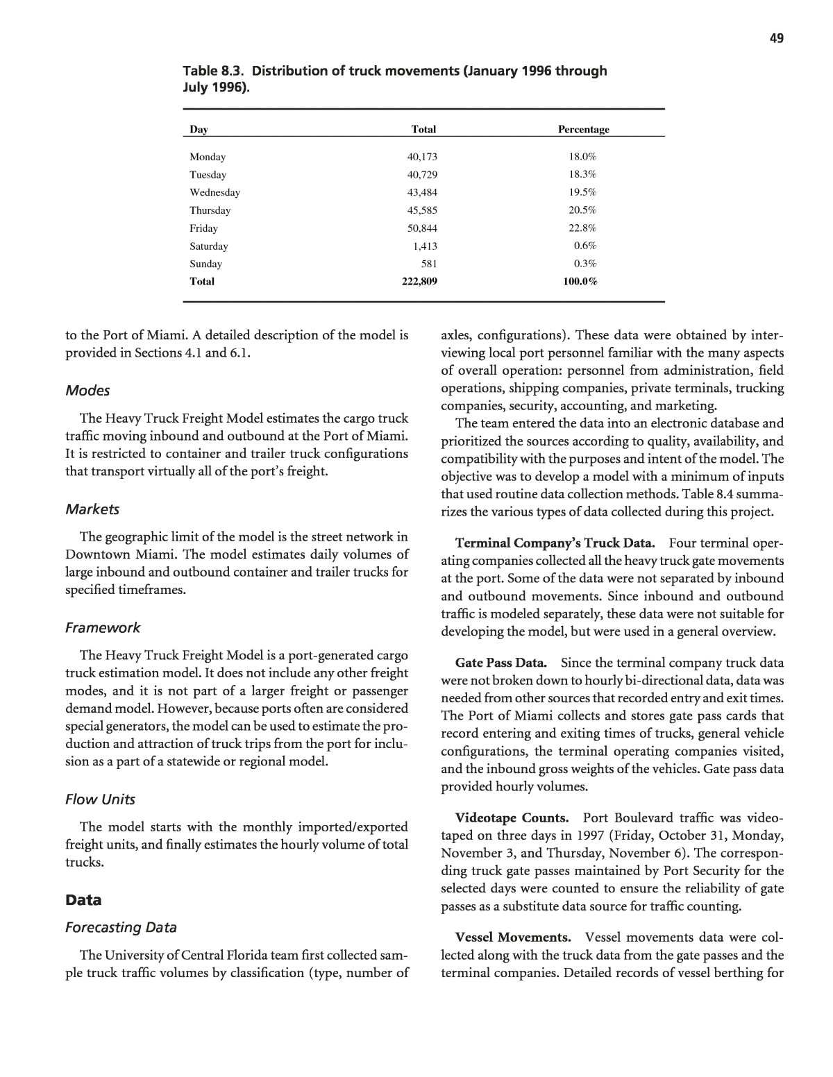
to the Port of Miami. A detailed description of the model is provided in Sections 4.1 and 6.1. Modes The Heavy Truck Freight Model estimates the cargo truck trafï¬c moving inbound and outbound at the Port of Miami. It is restricted to container and trailer truck conï¬gurations that transport virtually all of the portâs freight. Markets The geographic limit of the model is the street network in Downtown Miami. The model estimates daily volumes of large inbound and outbound container and trailer trucks for speciï¬ed timeframes. Framework The Heavy Truck Freight Model is a port-generated cargo truck estimation model. It does not include any other freight modes, and it is not part of a larger freight or passenger demand model. However, because ports often are considered special generators, the model can be used to estimate the pro- duction and attraction of truck trips from the port for inclu- sion as a part of a statewide or regional model. Flow Units The model starts with the monthly imported/exported freight units, and ï¬nally estimates the hourly volume of total trucks. Data Forecasting Data The University of Central Florida team ï¬rst collected sam- ple truck trafï¬c volumes by classiï¬cation (type, number of axles, conï¬gurations). These data were obtained by inter- viewing local port personnel familiar with the many aspects of overall operation: personnel from administration, ï¬eld operations, shipping companies, private terminals, trucking companies, security, accounting, and marketing. The team entered the data into an electronic database and prioritized the sources according to quality, availability, and compatibility with the purposes and intent of the model. The objective was to develop a model with a minimum of inputs that used routine data collection methods. Table 8.4 summa- rizes the various types of data collected during this project. Terminal Companyâs Truck Data. Four terminal oper- ating companies collected all the heavy truck gate movements at the port. Some of the data were not separated by inbound and outbound movements. Since inbound and outbound trafï¬c is modeled separately, these data were not suitable for developing the model, but were used in a general overview. Gate Pass Data. Since the terminal company truck data were not broken down to hourly bi-directional data, data was needed from other sources that recorded entry and exit times. The Port of Miami collects and stores gate pass cards that record entering and exiting times of trucks, general vehicle conï¬gurations, the terminal operating companies visited, and the inbound gross weights of the vehicles. Gate pass data provided hourly volumes. Videotape Counts. Port Boulevard trafï¬c was video- taped on three days in 1997 (Friday, October 31, Monday, November 3, and Thursday, November 6). The correspon- ding truck gate passes maintained by Port Security for the selected days were counted to ensure the reliability of gate passes as a substitute data source for trafï¬c counting. Vessel Movements. Vessel movements data were col- lected along with the truck data from the gate passes and the terminal companies. Detailed records of vessel berthing for 49 Day Total Percentage Monday 40,173 18.0% Tuesday 40,729 18.3% Wednesday 43,484 19.5% Thursday 45,585 20.5% Friday 50,844 22.8% Saturday 1,413 0.6% Sunday 581 0.3% Total 222,809 100.0% Table 8.3. Distribution of truck movements (January 1996 through July 1996).
1996 and 1997 were obtained from the daily dock reports, which include the entry and exit times and dates and various other data associated with berthing. Gantry Crane Activities. Gantry crane data for 1996 and 1997 were also collected. Detailed records of crane activities were extracted from the gantry crane activity by ship line reports maintained by the port. These data include the start time and end time of service for each vessel. Trailer/Container Activity Report. Trailer/container reports for the ï¬rst six months of 1997 were obtained from the Port Accounting Ofï¬ce. These data include the number of freight units (trailers and containers) moved on and off each vessel. Statistical Monthly Trailer/Container Performance Reports. Monthly trailer/container performance reports were obtained for the period October 1978 through April 1998. These data include monthly activity summaries and can be useful for determining historical trends in the trip gener- ation model input for long-term forecasts. Model Networks A layout of the external road network surrounding the Port of Miami is shown in Figure 8.3. This small region covers an area about one mile to the west of the port and is located within the central business district of Miami. The network covers the following roads: 50 Source of Data Resolution Period Terminal Company Gate Movements Daily Truck Movements January 1996-December 1997 Port of Miami Gate Passes Individual Truck Movements January 1997-May 1997a Video Counts Individual Truck Movements October 31, November 3, and November 6, 1997 Gantry Crane Activities Start Time and End Time January 1996-December 1997 Dock Reports Individual Vessel Arrival and Departure Times January 1996-December 1997 Trailer/Container Reports Daily Trailer/Container Totals January 1996-December 1997 Monthly Performance Reports Monthly Trailer/Container Totals October 1978-April 1998 a Only 57 days were collected. Table 8.4. Summary of data collected. Figure 8.3. Street network in the Port of Miami region.
1. Biscayne Boulevard northbound and southbound, between the Port Boulevard entrance and exit. 2. NE 5th Street between Biscayne Boulevard and NE 2nd Avenue. This is a one-way, eastbound roadway. 3. NE 6th Street between Biscayne Boulevard and NE 2nd Avenue. This is a one-way, westbound roadway. 4. NE 2nd Avenue between NE 6th Street and NE 5th Street. This is a one-way, southbound roadway. Model Development Data The project team experimented with various types of data to develop the model, ultimately determining that the daily number of freight units (containers and trailers) handled by the Port of Miami was the best-ï¬t independent variable. Conversion Data The model produces total daily heavy trucks using the total freight units. Validation Data The model was validated using 29% of the total available observations. The remaining 71% were used for developing the model. The model validation statistics are shown in the model validation section. Model Development The following methodology was used to develop truck trip generation model(s) for the Port of Miami: 1. Collect sample truck trafï¬c volumes by classiï¬cation (type, number of axles, conï¬gurations); 2. Interview local port personnel familiar with the many aspects of the overall operation, including personnel from administration, ï¬eld operations, shipping compa- nies, private terminals, trucking companies, security, accounting, and marketing; 3. Enter data samples into an electronic database, prioritiz- ing the sources according to quality, availability, and fea- sibility, with the objective of developing a model with minimum input and routine collection practices; 4. Determine the independent variables for formulating models to correlate the volume of freight truck move- ment with internal port activity, focusing on Port Boule- vard, the only road available for port access; 5. Develop the trip generation model by applying regres- sion analysis, with Port Boulevardâs daily directional truck volumes â inbound and outbound â as the depend- ent variables. Inbound refers to truck trips entering the port (the trip attraction model), while outbound refers to truck trips leaving the port (the trip production model); 6. Validate the model by entering survey data not used during the model formulation process; 7. Estimate gross weight of heavy truck movement gener- ated on Port Boulevard by applying regression model(s) with the monthly gross weight of cargo as the dependent variable and the cargo vessel freight unit volume; 8. Perform a time series analysis to examine long-term and seasonal trends applying the analysis to the monthly totals of the main independent variable, cargo vessel freight unit volume (containers and trailers); 9. Determine hourly distribution of truck movements from gate pass data; and 10. Interpret the results to establish conclusions and make recommendations for future analysis. Software No speciï¬c modeling or planning software was applied to develop this model. Standard statistical software was used to develop the regression equations and the ARIMA models. Commodity Groups/Truck Types The Heavy Truck Freight Model estimates total freight trucks. It does not segregate by commodity group or by purpose. Trip Generation The University of Central Florida research team used a process similar to trip generation to develop the factors and forecast variables in the model. The research team used dif- ferent equations and data to estimate inbound and outbound trafï¬c. Since the Port of Miami has a higher percentage of exports than imports, it was essential to distinguish between the inbound and outbound directions and apply the two components accordingly. The Heavy Truck Freight Model predicts the daily volumes of large inbound and outbound truck trips. As shown in equations 1 and 2, the inbound truck model component pre- dicts truck trips attracted to the port while the outbound model component predicts truck trip produced by the port activities. The dependent variables are the daily inbound and outbound loaded truck volumes, and the independent vari- ables are the total number of exported and imported freight units. The team also developed equations for forecasting future year inbound and outbound freight units, which are required to estimate future year truck trips. The team developed two 51
time series models, as shown in equations 3 and 4, and two regression models, as shown in equations 5 and 6. INTK â 1.197 * (EXPFU) (1) OUTK = 310.079 + 0.698 * (INPFU) (2) Ln (IMPFUm) = 0.0135 + Ln (IMPFUmâ1) â 0.218 (Ln(IMPFUmâ9) â Ln (IMPFUmâ10)) (3) Ln (EMPFUm) = 0.01275 + Ln (EMPFUmâ1) â 0.18 (Ln(EMPFUmâ9) â Ln (EMPFUmâ10)) (4) IMPFU = Exp (8.771 + 0.009506 (Month Index)) (5) EMPFU = Exp (8.767 + 0.00885 (Month Index)) (6) where: INTK = Inbound loaded freight truck volume; OUTK = Outbound loaded freight truck volume; IMPFU = Total imported freight unit; EXPFU = Total exported freight unit; Month Index = 1, 2, 3, 4, 5, etc.; and m = current month. Trip Distribution The model does not include a trip distribution step. Commodity Trip Table Since the model estimates the trip ends of a special gener- ator, it does not develop any trip tables. Mode Split The model estimates total trucks; the mode split step is not available in the model. Flow Unit and Time Period Conversion Assignment No assignment step was necessary in this model. Model Validation This is a ï¬ow factoring model, which does not include separate trip generation, trip distribution, mode choice, and trafï¬c assignment steps. This section describes the model validation statistics available in the research report. Tables 8.5 and 8.6 present the inbound and outbound linear regression models summary statistics. The R-squared values for the inbound (attraction) and outbound (production) mod- els indicate that the Heavy Truck Model explains almost 80% of the variability in the number of inbound loaded truck move- ments, and almost 70% of the variability in the number of outbound loaded truck movements (dependent variable). These two models are adequate to represent the relation- ship between the number of loaded truck movements and the number of freight units. To validate the Heavy Truck Freight Model, the team used a total of 20 observations (71% of the total available observa- tions) to ï¬t the regression component and eight observations (29% of the total available observations) to validate the com- pleted model. The team used a paired t-test to compare the total number of loaded freight trucks predicted by the model equations and their actual values. The results of these tests for both the inbound and outbound models are shown in Tables 8.7 and 8.8, respectively. There is no signiï¬cant difference between the predicted values and the observed values for both models at the 95% conï¬dence level. Model Application The most important application of the model is to fore- cast the daily and hourly truck movements for the future year. The following steps are needed to forecast daily truck volumes. 1. Forecast Monthly Imported/Exported Freight Units. Fore- cast imported and exported monthly freight units using time series ARIMA and regression equations. 52 Summary Statistics Regression Statistics Multiple R 0.8855865 R Square 0.7842635 Adjusted R Square 0.7316319 Standard Error 303.59594 SSE/Mean 0.2392403 Observation 20 Summary Statistics Regression Statistics Multiple R 0.82805933 R Square 0.68568225 Adjusted R Square 0.66822015 Standard Error 203.248744 SSE/Mean 0.20846025 Observation 20 Table 8.5. Inbound loaded freight trucks regression model statistics. Table 8.6. Outbound loaded freight trucks regression model statistics.
2. Forecast Weekly Imported/Exported Freight Units. Forecast the total number of weekly imported and exported freight units by multiplying the monthly number of freight units from Step 1 by the average percent of each week of the month. 3. Forecast for Each Group of Days. Forecast for each group of days by multiplying the weekly number of freight units resulting from Step 2 by the average percentage of each group. 4. Forecast Loaded Trucks for Each Group of Days. Forecast the total number of loaded trucks generated by the Port of Miami for each group of days for each direction by applying the attraction and the production models developed. 5. Forecast for Each Day of the Week Within Each Group. Estimate the daily number of inbound and outbound loaded freight trucks by multiplying the regression model results for the number of loaded trucks for each group by the average of truck movement percentage for each day of the week. 6. Forecast Hourly Truck Volumes. Estimate the total hourly volume of trucks by using the results from Step 5 and mul- tiplying these ï¬gures by the percentages of trucks for each hour. Performance Measures and Evaluation Not developed for this model. 53 Paired t-Test Actual Predicted Mean 1,148 1,225 Variance 417,489 417,474 Observations 8 8 Pearson Correlation 0.81 Hypothesized Mean Difference 0 Df 7 T Stat -0.55 P (T<=) One-Tail 0.30 T Critical One-Tail 1.89 P (T<=) Two-Tail 0.60 T Critical Two-Tail 2.36 Table 8.7. Statistical comparison between the observed total number of inbound loaded freight trucks and the predicted values by the attraction regression model. Paired t-Test Actual Predicted Mean 1,004 906 Variance 57,150 104,258 Observations 8 8 Pearson Correlation 0.86 Hypothesized Mean Difference 0 Df 7 T Stat 1.61 P (T<=) One-Tail 0.08 T Critical One-Tail 1.89 P (T<=) Two-Tail 0.15 T Critical Two-Tail 2.36 Table 8.8. Statistical comparison between the observed total number of outbound loaded freight trucks and the predicted values by the production regression model.
8.4 Case Study â Ohio Interim Freight Model Background Context Federal regulations call for speciï¬c consideration of freight in the development of statewide plans and programs as a con- dition of Federal funding. This requirement obliged the Ohio Department of Transportation (ODOT) to address freight in its 2002 update of Access Ohio, its statewide transportation plan. Although ODOT was in the process of developing a comprehensive, statewide, travel demand forecasting model that would include sophisticated freight-planning capabili- ties, an interim study was needed until the new model was fully functional, sometime in 2005. The interim freight study was designed to provide infor- mation and tools to assess freight trends and impacts on Ohioâs roadways.18 The data developed was used in four indi- vidual Ohio case studies each addressing a different aspect of freight movement. The model associated with the study is referred to here as the Ohio Interim Model. Figure 8.4 shows existing truck ï¬ows on Ohio highways. The model developed in the interim study produces esti- mates of freight truck volumes that match the pattern and magnitude of all existing truck volumes in Ohio, but with the additional ability to identify the characteristics of those freight movements (origin, destination, payload, value, com- modities carried, etc.). The model is easy to maintain and adapt and uses standard inexpensive commercially available software. It is compatible with the forecasts of freight move- ments being developed nationally for the Federal Highway Administration. The forecasts of truck trafï¬c developed from an annual survey of shippers produce a broader geographic distribution of truck trafï¬c than is produced by a factored roadside intercept survey. Objective and Purpose of the Model The purpose of the Ohio study was to determine how read- ily available freight databases could be used to: ⢠Provide ODOT with a clear picture of existing and future freight movements on Ohioâs most critical highway corridors; 54 Figure 8.4. Ohio highway truck ton flows.
⢠Forecast freight ï¬ows and assess the impact that future changes in the freight system and freight movement may have on Ohioâs roadways; and ⢠Make recommendations to meet these demands, while maintaining Ohioâs strong economic growth. General Approach Model class The Ohio Interim Freight Model developed facility freight ï¬ows by directly obtaining and factoring an O-D table of commodity freight ï¬ows, splitting the commodity ï¬ow to modes based on existing shares or a market segmentation diversion method, and assigning the modal O-D tables to modal transportation networks using ï¬xed paths. The research study found that the O-D tonnage information could be converted to daily trucks and mapped to Ohioâs roadways. A detailed description of the O-D factoring method is provided in Section 6.2. Modes The model was primarily developed to address truck movements on major highways, but includes water, air, and two rail submodes (carload rail and intermodal containers). Existing and future commodity ï¬ows were summarized by mode share (truck, rail, water, air) and were presented by weight, value, direction (inbound/outbound), origin, and destination. Markets The model was developed to address freight issues throughout the state of Ohio and included information on the top 13 truck commodities. Key trading partners (states and regions) were identiï¬ed. The four Ohio case studies addressed different markets. The methods do not produce estimates of the shipments of nonmanufactured goods, local delivery trucks, construction trucks, service trucks, and other heavy vehicles not involved in the shipment of freight. The forecasts of these localized truck volumes must be obtained elsewhere. Framework The purpose of the model and the study was to address Ohioâs needs for interim freight information and tools to assess freight trends and impacts on Ohioâs roadways while ODOT updates its statewide travel demand model. When complete, the updated statewide model will include more sophisticated freight planning capabilities. Flow Units Existing and future commodity ï¬ows were summarized by mode share (truck, rail, water, air) and were presented by weight, value, direction (inbound/outbound), origin, and destination. Additionally conversion factors were applied to convert tonnage by trucks into annual trucks and then to daily truck trips. Data Forecasting Data BASE AND FORECAST YEAR SOCIOECONOMIC DATA The Ohio Interim Freight Model used the 1998 TRANSEARCH database of freight shipments traveling to, from, or through Ohio. Forecasts of Ohioâs economy were obtained from the ï¬rm of DRI-WEFA and used to estimate freight ï¬ows for the year 2025. EXTERNAL MARKETS An assessment of intrastate and through freight move- ments is included in the model. The rail network included the entire country and the highway network included only Ohio highways, with external stations at the state boundaries. Modal Networks FREIGHT MODAL NETWORKS Shapeï¬les provided with the TRANSEARCH network were used to assign freight ï¬ows. INTERMODAL TERMINAL DATA The information in the commodity ï¬ow database was at the county level. No information was available for zones rep- resenting intermodal terminals. Model Development Data No model coefï¬cients or parameters were necessary in the Ohio Interim Freight Model. Conversion Data CONVERSION OF TONNAGE INTO VALUE Factors to convert annual tonnage into annual value were developed from the CFS conducted by the U.S. Bureau of the Census and the U.S. Department of Transportation. The 1993 Commodity Flow Survey, which reports commodities by 55
STCC, was chosen in order to be consistent with TRANSEARCH. The 1997 CFS reports commodities by the newer SCTG codes that are not directly transferable to STCC at a two-digit level. The values per ton were converted to 1998 dollars using the consumer price index. CONVERSION OF TRUCK TONNAGE INTO DAILY TRUCK TRIPS Factors to convert annual tonnage into annual trucks trips were developed from the VIUS conducted by the U.S. Bureau of the Census. The VIUS national microdata database con- sists of 105,545 records, with 1,974 records of the trucks based in Ohio. Of these, 1,399 included loaded weight information that make it possible to develop average payloads for the two-digit STCC codes included in the Ohio TRANSEARCH database. The sample includes expansion factors that equate to over 82 billion ton-miles of shipments. Validation Data The estimates of daily freight trucks produced by TRANSEARCH were qualitatively compared with ODOTâs volume counts for all trucks. Model Development Methods were developed to assign the ï¬ow of freight ship- ments to Ohioâs major roadway using database queries within TRANSEARCH. The resulting network ï¬ows were then mapped as a roadway network using the ArcView GIS software. The Ohio Interim Freight Model developed facility freight ï¬ows by directly using a method of freight forecasting described as O-D table factoring and assignment. This method (with some variation) has been used by many states. The most prevalent application of this method follows these general steps: 1. Obtain base-year O-D tables (in tons per year) by com- modity and by mode that matches the desired trafï¬c zone system. Typically, ï¬ows between external zones that do not pass though the internal portions of the network are excluded. (For the Ohio Interim Freight model 1998 TRANSEARCH databases were used.) 2. Obtain base-year and future-year levels of economic activity (by industrial sector) for all zones. (For the Ohio Interim Freight Model, forecasts of Ohioâs economy were obtained from DRI-WEFA and used to estimate freight ï¬ows for the year 2025.) 3. Establish a mapping between industrial sectors and com- modity categories, such that a percent increase in an industrial sector can be associated with a percent increase in a commodity. (For the Ohio Interim Freight Model, the Ohio data contained 40 separate classiï¬cations by STCC codes, but the separate codes were aggregated into the top 13 commodity codes.) 4. Determine the percent increase in each commodityâs ori- gins and destinations by applying growth factors obtained in Steps 2 and 3. 5. Apply Fratar factoring to each O-D table to achieve the percent increases determined in Step 4. 6. Determine the number of vehicles necessary to carry each O-D ï¬ow for one equivalent weekday. 7. Assign each factored vehicle trip table to its respective modal network. This method assumes that the mode split for any given commodity and for any given O-D pair is a constant. Any modal shifts that occur in this method are due to economic growth (or decline) or spatial shifts in economic activity and the resulting effects on commodity production and con- sumption patterns. Shifts due to changes in costs, supply chain practices, shipping and transfer times or vehicle tech- nology are not included. The method further assumes that the production, con- sumption, and shipping characteristics of commodities remain unchanged. Such assumptions can be eliminated by careful consideration of changes in a) shipping density of commodities, particularly due to packaging materials; b) worker productivity when economic activity forecasts are given in number of workers in an industry; c) value per ton when economic activity forecasts are given in monetary units; d) the routing patterns of the supply chain; and e) competi- tiveness of modes or intermodal combinations to carry speciï¬c commodities. Software The Ohio Interim Freight Model was developed using sev- eral software packages readily available and familiar to trans- portation professionals. These included Microsoft Access, Microsoft Excel, ArcView GIS, and the Highway Economic Requirements System (HERS). While Access and Excel are common software packages, ArcView GIS and HERS typi- cally require specialized knowledge. By using Access queries, truck ï¬ows by highway segment can be exported in DBF format for use in other programs. Maps of truck ï¬ows can be prepared from the DBF ï¬le of ï¬ows by highway segment ID using ArcView. TRANSEARCH contains a shapeï¬le containing all the information in the highway network. By joining the highway segment ï¬eld in the DBF ï¬le with the same ï¬eld in the network shape ï¬le, maps of the ï¬ows can be produced. 56
Commodity Groups/Truck Types Commodity groups serve a function similar to trip pur- poses in the passenger travel demand models. The TRANSEARCH commodity database purchased for Ohio includes 40 separate classiï¬cations of commodities by STCC code at the two-digit level and 440 separate classiï¬cations at the four-digit level. While this level of detail is useful for iden- tifying speciï¬c commodity movements, such a large number of commodity classiï¬cations makes reporting and analysis difï¬cult. In order to reduce the commodity groups to a more manageable level, the top 13 commodities at the two-digit STCC level by tonnage were identiï¬ed. These 13 represent over 93% of the truck tonnages by truck as well as 86% of the total tonnage originating in Ohio. These STCC codes were each assigned as a single commodity group for analysis and reporting purposes. The remaining commodities were as- signed to groups in the following categories: agricultural products, other nondurable manufactured products, other durable manufactured products, minerals, and miscellaneous freight. The commodity groups for the model are shown in Table 8.9. Shown in each row are the STCC commodities assigned to each group and the total tonnage reported as traveling in Ohio by all modes and by truck. The commodity groups are organ- ized in the order of the numeric STCC code that they represent, not by the amount of tonnage represented by that group. These commodity groups serve as the basis for the report and accompanying tables. Tables 8.9 and 8.10 do not include non- manufactured goods. For example, agricultural products transported to a food processing plant are included, but agri- cultural products transported to a supermarket are not. Trip Generation Not applicable. The Ohio Interim Freight model used TRANSEARCH origin/destination data as purchased for this particular study. Trip Distribution Not applicable. The Ohio Interim Freight Model used TRANSEARCH origin/destination data as purchased for this particular study. Commodity Trip Table The Ohio Interim Freight Model used TRANSEARCH O-D data as purchased for this particular study. 57 Commodity Group Code Name STCC Codes in Commodity Group 1998 Annual Tonnage by All Modes 1998 Annual Tonnage by Truck 1 Agriculture 1, 7, 8, 9 28,898,426 6,679,545 2 Metallic Ores 10 43,887,516 â 3 Coal 11 132,797,767 11,135,211 4 Other Minerals 13, 14, 19 26,096,634 â 5 Food 20 96,036,220 76,781,243 6 Nondurable Manufacturing 21, 22, 23, 25, 27 13,311,467 12,646,266 7 Lumber 24 27,041,926 22,128,079 8 Paper 26 31,175,374 24,416,542 9 Chemicals 28 94,527,499 66,666,943 10 Petroleum 29 46,791,003 29,842,434 11 Rubber/Plastics 30 18,797,786 18,442,466 12 Durable Manufacturing 31, 36, 38, 39 23,187,380 22,128,609 13 Clay, Concrete, Glass 32 70,984,985 64,114,794 14 Primary Metals 33 87,342,217 62,115,438 15 Fabricated Metal Products 34 27,871,702 27,107,319 16 Transportation Equipment 37 47,048,025 31,064,887 17 Miscellaneous Freight 40-48, 5020, 5030 43,143,468 â 18 Warehousing 5010 82,420,938 82,420,938 Table 8.9. Commodity groups used in the Ohio Interim Freight Model.
The annual tonnage data from TRANSEARCH were con- verted into annual values based on factors from the CFS. The annual tonnage data from TRANSEARCH also were con- verted into number of annual trucks based on VIUS. The number of annual trucks was disaggregated into the number of daily truck trips. To simplify summary analysis and report- ing, the 40 separate classiï¬cation categories of two-digit STCC codes were grouped into the top 13 commodities. Future freight ï¬ows for each commodity group were deter- mined based on economic model forecasts for 2010 and 2020. Using the TRANSEARCH database, truck ï¬ows on individ- ual highway segments, including origin, destination, and commodity type, can be exported into a DBF ï¬le and then mapped to Ohioâs roadways. The economic model used in this study consisted of a set of unique commodity ï¬ow models that specify the likely pat- tern of goods movement by commodity and by transport mode. The forecasts are based on economic factors that affect changes in demand. The projections are based on regional, industry, and commodity models and have been developed to support a variety of public agencies and private ï¬rms study- ing freight transportation. 58 Distance Class Two-Digit STCC Codes Commodity Name Local (<50 Miles) Short (50 to 100 Miles) Short- Medium (100 to 200 Miles) Long- Medium (200 to 500 Miles) Long (>500 Miles) 1 Farm Products 12.04 18.37 19.10 18.71 17.67 8 Forest Products 13.36 11.64 13.27 13.27 13.27 9 Fresh Fish or Marine Products 8.20 8.13 14.42 15.89 16.11 10 Metallic Ores 16.98 18.81 25.77 25.77 25.77 11 Coal 16.98 18.81 25.77 25.77 25.77 13 Crude Petroleum or Natural Gas 14.43 19.58 17.84 17.84 17.84 14 Nonmetallic Minerals 16.98 18.81 25.77 25.77 25.77 19 Ordnance or Accessories 7.05 4.42 11.47 9.84 11.30 20 Food or Kindred Products 8.20 8.13 14.42 15.89 16.11 21 Tobacco Products 11.50 16.25 16.03 11.47 15.96 22 Textile Mill Products 1.34 3.57 18.18 18.16 17.48 23 Apparel or Related Products 1.34 3.57 18.18 18.16 17.48 24 Lumber or Wood Products 10.33 12.35 17.50 17.61 17.83 25 Furniture or Fixtures 2.92 3.25 11.02 11.26 11.38 26 Pulp, Paper, or Allied Products 4.07 7.67 15.66 15.17 14.59 27 Printed Matter 4.07 7.67 15.66 15.17 14.59 28 Chemicals or Allied Products 5.18 15.39 19.55 19.25 19.25 29 Petroleum or Coal Products 14.43 19.58 17.84 17.84 17.84 30 Rubber or Miscellaneous Plastics 7.05 4.42 11.47 9.84 11.30 31 Leather or Leather Products 1.34 3.57 18.18 18.16 17.48 32 Clay, Concrete, Glass, or Stone 10.69 14.47 18.53 18.63 18.81 33 Primary Metal Products 11.82 14.73 19.96 20.14 20.13 34 Fabricated Metal Products 4.00 11.33 14.49 14.49 14.49 35 Machinery 6.97 12.55 17.42 17.21 17.21 36 Electrical Equipment 4.05 7.42 14.81 14.62 14.62 37 Transportation Equipment 2.48 14.12 17.21 16.92 14.18 38 Instruments, Photo Equipment, Optical Equipment 6.97 12.55 17.42 17.21 17.21 39 Miscellaneous Manufacturing Products 5.48 5.40 11.63 13.04 14.23 50 Drayage, Warehousing, Distribution 7.05 9.67 14.85 14.98 14.93 Source: Derived from Vehicle Inventory and Usage Survey records for Ohio. Table 8.10. Ohio tonnage to truck conversion factors (tons per truck).
Mode Split The base year split among highway, rail, air, and water modes from TRANSEARCH was assumed too constant into the future for the Ohio Interim Freight Model. However, a mode split by market segmentation used to assess potential freight diversion between highway and rail was developed for the Northern Ohio Rail Highway Corridor case study. This case study addressed an important issue in Ohioâs state planning by assessing the potential to reduce the number of trucks travel- ing on the turnpike and the parallel alternate highway routes. It was assumed that only trips longer than a certain length, car- rying only particular commodities, and larger than a certain size (weight) would be suitable for diversion to rail. Speciï¬- cally, three major characteristics that inï¬uence the diversion potential were analyzed: 1) the origin and destination of the trafï¬c; 2) the commodity mix of trafï¬c between these origins and destinations; and 3) the total distance between them. Flow Unit and Time Period Conversion The VIUS microdata includes the empty weight of the vehicle; the average loaded weight of the vehicle; expansion factors based on the miles traveled; the percentage of the miles that the vehicleâs trip falls in one of ï¬ve different dis- tance-classes; the percentage of the miles that the vehicle is empty; and, when full, the percentage of the miles that the vehicle is used to carry 31 distinct product classes. Average payloads were calculated by the ï¬ve distance- classes established in VIUS: 1) local (less than 50-mile trips); 2) short (50- to 100-mile trips); 3) medium-short (100- to 200-mile trips); 4) medium-long (200- to 500-mile trips), and 5) long (over 500-mile trips). The payloads were calculated by distance-class because the average payload and truck size var- ied by distance-class. Shorter-distance trips tend to be domi- nated by single unit trucks, which carry smaller average payloads. Longer-distance trips are dominated by combina- tion tractor-trailer trucks, which carry larger average payloads. The product classes used by the VIUS are similar to the two- digit STCC codes established for TRANSEARCH. The VIUS survey records the percentage of the mileage that a truck is car- rying certain products, equipment, materials, etc. âNo Loadâ is treated by VIUS as a separate product category. VIUS also includes buses and service trucks in the survey. Thus, certain VIUS product categories do not correspond to STCC com- modity classes. A correspondence between the VIUS product classes and the Ohio Model commodity groups was devel- oped. Passenger and service truck product classes not included in the commodity data (for example, Craftsmenâs Tools or Household Possessions) were excluded. The weighted annual mileage for each VIUS product car- ried by distance-class was calculated for each record in the Ohio VIUS database. The mileage was multiplied by the average payload for that record to obtain weighted annual ton-miles by product class and by distance-class for each record. The weighted annual ton-miles, and the weighted annual miles were summed over all records. The average pay- load for each commodity by distance-class was obtained by dividing average annual ton-miles by average annual miles. Calculating payloads by two-digit STCC code is the ï¬rst step in developing factors to convert tonnage to trucks. This payload does not include the percentage of miles that a truck travels empty. This percentage of empty miles by commodity group can also be calculated from the VIUS âNo Loadâ prod- uct class. The factor to be used to covert from annual tonnage to annual trucks must account for the average payload, including percentage of empty trucks, in each STCC com- modity class. The values by STCC code and distance-class are given in Table 8.10. After converting annual tons to annual trucks, the result- ing annual truck trip table is converted into a daily truck trip table. The Highway Capacity Manual (HCM) suggests that an average truck working week consists of ï¬ve weekdays at full capacity and two weekend days at 44% capacity.19 This equates to 306 truck working days per year. In addition, six Federal holidays are excluded from working calculations. It is recommended that the annual truck trips should be divided by 300 average weighted truck working days to calculate daily truck trips. The 1993 CFS values were used to develop value per ton by STCC code. The values per ton are reported in Table 8.11. The Ohio model converted the observed tonnages to val- ues and annual trucks. The Ohio model used 306 working days per year to convert from annual to daily trucks. Assignment The assignment process used a predetermined, ï¬xed path routing method based on the National Highway Network (NHN) as developed by the Oak Ridge National Laboratory. Reebie Associates has used routing information in the NHN to develop a database of highway segments that form the paths between the geographic centers of each county in the United States. Ohioâs purchase of TRANSEARCH includes routing information showing all highway paths used within a state. The national O-D table of commodity ï¬ows between counties in the United States is aggregated into the speciï¬c regions developed as part of Ohioâs TRANSEARCH database. While the tonnage ï¬ow information is aggregated to these regions, groupings also are maintained by highway path, with origin, destination, and commodity information attached. Total truck ï¬ows on individual highway segments can be identiï¬ed and selectively chosen to show origin, destination, 59
or commodity. By using the query capabilities of Microsoft Access, these ï¬ow records by highway segment can be exported as a DBF ï¬le for use in other programs. Maps of truck freight flows can be prepared from the DBF file of flows by highway segment ID using ArcView. TRANSEARCH contains a shapefile containing all of the information in the highway network. By joining the highway segment ï¬eld in the DBF ï¬le with the same ï¬eld in the net- work shapeï¬le, maps of the ï¬ows can be produced. Model Validation Trip Generation No trip generation validation was conducted. Trip Distribution No trip distribution validation was conducted. Mode Choice No mode choice validation was conducted. Modal Assignment The modal assignment was validated by comparing the estimates of daily freight trucks produced by TRANSEARCH with the Ohio DOTâs truck volumes. Comparisons were made between the pattern of the modeled freight truck vol- umes and the observed truck volumes crossing screenlines. 60 STCC Code Description Value Per Ton (1998$) 1 Farm Products $1,147 8 Forest Products $40 9 Fresh Fish or Other Marine Products $5,493 10 Metallic Ores $50 11 Coal $24 13 Crude Petroleum, Natural Gas, or Gasoline $31 14 Nonmetallic Minerals $19 19 Ordnance or Accessories $11,590 20 Food or Kindred Products $1,408 21 Tobacco Products, Excluding Insecticides $32,610 22 Textile Mill Products $6,735 23 Apparel or Other Finished Textile Products $25,732 24 Lumber or Wood Products, Excluding Furniture $2,363 25 Furniture or Fixtures $5,465 26 Pulp, Paper, or Allied Products $1,333 27 Printed Matter $3,054 28 Chemicals or Allied Products $2,064 29 Petroleum or Coal Products $239 30 Rubber or Miscellaneous Plastics Products $7,290 31 Leather or Leather Products $29,268 32 Clay, Concrete, Glass, or Stone Products $205 33 Primary Metal Products $1,273 34 Fabricated Metal Products $3,544 35 Machinery, Excluding Electrical $21,980 36 Electrical Machinery, Equipment, or Supplies $28,724 37 Transportation Equipment $13,904 38 Instruments, etc. $39,343 39 Miscellaneous Products or Manufacturing $11,270 40 Waste or Scrap Materials $26 41 Miscellaneous Freight Shipment $4,763 42 Containers Returned Empty $1,120 43 Mail and Contract Traffic $1,333 45 Freight Forwarder Traffic $1,606 46 Mixed Commodity Shipments $1,606 47 Small Packages $1,606 48 Waste Hazardous Materials $291 49 Hazardous and Corrosive Materials $2,064 50 Secondary Cargos and Drayage $1,606 99 Commodity Unknown $8,917 Source: Derived from the Commodity Flows Survey records from Ohio. Table 8.11. Shipment values per ton by STCC commodity.
The pattern of truck volumes estimated by TRANSEARCH was mapped using ArcView and was overlaid on the map of ODOT truck volumes. The TRANSEARCH freight truck ï¬ows include only a subset of all heavy trucks counted by ODOT. They include only trucks involved in the private or for-hire transport of freight, not service trucks, construction trucks, local delivery trucks, etc. On rural interstate facilities, where freight trucks predominate, the difference between observed truck volumes and TRANSEARCH freight trucks is minimal. On urban highways, where urban activity generates signiï¬cant additional trucking activity, the differences are greater. Generally, freight trafï¬c at the statewide level repre- sents 60% or more of all truck vehicle-miles of travel. The selected Ohio screenline locations generally show a re- lationship between the total observed and the total estimated truck volumes within the expected levels. The variation exists because the truck observations include all types of trucks while the estimate is of one type of truck: trucks carrying freight. In rural areas, freight trucks will constitute almost 100% of all trucks. In urban areas, the percentage is much lower. The estimated truck volumes were derived by assigning truck ï¬ows to the single shortest highway path between county centers. TRANSEARCH does not take into account diversion of trafï¬c among several available routes, nor can it distinguish shortest paths from points not at the county cen- ters. As such, the TRANSEARCH ï¬ows are best considered general ï¬ows along a corridor rather than actual facility ï¬ows. Model Application The Ohio Interim Freight Model freight data was used in four case studies to address various freight operations and policy issues. Each of these case studies is described below. Macro-Corridor Case Study OVERVIEW This case study examined Ohioâs macro-corridors and the impact of an increase in truck trafï¬c that is greater than the expected increase in trafï¬c. The 1995 Ohio State Transportation Plan Access Ohio, identiï¬ed âTransportation Efï¬ciency and Economic Ad- vancement Corridors,â also known as macro-corridors, throughout the state. Macro-corridors form a network of approximately 2,300 miles of roads determined to be the most critical. One of the factors used in the designation of a macro-corridor is high truck volumes. Based on the analysis of the Ohio model outputs, those macro-corridors were found to carry over 96% of the freight-truck volumes. Truck trafï¬c on these corridors was found to be growing at an annual rate of 2.3%, faster than the 2.0% annual growth rate of general trafï¬c on these same corridors. This caused ODOT to express concern about performance and funding. The macro-corridors in Ohio were evaluated using the Highway Economic Requirements System model and the PONTIS bridge management model. These models represent the state-of-the-practice in evaluating highway and bridge systems and rely on databases that are prepared by the states. For HERS, the Highway Performance Monitoring System data prepared annually by ODOT and submitted to the U.S. DOT was used. (No analysis was undertaken using PONTIS. Previous analysis with PONTIS in other states has indicated that bridge costs and conditions vary little with changes in demand and are instead a function of environmental and maintenance factors. For that reason, the case study was performed using only HERS.) HERS analysis provided data on congestion, speeds, pavement conditions, safety, air pol- lution, and program expenditures. CONCLUSIONS ⢠The impacts caused by the growth in truck trafï¬c, which is greater than the comparable increase in general trafï¬c, are minimal and should be manageable. ⢠According to HERS, the costs to maintain the existing sys- tem are considerable, but not appreciably greater, when adjusted for growth, than Ohioâs current expenditures. Trucks are responsible for a large share of those costs â approximately 30% according to relationships in the High- way Cost Allocation Study. ⢠HERS produced reasonable and useful results for this study. ODOT is currently testing HERS/ST, a specially tailored version for state DOTs, and should be encouraged to implement the software. ⢠HERS considers only the direct beneï¬ts to users of the highway system. It does not consider the economic devel- opment impacts of changes in transportation costs. The changes in these costs are available from HERS and consid- eration should be given to applying economic models to identify the larger impacts on Ohioâs economy. I-75 Corridor Case Study OVERVIEW This case study examined how improved truck forecasts might be utilized in a corridor planning study. The freight- truck forecasts provide detailed information about the industries served and commodities carried now and in the future on Interstate 75 in Ohio. I-75 is one of the major trucking corridors in the United States, running from Miami to Detroit and continuing as 61
Highway 401 to Toronto. I-75 has been the subject of the multi-state I-75 Advantage Program to reduce congestion, increase efï¬ciency, and enhance the safety of motorists and other users through the application of Intelligent Transporta- tion System (ITS) technologies. ODOT was a major partner in the I-75 Advantage Program. During the preparation of the I-75 study, ODOT became concerned about the accuracy of the truck information on I-75. The data, forecasts, and methods developed as part of this freight study were examined to determine how they could be used in the I-75 study. The truck data and forecasts can provide detailed information about the industries served and commodities carried on I-75, both now and in the future. CONCLUSIONS ⢠Analysis indicates that of the top ï¬ve commodities carried ranked by value, four are industrial commodities (trans- portation equipment, general machinery, electrical machinery, and fabricated metal), which account for 28% of the value of freight carried on I-75. This information can help identify those industries and ï¬rms that will beneï¬t from I-75 improvements. ⢠The truck forecasts for I-75 are speciï¬c to the economic forecasts, not historic trends, and are available for individ- ual sections. In general, I-75 truck volumes are expected to increase by 1.8% per year. This growth is below the aver- age growth of 2.3% per year forecast for all roads in Ohio. These forecasts can support speciï¬c truck-related design considerations. ⢠By providing O-D information for trucks using I-75, the demand for interchanges in speciï¬c counties can be iden- tiï¬ed. The analysis indicated that the major interchanges of I-75, from north to south, include I-280, I-475, U.S. 68, U.S. 36, I-70, SR 43, Ronald Reagan Highway in Hamilton County, and I-71. The interchanges refer generally to the urban principal arterials and are consistent with the corri- dor level of the TRANSEARCH assignment procedures. The relative growth in truck percentages can support truck-speciï¬c design considerations at interchanges. ⢠Key features on major interstate highways are weigh sta- tions and rest areas. These facilities are particularly impor- tant for trucks traveling on I-75 without an Ohio origin or destination and for trucks traveling over 500 miles. The truck forecasts for 2020 indicate that 28% of the trucks on I-75 are passing though. The truck forecasts for 2020 fur- ther indicate that 30% of the freight trucks are traveling more than 500 miles and may require a driver rest stop. This information can support the sizing of weigh stations and indicates the relative need for rest areas. It cannot sup- port the detailed location of rest areas, since that determi- nation requires knowledge of the national origin and des- tination of trucks, their temporal movement over the national network, and the hours-of-service rules. These issues are beyond the scope of this study. ⢠The truck forecast supports the identiï¬cation of speciï¬c industries and geographic areas served by corridors (such as I-75) that can assist in public outreach and economic development efforts. Northern Ohio Corridor Case Study OVERVIEW This case study in northern Ohio examined the relative share of 1998 trafï¬c in the Northern Ohio Corridor among truck trafï¬c on the Ohio turnpike, truck trafï¬c on Ohio arte- rial highways, and rail trafï¬c and the factors that might inï¬u- ence diversion among these modes. The case study attempted to answer several important questions related to Ohioâs state planning: Would it be pos- sible, and feasible, to lessen the number of trucks traveling on the turnpike and the parallel alternate highway routes? Could enough trafï¬c be diverted to rail to warrant a public invest- ment in rail infrastructure and operations, or to offer other incentives to shippers or rail carriers? Is diversion even an issue that can be controlled and managed within the geo- graphic scope of the stateâs borders? Although there were no simple answers, there were ways to analyze freight ï¬ow data to intelligently explore the issues surrounding the Northern Corridor, and methodologies were in place to help determine how many trucks might be diverted in this corridor. Given the nature of the corridor, it could also be assumed that no diversion would take place to water or air freight. The current proï¬le of trafï¬c in the corridor became the basis for trafï¬c diversion estimates. The current mix of trafï¬c on the Ohio Turnpike and the alternative east-west corridors was analyzed in an effort to determine if the trafï¬c exhibits characteristics favorable for diversion to rail. Speciï¬cally, three major factors that inï¬uence diversion were analyzed. These were: 1) the origin and destination of the trafï¬c; 2) the com- modity mix of trafï¬c between these O-D points; and 3) the total distance between these points. CONCLUSIONS ⢠There are an estimated 13.6 million annual truckloads traveling in the Northern Ohio Corridor. ⢠The current intermodal rail market carries 7.3% of all loads in the corridor. 62
⢠The potential divertible market, including only loads with a distance and commodity that is likely to divert, is 2.1 mil- lion annual tons presently carried by trucks. ⢠The estimated annual truck tonnage that would be diverted to rail if rail costs decreased by 10% is 300,000, or 15% of the total divertible market segment and 2.2% of all freight truck loads in the corridor. ⢠The diversion analysis would not be possible without the commodity and O-D information available from Ohioâs TRANSEARCH database. ⢠Because most of the divertible market had origins and des- tination outside of the state, Ohio should form coalitions with other states to address rail and trucking issues. Mid-Ohio Regional Planning Commission Case Study OVERVIEW This case study examined how statewide freight-truck in- formation might be applied in improving the travel demand models at a regional and metropolitan level. MPO-supported travel demand models in Ohio generally forecast truck trips at external stations by extending the trend of observed historical growth. This method of forecasting the external-external truck trips passing through the MPO or the external-internal truck trips between the MPO and areas out- side the MPO suffers from an important weakness: It is not sensitive to economic changes outside of the MPOâs bound- aries. The Microsoft Access-supported TRANSEARCH freight-truck database was examined to determine whether the forecasts of truck trafï¬c in that database could be used to improve the modelâs forecasts of truck trips. In order to test this process, the Mid-Ohio Regional Planning Commission (MORPC), the MPO for the Columbus urban area, was selected to evaluate such a process. CONCLUSIONS ⢠Freight-truck trip tables can be converted to a standard travel demand model package, such as TRANPLAN, and the information can be extracted for a speciï¬c region. ⢠Reasonable expansion factors can be developed to convert the county-level trip table to the TAZ system supported by a metropolitan region. ⢠The truck forecast is particularly valuable for external sta- tions, which are generally problematic in regional forecast- ing processes and often are forecast based only on historical trends. However, because the number of exter- nal stations that have substantial volumes in the subarea freight truck trip table is fairly limited, the most appropri- ate use of the freight truck forecasts may be to qualitatively guide the adjustment of the modelâs external forecasts. ⢠The converted truck trip table is valuable in identifying and planning for major regional freight corridors and termi- nals. In addition, the complete statewide freight model can identify the routing and demand for regional trucks on the entire Ohio system. For example, the relative importance of I-71 in Cleveland to trucking in the MORPC region can be identiï¬ed. The freight-truck trip table and assignment represent only a small portion of the total truck movement in a region. They do not include local delivery, construction truck, service trucks, etc. The need to forecast these truck trips at the regional level will remain. Performance Measures and Evaluation Performance measures were not developed in the Ohio Interim Freight Model. 8.5 Case Study â Freight Analysis Framework Background Context The FHWAâs Ofï¬ce of Freight Management and Opera- tions has developed the FAF as a policy tool to estimate com- modity ï¬ows and related freight activity at national, state, and county levels. FAF not only covers domestic freight move- ments, but major international freight movements as well. The tool has been developed to provide an accurate, compre- hensive forecast of commodity ï¬ows and freight activity for the analysis years 1998, 2010, and 2020. These forecasts are sensitive to changes in economic conditions, the transporta- tion system, and other factors. Objective and Purpose of the Model The FAF provides the U.S. Department of Transportation with a policy analysis tool to help it understand commodity ï¬ows and the pressures these ï¬ows place on the transporta- tion system. A better understanding of goods movement helps the agency identify deï¬ciencies in the transportation infrastructure and formulate the means to address them. The FAF was developed initially for use as a national pol- icy analysis tool but has proven to be useful at other levels as well. Although it can never replace more detailed analysis tools developed for states and metropolitan planning organ- izations, FAF can assist by: ⢠Providing a benchmark for state and local freight planning; ⢠Identifying current and future congested links on a national, corridor, and regional scale; 63
⢠Providing nationally consistent forecasts of freight growth by commodity type and mode; ⢠Understanding nationwide ï¬ows and their potential impact at the local level, thus allowing state and local agen- cies to identify crucial freight connections to serve external markets; ⢠Establishing a framework for converting and consolidating multistate and multi-agency transportation, trafï¬c, and freight information; and ⢠Supporting policy development at all levels, including the Federal transportation reauthorization process. General Approach Model Class As a commodity ï¬ow factoring class of model, the FAF is a comprehensive estimate of origins and destinations for freight moving by truck, rail, water, and air. Freight ï¬ows are assigned to the transportation system to evaluate or deter- mine current and future deï¬ciencies. The general approach of the FAF is to estimate the ï¬ows of commodities at the four- digit STCC level for each mode at the county level for the entire United States. This county-level ï¬ow table is then con- verted to transport units of each mode and assigned to a network. A detailed description of the commodity O-D ï¬ow factoring method is provided in Section 6.2. Modes The county-level ï¬ow table consists of four primary modes, with various subsets, for a total of seven modes as listed in Table 8.12. Freight moved by truck is the most difï¬cult of the major freight modes to estimate due to the extent of the service markets and the lack of a cohesive dataset. FAF estimates truck production volumes by ï¬rst estimating total freight production by state using the U.S. Census Bureauâs Annual Survey of Manufactures and the Census of Manufactures. It estimates truck freight production by subtracting the other major modesârail, water, pipeline, and airâfrom the total. FAF splits truck productions into two major groups, pri- vate and for-hire, dividing the for-hire trucks into truckload and less-than-truckload. Payload factors are used to convert tons of commodity into trucks. The payload factors vary depending upon the type of truck, the type of commodity, and the distance of the trip. Three different truck types are used to allocate the freight to trucks: ⢠Single units trucks; ⢠Combination tractor-trailer trucks; and ⢠Double tractor-trailer trucks. FAF highway freight movements capture only intercounty ï¬ows, not intracounty. However, the 1997 CFS indicates that intracounty freight ï¬ows are a substantial component of the overall highway freight market. WATERBORNE FREIGHT Waterborne freight is estimated using data from the U.S. Army Corps of Engineers. The Corps collects data on all U.S. waterway shipments, which it reports at the aggregate state- to-state level by commodity group. The data is disaggregated for use in FAF by using individual port data and data for both private and public facilities. Domestic, international, and total waterborne movements are listed in Table 8.13. After estimating ï¬ows, FAF assigns waterborne freight to waterways based on the shortest path between an origin and a destination. It does not capture the drayage portion of waterborne freight. AIR FREIGHT In terms of tonnage carried, air freight is the smallest of the major modes included in FAF. In 1998, air freight accounted 64 Primary Mode Subset Mode Truck Private For-Hire â Truckload For-Hire â Less than Truckload Rail Conventional Rail Rail/Truck Intermodal Water Water Air Air Table 8.12. Modes included in the Freight Analysis Framework.
for just nine million tons (0.1%) of domestic freight included in the FAF. While the overall tonnage carried by air is low, the value is considerably higher, almost 7% of the total in 1998. The Bureau of Transportation Statistics Airport Activity Statistics (AAS) is the basis for the air freight component of FAF. The AAS contains data on the total tonnage originat- ing from airports. This data is combined with flow data also provided by the AAS to determine the tonnage origins and destinations for the nationâs airports. Individual airports are aggregated to the county level for use in the FAF. Domestic, international, and total air movements are listed in Table 8.14. The commodity ï¬ow table is used to disaggregate the county-to-county tonnage ï¬ows into individual commodi- ties. Using the commodity ï¬ow table, each airport market area is examined to further reï¬ne the ï¬ow of commodities. Similar to the rail freight portion, the truck drayage portion of air freight ï¬ows is included in the FAF. Markets FAF is designed to be a comprehensive database of freight movement, and as such is intended to include all markets. FAF reports both national and international freight move- ments throughout the United States at the county level. International freight is recorded as having an origin or destination at the county in which it enters or exits the United States. 65 Tons (Millions) Value (Billions of Dollars) 1998 2010 2020 1998 2010 2020 Domestic Waterborne 1,082 1,345 1,487 146 250 358 Total 13,484 18,820 22,537 7,876 15,152 24,075 International Waterborne 136 199 260 17 34 57 Total 1,787 2,556 3,311 1,436 3,187 5,879 Domestic and International Waterborne 1,218 1,544 1,747 163 284 415 Total 15,271 21,376 25,848 9,312 18,339 29,954 Source: Federal Highway Administration, Freight News, October 2002. Tons (Millions) Value (Billions of Dollars) 1998 2010 2020 1998 2010 2020 Domestic Air 9 18 26 545 1,308 2,246 Total 13,484 18,820 22,537 7,876 15,152 24,075 International Air 9 16 24 530 1,182 2,259 Total 1,787 2,556 3,311 1,436 3,187 5,879 Domestic and International Air Total 15,271 21,376 25,848 9,312 18,339 29,954 Source: Federal Highway Administration, Freight News, October 2002. Table 8.13. Freight Analysis Framework waterborne freight shipments by ton and value. Table 8.14. FAF air freight shipments by ton and value.
Framework FAF data is used in many regional, statewide, and urban models. Since FAF is a national commodity ï¬ow model and the output is public data, other freight models for any subre- gion within the U.S. may use FAF as a data source. FAF modeling procedure does not lend itself to forecasting passenger vehicles and no complementary passenger model has been developed. Flow Units Units of ï¬ow in FAF are in annual tons per commodity type. Annual tons are reported for all four major modes in the FAF, truck, rail, water, and air. FAF also provides an assignment of the converted tonnage ï¬ows for the highway freight component. These ï¬ows are rep- resented in the network as daily trucks for each of the forecast years of 1998, 2010, and 2020. The trucks are identiï¬ed as being commodity-carrying trucks or noncommodity-carrying trucks. Data As a comprehensive forecast of commodity ï¬ows, FAF draws upon many sets of data from both public and proprietary sources. These data are used to create the Freight Analysis Framework Database (FAFD). FAFD contains county-to- county freight ï¬ows for truck, rail, water, and air at the four- digit STCC level. The basis for the FAFD is Reebie Associatesâ TRANSEARCH visual database. The TRANSEARCH database is derived from, but not limited to, the following sources: ⢠Bureau of Transportation Statisticsâ 1997 CFS; ⢠Surface Transportation Boardâs Railroad Waybill Sample; ⢠U.S. Census Bureauâs Annual Survey of Manufacturers and Census of Manufacturers; ⢠U.S. Census Bureauâs VIUS; ⢠HPMS; ⢠FAF State to State Commodity Flow Database; and ⢠Data from a proprietary motor carrier trafï¬c sample. Forecasting Data BASE AND FORECAST YEAR SOCIOECONOMIC DATA Forecasts of the base year data are based primarily on eco- nomic forecasts, as the economy and freight movement are integrally tied to each other. The Macroeconomic Service Long-Term Trend Scenario prepared by WEFA, Inc. (now Global Insights, Inc.) is used as the basis for the freight ï¬ow forecasts. WEFA has three forecasts: a baseline and lower and higher versions of the baseline. The freight forecasts are based on the baseline forecast. The economic forecasts address growth in the supply side of commodity production. The WEFA forecast makes a number of long-term assump- tions about the United States economy, including: ⢠The civilian labor force will grow more slowly; ⢠The manufacturing sector will continue to shrink and the service sector will continue to grow; ⢠The gross domestic product (GDP) will grow more slowly as a result of slower labor force growth; ⢠The increase in the government sectorâs share of the GDP will slow due to a decrease in defense spending; ⢠The share of real total expenditures devoted to services and durable goods will rise, while the share of expenditures devoted to nondurable goods, such as energy, will fall; ⢠The fastest growing sector of the economy for investment will be producersâ durable equipment; and ⢠Manufacturing of durable goods will grow faster than manufacturing of nondurable goods. WEFAâs economic assumptions are posted on the Ofï¬ce of Freight Management and Operations web site at: http:// www.ops.fhwa.gov/freight/adfrmwrk/index.htm. For forecasting the base year, data is aggregated into Bureau of Economic Analysis Economic Areas and Census Divisions. This reduces the number of areas for the forecasts to be developed. The forecast goes through various steps required to determine the supply and demand of particular commodities in the future. The forecast data is then disaggre- gated to the county and STCC four-digit codes. EXTERNAL MARKETS FAF accounts for external markets as well, primarily Canada and Mexico. Asia, Europe, Latin America, and the rest of the world also are included in FAF. Only the portion of the trip on the U.S. domestic freight network is included, with the international freight origin or destination taken as the U.S. county through which it crosses the border. This data is mostly based on proprietary data from the TRANSEARCH international database. Modal Networks FAF has four modal networks, one for each mode, with the rail and air modes also using the highway network for the drayage portion of their movements. Of the four networks, the highway network is the most complex. The rail network is the second most complex, but is not nearly as intricate as the highway network. The waterways network consists of the nationâs navigable waterways and uses a shortest distance path to determine the 66
route of the movement. The air freight network is based on the straight-line distance between airports. HIGHWAY NETWORK FAF highway network has its origins in the NHPN. NHPN is a national planning network that consists of approximately 450,000 miles of roadway, including: ⢠Interstate Highway System; ⢠NHS; ⢠National Network (NN); ⢠National Truck Network; and ⢠Other state highways. FAF network is basically a subset of the NHPN. Additional highway links are added to FAF network for connectivity pur- poses. Counties not adequately served by NHPN have addi- tional urban streets and rural minor arterials added to them. FAF network is shown in Figure 8.5. INTERMODAL TERMINAL DATA FAF highway network has centroid connectors coded for the intermodal terminals identiï¬ed by the Bureau of Trans- portation Statistics. No information is provided for O-D ï¬ows at these terminals. These ï¬ows may be separated from the county-to-county ï¬ows in subsequent FAF updates. Model Development Data The commodity table eliminates the need to develop trip generation or trip distribution parameters or coefï¬cients. The use of existing (circa 1998) mode splits for future mode splits also does not require the development of a mode choice model. Conversion Data A series of conversions is required to transform the com- modity ï¬ow tonnages by STCC code to number of trucks. The FAF uses these procedures to convert the tonnages into trucks, but the speciï¬cs of the procedures are proprietary. The conversion process utilizes the data from VIUS, TIUS, the Comprehensive Truck Size Weight Study, as well as adjustments from industry experts. The conversion process is a four-step process. First, each commodity is allocated to a truck body type. Several truck types are considered in the allocation process. Some commodities are allocated to only one truck type, while others are allocated to many types. Secondly, distributions by truck conï¬guration for each body type are developed. The distributions are based on the VIUS data for the state of origin. Third, the tons are con- verted to trucks, based on VIUS data, for payload weight distri- butions for each body type, STCC code, and conï¬guration. Finally, an estimate is made for the number of empty tucks. By deï¬nition, empty trucks are not commodity-carrying trucks, 67 Source: Freight Analysis Framework Highway Capacity Analysis Methodology Report, April 2002, Figure 2. Figure 8.5. The Freight Analysis Framework highway network.
but they must be considered in the number of trucks needed to ship freight. Validation Data No validation data was used in FAF. Model Development Software FAF highway assignment process utilizes the TransCAD modeling software package. Networks with the assigned volumes are available in TransCAD, ESRI Inc.âs shape file and database formats at the Ofï¬ce of Freight Management and Operations web site at: http://ops.fhwa.dot.gov/freight/ freight_analysis/faf/faf_highwaycap.htm. FAF nonhighway assignment uses the proprietary ï¬xed path routing ï¬les in TRANSEARCH. These routing ï¬les are use in Microsoft Access to develop DBF ï¬les of water and rail- road network ï¬ows. These network ï¬ow ï¬les can be mapped using FAF railroad and waterway network shapeï¬les in ESRIâs ArcGIS family of software. Commodity Groups/Truck Types The commodity groups used in the derivation of the FAF commodity truck trip table are listed in Table 8.15. Truck types considered in the trip table are single units and combination tractor trailers, as listed in Table 8.16. While commodity groups and truck types are factored into the truck trafï¬c assigned to the network, they are not assigned separately. FAF reports only commodity-carrying trucks. Trip Generation Not applicable for this model class. Trip Distribution Not applicable for this model class. Commodity Trip Table Flows are estimated for a base year of 1998 and the forecast years of 2010 and 2020. This section describes the methods used to estimate domestic and international freight ï¬ows for each mode and the procedures used to map them to the transportation network. RAIL FREIGHT Rail freight ï¬ows are estimated using the STBâs conï¬den- tial data set, the Carload Waybill Sample. The Waybill Sam- ple is a stratiï¬ed sample of carload waybills for terminated shipments by railroad carriers, encompassing 62 railroad sys- tems (including all Class I and II railroads) and the major short lines. The Waybill Sample contains detailed information about each sampled movement. Included in these data are the type of commodity and volume being carried as well as the origin and destination of the trip. The rail volumes and types of commodities being carried are classiï¬ed as carloads, and the rail intermodal volumes are classified as trailer-on-flatcar or container-on-flatcar. The trailer-on-flatcar and container-on-flatcar freight move- 68 STCC 2 Product STCC 2 Product 1 Farm 32 Clay/Concrete/Glass/Stone 8 Forest 33 Primary Metal 9 Fish/Marine 34 Fabricated Metal 10 Metallic Ores 35 Machinery except Electrical 11 Coal 36 Electrical Mach/Equip/Supp 13 Crude Petroleum/Natural Gas 37 Transportation Equipment 14 Nonmetallic Minerals 38 Instruments/Optical/Watches/Clocks 19 Ordnance/Accessories 39 Miscellaneous Manufacturing 20 Food/Kindred 40 Waste/Scrap Materials 21 Tobacco 41 Miscellaneous Shipping 22 Textile Mill 42 Shipping Containers 23 Apparel 43 Mail 24 Lumber/Wood 44 Freight Forwarder 25 Furniture/Fixtures 45 Shipper Association 26 Pulp/Paper/Allied 46 Freight All Kind 27 Printed Matter 47 Small Package 28 Chemicals/Allied 48 Hazardous Waste 29 Petroleum/Coal 49 Hazardous Materials 30 Rubber/Plastics 50 Secondary Moves 31 Leather 99 Less-than-Truckload-General Cargo Table 8.15. Commodity types.
ments consist of a long rail movement with short truck drayage on both ends of the rail trip. Domestic, international, and total rail movements are listed in Table 8.17. HIGHWAY FREIGHT Of the modes covered by FAF, highway freight is the great- est in terms of both tonnage and value. As shown in Table 8.18, highway freight accounted for 10.4 billion of the 13.5 billion domestic tons estimated for the year 1998. With some exceptions, the commodity ï¬ow table used in the FAF is approximately at the county level. While this table is proprietary and is not available to the public, an aggrega- tion is available at the state-to-state level online at: http://ops. fhwa.dot.gov/freight/freight_analysis/faf/fafstate2state.htm. The commodity ï¬ow table includes ï¬ows for truck, rail, water, and air freight for the years 1998, 2010, and 2020. The assemblage of this data is described online at: http:// ops.fhwa.dot.gov/freight/freight_analysis/faf/index.htm. The forecasted commodity ï¬ow tables are based largely on the WEFAâs Macroeconomic Service Long-Term Trend Scenario. Mode Split The FAF does not have a policy-sensitive mode split com- ponent. Mode shares are deï¬ned and forecasted using growth rates based on historical freight movement. Differences in mode shares for future years may be reï¬ected in the aggregate due to different growth rates for particular commodities. At a disaggregate level, the mode shares do not change for each O-D pair by commodity. Flow Unit and Time Period Conversion The FAF ï¬ow table is not adjusted for time period. Commodity-based trip generation models typically start with an estimate of commodity ï¬ow tonnage, generally county-to-county or state-to-state ï¬ows. The annual tonnage 69 Truck Body Types Truck Configurations Dry Van Single Unit Reefer Combination tractor semi-trailer or double trailer Flat Combination tractor semi-trailer or double trailer Automobile Combination tractor semi-trailer or double trailer Bulk (Including hoppers and open-top gondolas) Combination tractor semi-trailer or double trailer Tank Combination tractor semi-trailer or double trailer Livestock Combination tractor semi-trailer or double trailer Tons (Millions) Value (Billions of Dollars) 1998 2010 2020 1998 2010 2020 Domestic Rail 1,954 2,528 2,894 530 848 1,230 Total 13,484 18,820 22,537 7,876 15,152 24,075 International Rail 358 518 699 166 248 432 Total 1,787 2,556 3,311 1,436 3,187 5,879 Domestic and International Rail 2,312 3,046 3,593 696 1,096 1,662 Total 15,271 21,376 25,848 9,312 18,339 29,954 Source: Federal Highway Administration, Freight News, October 2002. Table 8.16. Truck types. Table 8.17. Freight Analysis Framework rail freight shipments by ton and value.
ï¬ows are then converted to daily truck trips using payload fac- tors. These payload factors may come from local survey or from national data, such as VIUS. Commodities in the TRANSEARCH database are aggregated to 14 basic commod- ity groupings. VIUS is used to develop payload factors by com- modity group and by length of haul groups, and these payload factors are applied to the tonnage ï¬ows to convert to truck trips. Payload factors developed in the FAF using the four steps described in the Conversion section of this case study are summarized in Table 8.19. The resulting payload factors are adjusted for observed vehicle weights from VIUS. Assignment Network attributes on the FAF highway network are from the HPMS, NHPN, and state department of transportation data. Each highway link contains, at a minimum, a travel time and a capacity. The highway capacity is used in the evaluation of routes used, but not in the assignment process. Since all- or-nothing assignments assume that all trips are assigned to the shortest path and do not reï¬ect congestion and other mit- igating effects, the assignments were carefully checked. The assignment uses a preload process for nonfreight (local) trucks and passenger trafï¬c to account for congestion as a result of non-commodity-carrying trucks. Figure 8.6 illustrates the results of assigning the 1998 base truck table to the highway network. Model Validation Trip Generation Not applicable. Trip Distribution Not applicable. Mode Choice Since the mode choice is based on the surveyed existing mode shares, validation of the mode choice is not applicable. Modal Assignment While there is no validation of the assignment of FAF, freight ï¬ows in terms of trucks may be compared to observed trucks on the network. This can only serve as an indicator of the performance of the FAF because there is no way to know how many of the total trucks are actually commodity-carrying trucks, the only type accounted for by FAF. No data is available to validate the railroad or waterway assignments because no source of independent observations exists that can be used in validation. Model Application FAF is a comprehensive national freight ï¬ow model. As such, it is used at all levels of government. FAF provides information for Federal, state, and local transportation agen- cies to allow them to determine which transportation corridors will become heavily congested in the future and to better plan congestion relief measures. Federal applications of FAF utilize the commodity ï¬ow data between states, major urban centers, major ports, and border crossings. Some states use the state-to-state ï¬ows to estimate the through-movement of freight (the county-to-county 70 Tons (Millions) Value (Billions of Dollars) 1998 2010 2020 1998 2010 2020 Domestic Highway 10,439 14,930 18,130 6,656 12,746 20,241 Total 13,484 18,820 22,537 7,876 15,152 24,075 International Highway 419 733 7,069 722 1,724 3,131 Total 1,787 2,556 3,311 1,436 3,187 5,879 Domestic and International Highway 10,858 15,663 25,199 7,378 14,470 23,372 Total 15,271 21,376 25,848 9,312 18,339 29,954 Source: Federal Highway Administration, Freight News, October 2002. Table 8.18. Freight Analysis Framework highway freight shipments by ton and value.
Single Unit Trucks Semi-Trailer Double Trailers Triples Commodity STCC Initial Refined Percent Difference Initial Refined Percent Difference Initial Refined Percent Difference Initial Refined Percent Difference Farm Products 1 6.1 12.2 -101.81 21.3 39.7 -85.78 28.1 49.3 -75.72 9.8 41.3 -320.03 Forestry and Other Products 8 7.7 12.5 -62.56 27.1 46.8 -72.44 35.7 60.9 -70.52 12.5 61.5 -392.48 Fresh Fish or Marine Products 9 6.1 21.3 28.1 9.8 Metallic Ores 10 8.6 30.4 40.0 14.0 Coal 11 8.6 30.4 40.0 14.0 Mining Products 14 8.6 20.5 -138.04 30.4 45.3 -49.06 40.0 20.5 48.65 14.0 100 Ordnance or Accessories 19 7.6 26.7 35.2 12.3 Processed Foods 20 6.5 7.7 -17.89 23.1 33.5 -45.3 30.4 35.9 -18.15 10.6 100 Tobacco Products 21 6.2 21.8 28.7 10.0 Textile Mill Products 22 6.1 4.7 22.15 21.3 30.2 -41.51 28.1 38.3 -36.33 9.8 100 Apparel or Related Products 23 4.6 16.2 21.3 7.4 Lumber and Fabricated Products 24 7.7 8.3 -8.07 27.1 37.1 -36.86 35.7 48.1 -34.58 12.5 100 Furniture or Hardware 25 4.2 4.0 5.35 14.8 28.3 -91.6 19.4 35.0 -80.08 6.8 100 Paper Products 26 6.8 7.4 -8.15 24.0 34.3 -43.26 31.5 31.8 -0.68 11.0 12.5 -13.33 Printed Matter 27 5.1 17.9 23.5 8.2 Chemicals 28 6.2 10.4 -67.59 21.8 38.9 -78.03 28.7 50.3 -74.98 10.0 100 Petroleum 29 7.9 12.5 -57.81 27.8 47.3 -69.79 36.6 52.3 -42.67 12.8 100 Plastics and/or Rubber 30 3.4 5.8 -72.44 11.9 32.6 -173.37 15.7 29.4 -87.07 5.5 54.0 -883.92 Leather or Leather Products 31 4.2 14.6 19.3 6.7 Building Materials 32 5.2 18.8 -257.85 18.5 42.1 -127.72 24.3 48.5 -99.23 8.5 62.4 -633.18 Table 8.19. Payload factors by STCC and truck type. (continued on next page)
Single Unit Trucks Semi-Trailer Double Trailers Triples Commodity STCC Initial Refined Percent Difference Initial Refined Percent Difference Initial Refined Percent Difference Initial Refined Percent Difference Primary Metal Products 33 7.3 6.5 10.49 25.7 37.9 -47.15 33.8 54.2 -60.27 11.8 100 Fabricated Metal Products 34 5.2 5.0 5.3 18.5 35.3 -90.99 24.3 26.1 -7.53 8.5 100 Machinery 35 4.0 6.5 -63.52 14.0 33.1 -136.51 18.4 35.4 -91.74 6.4 100 Electrical Equipment 36 4.7 16.7 21.9 7.7 Transportation Equipment 37 4.1 5.3 -28.72 14.6 33.3 -128.36 19.2 31.9 -66.54 6.7 12.5 -86.48 Instruments, Photo Equipment, Optical 38 3.6 12.5 16.5 5.8 Miscellaneious products of Manufacturing 39 5.4 5.6 -3.21 19.1 33.4 -75.06 25.1 28.9 -15.06 8.8 100 Scrap, Refuse or Garbage 40 6.0 13.2 -121.23 21.1 36.6 -73.63 27.7 45.9 -65.38 9.7 100 Mixed cargo 41 5.9 5.5 5.56 20.7 33.3 -60.79 27.3 32.4 -18.85 9.5 16.1 -68.88 Average payload 6.0 8.9 -50.53 21.1 36.6 -80.38 27.7 39.2 -47.2 9.7 37.2 -63.07 Source: Freight Analysis Framework Highway Capacity Analysis Methodology Report, April 2002, Table 4-3. Table 8.19. (Continued).
ï¬ows are not available for public release). States also can iden- tify key ï¬ows to major trading partners. Metropolitan and rural areas also may use the commodity ï¬ows for county or local planning purposes. Performance Measures Transportation system performance measures available from the FAF are limited primarily to truck vehicle-miles of travel by highway level of service. Truck travel times can be imputed based on relationships between volume, capacity, and speed. FAF outputs can support estimation of a variety of other performance measures. 8.6 Case Study â New Jersey Statewide Model Truck Trip Table Update Project Background Context Geographically, New Jersey is among the smallest states in the union, yet it ranks ninth in terms of total population and ï¬rst in terms of population density. New Jerseyâs density is even greater than that of the Netherlands, the most densely populated country in Europe. New Jersey is a major industrial center and an important transportation corridor and termi- nus. In 2001 its gross state product was approximately $365 billion. The 1997 CFS showed $286 billion of goods ship- ments originating in New Jersey, representing 224 million tons. The 1997 CFS also indicated that 73% of those ship- ments by value and 85% by weight were moved by truck. New Jersey is noted for its output of chemicals, pharma- ceuticals, machinery, and a host of other products, including electronic equipment, printed materials, and processed foods. Bayonne is the terminus of pipelines originating in Texas and Oklahoma, and there are oil reï¬neries at Linden and Carteret. Today, telecommunications and biotechnology are major industries in the state, and the area near Princeton has developed into a notable high-tech center. Finance, ware- housing, and âbig boxâ retailing also have become important to the stateâs economy, attracting corporations and shoppers and to a large extent reversing New Jerseyâs onetime role as a suburb for commuters to New York City and Philadelphia. An extensive transportation system, concentrated in the industrial lowlands, moves products and a huge volume of in- terstate trafï¬c through the state. Busy highways like the Garden State Parkway and the New Jersey Turnpike are part of a net- work of toll roads and freeways. New Jersey is linked to Delaware and Pennsylvania by many bridges across the Delaware River. Trafï¬c to and from New York is served by rail- way and subway tunnels and by the facilities of the Port Authority of New York and New Jersey. These include the George Washington Bridge, the Lincoln and Holland vehicular 73 Source: Freight Analysis Framework Highway Capacity Analysis Methodology Report, April 2002, Figure 2. Figure 8.6. Freight Analysis Framework highway network assignment.
tunnels, and three bridges to Staten Island. Airports are oper- ated by many cities, and Newark Airport (controlled by the Port Authority) ranks among the nationâs busiest. Shipping in New Jersey centers on the ports of Newark Bay and New York Bay areas, notably Port Newark and Port Elizabeth, with relatively minor seagoing trafï¬c on the Delaware River as far north as Trenton. Objective and Purpose of the Model As part of a study titled Effects of Interstate Completion and Other Major Improvements on Regional Trip Making and Goods Movement undertaken by the New Jersey Department of Transportation (NJDOT), a truck trip table was developed to study truck trips as one component of the statewide trans- portation model. A major impact on regional truck trips was expected after the completion of I-287 in northern New Jersey and the completion of the remaining section of I-295 in the Greater Trenton Area. The revised New Jersey Truck Model is an update of the previously existing truck trip model.20 General Approach Model Class As a truck model, the New Jersey Truck Model develops highway freight truck ï¬ows by assigning an O-D table of freight truck ï¬ows to a highway network. The O-D table is produced by applying truck trip generation and distribution steps to existing and forecast employment or other variables of economic activity for analysis zones. A detailed description of the Truck Model, including its components is included in Section 6.3. Modes By deï¬nition, truck models like New Jerseyâs deal with freight served only by the truck mode. Markets Analysis of the trip table and the assignment results from the previous truck model indicated that key market segments crit- ical to painting a comprehensive picture of truck travel in New Jersey were missing. Primary commodity ï¬ows were included in the data, but not the subsequent truck trips used to distrib- ute the commodities to the individual users and retail outlets. Excluded were distribution-related truck trafï¬c as well as other ï¬ows, such as express air delivery services and municipal water. The revised New Jersey Truck Model was developed to include all these important components of truck trafï¬c. Framework The original truck trip table for the New Jersey Statewide Model was estimated through the use of commodity data provided by DRI-McGraw Hill. Truck trips were estimated by converting the tonnage data into truck trips using custom algorithms provided by Gellman Research. These trips were estimated at the county level and then disaggregated to the zonal level using employment data. New Jersey previously had a commodity ï¬ow-based model and the truck trip table was developed outside the modeling process and imported into the model system. The revised New Jersey Truck Model was developed at the zonal level using traditional modeling techniques. It was assumed these techniques would provide a reasonable esti- mate of short distance, delivery-type trips not within the commodity-based trip table. The zonal-level trips were esti- mated as a function of employment by type, the number of households, and area type. The distribution of these trips was performed with standard gravity model techniques. Flow Units As a truck model, the ï¬ow units are average weekday truck trips and volumes. Data Forecasting Data BASE AND FORECAST YEAR SOCIOECONOMIC DATA For trip generation, the observed data was obtained from a number of sources. At highway-based external zones, exter- nal trips were generated using observed data and 24-hour count data provided by several agencies, including the NJDOT, the New York Department of Transportation, the Delaware Department of Transportation, and the Delaware Valley Regional Planning Commission. The observed data for intermodal terminals were more difï¬cult to obtain. Since most of the needed information was proprietary in nature, the available data were fairly aggregate. The observed data for all rail intermodal terminals in the New York metropolitan area were estimated by site using information provided by the New York/New Jersey Port Authority. In addition, 1990 U.S. Census Bureau data was used to obtain sociodemographic information. This information was supplemented with dis- cussions with Port Authority staff and then allocated to the individual rail intermodal terminals. EXTERNAL MARKETS For rail and marine intermodal terminals near Philadel- phia, data was obtained from the Pennsylvania Intermodal 74
Management System Phase II report provided by Delaware Valley Regional Planning Commission. In several cases, com- modity tonnages were converted to equivalent truck trips by Gellman Research Associates. Truck trips from South Jersey port facilities near Philadelphia were obtained through dis- cussions with Delaware River Port Authority staff and local operators. For Kennedy International Airport in New York, crude estimates of truck trips and overall commodity ton- nages were available. Modal Networks FREIGHT MODAL NETWORKS The existing New Jersey Statewide Modelâs highway network was used for the revised truck model without modiï¬cation. INTERMODAL TERMINAL DATA For rail and marine intermodal terminals near Philadel- phia, data was obtained from the Pennsylvania Intermodal Management System Phase II report. In several cases, com- modity tonnages were converted to equivalent truck trips. Truck trips from South Jersey port facilities near Philadelphia were obtained through discussions with Delaware River Port Authority staff and local operators. For Kennedy Interna- tional Airport, crude estimates of truck trips and overall commodity tonnages were available. Model Development Data The trip generation and distribution rates and coefï¬cients were developed using survey data Conversion Data Because truck models that forecast daily truck trips require no conversion factors, no data was necessary. Validation Data See the section on model validation. Model Development Software The revised truck model was developed using TRANPLAN software and custom FORTRAN scripts. In addition, spreadsheets also were used for the model development. These modules will be discussed more fully in the individ- ual sections on the model components in the revised truck model. Commodity Groups/Truck Types No commodity groups were used. Trucks were split into two categories based on weight, medium and heavy. Medium trucks were deï¬ned as all two-axle, six-tire trucks with weights generally between 8,000 and 28,000 pounds. Heavy trucks were deï¬ned as all trucks with three or more axles and weights greater than 28,000 pounds. Trip Generation The revised trip generation process divided external truck trips into three categories in order to provide a ï¬exible method for resolving inconsistencies between aggregate com- modity ï¬ows and survey data. External trips were designated as either external-external (E-E) through-trips or external- internal (E-I) trips with at least one stop inside the statewide model region. External-internal trips were then further strat- iï¬ed into singular E-I trips or external trips that stopped at a truck terminal and then continued their trip, eventually leaving the region. These trips were referred to as external- internal-external (E-I-E) trips. The revised New Jersey Truck Model also focused on major truck trip generators that would be poorly represented by employment-based trip generation equations. These spe- cial generators were categorized into two groups. The ï¬rst group covered all large generators that carried commodity ï¬ows (in the form of containers or trailers) out of the region. Large generators were generally intermodal facilities (rail intermodal yards, ports, and airports) and were designated as âexternal zonesâ or entry points into the region. The second category of special generators was geared to in- ternal sites that would service primarily local truck trips. This category was initially designed to include sites such as land- ï¬lls, pipeline terminals, petroleum reï¬neries, truck terminals, and warehouses. The ï¬nal model restricted this category to truck terminals, warehouses, and pipelines. Under the revised approach, truck trips generated at the external boundary of the ï¬ve region statewide model would be estimated with data provided by the individual state departments of transportation and selected agencies. The re- vised approach also utilized the available survey data to the maximum extent possible. For many external zones at the major interstate routes, cordon surveys were available to estimate trucks by vehicle type as well as type of movement (through, internal-external, external-internal). At other loca- tions, only daily trafï¬c estimates were available to control travel into the region. The trip generation process estimated truck trips generated within the ï¬ve region study area as well as in the adjacent re- gions. Internally, trip generation was performed at the zonal level using employment, households, and truck terminals as 75
the independent variables. For trips generated outside the region, a series of external zones was developed that repre- sented entry points into the region. These entry points included both stations at major highways at the border of the region, as well as intermodal terminals within the region. The revised trip generation process was structured to esti- mate truck trips primarily as a function of employment. Special generators, in the form of truck terminals, ware- houses, and pipeline terminals, were utilized for conditions where the typical employment relationships would poorly estimate truck trips. In addition, the truck terminals served as attractors for a portion of the long-haul truck trips entering the study area from the adjacent regions. Truck trips were generated separately for medium and heavy trucks. Total external trip travel was divided into three categories in order to provide a ï¬exible method for resolving inconsis- tencies between aggregate commodity ï¬ows and survey data. External trips were designated as either E-E (through trips) or E-I. E-I trips were further stratiï¬ed into singular E-I trips or external trips that stopped at a truck terminal and then con- tinued on, eventually leaving the region. These trips were called E-I-E trips. Wherever possible, truck trip surveys were used to allocate truck trips to the E-E market segment. The revised forecast- ing process was developed to utilize the survey data in an efï¬cient and ï¬exible manner. The process was structured to have two layers of E-E travel patterns. These patterns form the basis of simulating E-E truck trips across the region. The ï¬rst layer, referred to as primary E-E patterns, included E-E movements obtained from all survey-related information. The second layer, called secondary E-E patterns, provided movements based on the analystâs professional judgment. The truck trip generation program processed both sets of these patterns, allowing the primary patterns to govern sec- ondary patterns in the case of duplicate movements. Total E-I trips were calculated by subtracting the estimated E-E trips from the total truck volumes at each external zone. This calculation was performed for each truck type. As part of the revised truck trip generation process, a procedure was developed to estimate a portion of the E-I trips that went to an intermediate transfer point, such as a truck terminal of a major trucking company. At this location, cargo would be transferred between vehicles for subsequent shipment. After leaving the truck terminal, these trips were assumed to con- tinue traveling to an external zone in order to reach a ï¬nal destination outside the region. These trips are the E-I-E trips. The E-I-E trips were created to account for a perceived inconsistency between survey data and commodity data. The survey data accounts for the ï¬nal destination of the truck trip, but not the ultimate destination of the commodity being shipped. In contrast, the commodity data has the true origin and destination of the commodity being shipped, but does not provide any information on the actual route and/or intermediate transfer points. Since it was not possible to estimate the E-I-E trips directly, these trips were estimated by assuming that 25% of the E-E trips on interstate facilities were E-I-E trips. This process was limited to external zones representing interstate highways since it was assumed that long-distance truck travel would most likely approach the region using these routes. In addi- tion, it was anticipated that major trucking ï¬rms would locate their major terminals near these facilities, which would increase the likelihood that these trips would use the inter- state routes. After removing the E-E and E-I-E truck trips from the ex- ternal truck counts, the remaining truck trips were designated as highway-based E-I trips. These trips then were divided into both the medium and heavy truck categories based on survey data. E-I trips also were generated at the intermodal facilities, since the airports, rail yards, and ports were designated as external entry points into the modeled region. The majority of all rail intermodal truck trips was assumed to be E-I, as were most of the air intermodal movements generated by the regional airports. Using the available survey data, a signiï¬cant portion of all the port and airport intermodal trafï¬c also was designated as E-I trips. The calibration process yielded the following equation: EITRKPi = 0.003192 * â(EITRKj /TIMEij **2.0) â 0.00998 where EITRKPi = Percentage of truck trip ends at internal zone i that are E-I, EITRKj = Volume of E-I truck trips at external station j, and TIMEij = Travel time from internal zone i to external sta- tion j. The regression results provided a statistically signiï¬cant model with an R-squared value of 0.43. Due to this low value, the coefï¬cients from the Delaware Valley Regional Planning Commission (DVRPC) regression were adopted for use in this model. The attraction equation was stratiï¬ed by truck type. This was performed since it is assumed that there should be some variation in the E-I attraction percentages for each zone by truck type. The ï¬nal attraction equation is: EITRKPim = 0.003192 * â(EITRKj/TIMEij ** EXPm) â 0.00998 where EITRKPim = Percentage of trip ends for truck mode m at internal zone i that are E-I, EITRKj = Volume of E-I truck trips at external station j, TIMEij = Travel time from internal zone i to external station j, and 76
EXPm = Exponential term for truck type m (heavy = 2, medium = 2.1). The revised truck trip generation process requires employ- ment data by type and household data for each of the inter- nal study area zones. The employment types used for the New Jersey Truck Model are shown below, where SIC refers to the Standard Industrial Classiï¬cation: ⢠Retail (SIC Codes 52-59); ⢠Industrial (SIC Codes 20-39); ⢠Public (SIC Codes 91-98); ⢠Ofï¬ce (SIC Codes 60-89); and ⢠Other (SIC Codes 1-19, 40-51). This data for each of the ï¬ve regions was prepared for the 1990 base year using several data sources. Within New Jersey, Pennsylvania, and Delaware, demographic data was provided from the existing metropolitan planning organization mod- els. For New York, this data was obtained from the 1990 U.S. Census Bureau Census Transportation Planning Package data. Table 8.20 shows the internal truck trip generation rates. The ï¬nal element of internal truck trip generation is spe- cial generator sites. The revised trip generation approach provided a mechanism to independently simulate major truck trip generators that would be poorly represented by employment-based trip generation equations. For internal trips, special generators related primarily to local truck trips were coded in several ways. First, a special generator could 77 Model Variable Phoenix (1991)a Washington, D.C. Vancouverb San Francisco (1993)c Final New Jersey Truck Model Equations and Coefficients (Heavy Trucks) Retail Employment 0.0615 0.0300 0.0001 0.0590 Industrial Employment 0.0833 0.0300 0.0665 0.0293 0.0800 Public Employment 0.0400 0.0200 0.0220 0.0384 Office Employment 0.0053 0.0200 0.1640 0.0220 0.1207 Total Employment 0.0112 Households 0.0210 0.0202 a Trucks over 28,000 pounds â attraction rates only. b Trucks over 44,000 pounds. c Assumed three- and four-axle truck rates are âheavy truckââ production rates only. Model Variable Phoenix (1991) a Washington, D.C. Vancouverb San Francisco (1993) c Final New Jersey Truck Model Equations and Coefficients (Medium Trucks) Retail Employment 0.2213 0.1700 0.0212 0.0140 0.1264 Industrial Employment 0.1665 0.1400 0.0212 0.0110 0.0522 Public Employment 0.0100 0.0400 0.0212 0.0460 0.0032 Office Employment 0.0354 0.0100 0.0212 0.0105 0.0202 Total Employment 0.0324 Households 0.1145 0.0400 0.0041 0.0240 Source: URS Greiner Woodward Clyde, âStatewide Model Truck Trip Table Update Project,â prepared for the New Jersey Department of Transportation, January 1999. a Trucks between 8,000 and 28,000 pounds â attraction rates only. b Trucks between 9,000 and 44,000 pounds. c Assumed two-axles are âmedium trucksââ production rates only. Table 8.20. Internal truck trip rates (New Jersey Department of Transportation Statewide Model).
be designated as one of several special categories for which default trip generation rates were available. Currently, only truck terminals and pipeline terminals are available as default special generators. In addition to these categories, a generic special generator field is provided for each zone in order to code zone-speciï¬c generators that have truly unique characteristics. Trip Distribution For the revised New Jersey Truck Model, truck trip distribu- tion was performed with standard gravity model techniques, using highway travel time to represent the spatial separation between zones. Internal trip distribution was performed using a synthetic data set derived from the 1991 Phoenix Truck Model Update Project. This data was as an observed distribution, adjusted as necessary to establish a reasonable target for the calibration process for both medium and heavy truck trips. Trip distri- bution for E-I and E-I-E trips was based on truck cordon surveys conducted by the Port of New York/New Jersey and NJDOT. The survey-based distribution patterns were modi- ï¬ed to yield average travel times approximately 30% less than the observed times. Intermodal E-I trip distribution was performed as a sepa- rate process. This was necessary since observed patterns, in terms of average travel times, were signiï¬cantly different from E-I highway-based observed data. The E-I intermodal distribution was based on an attractiveness measure devel- oped using truck terminals, warehouses, and industrial employment. An average observed travel time of 37.2 minutes was used for all intermodal trips, including those generated by the intermodal rail yards and airports, since dis- tribution data for these facilities was not available. Table 8.21 shows observed truck trip distribution. The Port Newark/Elizabeth Port complex is an extremely large generator of truck trips. Information provided by the Port Authority indicates that approximately 17,000 trucks enter or exit the site on a daily basis. For this reason, the dis- tribution calibration also focused on replicating the travel patterns generated by the port trafï¬c. Table 8.22 shows the estimated and observed distribution of truck trips related to Port Newark/Port Elizabeth. Commodity Trip Table A commodity trip table was not used. Mode Split Because the model only addresses freight carried by trucks and the forecasting unit is daily truck trips, not annual tons, this step is not needed. Flow Unit and Time Period Conversion Because the model class only addresses freight carried by trucks and the forecasting unit is daily truck trips, not annual tons, this step is not needed. Assignment The highway assignment of the daily truck table was an equilibrium multiclass process that loaded the daily auto and truck trips by type to the highway network. Prior to the actual assignment, the network links were posted with the free ï¬ow speed and capacities necessary for the TRANPLAN equilib- rium routine. For all toll links, capacities were set to zero. For all time penalty links such as left turn movements, the time values were hard-coded into the assignment control and the 78 Truck Trip Type Internal-Internal External-Internal Total Study Medium Heavy Medium Heavy Medium Heavy San Francisco (Alameda County) 16-24 22-31 54 59 Phoenix (Maricopa County) 12 19 Vancouver 12 18 New Jersey Cordon Surveys 44 52 77 84 New Jersey Observed Values 14.6 26.3 60.3 74.4 Current Estimates 18.2 32.9 51.7 76.7 Source: URS Greiner Woodward Clyde, âStatewide Model Truck Trip Table Update Project,â prepared for the New Jersey Department of Transportation, January 1999. Table 8.21. Truck distribution average time in minutes.
79 Heavy Truck Medium Truck Total Truck Origin of Trip Volume Percent Volume Percent Volume Percent Observed Bergen 364 5.22% 125 7.63% 489 5.68% 3.99% Essex 652 9.36% 256 15.63% 908 10.55% 14.49% Hudson 1,060 15.21% 413 25.21% 1,473 17.12% 19.20% Hunterdon 47 0.67% 20 1.22% 67 0.78% 0.00% Middlesex 674 9.67% 288 17.58% 962 11.18% 4.35% Monmouth 38 0.55% 13 0.79% 51 0.59% 0.36% Morris 62 0.89% 19 1.16% 81 0.94% 1.09% Ocean 13 0.19% 5 0.31% 18 0.21% 0.00% Passaic 328 4.71% 138 8.42% 466 5.41% 0.36% Somerset 103 1.48% 43 2.63% 146 1.70% 0.00% Sussex 0 0.00% 0 0.00% 0 0.00% 0.00% Union 279 4.00% 109 6.65% 388 4.51% 7.61% Warren 3 0.04% 0 0.00% 3 0.03% 0.36% New York City Remainder 114 1.64% 72 4.40% 186 2.16% 5.80% Orange 3 0.04% 0 0.00% 3 0.03% 0.72% Atlantic 0 0.00% 1 0.06% 1 0.01% 0.36% Cape May 0 0.00% 0 0.00% 0 0.00% 0.36% Cumberland 1 0.01% 0 0.00% 1 0.01% Salem 0 0.00% 0 0.00% 0 0.00% 0.36% Gloucester 3 0.04% 2 0.12% 5 0.06% Camden 20 0.29% 7 0.43% 27 0.31% 0.36% Burlington 13 0.19% 5 0.31% 18 0.21% 0.36% Mercer 41 0.59% 16 0.98% 57 0.66% 1.09% Others 3,150 45.21% 106 6.47% 3,256 37.83% 36.77% Total 6,968 100.00% 1,638 100.00% 8,606 100.00% 100.00% Source: URS Greiner Woodward Clyde, âStatewide Model Truck Trip Table Update Project,â prepared for the New Jersey Department of Transportation, January 1999. Table 8.22. External and internal trip origins for Port Newark/Port Elizabeth. capacity was set to zero. With this approach, the time penalty was held constant for each iteration of the assignment. The time penalties were used only for medium or heavy truck trips. The assignment simultaneously loaded the auto trips, medium truck trips and heavy truck trips. The loading of each of these trip types was restricted to links permitted to carry these vehicle types. Toll links for each vehicle type also were coded in the network for all toll facilities in New Jersey. Model Validation Trip Generation Using the Phoenix values and deï¬nitions as a starting point, truck trips were estimated and summed together with the truck terminal special generators. As part of the overall validation, it became necessary to substantially reduce the trip generation rates for medium trucks. This was primarily done to limit total medium VMT. The total truck trip is ap- proximately 3.9% of total trip generation in the region. Trip Distribution The trip distribution validation required several adjust- ments to the modeling process. In order to provide reason- able travel times, it was necessary to adjust the highway travel skim estimates. This adjustment was performed by reducing the speed for non-freeway facilities in the central business dis- trict and urban area types. For the suburban and rural area types, speeds were reduced 10% on expressway facilities and 25% on all other facilities. A penalty of 10 minutes was assessed for all skims that uti- lized the trans-Hudson bridges between New Jersey and New York. These penalties are considered as surrogates for both the impacts of tolls and excessive congestion at these facilities. A
set of corrective K-factors was added to the E-I highway-based truck trips. These K-factors were applied speciï¬cally for external stations on the western side of Philadelphia not included in the model and approaching New Jersey via I-78. K-factors also were applied to the reverse movement to reduce similar trips moving in the other direction. The K-factors were included directly in the trip distribution controls. Mode Choice Not applicable for this class of model since no mode split component is included. Modal Assignment The validation of the revised model approach focused pri- marily on aggregate VMT statistics by facility type and area type. The validation provided separate summaries of trips by vehicle type, including medium, heavy, and total trucks, as well as total vehicles. Site-speciï¬c validation analysis was per- formed for key interstate facilities and major river crossings. This validation analysis indicates that the model is replicating observed statistics reasonably well at the aggregate level. Overall, the regionwide estimated VMT for the truck high- way assignment was 3.9% greater than the observed VMT. As shown in Table 8.23, comparisons by area and facility type 80 Central Business District 1 Urban 2 Suburban 3 Rural 4 Heavy Truck Percentages Freeway 1 8.5 11.0 12.0 10.5 Expressway 2 7.5 8.0 11.5 8.0 Principal Divided 3 6.0 10.0 6.0 7.5 Principal Undivided 4 5.8 6.0 5.5 6.0 Major Divided 5 4.7 7.0 5.0 6.0 Major Undivided 6 4.6 7.0 4.0 5.0 Minor 7 4.5 8.0 5.0 4.0 Collector-Local 8 4.5 8.0 5.0 4.0 Medium Truck Percentages Freeway 1 1.1 1.4 1.6 1.4 Expressway 2 1.0 1.0 1.5 1.0 Principal Divided 3 1.6 2.6 1.6 2.0 Principal Undivided 4 1.5 1.6 1.4 1.6 Major Divided 5 1.2 1.8 1.3 1.6 Major Undivided 6 1.2 1.8 1.0 1.3 Minor 7 1.5 2.6 1.7 1.3 Collector-Local 8 1.5 2.6 1.7 1.3 Total Truck Percentages Freeway 1 7.4 9.6 10.4 9.1 Expressway 2 6.5 7.0 10.0 7.0 Principal Divided 3 4.4 7.4 4.4 5.5 Principal Undivided 4 4.3 4.4 4.1 4.4 Major Divided 5 3.5 5.2 3.7 4.4 Major Undivided 6 3.3 5.2 3.0 3.7 Minor 7 3.0 5.4 3.3 2.7 Collector-Local 8 3.0 5.4 3.3 2.7 Source: URS Greiner Woodward Clyde, âStatewide Model Truck Trip Table Update Project,â prepared for the New Jersey Department of Transportation, January 1999. Table 8.23. Model estimates of truck VMT by area and facility type.
were also made. For each of the area types, the assignment difference was within 5%, while comparisons by facility type indicated that the differences were mostly within the ± 10% range. At the regional level, the assignment differences for both medium and heavy trucks were within 1%, which is quite reasonable. By area type, the differences between both truck types were within approximately 10%, while by facility type the differences were within 20%. In general, the model replicates heavy truck trips with less variation than medium truck trips, which is important considering that the heavy truck VMT is a higher percentage of total VMT than the medium truck category. Finally, Table 8.24 shows the exam- ination of the root mean square error (RMSE) term. The percent deviations are smaller for the large volume roadways, but increase in magnitude as trafï¬c decreases. Model Application As of this writing, the revised New Jersey Truck Model is being used as a component of the Statewide Travel Demand Model to produce aggregate-level VMT statistics by facility type and area type for use in planning and air quality studies. Performance Measures and Evaluation In order to gauge how the model performs and reacts to policy changes such as toll increases and network changes, the study performed three types of sensitivity analyses: ⢠Toll Sensitivity Run: To mimic the toll increase for trucks in the New Jersey Turnpike at the end of 1991; ⢠I-287 Completion: To analyze the impact of the comple- tion of the northern section of I-287 on the highway net- work; and ⢠Trenton Complex Completion: To analyze the impact of the Trenton Complex Projection on the highway network. The toll sensitivity analysis was performed by doubling the truck toll costs along the New Jersey Turnpike. Figure 8.7 shows the results of the toll sensitivity run. The before and 81 Volume Group Number of Observations Average Observations Average Estimate R-Squared RMS Percent Percent Deviation Total Traffic > 80,000 30 90,270 88,224 0.5812 7.8 6.0 70,001-80,000 12 71,989 70,937 0.7864 26.9 20.0 60,001-70,000 43 64,724 67,357 0.1050 22.5 18.2 50,001-60,000 54 55,209 57,900 0.0055 22.8 18.5 40,001-50,000 94 44,963 48,682 0.1177 32.6 24.3 30,001-40,000 159 34,295 38,763 0.0063 41.8 30.5 20,001-30,000 232 25,323 26,359 0.0002 44.9 26.9 10,001-20,000 485 13,955 15,718 0.1684 51.9 35.9 1-10,000 1,077 5,211 5,863 0.3159 78.5 50.8 Total 2,185 17,050 18,411 0.8334 48.4 29.4 Total Trucks > 8,000 32 10,738 10,840 0.5336 21.1 13.9 7,001-8,000 13 7,455 5,639 0.0312 39.2 33.4 6,001-7,000 55 6,493 5,778 0.1891 31.7 23.4 5,001-6,000 56 5,446 4,576 0.0585 28.8 25.0 4,001-5,000 82 4,464 4,271 0.0179 27.6 21.8 3,001-4,000 122 3,438 3,078 0.0244 37.9 29.0 2,001-3,000 107 2,501 2,788 0.0068 78.1 44.6 1,001-2,000 285 1,414 1,585 0.0771 65.1 45.4 1-1,000 1,373 368 440 0.3820 105.4 65.1 Total 2,125 1,442 1,447 0.8100 64.0 35.0 Source: URS Greiner Woodward Clyde, âStatewide Model Truck Trip Table Update Project,â prepared for the New Jersey Department of Transportation, January 1999. Table 8.24. RMSE by volume group.
after counts were obtained from the New Jersey Turnpike Authority Trafï¬c Volume Between Interchanges Summary. In general, the results point to a similar trend between the modelâs prediction and count data. Figure 8.8 shows the results of the I-287 completion sensi- tivity analysis. Two sets of trafï¬c counts were collected: ⢠Trafï¬c counts just before the project was opened and traf- ï¬c counts just after the project was opened; and ⢠Annual average daily trafï¬c (AADT) counts along sections of the New Jersey Turnpike and Garden State Parkway. The trafï¬c volumes estimated by the model match the counts with a reasonable degree of accuracy. The results of the Trenton Complex Project are shown in Figure 8.9. The total trafï¬c volumes estimated by the model after the opening of the Trenton Complex match the counts with a reasonable degree of accuracy. Overall, the model performs reasonably well and produces results reasonable for policy testing. 8.7 Case Study â SCAG Heavy-Duty Truck Model Background Context The SCAG is the largest association of governments in the United States. SCAG functions as the MPO for six counties: Los Angeles, Orange, San Bernardino, Riverside, Ventura, and Imperial. This region encompasses a population exceed- ing 15 million people in an area of more than 38,000 square miles. SCAG has a Regional Transportation Model (RTM) that is used in preparing forecasts of trafï¬c volumes and speed and is used in transportation conformity analysis to demonstrate that air quality reductions required by the State Implementa- tion Plan for Air Quality are being achieved. While the RTM had estimates of truck volumes and speeds, the California Air Resources Board (CARB), concerned about the impact of mobile source emissions on regional air quality, has been actively pursuing improvements to emissions models for 82 Figure 8.7. Impact of toll increase on trucks.
Figure 8.8. Impact of I-287 opening.
Figure 8.9. Impact of Trenton Complex opening.
85 heavy-duty trucks. (CARB deï¬nes a heavy-duty truck as a truck with a gross vehicle weight of 8,500 pounds or more.) A way was needed to improve the SCAG RTM to properly characterize truck trafï¬c by route and time of day, and to identify the impacts of roadway conditions on route choice by different types of trucking operations. Accordingly, a new component of the model was developed that provided these additional capabilities. This component is called the SCAG Heavy-Duty Truck (HDT) Model. Objective and Purpose of the Model The HDT Model provides a methodology that can be inte- grated with the SCAG Regional Model to forecast HDT activity and associated VMT for the SCAG region. The main objectives of the HDT Model are as follows: ⢠To characterize truck activity in terms of truck trips linked to goods movement, intermodal facilities, interregional truck trafï¬c, regional distribution trafï¬c, and intraregional truck trafï¬c; ⢠To understand and develop the relationships between truck trip generation and different types of economic activity and develop appropriate forecasts of future truck activity at the TAZ and facility level; ⢠To develop model outputs for HDTs including trafï¬c vol- umes, VMT, speeds on links, transit times between speciï¬c O-D points, etc., to be used to compute mobility perfor- mance indicators; and ⢠To implement a simultaneous trafï¬c assignment proce- dure using the TRANPLAN software system. General Approach Model Class The SCAG Heavy Duty Truck Model is an example of the truck model class. Fully integrated with the SCAG Regional Transportation Model, the HDT Model estimates trip gener- ation, distribution, and trafï¬c assignment for HDTs. It em- ploys truck trip generation rates, and uses a network of regional highway facilities for truck trafï¬c assignment. The truck trafï¬c assignment process is integrated with the assign- ment process for light-and-medium duty vehicles in the regional model, so that the effects of congestion on truck route choice are represented. This case study provides an overview of the HDT Model and describes how it was used to generate and distribute HDT trips. The assignment and VMT results for the HDT trafï¬c component of the model are pre- sented later in this case study. The HDT Model is technically a metropolitan planning or- ganization model. However, given the size of the SCAG region and the techniques employed in the model, it is considered a suitable case study for the statewide truck model class. A de- tailed description of the Truck Model is provided in Section 6.3. Modes The HDT Model is designed to develop forecasts of HDT in the following three GVW categories: 1. Light-heavy: 8,500 to 14,000 pounds GVW; 2. Medium-heavy: 14,000 to 33,000 pounds GVW; and 3. Heavy-heavy: over 33,000 pounds GVW. Markets The model is speciï¬cally designed to forecast truck move- ments for air quality conformity determinations in the six- county SCAG region. As such, it produces VMT estimates for the three truck weight classiï¬cations identiï¬ed above. The HDT Model employs socioeconomic data by TAZ, with em- ployment data broken down into further detail by SIC code to better estimate commodity ï¬ow demand that corresponds to truck travel demand. The industries or employment types used in this model are retail, wholesale, manufacturing, agriculture/mining/construction, transportation/utilities, gov- ernment, and households. Framework The HDT Model is fully integrated within the SCAG Re- gional Model. As such, HDTs are assigned to the highway sys- tem together with passenger car trips. The result is a forecast of volumes, including truck volumes, on all links on the high- way network. Flow Units The model forecasts truck volumes by truck type for each of four time periods: a.m. peak (6:00 a.m.-9:00 a.m.), midday (9:00 a.m.-3:00 p.m.), p.m. peak (3:00 p.m.-7:00 p.m.) and night (7:00 p.m.-6:00 a.m.). Though the model uses annual tons for the external trips, these data are converted to average daily trafï¬c (ADT) before the trip assignment process. Data Forecasting Data The HDT Model has two major components, internal and external. Internal truck trips begin and end inside the SCAG region while external truck trips have one trip end outside the region. Internal trucks are estimated using the socioeconomic
data available at the TAZ level for the year 2000. The employment categories used for internal truck trip gen- eration are retail, wholesale, manufacturing, agriculture/ mining/construction, transportation/utilities, government, and households. Model Development Data The model coefï¬cients and parameters are speciï¬cally developed for the HDT Model. While the internal truck trip generation involves deriving truck trip rates from truck sur- veys, the distribution model is based on gravity model parameters unique to this model that are calibrated to observed truck trip length distributions. Conversion Data Converting commodity ï¬ows to truck trips required developing commodity-speciï¬c estimates of the portion of tonnage carried in each truck weight class and the average truck payload for each weight class. These estimates were developed using data from Federal Truck Inventory and Use Survey (TIUS) data and various O-D surveys carried out at cordon points around the SCAG region. Validation Data The SCAG HDT Model trip distribution results were vali- dated against the survey data obtained from the truck trip diaries for the three classes of trucks. The truck trip length fre- quency distributions from the internal trip distribution model were plotted against the observed data by truck class for validation. The California Department of Transportationâs 1995 Annual Average Daily Truck Traffic on the California State Highway System was used to validate the truck volumes on screenlines across the region. The screenlines map is shown in Figure 8.10. The truck volumes and VMT were validated against the observed truck count data by regional screenlines, subregional screenlines, and volume groups. The standards from NCHRP Report 255: Highway Traffic Data for Urbanized Area Project Planning and Designs, were used for deriving validation targets. Model Development Software The TRANPLAN travel demand modeling package was used to build and operate the HDT Model. 86 Source: Califonia Department of Transportation. Figure 8.10. Regional model screenlines.
Commodity Groups/Truck Types As shown in Table 8.25, the internal truck model estimates trucks by gross vehicle weight and by eight employment cat- egories. The external truck trip model was derived from the commodity ï¬ow database that consists of commodities at the two-digit STCC level listed in Table 8.15. Trip Generation The internal truck trip generation model uses a cross- classiï¬cation methodology using one-digit employment categories by truck type. The trip rates were derived from a shipper-receiver survey that collected data on the number of truck trips generated by different land uses/industry types and related this to employment levels. Shipping and receiv- ing rates per employee were determined from the surveys, which were used to calculate total trip ends by multiplying the rates with SCAG employment and household data. The distribution of trips by sector was compared against the sur- vey results and data from other studies and necessary adjust- ments were made to the trip rates. The trip rates then were split into weight classes based on other studies. Table 8.25 shows the various employment categories and the trip rates used for each category by truck type. Trip Distribution The trip generation model computes production and attractions at the TAZ level for the seven employment cate- gories and for households by the three truck weight classes. Survey data from truck trip diaries collected generated fric- tion factors used in the gravity model for the purpose of developing internal truck distribution functions in the distri- bution model. Adjustments then were made to calibrate truck movements in the distribution model based on K-factors. The ï¬nal trip distribution yielded average internal truck trip lengths of 5.592 miles for light-heavy trucks, 12.827 miles for medium-heavy, and 23.914 miles for heavy-heavy trucks. Commodity Trip Table The SCAG HDT Model divides the external trips into three types: external-internal, internal-external and external- external. The external trip model is based on a commodity ï¬ow database and forecasts developed by DRI/McGraw Hill and Reebie Associates. This database contains commodity ï¬ows associated with imports and exports at the county-to- county level within California and at the state level for all other domestic and North American ï¬ows. The freight ï¬ows in the database are expressed in tonnage by three trucking modes: less-than-truckload (LTL) carriers, truckload (TL) carriers and private carriers. The external truck trips are gen- erated and distributed using a combination of commodity ï¬ow data at the county level and two-digit employment data for allocating county data to TAZs. External to external truck trips were developed by adjusting the 2001 regional trans- portation plan 2000 truck tables. TRUCKLOAD AND PRIVATE MODES Commodity ï¬ows were allocated to the TAZs largely using the two-digit SIC employment data at that level. The simplest allocation process involved outbound ï¬ows of manufactured goods by TL and private truck modes. In this case, com- modities were assumed to move from manufacturing facili- ties directly to their destination. Flows for a particular commodity out of a SCAG county were allocated to TAZs in that county based on the employment share in the producing SIC industry. For inbound ï¬ows of manufactured goods and farm goods by TL and private truck modes, some freight was 87 Employment Category Light-Heavy 8,5000-14,000 Pounds Medium-Heavy 14,000-33,000 Pounds Heavy-Heavy Over 33,000 Pounds Households 0.0390 0.0087 0.0023 Agriculture/Mining/Construction 0.0513 0.0836 0.0569 Retail 0.0605 0.0962 0.0359 Government 0.0080 0.0022 0.0430 Manufacturing 0.0353 0.0575 0.0391 Transportation/Utility 0.2043 0.4570 0.1578 Wholesale 0.0393 0.0650 0.0633 Other 0.0091 0.0141 0.0030 Note: Rates are per household or per employee in each category. Source: Southern California Association of Governments Heavy-Duty Truck Model. Table 8.25. Daily trip rates for internal truck trip generation.
assumed to move directly to manufacturing facilities for use in a production process, and the remainder to move to a warehouse for eventual retail distribution. The IMPLAN input-output (I-O) models were used to determine the portion of each commodity that falls into these two groups. These models produce I-O tables that can be used to deter- mine the commodity inputs per unit output of each industry. The models ï¬rst were used to characterize the portion of each commodity ï¬owing into a county that goes to ï¬nal demand by consumers and the portion that goes to industry. Flows to consumers were assumed to pass through distribution ware- houses and were allocated to TAZs based on warehouse space in each TAZ. LTL MODE All LTL shipments, inbound and outbound, were assumed to move through an LTL distribution/consolidation facility. Because the number of LTL carriers making external trips is relatively small, these ï¬ows were disaggregated based on the exact locations of the LTL facilities. A list of these LTL carri- ers and facility locations was obtained from the 1995 SCAG interregional goods movement study. Mode Split Not applicable. Flow Unit and Time Period Conversion Commodity ï¬ows are converted from annual tonnage to truck trips by truck weight class by using the TIUS data and O-D surveys performed at cordon points around the SCAG region. The California Department of Transportationâs weigh-in- motion stations collect data from along the state highway system that are used for deriving truck time of day factors by truck class and by direction. Assignment Truck-speciï¬c time period factors, derived from weigh-in- motion truck data, were applied to assign daily truck activity to the four model time periods (a.m. peak, midday, p.m. peak, and night). Trucks were converted into PCEs during the assignment phase. The trip assignment process simulta- neously loaded both HDTs and light-and-medium duty autos/trucks so that all vehicle types were accounted for in the trafï¬c stream. As shown in Table 8.26, truck PCEs were estimated for each link by the product of a grade factor and a congestion factor. The grade factors ranged from 1.2 to 3.6 for light-heavy, 1.5 to 4.5 for medium-heavy, and 2.0 to 6.0 for heavy-heavy trucks. The congestion factors ranged between 1.0 and 1.3. Model Validation The distribution of total trip ends by employment category was compared with other major truck studies to calibrate and validate the truck trip rates. Trip Distribution The comparison of truck trip length distributions from the model against the observed data from the truck surveys served as a criterion for trip distribution validation. These are shown in Figures 8.11, 8.12, and 8.13 for each of the three truck classes. Mode Choice Not applicable. Modal Assignment The HDT Model was validated against a number of speciï¬c parameters. The model estimated Year 2000 truck movements across 16 regional screenlines to within 12% of the correspon- ding truck trafï¬c counts (all screenlines combined). All differ- ences on individual screenlines were well within allowable tol- erances established for regional modeling processes. The model estimated 22.4 million VMT by all trucks within the SCAG modeling region. This was within 2% of the VMT esti- mates from the HPMS. The modal assignment validation results are summarized in Table 8.27. POST MODEL ADJUSTMENT OF SPEED FOR HDTS The SCAG RTM assumes the same speed for all vehicles traveling on the same roadway segment. For instance, both HDTs and passenger cars are loaded on the same segment of the roadway and the current model cannot distinguish between the lanes that permit HDT travel and those that do not. In order to reasonably represent the slower speeds that most trucks are traveling, a post model speed adjustment was made using available Freeway Performance Measurement Project (PeMs) data. The SCAG RTM did not have a separate network for HDTs, unless a truck-only lane is present. Both HDTs and passenger cars are loaded on the same segment of the road- way, regardless of any truck-lane restrictions. Therefore, both HDTs and passenger cars have the same speed on the same output roadway segment. 88
89 Heavy-Duty Vehicle Passenger Car Equivalent Values by Vehicle Type, Terrain, and Percent Trucks Percent Grade Percent Trucks Length (Miles) 0-2 3-4 5-6 >6 Light-Heavy 0 5 <1 1.2 2 3.6 3.6 0 5 1-2 1.2 2 3.6 3.6 0 5 >2 1.2 2 3.6 3.6 5 10 <1 1.2 2 3.6 3.6 5 10 1-2 1.2 2 3.6 3.6 5 10 >2 1.2 2 3.6 3.6 10 100 <1 1.2 2 3.6 3.6 10 100 1-2 1.2 2 3.6 3.6 10 100 >2 1.2 2 3.6 3.6 Medium-Heavy 0 5 <1 1.5 2.5 4.5 4.5 0 5 1-2 1.5 2.5 4.5 4.5 0 5 >2 1.5 2.5 4.5 4.5 5 10 <1 1.5 2.5 4.5 4.5 5 10 1-2 1.5 2.5 4.5 4.5 5 10 >2 1.5 2.5 4.5 4.5 10 100 <1 1.5 2.5 4.5 4.5 10 100 1-2 1.5 2.5 4.5 4.5 10 100 >2 1.5 2.5 4.5 4.5 Heavy-Heavy 0 5 <1 2 3.3 6 6 0 5 1-2 2 3.3 6 6 0 5 >2 2 3.3 6 6 5 10 <1 2 3.3 6 6 5 10 1-2 2 3.3 6 6 5 10 >2 2 3.3 6 6 10 100 <1 2 3.3 6 6 10 100 1-2 2 3.3 6 6 10 100 >2 2 3.3 6 6 Passenger Car Equivalent Value Adjustment Factors for Highway Congestion Percent Trucks V/C Ratio L-H M-H H-H 0 5 0.0 0.5 1.0 1.0 1.0 0 5 0.5 1.0 1.0 1.0 1.2 0 5 1.0 1.5 1.1 1.2 1.3 0 5 1.5 2.0 1.0 1.2 1.2 0 5 2.0 99.0 1.0 1.2 1.3 5 10 0.0 0.5 1.0 1.0 1.0 5 10 0.5 1.0 1.0 1.0 1.2 5 10 1.0 1.5 1.2 1.3 1.3 5 10 1.5 2.0 1.0 1.2 1.3 5 10 2.0 99.0 1.0 1.2 1.3 10 100 0.0 0.5 1.0 1.0 1.0 10 100 0.5 1.0 1.0 1.0 1.2 10 100 1.0 1.5 1.2 1.3 1.3 10 100 1.5 2.0 1.0 1.2 1.3 10 100 2.0 99.0 1.0 1.2 1.3 Source: Southern California Association of Governments Heavy-Duty Truck Model. Table 8.26. Truck PCE factors by GVW and grade.
However, HDTs are assumed to travel slower than passen- ger cars because: ⢠HDTs can only travel on the outside lanes; their choice of travel is relatively limited. ⢠The speed on the outside lanes is slowed by vehicles enter- ing and exiting the highway. ⢠HDTs accelerate and decelerate more slowly than passen- ger vehicles. The following section describes how the relationship between HDT speed and average roadway speed was used to conduct post model speed adjustment for the HDT Model. SPEED OF THE HDTS ON FREEWAYS A total of 9,361 records were selected through the PeMs database. A detailed review of the database revealed some problems, such as detectors that lacked data or had observed 90 -10 -5 40 0 5 10 15 20 25 30 35 Percent 5 10 15 20 25 30 35 Distance (in Miles) Model Survey Log (Survey) Log (Model) Source: Southern California Association of Governments Heavy-Duty Truck Model. Figure 8.11. Trip length frequency curves (light-heavy trucks). -2 14 0 2 4 6 8 10 12 Percent 5 10 15 20 25 30 35 Distance (in Miles) Model Survey Log (Survey) Log (Model) 40 Source: Southern California Association of Governments Heavy-Duty Truck Model. Figure 8.12. Trip length frequency curve (medium-heavy trucks).
speeds out of range of reasonably expected values. SAS statis- tical analysis software programs were used to screen and analyze the database. Only 3,465 out of 9,361 records were suitable for the analy- sis. The dependent variable was the average speed of the out- side two lanes. The independent variable was the average speed of all lanes at each detectorâs location. A simple linear model was used to build the relationship between the dependent and independent variables. The R-Square value was 0.98. The t-statistic for the in- dependent variable was 417.95. The equation of the result was: Heavy-duty truck speed = 0.31 + 0.9657* average freeway speed SPEED OF HDTS ON ARTERIALS There is no reliable data to derive the speed of HDTs on ar- terials, although their speed is slower than that of passenger 91 -2 12 0 2 4 6 8 10 Percent 10 20 30 40 50 60 Distance (in Miles) Model Survey Log (Survey) Log (Model) 70 Source: Southern California Association of Governments Heavy-Duty Truck Model. Figure 8.13. Trip length frequency curves (heavy-heavy trucks). Screenline Count Volume (ADT) Model Volume (ADT) Difference (Model-counts) Percent Difference Allowable per NCHRP 1 61,870 73,778 11,908 19% 31% 2 106,041 118,760 12,719 12% 25% 3 59,381 59,610 229 0% 30% 4 65,344 61,901 (3,443) -5% 29% 5 84,261 93,010 8,749 10% 23% 6 73,546 73,778 232 0% 28% 7 52,893 46,866 (6,027) -11% 36% 8 84,400 82,117 (2,283) -3% 26% 9 29,135 28,712 (423) -1% 40% 10 20,495 23,118 2,623 13% 46% 11 15,762 14,879 (883) -6% 52% Total 653,128 676,529 23,401 4% N/A Source: Southern California Association of Governments Heavy-Duty Truck Model. Table 8.27. Comparison of truck volumes and counts on regional model screenlines.
cars. SCAG subsequently conducted an arterial average speed study in ï¬scal year 2003-2004. For the HDT model as pre- sented in this case study, validation, the ratio of speed of HDTs compared to passenger cars on arterials was assumed to be similar to the same relationship observed on freeways. Model Application The SCAG HDT Model was initially used to forecast truck volumes by truck class for the year 2020, as shown in Table 8.28. Performance Measures and Evaluation The SCAG HDT Model presents no special performance measures. The model is used to produce volume, speed, and air emission forecasts. While truck performance results for these measures speciï¬cally are not produced, since heavy duty trucks are maintained as a separate trip type, it would be possible to use the model to produce those standard perfor- mance measures outputs for only those truck trips. 8.8 Case Study â Indiana Commodity Transport Model Background Context Indianaâs transportation network, shown in Figure 8.14, moves a tremendous volume of goods each year. According to the FHWA Freight Analysis Proï¬le for Indiana, in 1998 over 698 million tons of goods worth more than $398 billion were moved to, from, within, and through Indiana, traveling by highway, rail, water, and air.21 This represents almost 5% of the freight tonnage and over 4% of the freight value moved in the United States. In the early 1990s, in order to better understand freight movements, the Indiana Department of Transportation (InDOT) sponsored a research project con- ducted by the Transportation Research Center of Indiana University. The goal of the project was to create a database that would include the ï¬ows of manufactured goods, major grains, and coal along the stateâs transport networks and the use of that data to develop a series of models to estimate the future ï¬ows of freight. If the research was successful, the results were to be included in InDOTâs comprehensive Indi- ana Statewide Travel Demand Model. The Indiana Commodity Transport Model was created in 1993 using the 1977 Bureau of Transportation Statistics CFS and was updated in 1997 using the 1993 CFS.22 The 1993 CFS showed that in that year about $179 billion of goods weigh- ing 286 million tons originated in Indiana. These goods accounted for about 3% of the value and weight of total U.S. shipments. Major commodities originating in Indiana by value included transportation equipment, metal products, food, electrical machinery, and chemicals. Major commodi- ties by weight included petroleum or coal products, minerals, farm products, and metal products. About three-quarters of these commodities (by value and weight) moved by truck, with lesser amounts moving by rail (7% by value and 15% by 92 Screenline 2020 Model Volume (ADT) 1995 Model Volume (ADT) Difference (2020-1995) Allowable per NCHRP 1 120,690 73,778 46,912 63% 2 196,468 118,760 77,708 65% 3 111,695 59,610 52,085 87% 4 79,241 61,901 17,340 28% 5 144,770 93,010 51,760 56% 6 80,250 73,778 6,472 9% 7 83,769 46,866 36,903 79% 8 141,051 82,117 58,934 71% 9 88,972 28,712 60,260 210% 10 30,501 23,118 7,383 32% 11 20,676 14,879 5,797 39% Total 1,098,083 676,529 421,554 62% Source: Southern California Association of Governments Heavy-Duty Truck Model. Table 8.28. Comparison of 2020 and 1995 forecast truck volumes on regional model screenlines.
weight) and by parcel post, U.S. Postal service, and courier services (7% by value). The CFS also shows that in 1993 about 28% of Indianaâs shipments by value and 56% of its ship- ments by weight were bound for destinations within the state. For shipments to other states, the main destinations by value were Michigan, Illinois, Ohio, California, and Kentucky. By weight, the major destinations were Michigan, Ohio, Kentucky, and Louisiana. Objective and Purpose of the Model InDOTâs primary objective in supporting the research project was the creation of a model or forecasting tool capa- ble of estimating future ï¬ows of commodities on Indianaâs rail and highway networks, from which a general transporta- tion model for the state could be developed. General Approach Model Class The Indiana Commodity Transport Model is a four-step commodity ï¬ow class of model based on the traditional four- step transportation planning model commonly used for passenger and total truck forecasting applications. A detailed description of the four-step commodity class of model is pro- vided in Section 6.4. Modes Following the modal deï¬nition in the CFS, the Indiana Commodity Transport Model considers nine single mode categories, as shown in Table 8.29. The model does not count trafï¬c passing through Indiana or trafï¬c originating outside 93 Source: ESRI data and maps 2002, prepared by Cambridge Systematics, Inc. Figure 8.14. State of Indiana.
the United States. Truck as the primary or part of a multiple mode of freight shipments was used by about 77% of ship- ments originating in Indiana in terms of value. Rail accounted, solely or with other modes, for about 7% of the trafï¬c based on value and 15% based on weight. Air freight (excluding parcels) and truck-air accounted for 2% of ship- ments based on value and less than 0.1% based on weight. Following the CFS, the Indiana model considers eight mul- tiple mode categories. However, the 1993 CFS data indicated that intermodal trafï¬c in Indiana was insigniï¬cant, repre- senting only about one-quarter of 1% based on tonnage but over 3.2% based on value. Markets The main component of commercial vehicle trafï¬c in- cluded in this model was interregional freight shipments to, from, and within Indiana, although the model was not limited to Indiana trafï¬c only, since a signiï¬cant portion of the com- modity trafï¬c in Indiana does not have an origin or destina- tion in the state. The study includes not only the 92 counties of Indiana but several major terminals outside the state in- cluding all of the remaining contiguous 47 states as well as additional nodes for the states bordering Indiana, for a total of 145 nodes or centers of freight activity. Framework The Indiana Commodity Transport Model was developed as a research project to prove the concepts presently being in- troduced into Indianaâs Statewide model. The model struc- ture follows the basic four-step transportation planning model structure typical of passenger models. Trip generation and trip distribution components utilize tons of commodi- ties rather than persons and the mode split step distributes tons to the various modes or mode combinations available for shipments. These tonnage trip tables are then converted to trucks or rail cars and assigned to the appropriate networks to produce vehicle ï¬ows. The model components are written in several different software programs and are manually linked together. Flow Units The Indiana model focuses primarily on daily interstate and intercounty commercial transport ï¬ows, mainly large trucks and rail cars moving on the regional transportation system between regions in Indiana and the rest of North America. The model does not address goods movement asso- ciated with the service transport sector (such as, commercial laundry vehicles, plumbers, lawn care vehicles), nor does it consider movements by household moving vans. Data Forecasting Data BASE AND FORECAST YEAR SOCIOECONOMIC DATA The Indiana model was calibrated and validated to 1993 base year data. Forecasts were made for future years, 1998, 2005, and 2015. Future year input data was primarily com- posed of population and employment forecasts from Woods & Poole. EXTERNAL MARKETS Much of the commodity trafï¬c in Indiana has neither an origin nor a destination in the state, but instead represents goods or materials passing through the state. This through trafï¬c may contribute little to the stateâs economy, but it adds to urban congestion, air pollution, rail trafï¬c, and wear and tear on highways. To address the impact of through trafï¬c, the commodity ï¬ow model includes, in addition to the 92 counties of Indiana, nine other nodes or terminals represent- ing portions of the adjacent states of Ohio, Illinois, Kentucky, and Michigan and the single zones for the remaining 43 con- 94 Single Modes Multiple Modes Parcel/Courier Private Truck and For-Hire U.S. Postal Service Truck and Air Private Truck Truck and Rail For-Hire Truck Truck and Water Air Truck and Pipeline Rail Rail and Water Inland Water Inland Water and Great Lakes Great Lakes Inland Water and Deep Sea Deep Sea Water Table 8.29. Modal categories.
tinental states and the District of Columbia. Base year mod- els for all 145 zones relied on data from the 1993 CFS and were supplemented with information from the 1977 Census of Transportation. Forecasts of future year socioeconomic data used to generate external trip-making levels were based on 1992 projections by Woods & Poole. Modal Networks FREIGHT MODAL NETWORKS The highway network for the Indiana Commodity Transport Model includes all major facilities within a 200-mile radius of Indianapolis and, for roads outside Indiana, the FHWAâs 1992 digital highway network, which covers only major interstate highways connecting the lower 48 states. To provide even greater detail in order to match the county-level zone system within Indiana, roadway detail at the State Roadway Inventory level was included. The resulting network consists of 34,154 links and 31,557 nodes, as shown in Figure 8.15. INTERMODAL TERMINAL DATA Very little data on intermodal freight transported through terminals was available from the 1993 CFS and the Bureau of Transportation Statisticsâ Carload Waybill Sample for rail- roads, the main sources used for the Indiana study. These data are considered proprietary in many cases and therefore were not reported or included in the model. Model Development Data The 1993 CFS that forms the basis for this model is shipper- based and therefore only includes data for U.S. shippers. Data on imports to Indiana are not included, although some estimates were made to account for this gap in the data. Other components, such as vehicle movements associated with the service transport sector and movements by household mov- ing vans, also were not included. The main data source for the development of the original trip production and attraction models was the 1977 Census of Transportation and the Commodity Flow Survey. This source was chosen because no other comprehensive data were available at the time the model development began. The 1993 Census of Transportation and CFS was underway at the beginning of the project but results were not available until late in the development phase; ultimately, the 1993 data were used to update and validate the trafï¬c distribution mod- els that describe the ï¬ows into, through, within, and out of Indiana. In addition, the model development made use of various years of County Business Patterns, U.S. Census Bureau data, and Carload Waybill Sample data. 95 Source: W.R. Black, Transport Flows in the State of Indiana: Commodity Database Development and Traffic Assignment, Phase 2, Bloomington, Indiana: Transportation Research Center, Indiana University, 1997. Figure 8.15. Highway network for the Indiana Commodity Transport Model.
Little data was available from CFS regarding the destina- tions of individual commodity groups for Indiana shipments. However, destination data for all shipments were available and indicated that the major destination in terms of both value and weight was Indiana itself, which is common among most states. Destinations in terms of value for shipments out of state were Michigan, Illinois, Ohio, California, and Kentucky. In terms of tonnage, the major destinations out of state were Illinois, Michigan, Ohio, Kentucky, and Louisiana. Conversion Data Commodity density factors by commodity were developed for rail from the Waybill Sample, adjusted for destination (in- bound or outbound). This process yielded tons by commod- ity per carload. These factors were used to develop density factors for trucks by multiplying by 0.40, the relative differ- ence in loads between rail cars and trucks. To convert annual tons to daily trucks, factors based on data within the Highway Capacity Manual Special Report 209 were used. A daily to annual factor of 306 days was derived for weekday trafï¬c. Multiplying the estimated weekday trafï¬c by 0.44 yielded an approximation for weekend truck trafï¬c. Table 8.30 shows the payload factors used for converting ton- nage to truck volumes. Validation Data The 1993 CFS data were used to validate estimated com- modity ï¬ow tables to, from, and within the 145 zones within the model. Assigned truck volumes from the model were compared against InDOT trafï¬c counts from 1991 to 1994. No route segment-speciï¬c data on rail ï¬ows were available for comparison of assigned rail volumes. A visual examina- tion of rail ï¬ows was made to assess their reasonableness. Model Development Software Most of the model components, including network cre- ation and trafï¬c assignment, were developed and operate within the GIS-based TransCAD planning software. Other independent estimation procedures also were utilized, such as multivariate analysis and entropy-based gravity model algorithms using specially developed FORTRAN programs. Commodity Groups/Truck Types For this study, all two-digit categories of the STCC were examined in terms of their importance to Indianaâs econ- omy. A set of 18 commodity groups was identified. One 96 Commodity STCC Import Rail Traffic Export Rail Traffic Weighted Rail Density (Tons) Weighted Truck Density (Tons) 01 94.90 96.20 96.13 38.44 11 100.60 99.10 100.42 40.17 14 97.10 97.40 97.20 38.88 20 77.35 80.36 79.52 31.81 22 25.00 15.00 18.33 7.33 23 N/A N/A *10.00 *4.00 24 73.88 55.50 72.27 28.91 25 N/A 15.00 15.00 6.00 26 64.82 50.64 62.10 24.84 28 85.11 90.11 87.58 35.03 29 63.20 77.16 65.90 26.36 32 86.70 77.10 81.15 32.46 33 87.48 85.21 85.82 34.33 34 28.40 16.16 19.76 7.90 35 68.75 21.70 28.42 11.37 36 18.80 16.25 16.69 6.68 37 19.93 23.40 22.50 9.00 40 75.40 82.60 78.47 31.39 **50 92.85 14.88 86.56 34.62 * Estimated Values ** STCC 50 represents STCC 21, 27, 30, 31, 38 and 39. Table 8.30. Traffic density factors for rail cars and motor carriers by commodity.
additional group of five commodities was aggregated to a single category called STCC 50. As used in the Indiana Commodity Transport Model, STCC 50 includes all durable and nondurable manufactured commodities not separately processed. It differs from the definition of STCC 50 as sec- ondary traffic to warehousing and distribution centers as used in TRANSEARCH and the Freight Analysis Frame- work. In addition, movements by the U.S. Postal Service and overnight express mail operations also were included in the analysis. Based on the CFS, commodity ï¬ows originating in Indiana in 1993 were valued at $178.7 billion and exceeded 280 mil- lion tons. By weight, they consisted primarily of petroleum and coal products (21.9%), nonmetallic minerals (20.1%), farm products (14.0%), primary metal products (9.8%), stone, clay and glass products (7.7%), food and kindred products (7.4%), and chemicals and allied products (4.2%). The major commodity groups in Indiana in 1993 are shown in Table 8.31. Trip Generation Trafï¬c production models are based on the assumption that employment in a particular sector is an accurate indica- tor of that sectorâs production. In these models, the key vari- able is employment. In some cases, population also is used to represent the consumer market to account for locally con- sumed goods. Trafï¬c attraction models are based on the assumption that the ï¬ows of manufactured goods to a particular market are a function of the demand for that product in two markets: per- sonal consumers and industrial consumers. In the former market, population is the key variable. In the case of indus- trial consumers, employment is again key. At the time the Indiana Commodity Transport Model was being developed, data from the 1993 CFS was unavailable. Most of the modelâs components were therefore developed using the 1977 dataset. Population estimates derived from U.S. Census Bureau ï¬gures from 1977 and employment data derived from 1977 County Business Patterns were used to develop models based on these 1977 production and attrac- tion levels of manufactured goods. Models of nonmanufac- tured goods (coal, nonmetallic minerals, farm products, and waste) were developed using the 1993 CFS and Census Bureau data. Table 8.32 shows these models along with an indicator of their accuracy. Table 8.33 describes the model variables. Trip Distribution The Indiana Commodity Transport Model uses a standard gravity model or entropy model to distribute annual freight tonnage between origins and destinations in the United States 97 Description STCC Code Value (Millions of Dollars) Tons (Thousands) Farm Products 01 $5,794 39,902 Coal 11 281 10,759 Nonmetallic Minerals 14 463 57,341 Food and Kindred Products 20 16,958 21,039 Basic Textiles 22 275 93 Apparel 23 7,795 553 Lumber and Wood Products 24 3,235 4,131 Furniture and Fixtures 25 3,120 734 Pulp and Paper Products 26 3,194 2,814 Chemicals and Allied Products 28 11,474 11,957 Petroleum and Coal Products 29 9,008 62,500 Stone, Clay and Glass Products 32 2,748 21,972 Primary Metal Products 33 17,485 27,881 Fabricated Metal Products 34 10,363 4,572 Machinery (except Electrical) 35 9,504 1,023 Electrical Machinery 36 15,914 1,909 Transportation Equipment 37 34,401 6,731 Waste and Scrap Material 40 703 4,474 Other Manufactured Productsa 50 14,811 2,421 Source: Bureau of Transportation Statistics, 1993 Commodity Flow Survey. a Category 50 includes STCC 21, STCC 27, STCC 30, STCC 31, STCC 38, and STCC 39. Table 8.31. Major commodity groups in Indiana (1993).
for the year 1993. The cost or impedance factor for the grav- ity formulation was based on the straight-line distance be- tween zones. The model has the general form: Sjk = Aj Bk Oj Dk exp (âβ cjk) where Sjk = the amount of a given commodity shipped from ori- gin j to destination k; Oj = the amount of a given commodity available for ship- ment at origin j; Dk = the amount of a given commodity demanded by des- tination k; and cjk = a measure of the cost or impedance of moving from j to k. In addition, Aj = [Σ Bk Dk exp (β cjk)]â1 and Bk = [ΣAj Oj exp (β cjk)]â1 98 Model Number Model Equation Adjusted R Squared (1) Prod01 = 1445 â.523 Agser +.0048 Cash 0.562 (2) Attr01 = .819 Prod01 0.660 (3) Prod11 = 7.6 Coal 0.650 (4) Attr11 = 3.1 Coal + 5.3 Min 0.657 (5) Prod14 = .078 Man 0.658 (6) Attr14 = .997 Prod14 0.977 (7) Prod20 = .282 Food 0.965 (8) Attr20 = .832 Pop + .162 Food 0.965 (9) Prod22 = .016 Tex 0.931 (10) Attr22 = .003 App + .0001 All 0.743 (11) Prod23 = .004 App 0.919 (12) Attr23 = .002 App + .011 Pop 0.926 (13) Prod24 = .668 Lum 0.808 (14) Attr24 = .728 Prod24 0.805 (15) Prod25 = .017 Furn 0.906 (16) Attr25 = .033 Pop + .002 Furn 0.960 (17) Prod26 = .103 Pulp + .056 Lum 0.886 (18) Attr26 = .085 Pulp + .002 Furn 0.953 (19) Prod28 = .150 Chem + 1.164 Pet 0.758 (20) Attr28 = .077 Chem + .455 Pet + .683 Pop 0.851 (21) Prod 29 = 6.857 Pet 0.945 (22) Attr29 = 4.007 Pet + 1.881 Pop 0.938 (23) Prod32 = 2.882 Pop 0.851 (24) Attr32 = 2.914 Pop 0.871 (25) Prod33 = .085 Met 0.982 (26) Attr33 = .093 Met + .061 Fab 0.923 (27) Prod34 = .013 Met + .034 Fab 0.927 (28) Attr34 = .035 Fab 0.861 (29) Prod35 = .013 Mac 0.883 (30) Attr35 = .010 Mac 0.878 (31) Prod36 = .004 Met + .004 Fab + .003 Elec 0.826 (32) Attr36 = .005 Fab + .034 Pop 0.915 (33) Prod37 = .040 Tran 0.753 (34) Attr37 = .027 Tran 0.837 (35) Prod40 = .00048 Pop 0.704 (36) Attr40 = .0067 Man 0.791 (37) Prod50 = 1.097 Attr50 0.858 (38) Attr50 = .245 Pop 0.857 Source: W.R. Black, Transport Flows in the State of Indiana: Commodity Database Development and Traffic Assignment, Phase 2, Bloomington, Indiana: Transportation Research Center, Indiana University, 1997. Table 8.32. Traffic generation models.
The development of the model also used actual data for Indiana to reï¬ne or calibrate the estimates of county-to- county ï¬ows. These reï¬nements were meant to ensure that: 1. Total ï¬ows from all states within the gravity model were equal to actual trafï¬c productions by manufacturing category for those states. 2. Total ï¬ows to and from Indiana, by commodity, as gener- ated by the model, were equal to actual ï¬ows reported in the commodity census. 3. Total ï¬ows generated by each state were equal to national totals. Table 8.34 shows the average shipping distance per ton of commodity for estimated and actual conditions for Indiana and the rest of the United States. Commodity Trip Table Not applicable for the Indiana model. Commodity tables, the CFS, and Carload Waybill Samples were not used directly but supported the development of model parameters. Mode Split A computer model was written to distribute trafï¬c ï¬ows generated by the gravity model among the various modes available for movement. As shown in Table 8.29, the modal split model (NEWMODE) considered nine individual modes and eight multiple mode categories. Each of the 17 modes was further divided into nine distance-based categories: less than 50 miles, 50 to 99 miles, 100 to 249 miles, 250 to 499 miles, 500 to 749 miles, 750 to 999 miles, 1,000 to 1,499 miles, 1,500 to 1,999 miles, and 2,000 miles or more. Base year weights or probabilities were developed using the 1993 CFS for each of the market-segmented modes and applied to future year trip tables to create future year trips by mode. The model allo- cated future ï¬ows based on current mode splits in each of those distance classes. Flow Unit and Time Period Conversion Commodity density factors by commodity were developed for rail from the Carload Waybill Sample, adjusted for desti- nation (inbound or outbound). This process yielded tons by commodity per rail carload. As shown in Table 8.35, these factors were used to develop density factors for trucks by multiplying by 0.40, the relative difference in loads between rail cars and trucks. To convert annual tons to daily trucks, factors based on data within the Highway Capacity Manual Special Report 209 were used. A daily to annual factor of 306 days was derived for weekday trafï¬c. Multiplying the estimated weekday trafï¬c by 0.44 yielded an approximation for weekend truck trafï¬c. 99 Variable Name Description SIC Code Agser Employment in Agricultural Services 07 All Total Employment N/A App Employment in Apparel and Other Textile Products 23 Cash Gross Cash Receipts (in $1,000s) from Farming N/A Chem Employment in Chemicals and Allied Products 28 Coal Employment in Coal Mining 11 Elec Employment in Electrical and Electrical Equipment 36 Fab Employment in Fabricated Metal Products 34 Food Employment in Food and Kindred Products 20 Furn Employment in Furniture and Fixtures 25 Lum Employment in Lumber and Wood Products 24 Mac Employment in Industrial Machinery and Equipment 35 Man Employment in Manufacturing 02 and 03 Met Employment in Primary Metal Industries 33 Min Employment in Nonmetallic Minerals, except Fuels 14 Pet Employment in Petroleum and Coal Products 29 Pop Total Population N/A Pulp Employment in Paper and Allied Products 26 Tex Employment in Textile Mill Products 22 Tran Employment in Transportation Equipment 37 Source: W.R. Black, Transport Flows in the State of Indiana: Commodity Database Development and Traffic Assignment, Phase 2, Bloomington, Indiana: Transportation Research Center, Indiana University, 1997. Table 8.33. List of employment variables used in trip generation equations.
100 U.S. Average Indiana Average Commodity STCC Actual Modeled Actual Modeled (1) 434 434 435 432 (11) 432 432 85 436 (14) 87 116 44 122 (20) 315 311 333 311 (22) 458 445 236 489 (23) 658 420 391 397 (24) 182 190 220 222 (25) 591 592 794 563 (26) 464 313 313 314 (28) 434 345 280 294 (29) 152 153 89 140 (32) 105 202 124 189 (33) 365 365 356 361 (34) 359 358 342 345 (35) 559 500 472 473 (36) 649 505 481 483 (37) 560 487 449 446 (40) 211 211 181 243 (50) 560 507 426 465 Source: W.R. Black, Transport Flows in the State of Indiana: Commodity Database Development and Traffic Assignment, Phase 2, Bloomington, Indiana: Transportation Research Center, Indiana University, 1997. Table 8.34. Traffic distribution model results (average shipper distance per ton of commodity). Rail Traffic Commodity STCC Import Export Weighted Rail Density (Tons) Weighted Truck Density (Tons) 01 94.90 96.20 96.13 38.44 11 100.60 99.10 100.42 40.17 14 97.10 97.40 97.20 38.88 20 77.35 80.36 79.52 31.81 22 25.00 15.00 18.33 7.33 23 N/A N/A 10.00a 4.00a 24 73.88 55.50 72.27 28.91 25 N/A 15.00 15.00 6.00 26 64.82 50.64 62.10 24.84 28 85.11 90.11 87.58 35.03 29 63.20 77.16 65.90 26.36 32 86.70 77.10 81.15 32.46 33 87.48 85.21 85.82 34.33 34 28.40 16.16 19.76 7.90 35 68.75 21.70 28.42 11.37 36 18.80 16.25 16.69 6.68 37 19.93 23.40 22.50 9.00 40 75.40 82.60 78.47 31.39 50b 92.85 14.88 86.56 34.62 Table 8.35. Traffic density factors for rail cars and motor carriers by commodity.
Assignment The daily truck trip table was assigned to the highway network using a FORTRAN program that used an âall or nothingâ assignment procedure based on the travel time between zones. Based on initial results, adjusted speeds were developed based on the following formula to account for the over-assignment of vehicles to interstate links compared to other roadways: Rail assignment procedures were somewhat different because rail carriers tend to consider the use of mainline trackage as an equal or more important variable than the directness of the route. For this reason, a new âcost of move- mentâ variable was developed for rail that incorporated a distance minimizing component as well as a component related to the magnitude of volume of the rail-line. This measure lessens the length of line segments by dividing the segment by its trafï¬c density and takes the form: I = (L(1/(D + 1))) where I = the index of spatial separation; L = the length of the line segment of the network; and, D = the trafï¬c density of the line in millions of gross ton- miles per year. Model Validation Trip Generation No data was available to validate the trip generation model. Trip Distribution No data was available to validate the trip distribution model. Mode Choice No data was available to validate the mode choice model. Modal Assignment TRUCK ASSIGNMENT The 21 categories of goods were aggregated to create total ï¬ow trip tables assigned to the roadway network using an all or nothing assignment procedure. The resulting truck vol- umes were then compared against actual trafï¬c count data on Indianaâs highways from 1991 to 1994. Adjustments were made to account for inherent inconsistencies between the New Speed = Old Speed + (2 (65-Old Speed)à ) modeled ï¬ows and the target ï¬ows. For example, the lack of intracounty trafï¬c being assigned by the model to the road- ways will consistently give low estimates because the trafï¬c count data includes these ï¬ows. The overall model explained 48% of the variation in total commercial trafï¬c using the ï¬ows assigned at 40 rural locations. RAIL ASSIGNMENT No route segment-speciï¬c data on rail ï¬ows was available to which the assigned values could be compared. A visual exami- nation of rail ï¬ows was made to assess their reasonableness. Model Application The Indiana Commodity Transport Model has not been applied to date, although the 1998 year trip tables crated by the model are being used as the basis for the development of InDOTâs freight truck trip table in an update of the Indiana Statewide Travel Demand Model, now under development. Performance Measures and Evaluation No performance measures were developed for this research model. 8.9 Case Study â Florida Intermodal Statewide Highway Freight Model (FISHFM) Background Context In 2001, the State of Florida had a gross state product of nearly $500 billion, or 5% of the gross domestic product of the United States.23 If Florida were a separate country, its economy would be the 12th largest in the world, larger than that of India, South Korea, Netherlands, and Australia.24 The U.S. Census Bureauâs CFS shows that in 1997 $214 billion of goods shipments representing 397 million tons originated in Florida. The CFS also indicates that of those shipments 73% by value and 78% by weight moved by truck. In 1997, Floridaâs seaports and airports handled $64 billion of exports and imports, with trucks the predominant mode of transport to and from these facilities.25 A study by Cambridge System- atics, Inc. for the Florida Chamber of Commerce, Transporta- tion Cornerstone Florida, concluded that the key to the stateâs economic growth and competitiveness is an efï¬cient inter- modal transportation system. Transportation costs, including trucking, currently constitute 5% of the price of goods both nationally and in Florida. The Florida Department of Transportation (FDOT), recog- nizing the importance of intermodal freight in the stateâs econ- 101
omy, has advanced the freight planning process by sponsoring the Florida Freight Stakeholders Task Force and initiating a Strategic Intermodal System (SIS) Plan. A map of the SIS is shown in Figure 8.16. Transportation Cornerstone Florida calls for focused investment on trade corridors and international gateways and greater attention to freight mobility and eco- nomic development in the planning process. Objective and Purpose of the Model FISHFM was designed to support the project-related work of FDOT and Floridaâs metropolitan planning organizations, which are required by Federal law to consider factors of freight mobility. The purpose of the model was to identify deï¬ciencies and needs and to test solutions on major freight corridors throughout the state. These freight corridors suffer from considerable congestion as they pass through metropol- itan areas. For example, I-95 in South Florida is not only a major international freight corridor, it is also the main thor- oughfare for local travel in major metropolitan areas, includ- ing Miami, Daytona and Jacksonville. I-4 in Central Florida is heavily used by both truckers and tourists and is the site of a growing high-technology industry. In addition, the local highway connections between major freight corridors and intermodal terminals âwarehouses, seaports, and airportsâ are often the weakest link in the intermodal highway chain. The truck freight model will be integrated with MPO trans- portation models to ensure that needs and deï¬ciencies at the local level that impact efï¬cient freight transportation can eas- ily be identiï¬ed. Many truck trips in Florida begin or end at intermodal ter- minals, either as long-distance movements or as short-haul connections between intermodal terminals. Because rail, air, and water serve as important components of the freight sys- tem, the model determines how freight trafï¬c is allocated and routed among all freight modes in order to produce truck forecasts. While a primary purpose of the model is to forecast truck volumes on highways, the data and forecasts of other freight modes are important as well. General Approach Model Class The FISHFM is a four-step commodity forecasting model. Florida has a statewide highway model in which total truck trips are forecasted based on total employment and are assigned together with auto trips. An existing four-step model for passenger auto and total truck trafï¬c provided the state zone structure, highway network, and employment data that served as the structure for developing the commodity model. The four-step commodity forecasting model is described in detail in Section 6.4. Modes Even though the primary purpose of the FISHFM was to analyze freight truck traffic, the model development rec- ognized that over 80% of the freight by tonnage serving Floridaâs major commercial airports, deepwater ports, and rail container terminals is transported by truck. These inter- modal facilities generate signiï¬cant truck volumes at concen- trated locations. The model development further recognized that the rail, water, and air freight systems are important competitors to truck freight. Understanding the demands of other modes was deemed a critical component of the model development. A primary purpose of FISHFM was to forecast truck volumes on highways. However, the data and forecasts of other freight modes also were determined to be valuable as FDOT prepares to implement a Statewide Intermodal Systems Plan and re- sponds to its Transportation Land Use Study Committeeâs recommendation that the Florida Intrastate Highway System (FIHS) be expanded to a Florida Intermodal Transportation System (FITS) covering all modes. Markets Trucking in Florida consists of very different markets: long-haul interstate/international, intrastate, private/for- hire, truckload/less-than-truckload, local/metropolitan de- livery, and drayage (truck shipment between ports, airports, 102 Source: Strategic Intermodal System Plan, Florida Department of Transportation, April 2004. Figure 8.16. Floridaâs Strategic Intermodal System.
and rail terminals). These markets have different needs, use different vehicles (combination vehicles versus panel trucks) and are sensitive to different variables. Based on the data available to support the development of the model and the role of MPOs in planning for local/metropolitan delivery, the markets selected for inclusion in FISHFM were interregional freight shipments within Florida, drayage movement to and from intermodal terminals, and interstate freight shipments of all kinds. In order to properly account for the various char- acteristics inï¬uencing the interstate shipment of freight, the model had to cover all of North America, although at a level of zone and network detail more geographically aggregated than that for Florida alone. Framework Floridaâs Model Task Force decided that the structure of the FISHFM should follow the basic framework of the four- step Florida Standard Urban Transportation Model Structure (FSUTMS) passenger process. This requires that tons of com- modities be generated and distributed and that a mode split component be used to determine which tons are shipped by truck and other modes. Truck trips identiï¬ed in the mode split process then are assigned to the statewide highway net- work. All model components operate as part of the FSUTMS software. Following the FSTUMS approach results in a model that is easily understood by users and ensures compatibility with FSUTMS and the statewide passenger model. TRUCK TYPES The FISHFM focuses primarily on long-distance commod- ity freight movements. It captures large trucks moving on the FIHS, the shipment of commodities between regions in Florida, and the shipment of freight between Florida and the rest of North America. These truck trips currently represent about 25% of the total truck trips in Florida, but 45% of the total truck vehicle-miles traveled within the state. These freight movements are surveyed as part of Reebie Associatesâ TRANSEARCH database. The FISHFM does not address local delivery or service trucks, which primarily serve regional markets and are best modeled at the regional or urban area level as part of the MPO planning process. As such, FISHFM does not attempt to model the two-axle trucks not commonly used in commodity freight shipments. Data Forecasting Data BASE AND FORECAST YEAR SOCIOECONOMIC DATA The forecasting data include population and employ- ment, used as input to the trip generation step of a freight demand estimation model. Base year values for these data are used to calibrate the trip generation (production and at- traction) equations. Forecast values for these data are then used in the generation (production and attraction) equa- tions to predict the number of freight trips that will be gen- erated in future years. Population serves as an input variable in the trip genera- tion (attraction) equations. Population is one of the key variables that determine regionwide consumption of goods originating from other areas of Florida and nationwide. Base year data were collected from the U.S. Census Bureauâs 1998 U.S. Census of population, Florida MPOs, local planning de- partments, and FSUTMS data (ZDATA1) sets. Future year data were forecast from Floridaâs Long-Term Economic Forecast, Florida Population Studies-population projections for Florida counties, MPO forecasts, and FSUTMS data (ZDATA1) forecasts. Employment by commodity sector serves as an independ- ent variable in trip generation (production and attraction) equations for freight tonnage produced and attracted by commodity group. Employment data by industry code are the principal explanatory variables in the trip generation equations. Base year data were collected from the Regional Economic Information System (employment by standard industrial classiï¬cation, or SIC), County Business Patterns (SIC employment by county), SIC employees by TAZ, Florida MPOs, local planning departments, FSUTMS data (ZDATA2) sets, and the Florida Department of Labor. Future year data were estimated using the Florida Long-Term Economic Forecast. FORECAST GROWTH OF EXTERNAL MARKETS While population and employment were chosen to be the forecasting data for freight shipments to and from Florida TAZs, the data were not available or suitable to forecast freight shipments for the zones located outside Florida. For these zones, freight forecasts were developed by factoring existing ï¬ows using the growth rates by industry and state provided by the Bureau of Economic Analysisâs BEA Projections to 2045. Modal Networks FREIGHT MODAL NETWORKS While the FISHFM is a multimodal commodity model, the assignments were only to be made to a highway network. Information from the other modal networks, such as dis- tances, travel times, or costs, was inferred from the highway network. The highway network for Florida was the existing Statewide Model highway network to ensure compatibility with that model. The highway network outside Florida was drawn from the NHPN, as shown in Figure 8.17. 103
INTERMODAL TERMINAL DATA (SEAPORTS, RAIL YARDS, AIRPORTS) The location of the intermodal terminals (X Y coordinate or zip code) and the activity (ton shipments from/to for both base year and forecast year) at the major ports and intermodal terminals by commodity were obtained to locate these facili- ties in FISHFM as special generators. The locations were ob- tained from the 1999 National Transportation Atlas Data- bases for the U.S. and Florida, the Strategic Investment Plan to Implement the Intermodal Access Needs of Floridaâs Sea- ports (Part II, U.S. and Florida seaports), Federal Aviation Administration Forecasts for the ï¬scal years 2000-2011, the North America Airport Trafï¬c Report, the Port Facilities In- ventory (U.S. and Florida water ports), the U.S. Maritime Ad- ministrationâs Ofï¬ce of Intermodal Development, and pub- lished reports from port operators. Model Development Data The TRANSEARCH commodity ï¬ow database as pur- chased for Florida was chosen to represent the survey of existing freight ï¬ows. The STCC codes in that database were used to develop commodity groups for the model, the exist- ing mode shares were chosen, ï¬ows were treated as revealed- preference surveys, the total tonnage originating in a zone was chosen to be the production of freight, and the total of tonnage destined for a zone was chosen to represent the at- traction of freight to that zone. The average trip length be- tween zones was used for the pattern of trip distribution. Conversion Data VALUES PER TON The TRANSEARCH data used for the model is in the STCC code. The dollar value per ton by commodity can be obtained from the Commodity Flow Survey records for Florida. How- ever, the 1997 CFS uses a different system, the SCTG. To allow the direct use of the value information by STCC commodity the 1993 CFS, which also used the STCC system, was used to de- velop values per ton which were adjusted to 1998 dollars using the Consumer Price Index for those years. DAILY VEHICLES FROM LOAD WEIGHTS AND DAYS OF OPERATION Commodity ï¬ow data are given in terms of tons per year. Because transportation planning functions require model out- put in the form of vehicles (trucks) per day, it is necessary to determine the amount of goods carried in a vehicle and the number of vehicle operation days in a year. Payloads in tons per day were obtained from the U.S. Census Bureauâs VIUS. Validation Data Validation data consisted of the truck counts by vehicle class. Classiï¬cation truck counts on highways are needed to separate truck trafï¬c from passenger car trafï¬c. Truck counts by vehicle class were used for the validation of the model- estimated truck volume. These data are available from the 1999 AADT Report for Florida and Truck Weight Study Data for the U.S. These truck counts include all trucks, not just freight trucks. The FAFâs loaded highway network was used to estimate the %age of freight trucks observed in truck counts. Model Development Software FISHFM was designed to run using TRANPLAN software and FSUTMS scripts. Two FORTRAN programs were written speciï¬cally to run FISHFM components. The freight trip generation program, FGEN, generates production and attraction ï¬les representing the number of tons of goods generated in each zone by com- modity group. The mode split program, FMODESP, allocates commodities to modes, and converts annual tons of truck commodities to daily truck trips. All other components of the FISHFM run using the TRANPLAN program within the FSUTMS structure. Commodity Groups In FISHFM, commodity groups serve a function similar to that of trip purposes in passenger travel demand models. The shipments within a commodity group have similar character- istics. A total of 14 commodity groups were deï¬ned for the FISHFM, as shown in Table 8.36. Trip Generation The FISHFM estimates the total freight tonnage by all modesâtruck, carload rail, intermodal rail, water, and airâ 104 Figure 8.17. Highway network for Florida Inter- modal Statewide Highway Freight Model.
produced (originating) and attracted (terminating) in Florida. Production and attraction equations for the 14 commodity groups were based on population and employment relation- ships that were identiï¬ed by statistical regressions with the TRANSEARCH freight database. The trip generation equations were produced by a linear regression of observed county pro- duction and attraction tonnage by commodity group as the dependent variable and the employment by industry and/or population variable for that county as the independent variable, as shown in Tables 8.37 and 8.38. The regression assumed a zero-intercept (that is, no freight productions or attractions if the independent variable is also zero). A variety of independent variables were tested to determine the best ï¬t. The choice of independent variable was guided by the employment by SIC in the industry associated with the STCC commodity for the pro- duction equations and with the industries determined by an I-O model to be the principal consumers of the commodity for the attraction equations. Productions and attractions of freight ton- nage at ports and airports are treated as special generators. The trip generation equations were programmed into FGEN for inclusion in the FSUTMS package. Trip Distribution FISHFM uses a standard gravity model for the distribution of freight tonnage between zones. The average trip lengths for 105 Code Description Standard Transportation Commodity Codes 1 Agricultural 1, 7, 8, 9 2 Nonmetallic Minerals 10, 13, 14, 19 3 Coal 11 4 Food 20 5 Nondurable Manufacturing 21, 22, 23, 25, 27 6 Lumber 24 7 Chemicals 28 8 Paper 26 9 Petroleum Products 29 10 Other Durable Manufacturing 30, 31, 33-39 11 Clay/Concrete/Glass 32 12 Waste 40 13 Miscellaneous Freight 41-47, 5020, 5030 14 Warehousing 5010 Table 8.36. Commodity groups. Code Name Coefficient Variable (Employment) Commodity Groups 1 Agricultural 45.597 SIC07 2 Nonmetallic Minerals 6,977.771 SUM(SIC10-14) 3 Coal No Production Employment 4 Food 245.464 SIC20 5 Nondurable Manufacturing 90.120 SUM(SIC21,22,23,25,27) 6 Lumber 241.464 SIC24 7 Chemicals 678.583 SIC28 8 Paper 190.814 SIC26 9 Petroleum Products 795.117 SIC29 10 Other Durable Manufacturing 212.202 SUM(SIC30,31,33-39) 11 Clay, Concrete, Glass 1498.501 SIC32 12 Waste 0.500 TOTEMP 13 Miscellaneous Freight 0.599 TOTEMP 14 Warehousing 314.852 SIC50 + SIC51 Table 8.37. Trip production equations.
each commodity group were calculated from TRANSEARCH. That average trip length was used as the coefï¬cient of TRAN- PLANâs gravity model deterrence function. The deterrence function calculates friction factors using an exponential decay function of the impedance variable. Distance in miles was used to determine the impedance variable that produced the best ï¬t to the observed trip distributions. A trip length fre- quency distribution was prepared for both the estimated and the actual trip tables. For all commodity groups except min- erals and coal the R2 was above 0.646. For petroleum and nondurable manufactured goods the R2 was above 0.95. The coincidence ratio of the actual and estimated trip length fre- quency distributions also showed the close correspondence between the estimated and actual tables. The average trip dis- tance and deterrence coefï¬cient by commodity group are shown in Table 8.39. The model trip length frequency distributions of all 14 commodity groups are reasonable matches to the observed trip length frequencies from the Reebie database. For exam- ple, Figure 8.18 presents trip length frequency distributions for the food commodity group. Since the trip distribution used the standard TRANPLAN gravity model program, no special programs were needed to operate with FSUTMS. 106 Code Name Coefficient Variable Coefficient Variable Commodity Groups 1 Agricultural 23.537 SIC20 2 Nonmetallic Minerals 1461.302 SIC28 3 Coal 178.639 SIC49 4 Food 109.51 SIC51 5 Nondurable Manufacturing 24.698 SIC51 6 Lumber 147.624 SIC25 0.448 Pop 7 Chemicals 83.247 SIC51 8 Paper 23.924 SIC51 9 Petroleum Products 0.228 Pop 10 Other Durable Manufacturing 46.762 SIC 50 11 Clay, Concrete, Glass 2.964 Pop 12 Waste 68.089 SIC33 13 Miscellaneous Freight 2.886 SUM (SIC42,44,45) 14 Warehousing 2.926 Pop CG Group Description Average Distance Deterrence Coefficient 1 Agricultural 1,260 0.00079 2 Nonmetallic Minerals 332 0.00301 3 Coal 764 0.00131 4 Food 681 0.00147 5 Nondurable Manufacturing 528 0.00189 6 Lumber 606 0.00165 7 Chemicals 790 0.00127 8 Paper 406 0.00246 9 Petroleum Products 768 0.00130 10 Other Durable Manufacturing 712 0.00140 11 Clay/Concrete/Glass 244 0.00410 12 Waste 1,034 0.00097 13 Miscellaneous Freight 748 0.00134 14 Warehousing 250 0.00400 Table 8.38. Trip attraction equations. Table 8.39. Average trip distance and deterrence coefficient by commodity group.
Mode Split/Daily Truck Conversion FISHFM was developed to estimate annual tons shipped by truck, bulk/carload rail, container/intermodal rail, air, and water. The mode split model is in the form of an incremental logit mode choice model. This model pivots from the base mode shares as identiï¬ed in the TRANSEARCH database. The base water and air mode splits are assumed to remain unchanged. For all O-D pairs, the mode share for each other mode (truck, carload rail, and intermodal rail) for each com- modity is the base year mode share as adjusted by an incre- mental logit model. The coefï¬cients of the utility equation were calculated using ALOGIT and the TRANSEARCH data as a revealed-preference survey. The mode split model is an incremental logit model, as shown below. where = New share of mode i; Si = Original share of mode i; ÎUi = Utility of mode i in the choice set J (j = 1,2,3, . . .,J); = Modal Constanti + bv à (Explanatory Variableiv; and bv = Coefï¬cient for Explanatory Variable (e.g., travel time). â²Si â² = â ( ) â Î = â S S U U i i i I J j Exp Exp Î 1 ( ) The explanatory variables applied in the model were the nat- ural log of travel time multiplied by commodity value per ton and travel cost. For the travel time variable, the highway uncongested (free-flow speed) skim file, as created by TRANPLAN, was used. The highway cost is $0.0575 per mile traveled. The carload rail cost is $12 + $0.025 per mile. The in- termodal rail cost is $26 + $0.028 per mile. The highway time is INT((distance/50 + 8)/18) * 8 + distance/50, which represents travel at 50 mph and an eight-hour rest period after every 10 hours of travel, in accordance with the hours of service reg- ulations. The carload rail time is 60 hours plus distance/20 mph. The intermodal rail time is 24 hours + distance/22.75 mph. The coefï¬cients of the utility equation are given in Table 8.40. For commodity groups 2, 3, and 13 (minerals, coal, and waste, respectively) no truck tonnage is given in the base year, the truck mode split is 0% for all alternatives, and no coefï¬- cients are given. For commodity groups 12 and 14 (clay/ concrete and warehousing, respectively), all tonnage is by truck in the base year, the truck mode split is 100% for all alternatives, and no coefï¬cients are given. While the utility constants for carload rail and intermodal rail differ, the util- ity coefï¬cients for time and cost are the same for both carload and intermodal rail. FISHFM develops daily truck assignments. It is therefore necessary to convert the annual truck table of tonnages to daily truck trips. The table of annual shipments of tonnage by 107 0 2 4 6 8 10 12 100 300 500 700 900 1,100 1,300 1,500 1,700 1,900 2,100 2,300 2,500 2,700 2,900 3,100 3,300 3,500 3,700 3,900 Minutes Trips (in Percent) Model Reebie Figure 8.18. Reebie versus model TLF distribution.
truck between the origins and destinations is converted into truck trips using payload factors established from the Florida data in VIUS. These factors are speciï¬c to each commodity group and vary by the distance traveled between zones. The factors include the percentage of mileage that a truck travels empty, based on VIUS. During the model validation process, truck conversion factors were modified by smoothing the values. The smoothing method was used to fit values to a growth func- tion as a calibration parameter so that the average truck load increased as distance increased. The growth function is defined as follows: Payload Factor = exp (bo + (b1 * Distance)) This modiï¬cation ensured a better ï¬t with observed truck ï¬ows. The calibrated tons per daily truck by commodity group are shown in Table 8.41. In order to implement the mode split component and the conversion to daily truck trips in FSUTMS, a special program known as FMODESP was written in FORTRAN. 108 Commodity Group Value per Ton Intermodal Constant Carload Constant Time Cost 1 $171.49 -2.05 -0.69 -0.00757 -0.00417 2 $24.33 No Truck 3 $27.01 No Truck 4 $684.14 -1.85 -0.15 -0.00194 -0.00189 5 $7,175.17 2.86 3.92 -0.00069 0.0281 6 $276.15 -0.68 -2.47 -0.00473 -0.00388 7 $865.91 -3.37 -0.96 -0.00092 -0.00861 8 $1,041.00 -0.45 -1.75 -0.00126 -0.00240 9 $175.93 3.00 9.16 0.000217 0.0868 10 $5,143.68 -0.48 1.88 -0.00048 0.0145 11 $103.62 -1.57 1.72 -0.02075 0.0164 12 $4,612.67 All Truck 13 $7,264.31 No Truck 14 $1,618.00 All Truck Miles Commodity Group Less Than 50 50 to 100 100 to 200 200 to 500 Greater Than 500 Agricultural 13.59 16.04 18.92 22.32 26.34 Nonmetallic Minerals 19.35 20.92 22.63 24.46 26.45 Coal 19.35 20.92 22.63 24.46 26.45 Food 12.19 14.92 18.28 22.38 27.40 Non-durable Manufacturing 3.94 5.79 8.51 12.51 18.38 Lumber 10.80 14.12 18.46 24.14 31.57 Chemicals 10.93 13.29 16.15 19.63 23.87 Paper 15.53 17.99 20.85 24.16 27.99 Petroleum Products 24.58 24.99 25.40 25.82 26.24 Other Durable Manufacturing 6.32 8.92 12.58 17.76 25.07 Clay/Concrete/Glass 19.57 21.29 23.16 25.20 27.41 Waste 12.45 14.99 18.06 21.76 26.21 Miscellaneous Freight 7.79 10.49 14.13 19.02 25.62 Warehousing 8.25 9.93 11.95 14.38 17.30 Table 8.40. Mode choice model utility coefficients. Table 8.41. Calibrated tons per daily truck by commodity group.
Assignment The daily truck trip table is assigned to the highway net- work, which includes the Florida Intrastate Highway System plus major arterials and collectors and the skeletal network developed from the National Highway Planning Network outside Florida. The North American network was connected to the Florida Statewide Model network at nodes shared by external station connectors in the Statewide Model network, as shown in Figure 8.17. The freight trucks are assigned based on free ï¬ow paths and preloaded to the network prior to any assigning of general vehicle trips. Model Validation Model validation was completed with the same data used in developing the models. During the model validation process, the need to calibrate the model was studied and iden- tiï¬ed for each model step, including trip generation, trip distribution, mode split/truck conversion, and truck assign- ment. Validation of the assignment of daily freight trucks was compared against observed truck counts. Trip Assignment The truck volumes loaded in the model were validated against the truck counts on major corridors, across the screen lines and external stations. Estimates such as VMT, vehicle- hours traveled by truck, and RMSE statistics were reviewed and compared with existing statewide freight models and urban freight/truck models. The model was validated on cor- ridors, screen lines, area types and facility types as well. The volume-over-count ratios by facility type are pre- sented in Table 8.42. The overall volume-to-count ratio is a perfect match for interstate freeways (FT 10) with a ratio of 1.00. The highest is for toll roads (FT 60), at 1.46. The lowest is for other freeway types (FT 20), at 0.96 where the values of volumes and counts are low. The overall ratio of 1.01 indi- cates that the model performs extremely well relative to these performance measures. Table 8.43 shows the volume over count ratios for major interstate freeways (I-75, I-95, and I-10) at the Florida state line. Other major statewide screen- line volume-over-count ratios are presented in Table 8.44. The majority of estimates were within 10% of the observed screenline volumes. The RMSE summary is shown in Table 8.45. The overall RMSE is well below the maximum desirable percent RMSE established for urban passenger models by FDOT. Model Application The FISHFM is still under development and is being con- verted to a new statewide model zone structure and network. It is being considered for use in a variety of applications including: ⢠Existing and forecast productions and attractions of an- nual freight tonnage for each TAZ in Florida for 14 speciï¬c commodities; ⢠The existing and forecast O-D table of annual freight ton- nage moving between TAZs and the external zones cover- ing North America, for 14 speciï¬c commodities; ⢠The existing and forecast table of annual freight tonnage by mode and by commodity derived from the total O-D table; 109 Area Type Facility Type Number of Links with Counts Estimated Volume Truck Count Volume/ Count Ratio 10 10 228 714,290 712,350 1.00 10 20 2 395 410 0.96 10 60 12 24,373 16,662 1.46 Total 242 739,058 729,422 1.01 Table 8.42. Ratio of estimated volume-to-count by facility type. Interstate Freeway Model Volume Observed Count Volume/Count I-75 10,175 9,600 1.06 I-95 4,125 4,350 0.95 I-10 4,062 4,450 0.91 Total 18,362 18,400 1.00 Table 8.43. Florida state line volume/count ratio.
⢠The existing and forecast table of daily truck trips derived from the O-D table of annual tonnage by truck for 14 spe- ciï¬c commodities; and ⢠The existing and forecast daily volumes of trucks moving on the Florida highway system through assignment of the truck table to the highway network. Performance Measures and Evaluation Not developed in FISHFM. 8.10 Case Study â Cross-Cascades Corridor Analysis Project Background Context Washington State depends heavily on trade for its eco- nomic well-being. Home to just 2% of the nationâs popula- tion, the state accounts for 7% of the nationâs exports. As a result, Washingtonâs economy is directly linked to its ability to move freight through its many ports. A number of organizations are responsible for freight mobility in Washington, most notably the Freight Mobility Advisory Committee (FMAC) and the Washington State Department of Transportation (WSDOT). The FMAC, cre- ated in 1996 by the Legislative Transportation Committee, is a 23-member body whose purpose is to advise the Washing- ton State Legislature on freight issues. WSDOTâs freight man- date was established in 1998, when the Legislature directed the agency to focus on ï¬ve primary goals, one of which was freight mobility. The Legislature sought to ensure reliable freight movement and transportation investments that sup- ported Washingtonâs strategic trade advantage. In January 2001, the WSDOT reached an agreement with MPOs across the state to develop a new planning and forecasting model that would integrate economic, land use, and transportation decisions and produce interregional forecasts across the full length of the Cross-Cascades Corridor, from Seattle to Spokane, across all modes. The Cross-Cascades Corridor analysis focused on trans- portation systems and the Washington economy, and provided a tool for forecasting passenger and freight trans- portation demand from population and employment forecasts and to use the transportation forecast demand to modify those population and employment forecasts in an iterative process. As shown in Figure 8.19, this project covered two east-west highways (I-90 and SR 2), two railroad lines (the Burlington Northern Santa Fe routes across Stampede Pass and Stevens Pass), and the airways between Seattle and Spokane. This mod- eling effort could signal a new approach to corridor and statewide modeling across the state. Objective and Purpose of the Model The purpose of the Cross-Cascades Corridor analysis was to examine interregional passenger and freight travel between Seattle and Spokane and to construct a forecasting tool that could be used in future corridor studies. WSDOT sought a tool that would: ⢠Produce interregional passenger and freight forecasts and analysis; ⢠Integrate output from other models; ⢠Be transferable and expandable to other corridors; ⢠Provide six-year and 20-year forecasts; ⢠Consider alternative modes of travel; and ⢠Offer visual appeal and a user-friendly format. Today, WSDOT uses the Cross-Cascades model to test how corridor transportation system changes can affect mode choice, route choice, and travel time performance, and to forecast demands and analyze issues statewide. The model can be interfaced with urban models used in metropolitan 110 Screenline Model Volume Observed Count Volume/Count North Central Statewide 26,559 30,016 0.88 Southeast Statewide 24,724 24,696 1.00 All Volume Groups 34.83% Volume Group Great Than 5,000 Trucks 17.60% Volume Group Less Than 5,000 Trucks 37.98% Table 8.44. Major statewide screenline volume/count ratio. Table 8.45. RMSE summary for intercity freeways.
areas. For MPO planning purposes, the Cross-Cascades model provides accurate external trips that pass through the metropolitan areas along the corridor. For regional planning purposes, the model provides detailed analysis of statewide freight activity. General Approach Model Class The Cross-Cascades model is an economic class of model. The modeling approach selected in this case is known gener- ally as a spatial I-O model. It distributes household and eco- nomic activity across zones, and uses links and nodes of a transportation network to connect the zones and model the transportation system before calculating transportation ï¬ows on the network. The location of households and economic activities can be thought of as the land use component of the model. The basic methodology allows the model to produce fore- casts of: ⢠Trafï¬c volume assignments; ⢠Mode split; ⢠Population (household); and ⢠Employment. A detailed description of the economic activity class of model is provided in Section 6.5. Modes The modes available to make freight trips and shipments include: ⢠Air freight; ⢠Rail freight; ⢠Heavy truck freight; and ⢠Medium truck freight. As an integrated passenger and freight model the following passenger modes also are included: ⢠Air passenger; ⢠Amtrak (rail passenger); ⢠Coach (bus passenger); ⢠Private auto; and ⢠Work auto. Markets The Cross-Cascades model is intended to provide an analysis of general transportation and investment demand in 111 Source: ESRI 2002, prepared by Cambridge Systematics, Inc. Figure 8.19. Washington state counties and roadways.
the corridor and to prove the concept of an integrated spa- tial I-O model. While all passenger and freight activity is calculated for 10 economic sectors and four ranges of house- hold income, the level of geographic detail is limited. The model uses 61 zones, 54 in Washington, 1 in Idaho, and 6 external. Washington and Idaho zones were generally organized by county boundaries. Seven counties within the corridor were further subdivided into 2 to 4 zones, primarily in the Puget Sound area. Framework The modeling approach is known as a âspatial input-output modelâ because it considers not only the level of transportation and economic activities, but also their interaction and spatial distribution across the state. The approach combines the disciplines of land use analysis, economic analysis, and trans- portation planning process, as shown in Figure 8.20. Flow Units The Cross-Cascades Corridor model produces average weekday passenger and freight vehicle volumes on the corri- dorâs transportation system. The model also produces mode splits for freight by highway, rail, and water. The intermedi- ate results of the model produce economic activity (expressed in dollars) which can be converted to tonnage or vehicles. Data Forecasting Data HOUSEHOLD DATA County-level 1998 household data were developed from county population and household size statistics from the Wash- ington State Population Survey. County-level households were split into smaller subcounty zones using 1990 U.S. Census tract household data. Total households by zone were divided into four income groups based on data from the 1990 Census. EMPLOYMENT DATA County-level 1998 employment data by major industry sector were developed from covered employment data and adjusted by industry to reï¬ect total employment. The MEPLAN model requires employment by workplace location. BEA data could not be used directly because they are based on place of residence. Hence, BEA data on total employment by industry and Labor Market Economic Analysis (LMEA) stud- ies of covered and noncovered employment were used in- stead. Total employment by industry by county was allocated to subcounty, with zones based on 1990 Census data. MEPLAN MODEL COEFFICIENT Washington Stateâs economic activity reï¬ects through the MEPLAN model coefï¬cient. The model coefï¬cient in MEPLAN is deï¬ned as the amount of each type of employee and household activity required to produce a single unit of economic activity for a certain industrial or household sector. These coefï¬cients translate the industry and household num- bers to trips on the transport network. The data is provided for an internal zone structure that includes: ⢠Twenty-ï¬ve subcounty zones within the corridor (24 in Washington and one in Idaho); and ⢠Thirty other county-level zones in Washington. The external markets for the Cross-Cascades model con- sist of the following six external zones: 1. Western Canada; 2. Canada, East of Cascades; 3. Northern Idaho, Montana, and East; 112 Land Use Transport Demand for Transport Accessibilities Prices Land/Floor Space Land Use (Activities) Demand Travel/Freight Time/Cost Demand Transport Systems Source: Cross-Cascades Corridor Analysis Project Sumary Report, Washington State Department of Transportation, 2001. Figure 8.20. The Cross-Cascades Corridor spatial input-output approach.
4. Eastern Oregon, Southern Idaho, and Southwest; 5. West Oregon, California; and 6. Non-United States As shown in Figure 8.21, three of the external zones are in the United States, two are in Canada, and one is overseas. All trip types considered in the modelâs internal zones are also forecast for these external zones. The model developers chose not to include eastern portions of North America based on their understanding of study area trade patterns. Modal Networks FREIGHT MODAL NETWORKS The transportation network in the Cross-Cascades Corri- dor model includes all Washington highways of statewide significance, the Burlington Northern Santa Fe (BNSF) rail lines across Stevens Pass and Stampede Pass, and the airways connecting Seattle, Wenatchee, Yakima, Moses Lake, the Tri-Cities area, and Spokane. Each of these networks also includes connections to external zones. The road network within the corridor was modeled in more detail than the remainder of the state. Highways and rail lines are described in terms of links and nodes. Each link has assigned attributes of length, speed, capacity, and toll charges, if applicable. Centroid connectors link the zones to the transport network, while special links interface between highway, rail, air, and transit routes. ⢠The highway network data are derived primarily from the WSDOT Travel Delay Methodology and the nodes as deï¬ned in the WSDOTâs EMME/2 transportation net- work.26 Rail, air, and transit networks are based on national or carrier-speciï¬c data. The Cross-Cascades model used a variety of sources for additional data including: travel delay methodology highway link AADT (and truck percentage); synthesized highway O-D from Washington trafï¬c counts; Washington State Freight Rail Study 1996 rail ton- miles/mile by rail segment; and MPO congested travel times between their external zones. INTERMODAL TERMINAL DATA Truck, rail, and air freight terminals are explicitly coded and included in the assignment and path identiï¬cation process. The use of multimodal paths through intermodal connectors between the various model systems allows the inclusion of terminal transfer costs (parking and freight han- dling, see costs). Nodes in the transportation component of the Cross-Cascades model include attributes of geographic location and connections for not only highway and rail nodes but also nodes with special identiï¬er codes for airports, truck terminals, and ports. Model Development Data Data sources utilized for freight model development and calibration are shown below. Calibrations are primarily focused on trip length and mode split data. ⢠1997 Reebie TRANSEARCH O-D ï¬ows (tons); ⢠1997 U.S. CFS Washington State Internal-External (I-E)/Interstate (I-I) tons and trip lengths; ⢠1995 Eastern Washington Intermodal Transportation Study (EWITS) Internal-External Truck tons; ⢠1996 Washington Freight Rail Study through (E-E)/E-I tons; and ⢠Washington Airport Activity Statistics Cargo tonnage enplaned/deplaned. Other types of calibration data include O-D trip tables, link volumes, and elasticity. Conversion Data The model converts annual tonnage to trucks trips using load factors expressed as tons per vehicle. Heavy truck load 113 Source: External Zones, Cross-Cascades Corridor Analysis Project Summary Report. Washington State Department of Transportation, 2001. Figure 8.21. External zones.
factors were derived from the EWITS and FAST Trucks weight classiï¬cation by commodity combined with Reebie Associates commodities and ï¬ow. Light and medium truck load factors were derived by assuming an average cargo vol- ume of 100, 60, and 15 cubic yards for heavy, medium, and light trucks, respectively. Validation Data Only minimal calibration and validation were possible within the Cross-Cascades project scope. Thus, the objective of the calibration/validation process, particularly as applied to a real-world example of the Cross-Cascades Corridor, was to make initial model runs and understand the major issues of the model that would point to recommended next steps regarding available target data, model parameters, and short- comings in model assumptions and structure. Model Development The model development effort, shown in Figure 8.22, was initiated in January 2001 by WSDOT and MPO modelers for both the Cross-Cascades and I-15 corridors. This approach is generally known as a spatial I-O model. It distributes house- hold and economic activity across zones, and uses links and nodes of a transportation network to connect the zones and model the transportation system before calculating trans- portation ï¬ows on the network. The model components that forecast the location of households and economic activity are similar to the land use component of integrated transporta- tion and land use models used in urban passenger modeling. Software MEPLAN software, developed and distributed by ME&P of Cambridge, England, is used to run the model.27 MEPLAN 114 Select Model Approach Designate Traffic Analysis Zones Build Highway, Railroad, Air Networks Insert Economic Data Process Traffic Count, Freight Movement, and Ridership Data Prepare Origin- Destination Matrix Build in ArcView to View Output Run Model for Highway Modes Process Amtrak and Intercity Ridership Data Retrieve Results for Travel Time/Assignment, Modal Split, etc. Prepare Model Userâs Manual and Documentation Reference Test/Calibrate Model Improve Visual Output Display Source: Cross-Cascades Corridor Analysis Project Summary Report, Washington State Department of Transportation, 2001. Figure 8.22. Cross-Cascades Corridor model development review process.
is based on the concept that, at any geographic level, land use and transport affect one another. The location of households in turn create demands for industrial land, retail floorspace, and housing. The relationship of the sup- ply of land to the demand for development influences prices for space in each location, and that pattern of prices in turn influences where people choose to live and work. In addi- tion the mobility and access provided by transportation also affects the demand and location of residents, employers, and new developments. The three major components of MEPLAN are as follows: 1. The land use model component, processing economic and household data, including the I-O table and generating output data; 2. The transport assignment model, containing transporta- tion network and ï¬ow information; and 3. The interface model, relating land use and economic vol- umes. Key outputs generated by MEPLAN include: ⢠Land use and economic outputs, in terms of zonal charac- teristics (employment and households); ⢠Transportation volumes including O-D transportation ï¬ow volumes, network link volumes, congested travel times, network data, and other statistics; and ⢠Interface model including disutility (costs) of transporta- tion between zone and pairs, ï¬ow volumes, and evaluation statistics. Output of the model includes: ⢠Average daily trafï¬c volumes for the average weekday for the corridor; ⢠Mode splits between highway, rail, intercity bus, and air for the corridor; and ⢠Future employment allocation by industry and zone. Commodity Groups/Truck Types Exogenous production is production related to sales exported outside of the economic model area. Exogenous production is one of the inputs in the MEPLAN model, and is shown by industry in Washington State in Table 8.46. Trip Generation The Cross-Cascades Corridor (see Figure 8.23) model as implemented in MEPLAN, uses an I-O structure of the econ- omy to simulate economic transactions that generate trans- portation activity. A spatial input/output model identiï¬es economic relationships between origins and destinations. For future years, the spatial allocation of economic activity, and thus trip ï¬ows, is inï¬uenced by the attributes of the transport network in previous years. Together, the land use/economic components and the location of the transportation network affect transportation ï¬ows. Transportation cost, including the cost of congestion created by increasing travel demands, also inï¬uences the location of households and businesses. 115 Groups Total Exogenous Percent Exogenous Agriculture 122,398 97,432 80% Mining 3,380 282 8% Construction 155,869 42,289 27% Manufacturing 407,455 185,695 46% TCPU 145,334 59,150 41% Wholesale Trade 163,227 15,759 10% Retail Trade 506,920 28,023 6% FIRE 143,288 47,205 33% Services 761,001 233,870 31% Government 501,340 229,043 46% $0-15,000 Household Income 640,496 340,219 53% $30,000-50,000 Household Income 544,471 127,394 23% $50,000+ Household Income 595,022 54,754 9% Imports 1,660 Source: Cross-Cascades Corridor Study Model Development Peer Review Session, June 1, 2001. Table 8.46. Exogenous production by factor.
The model is driven by exogenous economic activity gen- erated by exports and non-wage-based household income. It uses an iterative process to forecast the study area econ- omy and transportation demands. By making alternative assumptions about economic growth, the transportation network or travel demands, the model can evaluate the eco- nomic/land use and transport impact of various policy choices. Trade-to-trip ratios translate economic activity and house- hold units into transportation ï¬ows in the form of trips and tons of freight. The rates were developed primarily using Nationwide Personal Transportation Survey (NPTS) travel data and Reebie Associates freight data and are provided as inputs to the model. INDUSTRY-BASED TRANSPORT FLOWS Trip rates for industry transport ï¬ows used Reebie Associ- ates and East Washington Intermodal Transportation Study ï¬ow data for through trips combined with Washington State employment levels by industry. The following assumptions were made as supported by Table 8.47. ⢠STCC commodities one to nine were produced by Agricul- ture Forestry and Fishing industries; ⢠STCC commodities 10 to 14 were produced by the Mining industry; ⢠STCC commodities 19 to 41 were produced by Manufac- turing; ⢠STCC commodities 42 to 50 were produced by Trans- portation Communications and Public Utilities; ⢠Wholesale and retail goods production was assumed to be 464 tons per employee (the average of the above industries); ⢠External to internal truck trips were assumed to generate 2,116 tons/$1.0 million of imports as forecast by MEPLAN; and ⢠Through truck tips assumed to generate 322 tons/$1.0 mil- lion of IMPLAN imports. Using these classifications and the combined TRANSEARCH/EWITS data for intrastate and internal- external trafï¬c, tons of each value to weight transport ï¬ow category were deï¬ned for these four industries. These tons were divided by the Washington Labor Market Economic Analysis employment in each industry to generate tons pro- duced per employee. A key feature of MEPLAN is the ability of the transport model to provide feedback to the land use model. The trans- port model generates travel disutility (costs) for each zone pair that in turn inï¬uences business and household location decisions. In future year iterations of the model, a nested logit model is used to determine the location of business and hous- ing changes in response to these travel costs. 116 Economy and Land Use Transportation Component Trip Generation Distribution Transportation Availability and Cost ⢠Structure of the economy ⢠Location of the activity ⢠Network ⢠Costs ⢠Mode Split ⢠Trip Assignment Source: Special Input-Outputs, Cross-Cascades Corridor Analysis Project, Summary Report, Washington State Department of Transportation, 2001. Figure 8.23. Trip generation and distribution structure. Agriculture Mining Manufacturing Transportation Communications, Public Utilities 1997 I-E/I-I Tons 1 2 3 4 Value/Weight Low 9,265,423 10,820,524 77,089,686 35,423,068 Medium 203,008 0 49,939,463 3,877,568 High 0 0 5,586,221 43,346,426 1998 Employees 122,398 3,380 407,455 145,334 Tons/Employee 77.36 3,201.40 325.45 270.73 Source: Federal Highway Administration, 1995 Nationwide Personal Transportation Survey. Table 8.47. Freight trip rates 1995 U.S. National Personal Transportation Survey.
Trip Distribution Under the Cross-Cascades Corridor model structure, trip generation, and distribution are handled together as described above. Commodity Trip Table Not applicable. Commodity tables, TRANSEARCH and others were used indirectly to support the development of model parameters. Mode Split The freight transport ï¬ows deï¬ned by the model include: ⢠Three freight ï¬ows (low, medium, and high value-to- weight); and ⢠Two external truck trip types (external-external and external-internal). Modes available to make these freight trips and shipments include: ⢠Air freight; ⢠Rail freight; ⢠Heavy truck freight; and ⢠Medium truck freight. In addition the passenger component of the model includes ⢠Four personal passenger trip categories (commuter, shop- ping, visit friends and relatives, and recreation/other); and ⢠Two business passenger trip categories (services and busi- ness promotion). The modes available for these passenger trips include: ⢠Air passenger; ⢠Amtrak (rail passenger); ⢠Coach (bus passenger); ⢠Private auto; and ⢠Work auto. Transportation volumes for each mode and link were determined by ï¬rst calculating the desired ï¬ows that result from the economic transactions and then assigning them to modes and routes. In the Cross-Cascades model, mode choice is calculated based on monetary values of time, distance, and cost. The mode split disutility function structure and coefï¬- cients are deï¬ned with cost functions. Costs (disutility) are related to mode choice through a nested logit function with linear utility. The function distributes trips stochastically rather than assigning all trips to the least cost route. There are two types of cost functions: passenger and freight. In this section freight cost functions will be discussed. FREIGHT COST FUNCTIONS Freight costs were assumed to consist of a distance-based charge (paid by the shipper to the carrier), a time cost, and a terminal handling fee. A range of distance (per ton-mile) costs was assumed as follows: ⢠$18.80/hour for passenger drivers; and ⢠$16.50/hour for commercial drivers. Terminal handling costs use the distance-based rates and as- sume a $75 fee for a local (20-mile) medium truck trip. This re- sults in a terminal handling cost of $20.50 for medium trucks. The handling cost is increased by 25% for heavy trucks. Rail handling fees are calculated assuming that medium truck and rail trips are competitive for distances over 250 miles. The han- dling costs used in the model are shown in Table 8.48. 117 Mode Terminal Cost Distance Rate Range (including terminal cost) Dollars/Ton-Mile Assumed Work Drive Light Truck $0 $0.10 Medium Truck $20.50 $0.08 Heavy Truck $25.63 $0.04-$0.10/ton-mile $1.25-2.50/mile $0.10 Rail Freight $37.50 $0.02-$0.04/ton-mile $2.20-2.73/mile $0.03 Air Freight $70.00 $4.90-7.50/ton-mile $3.00 Table 8.48. Freight rate function.
Flow Unit and Time Period Conversion Truck load factors are used to convert tons to truck trips as shown in Table 8.49. Assignment The Cross-Cascades model handles mode and route choice simultaneously in a manner that distributes trips stochasti- cally rather than assigning all trips to the least cost route. Freight and passenger trips also are handled simultaneously. Model Validation A formal process was adopted for calibration of the Cross- Cascades model. Various data items were identiï¬ed as targets and an algorithmic process was used to adjust parameters to attempt to meet those targets. This process identiï¬ed param- eter values, and provided a framework for investigating lack- of-ï¬t and guidance in changes to the model assumptions and model structure. A set of targets of historical observations for the Cross- Cascades Corridor were collected for calibration. The targets are generally transportation demand-related, describing the volume of travel by different modes over different distances or origin-destination pairs. The collected targets span the following types of data: ⢠Trip length distributions; ⢠Mode splits; ⢠O-D trip tables; ⢠Demand elasticity; and ⢠Road or station counts. MEPLAN calibration software was used to calibrate the model. The base year Cross-Cascades Corridor MEPLAN model calibration efforts were intended to match passenger and freight targets of average trip lengths by flow and mode, and by mode split by flow. Passenger targets were derived from a weighting of ATS (trips greater than 100 miles) and NPTS data (all trips) for Washington State, while freight targets relied on the Washington State Reebie Associates freight data. Model Application The model has not yet been applied. Performance Measures and Evaluation The model was tested by running four hypothetical scenar- ios designed to demonstrate its various capabilities and out- puts. The results of the scenarios form initial validation of the predictive capability of the model. The scenario results are useful primarily for demonstration purposes until additional base year calibration can be completed. In testing the model each of the scenarios was evaluated by comparing impact on: ⢠Employment by zone; ⢠Household by zone; and ⢠Trafï¬c volumes on I-90 and SR 2. The conclusion of the scenario testing found that the model is working and responds to the proposed scenario policy questions in its predictions of future economic and travel activity. However, like most of the states, the nature of freight in the state of Washington is complex, and the Cross-Cascades Cor- ridor model might not cover all the issues. In freight models, logistics and fares of freight travel, intermodal connections, and port activities need to be considered carefully. More direct representation of the various freight movements, rather than average cost and shipment size, can be made by using a statistical distribution to more accurately reï¬ect actual freight diversity. 118 User Mode Flow Tons/Vehicle Light Truck Mid value-to-weight High value-to-weight 3.60 3.41 Medium Truck Low value-to-weight Mid value-to-weight High value-to-weight 15.50 14.41 13.64 Heavy Truck Low value-to-weight Mid value-to-weight 25.92 24.02 Freight Truck Low value-to-weight Mid value-to-weight 75.95 68.23 Table 8.49. Truck load factors.
8.11 Case Study â Oregon Statewide Passenger and Freight Forecasting Model Background Context Goods movement by truck is a vital component of Ore- gonâs economy. On an average weekday, approximately 780,000 tons of goods worth $486 million are transported on Oregon state highways. Goods from Washington State make up the largest inbound shipments, reflecting the geo- graphic proximity of Portland to Seattle and Spokane. Goods from California also make up a large share of inbound shipments. Together, Washington and California account for over three-quarters of all inbound truck ship- ments to Oregon, while the Mountain Pacific, Midwest, and Southern regions of the United States make up approxi- mately 11%. As shown in Table 8.50, truck trafï¬c in Oregon is expected to grow signiï¬cantly over the next 20 years. The Oregon Department of Transportation (ODOT) is aware of the cru- cial role freight transportation plays in the stateâs economy. In 1995, ODOT initiated the Oregon Model Improvement Program (OMIP) to address the relationship between trans- portation, land use, and economics. Under OMIP, all Oregon cities, counties, MPOs, and state agencies work together using state-of-the-art transportation modeling tools for application in statewide, urban, and small city model areas. The area covered by the Oregon model is shown in Fig- ure 8.24. In 1998, ODOT formed the Oregon Freight Advisory Committee (OFAC). In 2001, the Oregon State Legislature formalized OFAC by passing House Bill 3364. This legislation called for the director of ODOT to appoint members to the committee to advise the director and Oregon Transportation Commission on issues, policies, and programs that impact multimodal freight mobility in Oregon. This included iden- tifying high-priority freight mobility projects for considera- tion in Transportation Improvement Programs. Objective and Purpose of the Model In 1996, the State of Oregon, through ODOT, established the Transportation and Land Use Model Integration Pro- gram (TLUMIP) to prepare legislation and guidelines for travel demand and land use planning. The program devel- oped and reï¬ned an interactive statewide transportation and land use model for use in transportation planning and policy analysis at varying scales of geography. The model covered the entire State of Oregon, and it complemented all MPO models. It simulated land use and travel behavior math- ematically, relying on various data sources. In early 1999, ODOT began developing the second generation statewide model. The second Transportation and Land Use Model Integration Program (TLUMIP2) integrates both passenger travel and freight movements, simultaneously modeling land use, economic activity, transportation supply, and travel demand. The new Oregon Statewide Model can be used to 1) analyze and support land use and transportation decision- making; and 2) make periodic, long-term economic, demo- graphic, passenger, and commodity ï¬ow forecasts at the statewide and substate levels. Speciï¬cally, it can be used to analyze the potential effects of transportation and land use policies, plans, programs, and projects on travel behavior and location choices. The model produces outputs that can be used in other analysis packages for assessing transportation system performance. 119 Tons (Millions) Value (Billions of Dollars) Oregon 1998 2010 2020 1998 2010 2020 State Total 291 428 557 201 411 704 By Mode Air <1 <1 1 15 42 85 Highway 220 323 420 165 330 555 Other 2 3 4 <1 <1 <1 Rail 53 81 109 18 34 55 Water 16 20 24 3 5 8 Source: U.S. Highway Administration Office of Operations, Freight News, November 2002. Table 8.50. Freight shipments to, from, and within Oregon (1998, 2010, and 2020).
The second generation model includes several important characteristics not found in the ï¬rst generation. This new model: ⢠Operates at a single geographic scale, using trafï¬c analysis zones within the urban areas and larger zones outside; ⢠Fully integrates the economic, land use, and transportation model elements; ⢠Is dynamic; ⢠Is a hybrid equilibrium (for economic and transportation markets) and disequilibrium (for activity and location markets) formulation; and ⢠Is an activity-based travel model. As of this writing, the second generation Oregon Statewide Model has not been validated or applied, but is described in the following sections of this case study. General Approach Model Class The Oregon Statewide Model is an economic class of model designed for forecasting both passenger and freight move- ments. In contrast to four-step commodity models, economic class models develop modal facility ï¬ows by assigning modal O-D tables of commodity ï¬ows to modal networks. The zonal employment or economic activity is not directly supplied to the model but is created by applying an economic/land use model. The O-D table, produced by applying commodity trip generation and distribution steps to the resulting employment O-D table, is split to freight modes based on existing shares or a diversion method. A detailed description of the economic activity class of model is provided in Section 6.5. As shown in Figure 8.25, the Oregon model contains a set of seven separate but highly connected modules: regional economics and demographics; production allocations and interactions; household allocations; land development; com- mercial movements; household travel; and transportation supply. REGIONAL ECONOMICS AND DEMOGRAPHICS The regional economics and demographics module pro- vides productions in each economic sector, imports and ex- ports by economic sector, employment by labor category, and in-migration and payroll by sector for each year. The produc- tion sectors in the model follow conventional industry break- downs. Besides the production sectors, Oregonâs model has four sectors for ï¬nal demand: exports, consumption, invest- ment, and government (state and local). 120 Source: ESRI 2002, prepared by Cambridge Systematics, Inc. Figure 8.24. Oregon Statewide Model.
PRODUCTION ALLOCATIONS AND INTERACTIONS The production allocations and interactions model deter- mines the distribution of production activity among zones, the consumption of space by these production activities, the ï¬ows of goods and services and labor from the location (zone) of pro- duction to the location (zone) of consumption, and the ex- change prices for goods and services, labor, and space each year. The model also uses the concept of exchange locations, the places where commodities transfer between seller and buyer. HOUSEHOLD ALLOCATIONS During the allocation of production activities, households stay in the zones in which they were placed by the household allocation module the previous year. The labor ï¬ows produced by these households are allocated to the exchange locations as part of the allocation of production activities. Similarly, the ï¬ows of commodities consumed by the households are allo- cated from the exchange locations. LAND DEVELOPMENT The land development module determines the changes in space from one year to the next. The supply of space in a par- ticular year is ï¬xed, and the other modules operating for the year take into account this ï¬xed supply. These other compo- nents determine a price for each category of space in each zone, and the primary task of the land development module is to adjust the quantity of space over time in response to changes in price. This is done in a highly disaggregate man- ner, one grid cell at a time. COMMERCIAL MOVEMENTS The commercial movement module is used to determine the growth of truck movements during a particular workday in each year. It synthesizes a fully disaggregated list of individ- ual truck movements. For each truck movement, the synthe- sized data are the vehicle type (light single-unit, heavy single- unit, articulated), starting link, ending link, starting time, commodity carried and transshipment organization. Ship- ment sizes are chosen to be consistent with the CFS. A value to weight ratio is necessary to calculate the weight of each ship- ment. The aggregate ï¬ows in the activity interaction matrices are ï¬rst translated into discrete shipments by commodity, then combined into truck tours. O-D patterns for empty ve- hicles are derived from the patterns for loaded vehicles. HOUSEHOLD TRAVEL The household travel module establishes a list of the speciï¬c individual trips made by members of households during a par- ticular representative workday for each year, providing starting link, end link, starting time, tour mode, vehicle occupancy, util- ity attribute coefï¬cients, and non-network-related utility com- ponents. The process starts by assigning each household mem- ber an activity pattern for the day. The activity pattern is a listing of the sequence of activities undertaken by the household mem- ber as a series of tours made out from the home or work place. TRANSPORT SUPPLY The transportation supply module is a hybrid of macro- scopic and microscopic techniques. Equilibrium travel times 121 Data Store Regional Economics and Demographics Production Allocations and Interactions Household Allocations Land Development Commercial Movements Household Travel Transport Supply Source: J.D. Hunt and others, Design of a Statewide Land Use Transportation Interaction Model for Oregon, 2001. Figure 8.25. Modules in the Oregon Statewide Model.
are found by loading a conventional trip table to a network. These equilibrium travel times then are used in a microscopic assignment, which works at the level of individual vehicles, determining the network loadings from synthesized demands of the household travel and commercial movements. The goods and services shipments ï¬ows are determined as part of the spatial distributions of activities and population, following the path from the production locations to the exchange locations and then to the consumption locations. Mode split and assignment are accomplished together as a simultaneous loading to a multimodal network. The multi- modal network represents the supply of various combina- tions of available goods and services. Apart from the model modules, the principal components of the software system for running the model are data store, process control, user interface, and calibrator. ⢠The data store is the database in which all the information input and output from the modules is stored. All informa- tion ï¬owing between modules passes through the data store. ⢠The process controller commands the operational sequence of each of the modules in order to facilitate model run. In a given year, the economic and demographic module is run ï¬rst, followed by the production allocation and interactions module, and so on following a clockwise circuit as shown in Figure 8.25. ⢠The user interface includes a graphic interface for facilitat- ing both input and output. With the graphic interface, in- puts are written to the data store and speciï¬ed outputs from the data store are presented in graphical or map for- mat as appropriate. ⢠The calibrator facilitates the estimation of speciï¬ed model parameters given various observations of systems behav- iors, considering the ï¬t of the model across modules. Modes The Oregon model assigns modal O-D tables of commod- ity ï¬ows to modal networks. The O-D table, produced by ap- plying commodity trip generation and distribution steps to the resulting employment O-D table, is split to freight modes based on existing shares or a diversion method. The modes are two-axle truck, 3+-axle truck, rail, auto and van, water and air cargo. Markets The model covers the State of Oregon and extends about 50 miles beyond the state boundaries to the south, east, and north. Each major mode has a separate network. The road network for goods and services matches MPO networks. The freight rail network matches track alignments within Oregon. Framework This is a statewide passenger and freight forecasting model. Both passenger and freight vehicles are forecast and assigned simultaneously. Flow Units The model estimates O-D table of commodity ï¬ows and then converts to freight trucks before assignment. Data Forecasting Data The state and the MPOs develop and maintain the data- bases needed to produce future year forecasts to support travel demand modeling, land use allocation models, and policy analysis as required under Federal guides and the statewide planning program. These databases and forecasts support statewide planning for intrastate freight and passen- ger movements and distribution of population and employ- ment growth. The forecasts are sufï¬ciently detailed to provide control totals to city and county planning agencies for use in developing and applying land use allocation mod- els, and travel demand and freight models. This model operates at three geographic levels: statewide, substate, and urban. The statewide model assesses broad pol- icy options and intercity travel and provides the basis for the substate model. The regional substate model offers a ï¬ner level of analysis along the major transportation corridors. Finally, the urban model handles the high-resolution analy- sis of the local impacts of policy decisions and investments. The regional economics and demographics module pro- vides productions in each economic sector, imports and exports by economic sectors, employment by labor cate- gory, and in-migration and payroll by sector for each year. This module uses United States gross domestic product, employment, and population as exogenous inputs. The regional economic and demographic module determines the total production activity in all the economic sectors other than the households sector over the entire model area each year. The production sectors in the model are listed in Table 8.51. Besides the production sectors, the Oregon Statewide Model has four sectors for final demand: exports, consump- tion, investment, and government (state and local). Table 8.52 shows commodity categories included in the model. BASE AND FORECAST YEAR SOCIOECONOMIC DATA State DOT and MPOs maintain base year and the future year forecast data. These data are used for travel demand 122
123 Agriculture in Office Space Production in the Agricultural Industrial Sector that is located in Office Development Space and consumes Managerial, Professional and Clerical Labor Agriculture in Agricultural Space Production in the Agricultural Industrial Sector that is located in Agricultural Development Space and consumes Agricultural Labor Forest in Office Space Production in the Agricultural Industrial Sector that is located in Office Development Space and consumes Managerial, Professional and Clerical Labor Forest in Forest Space Production in the Agricultural Industrial Sector that is located in Forest Development Space and consumes Agricultural, Unskilled and Other Labor Light Industry in Office Space Production in the Light Industry Industrial Sector that is located in Office Development Space and consumes Managerial, Professional and Clerical Labor Light Industry in Light Industrial Space Production in the Light Industry Industrial Sector that is located in Light Industrial Development Space and consumes assembly and Fabrication, Semiskilled Manual and Other Labor Heavy Industry in Office Space Production in the Heavy Industry Industrial Sector that is located in Office Development Space and consumes Managerial, Professional and Clerical Labor Heavy Industry in Heavy Industrial Space Production in the Heavy Industry Industrial Sector that is located in Heavy Industrial Development Space and consumes Assembly and Fabrication, Semiskilled Manual and Other Labor Wholesale in Office Space Production in the Wholesale Industrial Sector that is located in Office Development Space and consumes Managerial, Professional and Clerical Labor Wholesale Industry in Warehouse Space Production in the Warehouse Industrial Sector that is located in Warehouse Development Space and consumes Semiskilled Manual, Unskilled Manual and Other Labor Retail in Office Space Production in the Retail Industrial Sector that is located in Office Development Space and con- sumes Managerial, Professional and Clerical Labor Retail in Retail Space Production in the Retail Industrial Sector that is located in Retail Development Space and con- sumes Retail and Other Labor Hotel and Accommodation All production in the Hotel and Accommodation Sector that is located in Hotel Development Space and consumes all categories of Labor Construction All production in the Construction Sector that is located at construction sites and consumes all categories of Labor Health Care in Office Space Production in the Health Care Industrial Sector that is located in Office Development Space and consumes Managerial, Professional, Clerical and Health Care Labor Health Care in Hospital Space Production in the Health Care Industrial Sector that is located in Hospital Development Space and consumes all categories of Labor Health Care in Institutional Space Production in the Health Care Industrial Sector that is located in Institutional Development Space and consumes all categories of Labor Transportation Handling in Office Space Production in the Transportation Handling Industrial Sector that is located in Office Development Space and consumes Managerial, Professional and Clerical Labor Transportation Handling in Depot Space Production in the Transportation Handling Industrial Sector that is located in Depot Development Space and consumes Semiskilled Manual, Unskilled Manual and Other Labor Other Services in Office Space Production in the Agricultural Industrial Sector that is located in Office Development Space and consumes Managerial, Professional and Clerical Labor Other Services in Light Industrial Space Production in the Other Services Industrial Sector that is located in Light Industrial Development Space and consumes Assembly and Fabrication, Semiskilled Manual, Unskilled Manual Labor and Other Labor Other Services in Retail Space Production in the Other Services Industrial Sector that is located in Retail Development Space and consumes Retail Labor Grade School Education in Office Space Production in the Grade School Education Industrial Sector that is located in Office Development Space and consumes Managerial, Professional and Clerical Labor Grade School Education in Grade School Space Production in the Grade School Education Industrial Sector that is located in Grade School Development Space and consumes Grade School Teaching Labor Post-Secondary Education Production in the Post-Secondary Education Sector that is located in Institutional Development Space and consumes all categories of Labor Government in Office Space Production in the Government Industrial Sector that is located in Office Development Space and consumes Managerial, Professional and Clerical Labor Government in Government Support Space Production in the Government Industrial Sector that is located in Government Support Development Space and consumes all categories of Labor Government in Institutional Space Production in the Government Industrial Sector that is located in Institutional Development Space and consumes all categories of Labor Source: J.D. Hunt and others, Design of a Statewide Land Use Transportation Interaction Model for Oregon, 2001. Table 8.51. Production sectors included in the Oregon model.
modeling, land use allocation models, and policy analysis as required under Federal guides and the statewide planning program. These databases are forecasts that support statewide planning for interstate freight and passenger movements and distribution of population and employment growth. EXTERNAL MARKETS Goods from Washington State make up the largest in- bound shipments, reï¬ecting the geographic proximity of Portland to Seattle and Spokane. Goods from California also make up a large share of inbound shipments. Together, Washington and California account for over three-quarters of all inbound truck shipments to Oregon. Modal Networks FREIGHT MODAL NETWORKS The model covers the State of Oregon and extends about 50 miles beyond the state boundaries to the south, east, and 124 Farm Products Forest Products Fresh Fish or Marine Products Metallic Ores Coal Crude Petroleum, Natural Gas or Gasoline Nonmetallic Minerals Ordnance or Accessories Food or Kindred Products Tobacco Products, Excluding Insecticides Textile Mill Products Apparel or Other Finished Textile Products or Knit Apparel Lumber or Wood Products, Excluding Furniture Furniture or Fixtures Pulp, Paper or Allied Products Printed Matter Chemical or Allied Products Petroleum or Coal Products Rubber or Miscellaneous Plastic Products Leather or Leather Products Clay, Concrete, Glass or Stone Products Primary Metal Products, Including Galvanized Fabricated Metal Products Machinery, Excluding Electrical Electrical Machinery, Equipment or Supplies Transportation Equipment Instruments, Photographic Goods, Optical Goods, Watches or Clocks Miscellaneous Products or Manufacturing Waste or Scrap Materials Not Identified by Producing Industry Other (Miscellaneous) Freight Shipments Containers, Carriers or Devices, Shipping, Returned Empty Waste Hazardous Materials or Waste Hazardous Substances Construction Services Pipeline Transportation Services Transportation and Storage Services Radio and Television Broadcasting Services Postal Services Utilities Services Wholesale Margins Retail Margins Other Finance, Insurance and Real Estate Services Business Services Education Services Health Services Amusement and Recreation Services Accommodation Services Food Services Other Personal and Miscellaneous Services Managerial Labor Professional Labor Grade-school Teaching Labor Clerical Labor Assembly and Fabrication Labor Agricultural Labor Semi-skilled Manual Labor Unskilled Manual Labor Retail Labor Health Care Labor Post-secondary Teaching Labor Other Labor Table 8.52. Commodity categories included in the Oregon Statewide Model.
north. This coverage area is made up of internal zones. Other regions of the United States are considered external zones. The internal zones are the locations of production, con- sumption, and exchange. They are largely based on Census tracts and are nested into counties. The internal zones inside Oregon contain grid cells, while the internal zones outside Oregon do not. Zones are consistent with MPO internal zones. With about 3,000 zones spread across the state, the model uses ï¬ner spatial disaggregation than most integrated land use-transportation models. Internal zones are further divided into grid cells and link tributary areas. Grid cells are the small- est units, and they nest completely into both of the other two. A grid cell is a square of land small enough to include a sin- gle type of developed space (one category of building ï¬oor space). Cells are typically 30m à 30m in and near built up areas and 300m à 300m or even larger in less densely popu- lated spaces. A total of about 14.5 million grid cells cover the entire model area. The zones are connected to the transportation network using centroid connectors, as in a conventional travel fore- casting model. Link tributary areas are grid cells that feed a particular link and are contained within a single zone. It is possible for a single link to have more than one tributary area if it is located on or near the boundary of more than one zone. Different parts of the model use different systems of spatial aggregations, depending upon the needs for spatial precision. Units of time vary throughout the model. Land use allocation and economic activity are stepped over time in one-year increments. Thus, activity allocation will tend toward equi- librium but is not in equilibrium in any given year. Each major mode has a separate network. The road net- work (for goods and services) matches MPO networks within urban areas and is similarly detailed in rural areas. The freight rail network matches track alignments within Oregon. Exter- nal areas in both networks are shown skeletally, becoming sparser as the distance from Oregon increases. The model is dynamic in two distinct ways: 1) it calculates changes in activities over time (years), and 2) trafï¬c is assigned microscopically by time period. The activity alloca- tion aspects of the model give a disequilibrium treatment of land markets and activity allocations while allowing an equi- librium treatment of transportation and commodity markets. The regional economic structure and land use are done using relations similar to those in TRANUS (used in TLUMIP1), an aggregate integrated land use-transport model. Oregonâs model is intentionally strong in statewide freight forecasting so that it can reliably evaluate the effects of economic policy changes and future population and economic growth. Model Development Data The model consists of seven modules, one of which ad- dresses regional economics and demographics. This module provides productions in each economic sector, imports and exports by economic sector, employment by labor category, and in-migration and payroll by sector for each year. Conversion Data The model estimates yearly ï¬ow of commodities among TAZs, which it converts to daily weekday freight movements. The commercial movement module is used to determine the growth of truck movements during a particular workday in each year. It synthesizes a fully disaggregated list of individ- ual truck movements. Shipment sizes are chosen to be con- sistent with the CFS. Validation Data The entire model was run and then compared with the weighted observed data to obtain a goodness-of-ï¬t measure. Model Development The activity location and transportation network interface produces the trip O-D matrices of demands and possible exogenous trips. The transportation model transforms these demands into actual trips and assigns them to the networks systematically. The ï¬rst step in the modeling process is to ï¬nd all possi- ble paths, after which the process starts an iterative cycle. Both money and generalized costs along each path are calcu- lated initially. A weighted arithmetic average cost over all paths is calculated for monetary costs, but composite costs are aggregated from a path level to a mode level through a logarithmic average. Similarly, aggregated costs over all modes are estimated to obtain the average monetary and composite cost of travel from an origin to a destination for a given user category. The next two steps in the modeling process are trip gener- ation and trip distribution. Trip generation transforms the potential travel demand into actual trips. It estimates the number of trips from an origin to a destination by a particu- lar transport category, which is a function of the correspon- ding composite cost. Trips for each category are split to modes by means of a Multinomial Nested Logit (MNL) model in which the utility function is determined by the composite cost of travel by mode. Mode choice is made over all modes available to each category. Trips by mode assigned to the different paths con- nect origins and destinations by that mode. Since each path implies a particular sequence of operators and transfers, trips are simultaneously assigned to operators, as well as to links of the network. There is an option in the model to check the empty returning vehicles. 125
Software The Oregon Statewide Model has it roots in TRANUS, an integrated land use and transportation model that can be applied at an urban or regional scale.28 TRANUS has two pur- poses: 1) to simulate the probable effects of applying partic- ular land use and transport policies and projects, and 2) to evaluate these effects from social, economic, ï¬nancial, and energy points of view. TRANUS has two main components: land use and trans- portation. The relation between the two over time is shown in Figure 8.26. Because land use and transportation inï¬uence one another, a change in the transportation system, such as a new road, a mass transit system or change in rate charges, will have an immediate effect on travel demand. Trip Generation The TRANUS model converts demand into actual trips and assigns them to various supply options of routes. The sequence of the model is shown in Figure 8.27. First, it gener- ates a set of paths connecting origin and destination of trips by each transport mode (freight, private auto, public trans- port, etc.). Again, freight might be subdivided into light, medium, and heavy trucks. Second, TRANUS transforms the potential travel demand calculated by the activity/transport interface into actual trips at particular time of the day (peak, off-peak, 24 hours, etc.). Trips for each category are distributed to modes by means of a MNL logit model in which the utility function is determined by the composite cost of travel by mode. Next, a mode is cho- sen from among the modes available to each category. Third, TRANUS assigns trips by mode to the different paths connecting origins to destinations by that mode. Trips are simultaneously assigned to operators and to links of the network. This also is carried out by a MNL model. The com- bination of the MNL model split and assignment models is 126 Transport Transport Transport Land Use Land Use Land Use Time T1 Time T2 Time T3 Source: Modelistica Systems and Planning, Caracas, Venezuela. Figure 8.26. Dynamic relations in the land use-transport system. equivalent to the two-level hierarchical modal split model. Both models are nested through composite costs. Trip Distribution The goods and services shipments ï¬ows are determined as part of the spatial distributions of activities and population, following the path from the production locations to the exchange locations and then to the consumption locations. There is no separate trip distribution step like the four-step modeling procedure. Commodity Trip Table Not applicable. Commodity tables were not used directly but were used to support the development of model parameters. Mode Split Mode split and assignment are accomplished together as a simultaneous loading to a multimodal network. The multi- mode network represents the supply of various combinations of available goods and services transportation. The mode alternatives are: two-axle truck, 3+-axle truck, rail, auto and van, water, and air cargo. Utility is the measure of spatial separation throughout the Oregon Model. Utility separates persons from their activity sites, separates points of production from points of consump- tion, and separates vehicles from their origins and destinations. Utility is part of several choice processes with many alterna- tives, such as modes or locations. Thus, in general: Ui, a = f (ai, Xa) where i = index representing individuals, a = index representing alternatives, Ui, a = utility determined for alternative a for individual i,
ai = vector of utility function coefï¬cients indicating sen- sitivities of individual i to attributes of alternative, and Xa = vector of attribute values for alternative a. The model has six manifestations of utility described in Table 8.53. Flow Unit and Time Period Conversion The commercial movement module is used to determine the growth of freight movements during a representative workday in each year. In fact, the model steps through time in a series of one-year steps that allow the entire system to evolve. The representation for year t + 1 is influenced in part by the conditions determined for year t. These yearly freight movements then are converted to a representative weekday. Assignment The transportation supply module is a hybrid of macro- scopic and microscopic techniques. A standard equilibrium assignment is made using congested travel times and the resulting origin to destination travel times also are saved. These equilibrium travel times are then used in a microscopic assignment, which works at the level of individual vehicles, determining the network loadings from synthesized demands of the household travel and commercial movements. 127 Parameters Network Read/Verify Inputs Path Search by Mode Cost and Disutilities Trip Generation Modal Split Empty Returns Assignment of Trips Changes in Speeds and Waiting Times Coverage? Output Results New Set of Path? End Potential Travel Demand Generation Functions Captivity Consolidation Parameter Capacity Restriction Functions Convergence Criterion No Yes Link Loads by Operation Trip Matrices Travel Costs Source: Modelistica Systems and Planning, Caracas, Venezuela. Figure 8.27. Calculation sequence of the transport model.
Model Validation Model calibration establishes mathematical equations that replicate observed behavior. Model validation is the process of comparing model outputs against data to determine how well the model simulates aggregate measurements of behav- ior. Although the model has not yet been fully validated, the following data are going to be used for the validation of the model. ⢠IMPLAN29 survey; ⢠Oregon household travel survey; ⢠State employment records; ⢠Highway and local road inventories; ⢠County assessment records; ⢠Land sales records; ⢠Metro (Regional Inventory System) data; ⢠Statewide zoning; and ⢠U.S. Census Bureau data. The study team and peer review panel together developed several criteria for assessing model performance: ⢠Match production by sector and zone; ⢠Match number of trips and average trip distances by trip purpose; ⢠Minimize zone-speciï¬c constants by sector; ⢠Network ï¬ows to match counts by mode of transportation, with emphasis on inter-urban routes; ⢠Match increments of land to changes in land price; and ⢠Match Central Transportation Planning Package distribu- tion for commuting ï¬ows. Each criterion has it own target number. The network vol- ume must be within plus or minus a certain percentage of the observed volume. Some targets are more important than others. First, submodels and individual relationships within the var- ious modules were calibrated separately from the overall mod- eling system and then the entire model was calibrated. The entire model was run and then compared with the weighted observed data to obtain a goodness-of-ï¬t measure. Certain parameters were adjusted and the model was rerun to deter- mine the effect of the adjustments. Finally, during the applica- tion of the model, the long-range results of the alternatives were evaluated to ensure that reasonable results were being obtained. Trip Generation The second generation Oregon Statewide model has not been validated. The trip generation step is also not validated. Trip Distribution Validation data for trip generation step are not available in the Oregon Statewide model documentation. Mode Choice Validation data for mode choice step are not available in the Oregon Statewide model documentation. Modal Assignment Submodels and individual relationships within the various modules are calibrated ï¬rst, separate from the overall model- ing system, and then the entire model is calibrated. The calibrator facilitates the calibration of the entire model by running the model and comparing its outputs with a selec- tion of weighted observed data to provide a goodness-of-ï¬t 128 Utility Format Attribute Value Xa Sensitivity Values ai Rutlity (Representative) Allocations of aggregate quantities. Average, zonal, or typical. Typical values for the category of aggregate quantity being allocated. Zutility (Zonal) Agent-based microsimulations of individual household and person decisions. Average, zonal, or typical. Specific values assigned to the household or person. Iutility (Interchange) Network path selection for aggregate, zone-to-zone trip flow assignment. Specific link values. Aggregate values assigned to the flow being assigned. Lutility (Link) Network path selection for individual trip. Specific link values. Ty pical values assigned to the trip-making agent. Cutility (Cell) Microsimulations of land development decisions. Specific grid cell values. Ty pical values assigned to the developers as a single category. Table 8.53. Utility definitions in the Oregon Statewide Model.
measure. However, the validation statistics are not available in the documentation. Model Application As of this writing, the second generation Oregon model has not been applied for any projects. However, the model will be used to analyze and support land use and transportation decision-making; and to make periodic, long-term economic, demographic, passenger, and commodity ï¬ow forecasts at the statewide and substate levels. Performance Measures and Evaluation Performance measures were not developed for the Oregon model. However, the model outputs can be used in other analysis packages for assessing transportation system per- formance. 129
