


Below is the uncorrected machine-read text of this chapter, intended to provide our own search engines and external engines with highly rich, chapter-representative searchable text of each book. Because it is UNCORRECTED material, please consider the following text as a useful but insufficient proxy for the authoritative book pages.
SuMMARY NEW APPROACHES TO ECOLOGICAL SuRVEYS During all phases of the transportation planning, development, and operations process environmental data are needed. Whether the phase of planning involves long-range plans 20 years into the future, or day-to-day operations, information related to the environment is needed to prepare environmental documents, obtain permits, design and construct road improvements, mitigate or avoid impacts, monitor mitigation, and conduct maintenance activities. The objectives of this synthesis were to survey transportation and natural resource professionals familiar with transportation systems to identify ecological survey needs related to transportation activities and to identify technologies, techniques, and inno- vative methods to fulfill those needs. These technologies, techniques, and methods, col- lectively called new approaches, include data collection, its analysis and delivery, how it can be used in planning and operations, and cooperative working relations. The audience for this synthesis includes transportation professionals responsible for planning, design- ing, constructing, operating, and maintaining transportation projects and the road cor- ridor in an environmentally and fiscally responsible manner, as well as professionals in natural resource agencies and other organizations who work with transportation profes- sionals in departments of transportation (DOTs) on these issues. Environmental surveys in this synthesis are best described as ecological surveys; they do not consider archeological resources that are typically organized under environmental surveys. Ecological surveys taken as a whole convey a wide spectrum of information on the natural world from species to climate change. The synthesis is based on an electronic mail (e-mail) survey conducted in early 2008 that was sent to all state DOTs and state fish and wildlife agencies, and concurrent literature and new initiatives searches. Personnel in DOTs and fish and wildlife agencies who were most familiar with environmental survey needs of transportation agencies were asked to describe the most pressing unmet environmental survey needs, and the recent advances they were familiar with to help meet these survey needs. A rich response of ideas came from 103 respondents representing the following: 49 states; 46 state DOTs (92% of all state DOTs); 37 state fish and wildlife agencies (74% of all states); three state Natural Heritage programs; the U.S. Forest Service; and the Association of Fish and Wildlife Agencies. In this report, responses concerning ecological survey needs and new approaches were paired under the most appropriate phase in the transportation planning, development, and operations process in which they would be used. The phases and their concurrent needs and new approaches presented in chapter two include: (1) Sys- tems Long-Range Planning, (2) Project Development, (3) Construction, and (4) Mainte- nance and Operations. Within each of these transportation phases, an ecological hierarchy was used. Simply put, survey needs for species, and then ecosystems and landscapes were addressed in a standard manner for each phase of transportation planning, development, and operations.
2 Systems Long-Range Planning The ecological survey approaches for the systems long-range planning level address broad- scale planning in space (landscape scale) and time (20 to 30 years before projects). Ecologi- cal survey needs and approaches at this stage are typically those organized and identified in formats that look at natural system features in broad terms, cover large areas, and possess features whose time limits do not expire quickly so they can be referenced for years. Data in the form of maps, models, tables, and research reports are helpful during these coarser scales of long-range planning. Planning professionals have a need to understand the patterns of plant and animal distributions in the general planning areas, what the natural vegetative communities may be, and whether wetlands and other sensitive ecosystems are present. There are also needs to look at overall ecosystem-level effects of the proposed transportation plans, such as fragmentation of habitat and potential pollutants and climate change. In this report, potential speciesâ effects, landscape connectivity, landcover mapping, and overall ecological effects are addressed at this phase. Species Presence Survey Needs and New Approaches Long-range planning needs for speciesâ surveys include species maps, potential distribution models, and overall planning documents that can assist with general wildlife and plant dis- tribution information. The greatest needs mentioned by respondents for this phase of plan- ning were those for early planning of surveys and guidelines that help prompt surveys years ahead of schedules. Early planning helps surveys to be scheduled at the correct time of year to detect the species of concern, and can produce results that are available to transportation planners with enough time before project development to include conservation measures. New approaches to species survey needs during long-range planning revealed during this study included the following: Considering ecological systems (and thus species) earlier than traditional approaches in ⢠long-range planning in accordance with the 2005 Transportation Act SAFETEA-LU; Predicting wildlife and plant distribution through maps, models, and the use of exist-⢠ing reports such as State Wildlife Action Plans; and Predicting wildlife and plant distribution and biotic and abiotic interactions to better ⢠understand what is happening on the landscapes where these distributions and interac- tions occur, typically using geographic information systems (GIS) tools, and often in approaches related to the Eco-Logical planning model. Ecosystems and Landscapes Survey and Analyses Needs and New Approaches An overall theme among responses was the need for understanding what ecological attributes are present at the ecosystem and landscape scale before project-level planning. Surveying at these larger scales is difficult, and relies heavily on mapping analyses that seek to extract data from satellite and aerial data, surveying and monitoring in scientific manners that allow for greater representation of a larger area, and on GIS-based modeling approaches to predict potential occurrences as well as impacts. These approaches highlight the change in the scale of ecological surveys from concerns limited to a specific area before potential development to the analyzing the landscape over greater time scales far in advance of a potential project. New approaches that directly address the ecosystem-level needs and that were learned about in the course of this study include those that either address cumulative impacts or tools to address the ecological effects of potential projects. A new approach to cumulative impactsâa cumulative effects analysis methodâwas developed by the Colorado DOT. The University of MassachusettsâAmherst approach to conservation planning with the Conser- vation Assessment and Prioritization System is another new approach to assess connectivity
3 and fragmentation of potential projects. New approaches to climate change include several state initiatives, reports, and books, such as the 2008 National Research Councilâs Commit- tee on Climate Change and the U.S. Transportationâs Potential Impacts of Climate Change on U.S. Transportation. GIS data are tremendously important to long-term planning and all other stages of the transportation planning, development, and operations process. GIS ecological survey needs and new approaches were a major part of this synthesis. A common method in GIS is landcover mapping which displays vegetation on the ground by means of GIS technolo- gies. The data are commonly used to predict ecosystem and species occurrences. The GIS data needs that respondents of the survey indicated were important to long-range planning included: The need to coordinate and cooperate on data sharing, such as the exchange of land-⢠cover maps among agencies. The need for uniform, nationwide survey methods for gathering and storing remote-⢠sensed data. The need for methods of data sharing that enhance accessibility to data with relative ⢠ease of use. The desire to have data in one central location.⢠The desire to have data that are kept current and are maintained.⢠The desire to have a one-stop place on the Internet for permitting processes as well ⢠as basic data. Coordination and cooperation among state agencies are occurring across the United States and in several states where examples were given in the survey responses. These examples included but were not limited to Michiganâs cooperative approaches, and how Marylandâs working relations have been aided by the development of the GIS-based Green Infrastructure Project. Examples of GIS-based Internet sites to assist with environmen- tal data and methods of integration include the FHWAâs website on Planning and Envi- ronmental Linkages, which assists in strengthening planning while protecting ecological concerns. Standardized approaches to data collection and storage typically are developed by agencies and organizations working at the national level, such as NatureServe, the GIS software company Environmental Systems Research Institute (ESRI), and the U.S. Geo- logical Survey (USGS). Connectivity analyses can provide important data on areas where aquatic and terrestrial wildlife need to move over short- and long-range distances. Twenty state agencies respond- ing to the survey expressed the need to identify landscape linkages or wildlife corridors (largely for mammals) to avoid, minimize, or mitigate transportation corridors that may bisect these linkages. This was the second most often quoted need of the entire survey. Aquatic systems connectivity is another important environmental concern for long-range plans. Seven agencies identified the need to examine and plan for aquatic connectivity. Early planning for ecological systems also involves understanding the local and regional efforts conducted to map and plan for conservation and development. New approaches involving connectivity mapping include the following: State efforts to map wildlife linkages statewide and not only along transportation ⢠corridors, such as Arizonaâs Wildlife Linkages Assessment; Efforts to assess options under different planning scenarios with a GIS-based system, ⢠such as the Conservation Assessment and Prioritization System; Efforts to standardize data collection and sharing, such as a western states initiative to ⢠map wildlife corridors over 19 states through the Western Governorsâ Association; and Statewide approaches to identifying, prioritizing, and replacing blocked aquatic pas-⢠sages such as Washington Stateâs program.
4 Local and regional planning efforts that use new approaches include consensus-building methods to bring people together to plan for conservation and make the data fully available, such as the Linking Conservation and Transportation Planning Workshops, sponsored by the FHWA, NatureServe, and Defenders of Wildlife. Project Development During project-level planning and development, ecological survey needs and new approaches become more specific than in long-range planning. Ecological survey needs in large part have been identified by the regulatory requirements of the National Environmental Policy Act, which are initiated at this stage. Regardless of the regulatory reasons, any project development initiates the need for environmental surveys that evaluate a specific area for potential occur- rences and effects to species, ecosystems, and landscapes. These surveys address specific places where plant and wildlife species may occur to determine their presence and distribu- tion, refer to maps of terrestrial and aquatic linkages for species and process movement, and identify areas where specific ecosystems are located, such as wetlands and sensitive areas. Species Presence, Distribution, and Health Survey Needs and New Approaches The project development phase is when the highest level of need exists to understand species presence, distribution in specific places, population numbers, and the overall health of present populations. Survey respondents most often described survey needs for species at the project level than at any other time during the transportation planning process. Needs included the need to determine species presence or absence in a timely manner, as well as methods to better determine a populationâs size and how the population is distributed on the landscape. Many new approaches to address species presence include standards for gathering data, such as: The Association of Fish and Wildlife Agenciesâ new handbook on monitoring for ⢠amphibians and reptiles Analyses of the genetics of populations on either side of a road, such as Arizonaâs stud-⢠ies of pronghorn isolation among roads Technologies to detect species, such as sonic tag detectors in fish ⢠Population studies of wildlife near roads.⢠Some states have environmental or ecological survey manuals and guidebooks to help standardize such methods. Broad-Level Ecosystems and Landscape Survey Needs and New Approaches At the project development phase, data needed to address ecosystems and landscapes include: Data on the presence of sensitive ecosystems such as wetlands ⢠Specific connectivity areas for terrestrial wildlife and aquatic connectivity of streams ⢠and wetlands Methods of bringing together plans, maps, and data from local and regional scales.⢠Wetlands appear to be the most important ecosystems for consideration of data during project development and probably all planning phases. Eleven agencies identified their con- cerns for wetland ecosystem survey needs. These comments included the need for better mapping, better understanding of the entire ecosystem function of a stream or lake, bet- ter methods for restoring wetlands, the need to assess chemical alterations to aquatic sys- tems from roads, and the needs for surveys for streams and wetlands that are somewhat unusual compared with the typical definition, often those that are more ephemeral or unique to a certain area. Pollution considerations were also important; 14 agencies discussed the
5 need to better evaluate the effects of noise or salt on species, and waterborne pollutants in aquatic systems, all stemming from the transportation system, its construction, traffic, and maintenance. Connectivity considerations were also important to respondents. The need for the installation of more wildlife crossings and research to determine the effectiveness of these crossings was mentioned by 27 agencies. This was the most often quoted need of the entire survey. Eleven agencies noted the need to map fish connectivity and install fish passages. New approaches to these ecosystem and landscape-level survey needs include several studies, syntheses, and approaches. Scientists are developing methods to use aerial photos and remote-sensed imagery to evaluate ecosystems, including wetlands, for specific attri- butes. Such a method was developed by Booth et al. in 2007 using software analyses of aerial photos of riparian areas. Two noise syntheses have been conducted to help explore approaches to deal with noise pollution on wildlife [Kaseloo and Tysonâs Synthesis of Noise Effects on Wildlife Populations (2006) and Dooling and Popperâs âThe Effects of Highway Noise on Birdsâ (2007)]. New approaches to dealing with wildlife connectivity and the concurrent problem of animalâvehicle collisions (a-v-c) include several NCHRP reports recently released that address both wildlife crossings and a-v-c data collection and storage (NCHRP Synthesis 370 and NCHRP Report 615). A new approach to aquatic connectivity includes the use of Passive Integrated Transponders tags to monitor fish movement through culverts. A new regional planning approach includes research at Mississippi State Univer- sity using remote sensing and spatial information to assist in streamlining environmen- tal and planning processes (National Consortium for Remote Sensing in Transportation Streamlining and Planning Processes at Mississippi State University). Construction In the construction phase of transportation planning, the need for environmental data is at a fine scale, measured in just a few meters, typically to understand what animals and plants may be affected by construction activities. Species Survey Needs and New Approaches During construction, the need to learn of speciesâ presence is typically for wildlife with nests or movement near the area to make sure they have not entered the area since con- struction began, and for sensitive and invasive species of plants. The need to track wildlife movement or detect their presence in the area is the same as those for speciesâ detections at the project level (this is also true for the newly developing approaches). One difference with previous transportation phases is the need to track vegetation and sensitive speciesâ locations. A recent publication sponsored by AASHTO, âEnvironmental Stewardship Prac- tices, Policies, and Procedures for Road Construction and Maintenance,â presented new approaches for environmental considerations during construction and is the most appro- priate research publication for these concerns. New innovations also include tracking the locations of rare species or invasive species (particularly plants) through the use of Global Positioning System (GPS) technology. These GPS monitors mounted on equipment can alert operators to times when species are approaching an area of concern. For more infor- mation, see chapter three, Case Study 5. Ecosystem and Landscape Scale Needs and New Approaches Most ecosystem and landscape-scale needs for environmental information at the construc- tion phase are for information pertaining to wetlands nearby. Respondents mentioned three ecosystem-level environmental survey needs that could be applied to the construction phase. These needs related to the following: (1) streams and their inhabitants affected by noise and
6 pile driving, and the effects of in-water work; (2) jurisdictional wetlands and their documen- tation; and (3) water quality related to in-stream flows and pollutants. The new approaches presented in this section address water connectivity (flow), construction and engineering for fluvial geomorphology characteristics, a thermal imaging approach, and a way to track a proj- ectâs ability to comply with commitments. Hydroacoustic monitoring of aquatic ecosystems is a recent method used to help determine construction impacts on aquatic systems. Water qual- ity and hydrology can also be addressed through analyses conducted by computer programs such as GISHydro. Maintenance and Operations In the operations and maintenance phase, wildlife, plants, ecosystems, and the greater natu- ral processes that are affected by things as small as lawnmowers and as large as climate change need to be evaluated with respect to daily operations and maintenance of transporta- tion systems. The ecological survey needs and approaches in this phase typically address the following: Evaluate whether wildlife is using transportation infrastructure, such as bridges⢠Evaluate whether wildlife is using the mitigation created for it ⢠Evaluate whether mitigation areas are functioning as expected⢠Identify locations of sensitive species of plants to avoid mowing, herbicides, and de-⢠icing impacts Identify environmental changes in species, ecosystems, and processes as a result of ⢠climate change Species Survey Needs and New Approaches Species survey needs during daily operations include the need to determine whether wildlife are located near transportation structures, such as bridge nesting, and to assist in managing wanted and unwanted plants, such as endangered and invasive species. Wildlife and fish miti- gation structures need to be monitored to ascertain their effectiveness during these everyday stages. Vegetation management accounts for a large part of maintenance activities. Agencies need to be able to ascertain the extent of invasive plant species, manage for them, and deter- mine the presence of rare species and manage for them also. New approaches for wildlife and plant detection include survey technologies such as Anabat (a system designed to help users identify and survey bats by detecting and analyzing their echolocation calls), remote cameras, and aerial images combined with software analyses. Additional new approaches are often used in conjunction with cutting-edge technologies, such as GPS units in handheld devices and mounted on equipment (such as mentioned previously in construction), as well as GIS modeling to predict potential impacts. Ecosystems and Landscapes Survey Needs and New Approaches The maintenance and operations phases of transportation planning are the long-term stages during which everyday actions such as care for infrastructure and mitigation occur, and potential large-scale impacts are carried out and concurrent mitigation is conducted. The operations phase is when mitigation sites and structures are monitored for their perfor- mance. Five agency responses mentioned the need to assess restoration mitigation. In gen- eral, these needs pertained to the ability to determine the effectiveness of wetlands that were created for mitigation, and their ability to function and perform similarly to nearby wetlands that had not been affected. Under new approaches to ecosystem-scale concerns in everyday activities, several studies are presented that track progress in mitigation areas, such as the NCHRP publication, Developing Performance Data Collection Protocol for Stream Resto- ration. Agencies also need to be able to address pollution and climate change effects. The effects of pollution that come with road runoff from vehicles and de-icing agents need to
7 be monitored for changes to populations of aquatic and terrestrial species and ecosystem effects. New approaches to address pollution issues are presented in research reports, such as the NCHRP report, Short-Term Monitoring for Compliance with Air Quality Standards. Climate change approaches were presented in the section Systems Long-Range Planning. Matrix of New Approaches The large number of new approaches investigated in this synthesis makes for a document that requires some time to access the needed information. A matrix of new approaches was created so users can quickly reference at what point in the transportation planning process they need information, and then cross-reference the types of new technologies that address species, and ecosystems, landscapes, and processes. Those references are then more fully detailed, referenced, and linked to appropriate websites when available, in References: Literature and Website Review. The matrix is presented in the following table. MATRIX OF STAGE OF TRANSPORTATION PLANNING, OPERATIONS, AND MAINTENANCE AND THE TYPES OF TECHNOLOGIES, METHODS AND COOPERATION THAT COULD ASSIST WITH ECOLOGICAL SURVEYS AT THAT STAGE Type of Technology/Methods/Cooperation Species/ Taxa Ecosystems, Landscapes, and Processes Long-Range Planning Cyber Tracker x x Florida Efficient Transportation Decision Making Tool for GIS Data Sharing (under GIS and Case Studies) x x NatureServe (under GIS) x x Satellite Imagery (under GIS) x x Predictive Modeling (under Species) x x Google Earth (under GIS) x x FHWA Website on Planning and Environment Linkages (under GIS) x x Trust for Public Land GreenPrinting Web Service (under GIS) x National Geospatial Program (under GIS) x The National Map (under GIS) x USGS Landover maps (under GIS) x Wetlands Geodatabase (under GIS) x CAPSâConservation and Prioritization System (under Ecosystems and GIS) x x USDA Natural Resources Conservation Service (NRCS) Soil Mapping (under GIS) x x ESRI (under GIS) x x National Spatial Data Infrastructure (under GIS) x x Dr. Paul Beierâs Corridor Design for identifying Wildlife Linkages (under GIS) x x Marylandâs Green Infrastructure (under GIS) x x Washington Fish Passages (under Maps and Connectivity Plans) x x California Fish Passages (under Maps and Connectivity Plans) x x
8 Type of Technology/Methods/Cooperation Species/ Taxa Ecosystems, Landscapes, and Processes Massachusetts Fish Passages (under Maps and Connectivity Plans) x x USFWS iPac Decision Support System Tool (under Local and Regional Planning) x Climate Change book: Potential Impacts of Climate Change on U.S. Transportation x x Goddard Space Flight Center Global Change Master Direc- tory Website (under Climate Change) x LIDAR Technology to Measure Topographic Change Data Along Shorelines (under Climate Change) x Landscope America (under Local and Regional Plans) x x CRAFT (under Local and Regional Planning) x x Community Viz (under Local and Regional Planning) x x âEco-Logicalâ (under Local and Regional Planning and Case Study 6) x x NCHRP SHRP 2 (under Local and Regional Planning) x x Natural Capital Project (under Local and Regional Planning) x Ecosystem-Based Management (EBM) (under Local and Regional Planning) x NatureServe Vista (under Local and Regional Planning) x x Metro Quest (under Local and Regional Planning) x Trust for Public Lands GreenPrinting (under Local and Regional Planning) x Project-Level Planning Trail Cameras (See Maintenance and OperationsâSpecies) x Anabat (See Maintenance and OperationsâSpecies) x VERTRAD (See Maintenance and OperationsâSpecies) x Cyber Tracker x x GPSâPDA Handheld Devices w/Data (under Species and Case Studies) x x Visual Elastomers for Fish (under Species) x x Hydrophones for Fish and Streams (see ConstructionâEcosystems) x x Sonic Tag Detectors (under Species) x x DNA Analyses (under Species) eBird (under Species) x x Amphibian and Reptile Monitoring Handbook (under Species) x x Occupancy Estimation Modeling Book (under species) x Thermal Imaging (under All Types of Biological Organization) x x VERTRADâVertical Beam Radar (under Species) x x Floridaâs Efficient Transportation Decision Making Tool for GIS Data Sharing (under GIS and Case Studies) x x Google Earth (under Species) x x
9 Type of Technology/Methods/Cooperation Species/ Taxa Ecosystems, Landscapes, and Processes Northwest Habitat Institute (under Species) x x Utahâs Geographic Transportation Environmental Assess- mentâGTEAS (under Species) x x NatureServe and Natural Heritage Programs (under Species) x x GPS Data on Wildlife Movement in Arizona (under Species) x x USGS National Fish Passage Program x x USFWS Service Fish Passage Support System x USFWS Fish Crossings x x Website www.wildlifeandroads.org, for Wildlife Crossings and Other Mitigation (under Landscape Connectivity) x x PDA Device for AnimalâVehicle Collisions to Help Iden- tify Placement of Wildlife Crossings (under Landscape Connectivity) x x DeerâVehicle Collisions Clearinghouse, www.deercrash.com (under Landscape Connectivity) x Digital Photograph Analyses [see Booth (under Ecosystems)] x Noise Effects Syntheses (under Ecosystems) x NCHRP Report 615 on Wildlife Crossings (under Landscape Connectivity) x x Passive Integrated Transponder (PIT) Tags (under Landscape Connectivity) x x Oregon Guidelines for Stream Crossings x x Maine Fish Passages Policy and Guidelines x x Massachusetts River and Stream Continuity Project x x U.S. Forest Service Fish Xing x x National Consortium for Remote Sensing in Transportation Streamlining (under PlanningâLocal and Regional) x Construction Cyber Tracker x x GPSâPDA Handheld Devices w/Data (Case Studies) x x GIS HydroâHydrologic Models (under Ecosystems) x Hydro-acoustic Monitoring (under Ecosystems) x ReportâEnvironmental Impact of Construction and Repair (under Ecosystems) x Dave Rosgenâs fluvial geomorphology (under Ecosystems) x Environmental Stewardship, Practices, Policies, and Proce- dures for Road Construction and Maintenance (under Species) x Maintenance and Operations Trail Cameras x Cyber Tracker x x GPSâPDA Handheld Devices w/Data (under Case Studies) x x
10 Type of Technology/Methods/Cooperation Species/ Taxa Ecosystems, Landscapes, and Processes Google Earth (under GIS) for Changes in Vegetation, Hydrology, and Boundaries over Time x x Goddard Space Flight Centerâs Global Change Master Directory x VERTRAD to Detect Birds (under Species) x Anabat for Bat Surveys (under Species) x DNA Analyses for Wildlife Crossings (under Species) x Citizen Scientists (under Species) x Studies on Mapping Invasive Species in Roadway (under Species) x Guidelines for Vegetation Management (under Species) x x Study on Alternatives to Herbicides (under Species) x x Aerial Photo Analyses Blumenthal (under Species) x Study on Monitoring for Air Quality Standards (under Eco- systems and Landscapes) x Report on Protocols for Stream Restoration (under Ecosys- tems and Landscapes) x Wisconsin Tracking Environmental Mitigation Projects (under Ecosystems and Landscapes) x Washingtonâs Gray Notebook for Performance Measures (under Ecosystems and Landscapes and Case Study 7) x Note: See References for literature and website review. Case Studies Eight case studies were selected to showcase some of the varied means of obtaining, stan- dardizing, sharing, and evaluating ecological survey data. Case studies represent different regions of the United States, different agencies and organizations involved in environmental data collection and management, and varied needs along the transportation planning, devel- opment, and operations process. These case studies are presented in chapter three. Conclusions In chapter four, the synthesis is summarized. Respondents to this synthesisâ survey gave thoughtful responses as to how state DOTs and natural resource agencies are coping with the challenges of protecting natural resources. The rich diversity of responses from more than 100 survey participants provided a wide spectrum of biological and ecological survey needs and new approaches to those needs. The major themes of this synthesis, as developed from those responses and concurrent literature and new initiatives searches, are as follows: Transportation planners and their colleagues are moving beyond the traditional 1. framework in the consideration of ecological resources. The 2005 Transportation Act (SAFTEA-LU) encourages and expects this. Long-range transportation planning will consider ecological resources to a greater degree than past actions. The innovations that assist with the developing broad-scale approach to transportation 2. planning involve new ways of thinking; a paradigm is developing that encompasses
11 broad biological and landscape scales of viewing the natural world and longer time frames to detect potential impacts and to create solutions. These large spatial scale and long-term plans and potential solutions require increas-3. ingly higher resolution data. These data increasingly need to be provided in similar formats and need to be easily accessible. In summary, the future holds many promising new ways of gathering data, bringing them into common GIS formats, and improving working relations among agencies. The expanded scope of how far away from the roadway and how early in the planning pro- cess environmental concerns are considered is evidence of a new paradigm change for transportation agencies. This change began happening in the past decade as state and fed- eral transportation departments became more responsible for the world outside of the road right-of-way. New ways of doing business that take into account resources beyond the road, such as Context Sensitive Solutions, and the provisions of SAFETEA-LU Sections 6001 and 6002 are becoming more standard. The dozens of responses to this synthesisâ survey are reflective of how those within and outside DOTs expect these organizations to oper- ate. A more holistic and greater landscape scale of looking at the environment outside the roadway and over longer time scales than traditionally have been considered will be more common in transportation planning and projects across the United States. This expanded vision of responsibility will necessitate greater interaction among DOTs and state fish and wildlife agencies and an increased need for these agencies to be more proactive about iden- tifying areas that state, regional, and local organizations have targeted for development as well as those areas to avoid, minimize, or mitigate because they are conservation areas. The current initiatives such as the Eco-Logical approach to long-term planning, and the Western Governorsâ Association Wildlife Corridors Initiative are examples of how states and regions of the country and agencies are coming together to develop an interagency approach to transportation planning, development, and maintenance. These new ways of doing business will be supported by more standardized GIS data that will be synchronized among data layers and across agencies. Technological advances in survey methods will become better developed and disseminated. A promising sign of how ecological survey data will be used proactively to help avoid, minimize, or mitigate environmental impacts is the wealth of survey responses received. The DOT and fish and wildlife agency profes- sionals who replied to the survey are doing an admirable job at protecting the natural world and finding ways to work together. The general consensus is that it is important for these professionals to understand what the ecological resources are before they are gone. Judging from the wealth of knowledge and commitment from the survey respondents concerning the natural world, the United States is well on its way to defining how it will protect and restore its ecological legacies.
12 ations of transportation, such as project schedule, costs, and regulatory requirements. Every year, advances in technolo- gies and knowledge allow for greater sources of information and the ability to more effectively glean the data from nature and databases. Progress in these advances sometimes occurs in different regions of the country or among certain agen- cies because of specific pressing needs. Thus, innovative approaches can occur without national knowledge of such advances. One of the main objectives of this synthesis is to use this opportunity to share those experiences and methods with others to help meet DOTsâ environmental survey needs in effective and efficient manners. Ecological surveys are used at all levels of the transporta- tion planning and operations phases and for different reasons, yet they have several common attributes. Surveys need to be undertaken at the correct space and time scale for the spe- cific data needs. The data need to be available to all agency and related organization personnel who are involved in trans- portation planning in easy-to-read formats and need to be stored in places that are easily accessible in a timely manner. Finally, useful ecological survey data are gathered in a quan- tifiable manner that allows for their comparison with other data over larger spaces and time scales to help with environ- mental compliance and performance measurements. Ecological survey data possess a wide spectrum of attri- butes. In this report, those differences are partially reconciled by organizing ecological survey needs and new approaches according to when they may be used during the various phases of transportation planning: Systems Long-Range Planning, Project Development, Construction, and Main- tenance and Operations. Within those phases, the natural world is organized first by species and then at broader scale ecosystem and landscape levels. Both levels are presented with survey needs and new approaches. Data on natural systems are needed at different scales and in different formats according to these transportation phases. Ecological survey needs and approaches for the sys- tems long-range planning typically are those provided in formats that look at natural system features in broad terms, cover large areas, and possess features whose time limits do not expire quickly so they can be referenced for years. Data in the form of maps, models, tables, and research reports are helpful at these coarser scales in long-range planning. CHAPTER ONE INTRODuCTION BACkGROuND During all phases of the transportation planning, devel- opment, and operations process, environmental data are needed. Whether the phase of planning involves long-range plans 20 years into the future or day-to-day operations, infor- mation related to the environment is needed to prepare envi- ronmental documents, obtain permits, design and construct road improvements, mitigate or avoid impacts, monitor miti- gation, and conduct maintenance activities. The objectives of this synthesis were to survey transportation and natural resource professionals who were familiar with transporta- tion systems to identify environmental survey needs related to transportation activities and to identify technologies, tech- niques, and innovative methods to fulfill those needs. These technologies, techniques, and methods, collectively called new approaches, include data collection, its analysis and delivery, how it can be used in planning and operations, and cooperative working relations in data delivery and analyses. The audience for this synthesis includes transportation pro- fessionals responsible for planning, designing, constructing, operating, and maintaining transportation projects and the road corridor in an environmentally and fiscally responsible manner, as well as professionals in natural resource agen- cies and other organizations who work with departments of transportation (DOTs) on these issues. State DOTs need data from environmental surveys. Envi- ronmental surveys in this synthesis are best described as eco- logical surveys; they do not consider archeological resources that are typically organized under environmental surveys. Ecology is the study of the interactions of organisms and their environment. Surveying specific speciesâ locations or other information involves knowing how the animal or plant interacts with its environment and understanding what envi- ronmental factors are important. Surveying a community within an ecosystem, such as a wetland, also entails under- standing its relationship with other components of the eco- system. Ecological surveys need to convey and review a wide spectrum of such information on the natural world that can include data ranging from species to climate change. Surveys need to be conducted in a timely and cost-effective manner, and need to use up-to-date technologies and methods. Appro- priate survey design must balance biological considerations, such as the time of year, detectability, migratory movements, and life history characteristics, with the operations consider-
13 Methods of collecting and analyzing environmental data are available at the national, state, and organizational levels. For example, a plethora of websites can be accessed at the national, state, and local levels just concerning geographic information systems (GIS) data. An exhaustive summary of these hundreds of methods and websites is not the goal of this synthesis. Rather, the scope of this report covers specific methods, technologies, and websites mentioned by partici- pants in the survey and Topic Panel members overseeing this survey. It is assumed that the combined interests of more than 100 individuals representing 49 states who participated in the survey, along with the NCHRP Topic Panel of experts who helped guide this study, and the primary investigatorâs interests were sufficient to give a fair representation of the ecological survey needs and new approaches in the United States. If readers are interested in how and when to con- duct environmental analysis for the transportation planning phases, several sources provide recommendations, includ- ing the FHWA Memorandum, Integration of Planning and the NEPA Processes (Federal Highway Administration 2005). Federal, state, and local agencies also have developed checklists and operating manuals of environmental concerns for early planning. For example, see Floridaâs Early Rapid Assessment Process in the National Research Councilâs Committee on Ecological Impacts of Road Density (2005). Such checklists are not part of the objective of this report. ORGANIzATION OF REPORT This synthesis is organized into four chapters, a glossary, references, and two appendixes. This first chapter is a basic introduction to the synthesis. Chapter two is the main body of the report. It details sur- vey methods used in this synthesis, the e-mail responses of needs for environmental surveys, innovative new approaches to environmental surveys, and a matrix of these new approaches. The needs and new approaches are organized in subsections within the results section according to the stages of transportation planning for which their use would be most appropriate. Within each of these transportation phases, an ecological hierarchy was used. Simply put, survey needs for species, ecosystems, and landscapes were addressed in a standard manner for each of these phases of transportation planning. A species is defined as a group of organisms capa- ble of interbreeding and producing fertile offspring. Other species definitions have been used in conservation biology. For instance, more precise or different measures can be used, including DNA or appearance similarities, or the geographic range of the species. An ecosystem is a system of interde- pendent organisms, processes (such as water movement), and physical factors (such as soil and geologic features). The actual lines where humans may draw the boundaries of an Project-level planning and development-phase ecological survey needs and new approaches are more specific. They address specific places where plant and wildlife species need to be surveyed to determine presence and distribution, refer- ence terrestrial and aquatic linkages for species and process movement, and identify areas where specific ecosystems are located, such as wetlands and sensitive areas locations. Species presence can be critical if the species is of special concern; an endangered speciesâ presence may prompt a shutdown clause, and alternatively if the species is not docu- mented, a project may continue. During the construction phase of transportation planning, ecological survey needs are typically identified to under- stand what animals and plants and sensitive communities such as wetlands may be affected by construction activities in a specific area (usually measured in meters). Equipment movements in relation to plant communities, wildlife popu- lations, and aquatic systems need to be evaluated. In the operations and maintenance phase, wildlife, plants, ecosystems, and the greater natural processes that are affected by things as large as climate change need to be evaluated with respect to daily operations and mainte- nance of transportation systems. The ecological survey needs and approaches in this phase typically include evalu- ating whether wildlife is using transportation infrastructure such as bridges, whether wildlife is using the mitigation created for it, and whether mitigation areas are functioning as expected; identifying areas where sensitive species of plants are located to avoid mowing, herbicides, and de-icing impacts; and determining the environmental changes in spe- cies, ecosystems, and processes as a result of climate change. The needs identified in these different phases are paired with ecological survey needs and new approaches in this manner in this report. OBJECTIVE, SCOPE, AND AuDIENCE OF SYNTHESIS U.S. state DOTs need to collect biological resource data to assist in transportation planning, development, and opera- tions, but those data can be difficult to obtain and process in a timely and cost-effective manner. The objectives of this synthesis were to survey transportation and natural resource professionals who are familiar with transportation systems to identify ecological survey needs related to transporta- tion activities, and to identify technologies, techniques, and methods to fulfill those needs. These new approaches included data collection, data analysis and delivery, the abil- ity to use data for planning and operations needs, and coop- erative working relations. The common theme for these new approaches is that they are being used as acceptable methods for data gathering and analyses.
14 ecosystem can be somewhat varied based on what factors are important. A landscape is an aggregation of ecosystems. It is composed of visible features, such as landforms and water, and is measured in size in miles or kilometers. Figure 1 displays the transportation planning and operations phases and illustrates how these phases run parallel to the ecologi- cal levels of an organization from which data are needed to inform that phase of the process. Systems Long-Range Planning Project Development and Planning Construction Maintenance and Operations Species Plantsâ Individuals, popula- tions, protected, and invasive locations Wildlifeâ Population and individual locations, habitat, use of structures Landscape Terrestrial wildlife connectivity, aquatic systems connectivity, and overall conservation and development plans Processes such as water flow Ecosystems Wetlands, sensitive communities, mitigation sites, fragmentation, noise and pollution, and climate change FIGURE 1 Flow of the transportation planning, development, and operations process. This flow parallels the natural world from which these planning phases need to gather data to inform the transportation process of species, ecosystems, and landscapes possibly affected. This synthesis presents needs and new approaches in a format that follows the transportation planning process. This format allows for timely access of information in a manner similar to when it is needed. At the same time, this organization breaks up the natural world into conve- nient pieces that present a more fragmented view than they occur. For instance, water flows over watersheds and is influenced by the terrestrial ecosystems and activities that occur there, all varying in time scales longer than human lives and in a three-dimensional manner. Trying to maintain and restore aquatic connectivity and quality involves view- ing the aquatic and terrestrial systems as a working whole entity, in a holistic manner. To present this complex dynamic in a structure that fits human planning constraints means presenting a somewhat-disjointed view of a large ecologi- cal phenomenon. New ways of conducting transportation business, such as Context Sensitive Solutions and the Eco- Logical planning approach, encourage a holistic view of the natural world, expanding the spatial and temporal scales of analyses. This report tries to bring a common thread of simi- lar ecological systems by organizing the information under each section of transportation planning in the same ecologi- cal hierarchy: species, and ecosystems and landscapes. The reader should follow the ecological-level survey needs and new approaches across all phases of transportation planning, with an eye toward a holistic approach, which is preferred to better understand how everything is connected. The matrix of new approaches is presented in the Summary and at the end of chapter two. This matrix of new approaches was created so that users can quickly reference the point in the transportation planning process at which they need informa- tion, and then cross-reference the types of new technologies that address species, ecosystems, landscapes, and processes. Those references are fully detailed, referenced, and linked to appropriate websites, when available, in References: Lit- erature and Website Review. Chapter three presents eight case studies of innovative technologies, techniques, and strategies used successfully in specific states to address the top ecological survey needs most often mentioned by respondents in chapter two. Chap- ter four provides a summary and conclusions. The Refer- ences section (References: Literature and Website Review) presents literature, names of initiatives and organizations, and relevant websites that provide information on innova- tive technologies and methods that show promise in new approaches for environmental surveys. A glossary of com- mon terms used in this report follows the references. Appen- dix A is the original survey instrument. Appendix B is a summary of new ideas about organizational changes that invoke ecological surveys that are centered on cooperation. This is a special section that documents dozens of respon- dentsâ ideas on a developing a new strategy for transpor- tation agencies: thinking and working toward approaches beyond the road right-of-way and beyond the current regu- latory framework to integrate conservation into transporta- tion planning.
15 CHAPTER TWO RESuLTS OF SuRVEY: NEEDS AND NEW APPROACHES Survey Questions Format Survey questions were formulated through discussions and testing among panel members and two general open-ended questions were decided on: What are the most pressing 1. unmet needs for envi- ronmental surveys that are necessary to assist in transportation planning, design, construction, and maintenance? These include data collection needs, analyses, and the ability to transfer the information to professionals. (Further details of questions are included in Appendix B.) This survey will also bring together information on 2. recent advances in environmental survey methods, such as new uses of GIS data and such technologies as using genetic markers in scat to identify presence of sensitive species. Could you please tell us about recent advances and innovations that show promise in helping transportation planning and other arenas to better consider ecological resources? These methods may be in use or under exploration. The full survey instrument is presented in Appendix A. These questions were electronically mailed as a Microsoft Word file attached to the e-mailed requests. Responses were returned by email and hard copy through the postal service. Analysis of Responses The open-ended nature of the survey made definitive analysis of exactly what the respondents intended regarding a specific consideration somewhat arduous. To better analyze the nature of the replies, each respondentâs responses were broken into subject areas related to the following: wildlife and plant spe- cies, ecosystems, processes, and new initiatives. These areas were the subsections presented under questions 1 and 2 in the survey instrument. These subsection responses were trans- ferred to an Excel spreadsheet and were organized under col- umns titled in the same manner (wildlife and plant species, ecosystems, processes, and new initiatives). Each response was read and entered and key words were extracted and entered in a key word column adjacent to the subject area column. When a specific consideration was analyzed, such as the need for better GIS tools, key word searches were used on those In this chapter methods used and survey results are presented. The results are presented in the order typical of the transporta- tion planning, development, and operations process: (1) Systems Long-Range Planning; (2) Project Development; (3) Construc- tion; and (4) Maintenance and Operations. Each phase is ordered according to the ecological hierarchy: (1) species and (2) ecosys- tems and landscapes. Within these ecological levels, ecological survey needs and new approaches are presented. METHODS Literature and Website Searches Sources of potential information on studies, software, web- sites, and collaborative approaches were investigated dur- ing 2007â2008 before and after the electronic mail survey. Resources to locate ecological survey data gathering, analy- ses, and sharing sources included the following: Transportation Research Information Services (TRIS) ⢠Proceedings from the International Conference on ⢠Ecology and Transportation (ICOET) Sources provided by the NCHRP Topic Panel of ⢠this synthesis, including requests for information to Natural Heritage program listserv members, the Plant Conservation listserv members, and U.S. Forest Service personnel involved with transportation ecology Presentations and papers from the 2007 and 2008 TRB ⢠annual meeting Advisory committee meetings in preparation for ⢠the NCHRP SHRP 2 projects titled, âIntegration of Conservation, Highway Planning and Environmental Permitting Using an Outcome-Based Ecosystem Approachâ and âIntegration of Conservation, Highway Planning, and Environmental Permitting Through Development of an Outcome Based Ecosystem Approach and Corresponding Credits Systemâ Meetings of the committee on Wildlife and ⢠Transportation for the Western Governorsâ Association (WGA) Wildlife Corridors Initiative The authorâs contacts with those involved in transpor-⢠tation and natural resource management and research. Searches for innovative methods were refined once respon- dentsâ needs and innovative initiatives were revealed.
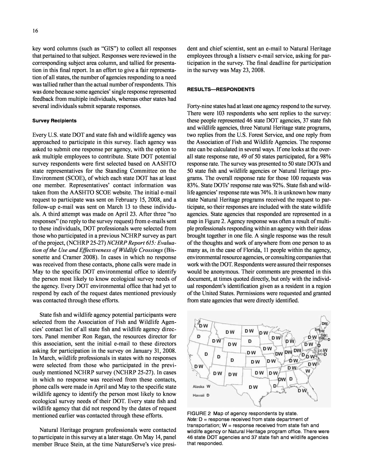
16 key word columns (such as âGISâ) to collect all responses that pertained to that subject. Responses were reviewed in the corresponding subject area column, and tallied for presenta- tion in this final report. In an effort to give a fair representa- tion of all states, the number of agencies responding to a need was tallied rather than the actual number of respondents. This was done because some agenciesâ single response represented feedback from multiple individuals, whereas other states had several individuals submit separate responses. Survey Recipients Every U.S. state DOT and state fish and wildlife agency was approached to participate in this survey. Each agency was asked to submit one response per agency, with the option to ask multiple employees to contribute. State DOT potential survey respondents were first selected based on AASHTO state representatives for the Standing Committee on the Environment (SCOE), of which each state DOT has at least one member. Representativesâ contact information was taken from the AASHTO SCOE website. The initial e-mail request to participate was sent on February 15, 2008, and a follow-up e-mail was sent on March 13 to these individu- als. A third attempt was made on April 23. After three âno responsesâ (no reply to the survey request) from e-mails sent to these individuals, DOT professionals were selected from those who participated in a previous NCHRP survey as part of the project, (NCHRP 25-27) NCHRP Report 615: Evalua- tion of the Use and Effectiveness of Wildlife Crossings (Bis- sonette and Cramer 2008). In cases in which no response was received from these contacts, phone calls were made in May to the specific DOT environmental office to identify the person most likely to know ecological survey needs of the agency. Every DOT environmental office that had yet to respond by each of the request dates mentioned previously was contacted through these efforts. State fish and wildlife agency potential participants were selected from the Association of Fish and Wildlife Agen- ciesâ contact list of all state fish and wildlife agency direc- tors. Panel member Ron Regan, the resources director for this association, sent the initial e-mail to these directors asking for participation in the survey on January 31, 2008. In March, wildlife professionals in states with no responses were selected from those who participated in the previ- ously mentioned NCHRP survey (NCHRP 25-27). In cases in which no response was received from these contacts, phone calls were made in April and May to the specific state wildlife agency to identify the person most likely to know ecological survey needs of their DOT. Every state fish and wildlife agency that did not respond by the dates of request mentioned earlier was contacted through these efforts. Natural Heritage program professionals were contacted to participate in this survey at a later stage. On May 14, panel member Bruce Stein, at the time NatureServeâs vice presi- dent and chief scientist, sent an e-mail to Natural Heritage employees through a listserv e-mail service, asking for par- ticipation in the survey. The final deadline for participation in the survey was May 23, 2008. RESuLTSâRESPONDENTS Forty-nine states had at least one agency respond to the survey. There were 103 respondents who sent replies to the survey: these people represented 46 state DOT agencies, 37 state fish and wildlife agencies, three Natural Heritage state programs, two replies from the U.S. Forest Service, and one reply from the Association of Fish and Wildlife Agencies. The response rate can be calculated in several ways. If one looks at the over- all state response rate, 49 of 50 states participated, for a 98% response rate. The survey was presented to 50 state DOTs and 50 state fish and wildlife agencies or Natural Heritage pro- grams. The overall response rate for those 100 requests was 83%. State DOTsâ response rate was 92%. State fish and wild- life agenciesâ response rate was 74%. It is unknown how many state Natural Heritage programs received the request to par- ticipate, so their responses are included with the state wildlife agencies. State agencies that responded are represented in a map in Figure 2. Agency response was often a result of multi- ple professionals responding within an agency with their ideas brought together in one file. A single response was the result of the thoughts and work of anywhere from one person to as many as, in the case of Florida, 11 people within the agency, environmental resource agencies, or consulting companies that work with the DOT. Respondents were assured their responses would be anonymous. Their comments are presented in this document, at times quoted directly, but only with the individ- ual respondentâs identification given as a resident in a region of the United States. Permissions were requested and granted from state agencies that were directly identified. FIGURE 2 Map of agency respondents by state. Note: D = response received from state department of transportation; W = response received from state fish and wildlife agency or Natural Heritage program office. There were 46 state DOT agencies and 37 state fish and wildlife agencies that responded.
17 RESuLTSâNEEDS AND NEW APPROACHES This section is divided into four subsections according to the transportation planning, development, and operations pro- cess. This organization allows users involved in transpor- tation planning to quickly reference the appropriate phase of planning in which they need specific ecological survey information. These subsections are as follows: Systems Long-Range Planning1. Project Development 2. Construction3. Maintenance and Operations. 4. Within each of these transportation phases, an ecological hierarchy was used. This was organized according to sur- vey needs and new approaches for species, and ecosystems and landscapes. Each was addressed in a standard manner for each phase of transportation planning. This organization allows readers to be able to locate similar ecological levels in all levels of transportation planning. Systems Long-Range Planning The ecological survey approaches during systems long- range planning address broad-scale planning in space (landscape to climate change scale) and time (20 years prior to projects). Planning professionals have a need to under- stand the patterns of plant and animal distributions in the general planning areas, what the natural vegetative com- munities may be, and whether wetlands and other sensitive ecosystems are present. They also need to look at overall ecosystem level effects of the proposed transportation plans, such as fragmentation of habitat, potential pollutants, and climate change. Often the local-level scale of species dis- tribution points can be too fine, and a broader, more predic- tive approach over larger areas is most appropriate. Because long-term planning is conducted years in advance of proj- ects, the understanding is that these environmental surveys are conducted to gain a general understanding of the species and ecosystems in an area, and that over time the dynamic nature of ecosystems may change those components. This is especially true when predicting ecological changes and transportation adaptations to climate change. Ecological surveys for long-range planning are typically those of pre- dictive models, potential habitat analyses, maps of species distribution and landscape linkages, and analyses of poten- tial long-term cumulative impacts to ecosystems. This is the stage at which state-level GIS often are used. In this sec- tion, these needs and new approaches for environmental surveys at the long-range planning stages are presented in two subsections. Species Distribution includes the following: Predicting Wildlife and Plant Distribution through ⢠Maps Predicting Species Distribution through Models⢠Predicting Species Distribution and Biotic and Abiotic ⢠Interactions Transportation Act 2005 Legislation and Early ⢠Planning. Broad-Level Ecosystems and Landscapes Surveys and Analyses include the following: Ecosystems Overall Effects⢠Ecosystems Long-Term and Cumulative Impacts⢠Ecosystems Expanding Temporal and Spatial Scales⢠Ecosystems Climate Change Causes and Effects⢠Landcover Maps and Wildlife and Aquatic Linkages ⢠Overview Landcover Maps and Wildlife and Aquatic Linkages ⢠GIS Analyses Landcover Maps and Wildlife and Aquatic Linkages ⢠Maps and Connectivity Plans Landcover Maps and Wildlife and Aquatic Linkages ⢠Overall Local and Regional Planning. Species Distribution Long-range planning needs for species surveys often require the availability of maps, potential distribution models, and overall planning documents to assist with general wildlife and plant distributions. This level of planning requires an understanding of the distribution of species of concern so that routing decisions can avoid or minimize conflicts with such species and their habitats. Wildlife species of concern can include plants and animals legally protected under federal or state statutes (e.g., threatened or endangered). Additionally, rare or declining species that are not formally protected by law often receive particular attention by resource manage- ment agencies. For example, species regarded by Nature- Serve and its state Natural Heritage program partners as imperiled or vulnerable at a range wide (G1âG3) or state (S1âS3) level frequently are taken into account in both long- range and project planning. Other wildlife species that may be of concern in long-range planning efforts include locally or regionally valued game species, and species with specific management issues related to specific places, such as wading birds or deer herds with specific wintering areas of habitat. Species survey needs often include maps of documented occurrences (especially for rare species), occupied or poten- tial habitats, or general distributions for the species of inter- est. Although many respondents detailed needs for species location information in the context of project-level planning, the long-range planning-level timing of surveys also was
18 vides a summary of which species at risk are known from each state, county, or watershed (NatureServe). All 50 states have Wildlife Action Plans that identify species of greatest conservation need. Many of these plans present some form of maps for these species, their priority habitats, or important conservation areas. Some also pro- vide information on invasive species that could be useful in long-term transportation planning. State Wildlife Action Plans outline the steps that are needed to conserve wildlife and habitat before they become rarer and more costly to pro- tect. Taken as a whole, these plans present a national action agenda for preventing wildlife from becoming endangered. For listings of every state wildlife action plan, see âState Wildlife Action Plansâ in the References. Predicting Species Distribution through Models One area of technological advance in recent years has been the development of the use of computer models to predict areas where suitable habitat for particular species may occur. Because long-range planning usually requires more gener- alized regional information on the distribution of sensitive resources, such predictive models can distinguish among places with potential conflicts and those with no known con- flicts. These models can better target more efficient and cost- effective field survey work for at-risk species and provide an early warning of areas where ecological conflicts may exist for potential transportation projects. A number of predictive species distribution models, which combine known occurrences of species with underlying environmental data layers, are now in use within the scien- tific community. NatureServe, for instance, has developed a GIS-based Predictive Distribution Modeling (PDM) method to produce probability maps of areas where elements such as species and ecological community types are likely (or not) to occur. Advantages of this method include that predictive maps make field inventories more efficient and effective; they also show where to commit limited inventory resources for the highest likelihood of documenting the specific spe- cies or ecosystem component that is the target of the survey. These maps predict multiple ecological elements, including wildlife, plants, natural communities, and water resources, allowing for a more comprehensive holistic approach to eco- logical surveys. Several state Natural Heritage programs are using variants on this PDM method to guide inventory work and identify new populations of rare species and natural communities. They include Oregonâs Natural Heritage Infor- mation Center, New Yorkâs Natural Heritage program, and Wyomingâs Natural Diversity Database (NatureServe Pre- dictive Distribution Modeling). In New York, for instance, the Department of Environmental Conservationâs Natural Heritage program is using a local version of these predictive modeling tools to provide New York State DOT with state- wide predictive distribution maps for priority species for use in its transportation planning and review. identified as an issue. Specifically, respondents indicated a need to better distinguish between areas that potentially may support a species of concern and areas that actually are occu- pied by the species. Survey work to distinguish this often must be planned and carried out well in advance of actual project design work. Nine respondents mentioned the need to better plan surveys with respect to time. The two major themes of these responses were as follows: Guidelines need to be established to prompt timing 1. of surveys to plan years ahead of the actual survey so these surveys can be conducted in a timely manner and the information can get back to planners with enough time to plan a project long enough in advance to pos- sibly avoid or minimize transportation impacts. Planning should occur at longer time scales ahead of 2. projects to better plan for surveys so that they can be conducted for species at the correct time of year. One dilemma associated with the early timing of sur- veys is the expiration of survey data. If the ecological sur- vey is conducted too many years in advance of a project, the resource agencies may require up-to-date surveys. Another quandary is the project funding for surveys may not materi- alize with enough leeway to conduct timely surveys. These needs are partially addressed in the next section on new approaches under timing of surveys. New approaches to help determine wildlife and plant locations for systems long-term transportation planning involve the use of existing maps, aerial photographs, soft- ware and models to analyze these data, and reports and tools developed by natural resource agencies and orga- nizations to assist in early development planning. The previously cited needs focused on how to approximate species locations through distribution maps and models, and appropriate timing of calls for surveys to better docu- ment species presence or absence. These new approaches involve the following: Predicting wildlife and plant distribution through ⢠maps Predicting species distribution through models⢠Predicting species distribution and biotic and abiotic ⢠interactions Following Transportation Act 2005 legislation and ⢠ensuring early planning. Predicting Wildlife and Plant Distribution through Maps Current sources of species survey data that involve maps for use in long-range planning include the following: All states have a Natural Heritage program, which main- tains databases of documented locations for sensitive plant and animal species. The NatureServe Explorer website pro-
19 effects or for potential mitigation banks. This approach embraces greater interagency cooperation to facilitate these considerations and actions. The Florida Fish and Wildlife Conservation Commission recently developed the Wildlife Conservation Planning Tool, an innovation to help the collaborative process in Florida to prioritize wildlife conservation. Planning strategies for suc- cessful large-scale wildlife protection and habitat manage- ment can require coordinating information and resources from many sources. Tracking down the most appropriate materials can become time-consuming, even overwhelming. To expedite this process, the Wildlife Conservation Planning Tool provides an interactive, computer-based manual that includes links to hundreds of conservation resources. These resources guide project planning from evaluating existing natural resource conditions from a regional perspective to developing habitat management plans for specific properties or projects. Links guide users to a broad range of informa- tionâincluding literature and database hyperlinks, guide- lines for multispecies habitat management and initial site assessments, survey protocols for protected wildlife species, conservation opportunities for private landowners, and con- servation design options for transportation and development projects. The manual assists those requesting or reviewing a permit application for a development project for which wild- life may be adversely affected, or for those planning to con- serve an area with wildlife conservation as a priority. The Wildlife Conservation Planning Tool became available in 2009 (Rousso and Hoehn 2009). The Northwest Habitat Institute (NWHI) created the Interactive Biodiversity Information System (IBIS). It is an informational resource to promote current conservation efforts in the U.S. Northwest. IBIS contains the typical infor- mation about fish, wildlife, and habitats, and also analyzes relationships among these species and their habitat. The data have been developed for 5 years, and NWHI may use this information as a base for adoption for other areas as well. Delaware DOT uses a system to rank the value of habitats; this ranking is based primarily on the location of known state and federal threatened and endangered species. The ranking system may be developed to include other ecological values of a given site, such as size and diversity of habitat, connec- tivity to other resources, and indirect costs of fragmentation (including increased road mortality, noise pollution, etc.). Transportation Act 2005 Legislation and Early Plan- ning Respondents reported the need for better long-term timing to include consideration of environmental variables in the long-range planning process. This longer time period approach allows for more thorough ecological consideration of potential projects before plans are drawn, and it gives greater opportunity than project-level consideration does to avoid, minimize, and then mitigate for the transportation The Northwest Habitat Institute developed a habitat assessment method that quantifies habitat value in a consis- tent format. A habitat (HAB) value is calculated for each site based on species, habitat types, and functions for each polygon. This method is used by Oregon, Washington State, and British Columbia (Northwest Habitat Institute). Although aerial photography and satellite imagery are not new technologies, considerable advances have been made in the level of spatial and thematic resolution of these imagery sources. These advancements are improving the ability of these technologies to determine the location and extent of vegetation communities and wildlife habitats. In addition, the emergence of web-based mechanisms to access imagery (e.g., Google Earth, MicroSoft Virtual Earth) is transforming the way in which planners are able to interact with this information. In North Dakota, the DOT intends to begin examining the use of infrared aerial photography to identify plant com- munities with little ground-truthing required. Booth et al. (2006a) describe software packages that take digital aerial images over large scales (Very Large Scale Aerial ImageryâVLSA) and accurately (90% accuracy) predict specific objects such as streams, animals, logs, plant canopies, riparian habitat, and vegetative communities from large-scale images down to images as fine as 1 millimeter per pixel. The authors recommend these software packages to expand the utility of aerial image data. Other methods are developing of using satellite and aer- ial imagery to determine species and community locations. Local offices of the Nature Conservancy and Natural Heri- tage programs are some of the best resources for learning about the methods being developed in their region. Predicting Species Distribution and Biotic and Abiotic Inter- actions Approaches that use multiple layers of data and present them to users to better understand ecological inter- actions across the landscape are presented in this section. These approaches typically are developed by natural resource agencies and organizations that have a deep understanding of biotic and abiotic conditions and interactions as well as an understanding of how these interactions result in the species distributions on the landscape. This more in-depth ecologi- cal approach to species distribution is a development that is typical of how resources will be assessed in the future. Both the transportation communityâs Context Sensitive Solutions and the more recent Eco-Logical planning approach embody this larger context view. This view includes expanding the temporal scale of considering ecological resources in long- term planning undertaken 20 or more years before potential projects and over longer time scales of considering effects and mitigation, measured in decades. It also means that the spatial scale of ecological considerations extends far beyond the road right-of-way to areas not normally considered for
20 scientific manners that allow for greater representation of a larger area, and allow for GIS-based modeling approaches to predict potential occurrences as well as impacts. These approaches highlight a change in the approach from survey- ing a specific area before potential development to looking at the greater landscape over longer time scales in advance of a potential project. This even includes looking for transporta- tion causes of climate change and managing for potential changes from this global phenomenon. For survey needs and new approaches at this long-range planning phase, the large- scale approach is sectioned into (1) ecosystem concerns, and (2) landcover and linkage mapping and analyses in the fol- lowing manner: Ecosystems Overall Effects⢠Ecosystems Long-Term and Cumulative Impacts⢠Ecosystems Expanding Temporal and Spatial Scales⢠Ecosystems Climate Change Causes and Effects⢠Landcover Maps and Wildlife and Aquatic Linkages ⢠Overview Landcover Maps and Wildlife and Aquatic Linkages ⢠GIS Analyses Landcover Maps and Wildlife and Aquatic Linkages ⢠Maps and Connectivity Plans Landcover Maps and Wildlife and Aquatic Linkages ⢠Overall Local and Regional Planning. Ecosystem Overall Effects Ecosystems need to be sur- veyed for large-scale impacts over time, such as cumulative impacts, and over larger areas, such as fragmentation effects. At the same time, predictions need to be made regarding base conditions and how potential transportation activities would affect them. Ecosystems sustain a multitude of effects from transportation corridors that traditionally have not been assessed at the regulatory level, such as cumulative impacts and fragmentation. Today, a greater regulatory emphasis is placed on assessing these impacts than in the past and there is more interest in these findings. A minimum of 13 respon- dents identified the need to survey the impacts of roads on ecosystems and their processes. These include effects not regulated in the past but that are now part of regulatory con- sideration, such as current, future, secondary, and cumula- tive impacts. Fragmentation effects on terrestrial and aquatic ecosystems are also an ecological survey need, according to six survey responses. Respondents also noted a need to survey baseline natural conditions to assess and understand what the desirable conditions would be, and where core areas and corridors are needed to sustain different species, such as neotropical migrant birds, carnivores, and large ungulates, to better prevent fragmentation. The current environmental regulations call for a review of the ecosystem effects resulting from transportation pre- dominantly for construction phases. Some states look at long-term maintenance impacts as part of biological assess- ments undertaken during the environmental review phases in development. In a 2006 survey, Cramer and Bissonette (2007) reported that 28 of 50 state DOTs surveyed reported begin- ning ecological considerations at the project level, and only 14 states reported any consideration of these resources at the long-range planning (20 years) level. The remaining statesâ respondents reported that they began ecological consider- ation at the State Transportation Improvement Plan (STIP) level. Developments in the 2005 transportation bill require early planning for environmental resources. The passage of the 2005 Transportation Act (known as SAFETEA-LU, the acronym for the Safe, Accountable, Flexible, Efficient Trans- portation Equity Act: A Legacy for Users) Section 6001 man- dates that long-range plans be created with the consultation of natural resource agency personnel through the review of resource maps and inventories to identify potential environ- mental conflicts and mitigation activities. It requires states to develop long-range transportation plans with a minimum 20-year outlook and a reasonable opportunity for public comment. Section 6001 of the act requires 20-year plans to include the following: Consultations with resource agencies, such as those ⢠responsible for land-use management, natural resources, environmental protection, conservation, and historic preservation, which shall involve, as appropri- ate, comparisons of resource maps and inventories Discussion of potential environmental mitigation ⢠activities and potential areas to carry out these activi- ties, including activities that may have the greatest potential to restore and maintain the environmental functions affected by the plan Participation plans that identify a process for stake-⢠holder involvement. Section 6002 of SAFETEA-LU establishes a new envi- ronmental review process for highways, transit, and mul- timodal projects. This new process, mandatory for all environmental impact statements (EIS), requires a new pub- lic comment process on the purpose and need of the project. The range of alternatives encourages greater participation from more agencies and organizations, as well as the public (SAFETEA-LU). Broad-Level Ecosystems and Landscapes Surveys and Analyses An overall theme among responses was the need for under- standing what ecological attributes are present at the ecosys- tem and landscape scale before project-level planning begins. At least six respondents explained that without knowledge of the species, landscape linkages, and sensitive ecosystems presence in an area before transportation development, we risk losing these ecological attributes without even knowing they are gone. Surveying at these larger scales is difficult and relies heavily on mapping analyses that seek to extract data from satellite and aerial data, surveying and monitoring in
21 Ecosystems Long-Term and Cumulative Impacts There are regulatory reasons for assessing long-term impacts, includ- ing the Endangered Species Act. To help meet these require- ments and go beyond the scope of the law, there are new approaches to examining the effects and potential effects of transportation on ecosystems and processes. Some of these approaches are presented under GIS tools in the landscape- level sections later in this report. Those approaches that directly address ecosystem-level needs and that were discov- ered in the course of this survey include those that address cumulative impacts or the ecological effects of potential projects. Following are a variety of examples. The Colorado DOT recently (2008) released a cumulative impacts analysis document, âArea Wide Coordinated Cumu- lative Effects Analysis.â The project evaluated whether and how a spatial accounting approach can be used to identify the cumulative impacts on the environment that result from the incremental impacts of multiple transportation and other projects, and related urbanization at a regional scale. Spatial accounting methods were employed to inventory improve- ment or decline in the quality of key resources over multiple time periods, jurisdictions, and projects. The tools of spatial accounting include the following: (1) data typically housed in a GIS; (2) models for the evaluation of environmental effects resulting from transportation projects and programs; and (3) metrics such as indicators or thresholds, which can be used to assess the importance of change in resource quali- ties. This type of analysis is close to what the survey respon- dents voiced was a necessary approach (Muller et al. 2008). The EPA sponsored a study at Colorado State University on approaches to cumulative impacts: Hydrogeomorphic Wetland Profiling: An Approach to Landscape and Cumu- lative Impacts Analysis (Environmental Protection Agency 2005). The study developed a synthetic, hierarchical, and scalable approach to landscape characterization and a cumu- lative impacts analysis of wetlands. The EPA also prepared an online report, Cumulative Impact Assessment: Synoptic Approach to Cumulative Impact Assessment: A Proposed Methodology (Environmen- tal Protection Agency 1992). The report provides resource managers and technical staff with an approach to evaluate the cumulative environmental effects of individual human impacts on the environment, particularly with respect to wetlands. The Integrated Wildlife Habitat Ranking System (IWHRS) is a GIS-based habitat model developed by the Florida Fish and Wildlife Conservation Commission com- posed of 10 statewide data layers that represent impor- tant ecological aspects for wildlife species in Florida. The IWHRS is used to conduct environmental reviews of devel- opment and transportation projects and to perform impact assessments, including direct, indirect, and cumulative accordance with National Environmental Policy Act (NEPA) regulations. Other states are also looking to reduce mainte- nance and operations impacts to ecosystems and species by assigning environmentally trained professionals to main- tenance units, as done by the California DOT (Caltrans). The current systems of studying and estimating ecological impacts typically address short-term effects from transpor- tation activities and traditionally have not addressed the long-term and cumulative effects resulting from increases in traffic volume maintenance activities such as herbicide spraying, the urbanization that occurs with the development of roads, and other changes to the water, air, land, and over- all connectivity of the landscape. The traditional approach could be improved and enhanced by looking at broader spa- tial and temporal effects. Several respondents thought that modeling could be used to assess ecosystem-level impacts. One respondent men- tioned that better models could be developed to identify eco- logically significant areas or to predict impacts and minimize or mitigate for losses. Others throughout the survey men- tioned the need for predictive modeling. Predictive modeling used to identify features that are important in avoidance and mitigation is becoming widespread, and respondents voiced a need for its increased use. A southeastern respondent noted a need to develop more efficient methodologies to locate potential wildlife crossings by comparing existing models of landscape permeability and connectivity, to create a reserve network design, and to identify sightings of wildlife cross- ing. Several respondents mentioned the need to calculate the value of ecosystems to determine the cost-effectiveness of mitigation measures. Such assessments were mentioned eight times in survey responses. Ecosystem assessment was mentioned in the context of evaluating ecosystems for pol- lutants, including gravel, sand, and salt runoff into aquatic systems. A northeast response included the need for a rapid assessment technique to be developed on a watershed or eco- system scale to better factor ecological resources into the planning and design of projects. Based on the results of the ecological survey, many needs for ecosystem-level impacts were identified. The needs expressed in this survey include the following: Conduct a survey for long-term, cumulative impacts ⢠to ecosystems Conduct a survey for indirect impacts, such as ancil-⢠lary urbanization of road areas Conduct a survey for fragmentation effects of road on ⢠environmentally important areas and predictive mod- eling to minimize potential impacts Expand the scope of environmental surveys of ecosys-⢠tems to include long-term and large spatial areas that could be affected Evaluate the potential effects that climate change will ⢠have on transportation systems, and how those systems contribute to this change.
22 Some states such as California are already mandated by their legislatures to plan for climate change in projects and daily operations. Others have greenhouse gas reduction goals (see the Florida example discussed later). Legislated initiatives, as well as studies and technologies, can help with these and other goals of dealing with climate change. The following new approaches are presented as initiatives, stud- ies, and technologies to address climate change at the eco- logical surveys level. Florida is proactive in considering the reduction of greenhouse gases as one of the ways in which the govern- ment should be involved. The governor of Florida issued an executive order that establishes greenhouse gas emission reduction targets from 2017 to 2050. Additional direction is provided to develop rules to achieve the following: (1) reduce the maximum allowable emissions level of greenhouse gases for electric utilities; (2) adopt California motor vehicle emission standards; and (3) adopt a statewide diesel engine idle-reduction standard. Transportation models have been developed to measure the particulates that are considered to degrade the quality of the atmosphere. Although this is not a specific survey method, these standards will lead to quantifi- able methods to evaluate changes from climate change and may lead to new ecological survey standards. Another recent initiative calls for the potential inclusion of global warming impacts in environmental analyses docu- ments. In February 2008, the International Center for Tech- nology Assessment, the Natural Resources Defense Council, and the Sierra Club petitioned the chairman of the Council on Environmental Quality (CEQ), and the executive office of the president, requesting that the CEQ amend its regula- tions to clarify that climate change analyses be included in environmental review documents (see Climate change CEQ for more information). Several respondents from across the United States men- tioned a study funded by the U.S.DOT and U.S. Geological Survey (USGS): âImpacts of Climate Change and Variability on Transportation Systems and Infrastructure: Gulf Coast Study, Phase Iâ (U.S. Department of Transportation and U.S. Geological Survey 2007). This study has dozens of authors. The ultimate goal of this joint U.S.DOTâUSGS research is to provide the knowledge and tools that will enable transporta- tion planners and managers to better understand the risks, adaptation strategies, and trade-offs involved in planning, investment, design, and operational decisions in the face of climate change. A recently released book by the National Research Coun- cil, Potential Impacts of Climate Change on U.S. Transpor- tation (National Research Council Committee on Climate Change 2008), was written by committee. This book con- sists of papers by 12 professionals from state DOTs, universi- impacts to important habitat systems and wildlife resources in the state. The IWHRS is especially useful in performing larger, landscape-level assessments of linear projects, such as highways, and has been incorporated into Floridaâs Effi- cient Transportation Decision Making (ETDM) web-based tool. For a detailed discussion of these tools, see chapter three, Case Study 1. The University of MassachusettsâAmherst is developing a system of GIS analyses for ecosystems called Conservation Assessment and Prioritization System (CAPS). The model will assess connectivity to natural areas, evaluate mitigation efforts, and inform the design of new roads. This is one of the few models that attempt to address the fragmentation impacts from proposed transportation projects (Massachu- setts Conservation Assessment and Prioritization System). For more information, see Massachusetts CAPS below, under Landcover Maps and Wildlife and Aquatic Linkages Maps and Connectivity. Ecosystems Expanding Temporal and Spatial Scales The issue of expanding the scope of transportation ecological surveys beyond the road right-of-way and over longer time scales to better assess transportation effects on ecosystems is being addressed in several national-level initiatives that are being adopted in different areas of the United States. For a detailed discussion of these methods and places they have been and are being used, see chapter three, Case Study 6. DOTs are expanding the environmental scope within their agencies. The environmental considerations are becoming important enough to agencies that some, such as Caltrans and New York State DOT (NYSDOT), have brought envi- ronmentally trained professionals into their maintenance and operations divisions. In this respect, the scope of envi- ronmental concerns has begun to expand across the trans- portation planning, development, and operations process. Ecosystems Climate Change Causes and Effects Climate change causes and effects are so broad in space and time scales that traditional regulatory framework and transporta- tion phases have not addressed them. Increasingly, though, states are taking the lead in finding ways to address these issues within the transportation planning, development, and operations process. Transportation choices, such as improv- ing road lane capacity rather than investing in transit, or affecting intact ecosystems that buffer against carbon diox- ide buildup, directly contribute to climate change. On the other side, climate change effects of longer droughts and more intense storms, sea-level rise, and greater spring run- off pulses affect transportation systems. Twelve participants described survey needs related to climate change. Respon- dents were concerned about the effects of climate change on existing species distributions and terrestrial and aquatic connectivity, the flow of water, loss of habitat and its degra- dation, and the timing of biological functions.
23 Landcover Maps and Wildlife and Aquatic Linkages GIS Analyses GIS data are tremendously important to long- term planning and all other stages of the transportation planning process. The GIS ecological survey needs and new approaches are a major part of this synthesis. It is instructive for readers to understand just how GIS data, also known as geospatial data, are important to transportation planning. In December 2007, the U.S. Forest Service, FHWA, and TRB sponsored the âImproving National Transportation Geospa- tial Information Workshop, New Applications: Environment and Planning.â This workshop examined potential benefits and costs of initiatives to improve the national geospatial information infrastructure for transportation. Organizers Burns, Yanchick, and Perkins penned a white paper that provides an overview of the results (2007). The following paragraph (from that document) crystallizes the need for geospatial data in transportation planning: Geospatial data can assist transportation specialists in understanding the ecological implications of an individual transportation project. They can also be used by planners to understand the broader, more cumulative impacts of a larger regional or statewide transportation system on the natural and human environment. Increased understanding of ecological relationships and the implication of those ecological relationships can improve transportation designs that minimize impacts to the environment, reduce mitigation costs and project delivery delays. As individual environmental elements are influenced ultimately by ecological processes that are regional or even global in nature, data that provide a larger regional or national context may make it easier to understand how different transportation projects or systems can influence those ecological relationships and pathways that may pass through the project planning area. A better understanding of the relationships may make it easier to design projects that minimize or avoid disruptions to these pathways and ultimately minimize environmental impacts. And, since individual transportation projects are often part of a larger system, with implications beyond regional, state, and even national boundaries, this database [of geospatial data] can assist in providing the appropriate context to design more safe and efficient transportation systems appropriate to the needs of transportation users. Beyond increased safety and efficiency, these improved systems can also enhance the human and natural environment (Burns et al. 2007). Survey respondents indicated that the following GIS data needs were important relative to long-range planning: Coordination and cooperation among agencies ⢠Uniform, nationwide survey methods for gathering ⢠and storing remote-sensed data Data-sharing methods that enhance accessibility to ⢠data with relative ease of use Data that are stored in one central location⢠Data that are current and maintained ⢠A one-stop place on the Internet for permitting ⢠processes. The use of GIS is now mainstream among transporta- tion agencies and other land-use planners. Novel uses and ties, the National Oceanic and Atmospheric Administration (NOAA), and consulting companies. Titles of chapters include Understanding Climate Change, Impacts of Climate Change on Transportation, Challenges to Response, Meet- ing the Challenges, and a Summary. Goddard Space Flight Centerâs Global Change Mas- ter Directory (GCMD) website enables users to locate and obtain access to Earth science data sets and services relevant to global change and Earth science research. The GCMD database holds more than 25,000 descriptions of Earth sci- ence data sets and services covering all aspects of Earth and environmental sciences. Users can search using the search box or can select from the available keywords to search for data and services (see Goddard Space Flight Center). In Wisconsin, models are being used to predict the change in stream locations of various fish species associated with increasing water temperatures. The question being addressed is: âWill warm water fish extend their range and cold water fish lose habitat?â The availability of these basic models, and the technology to run them, has provided some interesting scenarios in which to answer that question. Con- tact the Wisconsin Natural Heritage Inventory Program for more information. A growing literature base is dealing with GIS-dependent ecological niche modeling. The potential may exist in this area to improve or develop biological surveys, impacts forecasting, and mitigation in landscapes that are changing because of normal fluctuations, development, and climate change (Dominguez-Dominguez et al. 2006). Light Detection and Ranging (LIDAR) technology could have many applications to assist with measuring environ- mental considerations dealing with climate change. LIDAR is a remote-sensing system used to collect topographic data. This technology is being used by NOAA and National Aero- nautics and Space Administration scientists to document topographic changes along shorelines making it a possible predictor and measuring device for climate change. It can measure distance, speed, rotation, and chemical composi- tion and concentration. It is still being worked on to refine the methods. For instance, Schwartz (2006) reports the LIDAR technology has sometimes read treetops as ground level, skewing the results of the survey data. Landcover Maps and Wildlife and Aquatic Linkages Over- view Landcover maps and wildlife linkage maps and analyses can assist greatly with long-range transportation planning. They provide information on areas where ecosys- tems and species potentially and do occur, data on where landscape and aquatic linkages occur or need to be restored across a state, and information about what lands and water- ways are important for conservation to local and regional citizen and agency efforts.
24 In New Jersey, the New Jersey Department of Environ- mental Protection (NJDEP) GIS information and Landscape Project data are used as preliminary screening tools. The GIS layers encompass many different areas of interest, including threatened and endangered species habitat, wetlands, streams, water quality classifications, and so on. If it is warranted for a project, the NJ DOT uses NJDEP wetlands mapping and the Landscape Project data in preliminary screening to conduct a formal wetland delineation (New Jersey GIS). In Tennessee, the Tennessee DOT is developing the Statewide Early Management System, which will encom- pass the Early Environmental Screening (EES) tool. The EES uses existing GIS data to make better planning deci- sions early in a projectâs life. Experts in various disciplines (e.g., ecology, history, and geology) were brought together to examine available data in their respective disciplines and to decide how those data should be used and displayed to best aid those decision makers. Based on these data, a scor- ing system has been developed that alerts stakeholders of potential roadblocks the project may face along the way. This enables stakeholders to avoid those roadblocks or to build extra time into the schedule to deal with the prob- lems. Planners now have data that are accessible and easy to use but that still contain enough information to make effective decisions. Florida is known for its ETDM web-based tool for han- dling GIS data and long-range and project-level planning. The Florida Department of Environmental Protection and the Florida Fish and Wildlife Conservation Commission have major data development programs and partnerships to enhance accessibility to environmental and ecological GIS data (such as threatened and endangered species, habitat mapping, land-use and landcover classifications, watersheds, wetlands, imagery), improve data-sharing capabilities, and promote interactive and effective interagency coordination (Florida Environmental Resource Analysis Tool). For more information, see chapter three, Case Study 1. Michigan DNR is developing a lake and stream classi- fication system with local-scale and catchment-scale char- acteristics. This system will assist transportation planning because it can identify areas with a large number of unsam- pled locations. In Wisconsin, the DNR has a web-mapping function, The Surface Water Data Viewer. This tool gives special coverage to a variety of water resources. This tool collects information and makes it available for both developers and highway builders. Its mapping application provides water resources, monitoring, and water quality assessment data. Users can view and analyze watershed-related data for lakes and streams, monitoring stations, impaired waters, and Out- standing/Exceptional Resource Waters (see Wisconsin Sur- face Water Data Viewer). applications of GIS continue to appear, and many of these new approaches focus on improving the access, integration, and visualization of various types of spatial data of relevance to biol- ogists and transportation planners. Dozens of GIS approaches and websites could be considered as new approaches to the GIS needs required at the long-term planning scale. These systems typically show promise for more than one of the ecological survey needs addressed previously. For instance, the Florida example addresses the need for coordination and cooperation, while at the same time demonstrates the benefits of having a standardized system in one central place. A general classifica- tion of the GIS approaches in this report is somewhat arbitrary, but it is provided to enable readers to better organize how these approaches can assist in terms of ecological surveys. Each one of these approaches addresses several of the previously cited needs for GIS ecological survey data. Readers are encouraged to explore these programs and websites to determine which solution best represents their specific ecological survey needs. The three types of GIS approaches presented are as follows: (1) coordination and cooperation among agency partners in specific states, (2) general GIS sites with environmental data and methods of data integrations, and (3) standardized and uniform data collection. Coordination and cooperation among agency partners dealing with GIS-based data occur at multiple levels of gov- ernment in every state. GIS systems are now used by every state DOT as well as other agencies. Although the more advanced state GIS systems are better known from their coverage in reports, conference presentations, and FHWA awards (see discussion of Floridaâs ETDM Process in chap- ter three, Case Study 1), other advances are being made by states that are progressing along the continuum of GIS tech- nologies. The following seven examples illustrate some of the different ways that states are bringing GIS data together for planning purposes. Although some readers may not view these examples as âcutting edge,â they nonetheless provide an idea of what different states are doing with GIS to assist with environmental surveys in long-range planning. In Maryland, the State Highway Administration (SHA) is continually building a working partnership with the state resource agencies, which has helped in the sharing of eco- logical survey databases. Their working GIS database is the Green Infrastructure, developed by Marylandâs Department of Natural Resources (DNR) (see Maryland Green Infra- structure Development discussed in chapter three, Case Study 2, and References). Michigan Department of Information Technologyâs Cen- ter for Geographic Information manages the Michigan Geo- graphic Data Library. It is the stateâs repository for GIS and includes more than 60 unique statewide data sets, including the Michigan base map (Michigan Geographic Framework), aerial imagery, geology, hydrology, land ownership, topogra- phy, and other maps (Michigan Geographic Data Library).
25 Also in Wisconsin is the Aquatic and Terrestrial Resources Inventory (ATRI), which provides a central loca- tion from which general data can be retrieved. This informa- tion is available for planning agencies and also includes a strong citizen-monitoring program of a variety of resources (see Wisconsin ATRI). General GIS websites that assist with environmental data and methods of data integration possess information and offer approaches that can help with some of the ecological survey needs listed for long-range planning. FHWAâs website on Planning and Environment Linkages contains information developed and compiled by the FHWA and its partners to assist in strengthening planning and envi- ronment linkages. It represents an approach to transportation decision making that considers environmental, community, and economic goals early in the planning stages and carries them through project development, design, and construction. This approach can lead to a more seamless decision-making process that minimizes duplication of effort, promotes envi- ronmental stewardship, and reduces delays in project imple- mentation (see Federal Highway Administration, Planning and Environment Linkages in References). The USGS maintains a landcover data portal containing federal lands, data from the Amphibian Research and Moni- toring Initiative, landcover, Gap Analysis Program (GAP) analysis resources, water resources such as aquifers, rivers, topographic maps, and many more data layers and links (see U.S. Geological Survey Landcover in References). The U.S. Fish and Wildlife Service maintains a GIS Wet- lands Geo-database (see U.S. Fish and Wildlife Service, GIS in References). The U.S. Department of Agriculture (USDA), Natural Resources Conservation Service maintains a soil-mapping GIS service online, linked with the Soil Survey (see U.S. Department of Agriculture in References). Approximately six respondents mentioned the need to have national or statewide standards for data collection and storage of GIS data. The following software companies, organizations, and initiatives seek to standardize GIS data on natural resources. These efforts have assisted transportation planning across the country and potentially allow greater ease of interagency data exchange across the United States. NatureServe, a nonprofit research organization, sets national standards for the collection and management of data on species and ecosystems used by the network of state Nat- ural Heritage programs. As a result, Natural Heritage data are nationally consistent and can be used in regional and national-scale analyses. NatureServe has developed a U.S. National Vegetation Classification system, which has been adopted by the Federal Geographic Data Committee as an interagency standard for use in classifying and mapping veg- etation communities. NatureServe has developed a midscale ecological systems classification that is serving as the basis for national-scale landcover mapping efforts of the USGS Gap Analysis Program and the USDA Forest Serviceâled LandFire initiative. NatureServe provides access to many of these nationwide species and ecosystem data through its NatureServe Explorer website (see NatureServe Vista). Also see chapter three, Case Study 3. ESRI (Environmental Systems Research Institute) is a world leader in the development of GIS software and provides access to numerous standardized underlying geographic data sets. This company produces ArcGIS, the industry-standard GIS software program used around the globe. ESRI develops specific software applications for individual organizations and states. For instance, Utahâs Geographic Transportation Environmental Assessment System (GTEAS) for analyzing data layers of species of concern was developed specifically by ESRI. Recently, the Western Governorsâ Association, a political organization of 19 western states, was advised by both ESRI and NatureServe on how to map wildlife corridors across the entire western United States. Both organizations develop software for individual states [ESRI (Environmen- tal Systems Management)]. The National Geospatial Program was developed by USGS. This program developed the National Atlas, which contains topographic maps and stream coverages. The National Geospatial Program provides leadership for USGS geospatial coordination, production, and service activities. The program engages partners to develop standards and produce consistent and accurate data through its Geospatial Liaison Network (see U.S. Geological Survey Geospatial Liaison Network in References). The National Map, developed by the USGS, is an online interactive map service based on a consistent framework. It provides public access to high-quality, geospatial data and information from multiple partners (a consortium of federal, state, and local partners who provide geospatial data) to sup- port decision making by resource managers and the public (see U.S. Geological Survey, National Map in References). The Western Governorsâ Association Wildlife Corridor Initiative involved a science committee that made recom- mendations for GIS data collection and storage for 19 west- ern states (see Western Governorsâ Association, Wildlife Corridors Initiative in References). Also see chapter three, Case Study 4. Landcover Maps and Wildlife and Aquatic Linkages Maps and Connectivity Plans Landscape-scale ecological con- nectivity and plans are critical to long-range transporta- tion plans. Long-range transportation planning efforts
26 maps show where wildlife needs to move on public lands and on private land as well. Each stateâs maps have their limita- tions, but the critical attribute of each is that they are tailored to each stateâs needs. The states with greater human devel- opment have limited natural landscape linkages. A recent trend has been to combine several state analyses to identify areas where wildlife movement lands can be linked with other states. The Western Governorsâ Association Corridors Initiative is the most far-reaching example. Several different approaches give a view of the various maps available. In Arizona, a GIS initiative called Areas of Conserva- tion Priority is being developed to identify major areas of importance to wildlife, development threats, and connectiv- ity. The program should engage transportation professionals and developers in maintaining some of the important areas that are identified (see Arizona Natural Infrastructure Data Sources in the References). Since its release in 2006, Arizonaâs Wildlife Linkages Assessment has proven to be a valuable tool in alerting plan- ners to potential conflicts with wildlife movement corridors. Although no formal adoption of the document has occurred, Arizona DOT (ADOT) has put wildlife linkages in their project checklist. ADOT has said that open preservation and wildlife linkages are one of the overarching principles to be considered in framework studies. The Wildlife Link- ages Assessment was a collaborative effort between nine agencies and nonprofit groups to proactively address wild- life connectivity in Arizona. In conjunction with this effort, the Arizona Game and Fish Department funded site-specific Linkage Designs for eight of the identified linkages. The work was conducted by Northern Arizona University (NAU) and led by Dr. Paul Beier. These plans identify and map mul- tispecies corridors that will best maintain wildlife move- ment between wildland blocks, as well as highlight specific planning and road mitigation measures required to maintain connectivity in these corridors. Through this process, NAU developed a GIS extension tool to aid in wildlife corridor planning. The downside of this project is that it works only with ArcView 9.1 or 9.2, a more recent GIS software that not all agencies may possess as a result of budgetary constraints. The completed Linkage Designs are extremely useful when completed before design of a transportation corridor (see Arizona Wildlife entries in the References). Vermont Wildlife Linkage Habitat Analysis is a GIS database of core wildlife movement areas associated with state highways (Austin et al. 2006). For more information, see chapter three, Case Study 2. The University of MassachusettsâAmherst and its part- ners in Massachusetts will build on the existing CAPS through a statewide landscape connectivity study. CAPS is a computer model developed by the University of Mas- sachusetts that incorporates biophysical and anthropogenic need input on areas where landscape and aquatic linkages occur or that need to be restored across a state as well as which lands and waterways are important for conservation to local and regional citizen and agency efforts. Incorporat- ing information from coarse-scale large area maps of areas where wildlife and aquatic species need to move helps plan- ners determine whether potential long-range projects should avoid those affected areas, minimize potential impacts, or include mitigation efforts long before the project-level plan- ning. The Context Sensitive Solutions approach enables transportation agencies to consider the ecological, histori- cal, and human community values and attributes of an area under transportation development consideration. To best consider the ecological resources and the ecological attri- butes that local communities find important, ecological resources must be considered from the data perspective and community conservation priorities perspective. In this sec- tion, needs and new approaches are presented for terrestrial connectivity, aquatic connectivity, and overall planning for local and regional scales. Twenty states expressed the need to identify landscape linkages or wildlife corridors largely for mammals, to avoid, minimize, or mitigate transportation corridors. These responses came from every region of the country. Respon- dents conveyed the sense that data are available for the indi- vidual animals studied, but they are not sufficient to map corridors for the majority of wildlife movement. As one respondent wrote, âGIS mapping that depicts important fish and wildlife habitat and wildlife crossings areas will assist in proactive planning to avoid impacts to valuable habitat, minimize vehicle/wildlife conflicts, and identify potential mitigation opportunities. This will support the requirements of Section 6001 of SAFETEA-LU.â Although these maps are important, it is the data that create them that are lack- ing. Ecological surveys help planners understand different speciesâ movements, which in turn can be combined across studies to create landscape-level maps. Although current maps are helpful, they are often based on consensus among biologists and created through GIS modeling efforts with usually only data for up to five speciesâ needs and distri- bution. Data needs for terrestrial wildlife connectivity thus involve not only maps of potential landscape linkages, but also studies of multiple species to learn how animals use the landscape, especially with respect to roads. New approaches include approximately 20 individual state analyses of terrestrial connectivity for wildlife or green infrastructure mapping. A general overview of these maps can be found under Wildlife and RoadsâLandscape Link- ages in the References. These analyses are developed using two methods: (1) consensus-building rapid assessments through a statewide meeting of concerned professionals, and (2) a GIS-modeling exercise developed specifically for a state that incorporates multiple GIS layers and models of the needs of approximately five keystone species. The resulting
27 rable to what is found naturally. This is especially important in maintaining habitat connectivity for aquatic organisms, such as fish and mussels. Although long-range planning typically does not analyze specific infrastructure such as existing bridges and culverts, a general overview of a poten- tial transportation project must determine whether the exist- ing infrastructure is impeding the movement of water and aquatic organisms and needs to be redesigned or retrofit. In Washington State, this is mandated by state legislation. Ret- rofitting and realigning existing road infrastructure in long- term planning creates an ecological survey need to check existing databases and priority lists of blocked passages to determine what the aquatic connectivity retrofitting will entail. Long-term planning also entails evaluation of exist- ing natural aquatic resources in a general area (1) to evalu- ate how potential transportation project would affect these areasâ connections and (2) to avoid these areas or evaluate how bridge and culvert structures can be designed to reduce hydrologic impacts to aquatic species. Whereas wetlands in general are evaluated for other potential impacts, this part of the long-term planning addresses an ecological survey need to better understand the aquatic connectivity of a system. At this stage in the planning process, potential structures along a transportation corridor may need to be evaluated. As one respondent wrote, âStructure design should be analyzed by an inter-disciplinary team of professionals consisting of a biologist, hydrologist, and engineer to minimize risk of adverse impacts to all aquatic resource values.â This eco- logical survey need also includes the identification of poten- tial pathways for the possible spread of contaminants from a project area, and the spread of invasive species across an area by means of the waterways. The ecological survey needs for aquatic connectivity include the following: (1) maps of exist- ing wetlands and hydrologic data, (2) priority lists and maps of blocked aquatic passage, and (3) a standardized methodol- ogy for determining what constitutes a blocked passage and how to prioritize these areas. The new approaches to understanding aquatic connec- tivity include new classification systems of waterways, web-based mapping functions to better investigate aquatic resources, and fish passage programs that are well organized and allow efficient access to large databases of prioritized passages, as well as standardized methods for collecting blocked passage data. Washington State DOT (WSDOT) recognized that many existing highway culverts are barriers to fish passage. WSDOT has managed a cooperative program since 1991 to inventory, prioritize, and correct these fish passage barriers on the state highway system statewide. Through an assess- ment process, WSDOT has identified and prioritized fish barriers for correction. Fish barriers are corrected as part of transportation improvement projects and also as part of separate stand-alone projects. Since 1991, more than 200 fish barriers have been corrected with project cost ranging data to develop an index of ecological integrity. This Land- scape Connectivity Study will create a spatially explicit tool, including maps and scenario-testing software, to miti- gate the impacts of roads on the environment and inform the design of new roads. This study will assess connections among natural areas and wildlife habitats; design strategies to protect existing connections among habitats (including rivers, wetlands, and forests); locate prime wildlife habitat and movement corridors, where the strategic use of mitiga- tion techniques can be used to facilitate wildlife passage and reduce the risk of animalâvehicle collisions (a-v-c); and examine habitat connections that transcend political bound- aries through regional analysis. This study has been used to site a new highway alignment in Connecticut (see Mas- sachusetts Conservation Assessment and Prioritization Sys- tem in the References). The Maryland Green Infrastructure Project is a GIS mapping tool used to identify and prioritize the stateâs most important natural lands. For more information, see chapter three, Case Study 2. In New Hampshire, the FHWA awarded a grant in 2008 to the Audubon Society of New Hampshire to develop a frame- work to identify transportation and wildlife conflict areas and potential mitigation strategies on an ecosystem scale that can be used before the design phase of state transportation projects begins (see New Hampshire Audubon Society). In Arizona, GIS tools to identify wildlife connectivity on the landscape are available to multiple users, including the Least Cost Path Analyses Corridor Designer Toolbox developed by Beier of Northern Arizona University (see Arizonaâs Wildlife Corridor Planning GIS extension), and the newer Circuit Theory Model developed by McRae of Northern Arizona University (see Arizonaâs Circuit Theory Model). Agency expertise to use these programs in both state wildlife and DOT agencies are necessary to determine and prioritize wildlife corridors. The Western Governorsâ Association adopted the Wild- life Corridors Initiative in 2008. An important component of this initiative is the standardization of data and its storage. A science committee that advised this initiative created a stan- dards manual for future data collection and GIS systems for 19 states to be able to share data and create seamless maps. This is discussed in detail in chapter three, Case Study 5. Aquatic systems connectivity is an important environ- mental concern for long-range and project-level planning. Several respondents replied how the hydrologic connectiv- ity of rivers, streams, estuaries, marshes, bogs, and other wetlands and uplands is an important information need in long-range planning. For these systems to function, the water quality, quantity, exchange, and organism movement all need to be maintained or restored in ways that are compa-
28 working environment (see Integration of Conservation, Highway Planning and Environmental Permitting Using an Outcome-Based Ecosystem Approach in References). For a detailed description, see chapter three, Case Study 6. The FHWA helped sponsor the âLinking Conservation and Transportation Planning Workshops 2006.â These work- shops were held to improve linkages between conservation and transportation planning, with an emphasis on long-range planning. Hosted by the FHWA Project Development and Environmental Review Office, NatureServe, and Defend- ers of Wildlife, the workshops emphasized the use of infor- mation, tools, and methods that can be shared between the transportation community, and the resource and regulatory agencies at the local, state, regional, and national levels. The workshops focused on using tools and information devel- oped by NatureServe and its state Natural Heritage program members, as well as linking transportation planning to other conservation approaches, including State Wildlife Action Plans. The workshops demonstrated how the information and tools presented can save money and time by streamlin- ing transportation projects and planning (see âLinking Con- servation and Transportation Planning Workshopsâ 2006). The Oregon Bridge Delivery Partners website showcases the new way that the Oregon DOT is replacing aging bridges by bundling several projects into a single set of environ- mental analyses (see âOregon Bridge Delivery Partnersâ in References). This approach is conducted at the long-term planning scale to provide an overview of which bridges are priorities for replacement and which can be bundled. Engineersâ drawings were mentioned by one survey respondent as a means to connect people who are working on long-term plans. The respondent wrote, The transfer of information between transportation planners and biologists could be facilitated by providing engineering drawings referenced to landscape features. Where possible, drawings should include plan view perspectives on more biologically meaningful base such as a topographic map, ortho-photograph, or remote sensing imagery. This will allow for more meaningful and efficient biological reviews for potential impacts, as engineering line drawings and station numbers are time- consuming to cross-reference This idea of connecting engineer drawings with topo- graphic maps, ortho-photography, and remote-sensed images could bring to life transportation plans and be a means to unite different professionals and talk about potential plans. At the same time, the interested parties will be able to visu- alize the features that other participants may have assumed were understood. Following are other tools and software that can assist with planning for ecological components of ecosystems affected by long-range planning. from less than $100,000 for retrofitting existing culverts to several million dollars for replacing barrier culverts with bridges under major interstates. Access to about 500 miles of stream habitat has been improved through this effort. A fish passage website helps users scope fish passage barriers in the predicted area of future projects. Links to references are available on the process of installing and monitoring fish passages (for links, see Washington State Department of Transportation Fish Passage Program). Caltrans has standardized methods for identifying blocked fish passages and how to design culverts for aquatic passage (see California Fish Passage). In Massachusetts, Scott Jackson of the University of Mas- sachusettsâAmherst has developed a system to help identify blocked fish passages and to install aquatic passages (Jack- son 2004). Additional information on fish crossings is presented under project-level considerations, Landscape Connectivityâ Streams and Fish Connectivity . Landcover Maps and Wildlife and Aquatic Linkages Overall Local and Regional Planning Conservation plans for local and regional scales can help inform the planning process to identify what the ecological resources and plans are at local and regional scales. Although the state transportation agency creates the long-range plans and brings them into a statewide long-term program, these plans are based on the direction that local Metropolitan Planning Organizations and Rural Transportation Planning organizations and com- munities have indicated they would like to follow in trans- portation and development. According to the Topic Panel for this project, the incorporation of local and regional plans was an important data need for ecological surveys. The new approach to incorporate local and regional plans into broader-scale plans includes connecting stakeholders, prioritizing approaches to development and conservation, and entering these approaches into a computer model to pre- dict outcomes. Following are the more highly used methods that have assisted with transportation planning. The Eco-Logical guide to planning expands the scope of transportation planning to bring in landscape-scale and long-term time frames. It outlines a process of collaborative decision making (see Eco-Logical Performance Measures in the References). The next phase of implementing Eco-Logical will be based on the research results of two SHRP 2 projects. For more information, see chapter three, Case Study 6. SHRP 2 Research Projects C06(A) and C06(B) are under way at the time of this writing. The anticipated results will help with long-term large-scale planning and future assur- ances that create a larger-scale assessment, mitigation, and
29 existing parks and protected areas, and a variety of ancillary environmental information (NatureServe Landscope Amer- ica). For more information, see chapter three, Case Study 5. The Natural Capital Project, a collaboration among the Woods Hole Institute for the Environment at Stanford, The Nature Conservancy, and World Wildlife Fund, maintains a website called InVEST (Integrated Valuation of Ecosystem Services and Tradeoffs). This tool places realistic values on ecosystems in todayâs markets. InVEST can model and map the delivery, distribution, and economic value of life support systems contributed by ecosystems into the future. The tool enables users to visualize the impacts of potential decisions, and identify trade-offs and commonalities among environmental, economic, and social systems (see Natural Capital Projectâs Integrated Valuation of Ecosystem Service and Tradeoffs). Metro Quest software provides an approach for urban and regional planning that allows stakeholders to vote on what they would value in future scenarios. In early planning, par- ticipants in workshops can choose to incorporate ecological and build-out choices to determine what the area of interest would look like in the future. The program was developed in British Columbia, and a number of Canadian cities have used it in long-term planning (see Metro Quest). The North Central Texas Council of Governments has created a website for Planning and Environment Linkages (see North Central Texas Council of Governments in the References). This site integrates environmental and natural resource conservation planning and transportation planning to enhance environmental considerations during the trans- portation planning process. The site is designed to provide information, gather feedback, and establish a forum for communication and collaboration to enhance the consid- eration of environmental impacts during the transportation planning process. The Trust for Public Land (TPL) uses computer models created with GIS software to analyze community-based data. Their GreenPrinting service helps communities make informed decisions about land conservation. The service encourages partners to work toward common goals. The models combine layers of spatial information to guide growth management efforts, including the following: com- munity-defined conservation priorities; mapping waterways in an effort to determine key lands critical to protect water quality; lands necessary to defragment the landscape of con- servation lands; and land development forecasting (see Trust for Public Lands, GreenPrinting Service). The following studies are available concerning ways that states can use broad-scale local approaches to address eco- logical resources during the long-range planning scale. Comparative Risk Assessment Framework and Tools (CRAFT) software was designed to assist in the planning and evaluating of management alternatives. It provides a structured approach to identifying objectives, developing and comparing alternative actions, and displaying the trade-offs and risks associated with different decisions. CRAFT uses a decision framework developed in the management sciences to compare decisions made under uncertainty. CRAFT is designed primarily for use in a facilitated team environment. Individuals can use CRAFT, but a planning team is more likely to have access to the range of resources and perspec- tives necessary to conduct an integrated risk assessment (see Comparative Risk Assessment Framework and Tools). Community Viz is a software program that works as an extension to ArcGIS, a well-used GIS program. The soft- ware is designed for land-use planning and to help people visualize, analyze, and communicate about important land- use decisions. It can be used to site roads, predict future traf- fic volumes, and estimate environmental impacts. NatureServe Vista is another software program that is an extension to ArcGIS. This decision-support system is designed to explicitly incorporate biodiversity into land- use planning processes and can be used in transportation planning. NatureServe Vista enables the user to identify the suite of resources of interest or concern (e.g., species, habitats, or other features) and to create scenarios that look at the potential effect of alternative alignments or plans on those features. The Ecosystem-Based Management (EBM) approach considers the entire ecosystem (with humans) rather than managing one issue or resource in isolation. This is in accor- dance with a move among many federal natural resource agencies to consider more than species and look at entire ecosystems. In New York (through an executive order) and California, EBM is factored into decisions dealing with trans- portation. The EBM Tools Network maintains a website that connects developers and users of software tools focused on EBM. The EBM Tools Network is focused mostly on coastal and marine systems, but increasingly it is incorporating tools that have application to EBM for terrestrial and aquatic systems. The website provides access to a broad spectrum of software tools and analytical methods in this rapidly grow- ing field (see Ecosystem-Based Management Tools Network in References). Landscope America is a new web-based initiative of NatureServe and the National Geographic Society that is designed to provide easy access to conservation priorities that have been set by numerous agencies and organizations. Through the use of an Internet-based map viewer, the site provides users with the ability to zoom from national to state and local levels, and to view open-space protection priorities,
30 Landscape ConnectivityâStreams and Fish Connecti-⢠vity Overall Planning for Local and Regional Scales. ⢠Species Presence, Distribution, and Health The project development phase is when there are the highest level of needs for understanding species presence, distribu- tion in specific places, population numbers, and the overall health of present populations. Survey respondents described survey needs for species at the project level more than at any other time during the transportation planning, project development, and operations process. This section of the report is where the majority of needs and new approaches are presented for species surveys in detail. Of particular con- cern during project development is the presence of any spe- cies that may have formal protections under federal or state endangered species acts, although many state DOTs are now working to identify and understand the needs of, and poten- tial impacts on, a much broader array of species of concern. Presence and Distribution Because of the nature of the project development process, more detailed and finer grained information on the location of species of concern is required than at the long-range planning level. In particular, there is a need to go beyond general distributional information, and have survey information available that is capable of distin- guishing among potential habitat and occupied habitat for species of concern. In general, biological professionals are much better at verifying the presence rather than the absence of a species. Indeed, many of the survey needs identified have to do with improving the chances of detecting target species when they are present, and thereby improving understand- ing of presence and absence. Although only five agencies responded there was a need for presence-absence informa- tion on plant or animal species at the project levelâall 50 state agencies need these data. The species survey needs respondents detailed involved sensitive species in general, aquatic species, reptiles and amphibians, listed species of cactus and other plants, presence-absence data on common species, and distribution and abundance for species of con- cern. Topic Panel members for this synthesis conveyed a strong need for agencies to have additional tools to address these presence-absence surveys of plants and wildlife. State Natural Heritage programs are the major source for detailed locational (GIS-based) data on the presence of spe- cies of concern. They maintain georeferenced databases of the documented occurrences for most rare and endangered species. Consisting of documented occurrences, Natural Heritage databases explicitly strive to minimize errors of commission (indicating that a species exists where it does not), which is essential for use in regulatory processes. In so doing, however, they are subject to errors of omission (that is, they do not necessarily indicate all possible places a species In Montana, the Eco-Logical approach was applied by an interagency group looking to conduct long-term planning and mitigation along US-93. Hardy (2007) documented how this approach worked. The state has taken lessons learned along this highway and started the next set of steps in proj- ects along MT 83 to the east of US-93. A potential problem that the Eco-Logical approach has encountered in planning for MT 83 is that the process needs to be conducted some- where between the time a potential project is nominated and when it becomes an approved project, which occurs between long-range planning and placement in the State Transporta- tion Improvement Program. The MT 83 process began with projects that were being planned, but that were then pushed to future dates. These dates are so distant that the planning process becomes uncertain at best (see Hardy 2007). For more information, see chapter three, Case Study 6. FHWA and NYSDOT are sponsoring an Eco-Logical grant in New York to provide an Eco-Logical perspective to transportation planning efforts and empower other agency partners to support the process. The research will result in the development of two draft Regional Ecosystem Frame- works (New York Study: Long-Range Planning). Project Development For purposes of the organization of the report, the project development stage includes corridor planning, State Trans- portation Improvement Projects, and project planning, design, and development. During the project planning and design phases, ecological survey needs in large part are iden- tified by the regulatory requirements of the NEPA, which are initiated at this stage. Regardless of the regulatory reasons, project development initiates needs for ecological surveys that evaluate a specific area for potential occurrences and effects to species, ecosystems, and landscapes. As with the previous and following sections, project development survey needs and new approaches are presented in the species and ecosystems and landscapes formats. The survey needs and new approaches at this phase have in part been covered in the long-range section and in later sections of the report. Most of the focus of this phase in this report is the survey needs and new approaches for species. The section is organized in the following manner. Species Presence, Distribution, and Health Presence and Distribution ⢠Population Abundance and Health. ⢠Ecosystems and Landscapes EcosystemsâWetlands and Sensitive Communities⢠EcosystemsâNoise and Pollution⢠Landscape ConnectivityâWildlife Crossings and ⢠AnimalâVehicle Collisions
31 recreational and professional bird watchers who document the presence or absence of species, as well as bird abundance through checklist data. eBird provides data sources for basic information on bird abundance and distribution at a variety of spatial and temporal scales. In 2006, participants reported more than 4.3 million bird observations across North Amer- ica, making this database a âmust seeâ for those needing to survey bird resources for transportation planning. A simple web-interface engages participants to submit their observa- tions or view results by means of interactive queries into the eBird database. A survey respondent mentioned how helpful this information has been and the potential value that these data may have at small scales in relationship to project devel- opment and resource evaluations (eBird in the References). An alternative to comprehensive surveying for species is an approach that Wisconsin has embraced, according to one respondent, by assuming the species is present. A Wisconsin respondent replied that their DOT (WisDOT) does a reason- ably good job of providing for surveys of species to deter- mine presence and abundance. If surveys are not completed, the assumption is âthe species of concern is presentâ and WisDOT avoids and minimizes impacts accordingly. In Michigan, the Endangered Species Assessment is a new website to help agencies avoid adverse impacts to known eco- logical resources. The site gives a preliminary assessment of resources (Endangered Species AssessmentâMichigan). Predictive Modeling is one area of technological advance in recent years that has been developed to predict distribu- tion of rare species. These models can be an aid in better targeting field survey work for at-risk species. The model- ing can also help to identify areas that could be avoided by transportation projects. As described in the section Systems Long-Range Planning, NatureServe together with a num- ber of its state Natural Heritage program partners, has been involved in putting these modeling methods to use in creat- ing predictive maps for species of concern. Population Abundance and Health Once a species has been detected or is assumed to be in an area (presence-absence), there are survey needs to understand how it is distributed and how large its population is. There are also needs to estimate the potential impacts of transportation systems on those spe- cies. Two general approaches to this need for species distribu- tion and population sizes are to map habitats of those species and consider those areas as the places where the wildlife and plants are, or are potentially, and the other is to survey for the specific species with different technologies. Habitat or ecosystem mapping is a method that would typically be considered an ecosystem level of environmental surveys. This approach is typically conducted to help determine the distribution of the species within the mapped habitat, thus is presented as an ecological survey need for species. Five responses to the e-mail survey mentioned the need to have may exist). As a result, a number of new approaches focus on using models to predict where, other than at documented localities, species of concern or their habitats exist. Other new approaches and innovations have to do with improved abilities to access and search species distributional data to determine whether potential conflicts with transportation projects may exist. New approaches include the following: A number of Natural Heritage programs have begun con- verting their precise locational data on rare species and natu- ral communities into mapping units that indicate not only the location of the species of concern, but also the surrounding lands and waters that are essential for the survival of the spe- cies at that location. The Massachusetts Natural Heritage pro- gram has carried this out for the entire state and produced a âBioMapâ that is now being used by all levels of government in the state for avoiding impact to sensitive ecological areas. Virginia DOT is supporting the Virginia Natural Heritage program in the development of a similar data layer identify- ing sites of importance for sensitive species. The New York Natural Heritage program is also defining âimportant areasâ based on their potential to support rare species. Florida Natural Areas Inventory (FNAI, Floridaâs Natu- ral Heritage program) created another tool visualizing where rare species in the state are found. The Rare Species Site: The Biodiversity Matrix Map Server (see FNAIâRare Spe- cies Site in the References) is a new screening tool from FNAI that provides immediate, free access to rare species occurrence information statewide. This tool allows the user to zoom into the site of interest and create a report listing documented, likely, and potential occurrences of rare spe- cies and natural communities. A reference to help practitioners and researchers alike is Occupancy Estimation Modeling: Inferring Patterns and Dynamics of Species Occurrence (MacKenzie et al. 2006). This book examines the latest methods in analyzing pres- ence-absence data surveys. The authors use four classes of models: single-species, single-season; single-species, mul- tiple seasons; multiple-species single season; and multiple- species, multiple seasons. Donovan and Hines (2007) have developed exercises on the Internet to help develop methods described in MacKen- zie et al. (2006). Donovan has also worked with researchers who use scat (feces) detection dogs to help determine forest carnivore species of wildlife. [For more information on these techniques see Long et al. (2007, 2008).] Presence or absence information can also be obtained through initiatives that involve citizen monitoring. A program called eBird was launched in 2002 by the Cornell Laboratory of Ornithology and National Audubon Society. The goal of this program is to maximize the utility and accessibility of the large numbers of bird observations made each year by
32 The Association of Fish and Wildlife Agencies is develop- ing a monitoring handbook for amphibians and reptiles (see Association of Fish and Wildlife Agencies in References). Five states indicated that genetic analyses were being con- ducted to better assess the presence of wildlife populations and potential impacts from the transportation corridor. In Arizona, genetic samples are being taken during prong- horn (Antilocarpa americana) captures to help determine the level of isolation created by the highway that is acting as an almost complete barrier to pronghorn movement. This is being done by the Arizona Game and Fish Department. In Connecticut, DNA analysis of rabbit scat is currently used to identify species. In Delaware, hair catchers are being investigated to deter- mine presence-absence and genetic identification of the fed- erally listed Delmarva fox squirrel (Sciurus niger cinereus). Purdue University in Indiana is conducting research on the genetics of squirrels to determine if roads are creating isolated populations. North Carolina DOT is funding mussel genetics research (see North Carolina, research on genetics of mussels in References). A recent genetic study of black bears (Ursus americanus) near Great Dismal Swamp using hair traps on wire transects provided information for mitigating highway upgrades in Virginia. Mapping of species distribution is conducted in doz- ens of different ways. The following examples show the breadth of approaches. NYSDOT is sponsoring a study (from 2008 to 2013) that will create complete and accurate digital maps of nearly 2,000 known rare species and significant ecosystem locations (which will build on the 1,500 already accurately mapped); create computer models that show the areas around known locations that are important for their persistence; and create online conservation guides for 327 rare species and ecosys- tem types on Long Island (New York Study: Biodiversity Information for Decision Makers). Several state agencies mentioned Google Earth as a tool to analyze for species distribution. One respondent stated, âGoogle Earth imagery is useful in assessing land-use impacts where rare species have been documented in the past (old records).â Texas DOT (TxDOT) and Texas Parks and Wildlife Department (TPWD) have developed a program to share the finer information (or other appropriate scale) from vegetation maps. It seems survey needs for species are defined at finer scales than the ecosystem level maps, which is the scale that is most available. Survey needs for specific species distribution and num- bers were typically given in relation to the type of taxa (taxa is a group of organisms of any taxonomic rank such as fam- ily, genus, or species). These included insects, birds, and amphibians and reptiles. Genetic methods to evaluate popu- lations in general were also mentioned as a survey need. The needs mentioned specific to these taxa included the need to survey for specific insects, such as the Salt Creek tiger beetle (Cicindela nevadica lincolniana) and the American bury- ing beetle (Nicrophorus americanus), to survey migrating bird populations so assemblages of birds can be assessed for population declines, and the need to consider the impacts of noise, light pollution, runoff, and road effects when the road runs in between wetlands and uplands and wetlands in gen- eral that are needed for amphibian and reptile populations on a day-to-day basis for seasonal survival and reproduction. Genetic needs were general. Respondents asked for methods to gain a better understanding of the genetic consequences of the road-fragmented landscape on animal populations (but this can also be assessed for plants). The new approaches for estimating populations, their dis- tribution, and health are organized according to four general methods: Data gathering (standards),⢠Genetic analyses,⢠Mapping species distribution, and⢠Technologies to detect species presence and population ⢠information. Data-gathering standards were rarely mentioned as either needs or new approaches to environmental surveys, yet they are tremendously important to the success of any program that shares data. Respondents in Ohio stated that Ohio DOT (ODOT) is proficient in gathering and documenting ecological data. Ohio DOT has produced an Ecological Monitoring hand- book that dictates data-gathering standards. According to one agency response, âOver the years the ODOT worked with all the state and federal agencies to develop standard- ized processes for data collection, data documentation, and coordination procedures. Overall, this consultation with the resource agencies has led to mutual agreement on techniques and procedures and an overall trusting environment.â Other states have data standardization methods that were finalized within the agencies responsible for the resource, such as the fish and wildlife agency developed standards for wildlife data collection. An example of this can be found in a descrip- tion of Florida partnerships, in chapter three, Case Study 1.
33 Technologies to detect species presence include fish, bird, reptile, and mammal approaches for individuals. Population- level methodologies for ascertaining presence and road effects are also presented. A survey respondent in the U.S. Southeast reported: Hydrophone surveys might be utilized to detect areas used by soniferous (sound-producing) fish for spawning or other activities. The hydrophone surveys need to be done at the right time of year, and right time of day/ night for the species in question. Hydrophone surveys could also detect activity of other soniferous aquatic organisms, such as marine mammals (e.g., bottlenose dolphinâTursiops truncatus). A Southeast respondent also conveyed the following: âSonic tag detectors (manual or automated) could be used to detect the presence of sonically-tagged fish (or other tagged aquatic organisms) in a survey area.â These tags were used on a project to determine sturgeon locations, which in turned helped determine the construction schedule when they were not detected in the area. California is sponsoring a study to develop a bird species identification and population estimation system. The system is based on an analysis of bird vocalizations and will be used for biological surveys (see Bird Species Identification and Population Estimation by Computerized Sound Analysis in References). Radar technology has been used to determine flyway and counts of nocturnal avian species. The Illinois Natural Heritage program is exploring a technique to monitor birds using radio-telemetry and micro- phones to pick up sounds in an area. The data are analyzed using computer software to identify target bird species and other specific activities, such as vehicles and people, in the area. Further analysis is used to explore the interplay among these factorsâfor example, changes in bird behavior in response to nearby vehicles or humans. In some cases, the birds are equipped with transmitting heart rate monitors to better assess their responses to disturbance. The outcome of these studies may provide (1) better methods of conduct- ing bird surveys that are less dependent on skilled scientists visiting the sites, and (2) more complete information on the impacts of transportation routes (including roads and bicycle and walking paths) on avian species. Vertical Beam Radar (VERTRAD) has been used in conjunction with Thermal Imaging (TI) to detect birds and bats using their thermal signatures as they fly. At this time, the equipment may be costly (reported to cost more than $50,000) and further developments are needed to translate the data into useable information that is cost-effective (see VERTRAD). TPWDâs Natural Heritage database that contains all publicly available records of federally and state-listed species, species of concern, managed areas, and rare plant communities. This method is used in all states through the use of the Natural Heritage software program BIOTICS. TxDOT and TPWD have signed a Memorandum of Agreement that outlines the program, which includes training the TxDOT staff to use the database. The benefit of this program is to provide TxDOT with the most up-to-date information on protected species and resources that can be used in project planning, regional forecasting, and studies of the distribution of species that are affected by road projects. The TxDOT environmental staff is trained by TPWD and TxDOT to use the software and data- base and to interpret the information and incorporate it into project planning, particularly in preparing NEPA documents and addressing the Endangered Species Act. The Utah DOT (UDOT) has sponsored the development of a GIS tool by ESRI (GIS leader) called GTEAS. This tool can be used to identify potential impacts to threatened and endangered species, state sensitive species, wetlands, and water resources. The data are from Utahâs Automated Geo- graphic Reference Center (see Utah GIS, Utahâs Automated Geographic Reference Center). The Utah Automated Geo- graphic Reference Center (AGRC) provides a wide range of GIS support to the state of Utah. AGRC strives to facilitate coordination among Utah GIS users and maintain effec- tive, efficient use of GIS resources. Its GIS portal gives free access to many resources. In West Virginia, the DOT used micro-pixel aerial photo software to perform desktop predictions for hemlock, red spruce, and yellow birch habitats to define suitable habitat for an endangered flying squirrel. This software differenti- ated the various tree and shrub layers to isolate the specific targeted habitat. Florida DOT (FDOT) has formed an interagency partner- ship with the Florida Fish and Wildlife Conservation Com- mission (FWC). Together FDOT and FWC will implement the Florida Comprehensive Wildlife Conservation Plan and develop a new GIS tool for wildlife (see Florida Comprehen- sive Wildlife Conservation Plan). For more information, also see chapter three, Case Study 1. The Northwest Habitat Institute developed a habitat assessment method that quantifies habitat value in a consis- tent format (see the discussion of NWHI, under Long-Range Planning, Species Distribution and Northwest Habitat Insti- tute in the References). NatureServe and its network of Natural Heritage pro- grams in every state are the main source of information on rare, endangered, and threatened species and ecosystems (see NatureServe). For more information, see chapter three, Case Study 4.
34 from these studies will be integrated into the design plans for the transportation corridor. GPS data also are being obtained from desert tortoise movements on SR-93 to determine the effectiveness of mitigation measures throughout that corri- dor (see Arizona GPS technology). The Colorado Division of Wildlife gives lynx (Lynx canadensis) radio collar locations to the Colorado DOT. This enables DOT biologists to determine the locations of core populations and trends in movement. Ecosystems and Landscapes In this section, data needs and new approaches that reflect ecosystems and the greater landscapes are presented. First, the ecosystem-level needs and approaches are presented. These approaches focus largely on wetlands and sensitive communities, and pollutants. Next, the landscape-level needs and approaches are discussed. These needs contain infor- mation on the following: (1) the connectivity of terrestrial areas for wildlife, in part to better help prevent a-v-c; (2) the aquatic connectivity of streams and wetlands in large part for fish passage; and (3) an innovative developing method of bringing together plans, maps, and data from local and regional scales. This subsection is organized as follows: Ecosystems and Landscapes EcosystemsâWetlands and Sensitive Communities⢠EcosystemsâNoise and Pollution⢠Landscape ConnectivityâWildlife Crossings and ⢠AnimalâVehicle Collisions Landscape ConnectivityâStreams and Fish ⢠Connectivity Overall Planning for Local and Regional Scales ⢠EcosystemsâWetlands and Sensitive Communities At least 11 respondents expressed concerns about wetland eco- system survey needs. These comments included the need for better mapping, better understanding of the entire ecosys- tem function of a stream or lake, better methods for restoring wetlands, the need to assess chemical alterations to aquatic systems from roads, and surveys for streams and wetlands that are somewhat unusual compared with the typical defini- tion. Respondents mentioned that surveys are needed to find high-quality waters as well as the degraded streams and wet- lands in need of restoration. Respondents spoke of the need to maintain or restore functions of streams, and the need to bet- ter convey information about the three-dimensional nature of stream flow and culverts, and habitat loss by means of fill- ing channels to improve the site for transportation. Although there was some digression from this surveyâs intent of envi- ronmental surveys, respondents had creative ideas regarding the need for stream and wetland information. A respondent in the Midwest spoke of the need for a classification sys- tem that contains functions, values, and overall qualities of In Delaware, research dogs have been trained to find rare species in difficult situations such as pine snakes, which are largely subterranean, and bog turtles (Glyptemys mulen- bergii) that spend much of their time in mucky, difficult-to- walk-through habitats. A Montana respondent mentioned a novel survey method to identify areas where wildlife needs to move across roads. The United Parcel Service and Federal Express drivers are documenting wildlife occurrence near roads. In this way, it is a random sample of living as well as killed wildlife. Personal data assistant (PDA) devices are being used by agency staff and consultants in the field to record plant, wild- life, and other natural resource locations that are accurately georeferenced. For more information, see chapter three, Case Study 5. Connecticut is currently using radio-telemetry and mark- recapture surveys to track the movement of two state-listed species of special concern, the eastern box turtle (Terrapene carolina carolina) and the eastern hog-nosed snake (Hetero- don platirhinos). This study is tracking the movement of both species before construction of a four-lane expressway and will continue post-construction to evaluate whether wildlife tun- nels being constructed to allow movement beneath the road- way to get to different habitats are being used (Connecticut Reptile Research on Radio-Tracking Turtles and Snakes). NYSDOT is sponsoring an integrated research and adaptive mitigation program (Amphibians and Reptiles. Effects of New York State Roadways on Amphibians and Reptiles: A Research and Adaptive Mitigation Program). The 2005â2009 study addresses three primary objectives: (1) document the impacts of transportation infrastructure on herptile populations; (2) determine the landscape, local hab- itat, and architectural attributes of effective herptile crossing structures; and (3) employ habitat analyses to identify âcon- nectivity zonesâ where crossing structures would be most appropriately deployed along New York State roadways. In Arizona, the use of GPS data from collared animals has been helpful in determining placement of wildlife cross- ing structures and fencing. This information has greatly aided the development process of transportation projects as well as the retrofitting of completed projects. Respondents mentioned that on both SR-260 and US-93, research projects are utilizing this technology. The placement of the bighorn sheep (Ovis canadensis) crossings on US-93 are based on GPS collar data. The main difficulty has been having suf- ficient time ahead of projects to implement the research. As of 2009, several projects are being conducted in partnership with Arizona Game and Fish. The projects will ascertain elk (Cervus canadensis) movements along I-17, pronghorn movements along SR-89 and SR-64, and mule deer (Odo- coileus hemionus) studies on SR-64, among others. The data
35 ity for a specific application (see âEcological Assessment Method Databaseâ). Scientists are developing methods to use aerial photos and remote-sensed imagery to evaluate ecosystems, includ- ing wetlands, for specific attributes. The new methods involve existing and new software programs that analyze every pixel of information in a photo or map. For example, Booth and colleagues (2007) presented a Riparian Proper Functioning Condition (PFC) assessment through analyses of aerial imagery and compared the accuracy and time for assessments between the new imagery analyses and on-the- ground surveys. They tested the utility of low-altitude, high- resolution, intermittent aerial digital imagery for relatively inexpensive, high-intensity sampling in a watershed, versus similar on-the-ground assessments made during the preced- ing year. PFC assessments from aerial photography were made using an average 4 staff hours per stream compared with an estimated 36 staff hours per stream for ground PFC assessments. The two assessment methods yielded roughly comparable results. The authors recommend further testing of this aerial survey assessment and predict that its use could reduce riparian assessment time by more than half, while maintaining comparable results. Booth and colleagues also analyzed a new method of using digital photographs of range land to assess ground- cover (Booth et al. 2006b). They compared aerial photo- graphic images of areas of sagebrush against artificially created images of this community. Pictures were evaluated for color cover under laboratory conditions using the con- ventional techniques of steel-point frame, laser-point frame, line-point intercept, ocular estimation, and line intercept. Photographs were measured for color cover using standard and custom-created algorithms within the VegMeasure (a software program) image analysis framework, and using the Digital Grid Overlay method (a conventional method). Results indicate that conventional techniques had signifi- cantly greater correlation (>92% agreement of measured to known) than measurements from the algorithms used in the VegMeasure analysis (70%). These findings provide an important measure of relative accuracy among methods for land managers and for researchers seeking to improve range- land-monitoring methods. EcosystemsâNoise and Pollution In the survey, respon- dents representing 14 agencies discussed the need to better evaluate the effects of noise and salt on species, and to evalu- ate waterborne pollutants in aquatic systems, all stemming from the transportation system, its construction, traffic, and maintenance. Because of the organization of this report, those pollution effects and new approaches are divided among the phases of transportation planning. The ecosys- tem-level ecological survey needs at the project level include the following: streams as part of the database. As a planning tool, this could be used to assess transportation corridors following a logical low-impact approach. During construction and maintenance, this information could be used to monitor potential impacts and ensure that maintenance operations are not decreasing overall water quality. Mapping of wetlands and sensitive natural communities was also identified as a survey need. The scale of mapping typically does not address the whole ecological âpatchâ as well as planners would like. The issue of appropriate scale was mentioned several times. Another concern expressed about ecosystem-level maps is the need to map at-risk com- munities. A Midwest respondent explained, âSurveys should be conducted to better determine the distribution of high quality examples of at risk natural community types such as those that are ranked G1âG3 by NatureServe and the network of Natural Heritage programs.â Other respondents conveyed the need to survey unique biological assemblages. This may include rare plant communities, intermittent streams, scenic rivers, and farmland important to wildlife species. Special communities that are defined differently among respondents typically are not found in agency databases. Oceanic and estuary systems were mentioned as areas in need of better survey data by several agencies in states that border the ocean. These states need data sets concerning sea grass beds and their damage, artificial reefs and true coral reefs, sea turtle activity, sea level, and trend analysesâ particularly for land use, water quality, change in floodplain, species number, and habitat acreage. Scant information is available on new approaches to address these needs. Following are a variety of new approaches for wetlands and sensitive ecosystems. In Ohio, the state agencies are in the process of incorpo- rating GPS and GIS technologies into their biological evalu- ation process. Their goal is to have all habitats delineated in the field with GPS and data directly downloaded into the GIS for analyses. Wetland delineation will be completed with the aid of field GPS data collectors. Habitat delineations will then be overlaid with species distribution and occurrence data to assist with the determination of potential impacts to species from transportation projects. Ecological assessments, which represent another approach used during the transportation planning process, also require environmental surveys. The National Park Ser- vice (NPS) developed the Ecological Assessment Methods Database to address the challenges resource managers face when they need to identify ecological assessment methods that are appropriate to their resource setting and particular information needs. This database was created to help users identify suitable methods and quickly ascertain their util-
36 ing the road. These comments were also given relative to the need for survey information on wildlife-vehicle collisions. Animalâvehicle collisions (a-v-c) or wildlifeâvehicle col- lisions were mentioned by 21 agencies. The comment most often given was the need to improve the collection of data concerning wildlife involved in vehicle collisions, including a standardized data collection method and a standardized way of exporting those data. Several respondents expressed a need to identify areas where smaller animals, including small mammals, reptiles, and amphibians, are getting killed. Respondents from a wildlife agency in the Northeast gave a well-thought-out response: There is a need for a standardized statewide survey of road kills contained in a centralized database. The database should contain information on the location, date, and species of vertebrates and invertebrates killed on roadways. Particular attention must be given to those species of greatest conservation need and to species located in areas with high concentrations of roadways and relatively small patches of existing habitat. The data acquired from such a survey should assist in identifying the distribution and significant habitat areas for terrestrial and semi-terrestrial wildlife species and potential hotspots for significant losses related to transportation corridors. The following are new approaches taken in wildlife cross- ings and a-v-c: A continent-wide study funded by NCHRP was com- pleted in 2008. The objective of this study, titled Evaluation of the Use and Effectiveness of Wildlife Crossings (Bisson- ette and Cramer 2008), was to develop guidelines for the selection (type), configuration, location, monitoring, evalu- ation, and maintenance of wildlife crossings. Other studies were published by this team of nine ecologists and engineers who researched this project. An ongoing study is developing the software and hard- ware standards for a-v-c data. For more information on the Use of PDA Devices, see chapter three, Case Study 5. The website of the Deer Vehicle Crash Information and Research Clearinghouse has been a central location to access information about the effectiveness of deerâvehicle collision prevention methods. So much data have been collected that a visit to this site may cancel the need for another study (âDeer Vehicle Crash Information Clearinghouseâ). In Maryland, the SHA developed a Large Animal Removal Reporting System Database, which has proven useful in identifying information about a-v-c hot spots. This site was one of the success stories highlighted in the NCHRP study AnimalâVehicle Collision Data Collection (Huijser 2007). A respondent from the Northeast worked with students from Framingham State College to develop a model that The need to consider the impacts of noise, light pollu-⢠tion, runoff, and road fragmentation on amphibian and reptile communities. The toxic effects of storm-water runoff including ther-⢠mal increases resulting from canopy loss, sedimenta- tion from runoff, and nutrient loading, on streams, fish, and fish connectivity. The effects of salt runoff on terrestrial and aquatic spe-⢠cies (mentioned by eight agencies), especially amphib- ians and aquatic species and systems. All but two of the new approaches to dealing with pol- lution in ecosystems are presented in the section Systems Long-Range Planning, Ecosystems Long-Term and Cumu- lative Impacts under cumulative impacts , as well as in the sections Construction, and Maintenance and Operations, Ecosystems and Landscapes. The following references are compilations of noise effects on wildlife. In 2006, Kaseloo and Tyson published Synthesis of Noise Effects on Wildlife Populations. The report was sponsored by FHWA. It evaluates all studies the authors could find that analyze noise effects on wildlife in some manner. Noise effects on birds have been reviewed by Dooling and Popper (2007) from the University of Maryland in a synthe- sis of existing literature. For a description of how research- ers developed guidelines, see Dooling and Popper in the References. Landscape ConnectivityâWildlife Crossings and Animalâ Vehicle Collisions The need for more research, installation, and determining the effectiveness of wildlife crossings was mentioned by 27 agencies. This was the most often quoted need of the entire survey. The majority of respondents under- stood that the crossings were necessary not only as a safety consideration, but also for all kinds of animals, large and small. Respondents identified a lack of information to deter- mine the placement and spacing of crossings for different species, the designs necessary for getting amphibians and reptiles under larger highways, general design requirements, and crossing effectiveness. Six respondents mentioned the need to research crossings to determine their effectiveness. Florida respondents specifically asked that the need for crossing criteria assessments be addressed. A respondent from the Northeast stated the need for understanding where wildlife is likely to cross the road, There is a need for development of a computer model that uses GIS data, observation data, and the literature (for species habitat use) to predict where animal crossings are most likely to occur in high numbers. This model should be inclusive for all species affected by the roads, with special consideration for rare species. At least a half dozen respondents expressed a need for more data on areas where wildlife are most prone to cross-
37 identifies turtle road-crossing hot spots. The modeled habi- tat was overlaid with Massachusetts roads to determine hot spots that may be of concern for turtles whose habitat is in proximity to roads. This information will be useful in deter- mining whether special structures will need to be erected to protect turtles on existing roadways, as well as in the future when new construction or road improvements are made. Although it was not identified as an environmental sur- vey method, to prevent a-v-c, ADOT is currently evaluating several different types of fencing, escape ramps, and jump- out ramp options to keep wildlife off roads. ADOT is also experimenting with a driver warning system (for contact information, see Arizona GPS technology). During 2006 and 2007, the Virginia DOT (VA Trans- portation Research Council) and Virginia Game and Inland Fisheries investigated the use of GPS-enabled PDAs to docu- ment a-v-c in a pilot study. Results indicated that mainte- nance personnel found greater than nine times more deer (Odocoileus virginianus) carcasses on the roads than were reported in a-v-c reports for the same areas (Donaldson and Lafon 2008). For more information, see chapter three, Case Study 4. A 2007 study documents the different data collection methods for a-v-c and suggests the need for national stan- dards. NCHRP Synthesis of Highway Practice 370: Animalâ Vehicle Collision Data Collection reports on all the methods used by states and Canadian provinces to collect, store, and use a-v-c data. The study includes successful examples of states and provinces where the a-v-c data collection and use appears to be working well (Huijser et al. 2007). Landscape ConnectivityâStreams and Fish Connectiv- ity Eleven agencies identified the need to map fish con- nectivity and install fish passages. Much landscape-scale analyses of fish and aquatic systems connectivity are covered earlier in Systems Long-Range Planning, Landcover Maps and Wildlife and Aquatic Linkages sections on GIS Analy- ses, Maps and Connectivity Plans, and Local and Regional Planning. The specifics of new approaches are presented that explain where and how to install fish passages at a project- oriented level. Respondents identified other needs as follows: to inventory culverts and determine which ones impede fish passage, and to develop rapid field assessment protocols to assess road-stream crossings and other barriers to aquatic organisms. One respondent in the Northeast mentioned that this need to survey culverts can help prioritize actions and secure funding. The respondent mentioned that the state interagency committee on wildlife crossings was asked to identify the specific unmet infrastructure needs in terms of highways and habitat to best prioritize where future policy and funding could be directed. The committee did not have an answer. The respondents noted that a culvert assessment and prioritization list would have enabled them to respond to policy and funding initiatives. To get a complete sense of new approaches for this survey need, readers should find aquatic and fish connectivity at each step of the planning process. Following are new approaches for fish connectivity. Passive Integrated Transponder (PIT) tags are being used inside fish to help determine aquatic connectivity. A moni- toring device is mounted at a culvert or other aquatic struc- ture and as fish pass through, it records which animals have passed through. Montana DOT sponsored a fish passage research project using this method. One of the researchers explains the technology: This report describes the use of PIT (passive integrated transponder) tags for assessing road crossings as barriers to fish movement. This technology holds great promise for accurately characterizing the barrier status of a crossing or any other type of in-stream hydraulic structure that might be a barrier to fish or other aquatic organism mobility. The technology is best used in combination with a gauging station. The gauging stationâs function is to record the hydrograph (flow vs. time) in the stream system. The PIT tags will identify the timing of fish movement. The last step is to overlay the hydrograph data onto the PIT tag information, and the passage thresholds are clearly shown. The downside to this technology is that it takes some time, effort, and expense to evaluate a crossing structure compared to more simple methods (Cahoon et al. 2007). Michigan DNR is entering new data that are georefer- enced. These data give the characteristics of culverts, such as that collected at the USGS National Fish Passage Program (U.S. Fish and Wildlife Service, Fish Passage). In Connecticut, the Department of Environmental Protec- tion is working with the Connecticut DOT (CTDOT) to allow for the avoidance and minimization of impacts to fisheriesâ resources during the design and construction of transporta- tion projects. The CTDOT strives to avoid aquatic habitat loss with new projects, and to restore riverine continuity in areas where projects previously have caused fragmenta- tion. Required replacement of aging infrastructure provides the restoration opportunity. The major concerns typically addressed include direct habitat loss and prevention of fish passage problems associated with elevated or steep culverts. Other impacts, such as thermal increases from canopy loss and from runoff over impervious surfaces, bituminous pave- ment in particular, and nutrient loading from storm water are more problematic. A New Jersey respondent wrote: In recent years, there has been a significant advance in the types of tagging/marking approaches which could be employed to track the short- and long-term movements of fish and wildlife. Radio tags can and are being used to determine the movements of fish and wildlife through stream corridors, particularly in the vicinity of road crossings, dams and other types of barriers.
38 Following are the new approaches for planning at local and regional scales. A transportation planning research project was under way in 2008 sponsored by the U.S.DOT Research and Innovative Technology Administration. The objective of this research is to develop new and innovative approaches to streamlin- ing environmental and planning processes for transporta- tion corridors that will use commercial remote-sensed data and spatial information technologies. Each activity typical of the transportation planning process will consider how remote-sensing and spatial information technologies may add efficiencies, reduce costs, and improve the quality and outcomes of the task or activity. The lead institution for this project is Mississippi State University. Mississippi State is working in collaboration with partners at Oak Ridge National Laboratory and Michigan Tech Research Institute, along with partner DOT agencies. The research will com- pare and quantify benefits of new and innovative approaches versus traditional methods for completing tasks in the EIS process. A completed EIS for a planned segment of I-69 that traverses Memphis, Tennessee, and northwest Mississippi serves as the research test bed to quantify benefits deliv- ered by the technology deployment project. In addition, the project also addresses Hurricane Katrina lessons learned to derive nationally significant motivations toward enhanced geospatial preparedness for application to transportation planning practices (National Consortium for Remote Sens- ing in Transportation Streamlining Environmental and Planning Processes). Construction At the construction phase of transportation planning, the need for environmental data is at a fine scale, measured in just a few meters. Transportation and natural resource pro- fessionals need to examine how equipment and grading of the road will affect the immediate natural world. Of par- ticular importance is judging ecological impacts to species and ecosystems during different times of year, and avoiding impacts during the period of time when they are most sensi- tive. The same construction activity can have different lev- els of impacts at different times of year. As a result, certain species and ecological processes present in an area (such as animals that need to nest or spring runoff) can affect con- struction timing. The survey needs for species usually are specific enough that they are for particular structures and patches of vegetation along the road project. Wetlands that may receive runoff or flow diversions are also analyzed at the local level, near the road. Some of the survey needs for spe- cies and wetlands have been addressed in previous sections and some are discussed in chapter three. The organization of this section is again provided in the species, and ecosystems and landscapes format. A Northeast agency responded: Through the use of radio tags and tracking devices, it would be possible to determine what the performance standards should be for designing/modifying road crossing structures to ensure that the upstream movement of invertebrates, non-game fish, amphibians, reptiles, and small mammals are not impeded. When conducted on a seasonal basis, radio-tagging studies would provide valuable information on the home ranges and migratory behavior of aquatic organisms within stream corridors and terrestrial organisms, e.g. amphibians and reptiles. Such work is exemplified by the Montana PIT tags of fish, discussed earlier. Visual elastomers are being used in Kansas. Research- ers in Kansas are using a visual elastomer material injected under the epidermis layer of endangered fishes to deter- mine how small cyprinid fishes pass through stream barri- ers including culverts. The information helped researchers determine what the fish habitat requirements are to increase movements across these barriers. Biologists then used Arc- Map GIS software with mapping of landscape features to disseminate this information. General information about Visual Elastomers can be found in the References. The Oregon Department of Fish and Wildlife provides guidelines and criteria for stream-road crossings (Oregon Stream Crossings). Maine DOT has fish passage policy and design guides available online (Maine Fish Passage Policy and Design Guides). University of MassachusettsâAmherst has sponsored a River and Stream Continuity Project that examines ways to inventory blocked culverts and gives instructions on assessing structures and crossing designs (Massachusetts Stream Guide). The U.S. Forest Service maintains a site that provides software intended to assist engineers, hydrologists, and fish biologists in the evaluation and design of culverts for fish passage. The software is free and available for download (U.S. Forest Service Fish Xing). Overall Planning for Local and Regional Scales Gener- ally, survey respondent needs for environmental surveys that address overall planning, including local and regional plans, were presented in the section Systems Long-Range Planning, Landcover Maps and Wildlife and Aquatic Linkages Overall Local and Regional Planning. A plethora of different maps and plans from state to local agencies and organizations pro- vides environmental resource and conservation data useful to project planning. Uniting them in one place represents a major need for transportation planning.
39 Species Presence Ecosystems and Landscapes Ecosystem Wetlands and Water Quality⢠Changes to Water Features.⢠Species Presence During construction, an understanding of species presence is typically needed for wildlife with nests or movement near the area to ensure that species have not entered the area since construction began, and for sensitive and invasive species of plants. The needs to track wildlife movement or detect their presence in the area are the same (as are the new approaches) as those for species detections at the project level. Better monitoring techniques that are specific to the construction phase are needed. The vegetation and sensitive species loca- tions can be tracked with mapping methods, as described in the project-level approaches, as well as through the use of GPS devices. Innovative ways to use GPS devices on equip- ment are covered in chapter three, Case Study 5. The most appropriate publication to address environmen- tal survey needs during the construction phase is a study sponsored by NCHRP. This compendium is titled, âEnviron- mental Stewardship Practices, Policies, and Procedures for Road Construction and Maintenanceâ (Venner Consulting and Parsons Brinckerhoff 2005). This project developed a compendium of environmental stewardship practices, poli- cies, and procedures in the areas of construction and main- tenance from 2003â2005. Ecosystems and Landscapes The majority of ecosystem and landscape-scale needs for environmental information at the construction phase called for information pertaining to proximate wetlands. Respon- dents mentioned three ecosystem-level ecological survey needs that could be applied to the construction phase. These needs related to streams and their inhabitants affected by noise and pile driving, and the effects of in-water work; juris- dictional wetlands and their documentation; and water qual- ity related to in-stream flows and pollutants. The majority of landscape-scale needs for environmental information at the construction phase requested information pertaining to proximate wetlands. No responses from the survey directly addressed this need during the construction phase. Ecosystem Wetlands and Water Quality Survey needs related to streams and their inhabitants during the construc- tion phase included the need to better assess the effects of noise and pile driving on species, especially pallid sturgeon (Scaphirhychus albus). Additionally, respondents identified the need to learn more about impacts of in-water work and the effectiveness of current abatement measures versus an in-water work moratorium to reduce impacts. Jurisdictional wetlands were mentioned by at least three state agencies from across the United States. One respon- dent mentioned that the determination of wetlands under this context was the most pressing ecosystem consideration for their agency. The general opinion was that jurisdictional wetland determinations are taking significantly more time to complete and require detailed mapping, which increases the cost of permits. Of note, no agencies provided innovative examples of how they are handling these needs. Water quality was another process-associated need respondents believed warranted further survey evalua- tion. This survey need could be addressed at any level of the transportation planning process, but is significant at this stage because the flow of pollutants potentially could enter a wetland area during construction. Survey respondents stated that aquatic species could benefit from the determinations of in-stream or ecological flows, which could be maintained to support aquatic communities. Respondents also noted that knowledge of the chemical composition of pollutants in stormwater runoff is a critical piece of data necessary to assess aquatic system impacts. Hydroacoustic monitoring of aquatic ecosystems for species while construction activities take place is a new research development that addresses aquatic survey needs. When piles are driven into substrate to support transporta- tion infrastructures, underwater sound pressure can affect aquatic life, especially fish. Fish have been killed by these activities. Hydroacoustic monitoring is the measurement of sound transmitting through the water to evaluate the effects of these activities on fish and other aquatic organisms. The FHWA, in coordination with DOTs in California, Oregon, and Washington State, established a Fisheries Hydroacoustic Working Group to improve and coordinate information on fishery impacts resulting from the underwater sound pres- sure caused by in-water pile driving. Additional working member agencies, researchers, and methods to resolve the uncertainties regarding hydroacoustic impacts can be found online (see Hydroacoustic Monitoring in the References). The NYSDOT is a co-sponsor in a water qualityârelated study that could be helpful for construction phase environ- mental survey needs. The project Regionalized Channel Geo- morphic Characteristics for New York Streams is conducted by the New York State Department of Environmental Conser- vation (NYDEC) and USGS. The objective is to develop the NYSDECâNYSDOTâUSGS partnership to create regional hydrologic curves and regional channel-geomorphic charac- teristics at bankfull discharge. The work would be conducted for streams of New York State by physiographic region and by Rosgen stream type to define stable reach characteristics.
40 These characteristics would be used for DOT highway and bridge construction and maintenance projects, and for stream channel restoration and mitigation projects (see New York Study Water Quality in the References). Buffering wetlands and construction zones may help runoff problems. Minnesota DOT (MnDOT) is sponsor- ing a study titled âWetlands: Role of Buffers in Upland Infiltration, Nutrient Absorption, and Wildlife Habitat (2007â2010).â The objectives of the proposed research are as follows: (1) quantify the reduction in surface runoff entering a wetland through a buffer; (2) quantify the reduc- tion in transported sediment and chemicals from the sur- face runoff; and (3) characterize the biodiversity of wildlife that uses the buffers and the wetlands (see Minnesota DOT StudyâWetlands in References). GISHydro is a computer program used to assemble and evaluate hydrologic models for watershed analysis. The program combines a database of terrain, land-use, and soil data with specialized GIS tools for assembling data and extracting model parameters. The primary purpose of the GISHydro program is to assist engineers in performing watershed analyses, especially to support transportation design projects, in the state of Maryland (GISHydro com- puter program). NCHRP Report 443 is helpful for assessing the impacts of construction on ground water. Environmental Impact of Construction and Repair Materials on Surface and Ground Waters (Eldin et al. 2000) developed a methodology to assess the environmental impact of highway construction and repair materials on surface water and groundwater, and to apply the methodology to a spectrum of materials in rep- resentative environments. Accomplishment of this objective involved several phases. In the final phase, the proposed methodology was developed and validated. NCHRP sponsored a study titled âAn Autonomous and Self-Sustained Sensing System to Monitor Water Quality Near Highwaysâ (2007â2008). This project developed and demonstrated the application of a sensor system based on microbial fuel cells (MFCs) to monitor water quality near highways (see An Autonomous in References). Changes to Water Features The majority of landscape- scale needs for environmental information at the con- struction phase are for information pertaining to wetlands nearby. No responses from the survey directly addressed this need during the construction phase. Some of the needs considerations are discussed in the section Maintenance and Operations. The following new approaches address water connectivity (flow), construction and engineering for fluvial geomorphology characteristics, a thermal imaging approach, and tracking the ability of projects to comply with commitments. Water flow is monitored by Michiganâs DNR, which enters data on changes caused by road construction to water flow at the USGS National Hydrography Dataset (NHD). The NHD is a comprehensive set of digital spatial data that contains information about surface-water features such as lakes, ponds, streams, rivers, springs, and wells (National Hydrography Dataset). Fluvial geomorphology is a part of construction concerns in wetland areas. In Kansas, rivers and streams are some of their largest challenges. The standard approaches are culvert construction, channel relocations, habitat loss by means of filling the channels to improve side slopes for safety, and use of large non-native materials in sand bed streams. Recently, more natural stream engineering has been promoted through fluvial geomorphology training as taught by Dave Rosgen. There has been limited success in disseminating this infor- mation, but proponents have been working diligently on a stream mitigation guideline in which the state DOT was a cooperative sponsor. Commitment and compliance is documented in Mary- land. Much of the stateâs current survey activity is focused on developing tracking system databases to document the successful completion of Maryland SHA commitments. These databases include (1) Environmental Monitors (EM) Toolkit, (2) SHA Environmental Programs Division Toolkit, and (3) the Wetland Mitigation Monitoring System. Maintenance and Operations Although there are fewer regulatory requirements for daily operations than for new development, there are voluminous needs for information on the location of species that may nest, move, or grow near roads, their right-of-way, and infra- structures. Maintenance crews are often the personnel who need this information as they tend to structures, mow right- of-way lawns, maintain bridge and culvert integrity through annual maintenance, and keep wildlife and fish crossings open and useable for the intended species. Mitigation mea- sures such as bat roosting sites on bridges, fish passages, and wildlife crossings need to be monitored to ascertain their effectiveness. The effects of pollution that come with road runoff from vehicles and de-icing agents also need to be monitored for changes to populations of aquatic and terres- trial species and ecosystem effects. Vegetation management is a large part of these maintenance activities. DOTs need to ascertain the extent of invasive species, manage for them, and determine the presence of rare species as well as manage for them. Although transportation departments struggle to predict and build for changes in ecosystems as a result of cli- mate change, maintenance and daily operations have begun to make necessary changes to take into account higher water levels, changes in water flow and timing, and species compo- sitions in communities. This section deals with these areas, in the following format:
41 Although bird detection approaches were presented in the project phase of new approaches for species, several are pre- sented in this section. Bats roosting on bridges are another survey need for wildlife use of existing structures, and fol- lowing is a common survey approach. Several newly developing technologies can be used to detect birds near road infrastructures. VERTRAD equip- ment, Thermal Imaging (TI), and TI-VERTRAD target detection may be sufficiently developed to detect birds (see Thermal Imaging and VERTRADâVertical Beam Radar in the References). A respondent described the need for the use of automated photographic and auditory recordings to bet- ter understand how these techniques are being developed to obtain evidence of vertebrate use of existing bridges and cul- verts and to gather information on avian presence in forested landscapes. These techniques also have value in collecting data along new or proposed road alignments to develop the species lists. Videography also is being used in areas of nest sites to monitor birds and to determine when the young birds fledge and leave the area. Bat surveys were mentioned by five respondents as new innovative technologies. The U.S. Fish and Wildlife Service, Kentucky Field Office, has provided protocols for acoustic surveys for bats to complement mist netting. The number one device mentioned to survey bats was Anabat, which is a passive monitoring device to detect and record bat echoloca- tion calls and visually display the sonogram of the calls on a computer. The sonogram can be analyzed by Anabat and Analook software to determine the genus or species of bat. Detectors can be left at the site (Anabat). Remote cameras have been placed in dozens of studies to evaluate whether wildlife use crossings structures. A few examples include the following. An evaluation of the effectiveness of wildlife passage structure on the Bennington Bypass is available online (Ver- mont Bennington Bypass). An overview of the methods and approaches for evaluat- ing the effectiveness of wildlife crossing structures was pre- sented at the 2003 ICOET conference (Hardy et al. 2003). A study to determine placement of wildlife crossings was presented by van Manen and colleagues (2001) at the 2001 ICOET conference. In Florida, Smith (2003) monitored wildlife use of pas- sages and determined culvert design standards. During 2005, the Virginia Transportation Research Coun- cil used remote cameras to monitor various underpass struc- tures in Virginia to determine the structural and locational attributes that make a crossing successful in terms of its Species Species Animal Use of Structures: Mitigation and ⢠Bridges Species Plants and Vegetation: Management, and ⢠Invasive and Rare Plants. Ecosystems and Landscapes Ecosystems Pollution⢠Ecosystems Climate Change⢠Landscape Mitigation Monitoring. ⢠Species Species Animal Use of Structures: Mitigation and Bridges The majority of responses to the survey identified needs to survey for species at the project level. Other needs were identified to learn more about wildlife use near the road and of infrastruc- ture such as bridges, and about wildlife and fish passages. Birds, bats, and fish were the three types of taxa mentioned for survey needs related to the operations and maintenance of existing structures typically in place solely for transporta- tion. Respondents stated needs to determine wildlife use of wildlife passages to gauge their effectiveness. These needs for surveys were covered comprehensively in wildlife connectiv- ity needs and approaches to projects. Although areas along roads need to be evaluated for wildlife permeability to move across the landscape, once the wildlife crossings are placed, they need to be monitored for effectiveness. Respondents asked for more updates and data on bird spe- cies that are affected by roads, road lighting, and bridges, with special attention to waterfowl, migratory birds, and Hawaiian and Florida birds (agencies in those states identi- fied specific needs). Bats were the most often mentioned taxa type, with the Indiana bat (Myotis sodalist) the most mentioned animal. Four agencies referenced needs to learn more about this speciesâ habitat needs on bridges for roosting and maternity sites, and movement data. Fish and aquatic organismsâ needs to move through cul- verts and under bridges are addressed at the long-range, project, and operations and maintenance phases of planning. Evaluation of culverts for blocked passage can be conducted as a regular routine survey over the course of maintenance of these culverts. The following new approaches are presented for blocked culverts, and even though daily operations can address some of the culvert inventory needs, this informa- tion is important at the long-range and project levels. Knowledge of wildlife use of existing transportation structures is needed during daily operations. The majority of these survey needs are for bats and birds near bridges.
42 use by large mammals (âVirginia Transportation Research Council Report on Wildlife Use of Underpassesâ). A new technology to monitor wildlife passages using DNA analysis was further developed in a pilot study con- ducted in Banff National Park, Alberta: âDNA Profiling to Identify Individuals Using Wildlife Crossingsâ (Clevenger 2007). The objective of this research was to develop a simple, noninvasive, cost-effective method to identify and quantify animals using wildlife crossing structures. Wildlife use of wildlife crossings and the general road and road right-of-way area can be monitored by citizens who are willing to spend time inputting the data on sight- ings. In Washington State, citizens are helping to work with remote cameras placed before construction begins along I-90. Future crossings will be placed to determine wildlife use of the area. In Colorado, citizens are helping to do the same kind of work along I-70. In Idaho, citizens have helped input data on wildlife on the road in an area where mitigation is needed. In Crowâs Nest Pass in Alberta, citizens are help- ing to input GIS-based data on areas where wildlife are seen alive and dead along the road. Species Plants and Vegetation: Management, and Invasive and Rare Plants Eighteen agencies mentioned survey needs for plants. The majority of these comments related to the need to learn more about invasive species of plants that are spread along the road right-of-way, but needs also were identified to inventory for rare species of plants. Plant sur- vey needs included the following: (1) statewide surveys of invasive species locations and their spread; (2) methods to inform maintenance workers about sites with invasive and rare species of plants so mowing and spraying impacts could be minimized; and (3) surveys of historical occurrence areas of rare species to better document their existence. Following are a variety of new approaches to the survey and data management of plant species locations, with par- ticular reference to the management of invasive species. A Florida study, âMapping of Invasive Exotic Plants and Rare Native Plants on Florida DOT District 6 Right-of-Way in MiamiâDade and Monroe Counties, Florida,â was com- pleted in 2008. The purpose of this project was to survey and map exotic and rare native plants along FDOT right-of-way within MiamiâDade and Monroe counties and to create a database that can be updated to reflect future activities and conditions. A second, similar study is under way as of this publication, slated for completion in the fall of 2009. FDOT funded this study, âTechniques for Management of Invasive Species on Florida Rights-of-Way.â In 2008, an NCHRP study was completed to assist with guidelines for vegetation management along roadways. The objective of the study was to develop proposed AASHTO Guidelines for management of roadside vegetation (Guide- lines for Vegetation Management 2006â2008). An NYSDOT-sponsored study evaluated recommen- dations on the Integrated Vegetation Management (IVM) program for control of right-of-way vegetation and on the Alternatives to Herbicide program. The study developed rec- ommendations for the IVM program using an IVM/Envi- ronmental Management System (EMS) and developed a systematic framework and research protocol for identifying, evaluating, and implementing environmentally sensitive, lower maintenance, and cost-effective vegetation manage- ment techniques that can be integrated into an IVM program (âHerbicidesâNew York State DOTâs Alternatives to Her- bicides, Integrated Vegetation Management, and Related Research Programsâ 2003â2004). Blumenthal and colleagues (2007) documented a new technology that uses aerial photographs to analyze the size and distribution of invasive plant patches. Typically, sparse vegetative patches cannot be analyzed in aerial pho- tos and have to be ground-truthed to best document their presence, size, and changes over time. The authors tested a novel approach that used a lightweight airplane to rapidly collect high-resolution images over relatively large areas. Through the analyses of older images of mixed-grass prai- rie, the authors were able to reliably measure small patches and even individual plants of an invasive forb, Dalmatian toadflax (Linaria dalmatica). These results suggest that such high-resolution aerial imagery could be used to obtain detailed measurements of many invasive weed populations. The data may be most useful for identifying incipient weed infestations and expanding the scale at which population- level attributes of weed populations can be measured effec- tively. Although transportation corridors typically do not allow for a plane to fly as low as 100 meters above the road- way, perhaps parallel flights could convey the same infor- mation. This methodology has the potential to allow for quick, cost-effective analyses of invasive species of plants along road corridors. Ecosystems and Landscapes Daily maintenance and operations need to consider two eco- system-level issues: pollution and climate change. Ecosystems Pollution Throughout the survey, responses touched on the issue of pollution at the species, ecosystem, and process levels. Noise and light pollution, chemical runoff (such as salt), sedimentation, and the invasion of non-native species (a form of pollution) were all mentioned in trying to determine the effects on species and ecosystems. Pollution is also addressed at all other phases of transportation planning, as discussed earlier.
43 timing of biological functions. Climate change is something that already is being dealt with in daily operations and main- tenance, especially with respect to water flow and timing. New approaches to climate change were addressed under Systems Long-Range Planning, Ecosystems Climate Change Causes and Effects. See that section for further discussion that relates climate change effects directly to maintenance and operations as well as long-term planning. At the landscape level, monitoring of mitigation sites for performance is conducted to assist with everyday opera- tions. Five agency responses mentioned the need to assess restoration mitigation. The two general comments referred to the need to determine the effectiveness of wetlands that were created for mitigation, and their ability to function and perform like nearby unimpacted wetlands. Landscape Mitigation Monitoring Several studies have helped states track progress in mitigation areas. Protocols were developed in an NCHRP Study, Devel- oping Performance Data Collection Protocol for Stream Restoration (2004â2006). The objective of this study was to develop protocols for the collection and analysis of per- formance data that would show the effectiveness of stream restoration in removing pollutant loads and improving eco- logical benefits. Wisconsin funded the study âTracking Environmental Mitigation Projects: A Survey of Methods Used by State DOTsâ (2008). The objectives of this study were to learn how DOTs track environmental mitigation projects through forms and databases to ensure that departments commu- nicate with each other and that their commitments stay attached to projects throughout their life. In California, Caltrans is exploring the concept of devel- oping or facilitating the development of a joint âsensorâ network in which all properly equipped field equipment (e.g., cameras, flow meters, and acoustic detectors) can transmit data to a collaborative centralized backend sys- tem. This could optimize field time, leverage investment between agencies and parties by allowing real-time data sharing on a local or regional level, and create a web-based environment in which reporting could transition to data queries that utilize both site-specific and regional data. An added benefit would be access for academic research or community group involvement. It is not known how far along this system is. WSDOT maintains and publishes the Gray Notebook, which provides quarterly performance measure reports on how well the state is meeting performance standards objec- tives (see chapter three, Case Study 7). The following new approaches to pollution are research study reports. Other methods are discussed in previous sec- tions of this chapter. NYSDOT sponsored a study to look at pollution impacts on water quality and aquatic life (âImpacts of Snow and Ice Control Practices in the Cascade Lakes Region of the Adirondacksâ 2003â2006). The objective of this study was to determine the cause-and-effect relationship of past and pres- ent winter highway maintenance activities on water quality and aquatic life in the Upper and Lower Cascade Lakes; the study also evaluated survival of birch trees (Betula species) adjacent to this section of Route 73. NCHRP Report 479: Short-Term Monitoring for Com- pliance with Air Quality Standards developed monitoring procedures (Caniparoli 2002). The project objective was to develop a short-term monitoring procedure that can pro- duce more accurate input data for air quality dispersion models in a manner that requires less data collection and less time to complete than current monitoring requirements. It should result in the development of procedures that can accurately assess the validity of peak carbon monoxide or particulate matter predictions emanating from air quality models based on observed present conditions as opposed to modeled values. The study could provide an assessment of the differences between predicted and monitored concen- trations appropriate for improving the reliability of model impact predictions. An NYSDOT study (to be completed in 2009) looked at the amount of pollution generated from mowing and her- biciding (âModeling Air Quality and Energy of NYSDOT Highway Right-of-Way Practiceâ). The study used mowing and herbicide data to develop a model that estimated the amount of air pollution and energy expenditure associated with mowing and herbicide application in the road right-of- way. The types of air pollutants evaluated were hydrocar- bons, nitrogen oxides, carbon monoxide, carbon dioxide, sulfur oxides, and particulate matter. The types of soil and water pollutants evaluated included both the active and the inert ingredients of herbicides. The model also incorporated the frequency of each right-of-way practice. Ecosystems Climate Change The causes and effects of global climate change are so broad in space and time scales that the traditional regulatory framework and transporta- tion phases have not addressed them. Increasingly, however, states are taking the lead in finding ways to address these issues within the transportation planning, development, and operations process. Twelve participants described survey needs related to climate change. Responses indicated con- cern about the effects of climate change on existing species distributions and terrestrial and aquatic connectivity, the flow of water, loss of habitat and its degradation, and the
44 examined for its potential use in the determination of species or groups of species (taxa), and general ecosystems (such as wetlands), landscapes, and processes, such as climate change, vegetation changes, and hydrology. This table is a handy reference guide for use during dif- ferent stages of transportation and operations and ecological survey needs. The entries are further organized under the different transportation stages, with technologies that per- tain to individual species locations presented first, and those technologies that enable a broader landscape level, typically a GIS approach, in the second tier. Each entry is presented in the report under the transportation sections and specific websites for each entry, if available, can be referenced in the Literature and Website Review. Matrix of Needs and New Approaches to Address Those Needs Table 1 presents a matrix of the newly emerging technologies and methods that are in use or are starting to be accepted for use by state DOTs and wildlife agencies in environmental surveys. The table is organized in several ways. First, under a section header in the first column, a specific type of emerg- ing technology or method is presented. This technology or method is listed according to the stage in which it can be used: systems long-range planning, project development, construction, or maintenance and operations. If the technol- ogy or method is applicable to more than one stage, it is pre- sented in the other stages as well. Second, in columns two and three, the applicability of the technology or method is TABLE 1 MATRIX OF STAGE OF TRANSPORTATION PLANNING, OPERATIONS, AND MAINTENANCE AND THE TYPES OF TECHNOLOGIES, METHODS AND COOPERATION THAT COULD ASSIST WITH ECOLOGICAL SURVEYS AT THAT STAGE Type of Technology/Methods/Cooperation Species/ Taxa Ecosystems, Landscapes, and Processes Long-Range Planning Cyber Tracker x x Florida Efficient Transportation Decision Making Tool for GIS Data Sharing (under GIS and Case Studies) x x NatureServe (under GIS) x x Satellite Imagery (under GIS) x x Predictive Modeling (under Species) x x Google Earth (under GIS) x x FHWA Website on Planning and Environment Linkages (under GIS) x x Trust for Public Land GreenPrinting Web Service (under GIS) x National Geospatial Program (under GIS) x The National Map (under GIS) x USGS Landover maps (under GIS) x Wetlands Geodatabase (under GIS) x CAPSâConservation and Prioritization System (under Ecosystems and GIS) x x USDA Natural Resources Conservation Service (NRCS) Soil Mapping (under GIS) x x ESRI (under GIS) x x National Spatial Data Infrastructure (under GIS) x x Dr. Paul Beierâs Corridor Design for Identifying Wildlife Linkages (under GIS) x x Marylandâs Green Infrastructure (under GIS) x x Washington Fish Passages (under Maps and Connectivity Plans) x x California Fish Passages (under Maps and Connectivity Plans) x x
45 Type of Technology/Methods/Cooperation Species/ Taxa Ecosystems, Landscapes, and Processes Massachusetts Fish Passages (under Maps and Connectivity Plans) x x USFWS iPac Decision Support System Tool (under Local and Regional Planning) x Climate Change book: Potential Impacts of Climate Change on U.S. Transportation x x Goddard Space Flight Center Global Change Master Directory Website (under Climate Change) x LIDAR Technology to Measure Topographic Change Data Along Shorelines (under Climate Change) x Landscope America (under Local and Regional Plans) x x CRAFT (under Local and Regional Planning) x x Community Viz (under Local and Regional Planning) x x âEco-Logicalâ (under Local and Regional Planning and Case Study 6) x x NCHRP SHRP 2 (under Local and Regional Planning) x x Natural Capital Project (under Local and Regional Planning) x Ecosystem-Based Management (EBM) (under Local and Regional Planning) x NatureServe Vista (under Local and Regional Planning) x x Metro Quest (under Local and Regional Planning) x Trust for Public Lands GreenPrinting (under Local and Regional Planning) x Project-Level Planning Trail Cameras (See Maintenance and OperationsâSpecies) x Anabat (See Maintenance and OperationsâSpecies) x VERTRAD (See Maintenance and OperationsâSpecies) x Cyber Tracker x x GPSâPDA Handheld Devices w/Data (under Species and Case Studies) x x Visual Elastomers for Fish (under Species) x x Hydrophones for Fish and Streams (see ConstructionâEcosystems) x x Sonic Tag Detectors (under Species) x x DNA Analyses (under Species) eBird (under Species) x x Amphibian and Reptile Monitoring Handbook (under Species) x x Occupancy Estimation Modeling Book (under Species) x Thermal Imaging (under All Types of Biological Organization) x x VERTRADâVertical Beam Radar (under Species) x x Floridaâs Efficient Transportation Decision Making Tool for GIS Data Sharing (under GIS and Case Studies) x x Google Earth (under Species) x x Northwest Habitat Institute (under Species) x x Utahâs Geographic Transportation Environmental AssessmentâGTEAS (under Species) x x NatureServe and Natural Heritage Programs (under Species) x x GPS Data on Wildlife Movement in Arizona (under Species) x x USGS National Fish Passage Program x x USFWS Service Fish Passage Support System x USFWS Fish Crossings x x Website www.wildlifeandroads.org, for Wildlife Crossings and Other Mitigation (under Land- scape Connectivity) x x
46 Type of Technology/Methods/Cooperation Species/ Taxa Ecosystems, Landscapes, and Processes PDA Device for AnimalâVehicle Collisions to Help Identify Placement of Wildlife Crossings (under Landscape Connectivity) x x DeerâVehicle Collisions Clearinghouse, www.deercrash.com (under Landscape Connectivity) x Digital Photograph Analyses [see Booth (under Ecosystems)] x Noise Effects Syntheses (under Ecosystems) x NCHRP Report 615 on Wildlife Crossings (under Landscape Connectivity) x x Passive Integrated Transponder (PIT) Tags (under Landscape Connectivity) x x Oregon Guidelines for Stream Crossings x x Maine Fish Passages Policy and Guidelines x x Massachusetts River and Stream Continuity Project x x U.S. Forest Service Fish Xing x x National Consortium for Remote Sensing in Transportation Streamlining (under PlanningâLocal and Regional) x Construction Cyber Tracker x x GPSâPDA Handheld Devices w/Data (Case Studies) x x GIS HydroâHydrologic Models (under Ecosystems) x Hydro-acoustic Monitoring (under Ecosystems) x ReportâEnvironmental Impact of Construction and Repair (under Ecosystems) x Dave Rosgenâs fluvial geomorphology (under Ecosystems) x Environmental Stewardship, Practices, Policies, and Procedures for Road Construction and Main- tenance (under Species) x Maintenance and Operations Trail Cameras x Cyber Tracker x x GPSâPDA Handheld Devices w/Data (under Case Studies) x x Google Earth (under GIS) for Changes in Vegetation, Hydrology, and Boundaries over Time x x Goddard Space Flight Centerâs Global Change Master Directory x VERTRAD to Detect Birds (under Species) x Anabat for Bat Surveys (under Species) x DNA Analyses for Wildlife Crossings (under Species) x Citizen Scientists (under Species) x Studies on Mapping Invasive Species in Roadway (under Species) x Guidelines for Vegetation Management (under Species) x x Study on Alternatives to Herbicides (under Species) x x Aerial Photo Analyses Blumenthal (under Species) x Study on Monitoring for Air Quality Standards (under Ecosystems and Landscapes) x Report on Protocols for Stream Restoration (under Ecosystems and Landscapes) x Wisconsin Tracking Environmental Mitigation Projects (under Ecosystems and Landscapes) x Washingtonâs Gray Notebook for Performance Measures (under Ecosystems and Landscapes and Case Study 7) x Note: See References for literature and website review.
47 CHAPTER THREE CASE STuDIES development and the protection of natural resources. This case study not only demonstrates the ETDM tool, but also pro- vides examples of other major data development partnerships and efforts taking place in Florida to enhance accessibility to environmental data, improve data-sharing capabilities, and promote interactive and effective interagency coordination. Taken together, these multiple working groups, databases, and dedication to improvement make Florida the continued leader in state initiatives to produce useable databases. FDOT has developed an Internet-accessible GIS applica- tion called the Environmental Screening Tool (EST) to sup- port the ETDM Process. The EST integrates environmental resource and transportation project data from multiple sources into an easy-to-use, standard format to facilitate environmental reviews and analyze the effects of proposed transportation projects on natural, physical, cultural, and community resources. This integration combines Internet mapping technology, relational database management sys- tems, and GIS, and is implemented using industry-standard platform-independent development tools such as Hyper Text Markup Language (HTML), Hibernate, Velocity, Javascript, and Extensible Markup Language (XML). The application is deployed at the GeoPlan Center of the University of Florida in conjunction with the Florida Geographic Data Library, which has been developing a comprehensive environmental resource database for many years. The EST provides tools to input and update informa- tion about transportation projects, perform standardized analyses, gather and report comments about potential proj- ect effects, and provide information to the public. It brings together information about a project and provides analytical and visualization tools that help synthesize and communi- cate that information. Agency representatives review project details, resource maps of the project location, and the results of the GIS analyses. Environmental resource agencies have agreed to use the system to provide their comments on the scope and magnitude of likely environmental impacts that will be found in particular areas, or are related to specific projects. This screening tool is used to flag potential criti- cal environmental and cultural considerations early, involve resource agencies and the public in the transportation plan- ning process, supply the necessary data for informed deci- sion making, and decrease the time and costs associated with project development and permitting. The subject matter covered by this synthesis spans ecologi- cal levels, the geography of the entire nation, and multiple partnership challenges and initiatives. The case studies pre- sented in this chapter span these many levels of organiza- tion and challenges, with an emphasis on innovations and technologies that address the most often mentioned subjects of the survey. These case studies present (1) initiatives in one state to develop partnerships in data sharing, (2) two approaches to mapping wildlife and ecological resources, (3) national level efforts to standardize GIS data dealing with natural resources, (4) a regional effort by governors to identify wildlife corridors and to standardize data col- lection, (5) the use of GPS devices, (6) expanding the scale of ecological considerations for transportation projects, (7) assessment of performance measures, and (8) invasive species and the use of technology for rapid response. This survey was different from other surveys in that it gave open-ended questions to respondents. As a result, all respondents gave details that were best suited to their under- standing, their situation, and their thoughts on ideas much larger than could be captured in a multiple-answer survey instrument. These rich responses from more than 100 people allowed for a variety of topics, ideas, and potential solutions that could not have been predicted in the survey develop- ment. Some of these responses led to the detailed case stud- ies in this chapter. CASE STuDY 1. FLORIDAâS DATA DEVELOPMENT PARTNERSHIPS A consistent trend among responses to the survey was the need to develop better partnerships among agencies so that data are communicated in ways that help the transportation planning process in a timely manner. This case study con- cerns the communication and use of data after this informa- tion has been acquired by different agencies. Floridaâs ETDM web-based tool is known across the country and is featured in other NCHRP Syntheses, as well as NCHRP Research Results Digest 304 (Schwartz and CH2M Hill 2006). Floridaâs ETDM may be the most highly developed GIS state data source enabling multiple users to access multiple data layers all in one place. Since the development of Floridaâs ETDM, Florida agency and university professionals have further developed partnerships to develop additional databases to assist with
48 Each resource agency provides copies of the environmen- tal GIS data they currently use in-house for transportation project review. Data have different update cycles, which are coordinated through the database. The EST database sends automated requests to agencies requesting any data updates based on the established and agreed-upon update schedules. Agencies update data through an online form, placing data on a secured FTP (file transfer protocol) site for download and quality assurance and quality control. Protocols and responsibilities for the GIS data are established through for- mal ETDM Agency Agreements with the 23 state and fed- eral resource agencies participating in the ETDM Process. Detailed instructions for data collection, processing, and management protocols are also provided in the Environmen- tal Screening Tool Handbook available on FDOTâs ETDM Public Access site. Currently, 525 data sets are incorporated into the EST, including more than 70 data sets pertaining to the stateâs wildlife and habitat resources. These data sets currently are available online and for download [see âFlori- daâs Efficient Transportation Decision Making (ETDM) Pro- cessâ in the References]. At the state level, the Florida Department of Environmen- tal Protection serves as the principal source of information on protecting the stateâs environment and has developed online collections of spatial data that can be useful in trans- portation planning. Three of the more recently available databases include the GeoData Directory, the Geospatial Resource Index, and MapDirect. The GeoData Directory is an online database of GIS layers, including land use and landcover, habitat, wetlands, watersheds, floodplains, topog- raphy, geology, and a myriad of other resources. The Geo- spatial Resource Index is the agencyâs central database for searchable maps and spatial data. The MapDirect application was launched in the summer of 2008 and replaces a number of existing single-purpose web-mapping applications into a single integrated application with extensive capabilities. Mapdirect provides access to a large number of environmen- tal resource data layers and imagery layers, buffer analysis capabilities, drill-down reporting capabilities, and general data browsing (see Florida Department of Environmental Protectionâs GIS for more details). The Florida Fish and Wildlife Conservation Commission uses a statewide grid for wildlife that has been incorporated into FDOTâs EST, which is an integrated grid of resources in one GIS layer rather than 10 separate layers of data. IWHRS is a GIS-based, rapid assessment tool that allows landscape- scale identification of ecologically significant lands in Florida and assessment of potential impacts of proposed develop- ment projects. The IWHRS assists with reviews of FDOT projects, including new highway construction or expansions and dredge-and-fill activities associated with bridge con- struction. The Florida Fish and Wildlife Conservation Com- mission uses the IWHRS to evaluate and compare multiple alignments, and to assess direct, indirect, and cumulative impacts to important habitat systems and wildlife resources (Floridaâs Integrated Wildlife Habitat Ranking System). FDOT is an interagency partner with the Florida Fish and Wildlife Conservation Commission on the implementation of the âFlorida Comprehensive Wildlife Conservation Planâ and development of a âCooperative Conservation Blueprint.â The blueprint is a new GIS tool that unifies existing tools and identifies Floridaâs most critical lands and waters needing conservation. This tool also fills information gaps on the life history, status, trend, population, and management needs for the Species of Greatest Conservation Need that are identified in the plan [see Florida Cooperative Conservation Blueprint (CCB) for more details]. The Critical Lands and Waters Identification Project (CLIP) is the flagship project of Floridaâs Century Commis- sion. The project is led by the GeoPlan Center at the Uni- versity of Florida and the Florida Natural Areas Inventory of Florida State University. The Century Commission is a volunteer commission tasked with envisioning Floridaâs future by forecasting what Florida will look like in 25 and 50 years. The Commission makes recommendations to the governor and legislature regarding how they could address the impacts of population growth. CLIP uses science and the best available statewide spatial data to show Floridaâs criti- cal environmental resources in a database that can be used as a decision-support tool. Use of this tool for collaborative statewide and regional conservation and land use planning allows the state to envision and ensure the sustainability of Floridaâs green infrastructure and vital ecosystem services [see Florida CLIP for more details]. Floridaâs Wildlife Conservation Planning Tool was cre- ated by the Florida Fish and Wildlife Conservation Com- mission to provide information that assists with planning and conservation on a regional scale. The electronic manual provides guidelines for habitat mapping, initial site assess- ments, survey protocols for listed species, multiple-species habitat management, population monitoring, and wildlife conservation planning and management. This web-based tool was developed to help the collaborative process priori- tize wildlife conservation. It is the starting point for users to begin the process of planning for wildlife. The tool is an electronic manual and does not require an Internet connec- tion, but it does have hyperlinks to online resources. This tool uses a systems approach, which incorporates a holistic approach to the study of ecosystems. This method embraces the complexity of ecosystems by focusing on the interactions between biotic and abiotic functions and human influences. This technique is similar to the needs several survey respondents expressed, which were related to more large- scale approaches to ecological systems, and a one-stop place to collect information. This manual-tool provides regional information such as GIS maps, databases, and literature
49 related to vegetation communities and wildlife habitat, and explains how to manage the habitat, survey and monitor for wildlife, implement best management practices and conser- vation actions, and pursue landowner opportunities (Rousso and Hoehn 2009). CASE STuDY 2. VERMONT WILDLIFE LINkAGES AND MARYLANDâS GREENPRINT PROGRAM: TWO ALTERNATIVES TO LOOkING AT IMPORTANT LANDSCAPE LINkAGES Twenty-two respondents from across the United States iden- tified the need to identify, map, and prioritize wildlife con- nectivity in states and across regions. The majority of efforts in mapping wildlife corridors and areas of connectivity have occurred in western states (e.g., Arizona). The following two examples demonstrate how two east coast states have tackled wildlife connectivity using different approaches. In states with more intact ecosystems that support a large component of original wildlife species, connectivity can be based on wildlife movements and preferred habitat modeling. In states with little of the original speciesâ assemblages, wildlife con- nectivity mapping is carried out by linking (through protec- tion or restoration) the remaining ecologically intact lands. In 2006, the Vermont Agency of Transportation (VTrans) and the Vermont Fish and Wildlife Agency released âVer- mont Wildlife Linkage Habitat Analysis: A GIS-Based, Landscape Level Identification of Potentially Significant Wildlife Linkage Habitats Associated with State of Vermont Roadways.â This mapping research is presented as a case study because it was part of an effort that involved work among personnel of the two agencies to better understand and address the issues associated with wildlife and roads. The linkages report and database were developed from a GIS-based landscape-level model designed to predict loca- tions of potentially significant wildlife linkage habitats asso- ciated with state highways. The limitations of this report and data are that they are specific to only highways: the core areas and connectivity zones appear to be defined solely near these roads and are not broad-based zones across the land- scape and for other roadways. The findings assist in mitiga- tion directly related to those specific highways, but do little to help with large-scale long-term planning in areas away from the road, or areas where new road projects may go. Future efforts may address the broader landscape. In 2001, the Maryland state legislature created the Green- Print Program. It was designed to protect lands critical to long-term ecological health of the state. The lands identified in this project became known as Marylandâs Green Infra- structure [see Maryland Green Infrastructure Assessment in References]. The objective of this program is to protect the most valuable remaining ecological lands in the entire state, not only those along highway corridors. The Green Infra- structure assessment was developed to provide an âobjective, independent and equitable quantitative system for identify- ing natural resource improvement opportunities.â Mary- landâs SHA responded to the survey associated with this research that the Green Infrastructure Assessment has been useful during the highway design process to locate potential forest, wetland, and stream mitigation sites. The database has the capacity for âlayering inâ a variety of natural and cultural resource information into a GIS format. It also has the potential to provide useful information to planners early in the highway planning process. A Smart Map technology was developed to build on the Green Infrastructure data to integrate local land uses and other socioeconomic and envi- ronmental resources. This approach has formed the basis for a collaborative watershed approach to environmental mitigation for highway projects. This system of GIS data on natural resources is much broader than a wildlife linkages system. It is presented in this case study because it provides an example of how a state with little of its original wildlife communities remaining can prioritize lands and mitigation based on other ecological attributes, such as wetlands and natural communities. CASE STuDY 3. NATIONAL LEVEL EFFORTS TO STANDARDIzE GEOGRAPHIC INFORMATION SYSTEM DATA DEALING WITH NATuRAL RESOuRCES A recurring theme in survey responses was the need to standardize data available in a GIS format, and to have all data layers in the same place. If professionals can go to a single source, or at least have the GIS resources provided in similar formats, then they can more efficiently and timely consider environmental resources during ecological survey efforts. Needs for standards have begun to be addressed for transportation engineers with TERRA, the Transportation Engineering and Road Research Alliance, which is a part- nership of government, industry, and academia that continu- ously advances innovations in road design. Perhaps a similar central standards organization can be brought together to assist transportation biologists working at the crossroads of the natural environment and transportation. The natural world is managed and regulated by multiple agencies and it is dynamic. Methods of data gathering and access are quite varied as well. It may not be possible to standardize data methodologies for things as varied as the coastline in an estuary, the parts per million of a particular pollutant, acoustic surveys of bats, or satellite imagery of a prairie. A central standards organization, nonetheless, can begin to refer users to standards created by national entities, such as NatureServeâs Natural Heritage program. Although the bioregions of United States are quite vari- able, efforts to establish several GIS data standards are under way. The National Geospatial Program, for example, was developed by the USGS. It provides leadership for USGS
50 interagency and interstate science and management of data to help introduce wildlife concerns into the early stages of transportation planning, land use, energy development, oil and gas activities, and global warming issues. This repre- sents the first time governors have taken action to identify wildlife corridors within and among states. Within the report are many recommendations on needed science, data collec- tion, data storage, and data-sharing abilities to use the GIS information across agency and state boundaries. This effort was conducted through the work of approxi- mately 150 advisors across the U.S. West who served on six Wildlife Linkages working groups and committees: the Science Committee, and the Energy, Land Use, Oil and Gas, Climate Change, and Transportation working groups. Using the knowledge and energy of leaders in these areas, the WGA was able to develop working policy recom- mendations on how to collect standardized data, make it available to all levels of government, encourage or man- date state agencies to work together in early planning, and discuss many other specific actions that are intended to identify and avoid or mitigate for crucial wildlife habitats and corridors. This case study is an outstanding example of how state leaders can proactively come together to create and then mandate standards for data collection, storage, and retrieval, and to encourage working relations among agencies. A recurrent theme in this survey was the need to identify eco- logical resources before they are gone, and before develop- ers, including transportation agencies, make plans to build in areas of high ecological value. If this Wildlife Corridors Ini- tiative is successful, it will provide a blueprint for the nation for connectivity analyses for wildlife, and for the use of GIS information at all levels of government. CASE STuDY 5. uSE OF GLOBAL POSITIONING SYSTEM DEVICES A common need across the nation was the collection of field data in a device that was accurately georeferenced, meaning locations with quantitative values that can be brought into a GIS program for mapping. This need called for surveys related to wildlife-vehicle collisions, rare and invasive plant locations in the road right-of-way, bird and bat locations near bridges, the extent of changes in veg- etation and landcover, areas where maintenance work- ers should not spray or cut vegetation, and many other location-specific pieces of information. Examples of how GPS units are being used with other equipment to iden- tify specific locations of ecological concern include GPS units available in handheld portable devices, and GPS units mounted on equipment, which convey a vehicleâs location by means of the Internet to a central location in real time and into databases. geospatial coordination, production, and service activities. The program engages partners to develop standards and produce consistent and accurate data through its Geospatial Liaison Network (see âU.S. Geological Survey Geospatial Liaison Networkâ). NatureServe and its network of Natural Heritage pro- grams in every state use a standardized GIS. This network is the main source of information on rare, endangered, and threatened species and ecosystems. More recently, Nature- Serve has been developing information products, data man- agement tools, and conservation services to help meet local, national, and global conservation needs. Two such products are Vista and Landscope. NatureServe Vista is a Decision Support System soft- ware for conservation planning that integrates conservation information with land-use patterns and policies. It provides planners, resource managers, and communities with tools to manage their natural resources. This conservation plan- ning software enables users to create, evaluate, implement, and monitor land-use and resource management plans that operate within the existing economic, social, and political context to achieve conservation goals. NatureServeâs Landscope is a new technology designed to promote conservation by changing how users view natural places locally and across the nation. Released in late 2008, this interactive website brings together maps, data from many sources, and stories about natural places and presents them in dynamic and accessible formats. The map viewer allows users to zoom from a national to state and local perspectives. Users can switch among different views of the landscape, including available aerial photography and detailed satel- lite imagery. Through the viewerâs interface, one can access critical data on the character and condition of the places one is exploring, highlight a stateâs natural areas, and examine the threats they face [refer to NatureServe Vista and Nature- Serve Landscope for more details]. CASE STuDY 4. REGIONAL EFFORT BY GOVERNORS TO IDENTIFY WILDLIFE CORRIDORS AND TO STANDARDIzE DATA COLLECTION On June 29, 2008, the Western Governorsâ Association (which represents the 19 governors of the western states and territories of the United States) adopted the Wildlife Corridors Initiative (see âWestern Governorsâ Association, Wildlife Corridors Initiativeâ). This policy established the Western Wildlife Habitat Council. The mission of the coun- cil is to identify key wildlife corridors and crucial wildlife habitats in the U.S. West and coordinate implementation of needed policy options and tools for preserving those land- scapes. Using the policies in the Wildlife Corridors Initia- tive Report, the governors will take actions to coordinate
51 GPS units used in handheld devices assist in the georef- erencing of plants, a-v-c, pollutants, and habitat locations, and many other kinds of environment-related location data. For example, FDOT uses portable GPS applications to col- lect easily transferable data related to species occurrences, nest locations, wildlife mortality sites, areas where habitat and water quality information is collected, and areas of pol- lution, such as sediments. This is not a recent advance, but such wide applicability of these devices still is not common. The collection of GPS data can be managed so that the infor- mation is standardized, and using wireless technology, users can upload the information directly to a database. Standard methods for using these GPS devices are devel- oping within states and across the nation. In Florida, the FDOT provides customized handheld ARCPAD applications to their consultant community to assist with field collection for project development data to support the delivered envi- ronmental documents. The handheld unit is synchronized with existing databases, uploaded data are verified by FDOT staff, and data are brought into databases available for use in the Florida ETDM planning process. For more information, see chapter three, Case Study 1. There is a national effort to standardize locational data pinpointing areas where a-v-câs occur. The researchers at the Western Transportation Institute at Montana State Univer- sity have been developing a prototype PDA with a GPS unit, and corresponding software for use in collecting spatially accurate animal road roadkill. As part of this nationwide study on use of standard PDA/GPS units, the Virginia Trans- portation Research Council investigated how they worked for Virginiaâs needs. Details on these and other studies can be found in the References under the entries under Global Positioning Systems. GPS units are being used on machinery to help track areas where equipment is positioned in relation to wetlands, sensi- tive plant speciesâ locations, and other areas of interest. In Missouri, the Missouri DOT uses GPS units on vehicles that automatically upload location data by means of the Internet and transmit the data to office computers so that office per- sonnel can assist the vehicle users in determining areas to go to and areas to avoid. For instance, technology experts are developing ways that GPS units can be used to map areas of sensitive species of plantsâ location and create a âgeo-fence,â which is a series of GPS points in computers that indicate exactly where these areas are located. When herbicide sprayers are applying their chemicals, the GPS units on the vehicles can upload exact GPS locations to office computers, enabling a manager to direct the driver away from the geo- fenced areas. Conversely, areas of invasive plants and nox- ious weeds can similarly be delineated and their locations uploaded so office personnel can accurately direct drivers to those locations. These types of applications are being used to direct snow plows, salting trucks, and mowers. Similar efforts are being developed in other states such as Florida. GPS has been used to develop Oregonâs Restricted Activity Zone Mapping (RAZ). Through the use of computer software and field data-gathering equipment such as GPS units, maps are created to help maintenance staff identify sensitive areas along roadways or areas of specific maintenance needs, such as patches of invasive plant species. RAZ was originally cre- ated to help in maintenance activities near salmonid species (salmon) habitat [see Schwartz and CH2M Hill (2006) for a more detailed description of this program]. CASE STuDY 6. ExPANDING SCALE OF ECOLOGICAL CONSIDERATIONS FOR TRANSPORTATION PROJECTS Transportation construction, infrastructures, mainte- nance, and traffic can affect ecosystems directly, indirectly, and cumulatively over the long term. Effects extend well beyond the road right-of-way, with up to 20% of the land in the United States being affected (Forman et al. 2007). When transportation programs are considered piecemeal on a project-by-project basis, mitigation is also conducted in fragments, sometimes with repetitious lengthy envi- ronmental compliance procedures. A recent federal guide to ecosystem approaches has been developed. It is called Eco-Logical. This guide helps make transportation infra- structure more sensitive to wildlife and ecosystems. This is conducted through greater interagency cooperative conser- vation that streamlines the environmental approval process while comprehensively helping to manage water, land, and the biotic and abiotic resources possibly affected by trans- portation. Key components of the approach include inte- grated planning, the exploration of a variety of mitigation options, and performance measures (Eco-Logical). The Eco-Logical approach was applied by an interagency group in Montana to create the Integrated Transportation and Ecosystem Enhancements for Montana (ITEEM) pro- cess, the pilot effort to apply the Eco-Logical approach. Hardy (2007) details how the ITEEM process was developed and offers insights for other interagency efforts to increase the efficiency of transportation project delivery, while at the same time applying mitigation where the greatest conserva- tion efforts are needed. The state has taken lessons learned along this highway and has begun the next set of steps in proj- ects along MT 83 to the east of US-93. One lesson learned from MT 83 is that the process works best if a project is at the stage between its nomination from the long-range plan to a project on the STIP. If the plans for the project are too far off in the future, the integrated planning efforts may be difficult because of too many unknown factors. Yet, it is imperative that these efforts occur before the project is set to the point at which there is little room for alternatives and additions. Transportation and natural resource agencies may be able to follow a standardized national program of large-scale
52 analyses and mitigation once the results of a National Acad- emiesâ pair of projects are published. National Academiesâ TRB, NCHRP SHRP 2 sponsored two research projects beginning in 2008. The projects looked at ways to enact these landscape-scale long-term ways of doing business among transportation agencies and the natural resource agen- cies. Project C06(A) is titled âIntegration of Conservation, Highway Planning and Environmental Permitting Using an Outcome-Based Ecosystem Approach.â The objectives are as follows: (1) to create an ecological framework for making decisions about transportation capacity enhancements and the surface environment across key decision points and geo- graphic scales of the collaborative transportation decision- making process; (2) to solve the problem of assurancesâfor example, how can agencies that invest in ecological-level action to minimize or mitigate impacts or restore resources to the ecosystem be assured that agencies that mitigate or avoid get credit for their actions with regulatory agencies and the public? and (3) to link implementation mechanisms and the business model developed in C06(A) to the Ecologi- cal Assessment Process developed in C06(B). Study C06(B) is titled âIntegration of Conservation, Highway Planning, and Environmental Permitting Through Development of an Outcome Based Ecosystem Approach and Corresponding Credits System.â The objective of this project is to create an ecological assessment method(s) for highway capacity enhancements that supports the ecological framework and business model being developed in SHRP 2 Project C06(A). The method(s) may be a credits system, an index system, or some other scientifically justifiable method. (Refer to âIntegration of Conservation, Highway Planning and Envi- ronmental Permitting Using an Outcome-Based Ecosystem Approachâ in References.) CASE STuDY 7. ASSESSMENT OF PERFORMANCE MEASuRES Transportation agencies are accountable for their actions. Performance measures can provide a quantitative basis for evaluating how well actions are meeting stated objectives. When transportation projects affect the natural environ- ment, when restoration projects are created, when pollu- tion is abated, or when vegetation is managed, the impacts and results of actions to mitigate those impacts must be quantified. WSDOT maintains and publishes the Gray Notebook, which provides quarterly performance reports supporting WSDOTâs commitment to accountability, and which is the basis of external performance reporting. Also known as âMeasures, Markers, and Mileposts,â the notebook is pub- lished in three cycles (quarterly, biquarterly, and annually). Environmentally related topics include before and after analyses of projects, environmental management systems, air and noise quality, erosion control, water quality, fish pas- sage barriers, stormwater treatment, wetland replacements, environmental compliance, NEPA documentation, and inte- grated vegetation management. The electronic format of the reports, available on the Internet, allows readers access to current and archived performance information, along with specific project information. Through the use of âPerfor- mance Journalismâ the reports contain quantitative writing supported by the use of charts, tables, and measurements, and also tell stories in the form of special features, text, and pictures. The goal of the Gray Notebook is to share the per- formance of even the more complex and diverse programs and projects in a clear and concise format that is easily understood. Performance measures have been created nationally. For example, the Eco-Logical approach to developing infrastructure projects has applied the logic model to the process linking objectives with performance measures. An overview is provided on the Eco-LogicalâFederal Highway Administration website (see Eco-Logical Perfor- mance Measures). Haufler et al. (2002) is a commonly used reference for performance measures and ecosystem management. CASE STuDY 8. NEW YORk INVASIVE SPECIES CONTROL IN ADIRONDACk PARk, uSE OF TECHNOLOGY FOR RAPID RESPONSE Invasive species of plants and some animals are commonly spread by means of roadways. Respondents in the survey stated the need to identify and manage such species. A north- east respondent mentioned the invasive species monitoring program in New York State as an example of what other states could be doing to track and manage these types of mainly plants along roadways. The current NCHRP research project was fortunate in that a member of the Topic Panel was from NYSDOT and was able to convey information on how this invasive species-monitoring program is standardized and has become part of the standard operating procedures for all stages of transportation planning and operations. This example is given to help other states learn how a data inven- tory method can become standardized and institutionalized, and how these data can become available on the Internet for all interested parties. Some regional initiatives, such as the Adirondack Park Invasive Plant Program (see References), have incorporated a systematic regimen to set management priorities, and to identify, inventory, and control priority invasive plant spe- cies. The Adirondack Park Invasive Plant Program has been used as a test case in carrying out Executive Order No. 13112, which requires NYSDOT to consider and address, to the extent practicable, the impacts of invasive species in all aspects of transportation.
53 During the NYSDOT project development phase in NYS- DOT transportation planning for the Adirondack region of northern New York, locations of invasive species of plants and animals are inventoried. Practitioners can first survey an electronic database of all priority invasive plant locations identified in association with capital projects to see whether the area has already been inventoried. For prioritization purposes, regional inventories have begun with interstates, expressways, and parkways. There is a standard inventory method that includes an inventory data collection form and a GPS method to georeference plant and patch locations. For instance, specific instructions tell users how to use the GPS unit to implement the âMapping Modeâ to collect point data in the center of a patch of invasive plants, use the âLine Modeâ to map linear patches, and use the âArea or Poly- gon Modeâ to map regular patches, as well as how to collect marker locations and information, and enter these data into the Regional Invasive Species Inventory database (a GIS project). This database is then searchable for the Adirondack region through a web-based interactive map of the coun- ties or USGS quad maps of the region. (More information is available from the Adirondack Park Invasive Plant Pro- gram.) NYSDOT has published an environmental procedure manual (Invasive Species Manual and Data Collection) for dealing with invasive species during all phases of transpor- tation planning and maintenance and operations (see New York State DOT, Invasive Species Manual 2004).
54 CHAPTER FOUR CONCLuSIONS As the world becomes more developed and intact natural resources become more scarce, it will take greater and greater commitments to protect ecological resources. Respondents to this synthesisâ survey gave thoughtful responses to how state departments of transportation (DOTs) and natural resource agencies are coping with the challenges of protect- ing the natural world. The rich diversity of responses from more than 100 survey participants gave a wide spectrum of biological and ecological survey needs, and developing approaches to those needs. The major themes of this synthe- sis, as developed from those responses and concurrent litera- ture and new initiatives searches are as follows: Transportation planners and their colleagues are 1. moving beyond the traditional framework in the con- sideration of ecological resources; the 2005 Trans- portation Act (SAFTEA-LU) encourages and expects this. Long-range transportation planning will con- sider ecological resources to a greater degree than in past actions. The innovations that assist with the developing broad-2. scale approach to transportation planning involve new ways of thinking; a paradigm is developing that encompasses broad biological and landscape scales of viewing the natural world and yearsâ long time frames to detect potential impacts and to create solutions. These large spatial scale and long-term plans and 3. potential solutions require increasingly higher resolu- tion data. These data increasingly need to be in simi- lar formats and easily accessible. Overall, the survey revealed a wide range of needs and new approaches that involve cooperative coordination among organizations that collect and store data and those who need the data, such as DOTs. This is further addressed in Appendix B. In summary, the future holds many promising new ways to gather data, bring them into common GIS formats, and improved working relations among agencies. The expanded responsibility for transportation agencies to broaden their approach to areas outside the road right-of-way and to con- sider ecological resources early in planning is the model for change in transportation. This paradigm change began happening in the past decade as state and federal transpor- tation departments became more responsible for the world outside of the road right-of-way. New ways of doing busi- ness, such as Context Sensitive Solutions and the provisions of the 2005 Transportation Act (SAFETEA-LU) Sections 6001 and 6002, are becoming more standard. The dozens of responses to this synthesisâ survey are reflective of how those within and outside departments of transportation expect these organizations to operate. An approach to view transportation and the environment in a more holistic man- ner than traditionally considered will be more common in transportation planning. This expanded vision of responsi- bility will necessitate more interactions between DOTs and state fish and wildlife agencies. Agencies increasingly will need to be more proactive about identifying areas that state, regional, and local organizations have targeted for develop- ment and those areas that need to be avoided, minimized, or mitigated because they are conservation areas. The current initiatives such as Eco-Logical, and the Western Governorsâ Association Wildlife Corridors are examples of how states and regions of the country are coming together to develop an interagency approach to transportation planning, devel- opment, and maintenance. These new ways of doing busi- ness will be supported by more standardized Geographic Information Systems data that will be synchronized among data layers and across agencies. Technological advances in survey methods will become better developed and dissemi- nated. A promising sign of how ecological survey data will be used proactively to help avoid, minimize, or mitigate environmental impacts is the wealth of responses from the survey respondents. The DOT and fish and wildlife agency professionals who replied to the survey are doing an admi- rable job at protecting the natural world and finding ways to work together. The general consensus is that it is essential for these professionals to understand what the ecological resources are before they are gone. Judging from the wealth of knowledge and commitment from the survey respon- dents concerning the natural world, the United States is well on its way to defining how it will protect and restore its ecological legacies.
55 REFERENCES: LITERATuRE AND WEBSITE REVIEW AASHTO Standing Committee on the Environment (SCOE) [Online]. Available: http://cms.transportation.org?/ siteid=36&pageid=393. Adirondack Park Invasive Plant Program (see chapter three, Case Study 8 for more details) [Online]. Available: http:// www.adkinvasives.com/. Anabat is a bat surveying device to detect the bat species in the area [Online]. Available: http://users.lmi.net/corben/ anabat.him. [More details about how it works at: http:// www.fs.fed.us/pnw/pubs/gtr502.pdf. Jean Mengelkoch, Field Biologist with the Illinois Natural History Survey has used Anabat and as of Jan. 2009 could be reached for more details as well at: jmengel@inhs.uius.edu.] Sonabat is another acoustical signaling method for bats [Online]. Available: http://www.sonabat.com. âAn Autonomous and Self-Sustained Sensing System to Monitor Water Quality Near Highways,â conducted by Western Transportation Institute, Montana State Univer- sity, 2007â2008 [Primary Investigator, Xianming Shi. Contact Dave Graves, NYSDOT]. Arizonaâs Circuit Theory Model [Online]. Available: http:// oak.ucc.nau.edu/pb1/vitae/McRae-Beier.2007.PNAS. pdf. Arizona Game and Fish Department has funded site research on specific Wildlife Linkage Designs [Online]. Avail- able: http://www.corridordesign.org/arizona/. Arizona GPS Technology [Contact (as of 01/09): Siobhan E. Nordhaugen, Arizona Department of Transportation, SNordhaugen@azdot.gov]. Arizona Natural Infrastructure Data Sources [Online]. Available: http://azconservation.org/projects/natural_ infrastructure/data_sources/. Arizonaâs Wildlife Corridor Planning GIS Extension [Online]. Available: http://www.corridordesign.org/ and http://www.corridordesign.org/downloads/. Arizonaâs Wildlife Linkage Assessment, abstract by B. Eilerts and S. Nordhaugen, 2007 Proceedings Interna- tional Conference on Ecology and Transportation [Online]. Available: http://www.icoet.net/ICOET_2007/ abstracts/07abstract1.asp#4. Arizonaâs Wildlife Linkages Assessment [Online]. Avail- able: http://www.azdot.gov/Highways/OES/AZ_ Wildlife_Linkages/index.asp. Association of Fish and Wildlife Agencies, âMonitoring Handbook for Amphibians and Reptiles,â Washington, D.C. [Contact Priya Nanjappa Mitchell: pnanjappa@ fishwildlife.org]. Austin, J.M., K. Viani, F. Hammond, and C. Slesar, âA GIS- Based Identification of Potentially Significant Wildlife Habitats Associated with Roads in Vermont,â In Pro- ceedings of the 2005 International Conference on Ecol- ogy and Transportation, C.L. Irwin, P. Garrett, and K.P. McDermott, Eds., Center for Transportation and the Environment, North Carolina State University, Raleigh, 2006, pp. 185â196. Available: http://www.icoet.net/ ICOET_2005/proceedings/06IPCh5-185-216.pdf. BioSim is a project to predict changes in insect populations in northern forests as a result of global warming. It is a software tool linking meteorological data to information on how temperature affects a given species [Online]. Available: http://cfs.nrcan.gc.ca/news/174. Bissonette, J.A. and P.C. Cramer, NCHRP Report 615: Eval- uation of the Use and Effectiveness of Wildlife Crossings, Transportation Research Board, National Research Council, Washington, D.C., 2008 [Online]. Available: ht t p : / /w w w.wi ld l i feand roads.org /med ia /docs / NCHRP_25-27_Final_Report_2007.pdf and http://www. trb.org/news/blurb_detail.asp?id=9369. Also available, a wildlife crossing decision guide. Available at: http:// www.wildlifeandroads.org. Blumenthal, D., D.T. Booth, S. Cox, and C. Ferrier, âLarge- Scale Aerial Images Capture Details of Invasive Plant Populations,â Rangeland Ecology and Management, Vol. 60, 2007, pp. 523â528. Booth, D.T., S.E. Cox, and R.D. Berryman, âPrecision Mea- surements from Very Large-Scale Aerial Digital Imag- ery,â Environmental Monitoring and Assessment, Vol. 112, 2006a, pp. 293â307. Booth, D.T., S.E. Cox, T.W. Meikle, and C. Fitzgerald, âThe Accuracy of Ground Cover Measurements,â Rangeland Ecology and Management, Vol. 59, 2006b, pp. 179â188. Booth D.T., S.E. Cox, and G. Simonds, âRiparian Monitor- ing Using 2-cm GSD Aerial Photography,â Ecological Indicators, Vol. 7, 2007, pp. 636â648. Burns, J., H. Perkins, and B. Yanchick, âImproving National Transportation Geospatial Information Workshop New Applications: Environment and Planning,â Summary Cir- cular from the Transportation Research Board, Dec. 14, 2007 [Online]. Available: http://guest.cvent.com/EVENTS/ Info/Custom.aspx?cid=20&e=667726ad-52b5-4cef-997b- 1c0266348dd0. Cahoon, J.E., T. McMahon, A. Solcx, M. Blank, and O. Stein, âFish Passage in Montana Culverts: Phase IIâPassage Goals,â Final Report, prepared for the state of Montana Department of Transportation in cooperation with the U.S.
56 Department of Transportation, Federal Highway Admin- istration, Montana State University, Bozeman, 2007. California bird study, âBird Species Identification and Popu- lation Estimation by Computerized Sound Analysis,â [Principal Investigator: Joseph Szewczak, Humboldt State University. California DOT (Caltrans); contact: Harold Hunt: Harold_hunt@dot.ca.gov (as of 01/09)]. California Fish Passages [Online]. Available: http://www. dot.ca.gov/research/researchreports /reports /2005/ district_1_culverts_final_report or http://www.dot.ca. gov/research/researchreports/dri_reports.htm. Caniparoli, D.G., NCHRP Report 479: Short-Term Monitor- ing for Compliance with Air Quality Standards, Trans- portation Research Board, National Research Council, Washington, D.C., 2002 [Online]. Available: http://www. trb.org/news/blurb_detail.asp?id=3858. Clevenger, A.P., âDNA Profiling to Identify Individuals using Wildlife Crossings,â Western Transportation Institute, Montana State University, Bozeman, 2007. [The objective of this research was to develop a simple, non-invasive, cost-effective method to identify and quantify animals using wildlife crossing structures (2004â2006).] [Online.] Available: http://www.westerntransportationinstitute.org/ research/roadecology/completed/425475.aspx. Climate change CEQ potential new regulations for environ- mental analyses http://www.icta.org/detail/news. cfm?news_id=119&id=218. Comparative Risk Assessment Framework and Tools (CRAFT) software [Online]. Available: http://www.fs.fed.us/psw/ topics/fire_science/craft/craft/introduction.htm#Who. Community Viz, software for land-use planning [Online]. Available: http://www.placeways.com/communityviz/ ?p=product. Connecticut Reptile Research on Radio-Tracking Turtles and Snakes [Contact (as of 01/09) Mark Alexander, Con- necticut Department of Transportation, Hartford.] âConserveonlineâ [The site was developed by The Nature Conservancy (TNC) and is designed to help practitioners determine what to conserve, opportunities to conserve it, what strategies to use, and how effective they have been. Database includes Predictive Habitat Modeling work and TNC Ecoregional Plans.] [Online]. Available: http:// conserveonline.org. Cramer, P.C. and J.A. Bissonette, âIntegrating Wildlife Crossings into Transportation Plans and Projects in North America,â In Proceedings of the 2007 International Con- ference on Ecology and Transportation, Little Rock, Ark., Center for Transportation and the Environment, North Carolina State University, 2007, pp. 328â334 [Online]. Available: http://www.icoet.net/ICOET_2007/ proceedings/Chapter6c.pdf. CyberTracker, software that can be used on smart phones and handheld computers to record observations of any level of complexity [Online]. Available: http://www. cybertracker.co.za. âDeer Vehicle Crash Information Clearinghouse,â the Uni- versity of Minnesota Center for Excellence in Rural Safety in partnership with Texas Transportation Institute, [Online]. Available: www.deercrash.com. Developing Performance Data Collection Protocol for Stream Restoration [NCHRPâProtocols], conducted by GKY and Associates in association with ICF Consulting [Primary Investigator, Seth Brown (2004â2006)], Final Report [Online]. Available: http://www.trb.org/ NotesDocs/25-25%288%29_FR.pdf. DomÃnguez-DomÃnguez O., E. MartÃnez-Meyer, L. Zam- brano, and G.P. De León, âUsing Ecological Niche Mod- eling as a Conservation Tool for Freshwater Species: Live Bearing Fishes in Central Mexico,â Conservation Biol- ogy, Vol. 20, No. 6, 2006, pp. 1730â1739. Donaldson, B. and N.W. Lafon, âTesting an Integrated PDA- GPS System to Collect Standardized Animal Carcass Removal Data,â Final Contract Report VTRC 08-CR10, Virginia Department of Transportation, Richmond, 2008 [Online]. Available: http://vtrc.virginiadot.org/ PubDetails.aspx?PubNo=08-CR10. Donovan, T.M. and J. Hines, âExercises in Occupancy Mod- eling and Estimation,â 2007 [See discussion in presence absence surveys under species surveys for projects in chapter two] [Online]. Available: http://www.uvm.edu/ envnr/vtcfwru/spreadsheets/occupancy/occupancy.htm. https://www.nysdot.gov/portal/page/portal/divisions/ engineering/environmental-analysis /research-and- training/environmental-research. Dooling, R.J. and A.N. Popper, âThe Effects of Highway Noise on Birds,â prepared for the California Department of Transportation, Sacramento, 2007 [Online]. Available: http://www.dot.ca.gov/hq/env/bio /f iles /caltrans_ birds_10-7-2007b.pdf. [A description of how Caltrans and the researchers worked together on this synthesis, which developed guidelines, and can be found at: http:// www.dot.ca.gov/hq/env/bio/avian_bioacoustics.htm.] eBird, Cornell Laboratory of Ornithology and National Audubon Society [Online]. Available: http://ebird.org/ content/ebird/. âEcological Assessment Method Database,â National Park Service, Washington, D.C. [Online]. Available: http:// assessmentmethods.nbii.gov/cm_introduction.jsp. âEco-Logicalâ [Eco-Logical is guide to making infrastruc- ture more sensitive to wildlife and ecosystems through greater interagency cooperative conservation (see chap- ter three, Case Study 6, for more details)] [Online]. Avail-
57 able: http://environment.fhwa.dot.gov/ecological/ ecological.pdf. Eco-Logical Performance Measures, Federal Highway Administration, Washington, D.C. (see chapter three, Case Study 7, for more details) [Online]. Available: http:// www.environment.fhwa.dot.gov/ecological/eco_5.asp. Ecological Performance Measures, J.B. Haufler, R.K. Bay- dack, H. Campa, III, B.J. Kernohan, C. Miller, L.J. OâNeill and L. Waits, Wildlife Society Technical Review 02-1, Bethesda, Md., 2002 (Performance measures for ecosystem management and ecological sustainability). (see chapter three, Case Study 7, for more details). Ecological Performance Measures, T.J. Vandewalle, K.E. Poole, S.J. Marler, C.A. Chumbley, In the International Conference on Ecology and Transportation 2007 Pro- ceedings, Ecological Performance of Mitigation Wetlands in a Predominantly Agricultural Landscape, 2007 [Online]. Available: http://www.icoet.net/ICOET_2007/ abstracts/07abstract3.asp#6 (see chapter three, Case Study 7, for more details). âEcosystem-Based Management (EBM) Tools Networkâ [analysis tools] [Online]. Available: http://www.ebmtools. org/. Eldin, N.N., W.C. Huber, and P.O. Nelson, NCHRP Report 443: Environmental Impact of Construction and Repair Materials on Surface and Ground Waters, Washington, D.C., 2000 [Online]. Available: http://gulliver.trb.org/ publications/nchrp/nchrp_rpt_443.pdf. Endangered Species AssessmentâMichigan [Online]. Available: http://www.mcgi.state.mi.us/esa/. Environmental Protection Agency, Cumulative Impact Assessment: Synoptic Approach to Cumulative Impact Assessment: A Proposed Methodology, EPA No. 600R92167, 1992 [Online]. Available: http://yosemite. epa.gov/water/owrccatalog.nsf/065ca07e299b4646852 56ce50075c11a/b1ce73d0b3cbcf0185256b06007252b9! OpenDocument. Environmental Protection Agency, ImpactsâA Study on Approaches to Cumulative Impacts: Hydrogeomorphic Wetland Profiling: An Approach to Landscape and Cumu- lative Impacts Analysis, EPA No. 620/R-05/001, 2005 [Online]. Available: http://www.epa.gov/owow/ wetlands/pdf/Johnson-HGMProfiling2005.pdf. Environmental Protection Agency, Environmental Monitor- ing and Assessment Program, [The development of tools necessary to monitor and assess the status and trends of national ecological resources.] [Online]. Available: http:// www.epa.gov/emap/. ESRI (Environmental Systems Management) [software for GIS analyses] [Online]. Available: http://www.esri.com/. Federal Highway Administration, âEco-Logical: An Eco- system Approach to Developing Infrastructure Projects; Adaptive Management through Performance Measures,â 2007 [see chapter three, Case Study 7, for more details] [Online]. Available: http://www.environment.fhwa.dot. gov/ecological/eco_5.asp. Federal Highway Administration, âIntegration of Planning and the NEPA Processes,â Memorandum to Cindy Bur- bank, Associate Administrator, Office of Planning, Envi- ronment and Realty, FHWA, and David Vozzolo, Deputy Associate Administrator, Office of Planning and the Envi- ronment, FTA, from D. Gribbin, Chief Counsel, FHWA, and Judith Kaleta, Acting Chief Counsel, FTA, Feb. 22, 2005 [Online]. Available: http://www.environment.fhwa. dot.gov/strmlng/integmemo.asp. Federal Highway Administration, Planning and Environ- ment Linkages, Washington, D.C. [Online]. Available: http://www.environment.fhwa.dot.gov/integ/index.asp. âFlorida CLIPâCritical Lands and Waters Identification Projectâ (see chapter three, Case Study 1, for more details). [Online]. Available: http://www.centurycommission.org/ current_projects.asp#CLIP. Florida Comprehensive Wildlife Conservation Plan [Online]. Available: http://myfwc.com/wildlifelegacy/docs/2008/ BlueprintFWCFAQs.pdf. Florida Cooperative Conservation Blueprint (CCB) [An ini- tiative focused on developing new conservation incen- tives for private landowners through efforts of three Creative Working Groups related to water, energy, cli- mate change, and land use planning] (see chapter three, Case Study 1, for more details). [Online]. Available: http:// www.centurycommission.org/current_projects.asp#CLIP. Florida Department of Environmental Protectionâs Geo- graphic Information Systems (see chapter three, Case Study 1, for more details). [Online]. Available: http:// www.dep.state.fl.us/gis/. âFloridaâs Efficient Transportation Decision Making (ETDM) Process,â interactive public access website [Makes information available about proposed transporta- tion projects] (see chapter three, Case Study 1, for more details). [Online]. Available: http://etdmpub.fla-etat.org/ est/. Additional information on Floridaâs ETDM Process and the Environmental Screening Tool can be found in the following links or reports: http://www.environment. fhwa.dot.gov/integ/case_florida.asp and http://www. geoplan.ufl.edu/projects/fdot/fdotindex.html#etdm. Florida Environmental Resource Analysis Tool (see chapter three, Case Study 1, for more details). [Online]. Avail- able: http://www.dep.state.fl.us/gis/portal.asp. Floridaâs Integrated Wildlife Habitat Ranking System (see chapter three, Case Study 1, for more details). [Online].
58 Available: http://www.floridamarine.org/features/view_ article.asp?id=29713. FNAIâRare Species Site: The Biodiversity Matrix Map Server [Online]. Available: http://www.fnai.org/ biointro.cfm. Forman, R.T., D. Sperling, J.A. Bissonette, A.P. Clevenger, C.D. Cutshall, V.H. Dale, L. Fahrig, R. France, C.R. Goldman, K. Heanue, J.A. Jones, F.J. Swanson, T. Tur- rentine, and T. C. Winter, Road Ecology: Science and Solutions, Island Press, Washington, D.C., 2007. GAP Analysis Program [provides GIS data layers across the country in a standard format. GAP analysis gives land managers and policy makers the information needed to make better-informed decisions when identifying prior- ity areas for conservation] [Online]. Available: http:// gapanalysis.nbii.gov/portal/server.pt. Geodata Services, GIS Solutions [Maintains a registry for habitat improvement projects and collaborative integrated GIS tools for conferencing and data input] [Online]. Available: http://www.geodataservicesinc.com/. GISHydro computer program [To evaluate hydrologic mod- els for watershed analysis] [Online]. Available: http:// gcmd.nasa.gov/records/GIS_HYDRO.html. Global Positioning SystemsâVirginia Department of Trans- portationâVirginia Transportation Research Council and Game and Inland Fisheries investigated the use of GPS-enabled Personal Data Assistants to document ani- malâvehicle collisions in a pilot study. Also, see Donald- son and Lafon (2008). Global Positioning Systems (see chapter three, Case Study 5, for more details). Western Transportation Instituteâ Montana State University Research, Bozeman, see Hui- jser below. Goddard Space Flight Center, Global Change Master Direc- tory [website with more than 25,000 described data sets, which enables users to locate and obtain access to Earth science data sets and services relevant to global change and Earth Science research] [Online]. Available: http:// gcmd.gsfc.nasa.gov/Aboutus/index.html Google Earth GIS Maps and Analyses [Online]. Available: http://earth.google.com/. Gray Notebook, Washington State Department of Transpor- tation, Olympia (see chapter three, Case Study 7, for more details). [Online]. Available: http://www.wsdot. wa.gov/accountability/. Groundwater and Biodiversity Conservation [A Methods Guide for Integrating Groundwater Needs of Ecosystems and Species into Conservation Plans in the Pacific North- west. Steps to the guide: (1) Identify and map ecosystems and species that depend on groundwater (GDEs); (2) Determine the groundwater requirements of these eco- systems and species and establish desired future condi- tions to ensure these groundwater requirements are met; (3) Develop an initial picture of groundwater hydrology at a particular site so that a first-cut can be made at iden- tifying the areas that are integral to supporting GDEs and evaluating activities that threaten the quality and quan- tity of groundwater.] [Online]. Available: http:// conserveonline.org/docs/2008/01/Groundwater%20 Methods%20Guide%20TNC%20Jan08.pdf. Guidelines for Vegetation Management, conducted by WeedSmart LLC, Corvallis, Ore. [Primary Investigator, Ian Heap, 2006â2008] [Online]. Available: http://www. trb.org/TRBNet/ProjectDisplay.asp?ProjectID=385. Hardy, A., âDeveloping the Integrated Transportation and Ecological Enhancements for Montana Process: Apply- ing Eco-Logical Approach,â In Transportation Research Record: Journal of the Transportation Research Board, No. 2011, Transportation Research Board of the National Academies, Washington, D.C., 2007, pp. 148â156. Hardy, A., A. Clevenger, M. Huijser, and G. Neale, âAn Overview of the Methods and Approaches for Evaluating the Effectiveness of Wildlife Crossing Structures: Emphasizing the Science in Applied Science,â C.L. Irwin, P. Garrett, and K.P. McDermott, Eds., Proceedings of the 2003 International Conference on Ecology and Trans- portation, Center for Transportation and the Environ- ment, North Carolina State University, Raleigh, 2003, pp. 319â330 [Online]. Available: http://www.icoet.net/ downloads/03MonitoringofStructures.pdf. Haufler, J.B., R.K. Baydack, H. Campa, III, B.J. Kernohan, C. Miller, L.J. OâNeill, and L. Waits, âPerformance Mea- sures for Ecosystem Management and Ecological Sus- tainability, Wildlife Society Technical Review, Vol. 2, No. 1, 2002. [Ecological Performance Measures, see chapter three, Case Study 7, for more details.] Huijser, M., âAn Integrated PDA/GPS System to Collect Standardized Road Kill Data,â Phase I: Participants in this study used personal data assistants (PDA) with Global Positioning Systems (GPS) capabilities to record road car- cass data, 2006 [Online]. Available: http://www.oregon. gov//ODOT/TD/TP_RES/docs/Reports/AnimalVehicle. pdf. Phase II adapted the software to PDA/GPS units that enable users to easily collect spatially accurate animal road kill data [Online]. Available: http://www.oregon. gov//ODOT/TD/TP_RES/docs/Reports/AnimalVehicle. pdf. Phase II (2005â2008) update is available [Online]. Available: http://www.wti.montana.edu/Projects. aspx?id=923d0ad1-9299-417d-ba0c-45e93dc1180c. Phase III will further develop the system for broad geo- graphic deployment, after 2008. Huijser, M.P., J. Fuller, M.E. Wagner, A. Hardy, and A.P. Clevenger, NCHRP Synthesis of Highway Practice 370: AnimalâVehicle Collision Data Collection, Transporta-
59 tion Research Board, National Research Council, Wash- ington, D.C., 2007. âHydroacoustic Monitoring of In-water Pile Driving on Fish and Other Aquatic Life Is Taking Place in California, Oregon, and Washington Stateâ [A central website helps to describe agreements on researching these impacts and recommendations on how reduce sound exposure.] [Online]. Available: http://www.dot.ca.gov/hq/env/bio/ fisheries_bioacoustics.htm. Illinois Natural Heritage Program, Bird Monitoring with Radio-Telemetry and Microphones, Springfield [Contact: Geoff Levin]. âIntegration of Conservation, Highway Planning and Environ- mental Permitting Using an Outcome-Based Ecosystem Approach; (B)âIntegration of Conservation, Highway Planning and Environmental Permitting Through Develop- ment of an Outcome-Based Ecosystem-scale Approach and Corresponding Credit System, SHRP 2 C06(A) and C06(B), (A),â Transportation Research Board, National Research Council, Washington, D.C. [Online]. Available: http:// www.trb.org/SHRP2/ProjectDescriptions.asp?AID=80. Jackson, S., âMassachusetts River and Stream Crossing Standards: Technical Guidelines,â University of Massa- chusettsâAmherst, Aug. 2004 [Online]. Available: http:// www.umass.edu/nrec/onlinedocs.html. Kaseloo, P.A. and K.O. Tyson, Synthesis of Noise Effects on Wildlife Populations. Report to Office of Research and Technology Services, Report FHWA-HEP-06-016, Federal Highway Administration, Washington, D.C., 2006 [Online]. Available: http://www.fhwa.dot.gov/environment/noise/ effects/index.htm. Kentucky Wildlife Action Plan [Online]. Available: http:// fw.ky.gov/kfwis/stwg/?lid=1463&NavPath=C244C369. Levelton Consultants, Ltd., NCHRP Report 577: Guidelines for the Selection of Snow and Ice Control Materials To Mitigate Environmental Impacts, Transportation Research Board, National Research Council, Washington, D.C., 2007 [Online]. Available: http://trb.org/news/blurb_ detail.asp?id=7739 (Primary Investigator, Brent T. Mus- sato). (The objective of the project was to develop guidelines for selection of snow and ice control chemicals and abrasives, based on constituents, performance, envi- ronmental impacts, cost, and site-specific conditions. For the purpose of this study, environmental impacts include: effects on human health, aquatic life, flora and fauna, surface-water and groundwater quality, air quality, vehi- cles, and physical infrastructure including bridges, pave- ments, railway electronic signaling systems, and power distribution lines, 2003â 2007.) âLinking Conservation and Transportation Planning Work- shops,â Federal Highway Administration Project Develop- ment and Environmental Review Office, NatureServe, and Defenders of Wildlife [Online]. Available: http://www. defenders.org/resources/publications/programs_and_ policy/habitat_conservation/habitat_and_highways/ reports /f inal_report_linking_conservation_and_ transportation_planning_workshops.pdf. Long, R.A., T.M. Donovan, P. MacKay, W.J. Zielinski, and J.S. Buzas, âEffectiveness of Scat Detection Dogs for Detecting Forest Carnivores,â Journal of Wildlife Man- agement, Vol. 71, 2007, pp. 2007â2017 [Online]. Avail- able: http://www.uvm.edu/envnr/vtcfwru/Donovan/ Long_et_al_2007a.pdf. Long, R.A., P. Mackay, W.J. Sielinski, and J.C. Ray, Non- invasive Survey Methods for Carnivores, Island Press, Chicago, Ill., 2008, 488 pp. MacKenzie, D.I., J.D. Nichols, A.J. Royle, K.H. Pollock, L.L. Bailey, and J.E. Hines, Occupancy Estimation and Model- ing: Inferring Pattern and Dynamics of Species Occur- rence, Elsevier, Amsterdam, The Netherlands, 2006 344 pp. [Online]. Available: http://www.elsevierdirect.com/ product.jsp?isbn=9780120887668. âMaine Fish Passage Policy and Design Guidesâ [Online]. Available: http://mainegov-images.informe.org/mdot/ environmental-office-homepage/pdf/Fish_Passage_ Policy_Final_2nd_Edition_w_cover2.pdf. âMaryland Green Infrastructure Assessmentâ [a GIS mapping tool to identify and prioritize the stateâs most important natural lands] [Online]. Available: http://www.dnr.state. md.us/greenways/gi/gi.html and http://www.dnr.state.md. us/greenways/greenprint/. Also of interest are the following: www.greenhighways.org and www.greeninfrastructure. net. [There is also a training course on Strategic Conservation Approach using Green Infrastructure, which can be found at: www.greeninfrastructure.net]. Massachusetts Conservation Assessment and Prioritization System (CAPS) [Online]. Available: http://www.umass. edu/landeco/research/caps/caps.html. âMassachusetts Stream Guideâ [Online]. Available: http:// streamcontinuity.org/. Metro Quest software to assist in interactive planning for various future scenarios [Online]. Available: http://www. questforthefuture.com/. Michigan Geographic Data Library [Online]. Available: http://www.michigan.gov/cgi. Minnesota DOT StudyâWetlands, âWetlands: Role of Buf- fers in Upland Infiltration, Nutrient Absorption, and Wild- life Habitat,â [Contact: Shirlee Sherkow, MNDOT (as of 01/09), e-mail: Shirlee.Sherkow@dot.state.mn.us]. Muller, B., L. Johnson, J. Wyckoff, and F. Nuszdorfer, Area- wide Coordinated Cumulative Effects Analysis (ACCEA): Phase I, Report No. CDOT-2008-6, Final Report, DTD Applied Research and Innovation Branch, Colorado
60 Department of Transportation, Denver, 2008 [Online]. Available: http://www.dot.state.co.us/Publications/ PDFFiles/accea.pdf. National Consortium for Remote Sensing in Transportation Streamlining Environmental and Planning Processes at Mississippi State University [Contact (as of 1/09) Charles OâHara, Mississippi State University: cgohara@erc. msstate.edu] [Online]. Available: http://www.ncrste. msstate.edu/. National Hydrography Dataset [Online]. Available: http:// nhd.usgs.gov. National Cooperative Highway Research ProgramâAir Quality Monitoring Procedure, âShort-Term Monitoring for Compliance with Air Quality Standards,â Conducted by CH2M Hill, Transportation Research Board, National Research Council, Washington, D.C., 2004. (Primary Investigator, Don G. Caniparoli. Project Report.) [Online]. Available: http://www.trb.org/news/blurb_ detail.asp?id=3858. National Cooperative Highway Research Program Studyâ Monitoring Water Quality, âAn Autonomous and Self- sustained Sensing System to Monitor Water Quality Near Highways,â Conducted by Western Transportation Insti- tute, Montana State University, Transportation Research Board, National Research Council, Washington, D.C., (Primary Investigator, Xianming Shi; Contact Dave Graves, NYSDOT). National Cooperative Highway Research ProgramâProto- cols, Developing Performance Data Collection Protocol for Stream Restoration, Final Report, conducted by GKY and Associates in association with ICF Consulting, Transportation Research Board, National Research Council, Washington, D.C., 2004â2006 (Primary Inves- tigator, Seth Brown, 2004â2006 [Online]. Available: http://www.trb.org/NotesDocs/25-25%288%29_FR.pdf. National Cooperative Highway Research Program Vegeta- tion Guidelines, âGuidelines for Vegetation Manage- ment,â conducted by WeedSmart LLC, Corvallis, Ore., Transportation Research Board, National Research Council, Washington, D.C. Primary Investigator, Ian Heap, 2006â2008 [Online]. Available: http://www.trb. org/TRBNet/ProjectDisplay.asp?ProjectID=385. National Research Council Committee on Climate Change and U.S. Transportation, Special Report 290: Potential Impacts of Climate Change on U.S. Transportation, Trans- portation Research Board and Division on Earth and Life Studies, National Research Council of the National Acad- emies, Washington D.C., 2008, 280 pp. [Online]. Avail- able: http://onlinepubs.trb.org/onlinepubs/sr/sr290.pdf. National Research Council Committee on Ecological Impacts of Road Density, Assessing and Managing the Ecological Impacts of Paved Roads, Division of Earth and Life Studies, Board on Environmental Studies and Toxicology Transportation Research Board, The National Academies Press, Washington, D.C., 2005. Natural Capital Projectâs Integrated Valuation of Ecosystem Service and Tradeoffs (InVEST) [Online]. Available: http://www.naturalcapitalproject.org/InVEST.html. NatureServe [see chapter three, Case Study 3, for more details] [Online]. Available: http:///www.natureserve. org/. NatureServe Landscope America [An on-line interactive website with maps, data, and stories about natural places presented in dynamic and accessible formats] [Online]. Available: http://www.landscpe.org/preview/Home.html. NatureServe Predictive Distribution Modeling [Online]. Available: http://www.natureserve.org/prodServices/ predictiveDistModeling.jsp. NatureServe Vista [Online]. Available: http://www. natureserve.org/prodServices/vista/overview.jsp. New Hampshire Audubon Society, WildlifeâTransportation Conflict Zone Maps [Online]. Available: http://www. environment.fhwa.dot.gov/strmlng/newsletters/jan08nl.asp. New Jersey GIS websites [Online]. Available: i-Map NJDEP: http://www.nj.gov/dep/gis/depsplash.htm#, NJDEP GIS information: http://www.nj.gov/dep/gis/index.htm, and NJDEP Landscape Project: http://www.state.nj.us/dep/ fgw/ensp/landscape/index.htm. New England study: âAbility of Wood Fiber Materials to Attenuate Heavy Metals Associated with Highway Run- off,â University of Connecticut (The objective of this research is to identify key parameters that affect the effi- cacy of wood fibers for removing typical heavy metal contaminants from roadway runoff, 2003â2008.) (Pri- mary Investigator, Allison MacKay). New York State DOT, Invasive Species Manual and Data Col- lection, on hand-held GPS unitsâEnvironmental Proce- dures Manual Chapter 4.8 Invasive Species, 2004 [Contact (as of 01/09): Kyle Williams, kwilliams@dot.state.ny.us] [Online]. Available: https://www.nysdot.gov/portal/page/ portal/divisions/engineering/environmental-analysis/ manuals-and-guidance/epm/repository/4-8invas.pdf. New York Study Amphibians and Reptiles: Effects of New York State Roadways on Amphibians and Reptiles: A Research and Adaptive Mitigation Program, conducted at the State University of New YorkâCollege of Environ- mental Science and Forestry [Primary Investigator, James Gibbs, 2005â2009]. New York Study: Biodiversity Information for Decision Mak- ers: âMaps and Conservation Guides,â performed by The Nature Conservancy/New York Natural Heritage Program [Primary Investigator, Dorothy Evans] [Contact (as of 01/09): Deb Nelson NYSDOT: dnelson@dot.state.ny.us].
61 New York Study: âColor Infrared Remote Sensing Maps,â New York State Office for Technology (OFT) [Project objective: Upgrade or develop digital ortho-imagery in many counties of NYS for many environmentally-related purposes, 2001â2002] [Contact (as of 01/09) Mauricio Roma, New York State DOT]. New York Study: âDevelopment of Biological Controls for Phragmites australis,â conducted by Cornell University. [Primary Investigator, B. Blossey.] [The purpose of this project is to conduct a great deal of testing under several environmental conditions and detailed analysis of results, the most effective biological control measures for manag- ing Phragmites australis, 2007â2011.] [Contact (as of 01/09): Kyle Williams, New York State DOT]. New York StudyâHerbicides: âNew York State DOTâs Alternatives to Herbicides, Integrated Vegetation Management, and Related Research Programs,â conducted at State University of New YorkâCollege of Environmental Science and Forestry [Primary Investigator, Chris Nowack, 2003â2004] [Online]. Available: https://www.nysdot.gov/ portal/page/portal/divisions/engineering/environmental- analysis/research-and-training/environmental-research. New York StudyâImpacts: âImpacts of Snow and Ice Con- trol Practices in the Cascade Lakes Region of the Adiron- dacks,â conducted at Clarkson College [Primary Investigator, Tom Langen, 2003â2006] Final Report [Online]. Available: https://www.nysdot.gov/portal/ page/portal/divisions/engineering/environmental- analysis/repository/ cascade_lakes_final_report.pdf. New York StudyâLong-Range Planning: âProviding Oppor- tunities for Highway Programs to Remediate Natural Resource Concerns in NY,â Tioga County Soil and Water Conservation DistrictâUpper Susquehanna Coalition [Primary Investigator, Jim Curatolo, 2008â2011.] [Con- tact (as of 1/09): Bethaney Bacher-Gresock at bethaney. bacher-gresock@dot.gov]. New York Study: PATHWAYââPlanning Along the Hudson for Warming and Animal Connectivityâ [A three-year project (2008â2010) conducted by the New York Natural Heritage Program to determine current and future poten- tial habitat connectivity for 25 species of greatest conser- vation need in the Hudson River Valley. Using GIS modeling techniques, the researchers will use climatic, geological, and landcover data to determine how con- nected landscapes are for these 25 species under current and future potential climate conditions. Results of the project will be used to help determine priority locations for conservation in the Hudson River Valley.] [Online]. Available: http://www.dec.ny.gov/animals/29394.html. New York StudyâPollution from Mowing: âModeling Air Quality and Energy of NYSDOT Highway Right-of-Way Practiceâ [New York Study Pollution from Mowing], conducted at Cornell University [Primary Investigator, O. Gao, see URL: http://www.cee.cornell.edu/people/ hg55/research.cfm]. Summary of project https://www. nysdot.gov/divisions/engineering/technical-services/ trans-r-and-d-repository/C-07-13.pdf [Contact (as of 01/09): Mary OâReilly, New York State DOT]. New York Study: âProviding Opportunities for Highway Programs to Remediate Natural Resource Concerns in NY,â Tioga County Soil and Water Conservation Dis- trictâUpper Susquehanna Coalition, funded by the FHWA on an Eco-Logical Grant for Long-Range Plan- ning. [Primary Investigator: Jim Curatolo, 2008â2011.] [Contact (as of 01/09): Bethaney Bacher-Gresock: bethaney.Bacher-gresock@dot.gov.] New York Study: âPotential for Natural Brine for Anti-Icing/ De-Icing,â conducted at State University of New YorkâCol- lege of Environmental Science and Forestry (ESF). [The objective of this project is to test the viability and develop protocols for implementing use of natural brine from the Onondaga Creek valley-fill aquifer for winter highway maintenance, as substitute for purchased liquid de-icers for widespread use where feasible, 2008â2010.] [Contact (as of 01/09): Pauline Burnes, New York State DOT.] New York Study: âVegetative Weed-Suppressive Ground- coverâ [The research will identify, select, and evaluate alternative vegetation in simulated plots and evaluate promising candidates planted in demonstrations on the right-of-way. The study will pursue low growing, low maintenance suppressive vegetation tolerant of stresses encountered along the roadway that may be planted under guard rails where conventional mowing is not feasible as an alternative to the use of herbicides to control vegeta- tion at such locations, 2001â2008.] [Phase I report: Con- ducted at Cornell University. Primary Investigators, Leslie and Paul Weston.] [Online]. Available: http://vivo. cornell.edu/individual/vivo/individual31336. New York Study Water Quality: âRegionalized Channel Geomorphic Characteristics for New York Streams,â The study is conducted (2002â2009) by the New York State Department of Environmental Conservation and U.S. Geological Survey. [Primary Investigator, Barry Bal- digo.] [Contact (as of 01/09) Brandon Greco at NYSDOT bgreco@dot.state.ny.us.] North Carolina, research on genetics of mussels [Online]. Available: www.ncdot.org/~research. North Central Texas Council of Governments Planning and Environmental Linkages [Online]. Available: http:// www.dfwinfo.com/traces/. Northwest Habitat Institute, Corvallis, Ore. [Online]. Avail- able: http://www.nwhi.org/. Ohio DOT, âIndiana Bat, Programmatic Agreementâ [Online]. Available: http://www.dot.state.oh.us/oes/ ECOESA/FINAL%20ODOT%20PBO%201-26-07.pdf.
62 Oregon Bridge Delivery Partnersâ [Online]. Available: http://www.obdp.org/. âOregon Stream Crossingsâ [Online]. Available: http:// www.dfw.state.or.us /ODFWhtml / InfoCnt rFish / Management/stream_road.htm. Rousso, S. and T. Hoehn, Wildlife Conservation Tool, Habi- tat Conservation Scientific Services, Florida Fish and Wildlife Conservation Commission, Tallahassee, Jan. 2009, slide show overview by S. Rousso at: http://www. ces.fau.edu/OWLS08/posters.php. SAFETEA-LUâThe Safe, Accountable, Flexible, Efficient Transportation Equity Act: A Legacy for Users, Federal Highway Administration, Washington, D.C. [Online]. Available: http://www.fhwa.dot.gov/safetealu/. Defenders of Wildlife review of the conservation provisions of the act for the public [Online]. Available: http://www.defenders. org/programs_and_policy/habitat_conservation/habitat_ a nd _ h ig hways / l aw_ p ol icy_ a nd _ gove r n a nc e / transportation_bill.php/. Text of the legislation [Online]. Available: http://frwebgate.access.gpo.gov/cgi-bin/getdoc. cg i?dbna me =109_ cong _ publ ic _ laws & docid = f:publ059.109. Schwartz, M. and CH2M Hill, NCHRP Research Results Digest 304: Technologies to Improve Consideration of Environmental Concerns in Transportation Decisions, Transportation Research Board of the National Acade- mies, Washington, D.C., 2006 [Online]. Available: http:// onlinepubs.trb.org/Onlinepubs/nchrp/nchrp_rrd_304.pdf. Smith, D., âMonitoring Wildlife Use and Determining Stan- dards for Culvert Design,â Final Report, presented to the Florida Department of Transportation for Contract BC354-34, Department of Wildlife Ecology, University of Florida, Gainesville, 2003 [Online]. Available: http:// www.dot.state.f l.us/research-center/Completed_Proj/ Summary_EMO/FDOT_BC354_34_rpt.pdf. State Wildlife Action Plans, Association of Fish and Wildlife Agencies, Washington, D.C. [State wildlife action plans outline the steps needed to conserve wildlife and habitat before they become rarer and more costly to protect. Taken as a whole they present a national action agenda for prevent- ing wildlife from becoming endangered.] [Online]. Avail- able: http://www.wildlifeactionplans.org/contact.html. âTennessee Early Environmental Screening Tool,â Tennes- see Department of Transportation, Nashville (in development). Thermal Imaging Study: âEvaluating the Long-Term Perfor- mance of Pavements Thermally Imaged During Con- structionâPhase 1: Developing Spatial Tools for Location Identification,â and two other studies have been con- ducted in Connecticut using thermal imaging equipment to document temperature differentials observed during construction, conducted at the University of Connecticut [Primary Investigator, James Mahoney, 2004â2009] [Online]. Available: http://www.ct.gov/dot/LIB/dot/ documents/dresearch/CT-2240-F-08-10.pdf. âTracking Environmental Mitigation Projects: A Survey of Methods Used by State DOTsâ [Wisconsin Tracking], conducted by CTC & Associates, LLC, 2008 [The report leads to other reports and databases.] [Online]. Avail- able: http://www.dot.wisconsin.gov/library/research/ docs/tsrs/tsrenvironmentalmitigation.pdf. Transportation Research Information Services (TRIS) Data- base, Transportation Research Board, National Research Council, Washington, D.C. [TRIS is the largest and most comprehensive resource of published transportation material containing more than 630,000 references to journal articles, conference papers, technical reports, and monographs on all modes and disciplines of trans- portation.] [Online]. Available: http://ntl.bts.gov/tris. TRB provides another useful resource, the Research in Progress (RIP) searchable database [Online]. Available: http://rip.trb.org/. Trust for Public Lands, GreenPrinting Service [Online]. Avail- able: http://www.tpl.org/tier3_cd.cfm?content_item_ id=20150&folder_id=3130. U.S. Department of Agriculture, Natural Resources Conser- vation Service Soil Mapping GIS Service [Online]. Available: http://websoilsurvey.nrcs.usda.gov/app/. U.S. Department of Transportation and U.S. Geologic Sur- vey. âImpacts of Climate Change and Variability on Transportation Systems and Infrastructure: Gulf Coast Study, Phase I,â U.S. Department of Transportation and U.S. Geologic Survey, Washington, D.C., 2007 [Addi- tional information (including information on important pressing needs) can be found online.] Available: http:// www.climatescience.gov/Library/sap/sap4-7/public- review-draft/default.htm. U.S. Federal Highways Safety Analysis Tools [a set of analy- sis software tools used by state and local highway depart- ments for safety management that includes animalâvehicle collisions] [Online]. Available: http://safety.fhwa.dot. gov/tools/data_tools/fhwasa09002/. U.S. Fish and Wildlife Service, Fish Passage, Washington, D.C. [Online]. Available: http://www.fws.gov/fisheries/ fwma/fishpassage/partners.htm. U.S. Fish and Wildlife Service, Fish Passage Support Sys- tem, Washington, D.C. [Online]. Available: http://fpdss. fws.gov/. U.S. Fish and Wildlife Service, GIS Wetlands Geo-database, Washington, D.C. [Online]. Available: http://wetlandsfws. er.usgs.gov/NWI/. âU.S. Forest Service Fish Xingâ [Online]. Available: http:// www.stream.fs.fed.us/fishxing/.
63 âU.S. Geological Survey Geospatial Liaison Networkâ [to develop standards and produce accurate GIS data] [Online]. Available: http://www.usgs.gov/ngpo/. U.S. Geological Survey, Landcover [Online]. Available: http://landcover.usgs.gov/landcoverdata.php. U.S. Geological Survey, National Geospatial Program atlas of topographic maps and data collection standards [Online]. Available: http://www.usgs.gov/ngpo/. U.S. Geological Survey, National Map [Online]. Available: http://nationalmap.gov/. Utah GISâUtahâs Automated Geographic Reference Center [Online]. Available: http://gis.utah.gov/agrc. [The Utah Geographic Transportation Environmental Assessment System (GTEAS) is still being developed; the website is also still under development and user protected, but ini- tial page can be found at: http://geoserv.utah.gov/GTEAS. Web/Default.aspx.] Vandewalle, T.J., K.E. Poole, S.J. Marler, and C.A. Chumb- ley, âEcological Performance of Mitigation Wetlands in a Predominantly Agricultural Landscape,â in International Conference on Ecology and Transportation 2007 Pro- ceedings, 2007 [Online]. Available: http://www.icoet. net/ICOET_2007/abstracts/07abstract3.asp#6. Van Manen, F.T., J.D. Jones, J.L. Kindall, L.M. Thompson, and B.K. Scheick, âDetermining the Potential Mitigation Effects of Wildlife Passageways on Black Bears,â C.L. Irwin, P. Garrett, and K.P. McDermott, Eds., Proceed- ings of the 2001 International Conference on Ecology and Transportation, Center for Transportation and the Environment, North Carolina State University, Raleigh, 2001, pp. 435â446 [Online]. Available: http://www.icoet. net/downloads/Wildlife.pdf. Venner Consulting and Parsons Brinckerhoff, âEnvironmental Stewardship Practices, Policies, and Procedures for Road Construction and Maintenance,â 2005 [Online]. Available: http://www.trb.org/NotesDocs/25-25%284%29_FR.pdf. Vermont Bennington Bypass Wildlife use of wildlife cross- ing structures [Online]. Available: http://rip.trb.org/ browse/dproject.asp?n=14203. âVermont Wildlife Linkage Habitat Analysis: A GIS-Based, Landscape Level Identification of Potentially Significant Wildlife Linkage Habitats Associated with State of Ver- mont Roadwaysâ [see chapter three, Case Study 2, for more details] [Online]. Available: http://www.aot.state. vt.us/TechServices/EnvPermit/Documents/Wildlife_ Linkage_Habitat_Report_5_15_06.pdf. Virginia Transportation Research Council report on wildlife use of underpasses [Online]. Available: http://vtrc. virginiadot.org/PubDetails.aspx?id=296232. âVisual Elastomerâ [Online]. Available: http://www. sciencedirect.com /science?_ob =Ar t icleURL&_ udi=B6T4D-41SCDXM-D&_user=464852&_rdoc=1&_ f m t = & _ o r i g = s e a r c h & _ s o r t = d & v i e w = c & _ acct=C000022310&_version=1&_urlVersion=0&_userid =464852&md5=c08ed68a282302fe3ce486c9a5447440. Washington State Department of Transportation Fish Pas- sage Program [Online]. Available: http://www.wsdot. wa.gov/Environment/Biology/FP/fishpassage.htm. Wasser, S.K., B. Davenport, E.R. Ramage, K.E. Hunt, M. Parker, C. Clarke, G. Stenhouse, âScat Detection Dogs in Wildlife Research and Management: Applications to Grizzly and Black Bears in the Yellowhead Ecosystem, Alberta, Canada,â Canadian Journal of Zoology, Vol. 82, 2004, pp. 475-492 [Online]. Available: http://depts. washington.edu/conserv/web-content/Papers/2004%20 Scat%20Detection%20Dogs.pdf. Western Governorsâ Association, Wildlife Corridors Initia- tive [Online]. Available: http://www.westgov.org/wga/ meetings/am2008/wildlife08.pdf. Wildlife and Roads [website provides dozens of links to other sites involved in wildlife and natural resources, and the transportation world. The decision guide assists in transportation planning for wildlife through all phases of transportation planning and operations.] [Online]. Available: www.wildlifeandroads.org. âWildlife and RoadsâLandscape Linkagesâ [an over- view of approximately 20 state and regional landscape linkage analyses] [Online]. Available: http://www. wildlifeandroads.org/decisionguide/1_2.cfm#1_2_6. Wisconsin ATRIâAquatic and Terrestrial Resources Inventory [Online]. Available: http://wiatri.net/indexIE.htm. âWisconsin Cooperative Agreementâ [Online]. Available: http://dnr.wi.gov/org/es/science/Cooperative_Agreement. doc. Wisconsin Natural Heritage Inventory Program, Wisconsin Department of Natural Resources, Madison [Online]. Available: http://dnr.wi.gov/org/land/er/nhi/. Wisconsin Surface Water Data Viewer [Online]. Available: ht tp: //dnrmaps.wisconsin.gov/imf/imf.jsp?site = SurfaceWaterViewer.
64 GLOSSARY AASHTOâThe American Association of State Highway Transportation Officials is a nonprofit, nonpartisan asso- ciation representing highway and transportation depart- ments in the 50 states, the District of Columbia, and Puerto Rico. Its primary goal is to foster development, operation, and maintenance of an integrated national transportation system. Much of AASHTOâs work is done by committees composed of member department of transportation personnel who serve voluntarily. AASH- TOâs standing committee on research (SCOR) makes reports and recommendations on the National Coopera- tive Highway Research Program (NCHRP) and other activities to the AASHTO Board of Directors. a-v-câAnimalâvehicle collisions are the reported vehicular accidents that involve an animal (usually a large ungulate such as a deer, elk, or moose) large enough to cause vehi- cle damage or injury or worse that evoke an accident report with local or state law enforcement. These reports are taken by sheriffâs deputies, highway patrol, or other authorities, and are reported to the traffic safety division of state departments of transportation. These reports rarely involve animals smaller than a deer, and typically have to cause a minimum of $1,000 in damage and occur with a driver who is willing to report the accident. Report- ing these accidents is rare among those driving tractor trailer trucks, or with vehicles that have no comprehen- sive collision insurance coverage. As such, the record of a-v-c is considered a portion of actual collisions. Context sensitive solutionsâThe context sensitive solutions approach instructs transportation agencies to consider the ecological, historical, and human community values and attributes of an area under transportation develop- ment consideration. DNRâDepartment of Natural Resources, a state agency. DOTâThe state department of transportation is the agency responsible for road building and maintenance of state and federal roads in each state. Some states have slightly different names, such as state transportation department, but all states are referenced in this manner. County and local roads are not under the purview of these agencies, but do work with them. ESRIâEnvironmental Systems Research Institute is the company that helped create the original and todayâs most commonly used geographic information systems soft- ware (see GIS). FHWAâU.S. Department of Transportation, Federal High- way Administration, is the federal agency responsible for working with state and local transportation agencies in the delivery of funding for road projects, research, and general guidance in up-to-date techniques for road plan- ning, construction, maintenance, and monitoring. Tax dollars that come from a stateâs fuel tax are returned to the states through FHWA with specific instructions on the projects they are to be spent on, usually with match- ing state money. GISâGeographic information systems are basically maps in computers. GIS software allows data about the earth, natural resources, and human attributes on the landscape to be combined into maps from fine (local) to broad-scale (regional or the world) levels. ArcGIS is an updated ver- sion of the GIS software ArcView. GPSâGlobal Positioning Systems are a system of satellites, software, and computers that allow users of a GPS device to detect exactly where they are on the earth within a few meters, in a georeference data set. Georeferenced means that the location has exact coordinates that can be uploaded to a computer and mapped. National Environmental Policy Act (NEPA)âAs of 1970, NEPA established procedural policies requiring federal land management agencies to create environmental reviews of potential projects that have ecological impacts. An Environmental Assessment (EA) is required for development projects that may have some impacts on ecological resources, and a full Environmental Impact Statement (EIS) is required in situations in which the environmental consequences of land use or changes have to be identified and considered in decisions affecting the public domain. Often in transportation planning, NEPA requirements begin once a project is defined. NCHRPâThe National Cooperative Highway Research Program is a program of the Transportation Research Board, which is a division of The National Academies. See initial pages of this final report for further descriptions. PDAâA personal data assistant is typically a handheld computer that allows users to input data that can be down- loaded into a computer; the device also can be read and worked with using the data it contains. PermeabilityâA principle that wildlife, plant propagules, and natural processes can move across the terrestrial and aquatic landscapes freely in both daily and long-term dis- persal movements. When applied to the transportation setting, it implies that mitigation and avoidance measures have sufficiently been constructed to allow different types of animals of different ages and genders, plant seeds, and natural processes such as the flow of water to move to natural areas on either side of a road corridor on a daily basis.
65 SAFETEA-LUâThe U.S. 2005 Transportation Act, which is the Safe, Accountable, Flexible, Efficient Transporta- tion Equity Act: A Legacy for Users. Sections 6001 and 6002 relate directly to environmental considerations in transportation planning. State Transportation Improvement PlanâSTIP is a state- wide transportation plan that projects what transporta- tion projects will be selected to become active construction projects in the next 5 years. These have been selected from the Long-Range Transportation Plans that scope potential projects 20 years into the future. Those long- range plans in turn are reflective of what local communi- ties would like to see developed, based on Metropolitan Planning Organizations (MPOs) plans, for communities of 50,000 or more, and from Rural Transportation Plan- ning organizationsâ plans. TaxaâA group of taxon, which is a group of organisms of any taxanomic rank. These ranks are organized by class, order, family, genus, and species. Taxa would be a gen- eral category to group a number of species that have a common characteristic. In this document, it is the species that often have a similar quality related to roads.
66 APPENDIx A SuRVEY INSTRuMENT Dear : I am conducting a survey for the National Cooperative Highway Research Program (NCHRP) to learn more about biological survey needs and innovations. Please forward this e-mail to the member of your staff in the best position to respond to this survey. Survey responses should be sent to patricia.cramer@usu.edu by March 26, 2008. Responses will be kept in strict- est confidence; only aggregated data will be reported. Introduction State transportation agencies need to collect biological resource data to assist in transportation planning, design, construction, and maintenance that may be difficult to obtain and process in a timely and cost effective manner. The goal of this survey is to learn about biological survey needs that are not being met, and identify technologies and techniques recently available to ful- fill those needs, including data collection, data analysis, and information delivery. The information you provide will become part of a synthesis report that will assist both transportation and natural resource officials responsible for planning, designing, constructing, operating, and maintaining projects in an environmentally sensitive and fiscally responsible manner. Contact Information State: __________________________________________________________________ Name: __________________________________________________________________ Mailing Address: _________________________________________________________ E-mail Address: __________________________________________________________ Phone Number: ___________________________________________________________ Survey Questions 1. What are the most-pressing unmet needs for environmental surveys that are necessary to assist in transportation plan- ning, design, construction, and maintenance? These include data collection needs, analyses, and the ability to transfer the information to professionals. Please provide needs concerning: Habitats, plants, fish, and wildlife, either specific species or in general: Ecosystems such as wetlands, landscapes, and other unique biological assemblages: Ecological processes such as water, disturbance forces, global warming: 2. This research will also bring together information on recent advances in environmental survey methods such as new uses of GIS data and technologies such as using genetic markers in scat to identify presence of sensitive species. Could you please tell me about recent advances and innovations that show promise in helping transportation planning and other are- nas to better consider ecological resources? These methods may be in use or under exploration. Please provide a description and perhaps related websites and other resources. Thank you for your participation. You will be sent a copy of this researchâs final report when it is published next year, using your return email address.
67 APPENDIx B IDEAS FOR CHANGE OVERALL IDEAS ON NEEDS FOR CHANGES This survey was a bit unique in that it gave open-ended questions to respondents. As a result most respondents gave details that were best suited to their understanding and situation, and their thoughts on ideas much larger than could be captured in a multiple answer survey instrument. These rich responses from over one hundred people allowed for a variety of topics, ideas, and potential solutions that could not have been predicted in the survey development. The most pressing needs for environ- mental surveys were also given with specific ideas about what needed to change about current systems approaches to looking at the ecological world from a transportation development perspective. Over 30 respondents in every region of the country and in departments of transportation (DOTs) and Fish and Wildlife agencies addressed needs for change in the current systems that require environmental surveys. These concerned: coordination and cooperation; the need to study long-term, cumulative, and post-construction effects; how roads are placed in remaining undeveloped natural areas; how mitigation does not solve problems; and a need to increase concerns beyond the road right of way. These are presented here. THREE NECESSARY FuNDAMENTAL CHANGES TO THE TRANSPORTATION DEVELOPMENT PROCESS The responses that went beyond the specific needs questions in the survey to speak of the fundamental flaws (as respondents saw them) to the transportationâdevelopment process can be summarized by three statements: 1. There is a need to be proactive and to understand what species and ecological resources are out there across a state long before any development or road project is considered. 2. There is an unfortunate belief that a road can be built without deleterious effects because the mitigation will âtake care of it.â 3. Road impacts occur at spatial and temporal scales far beyond what current environmental surveys methods consider, and there is a need to think beyond the road right of way in a holistic manner. The need to be proactive and survey all species in a state comprehensively prior to any development plans was a need conveyed in a variety of ways. A northeast wildlife agency respondent wrote, âWe have a need for basic information on the statewide distribution and abundance of wildlife of all taxa.â In the southeast, a respondent stated, âOftentimes it is not the type of data that is missing, but that the surveys may only cover a limited geographical area and not provide statewide coverage and/or its application.â A Midwest response helps to see where respondents would like to see the results of this survey research headed; âWe are continually pushing for a proactive measure in comparison to a reactive one, which appears is what this survey may help provide.â The following list of ideas on how this can be accomplished is a summary of how respondents thought this could come about. 1. There are needs to address species at risk, and what they are at risk from: construction; the road itself; traffic and predicted increases in traffic volume; additional development in the areas; pollutants in soil, water, and air (runoff, noise, light pol- lution); vegetation changes including invasive species, and right-of-way management; mowing and chemical management. 2. Streams and wetlands have species and processes we are unaware of. What species are there and in the different layers of the resource, what do they need, and where are the culverts that block those needs? 3. Go beyond the threatened and endangered species requirements. 4. Wildlife agencies and other natural resource agencies need to establish presence or absence of species. 5. The same natural resource agencies need to help determine habitat requirements of animal and plant species. 6. Natural resource researchers need to help determine the connectivity and movement requirements of all species that may be impacted by transportation corridors and ancillary impacts.
68 Response from a group within a northeast wildlife agency can help to summarize the problem that mitigation is seen as a cure to road impacts; âAs fish and wildlife biologists, we are unanimous in our opinions that roads are largely deleterious to natural resources and mitigation measures fall far short of offsetting the larger issue. Numerous research studies have already been conducted on the various aspects of the effects of roads to include collisions, fragmentation of habitat, degradation of habitat, population effects, etc. While implementation of some of this work may alleviate some issues, especially regarding culverts, it is unlikely that newer surveys will do more than restate the obvious. I do acknowledge that it is often necessary to demonstrate on a local scale in order to prove a point, but this does not amount to innovative research or survey methodology.â While this type of reply only occurred in approximately 10 responses, the author believes this quote accurately reflects the theme of those who chose to address this quandary. One of the respondentâs simple suggestions may help to address what we have already done; after construction, evaluate the mitigation and the impacts that actually do happen. A thoughtful federal employee respondent provided a list of questions that should be considered when framing survey needs for transportation projects. These concerned increasing the time and space scales when we look at potential transporta- tion impacts, and addressing ecological phenomena beyond the typical regulatory aspects of species and wetlands, such as evaluating impacts at a landscape scale of disturbance regimes, wildlife movement, plant dispersal among ecosystems, and changes in vegetation. A Midwest DOT respondent wrote of the need to change the âvisionâ of state DOTs to include more of a landscape scale way of examining the road effect, especially for those at higher level positions within DOTs. Other respon- dents mentioned similar concerns with expanding the scope of concern to larger scales and multiple impacts. These ideas are directly related to the overall paradigm change that is occurring among DOTâs; expanding the scope of concern beyond the road right-of-way. TIMING AND PLANNING OF SuRVEYS Nine respondents mentioned the need to better plan surveys with respect to time. The two major themes of these responses were that planning needs to occur at longer time scales ahead of projects to better plan for surveys, which ties into the second theme, which was the timing of surveys are important for researchâsurvey planning years ahead of the actual survey and the time of year surveys occur. One western DOT respondent gave a succinct statement: âKnowing about projects with enough advance notice to get the needed surveys done, and getting the information to the planners in enough time for them to plan the project to avoid or minimize impactsâ is crucial. Whether responses mentioned plants or animals, it was often conveyed that there is a need to survey for the intended species at the correct time of year. Another respondent, from the Mid-Atlantic region is also quoted: âGuidelines need to be established that prompt the DOT to confer with natural resource agencies early enough in the process such that there are an adequate number of seasons to gather data on the potential presence of species.â COOPERATION AND COORDINATION A lack of cooperation in certain places, the need for better coordination, and overall cultivation of working relations among agencies was mentioned by at least 18 respondents when discussing survey needs for species. A Midwest DOT professional eloquently wrote of how important working relations were to the successes of their agency; âI believe that in order to truly accomplish the goal of building or retrofitting transportation facilities to accommodate both the human and natural environ- ment, it is necessary to cultivate relationships with local, state, and federal resource/permitting agencies.â Others wrote of the need to establish full-time dedicated wildlife and DOT agency employees that could take wildlifeâecological data and bring it to the long-term and project planning processes within DOTs. The need for increased cooperation often was in response to specific complaints. At least one-half dozen respondents mentioned the need to gain better access to on-line databases. While there were specific needs for greater cooperation and coordination, there were also concrete examples given on how some states have benefited from improved interagency cooperation. For example, Programmatic Agreements have become standard operating procedure in most states. Examples of how these agreements have bolstered cooperative relations were given by several respondents. Examples include the Ohio and Minnesota experiences here. Ohio DOT in cooperation with the U.S. Fish and Wildlife Service has developed a Programmatic Agreement on the Indiana Bat (federally listed). The programmatic developed standard definitions and a two-tiered process for consultation that has reduce consultation time and efforts. See Ohio DOT Indiana Bat in the References.
69 A Minnesota respondent replied, âIâve included some of the agreements/arrangements that we have recently established. I am optimistic that these endeavors will go a long way in building relationships, establishing a sense of ownership by all parties, and assisting in building long-term partnerships. These agreements include: (1) Designation of the FHWA as the Lead Federal Agency for Endangered Species Act Consultations; (2) Designation of Minnesota DOT Office of Environmental Services as the Non-Federal Representative for the FHWA for Informal Consultations under Section 7 of the Endangered Species Act; (3) Minnesota DOT/Minnesota Department of Natural Resources (DNR)âRare Species SurveysâPre-qualification Agree- ment; and (4) Streamlining the Section 7 Consultation ProcessâCounties in Minnesota without Federally Listed Species or Designated Critical Habitat. An exemplar situation of coordinated cooperation appears to occur in Wisconsin. There were several innovative solutions in that state that appear throughout chapter two. A Wisconsin respondent explained working relations in their state: Our success is really based on the strong relationship that our agencies share. We share a level of trust. DOT trusts that DNR is serving the public by protecting natural resources. Likewise, DNR trusts that DOT is serving the public by providing safe and efficient transportation facilities. So DOT trusts DNR if they say that there is certain habitat that should be avoided. So instead of spending time and money on surveys to prove or disprove it, the DOT simply accepts it and does what it can to avoid an area. If it is a species that has a level of legal protection, then the DOT works with the DNR on reasonable mitigation measures. Sometimes the DNR doesnât âknowâ but the DNR has a hunch something could be there. In that case, the DNR asks DOT to conduct an appropriate level of study to answer the question of present or not present. The flip side is that DNR doesnât usually make a big deal about purpose and need. Not to say the DNR doesnât push the DOT on need, but the DNR rarely says at the end of the day that a project isnât needed. It goes back to trusting that DOT is the transportation expert in the state. The basis for our relationship is our DNR/DOT Cooperative Agreement [see Wisconsin Cooperative Agreement in References]. This agreement works because there is a state law exempting DOT from state water permits as long as they follow the âliaison processâ in the agreement. This may seem like it gives a lot of environmental protection away, but in reality it gives the DNR an awful lot of flexibility. For instance, unprotected lands like oak savannahs and prairies could not ordinarily be protected from impact by a private housing development. However, through the liaison process, the DNR can withhold their âconcurrenceâ to DOT for the project if they fail to avoid impacts to the prairie. While this appendix presents information beyond the scope of the original objectives of this research, the number of respon- dents with these ideas and the striking similarities of these responses truly require that these issues be addressed in this report. They are not meant to offend or to lay blame with any single group of professionals. They are meant to stimulate thought on changes that many see as necessary to help continue doing business, but not as usual.
Abbreviations used without defi nition in TRB Publications: AAAE American Association of Airport Executives AASHO American Association of State Highway Offi cials AASHTO American Association of State Highway and Transportation Offi cials ACIâNA Airports Council InternationalâNorth America ACRP Airport Cooperative Research Program ADA Americans with Disabilities Act APTA American Public Transportation Association ASCE American Society of Civil Engineers ASME American Society of Mechanical Engineers ASTM American Society for Testing and Materials ATA Air Transport Association ATA American Trucking Associations CTAA Community Transportation Association of America CTBSSP Commercial Truck and Bus Safety Synthesis Program DHS Department of Homeland Security DOE Department of Energy EPA Environmental Protection Agency FAA Federal Aviation Administration FHWA Federal Highway Administration FMCSA Federal Motor Carrier Safety Administration FRA Federal Railroad Administration FTA Federal Transit Administration IEEE Institute of Electrical and Electronics Engineers ISTEA Intermodal Surface Transportation Effi ciency Act of 1991 ITE Institute of Transportation Engineers NASA National Aeronautics and Space Administration NASAO National Association of State Aviation Offi cials NCFRP National Cooperative Freight Research Program NCHRP National Cooperative Highway Research Program NHTSA National Highway Traffi c Safety Administration NTSB National Transportation Safety Board SAE Society of Automotive Engineers SAFETY-LU Safe, Accountable, Flexible, Effi cient Transportation Equity Act: A Legacy for Users (2005) TCRP Transit Cooperative Research Program TEA-21 Transportation Equity Act for the 21st Century (1998) TRB Transportation Research Board TSA Transportation Security Administration U.S.DOT United States Department of Transportation TRANSPORTATION RESEARCH BOARD 2009 EXECUTIVE COMMITTEE* OFFICERS Chair: Adib K. Kanafani, Cahill Professor of Civil Engineering, University of California, Berkeley Vice Chair: Michael R. Morris, Director of Transportation, North Central Texas Council of Governments, Arlington Executive Director: Robert E. Skinner, Jr., Transportation Research Board MEMBERS J. BARRY BARKER, Executive Director, Transit Authority of River City, Louisville, KY ALLEN D. BIEHLER, Secretary, Pennsylvania DOT, Harrisburg LARRY L. BROWN, SR., Executive Director, Mississippi DOT, Jackson DEBORAH H. BUTLER, Executive Vice President, Planning, and CIO, Norfolk Southern Corporation, Norfolk, VA WILLIAM A.V. CLARK, Professor, Department of Geography, University of California, Los Angeles DAVID S. EKERN, Commissioner, Virginia DOT, Richmond NICHOLAS J. GARBER, Henry L. Kinnier Professor, Department of Civil Engineering, University of Virginia, Charlottesville JEFFREY W. HAMIEL, Executive Director, Metropolitan Airports Commission, Minneapolis, MN EDWARD A. (NED) HELME, President, Center for Clean Air Policy, Washington, DC RANDELL H. IWASAKI, Director, California DOT, Sacramento SUSAN MARTINOVICH, Director, Nevada DOT, Carson City DEBRA L. MILLER, Secretary, Kansas DOT, Topeka NEIL J. PEDERSEN, Administrator, Maryland State Highway Administration, Baltimore PETE K. RAHN, Director, Missouri DOT, Jefferson City SANDRA ROSENBLOOM, Professor of Planning, University of Arizona, Tucson TRACY L. ROSSER, Vice President, Regional General Manager, Wal-Mart Stores, Inc., Mandeville, LA ROSA CLAUSELL ROUNTREE, CEOâGeneral Manager, Transroute International Canada Services, Inc., Pitt Meadows, BC STEVEN T. SCALZO, Chief Operating Officer, Marine Resources Group, Seattle, WA HENRY G. (GERRY) SCHWARTZ, JR., Chairman (retired), Jacobs/Sverdrup Civil, Inc., St. Louis, MO C. MICHAEL WALTON, Ernest H. Cockrell Centennial Chair in Engineering, University of Texas, Austin LINDA S. WATSON, CEO, LYNXâCentral Florida Regional Transportation Authority, Orlando STEVE WILLIAMS, Chairman and CEO, Maverick Transportation, Inc., Little Rock, AR EX OFFICIO MEMBERS THAD ALLEN (Adm., U.S. Coast Guard), Commandant, U.S. Coast Guard, Washington, DC PETER H. APPEL, Administrator, Research and Innovative Technology Administration, U.S.DOT J. RANDOLPH BABBITT, Administrator, Federal Aviation Administration, U.S.DOT REBECCA M. BREWSTER, President and COO, American Transportation Research Institute, Smyrna, GA GEORGE BUGLIARELLO, President Emeritus and University Professor, Polytechnic Institute of New York University, Brooklyn; Foreign Secretary, National Academy of Engineering, Washington, DC JAMES E. CAPONITI, Acting Deputy Administrator, Maritime Administration, U.S.DOT CYNTHIA DOUGLASS, Acting Deputy Administrator, Pipeline and Hazardous Materials Safety Administration, U.S.DOT LEROY GISHI, Chief, Division of Transportation, Bureau of Indian Affairs, U.S. Department of the Interior, Washington, DC EDWARD R. HAMBERGER, President and CEO, Association of American Railroads, Washington, DC JOHN C. HORSLEY, Executive Director, American Association of State Highway and Transportation Officials, Washington, DC ROSE A. MCMURRY, Acting Deputy Administrator, Federal Motor Carrier Safety Administration, U.S.DOT RONALD MEDFORD, Acting Deputy Administrator, National Highway Traffic Safety Administration, U.S.DOT VICTOR M. MENDEZ, Administrator, Federal Highway Administration, U.S.DOT WILLIAM W. MILLAR, President, American Public Transportation Association, Washington, DC PETER M. ROGOFF, Administrator, Federal Transit Administration, U.S.DOT JOSEPH C. SZABO, Administrator, Federal Railroad Administration, U.S.DOT POLLY TROTTENBERG, Assistant Secretary for Transportation Policy, U.S.DOT ROBERT L. VAN ANTWERP (Lt. Gen., U.S. Army), Chief of Engineers and Commanding General, U.S. Army Corps of Engineers, Washington, DC *Membership as of October 2009.
New Approaches to Ecological Surveys NATIONAL COOPERATIVE HIGHWAY RESEARCH PROGRAM NCHRP SYNTHESIS 400 N CH R P SYN TH ESIS 400 New Approaches to Ecological Surveys TRANSPORTATION RESEARCH BOARD 500 F ifth S treet, N .W . W ashing to n, D .C . 20001 A D D R ESS SER VICE R EQ UESTED TRB A Synthesis of Highway Practice
