


Below is the uncorrected machine-read text of this chapter, intended to provide our own search engines and external engines with highly rich, chapter-representative searchable text of each book. Because it is UNCORRECTED material, please consider the following text as a useful but insufficient proxy for the authoritative book pages.
Research Results Digest 345 April 2010 C O N T E N T S Summary, 1 Introduction, 1 Current Methods for Allocating Safety Resources, 3 Location of Severe Crashesâ Rural versus Urban and State versus Local, 4 Description of Study, 7 Case Studies, 10 Lessons Learned, 16 Methodologies and Tools to Support Safety Planning Efforts, 19 Safety Experience at the Local Level, 23 Safety Investments Beyond HSIP, 26 Conclusion, 26 SUMMARY This digest presents the results of a study to review the two methods currently being used by states to allocate safety resources. The terminology commonly used to describe these methods is âblack spotâ analysis and âsystematicâ method. A survey of practice was distributed to all 50 states and follow-up case studies were conducted in four of the responding statesâIowa, Minnesota, Mis- souri, and North Carolina. The states that participated in this project indicated that the characteristics associated with their severe crashes have caused their programs to be more focused on rural areas, to include more projects that involve the proactive deployment of low-cost strategies widely across their systems, and to provide an increased level of engagement with local highway agencies. INTRODUCTION For many years, the approach to improv- ing highway safety in the United States focused on reducing the overall number of crashes, regardless of severity. This approach was undertaken in recognition of the fact that the national safety performance measure included all crashes (fatal + injury + property damage). It appears that the selec- tion of this performance measure was based on the thinking that was prevalent at the time, that there were really no differences in the factors contributing to fatal, injury, or property-damage crashes. This thought process led to an expectation that if the total number of crashes at a given location was reduced due to some mitigative action, some fraction of fatal crashes would also be reduced. In support of this approach to safety planning, safety programs were focused on identifying and addressing loca- tions with large numbers of crashes, and a great deal of effort went toward developing techniques and models to assist analysts to more accurately identify those locations where the large number of crashes was also greater than what would be expected. Even though the performance measure included all crashes, there always was a desire to reduce the number of fatal crashes; however, it seems as if this reduction in fatal crashes was expected to occur as a logical conse- quence of the efforts to reduce all crashes. After sharp declines in highway deaths in the 1970s and continued declines through the 1980s, the downward trend in severe crashes stalled (see Figure 1). Safety advo- cates sought a new approach with a change in emphasis: preventing and reducing the number of crashes that result in death or life-changing injuries. The American ALTERNATE STRATEGIES FOR SAFETY IMPROVEMENT INVESTMENTS This digest presents the results of NCHRP Project 17-18(19), âWhite Paper on Alternate Strategies for Safety Improvement Investments.â The study was conducted by Howard Preston and Will Stein, CH2M Hill, and Tom Maze and Reg Souleyrette, Iowa State University. Howard Preston was the Principal Investigator. Responsible Senior Program Officer: Charles W. Niessner NATIONAL COOPERATIVE HIGHWAY RESEARCH PROGRAM
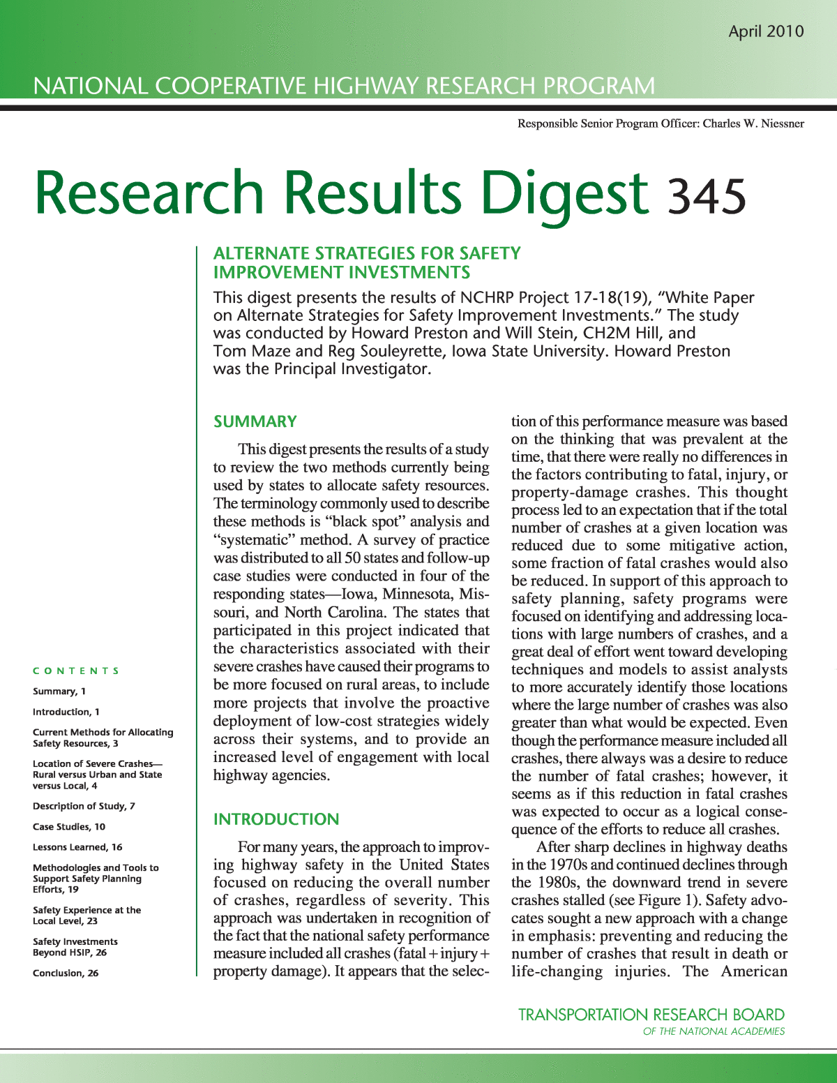
2Association of State Highway and Transportation Officials (AASHTO) and the Federal Highway Administration (FHWA) provided national leader- ship on this change in emphasis. AASHTOâs Strategic Highway Safety Plan (SHSP), first published in 1997, raised two important issues. First, if the national objective truly was a reduc- tion in the number of highway deaths and serious injuries, then the safety performance measure needed to change. Instead of attempting to reduce fatal crashes as a byproduct of programs meant to address all crashes, the focus of the safety programs should be on severe crashes because the factors that contribute to them are different than the factors that contribute to crashes as a whole. Current safety research indicates that, viewed collectively, most crashes involve multi- ple vehicles and occur at lower speeds in urban areas. Severe crashes, however, more often involve a single vehicle and occur at higher speeds in rural areas. Second, AASHTO acknowledged that focusing safety investments only on state highway systems has not been the most effective way to address safety. National crash statistics overwhelmingly suggest that to improve the effectiveness of safety programs, states need new partners in a more comprehensive approach to safety. State safety programs need to address all road systems and more actively engage local road authorities in the statewide safety planning processâstate systems may carry the bulk of the vehicle miles travelled, but local systems account for as much as 90% of total road miles and 60% of fatal crashes. Ignoring the percentage of fatal crashes on the local system is not the most effective approach to achieving statewide fatal crash reduction goals. In 2005, Congress enacted the Safe, Account- able, Flexible, Efficient Transportation Equity Act: A Legacy for Users (SAFETEA-LU), the current federal transportation bill. This legislation doubled the size of the federal Highway Safety Improvement Program (HSIP) to approximately $1.3 billion per year. FHWA published its guidelines for the statesâ Strategic Highway Safety Plans: A Championâs Guide 0 10,000 20,000 30,000 40,000 50,000 60,000 1965 1970 1975 1980 1990 19951985 20052000 2010 Year 0 1 2 3 4 5 6 Fatalities Fatality Rate (deaths/HMVMT) Figure 1 National fatality total and fatality rate trends, 1965â2008.
3to Saving Lives.1 This document provides states with guidance for complying with the safety provisions of the legislation. A key requirement of SAFETEA-LU is that each state must prepare an SHSP that docu- ments its process for reducing the number of fatal and serious-injury crashes across the entire roadway system, regardless of jurisdiction (management by state or local agency). FHWA also implemented a policy change to HSIP that revised the objective of the program from reducing highway crashes in general to specifically emphasizing the prevention of fatal and serious- injury crashes. This change in emphasisâfrom all crashes to severe crashesâpresents a new challenge to the professionals implementing safety programs within the states. Because of the random, widely distributed nature of severe crashes, it is difficult to identify specific at-risk locations. For example, in Minnesota, approximately 33% of fatal crashes (190 per year) involve a single vehicle running off the road, 75% of these (145 per year) are in rural areas, and 62% of these (90 per year) are on the local system. However, this system is made up of over 45,000 miles of two-lane highways, which results in a density of 0.002 fatal road-departure crashes per mile per year. This statistic raises two questions: are all of these miles equally at risk for severe crashes and, if not, how can the locations most at risk for severe crashes be identified as candidates for safety investment? To address these questions and truly focus on reducing the most severe crashes, new approaches and analytical techniques are required. CURRENT METHODS FOR ALLOCATING SAFETY RESOURCES There are currently two methods available to the states for allocating safety resources. These methods are commonly referred to as (1) the âblack spotâ analysis method and (2) the âsystematicâ method. Black Spot Analysis Black spot analysis has been most commonly used by transportation agencies in the United States for identifying candidate locations for safety investment. The objective of black spot analysis is to find locations that exhibit unusually high crash frequencies or crash rates. The crash data are then analyzed and problem locations are prioritized and ranked. Infrastructure- based countermeasures, such as improving intersec- tion geometry or traffic control devices, are then applied to address safety deficiencies at these specific locations. The technical analysis normally considers all crashes because severe crashes are too rare (fatal and A-injury crashes generally account for less than 2% of all crashes), random, and widely distributed geo- graphically to efficiently identify specific problem locations. However, the use of all crashes as the safety performance measure generally points ana- lysts toward locations with high traffic volumes in urban areas. As a result, common black spot loca- tions are intersections, particularly signalized inter- sections along multi-lane urban arterial roadways (see Figure 2). Black spot analysis is clearly a necessary compo- nent of a comprehensive program to improve the safety of the nationâs highways. In urban areas, where traffic volumes and crash frequencies are high, black spot analysis will likely continue to be the most com- mon method utilized for allocating safety resources. Intuitively, it seems to make sense to target limited safety funds at locations that have documented safety deficiencies. However, black spot analysis has not proven effective at reducing the fatal and serious- injury crashes that are widely distributed across the roadway systemâcrashes that are not concentrated Figure 2 Example of a typical urban black spot location. 1 FHWA, NHTSA, FMCSA, FTA, and FRA. Strategic High- way Safety Plans: A Championâs Guide to Saving Lives. U.S. DOT, 2006.
4enough to identify candidate sites for improvement through a process that focuses on the total number of crashes. The Systematic Method The systematic method is being added by a num- ber of states to their safety planning efforts to better address the very low density of severe crashes in rural areas and to complement the black spot component of their programs. The objective is to identify candidate sites for a wide deployment of lower cost safety mea- sures over many miles of roadway segments, corri- dors, or even over the entire roadway system. Road-departure crashes are a good example of where the systematic approach is beneficial. Road- departure crashes account for 53% of fatal crashes in the United States, but they are most common on rural, high-speed roadways.2 These crashes normally involve a single vehicle and are widely distributed geographically. (As was previously mentioned, the density of fatal road-departure crashes in Minnesota is 0.002 per mile.) Lower cost countermeasures, such as shoulder rumble strips (see Figure 3) and improved roadway delineation, can be implemented on a more systemwide basis. A number of states have indicated that they expect this approach to be more effective for reducing these types of widely distributed severe crashes. LOCATION OF SEVERE CRASHESâRURAL VERSUS URBAN AND STATE VERSUS LOCAL A closer look at where severe crashes occur pro- vides further support for including systematic approaches in highway safety programs. Table 1 illustrates the high percentage of fatalities that occur on rural roads. In 39 states, 50% or more of highway deaths are occurring on rural highways. In 20 of those states, 70% or more of highway deaths are on rural roads. Nationwide, 56% of highway fatalities occur on rural roads. Traffic volumes are much lower on rural roads; as a result, crash frequencies at rural locations are usu- ally too low to trigger a safety improvement based on designation as a black spot. For example, rural inter- sections in Minnesota average around 0.5 crashes per year and 0.01 fatal crashes per year. Most black spots are in urban areas or other densely traveled corridors while the majority of fatalities are in rural areas with lower traffic volumes. It is clear that the states expect a systematic approach would be necessary to address the high number of severe crashes that are widely scattered across rural roadways. As states shift a portion of safety resources to lower cost systematic safety improvements on rural highways, another important question is raised: how should resources be shared with local agencies, which have jurisdiction over a large percentage of the nationâs rural highway system? Most local agencies have no staff trained in safety planning and no expe- rience competing for funds specifically directed at improving highway safety. Furthermore, most local agencies have historically devoted their entire capital improvement programs to construction and mainte- nance of their systems. Table 2 documents the estimated distribution of fatalities between highways managed by a state trans- portation agency and roads managed by county, city, or other local units of government (note that the FARS data do not specify the roadway jurisdiction. As a result, the state versus local split was inferred from the route signing field. For example, interstate highways were assigned to the state list and county roads were assigned to the local agency list). Most states have a significant percentage of severe crashes occurring on local highways. In 30 states, 40% or more of highway deaths are occurring on the local system. It is clear that providing local highway agen- cies with technical and financial resources is an important component of a comprehensive statewide highway safety plan. Figure 3 Example of a typical rural lower cost safety countermeasure. 2 2007 data from the Fatal Analysis Reporting System (FARS) published by the National Highway Traffic Safety Administra- tion (NHTSA).
5Table 1 Rural versus urban highway fatalities Location Rural Urban Unknown Total State Number Percent Number Percent Number Percent Number Alabama 726 65 380 34 4 <1 1,110 Alaska 44 54 38 46 0 0 82 Arizona 516 48 555 52 0 0 1,071 Arkansas 496 76 153 24 0 0 649 California 1,496 37 2,499 63 0 0 3,995 Colorado 316 57 238 43 0 0 554 Connecticut 47 16 249 84 0 0 296 Delaware 71 61 46 39 0 0 117 District of Columbia 0 0 44 100 0 0 44 Florida 1,257 39 1,942 60 14 <1 3,213 Georgia 836 51 737 45 68 4 1,641 Hawaii 64 46 74 54 0 0 138 Idaho 202 80 50 20 0 0 252 Illinois 501 40 747 60 0 0 1,248 Indiana 569 63 329 37 0 0 898 Iowa 357 80 89 20 0 0 446 Kansas 326 78 90 22 0 0 416 Kentucky 677 78 187 22 0 0 864 Louisiana 520 52 473 48 0 0 993 Maine 164 90 19 10 0 0 183 Maryland 245 40 369 60 0 0 614 Massachusetts 36 8 398 92 0 0 434 Michigan 642 59 445 41 0 0 1,087 Minnesota 352 69 158 31 0 0 510 Mississippi 629 71 255 29 0 0 884 Missouri 686 69 306 31 0 0 992 Montana 263 95 14 5 0 0 277 Nebraska 205 80 51 20 0 0 256 Nevada 122 33 248 66 3 1 373 New Hampshire 105 81 24 19 0 0 129 New Jersey 119 16 605 84 0 0 724 New Mexico 302 73 111 27 0 0 413 New York 672 50 660 50 0 0 1,332 North Carolina 1,226 73 450 27 0 0 1,676 North Dakota 103 93 8 7 0 0 111 Ohio 815 65 440 35 0 0 1,255 Oklahoma 540 70 226 30 0 0 766 Oregon 342 75 113 25 0 0 455 Pennsylvania 765 51 726 49 0 0 1,491 Rhode Island 8 12 61 88 0 0 69 South Carolina 966 90 111 10 0 0 1,077 South Dakota 127 87 19 13 0 0 146 Tennessee 699 58 512 42 0 0 1,211 Texas 1,894 55 1,565 45 7 <1 3,466 Utah 189 63 110 37 0 0 299 Vermont 63 95 3 5 0 0 66 Virginia 612 60 414 40 1 <1 1,027 Washington 353 62 218 38 0 0 571 West Virginia 363 84 69 16 0 0 432 Wisconsin 502 66 254 34 0 0 756 Wyoming 124 83 26 17 0 0 150 U.S. Total 23,254 56 17,908 43 97 <1 41,259 SOURCE: 2007 data from the Fatal Analysis Reporting System (FARS).
6Table 2 Fatal crashes by jurisdiction (highways managed by a state transportation agency versus highways managed by local agencies) Jurisdiction State Agency Local Agency Unknown State Number Percent Number Percent Number Percent Total Alabama 623 56 486 44 1 <1 1,110 Alaska 38 46 41 50 3 4 82 Arizona 462 43 549 51 60 6 1,071 Arkansas 515 79 134 21 0 0 649 California 1,718 43 2,276 57 1 <1 3,995 Colorado 357 64 197 36 0 0 554 Connecticut 212 72 84 28 0 0 296 Delaware 73 62 44 38 0 0 117 District of Columbia 4 9 40 91 0 0 44 Florida 1,956 61 1,242 39 15 <1 3,213 Georgia 1,010 62 627 38 4 <1 1,641 Hawaii 83 60 51 37 4 3 138 Idaho 148 59 104 41 0 0 252 Illinois 761 61 487 39 0 0 1,248 Indiana 497 55 401 45 0 0 898 Iowa 210 47 236 53 0 0 446 Kansas 242 58 174 42 0 0 416 Kentucky 743 86 121 14 0 0 864 Louisiana 803 81 190 19 0 0 993 Maine 117 64 66 36 0 0 183 Maryland 438 71 175 29 1 <1 614 Massachusetts 222 51 212 49 0 0 434 Michigan 432 40 655 60 0 0 1,087 Minnesota 267 52 243 48 0 0 510 Mississippi 497 56 387 44 0 0 884 Missouri 759 77 233 23 0 0 992 Montana 212 77 65 23 0 0 277 Nebraska 137 54 119 46 0 0 256 Nevada 147 39 211 57 15 4 373 New Hampshire 78 60 51 40 0 0 129 New Jersey 330 46 394 54 0 0 724 New Mexico 251 61 155 38 7 2 413 New York 601 45 731 55 0 0 1,332 North Carolina 777 46 899 54 0 0 1,676 North Dakota 57 51 54 49 0 0 111 Ohio 668 53 587 47 0 0 1,255 Oklahoma 526 69 240 31 0 0 766 Oregon 233 51 222 49 0 0 455 Pennsylvania 1,215 81 276 19 0 0 1,491 Rhode Island 36 52 33 48 0 0 69 South Carolina 593 55 481 45 3 <1 1,077 South Dakota 83 57 63 43 0 0 146 Tennessee 807 67 404 33 0 0 1,211 Texas 1,654 48 1,811 52 1 <1 3,466 Utah 205 69 94 31 0 0 299 Vermont 38 58 28 42 0 0 66 Virginia 630 61 396 39 1 <1 1,027 Washington 275 48 294 51 2 <1 571 West Virginia 302 70 130 30 0 0 432 Wisconsin 354 47 402 53 0 0 756 Wyoming 118 79 32 21 0 0 150 U.S. Total 23,514 57 17,627 43 118 <1 41,259 SOURCE: 2007 data from the Fatal Analysis Reporting System (FARS).
7DESCRIPTION OF STUDY The aim of the study was to provide answers to key questions by synthesizing current practices in allo- cating safety resources in the United States. A survey of practice was distributed to all 50 states to gain a better understanding of the extent to which states are using black spot and systematic methods. Because the systematic approach is a relatively new concept in the United States, agencies are in the early stages of applying it. There are questions regarding what per- centage of safety budgets should be devoted to each approach. How should states allocate their limited resources to achieve the greatest safety improvements? A good first step in answering these questions is to look at the current state of practice across the country. In addition, the states were asked to provide infor- mation related to safety-resource allocation based on jurisdictionâstate highways under the jurisdiction of the state transportation agency versus local highways under the jurisdiction of county, city, or other local agencies. Follow-up case studies were conducted with four of the responding statesâIowa, Minnesota, Missouri, and North Carolinaâto gain a more in-depth under- standing of how these states are striving to balance the two approaches. On January 27, 2009, a survey of practice was mailed out to all state traffic safety engineers. A total of 25 states responded (see Figure 4), and the results are summarized in this section. The survey consisted of the following questions: 1. Approximately how large is your stateâs safety improvement budget? We recognize that your agencyâs safety improvement may not all come from safety improvement programs but instead safety improvements are incorporated into design guidance or policy. However, only provide the discretionary improvement bud- get. Please add explanation if necessary. 2. Are there established method(s) that your state uses to determine where safety dollars will be spent? This may include severity or rate rank- ing methods of high-crash locations. It may also include systemwide improvements such as edge line or centerline rumble strips for the whole system regardless of whether a crash has occurred. Please add explanation if necessary. 3. How are your stateâs districts/regions/etc. involved in choosing safety projects? Is your stateâs safety funding administered at a cen- tralized location, or are funds distributed to the districts/regions by formula? 4. What portion of your stateâs safety improve- ment budget is used to fund safety improve- ments at high-crash locations (black spot analysis)? 5. What portion of your stateâs safety improve- ment budget is used to fund systemwide improvements (rumble strips, median cable barrier, signing, pavement marking improve- ments, delineation, etc.) throughout the whole system whether or not a crash has occurred at a specific location (systematic improvements)? 6. Has the level of safety improvement funding in your state allocated through black spot analysis and through systematic improve- ments changed in recent years? Please explain. 7. Do you share or grant federal safety funds with local (cities and counties) or regional jurisdic- tions to make roadway safety improvements? Safety Improvement Budgets Discretionary safety improvement budgets vary greatly across the United States. Budgets reported from the 25 state respondents are illustrated in Figure 5. ⢠Seven states, which are generally geographi- cally smaller or less populous, have budgets in the $5 million to $15 million range. Figure 4 States responding to survey of practice (responding states shaded).
8⢠Ten states have budgets ranging from $15 mil- lion to $30 million. ⢠Nine states have budgets ranging from $30 mil- lion to $55 million. ⢠California has, by far, the largest safety budget, with an annual reserve of $200 million. The amount of Californiaâs budget actually spent each year varies based on the number of projects that meet qualifying criteria. ⢠The average budget for the 25 states that responded to the survey is $33.1 million. Methods for Determining Where Safety Dollars Are Spent Most of the states reported an analytical method based on crash data that also includes a ranking/ prioritization component. Ranking based on benefit- cost analysis is a common method. Some interesting trends include the following: ⢠Most states reported that money is being allo- cated for improvements at spot locations based on crash history as well as for more proactive systemwide improvements. ⢠Increased focus is being given to fatal and serious-injury crashes, which influences how safety funds are allocated. ⢠SHSPs are another influence. For example, Michigan reported that âeach submitted proj- ect must address serious injuries and fatal- ities and fit into one of the focus areas of the SHSP.â South Dakota noted that road- departure crashes were identified as the lead- ing cause of fatalities in its SHSP, and they are focusing on investments that target that particular crash type. Involvement of Districts/Regions Nearly all of the respondents reported that safety programs are administered centrally, but with signifi- cant input from districts/regions. In many cases, the districts submit candidate locations or projects for safety funding that are then reviewed, prioritized, and approved by safety staff or committees at the agencyâs 0 50 100 150 200 Ark an sa s Ca lifo rni a Co lor ad o Ha wa ii Iow a Ka ns as Ke ntu cky Lo uis ian a Ma ssa ch us ett s Mi ch iga n Mi nn es ota Mi sso uri Mo nta na Ne w H am ps hir e Ne w M ex ico Ne w Y ork No rth Ca rol ina No rth Da ko ta Or eg on Pe nn syl va nia So uth Ca rol ina So uth Da kot a Te nn es se e Ve rm on t Vir gin ia $ M illi on Figure 5 Safety improvement budgets of the 25 responding states.
9headquarters. Seven states indicated a distribution of funds to districts by formula. Funding at High-Crash Locations versus Systemwide Improvements As illustrated in Figure 6, most states target their safety funds at high-crash locations. Some inter- pretation of the responses was required as some states provided a numerical percentage, while others provided a more explanatory response. For this rea- son, the states are grouped into the three ranges shown in Figure 6. The survey asked about budgets specifically intended for safety improvements. Several states indi- cated that some systemwide safety improvements are accomplished through other funding sources, such as 3R and regular construction budgets. There is a clear trend toward increasing the pro- portion of safety funding to systemwide improve- ments. Fifteen of the 25 respondents indicated that the percentage of money allocated to systemwide improvements either had already increased or would be increasing, based on in-progress policy reviews. Reasons for the shift include the following: ⢠Changes in priorities and strategies that resulted from the strategic highway safety planning process. ⢠The effectiveness of certain systemwide strate- gies for reducing severe road-departure crashes such as shoulder rumble strips and cable median barriers. ⢠Increased weighting of fatal and serious-injury crashes, which has lowered the priority of some intersection black spots. ⢠A large number of serious crashes occurring on rural and local roads that are widely and ran- domly dispersed across the system. Cost Sharing with Local Agencies The amount of safety funding shared with local agencies varies greatly and is summarized in Figure 7. ⢠Seven states indicated that no federal funds are shared with local agencies (one has a state- funded program that allows local applica- tions). One reason for this cited by two states was that the federal aid process is cumbersome for the relatively small amount of funding that is available. ⢠Eight states indicated that local jurisdictions can submit candidate projects or locations that compete or are ranked against the candidates from the state highway system. The amount allocated to local agencies varies from year to year, and no typical or average amounts were indicated. ⢠Four states indicated specific allocations to local jurisdictions. California and Minnesota have the highest local share with a 50-50 split of federal funds. ⢠Three states indicated that the entire public road system is analyzed and that safety funds are distributed accordingly. Louisiana stated that Figure 6 Shares of state safety funding targeted systemwide versus at high-crash locations. 100% High-crash locations Louisiana Missouri Tennessee Arkansas Colorado Kansas Kentucky Montana New York Oregon Pennsylvania South Dakota Vermont Virginia Minnesota (non-metro) Iowa Michigan South Carolina Massachusetts Minnesota (metro) North Carolina 100% Systemwide Note: Unable to determine for California, Hawaii, New Hampshire, New Mexico, and North Dakota. Some of these reported that the distribution varied by year.
10 approximately 25% of fatal and serious-injury crashes occur on local roads and because of that 25% of the stateâs safety budget is allocated to local roads. South Dakota stated, âOur crash search is done on all public roads. The money is used where the problems are located.â ⢠The High Risk Rural Roads (HRRR) program is a popular means of cost sharing for several states. Three states indicated that 100% of these funds are allocated to local agencies. Another state indicated an allocation of $3.1 million. CASE STUDIES To gain a better understanding of how states are striving to find the proper balance between black spot and systematic methods, four states were contacted for more detailed information. The following case study summaries from Iowa, Minnesota, Missouri, and North Carolina illustrate a range of practices for how HSIP and other funds are being allocated to improve highway safety in each of the states. Iowa Case Study Black Spot versus Systematic Methods Iowa reported an approach that combines sys- tematic and black spot methods in terms of allocat- ing HSIP funds. The high-priority strategies, which are rural road edges and cable median barriers, were selected through a systemwide analysis. When spe- cific projects are selected and prioritized for imple- mentation of these strategies, crash data are used to identify roadway segments that have historically had the greatest problems. Rural versus Urban Funding Approximately 90% of HSIP funds are spent on rural roads. In addition, Iowa makes significant sys- tematic improvements through the use of non-safety funding. With funding from the 3R program, paved shoulders and shoulder rumble strips are being added to rural state highways with average daily traffic (ADT) greater than 3,000 vehicles per day (VPD). This work is done in conjunction with resurfacing or other pavement rehabilitation projects. State versus Local Funding HSIP funds are available for projects developed by local agencies for implementation on local sys- tems. However, few local agencies avail themselves of this opportunity due to a dislike for federal report- ing requirements and the fact that Iowa has a separate state-funded safety program with less paperwork. This program is funded through 0.5% of the State Road Use Tax Fund, and 70% of this amount is directed to safety projects developed by local agen- cies for implementation on local roads. Iowaâs over- all safety budget, including both federal funds and state funds, directs approximately 18% of safety funds toward projects on local roads. SHSP Considerations Iowaâs SHSP identifies lane departure, rural expressway (four-lane divided) intersections, and safety corridors as the infrastructure-based emphasis areas. These selections influenced the current focus on systematic improvements on rural roads. The driver behavior strategies identified in the SHSP are seat belt enforcement (including at night Figure 7 Relative levels of cost sharing with local jurisdictions. Massachusetts Tennessee Vermont Higher cost share with locals Arkansas Iowa Kentucky Missouri Oregon Pennsylvania California Kansas Louisiana Michigan Minnesota South Carolina South Dakota Lower cost share with locals Moderate cost share or locals allowed to compete Colorado Hawaii Montana New Hampshire New Mexico North Carolina North Dakota Virginia New York
11 and on rural gravel roads) and targeted DUI and speed enforcement (in safety corridors identified in the 5% process). Iowa is investigating flexing HSIP to fund additional enforcement activitiesâpotentially five new State Patrol officers and vehicles. Organizational Structure, Funding Mechanisms, and Evaluation In terms of allocating HSIP funds, Iowa has a cen- tralized organization. The central officeâs traffic and safety staff is responsible for both program and proj- ect development. The safety program and proposed projects are reviewed with district staff, but final deci- sions relative to implementation rest with the central office. The Iowa Department of Transportation (DOT) prepares a safety program evaluation as required by FHWA. Individual projects are assessed as part of this evaluation. In addition, the Iowa DOT is working with Iowa State University on evaluation of several systematic strategiesâshoulder paving and enhanced curve delineation and warning. The distribution of funds is not based on a for- mula. The actual allocation is subjectiveâbased on need, the specific strategy selected, and the 5% process. Projects are prioritized by benefit-cost analy- sis consistent with requirements for reporting project evaluations to FHWA. HSIP Approach: Strengths, Weaknesses, and Potential Improvements The strengths of the current HSIP approach were identified as the following: ⢠Multidisciplinary approach. ⢠Consideration of driver behavior issues. ⢠Good return on safety investments as a result of the data-driven effort to connect crash causa- tion, safety emphasis areas, priority strategies, and specific projects. ⢠Good data. Reasonably accurate crash data are available for all roads. This allows strate- gic safety investments in the local system. The weaknesses of the current HSIP approach were identified as the following: ⢠Concerns about statistical reliability due to the small number of severe crashes. The Iowa DOT is using 8 to 10 years of data in an effort to address sample size. ⢠Lack of a consistent, systematic method for identifying potential sites for safety improvement. ⢠Underfunding of safety investment on the local system. Between HSIP and state-funded safety programs, about 82% of available funds are spent on the state system, but almost 50% of the fatal crashes occur on the local system. Improvements to the current HSIP approach that are being considered are developing a process for identifying sites with potential for safety investment and continuing to work toward a more systematic deployment of safety strategies. Minnesota Case Study Black Spot versus Systematic Methods Minnesota reported an approach with HSIP funds that is predominantly based on black spots in the Minneapolis/St. Paul metropolitan area, where crash densities are higher, and predominantly sys- tematic in the rest of the state, where crash densities are lower. Ninety percent of fatal crashes occur on rural roads, a circumstance that supports the strong systematic component of Minnesotaâs program. In addition to the $20 million per year in HSIP funds, Minnesota has two other safety programs. The Central Safety Fund (incentive dollars from the National Highway Traffic Safety Administration [NHTSA]) has previously invested $5 million to $10 million per year in projects including cable median barriers, shoulder rumble strips, and targeted speed enforcement. Several Minnesota Department of Transportation (Mn/DOT) Districts have also invested $1 million to $5 million per year in non- safety construction funds to add safety features to larger construction projects. Rural versus Urban Funding Forty percent of safety funds go to the Metro District, where 90% are spent on urban highways. Sixty percent of safety funds go to the seven districts that make up the rest of the state. Of these funds, 80 to 90% are spent on rural roads. A typical rural safety project includes systematically enhancing the delineation at high-priority horizontal curves (see Figure 8).
12 State versus Local Funding Minnesota has one of the strongest programs in the nation, in terms of sharing safety funds with local units of government. Safety funds distributed to each district are split between the state and local systems based on the fraction of fatal and A-injury crashes. Statewide, 40 to 50% of the stateâs safety funds support projects on the local system. SHSP Considerations Minnesotaâs SHSP identified road-departure crashes in rural Minnesota and intersection-related crashes in the metro area as the top priorities. The road-departure crashes tend to be widely dispersed across many miles of the rural system and are best addressed with systematic approaches. The intersec- tion crashes in the metro area are concentrated at signalized intersections along urban arterials and are best addressed using a black spot approach. Emphasis areas based on driver behavior include seat belt usage, impaired driving, speeding, and young drivers. Mn/DOT is preparing to request per- mission from FHWA to flex a portion of its safety funds to pay for targeted speed enforcement. Organizational Structure, Funding Mechanisms, and Evaluation Mn/DOT is a decentralized organization, and all project definition and development is the responsibil- ity of the eight districts. However, the safety program is more collaborative. The central office manages the program and selects projects submitted by the dis- tricts for inclusion in the program. The districts iden- tify and develop the projects. Mn/DOT prepares an annual program review, as required by FHWA. Specific projects are evaluated using simple before-after analysis. Mn/DOT is also preparing to conduct systemwide analysis of system- atic strategies. The distribution of funds is based on a formulaâ each district receives funds based on its fraction of fatal and A-injury crashes. Within each district, funds are split again based on the fraction of fatal and A-injury crashes that occur on the state system ver- sus the local system. Benefit-cost analysis is used to rank improvements based on black spots (primarily in the Metro District). Benefit-cost analysis is not used for the systematic-based improvements that are predominantly implemented on the rural system. HSIP Approach: Strengths, Weaknesses, and Potential Improvements The strengths of the current HSIP approach were identified as the following: ⢠Local system participationâdedicating safety funds for projects on the local system of high- ways. Local highways have almost as many fatal crashes as rural state highways and a 30% higher fatal crash rate. ⢠Good data and a good crash analysis system for state highways. Mn/DOT has the ability to merge crash data, and the system design fea- tures data sets. ⢠Good data and a good crash analysis system for local highways. MnCMAT, a GIS-based crash analysis tool, has been distributed to all local highway agencies. ⢠Effective distribution of safety funds. ⢠The focus of the safety program in Minnesota is on deploying stand-alone projects on a systemwide basis and, when supported by crash data, cost-effective spot safety improve- ments. All projects selected for safety funding are the result of a data-driven analysis. The weaknesses of the current HSIP approach were identified as the following: ⢠Challenges in moving the safety program from 100% black spot to a more balanced approach. ⢠Lack of buy-in by designers in some districts to the idea that adding low-cost safety features (paved shoulders, shoulder rumble strips, etc.) Figure 8 Chevrons enhance curve delineation on a rural Minnesota highway.
13 to larger construction projects is worth the additional investment. ⢠Lack of safety expertise in local agencies has resulted in few âgoodâ projects being submit- ted in response to the HSIP solicitation. The following improvements to the current HSIP approach are being considered: ⢠Mn/DOT is in the process of initiating a safety planning effort in all 87 counties in Minnesota to address county engineersâ lack of experience conducting systemwide safety analyses and safety project development and to provide tech- nical support to the counties for identifying spe- cific projects for implementation of systematic improvements. ⢠Mn/DOT is working on developing methods to identify sites with promise to support system- wide deployment efforts. Research is now underway on methods to prioritize rural high- way segments, rural horizontal curves, and rural STOP-controlled intersections based on crashes, geometric features, and traffic volume. ⢠Mn/DOT is working on developing a database to support project evaluations. Missouri Case Study Black Spot versus Systematic Methods Missouri reported that 75% of HSIP funds had his- torically been directed toward black spotsâprimarily intersections with a history of severe crashes. How- ever, since 2007, the focus has shifted to a more sys- tematic approach, and almost two-thirds of HSIP funding has been directed toward systemwide solu- tions, including shoulder improvements and edge line rumble strips on major roads. Missouriâs total safety program is a combination of HSIP, HRRR, and other diversion dollars. Historically, HSIP has focused on black spot intersections, HRRR has focused on road- departure crashes, and diversion dollars have paid for cable median barrier projects. Recently though, over 75% of the combined safety money has gone to sys- tematic methods. Missouri has made very strong progress with implementation of systematic improvements on the state roadway system by paying for them with non- safety funds. Specifically, Missouri has been a national leader in the installation of cable median barriers, with approximately 600 miles of barrier installed in the state by the end of 2009 (see Figure 9). Missouri has also invested heavily in reducing road-departure crashes by adding paved shoulders and rumble strips to the systemâapproximately 5,600 miles on high-priority state routes. These have also been paid for with non-safety funds. Rural versus Urban Funding The HSIP funding split is approximately 50-50 between urban and rural areas. This is influenced by the two large urban areas in the stateâSt. Louis and Kansas City. As mentioned previously, significant safety improvements, like cable median barriers and paved shoulders/rumble strips, have been financed with non-safety dollars. When factoring in total safety expenditures, the split shifts to a higher rural proportion. State versus Local Funding HSIP funds are not currently shared with local units of government. Missouri would consider proj- ects on the local system for HSIP funding but does not expect that they would rank highly enough to be funded based on current prioritization methods, which are primarily based on black spots and require meet- ing a benefit-cost threshold. However, with approx- imately 25% of fatal crashes occurring on local highways, Missouri has identified local units of gov- ernment as an important partner in further improving highway safety in the state. SHSP Considerations Missouriâs updated SHSP (2008) identifies road-departure and intersection crashes as its safety Figure 9 Cable median barrier on a Missouri road.
14 emphasis areas. The identification of road-departure crashes in the 2004 SHSP drove the systematic improvements that were made with other funding sources. It is hoped that the success of these efforts will allow Missouri to continue to transition HSIP funding toward a more systematic approach. In terms of enforcement, education, and emer- gency response, the primary driver behavior strategy identified in the SHSP is targeted enforcement. This effort is funded with non-HSIP dollars. The Mis- souri Department of Transportation (MoDOT) has not requested authorization to flex HSIP dollars and currently has no plans to do so, as there are significant needs in engineering/infrastructure improvements. Organizational Structure, Funding Mechanisms, and Evaluation In terms of allocating HSIP funds, Missouri has a decentralized organization. The central office pro- vides overall program management and sends crash data and a listing of high-priority intersections and roadway segments to the districts. The districts are responsible for project development and selection. The central office has input on each districtâs HSIP spending, but final decisions are made at the district level. Each district receives a specified percentage of HSIP funds. Within this amount, there are no caps on HSIP project costs. There is an annual program evaluation carried out by the MoDOT Traffic Division and Highway Safety Division. In terms of individual projects, each district is required to conduct a before-after study for each HSIP-funded project. Missouri uses a formula and a benefit-cost requirement for determining projects that are eligi- ble for HSIP funding. The formula is primarily based on the number of crashes, but also considers population and traffic volume. The benefit-cost ratio for a proposed project must be greater than 1.0. Mis- souri is reviewing this benefit-cost requirement as it relates to potentially funding a greater proportion of systematic improvements through HSIP. HSIP Approach: Strengths, Weaknesses, and Potential Improvements The strengths of the current HSIP approach were identified as the following: ⢠A Safety Quality Circle has been established, which is developing safety champions in the districts. The Safety Quality Circle is made up of central office and district staff. This group meets monthly to help transition the stateâs safety focus to more systematic, proactive approaches. ⢠MoDOT leadership has been safety focused and willing to devote substantial resources to adding safety features to larger projects. ⢠MoDOT has a very good relationship with FHWA. ⢠MoDOT has very good crash data, including the ability to analyze local systems. The weaknesses of the current HSIP approach were identified as the following: ⢠Lack of involvement with local governments. About 25% of fatal crashes are on the local sys- tem, but no safety funds have been directed to local roads. (Note that a fraction of the stateâs gas tax is dedicated to local roads, but this is used for construction and maintenance). ⢠MoDOT has yet to identify an approach or methodology for finding sites that are at risk but that have few or no crashes. The following improvements to the current HSIP approach are being considered: ⢠MoDOT is revising its safety program guide- lines to provide the Central Office with more oversight earlier in the project development process. ⢠MoDOT is working to establish a more direct link between the 2008 SHSP priorities and actual HSIP spending. ⢠MoDOT expects the HSIP to continue to tran- sition toward a more proactive, systematic approach as a result of the new focus on severe crashes and road-departure crashes. North Carolina Case Study Black Spot versus Systematic Methods North Carolina reported an HSIP approach that is predominantly black spot focusedâapproximately 90% of the program. Several systemwide improve- ments, primarily cable median barrier and shoulder rumble strips, are integrated into the overall effort. North Carolinaâs HSIP has evolved over the years and continues to be improved with each update. The Traffic Engineering Accident Analysis System
15 (TEAAS) and the capabilities of North Carolinaâs headquarters and division safety professionals have helped guide the development of the current approach. This approach identifies locations meeting or exceed- ing specific criteria, such as those with a high fre- quency of crashes or exceeding established severity thresholds (see Figure 10). The HSIP distributes about $28 million per year for safety improvements along both state and local roads in North Carolina. In addition, there is a state- funded black spot safety program that invests another $9.1 million per year. Rural versus Urban Funding North Carolina has a fairly even (50-50) distri- bution of safety funds between urban and rural areas. There are fewer, higher cost projects in urban areas and more, lower cost projects in rural areas. State versus Local Funding Local government projects are eligible for consid- eration for HSIP funding. Local projects usually involve collaboration with DOT division staff and are not independently submitted. Approximately 95% of HSIP funds go toward safety projects in the state system, which consists of 80,000 miles. There are 20,000 miles under the jurisdiction of local agencies. There is no single mechanism or methodology for evaluating local agency projects for HSIP fund- ing. They are evaluated on the basis of a benefit-cost analysis just like the other candidate projects in the state system. The final determination regarding the selection of a local project for HSIP funding is case dependent and negotiated. SHSP Considerations North Carolinaâs SHSP identified road departure, intersections, pedestrians/bicyclists, and bridges as emphasis areas. These emphasis areas have influ- enced both systematic and black spot efforts. North Carolina has an established black spot (corrective) program that has some flexible components to it. It is mature and successful. Most of the systematic efforts are countermeasure specific, such as median barriers, rumble strips on freeways, safety edges, clearance intervals, removal of late night flash for signals, and so forth. In terms of driver behavior, the North Carolina Governorâs Highway Safety Program has developed and manages grant-based behavioral safety pro- grams including seat belt and child safety seat usage programs, alcohol programs, and speed enforcement programs. North Carolina also continues to keep a motorcycle helmet law in place despite strong oppo- sition from user groups. Organizational Structure, Funding Mechanisms, and Evaluation North Carolina reported a partnership between its central office and regional offices located throughout the state. The central office administers the safety program and provides technical support to the regions in the form of crash data and identification of hazardous locations. The regions are responsible for conducting investigations, recommending counter- measures/treatments, developing projects, and coor- dinating projects through the construction phase. The central office determines which projects are selected for funding. The North Carolina Department of Transporta- tion (NCDOT) prepares an annual program review, as required by FHWA. There is also a Safety Evaluation Group that performs system, project, and treatment- specific evaluations and system studies. This group conducts a before-after analysis for each project, and, when enough projects of one type are available, an Empirical Bayes Analysis is conducted of the group. Programmed HSIP safety projects are filtered through an equity formula, which is used to distrib- ute the funds to the regions for North Carolinaâs Transportation Improvement Program (TIP). Due to the lower cost of most safety projects, the equity Figure 10 Example of North Carolina road with safety improvements: turn lanes at intersection and improved geometry.
16 formula is typically not a factor beyond the balancing of division-specific projects. North Carolinaâs FHWA-approved HSIP project programming process requires benefit-cost analysis of all safety projects. Projects are selected for pro- gramming based on benefit-cost ratios. HSIP Approach: Strengths, Weaknesses, and Potential Improvements The strengths of the current HSIP approach were identified as the following: ⢠The black spot component of the HSIP is refined yearly as additional data, research, and program evaluation feedback are imple- mented. This component is actively managed to ensure that at-risk sites are identified as well as necessary changes in the work process and field staff feedback mechanisms. This black spot component of the HSIP is also flexible. Each year, the black spot program identifies pattern locations that focus on lane departure (including specific lane departure wet and night warrants), intersection locations (with specific warrants to identify patterns of severe, frontal-impact, night crashes), bridge locations, and bike/pedestrian crash pattern locations. The program also identifies addi- tional focus areas: topics such as larger trucks, motorcycles, speed, alcohol, and others can be added to core focus areas. ⢠The systematic component of the HSIP is less formalized. However, as countermeasures are proven to be effective, policies and guidance will be developed that will encourage system- wide deployment. Examples include the median barrier program, rumble strips for free- ways, removal of late night flash from most signals, and adjustment of clearance intervals for all signals. The median crossover limited movement (J-turns) initiative is very success- ful and is entrenched in design and operational policies. Safety edge requirements are being pursued now. The weaknesses of the current HSIP approach are identified as the following: ⢠The systematic approach is less formal and not as aggressive as the mature black spot pro- gram. It can take a long time to implement a new systemwide initiative due to the large size of North Carolinaâs state-maintained highway system (80,000 miles), many stakeholders, and cost considerations. ⢠Most systemwide initiatives are funded with TIP money and are not limited to HSIP funding. However, this is a time-consuming (lengthy) and highly competitive process. The following improvements to the current HSIP approach are being considered: ⢠NCDOT acknowledges that continued imple- mentation of black spot improvements at cur- rent investment levels probably wonât drive the number of fatal crashes down substan- tially. As a result, there is an effort under way to investigate ways of transitioning NCDOTâs HSIP toward a more systematic deployment of strategies. ⢠NCDOT is considering deployment of new programs to direct safety funds to low-cost rural intersection improvements, to improve bicycle and pedestrian modules, and to further refine specialized query capabilities to sup- port safety investigations. LESSONS LEARNED The states that provided information through the survey of practice and the subsequent interviews made it clear that their highway safety programs are evolving and that the primary agent of change is the passage of SAFETEA-LU and the adoption of severe crashes as the new national safety performance mea- sure. SAFETEA-LU required the preparation of SHSPs, and all of the states had complied by the October 2007 deadline. The states indicated that the SHSP data-driven development process has helped focus their programs through the identification of their individual Safety Emphasis Areas, which has influenced the type of projects selected for HSIP funding. However, the participating states acknowl- edged that the adoption of severe crashes as the safety performance measure has had the most pro- found effect on their safety programs. Finding a BalanceâBlack Spot versus Systematic Methods The participating states indicated that prior to SAFETEA-LU their safety programs had been almost exclusively focused on finding and then
17 addressing black spotsâlocations with large num- bers of crashesâon the their system of highways. However, this process tended to direct safety invest- ments toward signalized intersections along high- volume, urban, multilane arterials. This historic type of safety investment was based on the theory that if crashes were mitigated at locations with high fre- quencies of crashes, some fatal crashes would be eliminated along with injury and property-damage crashes. Over time, it became apparent that fatal crashes were not decreasing, primarily because severe crashes are underrepresented in urban areas in general and particularly at signalized intersections along high-volume arterials on the stateâs highway system. Mn/DOTâs experience provides a good exam- ple of this phenomenon. Mn/DOT has annually published a Top 200 list of intersections along its 12,000-mile state highway sys- tem that is prioritized based on calculated crash cost (crash severity à adopted cost per crash). These inter- sections are overwhelmingly signalized (70%) and in urban areas (69%). Mn/DOT made it a practice to direct some of its HSIP funds every year toward the highest priority intersections on this list. However, Mn/DOT determined that this approach did not reduce the number of fatal crashes. The Top 200 intersections accounted for less than 10% of fatal crashes, and the annual number of fatal intersection- related crashes remained at approximately 200 per year over the 8-year period between 1998 and 2005. The national statistics are very clear: well over one-half of fatal crashes are in rural areas, and approx- imately one-half of these are on the local systemâ locations with little or no history of safety investment because for all practical purposes there are no black spots. The states recognize that the historic approach of reacting to black spots cannot be entirely effective given the new safety performance measure because most severe crashes are randomly distributed across thousands of miles of rural roads and at tens of thou- sands of rural intersections, where there is no history of previous severe crashes. As a result, the participat- ing states reported that they are attempting to tran- sition their HSIP from a focus on reacting primarily to black spots in urban areas to a program that includes a rural/urban split that reflects the distri- bution of severe crashes and a yet-to-be defined bal- ance between a reactive approach of investing at a few black spot locations and a proactive approach that deploys low-cost improvements widely across the rural system of highways. However, most of the participating states reported that their HSIPs still had a black spot focus. Iowa and North Carolina indicated that 50% and 90%, respec- tively, of their safety funding was directed toward locations with high frequencies of crashes. These states suggested that the reason for this continued focus on black spots was that the supporting analyti- cal process was more mature and better understood by technical staff. The states also indicated that they expected to transition to a more proactive approach as new analytical tools and techniques3 become avail- able and the number of black spots is reduced. Minnesota has adopted a unique approach in an attempt to find a balance between a reactive and proactive focus for its HSIP by adopting twin goals: 70% of Metro District safety funding will be directed to reactively addressing black spots in the Metro Dis- trict (where 70% of Minnesotaâs Top 200 intersec- tions are located) and 70% of rural districtsâ safety funding will be directed toward the proactive deploy- ment of low-cost strategies in the rural districts with their large system of rural highways and where only a few safety investments have been previously imple- mented (due to the lack of identified black spots). Minnesota provided the following data in support of its decision to pursue both proactive and reactive approaches: ⢠In Minnesota, 70% of all crashes are in urban areas, but 70% of fatal crashes are in rural areas. ⢠Rural crashes are more severe than urban crashesâthe fatality rate on rural roadways in Minnesota is more than 2.5 times the rate in urban areas. ⢠Fatal crashes in Minnesota are different than less severe crashes. The most common type of crash is a rear end (28%)âbut the most com- mon types of fatal crashes are run off road (34%), right angle (23%), and head on (17%). Rear-end crashes account for only 4% of fatal crashes. Addressing All Roads The participating states also indicated that the provision of SAFETEA-LU that requires the state- wide safety program and the underlying crash data 3 As an example, statistical techniques that account for regres- sion to the mean would likely improve the accuracy of estimates of expected numbers of crashes for a given location.
18 system to address all public roads has caused them to re-evaluate their programs and in some cases to fundamentally alter their approaches to involving local road authorities. Virtually all of these states indicated that historically their safety programs were open to participation by local authorities, and some even noted that their data systems were capable of identifying crash locations on the local systems. However, the most common response from the states was that they had never allocated safety funds for a project on the local system because the small number of crashes on the local system made it a low priority in their evaluation processes. Several states reported that subsequent to the passage of SAFETEA-LU and often with the encouragement of FHWA safety engineers, they revised their safety programs in order to increase the level of involve- ment with local road authorities (both from the perspective of providing technical assistance and directing safety funds toward projects on the local system). In the statesâ responses, the importance assigned to increasing the involvement of local road authorities varied. North Carolina assigned a lower level of importance to this issue because 80% of its roads are in the state system, whereas Iowa and Min- nesota assigned a high level of importance to this issue because only 10% of their roads are in the state system. The statesâ responses noted several significant achievements including the following: ⢠California (57% of fatal crashes on the local system) is in the process of having the Univer- sity of California (Berkeley) geo-code all fatal and severe-injury crashes as well as provide an interface with GIS to identify locations with concentrations of crashes. California also ded- icates one-half of its HSIP funds to safety proj- ects on local systems and provides technical assistance relative to the preparation of appli- cations for the competitive project selection process.4 ⢠Illinois (39% of fatal crashes on the local sys- tem) has added to the stateâs crash database the ability to locate all crashes on the local system, including output in a GIS format to identify crash locations. The Illinois Depart- ment of Transportation (IDOT) also provides safety training to local agencies and dedicates approximately 20% of its HSIP funds and all of its HRRR funds to safety projects on local systems.5 ⢠Iowa (53% of fatal crashes on the local sys- tem) has a mature, map-based, crash records system (the Crash Mapping Analysis Tool, CMAT, available to all local highway agen- cies, law enforcement, and private engineers) that covers all roads; individual crashes are spatially located by reference point along all roadways in each county in Iowa. The Iowa DOT also provides training for local engi- neers through an annual safety workshop, and it directs about 70% of a separate state-funded safety program to projects developed by local agencies for implementation on local roads. The 70% of the state safety funds directed to local projects amounts to approximately 18% of all safety expenditures. ⢠Louisiana (19% of fatal crashes on the local system) is implementing the Local Road Safety Program (LRSP), which is a partnership between the Department of Transportation and Development and the Local Technical Assis- tance Program (LTAP)/Technology Transfer Center. A key component of the LRSP includes adding two part-time traffic safety engineers to provide technical assistance to local agenciesâcrash analysis, safety training, and help with the application process for safety funds. Approximately 25% of the HSIP is directed toward projects on the local system.6 ⢠Michigan (60% of fatal crashes on the local system) created a Local Safety Initiative (LSI) in its Department of Transportation and has dedicated 2.5 engineering full-time equivalents to provide technical assistance to local agen- cies. LSI provides the RoadSoft Safety Mod- ule, which includes 10 years of crash data and output in a GIS format, to local agencies and maintains it. The Michigan Department of Transportation (MDOT) has partnered with the LTAP at Michigan Technical University to develop and provide safety training for local agencies and dedicates about one-third of its 4 T. McDonald and T. Welch. Support by State Departments of Transportation for Local Agency Safety Initiatives. Institute for Transportation, Iowa State University, July 2009. 5 Ibid. 6 Ibid.
19 HSIP funds and all of its HRRR funds to safety projects on local systems. ⢠Minnesota (48% of fatal crashes on the local system) has provided a local version of CMAT to all cities and counties. MnCMAT contains 10 years of data, and up to 73 data items are provided for each crash including route, loca- tion, date/day/time, severity, vehicle actions, crash causation, weather, road characteristics, and driver condition. Mn/DOT has also pro- vided technical assistance through a series of safety workshops around the state and has revised its approach to the HSIP. The safety fund is disaggregated by district based on the distribution of fatal crashes around the state, and within each district the funds are split based on the distribution of fatal crashes between the state and local systems. This new approach has directed more than 60% of HSIP funds to Mn/DOTâs rural districts, and almost 50% of the safety funds are reserved for projects devel- oped by local agencies for implementation on local roads. In addition to noting the lessons they have learned, the states indicated some challenges that will have to be addressed before inclusion of local road authorities in the safety planning process becomes routine. These challenges are developing methodologies and tools for identifying candidate sites for safety investment in rural areas and the lack of safety-related experience among the staff at the local road authorities. METHODOLOGIES AND TOOLS TO SUPPORT SAFETY PLANNING EFFORTS One of the key challenges identified by the par- ticipating states is that the analytical processes for identifying candidate sites for safety investments in rural areas (rural intersections and rural highway segments on both the state and local systems) are not well developed, and the basic processes are not understood by safety engineers and analysts. Most previous efforts to refine analytical processes have focused on improving the statistical methods for identifying high-crash locations. However, most of the rural locations where most of the severe crashes occur have had few or no crashes during a typical 3- to 5-year study period. For example, in Minnesota ⢠The average rural intersection averages 0.5 crashes per year and 0.01 fatal crashes per year, and no intersection in the state averages one fatal crash per year. ⢠The average two-lane rural state highway aver- ages 1.5 crashes per mile per year and 0.01 fatal crashes per mile per year. ⢠The average county highway averages 0.5 crashes per mile per year and 0.003 fatal crashes per mile per year. The point is that the mature analytical systems that safety professionals are familiar with are primar- ily focused on finding locations with unusually high numbers of crashes, which most often are not the locations where the majority of the severe crashes are actually occurring. In response to this challenge, state and national agencies have been working to identify at-risk rural locations by developing tools that are not based just on crash data but also take into account identifying features such as design characteristics and traffic volumes. Examples of these tools are discussed below. SafetyAnalyst This is a new suite of analytical tools for identi- fying and managing a systemwide program of site- specific improvements to enhance highway safety by cost-effective means. The package was devel- oped by FHWA and partner state and local agencies. The software can be used to identify the frequency and percentage of specific crash types systemwide, on particular segments of a road network, or at indi- vidual high-crash locations (black spots). The pro- gram can also be used to characterize the need for systemwide engineering improvements such as edge treatments and cable median barriers. A key expected benefit of SafetyAnalyst is automation of the man- ual safety analyses being conducted by some road authorities. The SafetyAnalyst package consists of six tools: ⢠Network screening ⢠Diagnosis ⢠Countermeasure selection ⢠Economic appraisal ⢠Priority ranking ⢠Countermeasure evaluation The network screening tool is used to identify sites that have the potential for safety improvement based on higher-than-expected crash frequencies. The diagnosis tool generates collision diagrams and helps the user understand the nature of collision patterns
20 that may exist at screened sites. The tool includes a diagnostic expert system that asks the user questions about specific sites and specific crash scenarios in order to suggest specific countermeasures, and the tool considers both engineering and human factors criteria. The countermeasures selection tool is inte- grated with the diagnosis tool and presents users with a suggested set of countermeasures for further consid- eration. The economic appraisal tool is used to assess the economic viability of each of the countermea- sures, using four economic appraisal methods. The economic appraisal tool also includes an optimization algorithm that can consider multiple sites and multi- ple candidate countermeasures at each site and then suggest a set of sites and countermeasures that pro- vides the maximum safety benefit within a user-spec- ified budget. The priority ranking tool is integrated with the economic appraisal tool and ranks the candi- date treatment sites and countermeasures using a range of economic, safety, and project cost measures. The SafetyAnalyst software tools require access to a database that includes roadway/intersection char- acteristics, traffic volumes, and crash data for the road network to be evaluated. Many of the data elements required for SafetyAnalyst should be readily avail- able within highway agencies, but some effort may be required to complete data assembly. SafetyAnalyst includes a data management tool to help import and manage the necessary data inputs. Information provided by the participating states indicates that only a few have decided to incorporate the use of SafetyAnalyst into their safety planning efforts and fewer yet plan to make the software an integral part of their efforts. In general, the comments provided by the states suggest that the very limited use of the software is due to the large data require- ments. Minnesota staff indicated that even though the SafetyAnalyst data requirements were based on their database, it took them more than a month to load and get the model running. Minnesota staff also indicated that they intend to use SafetyAnalyst for improving the identification of black spots but that the software was not capable of assisting them with identification of candidates for systematic improvements. Missouri indicated that it intends to incorporate SafetyAnalyst into its statewide safety planning efforts, is in the process of purchasing the license, and is working on making its intersection and segment characteristics databases compatible with the software requirements. Iowa and North Carolina indicated that they do not intend to use SafetyAnalyst to support their safety planning efforts and instead will continue to use and develop their own techniques and tools. The partici- pating statesâ final comments reflected a nearly uni- versal concern that SafetyAnalyst would not be used any time soon to assist with safety planning on local systems because local agencies would not have the necessary databases documenting roadway and inter- section features. United States Road Assessment Program (usRAP) This is a new methodology being developed by the AAA Foundation for Traffic Safety (AAAFTS) to evaluate safety improvement opportunities on a road network selected by a highway agency and to identify cost-effective safety improvements. The road network to be considered is selected by a participating highway agency in consultation with usRAP. Three protocols are included by usRAP: risk mapping, star ratings, and countermeasures selection. Risk maps only require information about severe crash locations and a limited amount of information on road- way features and traffic volume characteristics. While more reactive in nature, risk mapping provides a sys- temwide view of crash density, motorist risk, road per- formance, and potential for improvement. Star ratings do not require crash data and are based solely on road and traffic characteristics. Star ratings require as input approximately 40 key data elements related to safety. A unique aspect of the pro- tocol is that it does not require detailed, site-specific crash data, but relies on an inspection of roadway design features that can be done from a videolog. Countermeasures selection software is also pro- vided by usRAP and can be calibrated for applica- tion to the road network of any highway agency. The methodology requires assembling required data inputs (roadway and traffic characteristics) from new or existing video records while some elements may be obtained from existing roadway inventories. An evaluation of each location on the network is then provided by the usRAP software. Crash countermeasures are identified, crash reduc- tion benefits are computed, and a benefit-cost ratio is calculated to help prioritize the countermeasures. Nearly 70 common crash countermeasures are con- sidered by the software, including roadway improve- ments, median treatments, shoulder paving and widening, roadside improvements, and pedestrian and bicycle facilities. The software analysis tool provides a list of potential safety improvement projects, suggested
21 countermeasures, project location, estimated project cost, estimated project benefits (in terms of fatal and serious-injury crashes reduced and in monetary terms) and benefit-cost ratio. The usRAP risk-mapping protocol has been pilot tested in eight states, and the star rating protocol has been tested and validated against crash data in two states. These pilot studies have demonstrated the technical feasibility of the usRAP risk-mapping and performance-tracking protocols for states with good quality crash data. A third pilot study evaluating the application of the software and analytical processes in a state with more challenging data issues is nearing completion. Given the very limited testing to date, it is too early to forecast how widely this new method- ology will be deployed after the initial pilot tests. State Initiatives to Develop New Methodologies and Tools A review of the safety literature combined with conversations with state DOT staff and university researchers revealed a number of initiatives that are intended to fill the gap in the analytical process asso- ciated with identifying candidates for safety invest- ments in rural areas. New methodologies and tools are being developed, including statistical models and describing surrogates to crashes to assist with the efforts to find and prioritize at-risk locations on the rural systems where more than one-half of severe crashes occur, but where crash densities are very low. Examples of these initiatives in Iowa, Texas, and Minnesota are discussed below. Iowa Iowa State University is in the process of con- ducting a safety analysis of low-volume rural roads. The primary objective of the project is to develop a safety performance function for low-volume rural county highways and a new statistical model. The new model would then be incorporated into the Iowa Traffic Safety Data Service, which provides techni- cal assistance to county highway agencies, including preparation of maps and lists of at-risk locations and recommendations of potential safety improvement projects.7 Texas The Texas Transportation Institute at Texas A&M University studied horizontal curves along Texasâs farm-to-market road system.8 These curves were selected based on identification as at-risk locations that donât regularly show up using traditional âhot-spotâ techniques. In support of a system approach for find- ing and prioritizing the most at-risk curves, a relation- ship was developed between crash rate and curve radius (see Figure 11). Minnesota Mn/DOT has recently published research that analyzed three components of the stateâs rural high- way systemâhorizontal curves, STOP-controlled rural intersections, and two-lane highway segments. These features were selected for analysis because the data-driven process associated with Minnesotaâs 7 R. Souleyrette. âSafety Analysis of Low Volume Rural Roads in Iowaâ (research project in progress). Iowa State University, Iowa Department of Transportation. 85th% tangent speed = 60 mph Fatal + Injury + PDO Fatal + Injury Bonneson et al. (2007) Fitzpatrick et al. (2000) Figure 11 Curve crash rates as a function of radius.9 8 J. Bonneson, M. Pratt, J. Miles, and P. Carlson. Development of Guidelines for Establishing Effective Curve Advisory Speeds (FHWA/TX-07/0-5439-1). Texas Transportation Institute, Texas Department of Transportation, FHWA, U.S. DOT, Octo- ber 2007. 9 J. Bonneson, D. Lord, K. Zimmerman, K. Fitzpatrick, and M. Pratt. Development of Tools for Evaluating the Safety Implica- tions of Highway Design (FHWA/TX-07/0-4703-4). Texas Transportation Institute, Texas Department of Transportation, FHWA, U.S. DOT, 2007. K. Fitzpatrick, L. Elefteriadou, D. W. Harwood, J. M. Collins, J. McFadden, I. B. Anderson, R. A. Krammes, N. Irizarry, K. D. Parma, K. M. Bauer, and K. Pas- setti. Speed Prediction for Two-lane Rural Highways, (FHWA- RD-99-171). Texas Transportation Institute, FHWA, U.S. DOT, 2000.
22 SHSP identified rural curves, intersections, and segments as priorities based on the distribution of severe crashes. The research resulted in the iden- tification of analytical processes for identifying and prioritizing at-risk locations that would be candidates for the proactive deployment of low-cost safety improvements. The research projects identified the characteristics of the locations with crashes and then developed a process for prioritizing these types of locations across almost 53,000 miles of the rural state and local high- way systems based on the number of similarities with the features associated with locations with crashes. An example of this work, dealing with horizontal curves found the following: ⢠There are literally thousands of curves scattered across the state and county highway systemsâ itâs estimated that there are over 3,000 curves along the stateâs 8,000 miles of two-lane rural highways and over 26,000 curves along the 45,000 miles of rural county highways. ⢠Curves average about 0.1 crashes per year, and slightly more than one-half of the curves have had no crashes during a 5-year study period. ⢠Approximately 40% of the road-departure crashes occur in curves even though curves make up only about 10% of the system mileage. ⢠All curves are not equally at risk. Consistent with the work completed by the Texas Transportation Institute (FHWA/TX-07/0-5439-1),10 Mn/DOT found that radius could be used to find and prioritize at-risk curves. The crash rate in curves with radii greater than 2,000 ft approximates the average rate on two-lane rural roads, but as curve radius decreases, the crash rate increases. The crash rate at a radius of 1,500 ft is three times the system average, the crash rate is four times the system average at a radius of 1,000 ft, and the crash rate is eleven times the system average at 500 ft (see Figure 12). This research also found that 90% of fatal crashes and 75% of injury crashes occurred on curves with radii less than 1,500 ft. A methodology based on this curve radiusâcrash rate relationship was applied and refined as part of the preparation of a Countywide Safety Plan for Olmsted County, Minnesota. One of the key results of a data-driven analysis process was the finding that road-departure crashes on horizontal curves were overrepresentedâ40% of severe road-departure crashes occurred on curves, even though curves made up only 15% of rural county highway mileage. The methodology was used to evaluate all 241 curves on Olmsted Countyâs 324 miles of two-lane rural highways. The objective of the analysis was to iden- tify a subset of curves that are most at risk and then to develop a low-cost safety project involving a sys- temwide deployment. Curves were ranked based on two primary factors and three secondary factors. The primary factors were radius (it was determined that curves with radii between 500 and 1,500 ft had the highest fraction of severe road-departure crashes) and serious crashes. The three secondary factors were traffic volume (volumes between 500 and 2,500 vehi- cles per day had the highest fraction of curve-related crashes), presence of an intersection, and visual trap (see Figure 13). The exercise resulted in the ranking of 23 high-priority curves along the Countyâs rural highway systemâabout 10% of all rural curves in the County. Olmsted County subsequently used the results from this exercise to secure funding from Min- nesotaâs HSIP to proactively add chevrons at the 23 high-priority curves (see Figure 14). The research dealing with STOP-controlled intersections and two-lane highway segments came to a similar conclusionâall of these locations along rural systems are not equally at risk. In addi- tion, a methodology based on a combination of design features and traffic volume can be effec- tively used to develop a prioritized list of at-risk locations that can then become candidates for safety investment. Scott County, Minnesota, also prepared a High- way Safety Plan and identified crashes at rural STOP-controlled intersections as one of its safety emphasis areas. The crashes at these intersections account for approximately 16% of all severe crashes in the County. The challenge involved identifying the most at-risk intersectionsâsix severe crashes occur annually across almost 100 rural intersections. To help identify candidates for safety improvement, the County conducted a prioritization exercise that considered intersection characteristics that were demonstrated to be associated with intersections with crashesâskewed approaches, proximity to a horizontal curve, traffic volume, distance from the 10 J. Bonneson, M. Pratt, J. Miles, and P. Carlson. Development of Guidelines for Establishing Effective Curve Advisory Speeds (FHWA/TX-07/0-5439-1). Texas Transportation Institute, Texas Department of Transportation, FHWA, U.S. DOT, Octo- ber 2007.
23 last STOP sign (along the minor legs), presence of a rail crossing (on the minor leg), occurrence of intersection-related crashes, and commercial devel- opment. The exercise resulted in the ranking of 26 high-priority intersections (see Figure 15). SAFETY EXPERIENCE AT THE LOCAL LEVEL The participating states identified an addi- tional challenge that could be the most difficult to overcomeâthe lack of safety-related experience among the staff at the local road authorities. Due to their historic lack of involvement in statewide safety planning, county highway departments have little or no experience with safety analysis, the safety plan- ning process, the competitive funding process, or the development of safety projects. Mn/DOT found that even after it opened its safety program to the counties and dedicated almost one-half of HSIP funds to local system projects, many county engineers were reluc- tant to participate, and few of the projects submitted by the counties were consistent with the priorities established in the SHSP. In response to this challenge, Mn/DOT has just begun a statewide project to develop a safety plan for each of Minnesotaâs 87 counties, including a list of safety emphasis areas, a prioritized list of safety strategies, and a unique list of safety projects (the application of the high-priority strategies in the at-risk locations in each county) consistent with the stateâs SHSP. However, after completion of the county safety plans, it will still be the responsibility of the county engineer to respond to the HSIP solicita- tion, submit project descriptions and cost estimates to compete for HSIP funding, and then, if successful, to prepare the construction documents necessary to get to implementation. Iowa also identified county engineersâ lack of safety-related experience as an issue. Iowaâs response included establishing both a county safety liaison 2% 5% 15% 28% 27% 20% 3% 4% 10% 29% 27% 25% 4% 17% 17% 22% 11% 6% 1%0% 28% 11.1 3.8 2.9 1.1 1.5 0.7 0.9 0% 5% 10% 15% 20% 25% 30% 35% 0-500 500-1000 1000-1500 1500-2000 2000-2500 2500-3000 3000-3500 Radius Pe rc en ta ge (% ) 0 2 4 6 8 10 12 Length (~236,775 feet) VMT Severe Curve Crashes (18 total) Crash Rate Figure 12 Mn/DOT District 7 curve crashes disaggregated by radius (Source: Mn/DOT District 7 Highway Safety Plan). Figure 13 Visual trap at a horizontal curve.
K A B C PDO K A 7 CSAH 3 Mower Co - CSAH 6 1 295 1 0 0 0 0 1 0 800 1,250 Yes xxx 6 3,075 1 0 1 1 1 1 0 1,150 1,875 Yes xxx 3 1,150 0 0 1,150 1,050 Yes Yes xxxx 2 1,500 0 0 900 725 Yes Yes xxxx 4 3,200 0 0 1,050 1,500 Yes Yes xxx 6 1,600 0 0 1 0 0 0 0 800 1,100 Yes xxx 9 1,200 0 1 0 0 0 0 0 800 500 xxx 2 3,650 0 1 0 2 0 0 1 1,000 725 Yes xxx 5 2,150 0 0 1 0 0 0 0 1,100 1,025 Yes xxx 6 2,150 0 0 0 0 1 0 0 1,150 325 Yes xxx 3 2,100 0 0 1,850 800 Yes Yes xxx 5 1,000 0 1 0 0 2 0 1 850 1,350 Yes Yes xxxxx 6 1,150 0 0 850 1,250 Yes Yes xxxx 1 1,250 0 0 1 0 0 0 0 850 1,225 Yes Yes xxxx 2 1,250 0 0 800 1,250 Yes Yes xxxx 4 480 0 0 800 1,250 Yes Yes xxx 1 1,900 0 0 2 0 0 0 0 1,050 975 Yes xxx 3 1,900 0 0 1 0 0 0 0 1,150 1,075 Yes Yes xxxx 4 295 0 0 800 1,250 Yes Yes xxx 5 295 0 0 800 1,200 Yes Yes xxx 3 350 0 2 0 0 0 0 1 1,000 375 Yes xxx 3 400 0 0 850 1,275 Yes Yes xxx 4 1,200 0 0 0 1 0 0 4 -MnCMAT crash data, 2003-2007 -Curve #âs are based on the West to East and South to North road direction. 3 611 24 15 101 47 0 1,300 600 Yes Yes xxx None None None None None 63 CSAH 25 CSAH 3 - CSAH 22 64 CSAH 23 CSAH 19 - TH 42 65 CR 143 CSAH 11 - CSAH 19 CSAH 12 - Wabasha Co 71 CSAH 16 CSAH 1 - US 52 75 CSAH 18 52 CSAH 10 Chatfield City Limits - I-90 None 44 CSAH 6 CSAH 3 - US 63 41 CSAH 34 US 14 - CSAH 3 42 CSAH 3 CSAH 6 - CSAH 4 26 CSAH 5 Byron City Limits - Dodge Co (CSAH 17) 21 CR 133 55th St NW - CSAH 14 22 CSAH 3 CSAH 14 - CSAH 13 36th Ave NE - TH 42CSAH 220 None CSAH 11 CSAH 36 - CSAH 2 None 9 CSAH 4 CSAH 5 - CSAH 22 24 CSAH 12 US 52 - US 63 18 CrashesCorridor Weighted ADTCurve RankChevronsRadius Length Curve Visual Trap Intersection on Curve Severe RoR Corridor 11 CSAH 8 CSAH 6 - CSAH 35 DescriptionSegment None None Figure 14 High-priority curves (Source: Olmsted County, Minnesota, Highway Safety Plan, September 2009).
25 position at the Institute for Transportation at Iowa State University (which is also the LTAP Center for Iowa) and the Iowa Traffic Safety Data Service (ITSDS). The ITSDS provides local highway agencies with technical support for their safety planning efforts by filling the gap between what safety analysts can gather for themselves and what they can obtain from experts. This last point leads to one final thought relative to statesâ efforts to engage local road authorities. Even with extraordinary effort on the part of the states to involve local road authorities in the statewide safety planning process, expertise and effort are required of local road authority staff to achieve the desired out- come of high-priority safety strategies implemented at identified at-risk locations. However, a number of states said that they face a challenge beyond deciding whether or not to provide local authorities with crash data and technical assistance related to safety plan- ning or extending HSIP funds to projects on the local system. This challenge is the lack of technical staff at local agencies. In Missouri, for example, almost 90% of the counties have no county engineer. As a result, even if Missouri decided to change its approach to statewide safety planning by reaching out to local road authorities with technical assistance and fund- ing, it is possible that the local authorities would not have professional staff familiar with the process for guiding safety improvement projects from conception to completion. For insight on the issue of the presence, or lack thereof, of county engineers, the National Association of County Engineers (NACE) was con- tacted. NACE indicated that whereas Iowa, Min- nesota, and Washington have a county engineer in every county, the majority of states do not; at the local road authority level, most states are a mix of engi- neers and road superintendents with little formal edu- cation and no experience with safety planning. Skew Curve ADT Ratio STOP Sign RR Crossing Crash Development 29% 30% 34% 19% 1% 67% 4% Totals 1 Hwy 19 & CSAH 86 0.2 - 150,000 0.6% 2 0.6 - 111,000 1.0% 3 .0 6 2,097,000 9.3% 4 Hwy 13 & CSAH 2 .4 13 1,369,000 14.7% 5 Hwy 19 & CSAH 11 1.0 - 222,000 15.6% 6 Hwy 13 & CSAH 10 0.2 1 220,000 16.4% 7 0.3 - 133,000 17.0% 8 0.3 1 87,000 17.3% 9 CSAH 8 & CSAH 23 (North) CSAH 68 & CR 91 CSAH 8 & CSAH 23 (South) CSAH 46 & CR 62 CSAH 1 & CR 51 - - - 17.3% 10 CSAH 2 & CSAH 46 .2 6 2,373,000 26.7% 11 CSAH 2 & CSAH 91 .9 5 1,246,000 31.6% 12 Hwy 13 & CSAH 8 1 1 1 0 0.6 5 1,232,000 36.4% 13 CSAH 8 & CR 91 0.6 3 893,000 39.9% 14 CSAH 12 & CSAH 17 0.2 2 523,000 42.0% 15 Hwy 19 & CSAH 3 0.7 3 489,000 43.9% 16 Hwy 21 & CSAH 2 0.7 5 147,000 44.5% 17 CSAH 10 & CR 79 0.8 - 133,000 45.0% 18 Hwy 19 & CSAH 5 0.2 - 121,000 45.5% 19 Hwy 13 & CR 56 0.1 - 121,000 46.0% 20 CSAH 8 & CSAH 27 0.3 - 111,000 46.4% 21 Hwy 21 & CSAH 8 0.3 1 99,000 46.8% 22 CSAH 2 & CSAH 27 0.3 - 99,000 47.2% 23 CSAH 1 & CSAH 6 0.5 1 75,000 47.5% 24 Hwy 19 & CSAH 7 0.5 - 36,000 47.6% 25 CSAH 59 & CR 66 - - - 47.6% 26 CR 62 & CR 87 - - - 47.6% Crash Cost Cumulative Cost Crash RateRank Intersection Right Angle Crashes Figure 15 Scott County, Minnesota, systemwide rural intersection prioritization exercise (Source: Scott County Highway Safety Plan, March 2010).
26 SAFETY INVESTMENTS BEYOND HSIP A final issue worth mentioning is the effort sev- eral states are making to invest in safety features with resources beyond their HSIP funds. Actions in Missouri, Iowa, and Minnesota are summarized in the sections that follow. Missouri Missouri determined that 75% of its highway fatalities occurred on its state-maintained roads and that almost one-half of these occurred on the 5,600 miles that are designated âMajor Roadsâ (these roads account for 16% of the stateâs highway miles but carry 80% of the vehicle miles traveled). MoDOTâs director concluded that a systemwide application was the solution because chasing fatal crashes around MoDOTâs system could not be an effective strategy. Over the past several years, MoDOT has undertaken extensive renovation of its high-volume roads and has added safety features including more than 500 miles of cable median bar- riers to the Interstate routes and 6-in. edge lines, paved shoulders, and center and edge line rumble strips to two-lane rural roads. These safety features were added to many miles of major roads without using HSIP funds. Iowa The Iowa DOT has almost never directed HSIP funds toward safety projects on the local system. This is partly based on historic precedent, but is mostly because Iowa has a separate state-funded safety programâthe Traffic Safety Improvement Program (TSIP). TSIP funds are derived from 0.5% of the stateâs Road Use Tax, and approximately $5 million per year are available for three separate categories of projects: site-specific improvements; traffic control devices; and research, studies, and public information initiatives. State, county, and city jurisdictions are eli- gible to apply for the funding; about 70% of the pro- gram is directed to projects developed by local agencies for implementation on local roads. Exam- ples of projects selected for funding include various intersection improvements in metropolitan areas, the addition of street lighting at rural intersections, countywide deployment of chevrons at horizontal curves on rural county highways, and support for the Traffic and Safety Engineering Forum. Minnesota Minnesota has established a Central Safety Fund to supplement its HSIP. Historically, Mn/DOT has been a decentralized organization in which funding is allocated to the districts by formula, and the districts are responsible for project definition, development, and implementation. However, the Central Office of Traffic Safety was held responsible for the effective- ness of the safety program. In this context, the Cen- tral Safety Fund was set up to provide the Central Office of Traffic Safety with a means of directing funds toward new (or new to Minnesota) strategies that the districts were reluctant to support, or toward strategies that were not eligible for HSIP. To date, the Central Safety Fund has invested $5 million to $10 million per year in projects such as cable median barriers, edge-line rumble strips, and targeted speed enforcement. (Minnesotaâs management of its safety program has recently been revised and is now more collaborative. The Central Office of Traffic Safety now manages the program and selects projects sub- mitted by the districts for inclusion in HSIP, and the districts still identify projects and do project develop- ment and implementation.) CONCLUSION The states that participated in this project clearly indicated that the combination of SAFETEA-LU and the adoption of a new national safety performance measure has influenced their approaches to develop- ing their HSIPs. The characteristics associated with severe crashes have caused the programs to be more focused on rural areas, to include more projects that involve the proactive deployment of low-cost strate- gies widely across systems, and to increase their level of engagement with local highway authorities (increased outreach to and participation of local high- way authorities and increased funding of locally developed projects on the local systems). In support of safety planning at the local level, a number of states reported adding technical staff devoted to assisting local authorities with analysis and project development. The states also reported devel- oping or expanding crash databases to identify crashes on local roads and then providing software (and train- ing) free of charge. Minnesota has gone so far as to begin a project that involves the preparation of a data- driven safety plan (including safety emphasis areas, high-priority safety strategies, and a unique set of
27 safety projects consistent with the SHSP and eligible for HSIP funding) for every county in the state. However, the states also identified two key chal- lenges associated with the safety planning process. First, the analytical process for identifying candidates for safety investment in rural areas is not well devel- oped. Severe crashes are scatted across tens of thou- sands of miles of rural highways and thousands of rural intersections, but techniques for identifying the most at-risk locations are not as mature as the tech- niques for finding black spots. Second, even if states increase their level of engagement with local road authorities, concerns remain about lack of safety plan- ning experience, especially in counties that manage the rural secondary system, where approximately one- half of fatal crashes occur. Even if states choose to take the lead in preparing a safety plan for local road authorities, including conducting a data-driven analy- sis that identifies a list of high-priority safety projects, there is still a need for the local highway department to follow through with securing funding and complet- ing the project development. It was acknowledged that having a safety plan on a shelf wonât reduce crashesâ that takes implementation. In Memoriam: Dr. Tom Maze During the preparation of this digest, Tom Maze passed away at far too young an age. He had a large presence and a giant intellect. He was a dedicated teacher, a valued colleague, a dear friend, and an accomplished sailor. May the wind always be at his back.
Transportation Research Board 500 Fifth Street, NW Washington, DC 20001 These digests are issued in order to increase awareness of research results emanating from projects in the Cooperative Research Programs (CRP). Persons wanting to pursue the project subject matter in greater depth should contact the CRP Staff, Transportation Research Board of the National Academies, 500 Fifth Street, NW, Washington, DC 20001. COPYRIGHT INFORMATION Authors herein are responsible for the authenticity of their materials and for obtaining written permissions from publishers or persons who own the copyright to any previously published or copyrighted material used herein. Cooperative Research Programs (CRP) grants permission to reproduce material in this publication for classroom and not-for-profit purposes. Permission is given with the understanding that none of the material will be used to imply TRB, AASHTO, FAA, FHWA, FMCSA, FTA, or Transit Development Corporation endorsement of a particular product, method, or practice. It is expected that those reproducing the material in this document for educational and not-for-profit uses will give appropriate acknowledgment of the source of any reprinted or reproduced material. For other uses of the material, request permission from CRP. Subscriber Categories: Highways ⢠Safety and Human Factors ISBN 978-0-309-11831-6 9 780309 118316 9 0 0 0 0
