


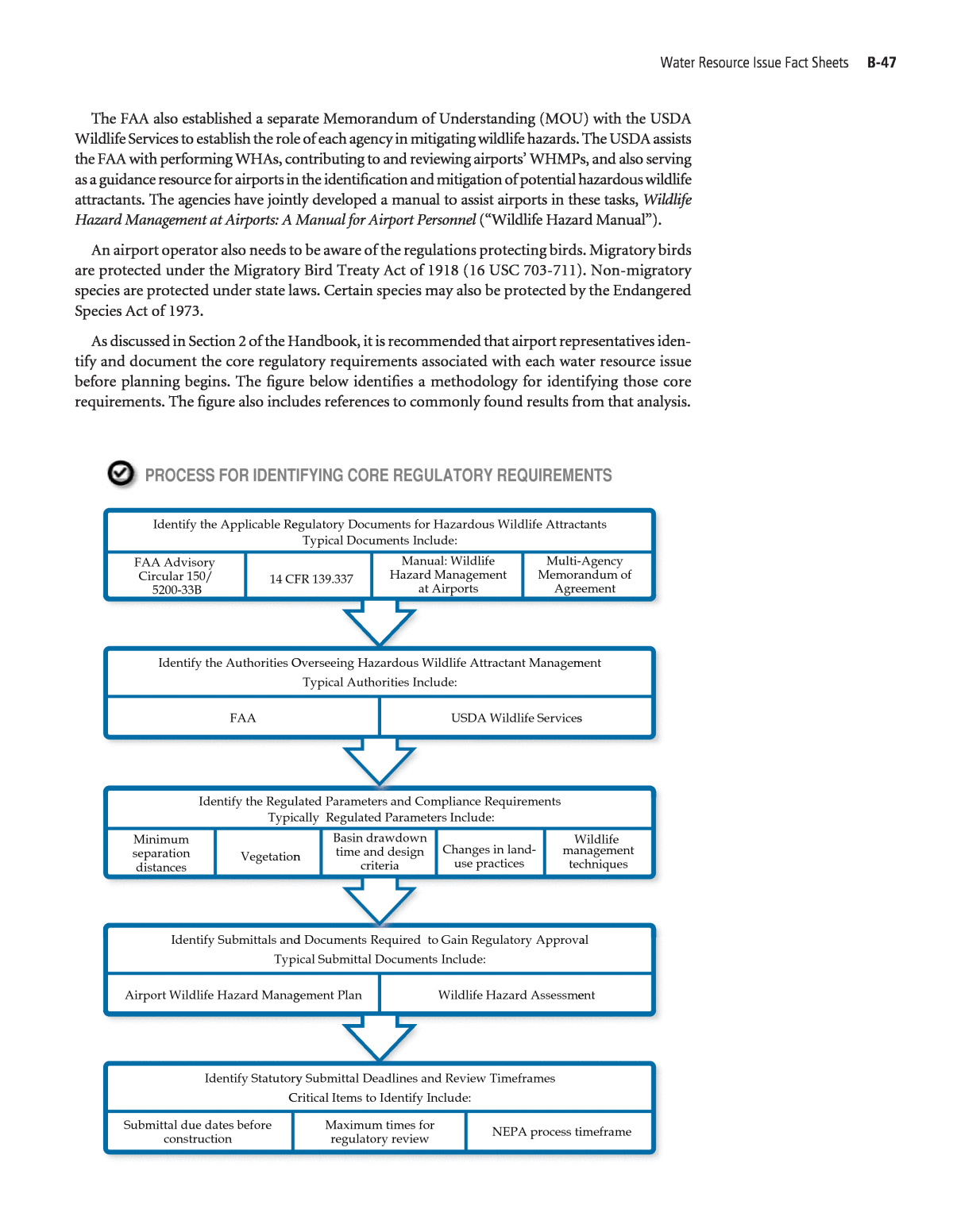


Below is the uncorrected machine-read text of this chapter, intended to provide our own search engines and external engines with highly rich, chapter-representative searchable text of each book. Because it is UNCORRECTED material, please consider the following text as a useful but insufficient proxy for the authoritative book pages.
Contents B-2 Fact Sheet 1: Physical Impacts to Wetlands and Other Surface Waters B-12 Fact Sheet 2: Surface Water and Groundwater Quality B-30 Fact Sheet 3: Storm Water Quantity and Floodplains B-44 Fact Sheet 4: Hazardous Wildlife Attractants B-54 Fact Sheet 5: Aquatic Life and Habitat B-64 Fact Sheet 6: Coastal Zones and Barriers B-73 Fact Sheet 7: Wild and Scenic Rivers B-82 References for Appendix B B-1 A P P E N D I X B Water Resource Issue Fact Sheets
The water resource issue category âPhysical Impacts to Wetlands and Other Surface Watersâ encompasses the impacts of airport development projects on the physical characteristics of sur- face waters, including wetlands, and the associated permitting requirements. This fact sheet pres- ents guidance on planning for and managing the issues associated with physical impacts to wet- lands and other surface waters for airport development projects. 1.0 Description of Water Resource Issue and Impacts Airport property may contain, or be adjacent to, wetlands or other surface waters such as streams, rivers, surface drainage ditches, or ponds. The infrastructure siting associated with new development projects often results in potential physical impacts to these resources, as well as to buffer zones surrounding the resources. Avoidance of these impacts is the top priority. Often in cases with limited available land, avoiding impacts is incompatible with the project function. Where impacts appear unavoidable, permits and mitigation measures are required. Unauthorized impacts to these resources could impact stream quality, water quality, biodiversity and biotic habi- tat, etc. or result in changes in wetland acreages, or runoff and floodplain characteristics. Information on related water resource issues can be found in other fact sheets, as indicated below. B-2 Fact Sheet 1 Physical Impacts to Wetlands and Other Surface Waters RELATED WATER RESOURCE ISSUES Water Resource Issue Relationship Storm Water Quantity and Floodplains Surface Water and Groundwater Quality Hazardous Wildlife Attractants Coordinate on the construction of structures within or over surface waters; stream excavation, dredging, or channelizing; and filling within wetland areas. Coordinate on the construction of structures within or over surface waters; stream excavation, dredging, or channelizing; and filling within wetland areas. Coordinate on stream excavation, dredging, or channelizing, as well as wetland or surface water mitigation locations and design criteria.
2.0 Identification of Core Regulatory Requirements Regulations have been developed at various governmental levels to address the potential effects of physical impacts to wetlands and other surface waters from development projects to protect these resources and biotic habitats. Section 2 of this fact sheet provides the following: ⢠A summary of the surface water and wetland regulations associated with physical impacts typ- ically applicable to airports ⢠A methodology for identifying the core regulatory requirements generally applicable to each airport locale The discussion below focuses on federal regulations; check Chapters 20 and 21 of the FAA Desk Reference and with local agencies to determine if additional requirements may apply. 2.1 Summary of Core Regulatory Requirements Federal rules for physical impacts to wetlands and other surface water resources date back to 1899 under the Rivers and Harbors Act, and were primarily derived to support commerce and agricultural development. The rules focused on large rivers and streams considered ânavigable waters of the United States.â Sections 9 and 10 of the Rivers and Harbors Act established a per- mit program for structures affecting or work conducted in navigable waters. Section 404 of the Clean Water Act (CWA) established a permitting program under United States Environmental Protection Agency (USEPA) guidance for discharges of dredge or fill materi- als into âwaters of the United States.â If structures, work, or discharges of material are proposed for surface waters, including wetlands, a permit authorizing the activity may be required by the USACE before the activities commence. Permits may cover projects pursuant to both the Rivers and Harbors Act and the CWA. The permitting program is regulated under 33 Code of Federal Regulations (CFR) 320-330 and permit issuance may be as a general or individual permit. General permits, or Nationwide Permits (NWPs), cover many similar types of activities or have limited thresholds for surface water length or wetland acreage impacts. Individual permits cover activity-specific projects or when threshold conditions listed for general permits are exceeded. Prior to authorization of a Section 9, 10, or 404 permit, a Water Quality Certification under Section 401 of the CWA must be issued by the state to certify that the federal permit meets state water quality standards. Authorization may include region-specific conditions. Consultation must also take place with the United States Fish and Wildlife Service (USFWS) and other state agencies under the Fish and Wildlife Coordination Act (FWCA) when a project requiring a fed- eral permit has the potential to affect fish and wildlife. Water Resource Issue Fact Sheets B-3 Water Resource Issue Relationship Coastal Zones and Barriers Aquatic Life and Habitat Coordinate on the construction of structures within or over surface waters; excavation, dredging, or channelizing; and any filling within wetland areas. Coordinate on physical impacts to surface waters that may be associated with loss of habitat for biotic resources.
Actions that physically impact surface waters in coastal areas may be subject to the Coastal Zone Management Act of 1972 (CZMA), as amended by the Coastal Zone Management Reauthoriza- tion Amendments of 1990 (23 CFR 650.211) and the Coastal Zone Protection Act of 1996, and Coastal Barrier Resources Act of 1982 (CBRA), as amended by the Coastal Barrier Improvement Act of 1990. Actions that impact essential fish habitat (e.g., estuaries, coral reef, and inter-coastal areas) are also subject to MagnusonâStevens Fishery Conservation and Management Act of 1976 (MSFCMA), under the authority of the National Marine Fisheries Service (NMFS). Refer to the Coastal Zones and Barriers Fact Sheet for further information on impacts to coastal resources. Since federal agencies authorize Section 9, 10, and 404 permits, the requirements of NEPA apply. Typically, the United States Army Corps of Engineers (USACE) ensures NEPA requirements are met through the agencyâs internal permit approval process. However, in some situations other federal agencies, such as the Federal Aviation Administration (FAA) may decide to be the lead reg- ulatory agency for the NEPA process. Water quality based impacts to wetlands and other surface waters are covered by regulations other than those described above. Those issues are discussed in Fact Sheet 2 Surface Water and Groundwater Quality. As discussed in Section 2 of the Handbook, it is recommended that airport representatives iden- tify and document the core regulatory requirements associated with each water resource issue before planning begins. The figure below identifies a methodology for identifying those core requirements. The figure also includes references to commonly found results from that analysis. B-4 A Handbook for Addressing Water Resource Issues Affecting Airport Development Planning TIPS FOR . . . Identifying Core Regulatory Requirements ⢠Assess whether multiple entities have jurisdiction and seek guidance on over- lapping and conflicting requirements. ⢠Coordinate with regulators in assessing whether general or individual permits and certifications for typical development projects are applicable to different types of airport development projects. ⢠Coordinate with regulators to clarify the timing of submittal requirements with respect to the design and construction processes. ⢠Coordinate with regulators and review regulatory guidance to determine the specific regulatory submittal requirements for the permit application process, including report documentation, calculations, and site plans. ⢠Identify mitigation ratios for surface water or wetland impacts. 3.0 Determination of Measures Needed for Compliance Section 3 of this fact sheet presents a methodology for determining the means of achieving compliance that is specific to each project. 3.1 Characterize Physical Impacts to Wetlands and Other Surface Waters Characterizing the unavoidable effects of a development project on surface waters and wet- lands requires an understanding of how the project affects the development site and an under-
standing of the core regulatory requirements. Not all impacts to wetlands and other surface waters require a federal permit. The USACE determines if it has jurisdiction over a wetland or other surface water based on a site-specific analysis to determine if there is a significant ânexus,â or connection, with traditional navigable water. Prior to determining if a federal per- mit is needed, it is important to confirm if the wetland or surface water is under the jurisdiction of the USACE. Those resources not covered under the USACEâs jurisdiction include those that are not hydraulically connected to a navigable water. An example of a non-hydraulically con- nected surface water is an isolated wetland. Typically, impacts to these types of surface waters are authorized by state agencies. If the wetland or surface water is under the USACEâs jurisdiction, site-specific information must be obtained pertaining to the surface waterâs characteristics and how unavoidable actions Water Resource Issue Fact Sheets B-5 PROCESS FOR IDENTIFYING CORE REGULATORY REQUIREMENTS Identify Statutory Submittal Deadlines and Review Timeframes Times permits are valid after approval Submittal due dates before construction Identify Submittals and Documents Required to Gain Regulatory Approval Typical Submittal Documents Include: Jurisdictional determination Identify the Regulated Parameters and Compliance Requirements Typically Regulated Parameters Include: Construction of a structure(s) within a surface water Filling, draining, channelizing, dredging, or excavating Identify the Authorities Overseeing Physical Impacts to Surface Waters and Wetlands State agencies Identify the Applicable Regulatory Documents for Physical Impacts to Surface Waters and Wetlands Rivers and Harbors Act, Sections 9, 10 CWA Sections 401, 404 Critical Items to Identify Include: Maximum times for regulatory review Public comment periods Pre-construction notification Permit application Performing activities that change the water table of a surface water Actions that result in indirect effects to a surface water Typical Authorities Include: USACE USFWS Typical Documents Include: Executive Order 11990 FWCA
will physically impact the resource. Once the level of impacts is determined, the airport can iden- tify if the action qualifies for a NWP or individual permit. Refer to Section 3.3 for information on avoiding/minimizing impacts. Additional information, such as cultural and biotic resources, and mitigation should be incorporated in applications. In the event a project must be located in jurisdictional waters, the project footprint should be overlaid on a map of characterized wetlands and other surface waters to assess the potential impacts to the water resource. At conceptual planning stages an approximate acreage, or lineal feet, of impacts is suitable in most cases. Prior to submitting permit applications, more specific bound- aries defined by geographic coordinates are usually necessary. The potentially impacted wetland acreage or stream length may need to be categorized by the quality of the impacted surface water. 3.2 Compare Project Effects to Regulatory Conditions If surface waters are under the jurisdiction of the USACE, a permit may be needed prior to development. A review should be conducted for the proposed action, associated federal and regional permit conditions, and Section 401 Water Quality Certification requirements. If the review results in identifying impacts that are below regulatory thresholds, a permit is typically not required. If impacts are above regulatory thresholds, the review should help identify the type of permit needed for the project. Thresholds for wetlands are typically in terms of acres of wetlands that are impacted. Thresholds for streams and other navigable waters are typically in terms of lineal feet of the surface water that are impacted. It is important to note that although a permit from USACE may not be needed, a Water Quality Certification may still be required. Regulatory conditions for impacts to biotic and cultural resources must also be evaluated. Depending on the type of biotic community or cultural resources present, regulatory require- ments may necessitate the need for additional documentation or approvals prior to development. 3.3 Identify Required Controls and Modifications to Development Project Federal agencies must evaluate the project and options to avoid or minimize impacts to wet- lands and other surface waters. This requires airport operators to determine if the project can be relocated elsewhere to avoid physical impacts to wetlands and other surface waters. The review may result in the airport no longer needing a permit or other approvals for the project. If the project cannot be relocated, the airport must identify alternatives to minimize impacts. Mitigation is required as a condition for some permit authorizations. It is important that the type of wetland or other surface water is adequately characterized so that impacts requiring mit- igation are sufficiently identified. Impacts can be mitigated on or offsite. If impacts are planned to be mitigated offsite, typically a mitigation ratio is implemented. Mitigation acreages for wet- lands or length of stream impacts may need to be calculated. For example, if 5 acres of wetlands are filled at the airport, the authorizing agency may require 10 acres of wetlands to be mitigated offsite (2:1 mitigation ratio). 3.4 Prepare and Submit Compliance Documents Documentation requirements for permit approval depend on if the permit is a NWP or indi- vidual permit. In some cases, activities authorized by NWP may proceed without notifying the USACE. However, some NWP require advanced notification of the action and a pre-construction notification (PCN) must be sent to the USACE and state agency. Each NWP specifies the docu- mentation needed for the PCN. B-6 A Handbook for Addressing Water Resource Issues Affecting Airport Development Planning
Water Resource Issue Fact Sheets B-7 Recommended Steps for Characterizing Physical Impacts to Wetlands and Other Surface Waters Collect Determin Collect data require Obtain informatio If wetlands or other surface wate or state agency Submit delineati Characterize surface waters or w Review NW Acqui Determine if surface waters or w and analyze additional information e need for additional data collection d for a Section 401 Water Quality Certification n pertaining to culturally significant resources rs are under the USACEâs jurisdiction, consult with for potential impacts to biotic communities on for a USACE jurisdictional determination etlands (e.g., quality, type, composition, acreage, len delineate boundaries I Maps online and state agency websites re existing sources of information etlands are located on project property or within the USFWS gth) and vicinity Individual permits require submittal of an application and associated documentation, which is reviewed by the USACE. The following information includes the documentation needed for individual permit applications: ⢠Completed and signed application form ⢠Project description ⢠Site plan ⢠Length of surface water impacts or acreage of wetland impacts ⢠Types and volumes of materials to be dredged or filled ⢠Method of dredging/filling and disposal methods ⢠Early agency correspondence ⢠Jurisdictional determination documentation and approval ⢠Avoidance or minimization of project impacts ⢠Options to meet mitigation requirements A separate 401 Water Quality Certification may be required prior to NWP or individual per- mit approvals. Because state requirements for authorization under a 401 Water Quality Certifi- cation are varied, consult with your state agency to determine specific requirements pertaining to the approval process.
B-8 A Handbook for Addressing Water Resource Issues Affecting Airport Development Planning TIPS FOR . . . Determining the Measures Needed to Achieve Compliance ⢠Acquire information on wetlands and other surface waters within the airportâs boundaries from state agencies and the USACE. ⢠Include wetlands and other surface waters as part of an airport-wide Water Resource Inventory, and create a map of those within the airportâs boundaries. ⢠As a means of reducing risk and balancing cost, prioritize which water resources should receive site-specific delineations and quality assessments in early planning by considering: â Project sites most likely to be used â Project sites that have the highest quality and extent of wetlands and other surface waters. ⢠In early planning, consider that âsupportâ systems for the development project such as detention basins, treatment plants, or roads might themselves potentially lead to physical impacts. ⢠Adequately delineate stream and wetland boundaries to avoid impacting these resources without regulatory approval. Failing to get approval prior to impacts could result in fines or cease-and-desist orders, ultimately impacting project schedule and costs. ⢠Hold a pre-application meeting with regulators to help identify permit type and documentation needs, and actively engage them throughout the permit process. ⢠Ensure that application forms and supplementary documentation are complete when submitted and are received by the authorizing agency. This will help reduce delays due to missing information. ⢠Watch for changes to the project during its planning and design that might change the circumstances and conditions for regulatory actions, resulting in the need to reassess compliance status. Coordinate with regulatory agencies when preparing applications to obtain a common understanding of âcomplete.â ⢠Review permit conditions and conduct work as specified in permit authorization, including standard conditions in NWP. Follow-up with any required documents, actions, inspections, etc. ⢠Determine if this water resource issue requires coordination with multiple regu- latory agencies. There is sometimes significant political and community input to impacts associated with particular high-value resources, especially in coastal areas, which can cause significant delays in the NEPA process. If airports are aware of potentially significant public interest that may benefit by eliminating project alternatives that are unlikely to be approved. ⢠Identify agencies or public groups with special interests that may be involved with the approval process. ⢠Verify that potential mitigation options, including mitigation banks, are approved for such a use. ⢠Assess whether the process of complying with applicable regulations requires modification to existing permits or Storm Water Pollution Prevention Plans (SWPPPs).
4.0 Reduction of Water Resource Issue Effects on Development Projects Section 4 of this fact sheet identifies the ways in which planning and management of physical impacts to wetlands and other surface waters can affect development project and project planning. 4.1 Siting and Construction of Development Project Planning considerations for reducing the effect of compliance with regulations associated with this water resource issue on the development project features and mitigation measures are pro- vided below. ⢠Relocation of some, or all, of the project to avoid wetland or surface water impacts must be considered to meet regulations and/or as a result of significant public input. If alternative sites would not meet project needs, explain why impacts to wetland or waters are unavoidable. ⢠In some cases, portions of a project may need revision of project function or scope to avoid or minimize wetland or surface water impacts. Flexibility of development project features and characteristics will allow for more opportunities to adapt to regulatory constraints as they arise. ⢠When assessing sites in early project planning phases, the presence of wetlands, especially high quality wetlands, should be a significant factor in the decision-making matrix. ⢠If multiple projects are foreseen that may impact surface waters or wetlands, use of offsite mit- igation banks owned by a third party or design and construction of an airportâs own offsite wetland or surface water mitigation project should be considered to minimize the cost and schedule implication associated with project-by-project mitigation. ⢠Airport operators will need to coordinate with regulatory agencies regarding a potential need to mitigate within the same watershed as the impact, as well as consider the potential for haz- ardous wildlife attractants associated with mitigation near the airport. 4.2 Airport Operations Achieving compliance with regulations associated with physical impacts to wetlands and other surface waters is typically less influenced by post-construction airport operations than other water resource categories. Methods for reducing operational impacts associated with the inte- gration of the development project planning with surface water and wetland compliance plan- ning are provided below. ⢠Use of onsite mitigation for wetlands and other surface waters is frequently preferred by envi- ronmental regulators, but is a significant concern for airports because of the potential wildlife attractant threat. The airportâs policies and position on wildlife attractants and those of the FAA (as noted in FAA AC 150/5200-33B (9) and the Memorandum of Agreement dated July 2003 (36)) should be clearly presented to the regulatory authority governing the mitigation decision. ⢠The need to move or modify a development project can result in the desired operational lev- els not being reached. ⢠The need for monitoring and maintenance of surface water and wetland mitigation sites fol- lowing construction can add fairly significant costs and should be a consideration in assessing total project costs. 4.3 Schedule and Sequencing The process for assessing, demonstrating, and implementing compliance measures for phys- ical impacts to wetlands and other surface waters can be lengthy and integrally related to the planning, permitting, design, and construction of the development project itself. Items that typ- ically have the most significant impact on schedule are shown in the table below. Water Resource Issue Fact Sheets B-9
The sequencing of these activities in relation to the development project is critical. Failure to adequately identify and collect the data needed for permit applications can be a significant set- back in the ability to stay on schedule. Failure to integrate the permitting, design, and construc- tion schedules for the controls with the permitting, design, and construction schedule for the development project can have cascading impacts on schedule as well. In most cases, the process for acquiring permits and approvals will overlap to some degree with the implementation of compliance measures and the overall development project imple- mentation process. It is important to acquire project-specific schedule information from regu- lators, environmental compliance staff and consultants, design engineers and construction per- sonnel to prepare an overall schedule that effectively integrates and sequences the project steps. For complex projects, the process for obtaining permits can be a multi-year process. Gener- ally, the following approval process is conducted for NWP requiring PCNs: ⢠Prepare and submit PCN. ⢠USACE 30-day review period. ⢠Perform activity after 30-day review period or unless otherwise notified by the USACE. Generally, the following approval process is conducted for individual permit applications: ⢠Prepare and submit permit application form. ⢠USACE application completeness review. ⢠Public notice within 15 days of receipt of a complete application. ⢠15-30 day comment period. ⢠Public comments submitted to applicant. ⢠Applicant submits response to comments within 30 days. ⢠USACE receives Water Quality Certification from state agency. ⢠Permit issued or denied within 60 days of receipt of complete application. Generally, the following approval process is conducted for Section 401 Water Quality Certi- fications: ⢠Prepare and submit certification application. ⢠State agency completeness review. ⢠USACE coordinates with state agency. ⢠State agency issues 401 Water Quality Certification. ⢠Permit issued or denied by USACE. 4.4 Project Costs It is important to account for costs associated with data collection needs, agency negotiations, or mitigation associated with the compliance process. To minimize costs, it is recommended that airport operators identify any surface waters or wetlands in the vicinity of the airport during the Conceptual Planning Phase or even before development is conceived, as part of a site-wide inven- tory or broader Water Resource Inventory. The knowledge gained from this effort can help to inform decisions about project siting when development projects are in the early planning phases. Coordination should begin with potential regulatory agencies as soon as the project team is aware that there may be potential impacts for a particular project and some level of definition can be provided to potential impacts. This may begin as early as the Conceptual Planning Phase. Agency discussion or review can take up to several months to complete to ensure project goals are met and the authorizing agency is satisfied with the project design. Consultation with the agencies can also help to minimize impacts to surface waters and wetlands. When it comes to avoiding, minimizing, or mitigating for potential impacts, it is important for airport operators to consider all the options available to them, including combinations of B-10 A Handbook for Addressing Water Resource Issues Affecting Airport Development Planning
Water Resource Issue Fact Sheets B-11 GUIDANCE FOR . . . Reducing Potential Cost and Schedule Impacts Item Factors that Can Reduce Cost and Shorten Schedule Water Resources Inventory Permit Acquisition and Approval Design Development Development Revenue Schedule and Sequencing Staffing Stakeholder Coordination Delineation Documentation Mitigation Start of Work Prepare water resources inventory for use on multi- ple projects. Limit impacts if possible to utilize NWPs rather than individual permits where applicable to minimize schedule and reduce preparation costs. Provide alternatives that avoid or minimize impacts to surface waters or wetlands and design projects that do not incorporate unique engineering or construction practices. Account for gained or lost revenue (e.g., parking) from changes if project function or scope must change to achieve compliance. Recognize that schedule changes usually equate to cost increases for consultation, design, and construction. Identify the expertise needed, select qualified experts, and bring them in at the right time to avoid re-doing work. Seek to understand cost considerations raised by stakeholders such as airlines and various airport departments. Coordinate early with stakeholders such as airlines, regulators, various airport depart- ments, and communities to avoid multiple itera- tions of permitting and design. Plan for early and ongoing coordination with regulators (pre- application meeting). Adequately delineate stream and wetland bound- aries using required methods, preferably with an airport wide delineation to reduce time commit- ments on individual projects. Submit complete notifications and applications. Consider enhancements to existing wetlands or sur- face waters to get mitigation credit rather than construction of new wetlands or surface water segments. Be sure the mitigation does not affect aviation safety. Verify that federal agencies have fully completed activities and issued permits and approval before construction. project modifications and on or off-site mitigation, to identify the solution that might be most cost-effective for their particular application. Mitigation requirements for project impacts can also be very costly, especially if mitigation is conducted offsite at a regulator-approved mitiga- tion bank.
The water resource issue category âSurface Water and Groundwater Qualityâ encompasses the impacts of airport development projects on the quality of surface waters and groundwater. Although surface waters and groundwater can be considered differently in a regulatory context, they share similarities from a development project perspective and are therefore considered jointly in this fact sheet. This fact sheet presents guidance on planning for and managing surface water and groundwater quality issues associated with airport development projects. 1.0 Description of Water Resource Issue and Impacts 1.1 Overview of Surface Water Quality Surface water can include streams, rivers, lakes, wetlands, harbors, territorial seas, waters of the contiguous zone, and oceans. âSurface water,â as a regulatory term, may have varying inter- pretations and has the potential to be confused with terms such as âwaters of the United States,â âwaters of the state,â or ânavigable waters.â Court rulings have clarified these distinctions to some degree. Surface water quality is a broad term that is associated with maintaining the beneficial use of surface waters as it relates to pollutant levels and their effects. A variety of narrative and numeric measures have been developed to classify beneficial use designations and surface water quality standards. A central aspect of managing surface water quality issues is that it is primarily a local issue, meaning that specific characteristics and regulatory designations of individual surface waters have a significant impact on the challenges and means for compliance with regulations. In general, airport development projects, such as deicing pads, deicer application areas, or fuel- ing areas, can affect surface water quality as a result of changes in characteristics affecting storm water, pollutants associated with changes in operations, or construction activities. Therefore, both construction and post-construction operations need to be considered when managing surface water quality issues during development project planning. Construction-related issues are often associated with sediment management (dissolved and total solids) and erosion control, but also include fuel and petroleum management to prevent spills. Post-construction operational issues can be associated with new or additional material handling in the developed areas, changes in storm water quantities that change pollutant concentrations or loading rates in nearby surface waters, and changes in the locations to which pollutants are discharged to the receiving waters. Pollutants contained in storm water and process water discharged during construction or operations have the potential to affect human health, aquatic life, aquatic habitat, and other des- ignated uses of the receiving waters. The characteristics of the receiving waters, their regulatory status, and the water quality criteria defining compliance all affect the relative significance of the surface water quality issue that is encountered. B-12 Fact Sheet 2 Surface Water and Groundwater Quality
1.2 Overview of Groundwater Quality Groundwater is a natural resource that is relied upon as a source of drinking water for the vast majority of rural communities and approximately half of the population in the United States (1). It also serves as a water supply for a large number of industries and agricultural applications. Sup- ply, contamination, and public health are major issues associated with groundwater resources. The public became increasingly aware of the potential for and significance of groundwater con- tamination in the 1970s and 1980s, as over 200 different chemical contaminants were identified in groundwater resources. Above ground and underground contamination sources can impact groundwater quality. Con- taminants on the surface may mix with surface runoff and enter groundwater by percolation through soil, infiltration in aquifer recharge areas and outcroppings, and fissures or cracks in the ground or along well casings. Underground sources of contamination may directly enter an aquifer or may permeate through the soils before entering the groundwater source. Once within an aquifer, the contaminants may form a plume, which may or may not migrate downstream with ground- water flows. The migration of the plume will depend on the amount, type, density, and solubility of the contaminant, as well as groundwater flow characteristics. Contaminated groundwater resources have the potential to also contaminate downstream surface water resources, leading to potential ecological impacts. Potential airport development sources above ground that may impact groundwater are pri- marily associated with airport operations, including deicing and anti-icing, maintenance, chem- ical storage and handling, and pesticide and herbicide application. Other potential sources of groundwater contamination include construction activities, spills and emergency releases of haz- ardous substances, leaking storage tanks or surface impoundments, agricultural activities, waste disposal sites, leaking sewers and septic tanks, leach fields, underdrains, and underground injec- tion wells or infiltration galleries for storm water runoff or other fluids. Information on related water resource issues can be found in other fact sheets, as indicated below. Water Resource Issue Fact Sheets B-13 RELATED WATER RESOURCE ISSUES Water Resource Issue Relationship Wild and Scenic Rivers Physical Impacts to Wetlands and Other Surface Waters Storm Water Quantity and Floodplains Coastal Zones and Barriers Wild and Scenic Rivers regulations encompass protec- tion of surface water quality in rivers carrying those designations. Coordinate on physical impacts such as dredge and fill potentially impacting groundwater. Coordinate on state and local regulatory requirements for these impacts. Changes in storm water quantities from development areas during and after construction can change pollutant concentrations and loads, even if no new pollutant source exists. Coordinate on storm water controls with infiltration components. Coordinate on coastal aquifers and salt water intrusionârelated issues.
2.0 Identification of Core Regulatory Requirements Regulations have been developed at various governmental levels to address the potential effects of changes to surface water and groundwater quality from development projects. Section 2 of this factsheet provides the following: ⢠A summary of the principal surface water and groundwater quality regulations typically appli- cable to airports. ⢠A methodology for identifying the core regulatory requirements applicable to each airport locale. 2.1 Summary of Surface Water Quality Core Regulatory Requirements Water quality regulations are typically designed to reduce or eliminate the discharge of pollutants and to protect beneficial uses of receiving waters such as water supply, recreation, aquatic life, and agriculture. Surface water quality is governed primarily through the Clean Water Act (CWA) and a number of federal regulations designed to implement the CWA for specific water quality issues and situations. The CWA is the principal federal law governing water pollution. It pro- hibits discharge of pollutants from point sources to waters of the United States without a per- mit. Regulated discharges under the CWA include direct discharges to waters of the United States. Discharges to municipal separate storm sewers that have a direct connection to waters of the United States may also be regulated under the CWA. Of particular historical interest to air- ports is the fact that storm water discharges were not specifically addressed under CWA until the Water Quality Act of 1987. The CWA includes six titles. Three of the titles have particular importance to a high level understanding of the CWA provisions for airports. 2.1.1 Title IIIâStandards and Enforcement ⢠Requires discharge permits ⢠Establishes technology-based standards program ⢠Establishes water quality-based standards program ⢠Establishes authority for the United States Environmental Protection Agency (USEPA) to issue administrative orders against violators and seek civil or criminal penalties 2.1.2 Title IVâPermits and Licenses 2.1.2.1 Section 401âWater Quality Certification ⢠Section 401 requires a water quality certification from the USEPA or designated states before issuance of a federal permit to ensure that the proposed discharge is consistent with the CWA. 2.1.2.2 Section 402âNPDES Program ⢠National Pollutant Discharge Elimination System (NPDES) permits must be obtained for con- struction projects affecting one or more acres or part of a larger common plan of development, and for airports with industrial storm water discharges associated with material storage, fueling, deicing, and maintenance. ⢠Facilities either apply for an individual NPDES permit or for coverage under a general permit if their operations or discharges fall under an available general permit. ⢠NPDES permits may include numeric limitations, narrative requirements, as well as allowances or requirements for Best Management Practices for controlling pollutant loads, often specified in Storm Water Pollution Prevention Plans (SWPPPs.) ⢠USEPA has delegated authority to implement the NDPES program in most states. Regional USEPA offices implement the program in the remaining states. 2.1.2.3 Section 403âOcean Discharge Criteria ⢠Regulates discharges to territorial sea, waters of the contiguous zone, and oceans and includes protection of human health and welfare as well as marine life B-14 A Handbook for Addressing Water Resource Issues Affecting Airport Development Planning
2.1.2.4 Section 404âPlacement of Dredge and Fill Materials ⢠Regulates placement of dredged or fill materials in waters of the United States (see Fact Sheet Physical Impacts to Surface Waters and Wetlands for additional description of Section 404). Several other laws govern surface water quality-related issues, including: 2.1.3 Safe Drinking Water Actâ42 United States Code (U.S.C.) 300f ⢠Established to protect drinking water by regulating surface water and groundwater drinking water sources ⢠Prohibits the use of federal financial assistance for a project that would contaminate the recharge zone for a sole source aquifer 2.1.4 Oil Pollution Act of 1990â33 U.S.C. 2702 (OPA) The Oil Pollution Control Act is an amendment to the CWA designed to prevent and respond to oil spills. As regulated under 40 CFR 112, the OPA includes the following requirements impor- tant to airports: ⢠Applies if a facility has an oil storage capacity that exceeds 42,000-gallons of underground stor- age capacity, or 1,320-gallons of above ground storage capacity. ⢠Includes oil stored in tanks, drums, mobile refuelers, oil-filled transformers, hydraulic oil reservoirs for elevators. ⢠Excludes permanently closed tanks, motive power tanks (tanks on vehicles and aircraft), under- ground storage tanks (USTs) regulated by Part 280 or a Part 280 state programs, and containers less than 55 gallons. ⢠Requirements of this regulation that may affect airport development include: â Develop and implement an SPCC Plan â Provide sized secondary containment for oil storage containers â Provide general secondary containment â Requirements for new USTs, and upgrades to existing USTs ⢠If an airport stores over 1,000,000 gallons of oil, it may be required to develop a Facility Response Plan (FRP). Discharges from airports to surface waters potentially are covered under several aspects of CWA and associated regulations, including: ⢠Storm water discharges from areas of industrial activity for airports covered under Standard Industrial Classification (SIC) code 45. ⢠Storm water discharges into municipal separate storm sewer systems (MS4s) whose discharges are regulated under the CWA. ⢠Storm water discharges from areas of construction activity disturbing one or more acres of land. ⢠Discharges to Publically Owned Treatment Works (POTW), whose discharges are regulated under the CWA. ⢠Effluent Limit Guidelines (ELG), which are nationally applicable standards for surface water dis- charges for certain categories of discharges. For example, airports with development projects that disturb 10 or more acres are subject to numeric discharge limits under the Construction and Development Category. 2.2 Summary of Groundwater Quality Core Regulatory Requirements Federal regulation of groundwater quality primarily originated with the CWA. The CWA regu- lates groundwater that is connected to surface water. Section 102 of the CWA calls for comprehen- sive programs to be developed at federal, state, and local levels to reduce, eliminate, and prevent groundwater contamination. Many states have provisions for groundwater protection, which may include areas tributary to aquifer recharge areas. The NPDES program, which requires permits for discharges to surface water, includes discharges with the potential to impact groundwater. Other Water Resource Issue Fact Sheets B-15
groundwater provisions in the CWA include dredge and fill operations and water quality criteria that limit particular land uses and development (2). The Safe Drinking Water Act of 1974 (SDWA), as amended in 1986 and 1996, further protects groundwater used as an Underground Source of Drinking Water (USDW). The SDWA authorized the EPA to ensure that drinking water sources are safe for human consumption. The SDWA led the EPA to establish Maximum Contaminant Levels (MCLs), or maximum concentra- tions of contaminants in drinking water supplies, and several programs for protecting USDWs: ⢠Wellhead Protection Program (WHP): requires states to develop their own WHP, as well as estab- lish protection areas around wells to minimize the potential for contamination of USDWs (1). ⢠Sole Source Aquifer (SSA) Program: prohibits federal funds from being used on a project that may contaminate a sole or principle USDW for an area, or its recharge area (3). This program allows for the establishment of Critical Aquifer Protection Areas (CAPAs) (1). ⢠Underground Injection Control (UIC) Program: permit program that regulates the design, operation, inspection, and monitoring of five classes of injection wells used to store or dispose of fluids underground to protect USDWs. Hazardous waste injection requires coordination under RCRA. ⢠Source Water Assessment (SWA) Program: EPA can provide grants to individual states to develop programs for protection of groundwater resources. EPA must report to Congress every three years on the quality of groundwater resources. As the public awareness of the extent of groundwater contamination increased over time, additional regulations were established to focus on the control of sources of contamination, including solid and hazardous waste disposal sites, spills and emergency releases of contami- nants, pesticides and herbicide use, and sanitary waste. Drinking water standards are used to determine groundwater protection requirements under a number of these other statutes. The Resource Conservation and Recovery Act of 1976 (RCRA), an amendment to the Solid Waste Disposal Act (SWDA), as amended in 1996, regulates the treatment, storage, and disposal of hazardous and non-hazardous wastes. It includes provisions for protecting groundwater from contamination due to landfills, USTs, surface impoundments, and hazardous waste facilities. The provisions include monitoring requirements, liners and containment systems, and spill detection systems. The 1984 Hazardous and Solid Waste Amendments to RCRA (HSWA) expanded the RCRA requirements by including requirements for reducing the toxicity of wastes (1). Additional RCRA amendments in 1992 and 1996, respectively, strengthened enforcement authority at federal facilities and provided additional regulatory flexibility for land disposal of wastes. RCRA restric- tions also include the location for waste facilities based on hydrogeological conditions, and correc- tive actions to address significant changes in groundwater quality. The Comprehensive Environmental Response, Compensation, and Liability Act of 1980 (CER- CLA, Superfund) provides a federal âSuperfundâ and authorizes the federal government to clean up contaminated sites, including those with the potential to endanger drinking water supplies. The 1986 Superfund Amendments and Reauthorization Act (SARA) reauthorized CERCLA to con- tinue cleanup activities (4). CERCLA and Superfund are designed to protect human health and the environment, with a major goal being to restore contaminated groundwater to beneficial use and meet drinking water standards where practicable and appropriate (5). Groundwater protection and restoration provisions are included in the monitoring and response activities performed under CERCLA by states. Other federal regulations, including the Federal Insecticide, Fungicide, and Rodenticide Act of 1947 (FIFRA), as amended in 1972, and the Toxic Substances Control Act of 1976 (TSCA), as amended in 2002, provide indirect protection measures through regulation of chemicals with the potential to contaminate groundwater. In 2006, the Ground Water Rule (GWR) was established as part of compliance with the 1996 Amendments to the CWA, and called for regulations for disinfection of groundwater drinking B-16 A Handbook for Addressing Water Resource Issues Affecting Airport Development Planning
water supplies. The objective of the GWR is to reduce public health risk and incidence of disease associated with disease-causing microorganisms in groundwater that is a source of drinking water. The GWR applies to public water systems that serve groundwater and a combination of surface water and untreated groundwater. It does not apply to public water systems that combine groundwater and surface water prior to treatment. As this rule regulates public water supplies, it may not be applicable for new development at airports. Many states, working with local municipalities, have developed or are in the process of devel- oping Comprehensive State Ground Water Protection Programs (CSGWPPs), which may include some or all of the following components: ⢠Groundwater use classification ⢠Localized water quality criteria to supplement federal criteria Water Resource Issue Fact Sheets B-17 PROCESS FOR IDENTIFYING SURFACE WATER QUALITY CORE REGULATORY REQUIREMENTS Identify Statutory Submittal Deadlines and Review Timeframes Times permits are valid after approval Submittal due dates before construction Identify Submittals and Documents Required to Gain Reulatory Approval Typical Submittal Documents Include: Individual or general NPDES permits Antidegradation reports Identify the Regulated Parameters and Compliance Requirements Typically Regulated Parameters Include: Narrative standards Water quality- based numeric standards Identify the Authorities Overseeing Surface Water Quality State agencies Identify the Applicable Regulatory Documents for Surface Water Quality CWA, 40 CFR 122 SDWA Critical Items to Identify Include: Maximum times for regulatory review Public comment periods Effective periods for NPDES Permits from local entities Storm Water Pollution Prevention Plans Permits to install pollution control Technology- based numeric standards Toxicity criteria Biological criteria Typical Authorities Include: USEPA FAA Typical Documents Include: OPA State regulations NPDES permits permits systems Effluent limits
B-18 A Handbook for Addressing Water Resource Issues Affecting Airport Development Planning PROCESS FOR IDENTIFYING GROUNDWATER QUALITY CORE REGULATORY REQUIREMENTS Identify Statuto Times permits are valid after approval Identify Submittals a Ty Monitoring, inspection reports for groundwater wells Permi discharg in Identify the Reg Typ Solid, hazardous, sanitary waste disposal and land application Chemical a pesticide appli storage and di Identify the State agencies Identify the Applica CWA SDWA RCRA ry Submittal Deadlines and Review Timeframes Critical Items to Identify Include: Timeframe for submittal of monitoring and inspection reports Maximum t regulatory nd Documents Required to Gain Regulatory Approv pical Submittal Documents Include: t applications for es or underground jection wells Documents supporting required remediation activities Grou treatm ulated Parameters and Compliance Requirements ically Regulated Parameters Include: nd cation, sposal Industrial discharges (e.g., deicing, maintenance, landscaping) Underground injection of fluids La d Authorities Overseeing Groundwater Quality Typical Authorities Include: EPA United States Geological Survey (USGS) Loca ble Regulatory Documents for Groundwater Qualit Typical Documents Include: TSCA CERCLA SARA FIFRA imes for review al ndwater ent records nd use and evelopment areas l agencies y CSGWPP ⢠Land use management ⢠Funding for implementation of program and cleanup efforts ⢠Requirements for discharge permits and underground injection In addition to the components above, states may be responsible for implementing regulations for USTs and pesticides. As discussed in Section 2 of the Handbook, it is recommended that airport representatives iden- tify and document the core regulatory requirements associated with each water resource issue before planning begins. The preceding figure identifies a methodology for identifying those requirements. The preceding figure also includes references to commonly found results from that analysis.
3.0 Determination of the Measures Needed for Compliance Section 3 of this factsheet presents a methodology for determining the means of achieving compliance that is specific to each project. 3.1 Characterize Project Effects 3.1.1 Surface Water Quality Assessing project-specific surface water quality compliance requirements requires an under- standing of the characteristics of the discharges to surface waters. This characterization can be com- plex because a large number of potential pollutants may be involved and because their character- istics may vary widely. Some discharge characterization data may be available from existing information, such as NPDES Discharge Monitoring Reports. For projects involving changes to pollutant characteristics, collection of additional field data may be required. Collection and assessment of the field data adds costs and increases the time required to execute the project. For certain activities such as deicing, characterization data on discharges can be obtained from calculations or models of the pollutant sources and routing of the pollutants through the storm water drainage system. Water Resource Issue Fact Sheets B-19 TIPS FOR . . . Identifying Core Regulatory Requirements ⢠When assessing the core regulatory requirements for surface water quality that are potentially applicable to your airport, review surface water compliance history at airport, including past NPDES permits, permit applications, SWPPPs, SPCC plans, facility response plans, NPDES discharge monitoring reports, water quality studies, public meeting records, and correspondence with agencies. If the information is not readily available, request the information from your regulator. These documents may contain much of the information needed to document the core requirements. ⢠Use experts with a detailed understanding of surface water and groundwater qual- ity regulations, as well as experience in coordinating with the applicable regulators, to identify or review the core regulatory requirements. ⢠Many state agencies, as well as USEPA, have information available online sum- marizing regulations and their applicability. ⢠Assess whether multiple entities have jurisdiction and seek guidance on overlap- ping and conflicting requirements. ⢠Coordinate with regulatory authorities early and often to identify potential impacts, required permits and approvals, and potential project modifications or mitigation measures. Particularly, coordinate on requirements for compliance with groundwater statutes related to USDWs and source water protection programs, SSAs, WHPs, subsidence due to over-pumping of aquifers, and salt water intrusion. ⢠Acquire information on water quality studies that have been performed in the airportâs watershed, through, for example, a regulatorâs Total Maximum Daily Load (TMDL) program. This information can provide guidance on local water quality issues and future water quality standards. ⢠Seek a clear and common understanding of the meaning and applicability of reg- ulated surface waters with state and local regulators.
3.1.2 Ground Water Quality Characterizing the effects of a development project on groundwater quality requires an under- standing of how the project could affect groundwater and the core regulatory requirements. The location and extent of groundwater resources in the vicinity of the project and airport must be identified to characterize potential project effects. Particular attention should be paid to USDWs and source water protection areas, drinking water supply well locations, sole or principle source aquifers and CAPAs, and delineated recharge areas. Examples of typical information sources needed to identify this information includes: ⢠CSGWPP or other local and state groundwater requirements, including groundwater provi- sions in surface water quality statutes ⢠Project features and land uses that may be regulated and potential threats to groundwater quality ⢠USDWs and protected groundwater features, including wellhead protection areas and sole source aquifers ⢠Site studies and surveys ⢠Regulatory agency documentation and mapping of protected groundwater resources and restricted development areas B-20 A Handbook for Addressing Water Resource Issues Affecting Airport Development Planning Recommended Steps for Characterizing Project Effects on Surface Water Quality Collect and analyze the characterization data for inclusion in NPDES permit applications For new developments or existing developments with new activities, estimate the future pollutant discharges and flow rates Collect additional pollutant concentration and flow data as needed to characterize discharges Review existing data characterizing the pollutant concentrations and flow rates at the discharge Determine the outfall locations for the discharges Identify the pollutants associated with the areas of industrial activity Identify areas on the airport with current and planned regulated industrial activity locations The collected data characterizing storm water discharges is submitted in applications for NPDES permits. It is used in assessing whether the discharges have a reasonable potential to exceed poten- tially applicable effluent limits.
Although the specific requirements will vary from one locality to the next, the project charac- teristics that may impact groundwater quality include: ⢠Land application/runoff from pesticides, herbicides, pavement cleaners, or other exposed or land-applied materials ⢠Aircraft/pavement deicing/anti-icing activities, including application, collection of runoff, and treatment or disposal of runoff ⢠Maintenance activities and potential for spills or emergency releases ⢠Chemical storage, handling, and disposal, including above ground storage tanks (ASTs) and USTs ⢠On-site sanitary waste disposal methods (e.g., septic tanks, leach fields) ⢠Solid and hazardous waste collection and disposal ⢠Project location, footprint, and depth ⢠Soil and drainage characteristics, including general infiltration characteristics, and flow pat- terns and destinations associated with proposed industrial activity locations ⢠Underground injection or shallow disposal wells, including infiltration BMPs for storm water runoff, well casings located near proposed operational areas, or other potential avenues for groundwater contamination due to surface runoff ⢠Runoff controls, collection and treatment systems, pollution prevention BMPs and protocols, leak detection systems, personnel training, and spill response plans ⢠Areas using pervious pavement Water Resource Issue Fact Sheets B-21 Recommended Steps for Characterizing Project Effects on Groundwater Quality Collect Determi Submit required information t Characterize groundwater (e. Determine if groundwater is lo for contaminants from pr Review state and local require groundwater Acqu and analyze additional information ne need for additional data collection o local or state agencies for review (e.g., plans, cal g., source, type, composition, use protection) and boundaries cated near project property, and if there may be a oject area to migrate to nearby groundwater resou ments, including CSGWPP and online resources t locations, regulated land uses, or activities ire existing sources of information culations) delineate potential rces o identify
3.2 Compare Project Effects to Regulatory Conditions 3.2.1 Surface Water Quality Effluent limitations and other conditions associated with discharges are specified in NPDES per- mits. For some development projects, the existing limits and monitoring conditions will be appli- cable and no additional assessment of effluent limits is needed. For other development projects, new limits and monitoring conditions may be required. Typical drivers for new effluent limits and permit conditions include: ⢠New types of materials used in the areas of industrial activity that result in new types of pol- lutants in the discharges to surface waters ⢠Changes in the quantity of existing materials that increase the loading and concentration of existing pollutants in the discharges to surface waters ⢠Changes in flow rates that change the pollutant loadings or concentrations in the discharges to surface waters ⢠New outfalls or outfall locations ⢠Newly applicable regulatory standards triggered by the development or coincident with the development such as anti-degradationâbased restrictions, limitations based on TMDLs, or effluent guidelines Once the potentially applicable effluent limitations or water quality standards have been deter- mined, the project effluent quality is compared to the potentially applicable effluent limitations in what is typically referred to as a reasonable potential analysis. From this analysis, the regula- tory authority determines which pollutants have limitations, the numeric value of those limita- tions, the statistical basis for the limits (e.g., daily maximum, monthly average) and the moni- toring requirements for limited pollutants and non-limited pollutants. 3.2.2 Groundwater Quality Assessing compliance with groundwater quality regulatory conditions will vary somewhat depending on local and state regulations. Airports may need to consider whether proposed proj- ect features or activities are in compliance with groundwater statutes and if controls or modifi- cations are necessary to comply with these statutes. Development projects at airports must also comply with local, state, and federal regulatory conditions associated with planned land uses or project features with the potential to endanger groundwater quality. 3.3 Identify Required Controls and Modifications to Development Project 3.3.1 Surface Water Quality Should the projected effluent quality exceed the effluent limits, or other restricting conditions, mitigation measures may be needed to achieve compliance with the limits. Those measures typ- ically could include: ⢠Reductions in material use ⢠Best management practices to control pollutants near the point of contact with the storm water ⢠Changes to material use areas ⢠Low impact development and other local controls to promote ânaturalâ pollutant degradation or reduction ⢠Discharge of portions of the pollutant-impacted storm water to sanitary sewers ⢠Collection and recycling of materials contributing to pollution prior to discharge ⢠Collection and on-site treatment of pollutant-impacted storm water B-22 A Handbook for Addressing Water Resource Issues Affecting Airport Development Planning
Implementation of the measures can require significant infrastructure, including: ⢠Piping systems ⢠Pump stations ⢠Tanks or basins ⢠Control systems ⢠Treatment systems An airport activity that often requires control measures involving significant infrastructure for many airports is aircraft deicing. Pavement deicing, sediment management, and fuel system man- agement may also require significant infrastructure. Other activities leading to implementation of control measures at airports could include vehicle washing, vehicle parking, pavement clean- ing, chemical storage, and other maintenance activities. 3.3.2 Groundwater Quality Airport operators will need to continue coordination with regulatory authorities to determine the conditions for compliance. Many of the regulatory conditions include controls for ground- water quality protection. For example, projects with proposed USTs will need to comply with applicable state and federal UST regulations. Requirements for CERCLA may apply to inactive or abandoned sites with soil or groundwater contamination and require mitigation for cleanup. It may be necessary to identify and incorporate measures for protecting groundwater quality or for controlling or treating potential sources of contamination prior to development. Modifications may be required to change the project location to avoid impacts to a groundwater resource, or to revise or eliminate particular project activities or migration pathways with the potential to endan- ger groundwater quality. 3.4 Prepare and Submit Compliance Documents 3.4.1 Surface Water Quality Management of surface water quality issues for new or re-development projects involves a series of regulatory documents, some of which are listed below. Check with the regulator to determine which documents require applications or other submittals, and which documents simply need to be maintained on the site for potential review. It is typically the responsibility of the airport operator, or its designated representatives, to prepare these documents. ⢠NPDES permit (application required) ⢠Anti-degradation application and report ⢠Water quality studies for receiving stream ⢠Reports on potential impacts to biology or habitat ⢠Notice of intent for coverage under General Permits ⢠SWPPP for Industry Activity ⢠SWPPP for Construction Activity ⢠SPCC Plan ⢠FRP ⢠Discharge Monitoring Reports ⢠User permit for discharge to sanitary sewer ⢠Permits to Install or construct for water pollution control equipment, possibly including sub- mittal of design or construction documents (application required) ⢠Environmental Impact Statement or Environmental Assessment 3.4.2 Groundwater Quality Specific requirements for documenting and demonstrating compliance will likely vary signif- icantly from one locality to the next, depending on local programs and statutes. Additionally, Water Resource Issue Fact Sheets B-23
potential airport development impacts to groundwater quality are typically evaluated under the National Environmental Policy Act (NEPA). A variety of permits, approvals, and assessments may also be required for proposed land uses and project features that are associated with the potential impacts to groundwater quality (e.g., permits for underground injection wells, sani- tary waste disposal methods, and solid or hazardous waste disposal, submittal of design calcula- tions or construction documents). Whether complying with local statutes or the NEPA process, airports should generally antic- ipate the need to document local groundwater resources, potential sources of groundwater con- tamination, and potential controls and protection measures. B-24 A Handbook for Addressing Water Resource Issues Affecting Airport Development Planning TIPS FOR . . . Determining the Measures Needed to Achieve Compliance ⢠Include surface water and groundwater resources in an airport-wide Water Resource Inventory, and create a map of those within the airportâs boundaries. ⢠Identify protected groundwater resources in the vicinity of the airport. Airport operators should become familiar with the existence of USDWs, including SSAs and WHP areas. ⢠Determine the beneficial uses for all potential receiving waters in the early stages of planning to minimize potential issues with the designated quality (e.g., high quality) of receiving waters. ⢠Determine if new development projects will result in additional pollutant load (e.g., pounds of pollutants per day) to receiving waters or in other changes to the discharge that would trigger compliance with applicable anti-degradation regu- lations. In an anti-degradation review, justifications for changes to the discharge that trigger anti-degradation requirements must be made to the regulatory agency on a social, environmental, and economic basis. The anti-degradation review can lengthen project schedules and could result in the need for additional control infrastructure or development project changes. ⢠Identify surface waters downstream or adjacent to the airport that are fed by groundwater resources to gage cumulative effects of modifications to ground- water. ⢠Consider impacts to water bodies (e.g., lakes, other streams) that have down- stream confluences with airport receiving streams. These may also be affected by airport discharges and can potentially have more stringent water quality stan- dards than the initial receiving waters. ⢠Consider the potential for groundwater impacts associated with the infiltration of storm water runoff potentially containing pollutants. ⢠Manage or contain areas of contaminated groundwater to help prevent down- stream impacts to surface waters. ⢠Take an active role in developing NPDES permit conditions through coordination with the regulatory authority. Effective interaction with the agencies can help improve understanding of the issues and streamline the time to develop permit applications and develop permit conditions. ⢠Recognize that airport discharges can contain limitations derived from a variety of regulatory standards and requirements and that the most stringent limitations apply.
4.0 Reduction of Water Resource Issue Effects on Development Projects Section 4 of this factsheet identifies the ways in which surface water and groundwater quality issue planning and management can affect development project and project planning. 4.1 Siting and Construction of Development Project Planning considerations for reducing the effect of surface water and groundwater quality com- pliance on the development project features and control infrastructure are provided below. Water Resource Issue Fact Sheets B-25 ⢠Review the details of the permit conditions, such as effluent limitations in NPDES permits (e.g., concentration vs. load-based limits, frequency of monitoring, sam- pling type), and conduct work as specified in permit authorization. An understand- ing of these conditions can result in more efficient development and operation of pollution control facilities. Follow-up with any required documents, monitoring, actions, and inspections. ⢠Coordinate on compliance with surface water quality statutes with groundwater provisions, possibly including source water protection under SDWA, as well as NPDES and 401 requirements under CWA. ⢠Assess whether development projects are creating ânew sourcesâ under technology-based regulations. Classification of a project as a new source may trigger more restrictive discharge conditions. ⢠Anticipate the need to consider the location and extent of project features and pro- posed airport operations in relation to the location and extent of groundwater resources. It may be necessary to compare these relative locations to any regulatory separation criteria. ⢠Consider whether changing project criteria, including revisions to project foot- print or location, or controls that meet regulatory criteria is more cost effective than controls for managing ground water quality. ⢠Consider that decisions made on how to manage surface water quality issues can affect groundwater. ⢠Determine whether permits are required to install or construct pollution control equipment. Hold a pre-application meeting with regulators to help identify per- mit type and documentation needs, and actively engage them throughout the permit process. Incomplete application forms or permits not obtained in a timely fashion can delay the start of construction projects. ⢠Verify with regulators that potential mitigation options are available and feasi- ble. Watch for changes to the project during its planning and design that might change the circumstances and conditions for regulatory actions, resulting in the need to reassess compliance status. ⢠Eliminate project alternatives that could result in significant political and com- munity input on impacts, which can cause significant delays in the NEPA process and are unlikely to be approved. ⢠Assess whether the process of complying with applicable regulations requires modification to existing permits or Storm Water Pollution Prevention Plans.
4.1.1 Surface Water Quality ⢠The location of a development project within the airport watershed can impact the degree to which surface water quality management becomes a significant issue. Planning activities with significant pollutant impacts in areas with stringent effluent limitations can threaten the via- bility of the project or lead to significant control systems. Options for modifying the project to avoid this situation should be explored. ⢠Consideration should be given to the location of the development project relative to the location of the water quality controls. Conveying water significant distances to reach pollution control facilities can require compromise in the project layout and disrupt other airport infrastructure. ⢠Pollution control systems for storm water, especially for deicing-driven controls and sediment controls, can require significant amounts of space for storm water storage. These storage needs should be considered early in the project development. Efforts should be made to reduce the volumes of impacted storm water. ⢠The mechanisms needed to manage sediment and prevent erosion should be considered well before construction for large construction projects, especially those covering large lineal areas like runways. In some cases, it may be advantageous to use structures designed for long-term storm water quantity or quality management (i.e., post-construction) for sediment control dur- ing construction. 4.1.2 Groundwater Quality ⢠Use soil probing, sampling, or drilling techniques, and piezometers or wells to characterize groundwater in advance of construction and allow for long-term monitoring of groundwater potentiometric surfaces, flow rates, or groundwater. ⢠Relocation of the entire project, such as a leach field, to avoid groundwater quality impacts may be necessary in some cases if potential impacts to public safety are identified. Having alternate sites for the development project, if feasible, may reduce delays if a change is made. ⢠In some cases, only portions of a project may need revision of project function or scope to avoid or minimize groundwater quality impacts. For example, eliminate planned project fea- tures or land uses that are associated with particular groundwater statutes (e.g., underground injection or land disposal activities). Flexibility of development project design will allow for more opportunities to adapt to regulatory constraints as they arise. ⢠When assessing sites in early project planning phases, the presence of groundwater resources, especially drinking water sources, should be a significant factor in the decision-making matrix. Airports should also identify prohibited land uses, protected resources, and criteria to main- tain minimum horizontal and vertical separation distances surrounding these areas. ⢠Development areas with existing contamination plumes should be avoided. If these sites are necessary for development, mitigation should be conducted and reviewed with regulatory agencies. If it is necessary to pursue development near a potentially contaminated area, coor- dinate with regulatory agencies on options for development that will not exacerbate or may even help to remediate the issue (e.g., use of liners to prevent infiltration of storm water runoff in the area, or implementation of controls). ⢠Modify design of drainage system or utilities (e.g., rerouting of conveyance, use of flow diver- sion techniques, or relocation of outfalls) to prevent potential drainage or leakage to protected groundwater. 4.2 Airport Operations Achieving compliance with surface water and groundwater quality regulations may be inte- grally related to airport operations on the new development and airport operations on existing developments. The operational impacts need to be considered early in the development project implementation process, especially for operations associated with deicing and fueling. Planning B-26 A Handbook for Addressing Water Resource Issues Affecting Airport Development Planning
considerations for reducing the effect of surface water and groundwater quality compliance on the post-development airport operations are provided below. 4.2.1 Surface Water Quality ⢠Most large development projects are based on projected changes in aircraft operations and pas- senger activity many years into the future. The surface water quality analysis, including assess- ment of compliance and control equipment should be considered on a similar timeframe. ⢠Allow all affected stakeholders to provide input on the timeframes and basis for future operational projections affecting surface water quality. ⢠In some cases, it may be significantly advantageous to sacrifice some airport operational objec- tives in exchange for reduced cost, size, and complexity of surface water quality compliance. 4.2.2 Groundwater Quality ⢠The need and costs for monitoring, sampling programs, and maintenance of structural con- trols, collection, and treatment systems following construction during early planning. ⢠Changes to locations and protocols for proposed airport operations (e.g., use of dedicated deicing pad or specialized deicing equipment or techniques) may reduce project impacts and control needs. ⢠Use of best management practices, specialized protocols, and trained personnel to apply, store, handle, and dispose of chemicals and pesticides may reduce project impacts and control needs. 4.3 Schedule and Sequencing 4.3.1 Surface Water Quality The process for assessing, demonstrating, and implementing compliance measures for surface water quality can be lengthy and integrally related to the planning, permitting, design, and con- struction of the development project itself. The sequencing of these activities in relation to the development project is critical. Failure to adequately identify and collect the data needed for calculations and design can be a significant setback in the ability to stay on schedule. Failure to integrate the permitting, design, and con- struction schedules for the controls with the permitting, design, and construction schedule for the development project can have cascading impacts on schedule as well. In most cases, the process for acquiring permits and approvals will overlap to some degree with the implementation of compliance measures and the overall development project imple- mentation process. It is important to acquire project-specific schedule information from regu- lators, environmental compliance staff and consultants, design engineers, and construction per- sonnel to prepare an overall schedule that effectively integrates and sequences the project steps. For complex projects, the process for implementing surface water quality compliance mea- sures can be a multi-year process. 4.3.2 Groundwater Quality The primary schedule components associated with groundwater quality issues include: ⢠Identification of potentially applicable regulations at local, state, and federal levels ⢠Identification of groundwater resources, including restrictions such as protection areas and separation criteria ⢠Regulatory coordination ⢠Identification of controls, modifications, and mitigation measures ⢠Permitting and approvals ⢠NEPA process Water Resource Issue Fact Sheets B-27
Groundwater resources near the airport can be identified well in advance of planning for future development. Airports can become generally familiar with the existence of groundwater protec- tion programs and protocols at local and state regulatory levels, so that they are aware of any poten- tial restrictions on land uses, development, or potential airport operations at the developed site. 4.4 Project Costs Complying with surface water and groundwater quality regulatory requirements can result in significant capital costs associated with the development project as well as long-term costs to the airport once operations on the development areas have begun. 4.4.1 Surface Water Quality Capital costs for the surface water quality controls may not necessarily correspond directly to the capital costs for the development project. Often, the water quality standards associated with the receiving waters and the effluent limits play a significant role in the costs. 4.4.2 Groundwater Quality Major costs associated with groundwater quality regulations generally include the develop- ment of project modifications or controls to minimize impacts, construction controls, permit- ting and regulatory coordination, and the NEPA process. Additionally, once a groundwater sup- ply has become contaminated, it can be very costly and difficult, if not impossible, to return to beneficial use. Contaminated groundwater resources are generally associated with significant costs including cleanup efforts, monitoring, liability issues, public health issues, and the identi- fication and development of alternative water sources. B-28 A Handbook for Addressing Water Resource Issues Affecting Airport Development Planning GUIDANCE FOR . . . Reducing Potential Cost and Schedule Impacts Item Factors that Can Reduce Cost and Shorten Schedule Water Resources Inventory and Data Collection Characterization of Discharges Modeling, Calculations, and Analyses Wasteload Allocation Analysis for Assess- ing Water Quality- Based Effluent Limits Risk Assessments Establish baseline data to use on multiple projects. Include an assessment of surface water and groundwater resources in the water resources inventory. Require detailed field assessments to determine potential project threats to the resources. Obtain buy-in from all stakeholders on the baseline data for future pollutant discharges. Submit modeling plan to regulators for approval in Detailed Planning Phase. Have airport representatives perform the calcula- tions for assessing receiving stream assimilation capacities and allowable effluent limits to submit to regulator for review. For potential discharges to ground water, consider performing a risk assessment to determine the likelihood of an impact to drinking water sup- plies, and compliance criteria that may limit this risk.
Water Resource Issue Fact Sheets B-29 Control Siting Unintended Impacts Design Implementation Mitigation Permit Acquisition Staffing Schedule and Sequencing Storm Water Management Design Development Stakeholder Coordination Consider potential land areas needed for storm water storage and treatment in Conceptual Plan- ning Phase. Locate development project in areas that will not impact surface or groundwater resources. Review changes to the quality and quantity of infil- trating storm water when managing storm water quantity and surface water quality issues. Verify that compliance requirements associated with sur- face water quality for one development project do not inadvertently trigger additional compli- ance requirements for other areas. Provide alternatives that avoid or minimize impacts to surface water or groundwater, and design proj- ects that do not require unique engineering, con- struction, or monitoring needs. Recognize that future mitigation or cleanup of con- taminated groundwater can be far more costly than managing impacts during project development. Define NPDES permit limits and conditions in Detailed Planning Phase to avoid planning and design changes. Submit permit to install applica- tions as far in advance of construction as possible once design documentation is available. Realize that experts in development project design may not necessarily have expertise in surface water quality assessment and control implementation. Plan for water quality controls to be implemented and tested several months before they are needed to process discharges. Coordinate with develop- ment project construction. Seek to minimize the volume of storm water that must be managed to achieve compliance. Perform detailed cost analyses that consider both capital and operating costs when considering treatment alternatives for storm water containing pollutants. Seek to understand regulatory conditions specific to local surface and groundwater resources. Identify with regulators if permits or other approvals or submittals may be required. Coordinate with stakeholders such as airlines, regulators, various airport departments, and nearby communities to avoid multiple iterations of permitting and design. Item Factors that Can Reduce Cost and Shorten Schedule
The water resource issue category âStorm Water Quantity and Floodplainsâ encompasses the impacts of airport development projects on changes to storm water flow quantities and flood- plain characteristics and the associated effects on water resources and public safety. This fact sheet presents guidance on planning for and managing storm water quantity and floodplain issues associated with airport development projects. 1.0 Description of Water Resource Issue and Impacts The quantities of storm water discharged from an airport into local receiving waters and the degree that those receiving waters extend into floodplains during high flow conditions can be a significant issue for airports during implementation of development projects. Storm water quan- tity, as used in this fact sheet, is a term that describes the effects of parameters such as flow rate, flow velocity, flow volume, and the relative timing of storm water discharges from various drainage areas on downstream water resources. A floodplain is the area adjacent to a stream or river that experiences occasional or periodic flooding. It includes the floodway, which consists of the stream channel and areas that carry flood flows, and the flood fringe, which are areas covered by the flood, but which do not experience a strong current (see figure below). For airport pur- poses, FAA uses the 100-year floodplain to determine floodplain encroachments and impacts. B-30 Fact Sheet 3 Storm Water Quantity and Floodplains 100-YEAR FLOODPLAIN & FLOOD HAZARD AREA STREAM CHANNEL FLOOD WAY FLOOD FRINGE FLOOD FRINGE Normal Stream Water Elevation 100-Year Flood Elevation Project Submerged During 100-Year Event Project Relocated Outside Floodplain Floodplains protect structures and activities outside of the floodplain by absorbing the excess storm water entering waterways associated with heavy precipitation and runoff events. Improperly managed storm water quantity and floodplain parameters can affect public safety, water resources, biotic habitat, agricultural lands, and infrastructure integrity. These detrimental effects, specified below, can be both internal and external to the airport. ⢠Flooding ⢠Changes to floodplain characteristics and boundaries
RELATED FACT SHEETS Water Resource Issue Fact Sheet Relationship Hazardous Wildlife Attractants Surface Water and Groundwater Quality Physical Impacts to Wetlands and Other Surface Waters Some storm water management facilities, such as deten- tion basins, or floodplain modifications may create new hazardous wildlife attractants or exacerbate an existing wildlife hazard. Changes in storm water quantities from development areas can also affect discharged pollutant loadings and concentrations. Development inside a floodplain can change pollutant types and concentrations. Changes in quantities can affect the floodplains and their natural processes for improving water quality. Storm water quality mitigation measures may be needed in conjunc- tion with storm water quantity mitigation measures. Wetlands often exist inside of floodplains; therefore, impacts to a floodplain may also impact wetlands. Some potential floodplain controls, such as using fill to raise an elevation, may have detrimental affects to surface waters, and therefore require additional mitigation. ⢠Stream scouring and erosion ⢠Damage to biotic habitats and stream hydro-morphology ⢠Sedimentation in receiving waters ⢠Damage to storm water conveyance, storage, and water quality structures Compliance with regulations related to storm water quantity and floodplains can directly affect the process of implementing development projects in several ways, including: ⢠Restrictions on construction within the 100-year floodplain ⢠Changestothedevelopmentprojectcharacteristics tominimizechanges in storm water quantities ⢠New infrastructure needed to comply with regulations restricting peak flow rates, flow volumes, and flow velocities In turn, many of the most common airport development projects can affect storm water quan- tity and floodplains by changing the characteristics of airport surfaces and water conveyance infra- structure. Airports are frequently located near water bodies containing floodplains that extend onto airport property or extend onto properties that an airport may consider purchasing. For some air- ports, floodplains can constitute a significant portion of the potentially available development land. Airport surface features commonly affected by development projects include the location, eleva- tion, slopes, areas, and infiltration characteristics of pervious and impervious (e.g., paved) surfaces. Airport drainage infrastructure characteristics commonly affected by development projects include the locations, elevations, and dimensions of piping and drainage structures (e.g., manholes and catch basins). Changes to these airport features can affect storm water infiltration rates, localized surface storage, water conveyance pathways, and characteristics of airport runoff. These changes subsequently affect the flow rates, velocities, quantities, timing of storm water discharges at airport outfalls, floodplain elevations, and adjacent land use characteristics. Information on related water resource issues can be found in other fact sheets, as indicated below. Water Resource Issue Fact Sheets B-31
2.0 Identification of Core Regulatory Requirements Regulations have been developed at various governmental levels to address the potential effects of changes to storm water quantity and floodplains from development projects on water resources, public safety, and infrastructure. Section 2 of this fact sheet provides the following: ⢠A summary of the principal storm water quantity and floodplain regulations typically appli- cable to airports ⢠A methodology for identifying the core regulatory requirements applicable to each airport locale 2.1 Summary of Storm Water Quantity Core Regulatory Requirements Whereas storm water quality has been regulated primarily at the federal level, regulatory control of storm water quantity associated with development projects has primarily occurred at munici- pal, regional, state, and federal levels. Storm water quantity regulations are frequently written for general development projects, not specific to airports. The regulations are typically designed to pro- tect infrastructure and minimize flooding during large, infrequent storm events. In some cases, the regulations are also designed to protect streams during smaller, more frequent, storm events. Storm water quantity regulations take a variety of forms, but frequently incorporate the fol- lowing conditions: ⢠Limits on certain end-of-pipe storm water quantity-based discharge parameters ⢠Requirements for specific end-of-pipe storm water quantity controls ⢠Requirements for implementation of low impact development drainage features that promote infiltration and evapotranspiration Many of these requirements are related to development regulations at the local level. These local regulations are not covered specifically in this Handbook, but are addressed in general terms. On the federal level, an Effluent Limit Guideline that became effective February 1, 2010 for construction and development activities may affect storm water quantity management at air- ports. This is applicable beginning August 1, 2011 to all sites that disturb 20 or more acres at one time and applicable February 2, 2014 to all sites disturbing 10 or more acres. While the rule is primarily focused on water quality improvement, implementation of control measures such as detention basins could affect storm water quantity management as well. 2.2 Summary of the Floodplain Core Regulatory Requirements A series of federal orders and guidelines have been enacted and developed to protect floodplains. Some states, as well as regional and local authorities, also have regulations and guidance regarding actions affecting floodplains. The key elements of the regulatory framework include developments within a floodplain, increases to flood elevations, and changes to runoff inside the floodplain. B-32 A Handbook for Addressing Water Resource Issues Affecting Airport Development Planning Water Resource Issue Fact Sheet Relationship Coastal Zones and Barriers Modifications to floodplains may impact coastal resources; therefore, mitigation controls may need to consider coastal management as well as floodplain regulations.
The federal regulations and guidelines derive primarily from Executive Order 11988. The United States Department of Transportation (USDOT) developed policies for carrying out the Executive Order in USDOT Order 5650.2. The Federal Emergency Management Agency (FEMA) has issued guidance to comply with the Order. Together, these Orders and guidance provide the criteria for floodplain management needed to achieve the following objectives: ⢠Preserve and restore natural and beneficial values from floodplains ⢠Reduce risks to human safety ⢠Ban activities in floodplains unless there is no practicable alternative ⢠Mitigate for floodplain impacts Water Resource Issue Fact Sheets B-33 PROCESS FOR IDENTIFYING STORM WATER QUANTITY CORE REGULATORY REQUIREMENTS Identify Statutor C Times permits are valid after approval Submit before Identify Submittals and Typ Storm water management plans Approved constructio document Identify the Regu Typic Peak flow rates Storm w Identify the Authorit Local municipality Regional drainage con district Identify the Applica Municipal codes y Submittal Deadlines and Review Timeframes ritical Items to Identify Include: tal due dates construction Maximum times for regulatory review Public c per Documents Required to Gain Regulatory Approval ical Submittal Documents Include: n s Construction permits Storm water design calculations Ind gene lated Parameters and Compliance Requirements ally Regulated Parameters Include: ater volume Discharge velocities Controls ies Overseeing Storm Water Quantity Management Typical Authorities Include: trol State agencies USEPA ble Storm Water Quantity Regulatory Documents Typical Documents Include: Local storm water or drainage manuals Federal efflue guidelines on co and develop omment iods ividual or ral permits or BMPs FAA nt limit nstruction ment
B-34 A Handbook for Addressing Water Resource Issues Affecting Airport Development Planning PROCESS FOR IDENTIFYING FLOODPLAIN CORE REGULATORY REQUIREMENTS Identify Statutor C Times permits are valid after approval Identify Submittals and Typ Documentation for change in floodplain maps Floodpla do Identify the Regu Typic Development inside the floodplain Increases to flood elevations Identify the Au Local municipality Statea Identify the A Executive Order 11988 USDOT Ord 5650.2 y Submittal Deadlines and Review Timeframes ritical Items to Identify Include: Submittal due dates before construction Maximum tim regulatory re Documents Required to Gain Regulatory Approva ical Submittal Documents Include: in mitigation cuments Floodplain impact calculations Individua Section permit lated Parameters and Compliance Requirements ally Regulated Parameters Include: Peak flow rates Storm water volume D v thorities Overseeing Floodplain Management Typical Authorities Include: and local gencies FEMA F pplicable Floodplain Regulatory Documents Typical Documents Include: er Floodplain Management Guidelines FEMA Guidebook - Protecting Floodplain Resources FEMA - Further Advice on EO es for view l l or general 10 or 404 ischarge elocities AA 11988 For airports, oversight of floodplain activities is provided by the Federal Aviation Administra- tion (FAA), under USDOT and the Federal Emergency Management Agency (FEMA). State or local floodplain regulations may also specify requirements for items such as freeboard for struc- tures or roads, setbacks for structures from watercourses or the floodplain, measures to preserve natural areas in floodplains, or limits on development impacts. The current regulations limit the ability to construct new developments within floodplains. Some agencies may not allow any development inside of a floodplain. For the most part, the regulations governing the quantities of storm water that are discharged and floodplains will be consistent from project-to-project at a given airport. To facilitate effective planning and minimize rework, it is recommended that airport representatives research and iden- tify the core regulatory requirements for storm water quantity and floodplains. From this research, a checklist of key information can be documented, including the applicable regulatory references, regulating entities, requirements to obtain permits and approvals, and the regulated
3.0 Determination of the Measures Needed for Compliance Section 3 of this fact sheet presents a methodology for determining the means of achieving compliance that is specific to each project. 3.1 Characterize Project Effects Assessing project-specific storm water quantity and floodplain compliance requirements can require significant amounts of information and calculations to characterize project effects on water resources. Information must be gathered on the project, the project site, local climate, and floodplains in the vicinity. Changes to storm water runoff, even if the projects are outside of the floodplain, have the potential to change to floodplain boundaries if controls are not implemented. Some of the information may be readily available to an airport, but often additional collection of field data is required. Collection and assessment of the required data add costs and increase the time required to execute the project. Calculations, including computer models, are needed to character- ize the effects of the development project on discharged storm water quantities and floodplain Water Resource Issue Fact Sheets B-35 TIPS FOR . . . Identifying Core Regulatory Requirements ⢠Utilize individuals familiar with local regulatory requirements and federal flood- plain requirements to assess applicable requirements for your project. ⢠Review storm water drainage manuals from local regulators in detail, which typ- ically include important compliance criteria. ⢠Assess whether multiple entities have jurisdiction and seek guidance on over- lapping and conflicting requirements. ⢠Coordinate with regulators in assessing whether storm water quantity and flood- plain regulatory conditions written for general development projects are applica- ble or suitable to airport development and redevelopment projects. For example, regulatory requirements for detention may create a wildlife hazard attractant, which may conflict with airport safety requirements and policies. ⢠Coordinate with regulators to confirm acceptable methods, software, and sub- mittal formats for calculations and modeling efforts. ⢠Determine if there is a need to assess storm water management and floodplain effects for a broader area beyond the development projects. For example, it may be necessary to consider other areas that are tributary to the same receiving stream or floodplains, or to evaluate effects on receiving waters downstream of the airport. ⢠Incorporate storm water management and floodplain controls into the National Environmental Policy Act (NEPA) process. parameters. That checklist can then be used to create a common framework from which the storm water quantity and floodplains issues associated with each development project can be assessed. The two figures preceding below identify the methodology for identifying the core regulatory requirements associated with storm water quantity and floodplain management on development projects at airports.
boundaries. Storm water runoff quantities are calculated in response to precipitation (hydrologic calculations). Storm water discharge quantities are calculated through the routing of runoff from various drainage areas through drainage infrastructure (hydraulic calculations). The runoff rates and quantities are frequented calculated in response to specific âdesign storms,â often identified in the regulations, which specify storm duration and precipitation intensity. For complex systems, espe- cially those involving multiple drainage areas, the modeling can be complex and time consuming. Information to help characterize project effects may be obtained from the sources identified below: ⢠Flood Insurance Rate Map (FIRM) ⢠Flood Hazard Boundary Map (FHBM) ⢠Flood Insurance Study (FIS) ⢠Aerial and site photos ⢠Airport base and utility drawings ⢠Airport Layout Plan ⢠Airport Master Plan/System Plan ⢠Geographic Information System (GIS) systems/databases ⢠Site studies and surveys ⢠Public resources (USGS) B-36 A Handbook for Addressing Water Resource Issues Affecting Airport Development Planning Recommended Steps for Characterizing Project Effects on Storm Water Quantity and Floodplains Perform calculations or m Perform calculations or Collect Perform a data reliability a Acquire Determine the level of deta Determine the inform Determine the calculation an water Identi odeling to quantify post-development conditio floodplain impacts modeling to quantify pre-development conditi and analyze additional information nd gap analysis to determine need for addition collection existing sources of the information il required to support the project needs and reg requirements ation needed to support the calculations or mod d modeling methodologies needed to character discharges or floodplain impacts fy floodplains near the project site ns and ons al data ulatory el ize storm 3.2 Compare Project Effects to Regulatory Conditions Demonstrating compliance with many storm water quantity and floodplains regulations for new development or re-development projects requires a comparison of pre-development and post-development conditions. Post-development values for parameters such as end-of-pipe peak
flow rates, velocities, and total storm water runoff volumes are often required to be equal to or lower than pre-development values. Alternatively, regulations may require that post-development conditions maintain or improve upon pre-development conditions for multiple parameters and design storm events. Calculations and models associated with floodplains often require a regional approach, since floodplain impacts can affect areas far beyond the limits of an airport. 3.3 Identify Required Controls and Modifications to Development Project If planned development would result in an increase in storm water quantity or changes in floodplain boundaries that would exceed regulatory control criteria, it may be necessary to mod- ify post-development storm water discharge characteristics as described below: ⢠Modify the drainage characteristics or drainage features associated with the development project; or ⢠Incorporate end-of-pipe structural controls such as detention basins Development project features that may be affected by storm water quantity and floodplain compliance include: ⢠The amount, location, and characteristics of impervious surfaces ⢠Changes in the topography to accommodate drainage pathways or drainage infrastructure ⢠Low impact features that minimize the volumes of runoff Storm water and floodplain controls may include structures to route, detain, or otherwise manage the flow rates, velocities, and volumes of discharges. Other controls can minimize fill or disturbances within floodplains, flood-proof utilities or facilities, incorporate sedimentation and erosion controls, or purchase land that is negatively impacted by floodplain changes. The controls could be applied strictly to areas associated with a single airport development, to mul- tiple airport developments, or in some cases, to community-wide developments. Regional con- trols that address storm water quantity or floodplain needs for multiple projects may be larger in scale and cost, but may simplify compliance efforts when development is widespread. There may also be some cost savings in developing controls that can address long-term development needs and are adaptable for progressive development milestones. A storm water master plan may facilitate the identification of controls that can meet the needs for a variety of development projects. Storage structures can take the form of small-scale depressed areas, open basins, covered above ground structures, underground structures, and large open basins. Other controls include sys- tems for routing or limiting flows, including infiltration structures, pump stations, conveyance pipes, and valves. Systems for monitoring levels or flow may also be needed. 3.4 Prepare and Submit Compliance Documents The documents for storm water quantity that need to be submitted to the regulatory author- ities to gain approval vary by locale. Regulatory authorities often require submittal and approval of plans and specifications stamped and signed by a professional engineer for new controls and modifications to development project features that affect storm water discharges. The regulatory authorities may also require the submittal of site drainage design drawings, design calculations, and possibly a narrative, to be approved or permitted before site development will be allowed to proceed. Some regulators may require submittal of modeling results and files as well as storm water management plans. Water Resource Issue Fact Sheets B-37
Demonstrating compliance with floodplain requirements involves coordination with the FAA, FEMA, and possibly state or local agencies. State or local regulations may require sub- mittal of plans and specifications stamped and signed by a professional engineer. Many actions impacting floodplains also require environmental documentation according to the NEPA process. NEPA documentation is typically sufficient to satisfy federal documentation requirements. An airport may wish to apply for an amendment or revision from FEMA to floodplain maps if calculations show that the proposed action and associated controls would change the flood- plain area or flood elevations presented on an effective National Flood Insurance Program (NFIP) map. There are three categories of changes to NFIP maps: ⢠Amendment: Determining if a project is or is not in the floodplain ⢠Revision: Updating the hydrologic and hydraulic characteristics, or the calculations associated with those characteristics to modify the floodplain elevations ⢠Revision Based on Fill: Determining if a project involving the placement of fill would exclude certain areas from the floodplain An airport can also apply for a conditional letter of map change (LOMC) to receive FEMAâs comments on a proposed project or a final LOMC once the project has been completed. There are six different types of LOMCs: ⢠Letter of Map Amendment (LOMA) ⢠Letter of Map Revision (LOMR) ⢠Letter of Map Revision Based on Fill (LOMR-F) ⢠Conditional Letter of Map Amendment (CLOMA) ⢠Conditional Letter of Map Revision (CLOMR) ⢠Conditional Letter of Map Revision Based on Fill (CLOMR-F) For a conditional LOMC or a LOMC, FEMA requires that the application be stamped by a regis- tered engineer. B-38 A Handbook for Addressing Water Resource Issues Affecting Airport Development Planning TIPS FOR . . . Determining the Measures Needed to Achieve Compliance ⢠Prepare a Storm Water Master Plan to supplement the overall Airport Master Plan to assess potential area requirements, understand airport-wide storm water management impacts, and develop procedures ensuring that specific project storm water management needs are integrated into the airportâs overall storm water management program. ⢠Identify floodplain boundaries on or adjacent to airport property. ⢠Acquire information on local flooding issues within the airportâs watersheds from municipalities and watershed management groups. ⢠Identify the capacity of downstream infrastructure and receiving streams to gage potential cumulative effects of storm water discharges from various outfalls. ⢠Create a baseline map of flooding of on airport surfaces and flood zones under various storm conditions. ⢠Identify sources of storm water discharges onto the airport from non-airport properties.
4.0 Reduction of Water Resource Issue Effects on Development Projects Section 4 of this fact sheet identifies the ways in which the planning and management of storm water quantity and floodplain issues can affect development project and project planning. 4.1 Siting and Construction of Development Project Planning considerations for reducing the effect of storm water quantity and floodplain com- pliance on the development project features and control infrastructure is provided below. ⢠One often overlooked aspect of compliance with storm water quantity regulations is space requirements. The need for large areas for storm water detention is common, but is frequently considered after the development sites have been selected. Considering the frequent limita- tions in available space and hazardous wildlife concerns, the designation of potential storm water storage and management areas in the airport master plan could help minimize impacts to individual development projects. Water Resource Issue Fact Sheets B-39 ⢠Consider that failure to use required methods and models can result in project delays and additional project costs. The choice of calculation methods and mod- els will also depend upon parameters needed to facilitate the project design, project complexity, schedule, cost, and the degree of accuracy required. ⢠Contact floodplain management agencies to ensure project compliance with design standards or mitigation to floodplain impacts are sufficient. Coordinate with FAA, FEMA, state, and local agencies to confirm potential violations of flood- plain management policies and for the selection and design of required controls and possible project modifications. Keep the agencies aware of potential design changes. ⢠Evaluate if features required to address one projectâs storm water needs affect storm water management in other areas of the airport. ⢠Recognize that measures taken to meet storm water quantity regulatory require- ments may affect compliance with other requirements such as water qualityâbased limitations. ⢠Consider reducing the extent and cost of end-of-pipe controls through use of local controls or through implementation of low impact and sustainable design features such as pervious pavement and green roofs. ⢠Assess the effects of localized space constraints, wildlife hazard attractant con- cerns, and the potential for interference with project function or operations when considering sites for storm water quantity controls. Local controls can be most effectively added if their design is incorporated into the development proj- ect design. ⢠Be aware that end-of-pipe controls have less potential for interference with proj- ect function or design, but often require a significant footprint because they fre- quently need to manage water from multiple drainage areas. ⢠Apply for a LOMC to help ensure the proposed project will meet necessary floodplain requirements according to FEMA Reducing the Potential Impacts on Development Projects.
⢠Other planned airport development projects and existing airport facilities may also be impacted by storm water management for new development through the incorporation of new drainage infrastructure. New drainage infrastructure and flow routing has the potential to impact downstream drainage infrastructure. Airports should consider the value of seeking out the expert- ise to consider airport-wide storm water management issues, implications, and opportunities when planning new projects. ⢠There may be a need to plan for upgrades to existing downstream infrastructure to accom- modate discharges from planned development that are not subject to flow controls. Any bottlenecks that are created in the drainage system can also impact other airport drainage areas that are tributary to the same system, through surcharging and limitations in flow capacity. ⢠In some cases, only portions of a project may need revision of project function or scope to avoid or minimize floodplain impacts. Flexibility of development project design will allow for more opportunities to adapt to regulatory constraints as they arise. ⢠When assessing sites in the early project planning phases, the presence of floodplains, espe- cially for large storms (e.g., 100-year), should be a significant factor in the decision-making matrix. ⢠Relocation of the entire project or revision to the layout to avoid floodplain impacts may be necessary in some cases if significant public or regulatory resistance is encountered. Mea- sures, such as fill to raise the development project out of the floodplain, should be considered. Additionally, having alternate sites for the development project, if feasible, may reduce delays if a change is made. ⢠If multiple projects are foreseen that may impact floodplains, flood proofing facilities or land acquisition should be considered to minimize economic losses or land negatively impacted by the project characteristics. 4.2 Airport Operations Planning consideration for reducing the effect of storm water quantity and floodplain impacts on airport operations are provided below. ⢠Devote land to storm water management for future development projects to reduce construction- related impacts to operations. ⢠Design projects to minimize number and area of open storage structures to reduce wildlife management issues. ⢠In cost analyses, include the need for ongoing maintenance of storm water controls required to mitigate or minimize floodplain impacts, such as pump stations or detention basins. 4.3 Schedule and Sequencing The process for assessing, demonstrating, and implementing compliance measures for storm water quantity and floodplains can be lengthy and integrally related to the planning, permitting, design, and construction of the development project itself. Items that typically have the most sig- nificant impact on schedule are shown in the table below. The sequencing of these activities in relation to the development project is critical. Failure to adequately identify and collect the data needed for modeling and design can be a significant set- back in the ability to stay on schedule. Failure to integrate the permitting, design, and construc- tion schedules for the controls with the permitting, design, and construction schedule for the development project can have cascading impacts on schedule as well. In most cases, the process for acquiring permits and approvals will overlap to some degree with the implementation of compliance measures and the overall development project imple- B-40 A Handbook for Addressing Water Resource Issues Affecting Airport Development Planning
mentation process. It is important to acquire project-specific schedule information from reg- ulators, environmental compliance staff and consultants, design engineers and construction personnel to prepare an overall schedule that effectively integrates and sequences the project steps. For complex projects, the process for implementing storm water quantity and floodplain com- pliance measures can be a multi-year process. Aspects of complying with storm water quality and floodplains regulations that affect sched- ule include: ⢠Review of FEMA FIRMs ⢠Site surveying ⢠Characterizing floodplain impacts (calculations and modeling) ⢠Community outreach and public review ⢠Refining floodplain controls ⢠Selecting mitigation measures ⢠Designing of controls and mitigation measures ⢠Constructing controls ⢠Purchasing land (if necessary) ⢠NEPA process (if applicable) Properly sequencing these activities is a key planning activity. 4.4 Project Costs For most storm water quantity management systems, the capital cost considerations are more significant on an average annual basis than the operations and maintenance cost considerations. Floodplain impacts have the potential to affect large areas well beyond the boundaries of an air- port; therefore, controls may need to be far reaching. For example, if a proposed development proj- ect will cause an increase to flood elevations, extensive mitigation efforts may be required to min- imize the negative impact to public safety and reduce the change of significant economic losses both on and off airport property. Airports may decide to purchase properties that may be affected by floodplain impacts associated with airport development. Project costs associated with floodplain mitigation or property acquisition should be considered early during project development. In many cases, there is a direct relationship between the capital cost of an airport development project and the capital costs of measures to achieve compliance with storm water quantity and floodplain requirements. This is especially true when large acreages of undeveloped pervious areas are converted to impervious surfaces like runways, taxiways, parking lots, buildings, and roads to meet project needs and aviation safety design standards. Additional costs associated with identifying storm water quantity and floodplain impacts include: ⢠Site surveying ⢠Modeling ⢠Maintenance of controls ⢠Community outreach ⢠Property acquisition ⢠Facility flood proofing It may be advisable to assess the storm water quantity and floodplain management costs as part of the overall development project costs because of the direct connections of the respective infrastructure. Water Resource Issue Fact Sheets B-41
B-42 A Handbook for Addressing Water Resource Issues Affecting Airport Development Planning GUIDANCE FOR . . . Reducing Potential Cost and Schedule Impacts Item Factors that Can Reduce Cost and Shorten Schedule Water Resources Inventory Modeling, Calculations, and Analyses Conceptual Planning Control Siting Design Implementation Construction of Controls Create an inventory for storm water data that includes maps of airport areas with flooding issues and capacity limitations. Understand the source of the floodplain boundaries obtained from federal agencies and include mapping of floodplain boundaries in inventory. The bound- aries in FIRM documents may not be accurate on smaller project scales. Coordinate with regulators to determine approved modeling programs, calculation protocols, and level of detail that may be acceptable. Identify appropri- ate level of detail to collect in support of modeling and analyses and provide a reasonable estimate of storm water discharges (e.g., select a minimum pipe size or drainage basin size to be modeled). Consider development of a storm water master plan or integrating storm water master planning into airport master planning. Master plans may be use- ful for considering the storm water needs for long-term or phased development, in addition to widespread development. Consider potential floodplain impacts associated with long-term development as part of storm water master planning process. Identify and characterize potential sites for controls in the Conceptual Plan- ning Phase. Avoid impacts inside the floodplain, where possible. Perform a detailed assessment of controls in the Detailed Planning Phase. Build infiltration and temporary storage into devel- opment project design where possible, to reduce extent of necessary end-of-pipe controls. Avoid project by project designs of controls that do not consider affects to overall airport storm water drainage. Understand detailed regulatory require- ments for design submittals. Consider the need for modifications to controls to minimize attraction of hazardous wildlife. Identify storm water controls that may help to reduce floodplain impacts and coordinate with development project construction. Coordinate design and construction of controls with design and construction of the development proj- ect to avoid development project delays from unfinished controls.
Water Resource Issue Fact Sheets B-43 Item Factors that Can Reduce Cost and Shorten Schedule Scheduling and Sequencing Staffing Stakeholder Coordination Mitigation Documentation Well planned and coordinated schedules for develop- ment project and storm water quantity assessments can reduce management and consultant costs. Utilize experts familiar with storm water modeling on an airport-wide and watershed-wide basis. Coordinate with local agencies, nearby property owners, regulators to assist with identifying core regulatory requirements, interests, and data on local flooding issues. Coordination early in Detailed Planning Phase can help avoid multiple iterations of design. Purchase property or provide flood proofing for facilities to minimize potential flooding impacts. Identify if map revisions are needed and prepare documentation early in the project implementa- tion process.
The water resource issue category âHazardous Wildlife Attractantsâ encompasses the impacts of airport development projects on water resources that attract wildlife, and associated public safety and aircraft operational issues. The focus of the hazardous wildlife attractants issue is on the potential creation of new water-based hazardous wildlife attractants associated with new or re-development at an airport. This fact sheet presents guidance on planning for and man- aging the issues. 1.0 Description of Water Resource Issue and Impacts As considered in the Handbook and in this fact sheet, the hazardous wildlife attractant water resource issue is related to the effects that development projects can have on water resources that, in turn, impact airport operations and safety. Wildlife strikes are typically responsible for at least $500 million in damage and 500,000 hours of aircraft downtime each year, as of 2005 (6). The Federal Aviation Administration (FAA) reports that wildlife strikes have been associated with billions of dollars in total damages, and more crit- ically, hundreds of passenger deaths worldwide over the last century (7). Water-based impacts associated with hazardous wildlife issues include: ⢠Wildlife strikes and near-strikes ⢠Aircraft damage ⢠Injuries and fatalities ⢠Aircraft downtime ⢠Operations required to frequently monitor/minimize hazards While aircraft safety is paramount, the need to manage wildlife hazards can complicate water resource management associated with new development projects. The degree of management of wildlife hazards is site specific, depending upon the type and extent of birds, time of year, cli- mate, proximity to off-airport attractants, and bird migratory patterns, among other factors. For example, an airport that is located along traditional bird migration routes may have a signifi- cantly different approach than an airport that has local birds seeking nesting areas. Potential haz- ards that may attract wildlife include both natural and constructed facilities that provide a habi- tat, food or water source, or otherwise have the potential to attract wildlife to the Air Operations Area (AOA), where a wildlife strike has the potential to occur. In some cases there may be haz- ardous wildlife attractants associated with existing facilities or natural features in the vicinity of an airport. Water-based wildlife hazard attractants include wetlands, detention basins, poorly draining areas, standing water, landfills, and wetland-based vegetation. Information on related water resource issues can be found in other fact sheets, as indicated here. B-44 Fact Sheet 4 Hazardous Wildlife Attractants
Water Resource Issue Fact Sheets B-45 RELATED FACT SHEETS Water Resource Issue Fact Sheet Relationship Storm Water Quantity and Floodplains Surface Water and Groundwater Quality Physical Impacts to Wet- lands and Other Surface Waters Coastal Zones and Barriers Aquatic Life and Habitat Storm water management facilities, such as detention basins, may be classified as hazardous wildlife attractants. Modifications to floodplains may create a new hazardous wildlife attractant or exacerbate an existing hazardous wildlife attractant issue. Special design criteria and wildlife deterrents must be incorporated into the design and opera- tion of such facilities, per FAA advisory circulars. Water quality treatment facilities and BMPs may promote standing water or vegetation with the potential to attract hazardous wildlife. Design cri- teria geared toward promoting water quality may conflict with hazardous wildlife attractant man- agement principles. Physical impacts may be unavoidable if necessary to eliminate significant wildlife hazard attractants within the AOA. Mitigation for physical impacts may need to be strategically located outside of minimum separation criteria established by the FAA, which may limit the ability to provide miti- gation in close proximity to the impacts. Certain resources within coastal zones may act as habitat or attractants for hazardous wildlife. It may be necessary to enact deterrents and man- agement techniques that minimize the risk for wildlife strikes while protecting coastal resources to the extent possible. The goal of preserving habitat for aquatic species may conflict with the need to eliminate or mini- mize potential habitat for hazardous wildlife. Elimination of or mitigation for potential haz- ardous wildlife attractants could also result in impacts to threatened and endangered species. 2.0 Identification of Core Regulatory Requirements Regulations have been developed at various governmental levels to address the potential effects of hazardous wildlife attractants and airport development projects to protect aircraft and passenger safety. Section 2 of this fact sheet provides the following: ⢠A summary of the hazardous wildlife attractant regulations associated with water-based devel- opments typically applicable to airports ⢠A methodology for identifying the core regulatory requirements generally applicable to each airport locale
B-46 A Handbook for Addressing Water Resource Issues Affecting Airport Development Planning 2.1 Summary of Core Regulatory Requirements The rate of occurrence of reported wildlife strikes has been found to be increasing, and the recent public attention drawn to the issue by the âMiracle on the Hudsonâ incident has led to increasing scrutiny and initiatives by FAA. Requirements for managing wildlife hazards at airports are aimed at minimizing the attrac- tion of hazardous wildlife to AOAs, and thus minimizing the risk for collisions between aircraft and wildlife. Federal Aviation Regulation (FAR) 14 CFR Part 139.337 contains specific requirements for per- forming Wildlife Hazard Assessments (WHAs) as well as developing Wildlife Hazard Manage- ment Plans (WHMPs) to investigate and address, respectively, observed wildlife hazards at air- ports. As part of the National Environmental Policy Act (NEPA) process, FAA has the ability to require the performance of a WHA or, if determined necessary by FAA, the development of a new WHMP or update to an existing WHMP, as part of a conditional approval. WHAs and WHMPs are required to be submitted to the FAA for review and approval, and incorporated into the Air- port Certification Manual (ACM), which documents the airportâs compliance with FAR Part 139. While Part 139.337 specifically requires WHAs in response to a triggering wildlife event, FAA ini- tiated a rulemaking in 2009 (planned to be published in 2010) to make WHAs mandatory for all Part 139 airports regardless of whether a triggering event has occurred (8). Previously in some cases, wildlife attractiveness issues were not called into attention until a bird strike or collision occurred, resulting in the source of the accident to be investigated and mitigated. The FAAâs requirements for wildlife hazard management for existing and proposed facilities are largely encompassed in FAA Advisory Circular (AC) 150/5200-33B: âHazardous Wildlife Attractants on or Near Airports,â although there are FAA requirements related to hazardous wildlife attractants in other advisory circulars as well (9â11). Hazardous wildlife attractant management criteria provided in AC 150/5200-33B with the potential to affect airport development projects include the following: ⢠General separation criteria for hazardous wildlife attractants on or near airports ⢠Discouraged land-use practices on or near airports that potentially attract hazardous wildlife ⢠Management techniques, design criteria, and deterrents for hazards that must be located within separation criteria ⢠Procedures for wildlife hazard management by operators of public-use airports, including performance of WHAs and WHMPs in accordance with FAR 14 CFR Part 139.337. ⢠FAA notification and review of proposed land-use practice changes in the vicinity of public- use airports The FAAâs goal for minimizing water-based hazardous wildlife attractants can sometimes con- flict with the goals of other regulatory agencies to improve water quality and quantity control through onsite detention and treatment. For example, a requirement for a detention basin to have a permanent wet pool or minimum drawdown time has the potential to conflict with the FAAâs requirement for basins to drain within 48 hours and remain dry between rain events. When conflicts exist between regulatory requirements, airports should seek regulatory waivers or variances for requirements that may pose a safety risk. The FAA established a Memorandum of Agreement (MOA) with the United States Fish and Wildlife Service (USFWS), the United States Army, the USEPA, the United States Air Force (USAF), and the United States Department of Agriculture (USDA) in an effort to address these conflicts. The goal of the MOA is to acknowledge each agencyâs mission as well as the potential for certain environmental and site conditions to contribute to the potential for wildlife strikes. The MOA establishes procedures for the agencies to coordinate their missions with a goal of more effectively addressing potential hazardous wildlife attractants while protecting environmental resources.
The FAA also established a separate Memorandum of Understanding (MOU) with the USDA Wildlife Services to establish the role of each agency in mitigating wildlife hazards. The USDA assists the FAA with performing WHAs, contributing to and reviewing airportsâ WHMPs, and also serving as a guidance resource for airports in the identification and mitigation of potential hazardous wildlife attractants. The agencies have jointly developed a manual to assist airports in these tasks, Wildlife Hazard Management at Airports: A Manual for Airport Personnel (âWildlife Hazard Manualâ). An airport operator also needs to be aware of the regulations protecting birds. Migratory birds are protected under the Migratory Bird Treaty Act of 1918 (16 USC 703-711). Non-migratory species are protected under state laws. Certain species may also be protected by the Endangered Species Act of 1973. As discussed in Section 2 of the Handbook, it is recommended that airport representatives iden- tify and document the core regulatory requirements associated with each water resource issue before planning begins. The figure below identifies a methodology for identifying those core requirements. The figure also includes references to commonly found results from that analysis. Water Resource Issue Fact Sheets B-47 PROCESS FOR IDENTIFYING CORE REGULATORY REQUIREMENTS Identify Statutory C Submittal due dates before construction Identify Submittals and Typ Airport Wildlife Hazard Manag Identify the Regul Typically Regulated Parameters Include: Minimum separation distances Vegetation Identify the Authorities O FAA Identify the Applicable Re FAA Advisory Circular 150/ 5200-33B 14 CF Submittal Deadlines and Review Timeframes ritical Items to Identify Include: Maximum times for regulatory review NEPA process ti Documents Required to Gain Regulatory Approva ical Submittal Documents Include: ement Plan Wildlife Hazard Assessme ated Parameters and Compliance Requirements Basin drawdown time and design criteria Changes in land- use practices management techniques verseeing Hazardous Wildlife Attractant Managem Typical Authorities Include: USDA Wildlife Services gulatory Documents for Hazardous Wildlife Attract Typical Documents Include: R 139.337 Manual: Wildlife Hazard Management at Airports Multi-Agency Memorandum of Agreement meframe l nt Wildlife ent ants
3.0 Determination of the Measures Needed for Compliance Section 3 of this fact sheet presents a methodology for determining the means of achieving compliance that is specific to each project. 3.1 Characterize Project Effects Characterizing effects of a development project on hazardous wildlife attractants requires col- lection of information to identify development project design features or characteristics. Infor- mation is also required on existing site features or land uses in the vicinity of the project. Spe- cific examples of development characteristics that can act as hazardous wildlife attractants include: ⢠Standing water, providing habitat and water source for waterfowl and other wildlife; ⢠Vegetation, providing food and shelter for wildlife; and ⢠Structures providing shelter and roosting habitat. Consider also that some land uses, including new and existing features, may act synergistically to create a hazardous wildlife attractant. For example an agricultural site that provides a food source may act synergistically with an open water surface to create a migration pathway for migratory birds. Information to help characterize project effects may be obtained from the sources identified below. ⢠Aerial and site photos ⢠Airport base and utility drawings ⢠Airport Layout Plan ⢠Airport Master Plan/System Plan ⢠GIS systems/databases ⢠Site studies and surveys ⢠Public resources (USGS) ⢠Consultation with regulators B-48 A Handbook for Addressing Water Resource Issues Affecting Airport Development Planning TIPS FOR . . . Identifying Core Regulatory Requirements ⢠Refer to FAA ACs and guidance for specific definitions of hazards, discouraged land uses, and other compliance criteria. ⢠Refer to FAA, USDA, airport safety, and airport operations and maintenance resources to help identify potential hazards and potentially acceptable mitiga- tion approaches and management techniques. ⢠Seek guidance on overlapping and conflicting requirements for managing haz- ardous wildlife attractants and other water resource management issues. Assess whether multiple entities have jurisdiction.
Water Resource Issue Fact Sheets B-49 3.2 Compare Project Effects to Regulatory Conditions With respect to hazardous wildlife attractants, the goal of the aviation industry is to create no new hazardous wildlife attractants and reduce their level if possible. However, development proj- ects, and the need to manage other water resource issues for other development projects, often create new hazardous wildlife attractants. This produces a conflict between minimizing the attractants and complying with other water resource requirements. USDA Wildlife Services and FAA should be consulted to review potential wildlife hazards (related to FAA hazardous wildlife guidelines and design criteria) and determine whether the project and surrounding site features are in compliance. The review should include AOA sep- aration distances and locations, occurrence and duration of standing water, vegetation and land- scaping, grading, potential sources of food, and generally discouraged land uses near the AOA. Additionally, a WHA, if recommended by the FAA or USDA, can help identify regulatory con- ditions that conflict with hazardous wildlife. 3.3 Identify Required Controls and Modifications to Development Project Minimization of risk for wildlife strikes may prohibit the construction of new facilities, unless the attraction of wildlife can be appropriately managed through the use of controls and deter- rents. Additionally, requirements to manage hazardous wildlife attractants could secondarily Recommended Steps for Characterizing Project Effects on Hazardous Wildlife Attractants Evaluate mitiga Identify o Collect a Determine Perform a WHA and pr Coordinate with FAA/USD Identify existing and planne Acquir Identify potential hazardou tion measures needed for project impacts perational needs as part of WHMP nd analyze additional information need for additional data collection epare WHMP and submit to the FAA for revie A to confirm potential hazards and violations o conditions d development features that could modify haza wildlife attractiveness e existing sources of information s wildlife attractants within 5 miles of the proje w f FAA rdous ct area
impact the design of water management facilities that are needed to address other water resource issues (e.g., water quality, water quantity, and physical impacts to surface waters) at an airport. Compliance with requirements for managing hazardous wildlife attractants may require that project-related water features be redesigned, relocated, or modified to incorporate wildlife deter- rents. Modifications could include relocation to address separation distances, elimination of an existing hazard in the vicinity of the project, changes to design characteristics to make the proj- ect less attractive to wildlife, or the incorporation of deterrents or management techniques. Mod- ifications such as these have the potential to significantly impact the project schedule, cost, staffing resources, and ability to obtain regulatory approval, if not appropriately anticipated. 3.4 Prepare and Submit Compliance Documents Required controls and modifications will need to be incorporated into the project design and considered in the NEPA process. Regular coordination with FAA and USDA is typically required throughout the project design and NEPA process to keep the agencies abreast of any project changes and to allow communication of additional concerns or recommendations. FAA should be involved in the regulatory demonstration and approval process with other reg- ulatory entities. B-50 A Handbook for Addressing Water Resource Issues Affecting Airport Development Planning TIPS FOR . . . Determining the Measures Needed to Achieve Compliance ⢠Include existing and potential future hazardous wildlife attractants as part of an airport-wide Water Resource Inventory, and create a map of those within five miles of the airportâs AOA. ⢠Consider potential hazardous wildlife hazards that are created as a result of need- ing to comply with other water resource issues on development projects (e.g., detention basin to meet storm water quantity criteria). ⢠Consider potential synergistic effects in the attraction of hazardous wildlife of existing airport and off-airport land uses within a five-mile radius. ⢠Make use of local USDA Wildlife Services contacts, airport operations and safety experts, and industry guidance manuals for consultation and technical advice. ⢠Coordinate early and often with FAA and USDA during planning, design, and NEPA or other regulatory processes. Keep them aware of project design and inform them about any potential design changes (including mitigation measures required for compliance with other water resource issues) that may have an effect on hazar- dous wildlife attractants. ⢠Consider performing a WHA to identify existing or potential hazards during the conceptual planning phase based on planned long-term development. The analysis should include evaluation of features that may be required to address other water resourceârelated regulations, such as storm water man- agement facilities and controls and mitigation for physical impacts to surface water. ⢠Consider new airport facilities or expansion of existing airport facilities that may extend the AOA and effectively create new wildlife hazards out of existing water resources or land uses that fall within the expanded AOA. Take into account any planned changes to the AOA.
Water Resource Issue Fact Sheets B-51 4.0 Reduction of Water Resource Issue Effects on Development Projects Section 4 of this fact sheet identifies the ways in which hazardous wildlife attractants planning and management can affect development project and project planning. 4.1 Siting and Construction of Development Project Planning considerations for reducing the effect of compliance with hazardous wildlife attractants requirements on the development project features and mitigation measures are provided below. ⢠Relocation of project features or revision to the layout to meet separation criteria may be nec- essary in some cases to address potential aircraft safety issues. Airport representatives should consider alternate siting options for project features with the potential to attract wildlife to reduce the potential for delays. ⢠When assessing sites in early project implementation phases, the presence of existing haz- ardous wildlife attractants should be a significant factor in the decision-making matrix. 4.2 Airport Operations Achieving compliance with hazardous wildlife attractant issues may impact post-construction airport operations. Potential operational impacts associated with the integration of the develop- ment project planning with hazardous wildlife attractant compliance planning are provided below. ⢠The need to move or modify a development project can result in the desired operational lev- els not being reached. ⢠The need for monitoring and maintenance of structural wildlife deterrents at development sites following construction can be a significant cost component and should be a considera- tion in assessing total project costs. Maintenance may include frequent mowing of vegetation, basin liners, bird wire, or fencing. ⢠Operational management for non-structural management techniques, such as the operation of detection and tracking systems, monitoring and reporting programs, firearms and other deterrents, and other passive and active wildlife controls may require additional staffing roles and responsibilities for airport personnel. 4.3 Schedule and Sequencing The primary schedule components associated with the management of hazardous wildlife attractants include the process for assessing and characterizing potential hazards (including WHA if required), regulatory coordination to confirm potential hazards and select mitigation measures, NEPA process (if applicable), and WHMP development (if required). As hazardous wildlife attractants management is often associated with secondary project fea- tures that are necessary to comply with other regulatory requirements, it is not uncommon for ⢠Coordinate with FAA, USDA, airport operations, and airport safety personnel for the selection and design of required deterrents, controls management tech- niques, and possible project modifications. ⢠There are a variety of guidance manuals available that describe potential tech- niques for wildlife hazard management (6).
potential wildlife hazards to be identified late in the project design. If FAA and USDA are not kept informed of project changes and potential hazards, the process to address these hazards and get approval for their mitigation late in the project can cause significant delays in the NEPA approval process. 4.4 Project Costs Similar to scheduling impacts, cost impacts may also be incurred when hazardous wildlife attractants are not identified and addressed until late in the project design process. The project modifications necessary to mitigate for potentially unforeseen hazards and minimize the risk of wildlife strikes may involve significant costs, such as changes in location or approaches for storm water management. It may be necessary to customize the controls to fit an existing project design, if possible, or to modify the design to fit with potential controls. The incorporation of structural controls into a project design, such as bird wire, basin liner, or fencing, can be a very significant capital cost, and in some cases lead to significant mainte- nance costs. Other approaches may be available to minimize these hazards. In general, if it is possible to make minor modifications to a project to minimize wildlife attraction while still meeting the intent of the project, it may be more cost effective to do this than to implement structural deterrents. This is especially true if the hazards and modifications can be identified during planning phases, when the costs and effort associated with modifying the project will be less significant. The simplest approach, where feasible, is to select a project location that is out- side of the recommended minimum separation criteria. This approach may be feasible for haz- ards associated with wetland mitigation projects, if acceptable to perform mitigation at an off- site mitigation bank, but is typically not feasible for storm water management facilities, unless airports are able to partner with downstream, off-site facilities as part of a regional storm water management approach. Another option for storm water management facilities may be to design a detention basin that meets the design criteria specified within AC 150/5200-33B, including drawdown time, sideslopes, vegetation, and avoidance of permanent pools between storm events, provided that these criteria can be negotiated with storm water quantity regulatory authorities. This approach may require separate Best Management Practices (BMPs) to address water quality control. Elimination of the water surface can be achieved for storm water detention facilities through the use of underground piping or underground storage structures, although these structural con- trols may be more costly than an open basin approach. B-52 A Handbook for Addressing Water Resource Issues Affecting Airport Development Planning GUIDANCE FOR . . . Reducing Potential Cost and Schedule Impacts Item Factors that Can Reduce Cost and Shorten Schedule Identification of Hazardous Wildlife Attractants Data Collection Determine the potential for hazardous wildlife attractants associated with the project and sur- rounding areas early in the Detailed Planning Phase Perform a WHA and develop a WHMP early in the Detailed Planning Phase and submit to FAA and USDA for review
Water Resource Issue Fact Sheets B-53 Item Factors that Can Reduce Cost and Shorten Schedule Design Development Control Siting Mitigation Staffing Stakeholder Coordination Consider combinations of project modifications, operational techniques, and deterrents and con- trols that are the most cost effective. Carefully consider the documented effectiveness of wildlife hazard attractant control methods, which can be quite costly. Locate projects in areas where there are no issues associated with hazardous wildlife attractants Identify potential hazards and mitigation approaches in the Conceptual Planning Phase, and incorporate management techniques and wildlife deterrents into design features to the extent possible Involve airport and airline experts in wildlife hazard management and aircraft safety, and local Wildlife Service representatives, in Conceptual Planning and Detailed Planning Phase discussions Communicate wildlife hazard attractant concerns to other entities that may be considering storm water or flooding controls in vicinity of airport. To the extent possible, facilitate coordination between agencies regulating storm water quan- tity and agencies regulating wildlife hazard attractants in the Conceptual Planning and Detailed Planning Phases.
The water resource issue category âAquatic Life and Habitatâ encompasses the impacts of air- port development projects on aquatic organisms and their habitats. For the purposes of this fact sheet, aquatic life and habitat include plants, animals, fish, microorganisms, etc. associated with or dependent on water resources on the airport or in the immediate surrounding area. The cat- egory includes federal (i.e., threatened and endangered species) and state-protected species and habitat. This fact sheet presents guidance on planning for and managing the issues associated with the impacts to aquatic life and habitat, and the associated documentation, consultation, and mitigation requirements for airport development projects. 1.0 Description of Water Resource Issue and Impacts For over a century, there has been a public concern over the extinction of animal species and loss of critical habitat. As a result, threatened species (and associated habitat) are protected by federal law, state and local regulations. Water resources on airport property, such as wet- lands, streams, or temporarily ponded areas, and adjacent areas may provide habitat for aquatic life. As a result of the considerable regulatory protection provided to these species, airports may encounter significant challenges during development projects that potentially impact aquatic life and habitat. Airport development projects could threaten aquatic life and habitats in a vari- ety of ways, including construction activities that may directly impact aquatic life, habitat, and ecosystems. Airport development projects also frequently involve acquisition of new property which may contain protected biotic resources. Species and habitats can also be affected through secondary effects associated with ongoing operations, such as changes in discharges of storm water or treated wastewater. In some cases, secondary effects may occur off airport property and downstream of the actual development project. Airport development activities may pro- ceed, with regulatory approval, provided that the actions do not jeopardize the protected species or its habitat. B-54 Fact Sheet 5 Aquatic Life and Habitat
Water Resource Issue Fact Sheets B-55 RELATED FACT SHEETS Water Resource Issue Fact Sheet Relationship Surface Water and Groundwater Quality Storm Water Quantity and Floodplains Physical Impacts to Wetlands and Other Surface Waters Wild and Scenic Rivers Coastal Zones and Barriers Hazardous Wildlife Attractants Water quality regulations provide protection for the desig- nated uses of surface waters. Surface waters may pro- vide critical habitat or contain threatened and endan- gered species. Storm water discharges must comply with both sets of regulatory requirements. Floodplain areas may contain critical habitat for aquatic species. Changes in storm water quantities from devel- opment areas during and after construction can also potentially affect habitats through scouring, effects on floodplains, and flooding. Streams or wetlands may contain aquatic species or critical habitat for these species. When a stream or wetland per- mit application is submitted, information pertaining to regulated species must be included in the application. Wild and Scenic Rivers contain aquatic species, and may include areas of critical habitat. Coastal zones and barriers are typically populated with many different types of aquatic species and critical habitat. Aquatic areas (ponds, wetlands, streams) containing regu- lated species at an airport may pose a safety hazard if the Federal Aviation Administration (FAA) requirements for water resources and hazardous wildlife attractants are not met. 2.0 Identifcation of Core Regulatory Requirements Regulations have been developed at various governmental levels to address the potential effects of development projects on aquatic life and habitat. Section 2 of this fact sheet provides the following: ⢠A summary of principal aquatic life and habitat regulations typically applicable to airports ⢠A methodology for identifying the core regulatory requirements generally applicable to each airport locale 2.1 Summary of Core Regulatory Requirements The regulatory requirements for protection of aquatic species and habitat may focus on spe- cific species or they may be more broadly associated with particular types of species or habitats (e.g., marine, freshwater). Regulatory protection of aquatic species and their habitats occurs on both the federal and state level. While most of the regulations are federal, protected species are listed under both federal and individual statesâ regulatory requirements. The principal federal regulations governing aquatic species and their habitats are associated with the Endangered Species Act of 1973 (ESA). Information on related water resource issues can be found in other fact sheets, as indicated below.
B-56 A Handbook for Addressing Water Resource Issues Affecting Airport Development Planning The ESA was developed by recognizing that many of the countryâs native plants and animals were becoming extinct. The purpose of the ESA is to protect and recover imperiled species con- sidered threatened or endangered and the ecosystems upon which they depend. Threatened and endangered species are protected under the ESA because of their âaesthetic, ecological, educa- tional and scientific value to our Nation and its people.â Section 7 of the ESA requires federal agencies to conduct consultations to ensure that federal actions that are authorized, funded, or carried out are not likely to jeopardize listed species or result in destruction or adverse modifi- cation of designated critical habitat. The United States Fish and Wildlife Service (USFWS) has primary responsibility for protect- ing terrestrial and freshwater organisms, while the National Marine Fisheries Service (NMFS) is primarily responsible for marine wildlife (e.g., whales and migrating fish, such as salmon). Under the ESA, species may be listed as either endangered or threatened. âEndangeredâ means a species is in danger of extinction throughout all or a significant portion of its range. âThreat- PROCESS FOR IDENTIFYING CORE REGULATORY REQUIREMENTS Identify Statutor Times species and habitat assessments are valid after issuance Identify Submittals an Typ Section 7 consultation letter Biologic Identify the Regul Typic Federally-listed threatened and endangered species State-listed threa endan Identify the Authoritie USFWS N Identify the Applicable ESA F y Submittal Deadlines and Review Timeframes Critical Items to Identify Include: Deadlines for start and completion of mitigation measures Maximum tim regulatory re d Documents Required to Gain Regulatory Approva ical Submittal Documents Include: al assessment Results of field surveys NEPA doc ated Parameters and Compliance Requirements ally Regulated Parameters Include: tened and gered species State-listed rare or unique species Critica s Overseeing Aquatic Life and Habitat Managemen Typical Authorities Include: MFS FAA State a Regulatory Documents for Aquatic Life and Habita Typical Documents Include: WCA MSFCMA State aregu es for view l umentation l habitat t gencies t nd local lations
Water Resource Issue Fact Sheets B-57 enedâ means a species is likely to become endangered within the foreseeable future. âCandidate Speciesâ are species that are identified to be potentially listed as threatened or endangered, but are not currently regulated under the ESA. All species of plants and animals, except pest insects, are eligible for listing. Additionally, âCritical Habitatâ includes areas in the environment (such as trees, riparian areas, or streams) that are specifically needed for the species habitat or survival. Other legislative acts followed the ESA, including specific regulation of aquatic life and habitat. The Magnuson-Stevens Fishery Conservation and Management Act of 1976 (MSFCMA) is the primary law governing marine fisheries management in United States federal waters. The MSFCMA relates to ocean species and contains requirements to avoid areas of Essential Fish Habi- tat (EFH), which are waters and substrate necessary for fish spawning, breeding, feeding, or growth to maturity. If a federal action would affect EFH, an impact assessment on the affected EFH is required. Compliance with the MSFCMA is administered by NMFS. As with Section 7 of the ESA, the Fish and Wildlife Coordination Act (FWCA) requires fed- eral agencies involved with water resource projects, including construction, licensing, or permit- ting, to first consult with the USFWS and state agencies regarding the impacts on fish and wildlife resources. This allows these agencies the opportunity to review projects that have the potential to impact these species or habitat. Additionally, federal agencies must take action to prevent loss or damage to wildlife resources, and provide for the measures taken to mitigate such impacts. Mitigation must be conducted in consultation with the regulating agency. As discussed in Section 2 of the Handbook, it is recommended that airport representatives iden- tify and document the core regulatory requirements associated with each water resource issue before planning begins. The figure below identifies a methodology for identifying those core requirements. The figure also includes references to commonly found results from that analysis. TIPS FOR . . . Identifying Core Regulatory Requirements ⢠Recognize that any federal action which could jeopardize a listed species or mod- ify its critical habitat is prohibited. ⢠If impacts cannot be avoided, identify mitigation options that may be acceptable to regulators based on regulatory guidance documents. ⢠When identifying protected species and species of concern, identify both state and federal regulatory conditions. Seek to understand the distinctions among the listing categories and the differences between presence on federal and state lists. Review federal the listings and mapping to determine if any protected species are present in the project area. ⢠Distinguish among the roles of the various agencies involved in the process and facilitate their coordination when necessary. ⢠Consider that potential impacts to habitat can lead to compliance challenges even if the presence of threatened and endangered species has not been specifically determined. ⢠Determine the regulations that are applicable to your specific situation. In some cases biotic resources not protected by the ESA may be regulated elsewhere. ⢠Review the Endangered Species Bulletin to learn about rulemakings, recovery plans and activities, regulatory changes, interagency consultations, changes in speciesâ status, research developments, and new ecological threats.
B-58 A Handbook for Addressing Water Resource Issues Affecting Airport Development Planning 3.0 Determination of the Measures Needed for Compliance Section 3 of this fact sheet presents a methodology for determining the means of achieving compliance that is specific to each project. 3.1 Characterize Project Effects Airport development projects may require the physical removal of aquatic species or habitat. To satisfy the ESA, as part of the National Environmental Policy Act (NEPA) process, a review must be conducted to determine if a proposed action would affect a federally listed species or critical habitat. Characterization of species or habitat in the project area can be started by reviewing online information available on regional USFWS or NMFS websites. Letters can also be sent to each agency, requesting information about the area. Site surveys may also be conducted to determine the presence of species or potential habitat. The protected species and critical habitats may vary. If protected species or a critical habitat is identified as potentially being present within the project area, a biological assessment or other field assessments must be conducted to identify probable locations of protected species, its habitat, and any required mitigation needed. In some cases, information on candidate species should be included in the biological assessment. Species and habitats can also be affected through secondary effects associated with ongoing operations, such as changes in water quality. In some cases, secondary effects may occur off air- port property and downstream of the actual development project. Assessing project-specific Recommended Steps for Characterizing Project Effects on Aquatic Life and Habitat Identify po Perform appropriate Submit result Pe Confirm if protected species a im Request information from Conduct preliminary site visi potential presen tential mitigation options, if necessary Section 7 consultation (i.e., formal or informal) s of the assessment to agency for review rform a biological assessment re located within project area or have the poten pacted by secondary effects agencies regarding the potential presence of pro species and critical habitat t and review available information online to ide ce of protected species and critical habitat tial to be tected ntify the
aquatic life and habitat quality compliance requirements requires an understanding of the char- acteristics of discharges to surface waters. This characterization can be complex because multi- ple species and habitats may be involved. In addition, the same development project may have differing effects and regulatory issues associated with different species and habitats. While many potential effects to aquatic life and habitat can occur as a result of construction, long-term effects on degradation of habitat also need to be considered. Project impacts such as changes to flow rates, erosion of stream beds and banks, pollutant loadings, location of dis- charges relative to critical areas, and the timing of discharges may need to be considered. Some actions do not affect federally protected species or their critical habitats, but may affect state-protected species. Airport representatives should consider gathering information regard- ing state-specific species and habitat to ensure these impacts are properly documented and mit- igated, if necessary. 3.2 Compare Project Effects to Regulatory Conditions In some cases, demonstrating compliance with aquatic life and habitat regulations is a relatively straightforward process if development areas have no evidence of protected species or their crit- ical habitat. In other cases, the evidence demonstrating the lack of presence is not definitive, and field surveys, plus extensive consultation with one or more regulatory agencies is required to demonstrate the lack of impacts. Gaining regulatory approval may require significant effort in demonstrating impacts and mitigation requirements and may involve extensive coordination with regulatory authorities. If impacts to federally protected species will occur, formal consultation with regulatory agen- cies is required. Additional regulatory requirements, such as permit authorization or mitigation may also be applicable. Typically impacts to aquatic life and habitat are regional or state-specific, and regulatory agencies ultimately have the authority to determine if an impact exists based on the presented evidence. 3.3 Identify Required Controls and Modifications to Development Project If development projects result in potential impacts to aquatic life and habitat, several mea- sures can be taken to eliminate or minimize the impacts to a degree acceptable to the regula- tory authorities. The preferred approach is to avoid impacts to aquatic species and habitat wherever possible. When complete avoidance of impacts conflicts with major development project objectives or requirements (i.e., hazardous wildlife attractants), consider the follow- ing measures: ⢠Construction during timeframes where aquatic life or habitat will be minimally impacted (i.e., outside of spawning season.) ⢠Modification of project characteristics to reduce or eliminate detrimental effects from water quality and water quantity. ⢠Implementation of controls to improve characteristics of discharged water. ⢠Limiting construction to time periods and locations that minimize habitat impacts. ⢠Construction of offsite habitat as mitigation for losses at the project site. Offsite mitigation may include the need for long-term monitoring of the mitigation areas to assess suitability and performance. ⢠Improvements in quality to existing habitats. ⢠Purchase of environmental or conservation easements to protect critical habitats and sur- rounding areas in perpetuity. Water Resource Issue Fact Sheets B-59
3.4 Prepare and Submit Compliance Documents Management of aquatic life and habitat issues for new development projects or re-development projects involves a series of regulatory documents, some of which are identified below. Check with the regulator to determine which required applications or other submittals are needed. It is typically the responsibility of the airport operator to prepare these documents. FAA must coordinate with the USFWS to assess the effects of proposed FAA actions on aquatic areas. Consultation with NMFS is needed for actions affecting anadromous fish (i.e., migrating) species and marine mammals. Also, FAA or the airport sponsor, as appropriate, must consult with state agencies having jurisdiction over affected aquatic resources. A letter requesting information defining the presence of protected aquatic species or habitat must be sent to the regulating agencies. The letter should include information related to the pro- posed development, location, site plans, and any preliminary site assessment conducted for the site. Once the agency reviews the information, a biological assessment may be required to deter- mine if the project will significantly impact aquatic life and habitat. The biological assessment provides additional information about the species or habitat, poten- tial impacts, and mitigation requirements. Although federal requirements do not protect state- protected species or habitats, environmental documents must be prepared for actions that affect state-protected species. After the agency reviews the documentation, they determine whether pro- tected species or habitat could be impacted and if formal consultation is needed. If the biological assessment indicates that no listed or proposed species or critical habitat will be adversely affected, the consultation process is terminated. An action that may affect federally listed species or habitat requires formal consultation with the airport, FAA, and associated regulatory agencies (e.g., USFWS, NMFS). Formal consultation includes a written request to the USFWS to determine if the action will jeopardize the continued existence of a species or severely change its habitat. Whenever waters are modified by a department or agency, adequate provisions must be made for the conservation, maintenance, and management of the resources and habitat. B-60 A Handbook for Addressing Water Resource Issues Affecting Airport Development Planning TIPS FOR . . . Determining the Measures Needed to Achieve Compliance ⢠Include aquatic life and habitat as part of an airport-wide Water Resource Inven- tory. Identify streams, wetlands, ponds, etc. within the airportâs boundaries that potentially contain aquatic habitat and may require coordination with regula- tory agencies in the event of a development activity. ⢠Request information from regulatory agencies, such as the USFWS, on the pres- ence of known threatened and endangered species and potential critical habi- tat for general reference. The requested areas should include airport properties and properties surrounding the airport that could be affected by future airport development. ⢠For potential development areas where the presence of protected species and habitat may have significant potential to affect project goals, consider field sur- veys for potentially affected species when information from regulatory requests and literature reviews is not sufficient to definitely indicate the absence of the species and habitat.
Water Resource Issue Fact Sheets B-61 ⢠Consult with regulatory guidance, regulatory agencies, and local aquatic life spe- cialists to confirm regional or state-specific species or critical habitat, and typical locations where these species are found. ⢠Site-specific information for the development site may not be available for aquatic life or habitat from the USFWS or NMFS. Conduct field surveys to assess whether protected species or habitats are present at the project site. ⢠Ensure qualified field personnel perform site visits, surveys, or biological assess- ments for threatened and endangered species or critical habitat. ⢠Gaining approval of regulatory authorities can require a significant effort in demonstrating impacts and mitigation requirements and often involves a signifi- cant degree of coordination with regulatory authorities. Coordinate with regula- tors to fully understand the timing requirements for the consultation and approval process. ⢠Determine if other permits or approvals are required to provide control or miti- gation for the project. Permits not obtained in a timely fashion can delay the start of construction projects. ⢠Consider combinations of mitigation measures to achieve objectives when indi- vidual mitigation measures are insufficient. ⢠Contact appropriate federal or state agencies to discuss design measures to ensure avoidance or minimization of impacts to aquatic life and habitat. ⢠Include the results of biological assessments submitted to USFWS or NMFS in NEPA documentation. 4.0 Reduction of Water Resource Issue Effects on Development Projects Section 4 of this fact sheet identifies the ways in which aquatic life and habitat planning and management can affect development project and project planning. 4.1 Siting and Construction of Development Project Planning considerations for aquatic life and habitat compliance on the development project features and control infrastructure are provided below. ⢠If the development project contains protected aquatic species or critical habitat, documenta- tion, consultation, and mitigation is required and management of aquatic life and habitat issues could become a significant project consideration. Planning activities with aquatic life and habitat impacts in areas with endangered species or regionally significant species can threaten the viability of the project. Options for modifying the project to avoid this situation should be explored. ⢠When assessing sites in the early project planning phase, the presence of protected species should be a significant factor in the decision-making matrix. ⢠Projects that indirectly impact aquatic species or habitat may require additional controls for water quality, discharge rates, or diversion to minimize impacts. 4.2 Airport Operations Achieving compliance with aquatic life and habitat regulations may be integrally related to air- port operations on new development projects and airport operations on existing developments.
Methods reducing operational impacts associated with the integration of the development project planning with aquatic life and habitat compliance planning are provided below. ⢠The need to move or modify a development project can result in the desired operational levels not being reached. ⢠The need for monitoring and maintenance of mitigation sites following construction can add ongoing costs and should be a consideration in assessing total project costs. ⢠The need and costs for monitoring, sampling programs, and maintenance of post-construction structural controls, collection, and treatment systems should be considered during early plan- ning phases. ⢠Changes to locations and protocols for proposed airport operations (e.g., building loca- tions, storm water controls, and deicing pads) may reduce project impacts and control needs. 4.3 Schedule and Sequencing The process for assessing, demonstrating, and implementing compliance measures for aquatic life and habitat may be limited or a lengthy process, depending on the presence of protected species or habitat. Generally, if the USFWS or NMFS indicates that no listed or proposed species or critical habitat will be adversely affected, major alterations in the project schedule or sequenc- ing are not expected. If there is a potential for protected species or habitat to be located on the project site or be impacted from other development projects at the airport, the consultation and review process should be thoroughly reviewed to ensure this water resource issue does not impact project sched- ule. Site assessments, field surveys, agency reviews, and consultations may take several months to complete. In some cases, the process for acquiring permits and approvals will overlap with the imple- mentation of mitigation measures. It is important to acquire project-specific schedule informa- tion from regulators, environmental compliance staff and consultants, design engineers and con- struction personnel to prepare an overall schedule that effectively integrates and sequences the project steps. Specific timeframes are applicable for the consultation and review process, as indicated below: ⢠The USFWS and NMFS must respond within 30 days after receiving an information request for protected species or critical habitat. ⢠A biological assessment must be completed within 180 days. ⢠Formal consultation takes place within a 90-day period. ⢠A determination from the USFWS or NMFS for a biological assessment will be made within 45 days after the formal consultation period ends. ⢠Concurrence with the findings presented in a biological assessment will be provided by the USFWS or NMFS within 30 days after receiving the assessment. ⢠A written request to comment on the USFWS or NMFS determination on a biological assess- ment must be submitted within 10 days before the end of the 45-day review period. 4.4 Project Costs Major costs associated with compliance with aquatic life and habitat regulations generally include regulatory coordination, field surveys, biological assessments, mitigation, and the NEPA process. Capital costs may be associated with required controls for upstream development proj- ects that impact aquatic life or habitat. B-62 A Handbook for Addressing Water Resource Issues Affecting Airport Development Planning
Water Resource Issue Fact Sheets B-63 GUIDANCE FOR . . . Reducing Potential Cost and Schedule Impacts Item Factors that Can Reduce Cost and Shorten Schedule Data Collection Storm Water Management Design Implementation and Control Siting Permit Acquisition or Approvals Construction Stakeholder Coordination Mitigation Perform consultation early in the Detailed Planning Phase to identify potential aquatic life or habitat issues. Adequately delineate protected species habitat, including downstream areas, of the project. Consider the need for storm water controls for proj- ects to minimize impacts to downstream aquatic life or habitat. Relocate project to avoid impacts to aquatic life or habitat or provide alternatives that minimize impacts. Obtain information or perform site assessments in association with other permitting or approvals that may be needed. Consider the possibility that controls and mitigation for other water resource issues (e.g., detention basins) could lead to impacts to existing species or habitat. Coordinate with regulators early to discuss potential documentation requirements and schedule. Identify options to mitigate impacts and propose to agency for concurrence.
The water resource issue category âCoastal Zones and Barriersâ encompasses the impacts of air- port development projects on coastal resources and the associated effects on water quality, biotic habitat, public safety, and infrastructure. This fact sheet presents guidance on planning for and managing the issues associated with coastal zones and barriers for airport development projects. 1.0 Description of Water Resource Issue and Impacts Coastal resources occur at the interface between land and major bodies of water (e.g., Atlantic Ocean, Great Lakes, Gulf of Mexico, and Pacific Ocean). The resources include shorelines and beaches, coastal marshes, islands, coral reefs, and adjacent waters. Coastal resources are fragile because they are highly susceptible to erosion due to storms, wind, currents, and waves, and impacts associated with manmade changes and development. Coastal barriers are islands that occur along coastal areas and provide protection for the mainland against storm and wave impacts. Barrier islands are generally undevelopable due to their unstable geologic condition, but are essen- tial to the protection of terrestrial and aquatic life and properties along mainland areas. These resources are valued for their scenic and recreational properties, food supply, and habitat for a wide variety of aquatic and terrestrial species. Over half of the United States population lives within 50 miles of a coast, which represents only 17 percent of the countryâs land area (12). Nation- ally, there are many airports located near coastal areas, corresponding to the high rates of popula- tion in these areas. Construction of facilities and infrastructure (e.g., sea walls, jetties, channels, piers) can have a direct physical impact on coastal resources. Development along the shoreline can also disrupt nat- ural coastline processes (e.g., barrier island migration). Airport development is limited in coastal areas because regulations prohibit financial support. Allowable actions, however, do include fund- ing for studies and necessary navigational equipment within coastal areas. Airport projects that change other airport features, such as land use, vegetation, grading, and increased storm water runoff can result in localized increases in erosion and sedimentation. New development projects also have the potential alter water quality and quantity. Non-point source industrial runoff and point source storm water discharges may contribute to degradation of water quality along the coast. Below is a list of additional impacts that may result from development projects affecting coastal resources: ⢠Reduction of populations, habitat, health, biodiversity, and reproduction of aquatic and ter- restrial species. ⢠Scenic value of coastal areas (13). B-64 Fact Sheet 6 Coastal Zones and Barriers
Water Resource Issue Fact Sheets B-65 2.0 Identification of Core Regulatory Requirements Regulations have been developed at various governmental levels to address the potential effects of impacts to coastal zones and barriers from development projects for the protection of ecolog- ical resources, water quality, and public safety. Section 2 of this fact sheet provides the following: ⢠A summary of the coastal zone and barrier regulations associated with impacts typically appli- cable to airports. ⢠A methodology for identifying the core regulatory requirements generally applicable to each airport locale. 2.1 Summary of Core Regulatory Requirements Regulation of coastal zones and barriers occurs primarily through the Coastal Zone Manage- ment Act (CZMA), regulated under 15 CFR 923 and 930, as amended by the Coastal Zone Man- agement Reauthorization Amendments of 1990 (23 CFR 650.211) and the Coastal Zone Protection RELATED FACT SHEETS Water Resource Issue Fact Sheet Relationship Physical Impacts to Wetlands and Other Surface Waters Aquatic Life and Habitat Hazardous Wildlife Attractants Surface Water and Groundwater Quality Storm Water Quality and Floodplains Coordinate potential impacts to coastal resources with surface waters and wetlands regulations. Coastal resources provide habitat to a wide variety of aquatic species. Potential impacts to these species should be coordinated with considerations for manag- ing aquatic life and habitat issues, especially for threatened and endangered species. Coastal resources may provide habitat to species that could be considered hazardous to coastal airports. Controls or management techniques for hazardous wildlife in coastal areas should be coordinated with managing coastal zone and barrier issues to minimize the potential for impacts to coastal resources. Coordinate water quality requirements for potential dis- charges from projects that could impact coastal resources. The Federal Emergency Management Agency (FEMA) plays a role in enforcing regulations for coastal zones and barriers and floodplains. Coordinate potential project impacts to coastal resources with potential floodplain impacts. ⢠Destruction of biotic habitat (13). ⢠Increased risk from storms, waves, etc. Information on related water resource issues can be found in other fact sheets, as indicated below.
Act of 1996; and the Coastal Barrier Resources Act (CBRA), as amended by the Coastal Barrier Improvement Act of 1990. The CZMA requires that any development projects with the potential to impact a stateâs coastal zone comply with requirements of the federally approved state coastal zone management program (if the project is being performed or funded by the federal government). The objectives of the CZMA include: ⢠Ensuring that federal actions in the coastal zone are coordinated with state coastal manage- ment programs. ⢠Controlling development in high-risk coastal areas. ⢠Allowing for prioritization of development in coastal areas for uses that are coastal-dependent. ⢠Conserving coastal ecological and economic resources. ⢠Allowing the public to access coastal areas for recreation purposes (14). The CZMA is implemented by the states, with federal oversight from the National Oceanic and Atmospheric Administration (NOAA). As authorized under this act, NOAA implements the National Coastal Zone Management Program, in partnership with states, through their Office of Ocean and Coastal Resource Management (OCRM) (15). The Federal Emergency Management Agency (FEMA) provides guidance and consultation to the states, and is the primary agency responsible for emergency management in coastal zones, as well as implementation of the National Flood Insurance Program (NFIP). The United States Army Corps of Engineers (USACE) is respon- sible for maintaining commercial navigational waterways, including those in coastal zones. Although the CZMA itself does not require any specific permits or approvals, it does require coordination between state and federal agencies. Federal agencies performing the action with a potential to impact a stateâs coastal zone are required to review the stateâs coastal management plan and planned project activities, perform an evaluation of whether the action will violate the plan, and make a consistency determination (16). The agencies must then inform the state of the determination (14). State programs may include specific permitting or approval requirements. In some cases, states may delegate permitting authority for coastal areas to local governments or regional authorities. The CBRA prohibits the use of new federal funds for development or actions occurring within the Coastal Barrier Resource System (CBRS). Financial assistance prohibited includes FAA grants for airport planning and development, other than for environmental studies or necessary navigational equipment, and flood insurance and disaster assistance from FEMA. West Coast states bordering the Pacific Ocean are not included under CBRA, however they may have state or local requirements addressing the same objectives (14). The law is not applicable to projects involving only private funds or non-federal funds (17). The objective of this act is to discourage development within the coastal barrier islands, which serves multiple purposes, including: ⢠Protection of barrier island geological and ecological resources, including aquatic habitat for a diverse range of species, which may be impacted by development. ⢠Preservation of the barrier islands themselves, which provide protection to the mainland coastal areas and inland waters, as well as their inhabitants, from forces of nature such as cur- rents and storm effects; and ⢠Protection of human life and property by minimizing development and habitation of barrier islands, which may be geologically unstable and highly susceptible to storm and wave damage. The CBRA does not require any specific federal permits or approvals outside of the National Environmental Policy Act (NEPA) process. As part of NEPA, it must be demonstrated that the airport has consulted with the U.S. Fish and Wildlife Service (USFWS) in planning for the pro- posed development action. Airport representatives should also consult with their state regula- tory agencies to confirm whether any state or local permits or approvals may be required. B-66 A Handbook for Addressing Water Resource Issues Affecting Airport Development Planning
Water Resource Issue Fact Sheets B-67 Coastal zones are also regulated through the National Oceanic and Atmospheric Administra- tion (NOAA) regulations on federal coastal zone consistency. This means that states with approved coastal zone management programs can review federal permits and activities for con- sistency with their state plan. Projects with federal funding require either a federal consistency determination (that activities are consistent with the state plan) or a negative determination (that the activities will not affect coastal resources). The Marine Protection, Research, and Sanctuaries Act of 1972 (MPRSA) (33 U.S.C. 1401â1445 and 16 U.S.C. 1431â1445) prohibits dumping of material into the United Statesâ oceans waters with the potential to endanger or degrade human health or the marine environ- ment (18). Although this law does not have a specifically associated regulation, it is regulated through the National Pollutant Discharge Elimination System (NPDES) and Clean Water Act (CWA) Section 404 permitting programs (refer to the Surface Water and Groundwater Quality Fact Sheet and Physical Impacts to Wetlands and Other Surface Waters Fact Sheet). As discussed in Section 2 of the Handbook, it is recommended that airport representatives iden- tify and document the core regulatory requirements associated with each water resource issue before planning begins. The figure below identifies a methodology for identifying those core requirements. The figure also includes references to commonly found results from that analysis. PROCESS FOR IDENTIFYING CORE REGULATORY REQUIREMENTS Identify Statutory C Times permits are valid after approval Identify Submittals and Typ Documentation of coordination between agencies Docum permits Identify the Regul Typic Federal actions in coastal zones Identify the Authoritie NOAA F Identify the Applicable CZMA (15 CFR 923, 930) and CBRA 40 CFR 131. Submittal Deadlines and Review Timeframes ritical Items to Identify Include: Review and evaluation of State Coastal Zone Management Plan Maximum tim regulatory re Documents Required to Gain Regulatory Approval ical Submittal Documents Include: entation for or approvals Section 404 permit applications NEPA doc ated Parameters and Compliance Requirements ally Regulated Parameters Include: Federal actions that impact a state coastal zone mgmt. program Federal actions o barrier isla s Overseeing Coastal Zone and Barrier Managemen Typical Authorities Include: EMA USFWS State aage Regulatory Documents for Coastal Zones and Barrie Typical Documents Include: 41 EPA Guidance for Pollution in Coastal Waters NOAA Coastal Management Program Guidance Guidan Dev es for view umentation n coastal nds t nd local ncies rs ce on Coastal elopment
B-68 A Handbook for Addressing Water Resource Issues Affecting Airport Development Planning 3.0 Determination of the Measures Needed for Compliance Section 3 of this fact sheet presents a methodology for determining the means of achieving compliance that is specific to each project. 3.1 Characterize Project Effects Characterizing effects of a development project on coastal zones and barriers first requires col- lection of information that will allow comparison of planned project development actions and locations with protected coastal resources. Airport operators must consider the specific actions associated with the development project, including construction and siting and long-term actions. A review of actions that extend into coastal areas, potential sources of impacts, and physical impacts to coastal areas and associated resources is necessary to characterize project effects. Potential funding sources are also an appro- priate consideration, as both the CZMA and CBRA only regulate federal actions or actions that are federally funded. There are multiple resources available for identifying coastal resources (e.g., stateâs coastal zone management programs, stateâs coastal management agency, or the OCRM) to identify coastal resources in the vicinity of the development project. Coastal classifications and maps are also available. Coastal barriers in the CBRS, which are identified by the USFWS and authorized by Congress, are documented by FEMA on Flood Insurance Rate Maps (FIRM). Airport aerial site photos and base maps may also provide important information pertaining to coastal zones and barriers. TIPS FOR . . . Identifying Core Regulatory Requirements ⢠Acquire information on local coastal issues from municipalities and watershed management groups. ⢠Identify local and state regulatory authority over coastal zones and barriers and review applicable requirements during early planning phases. ⢠Work with regulatory agencies to identify potentially acceptable mitigation options if coastal resource impacts cannot be avoided. Depending on the state, mitigation options may include an individual mitigation project, the purchase of credits for an approved mitigation bank, or monetary contributions to a restora- tion fund or mitigation account. Mitigation options are typically preferred to be within the same type of habitat, ecological value, and hydrogeologic basin as the location of the impact (19). ⢠Permits or approvals may be required at a state or local level for particular non- exempt activities that cannot be avoided, and may specify conditions for com- pensatory mitigation. Approvals for activities in coastal wetlands and surface waters may be part of the regulatory processes described in the Physical Impacts to Wetlands and Other Surface Waters Fact Sheet. Non-exempt activities may include structures, discharge or disposal of materials, grading or dredging, min- ing or extraction, changes to land use or water use, changes to coastal access, and removal of vegetation outside of approved uses (20).
Water Resource Issue Fact Sheets B-69 3.2 Compare Project Effects to Regulatory Conditions Demonstrating compliance with regulatory conditions for the CZMA generally requires a review and evaluation of the state coastal zone management program for consistency with proj- ect development actions. These programs may include specific requirements for analyses to determine compliance with state regulations, threshold values for potential impacts, authorized and prohibited development actions, in addition to required permits and approvals and permit- ting authorities. Agencies must also perform an evaluation of whether the action will violate the stateâs coastal management plan, and make a consistency determination. A comparison of project actions with regulatory conditions for the CBRA will first involve consultation of CBRS resources indicated on local FIRMs and a comparison of those boundaries to project limits of construction. 3.3 Identify Required Controls and Modifications to Development Project Airports will need to evaluate controls required to minimize impacts to coastal resources, including those required to comply with regulations described in other fact sheets (Surface Water and Groundwater Quality, Storm Water Quantity and Floodplains, and Physical Impacts to Wet- lands and Other Surface Waters). In complying with the CZMA, airports or their designated experts will need to refer to the state coastal zone management program plan and then coordi- Recommended Steps for Characterizing Project Effects on Coastal Zones and Barriers Collect a Determin Identify if any permi Submit results of evaluati Identify if project is c Review Acquir Determine if coastal zones o nd analyze additional information e need for additional data collection ts or other authorizations are needed for project on to state and local agencies for confirmation o consistency determination onsistent with State Coastal Management Plans State Coastal Management Plans e existing sources of information r barriers are located on project property or wit vicinity f the hin the
B-70 A Handbook for Addressing Water Resource Issues Affecting Airport Development Planning TIPS FOR . . . Determining the Measures Needed to Achieve Compliance ⢠Include coastal zones and barriers in an airport-wide Water Resource Inventory, including those in the vicinity of the airport or development project and those receiving surface water discharges from the airport. ⢠Adequately delineate coastal zones to avoid impacting these resources without regulatory approval. ⢠Coordinate with authorities early in the project implementation process. Consult with state and local agencies and the USFWS (as required by the NEPA) and con- firm whether planned development associated with federal funding or activities would be acceptable or prohibited by CBRA. ⢠Hold a pre-application meeting with state and local regulators to help identify permit type and documentation needs, and actively engage them throughout the permit process. ⢠Ensure documentation from consistency evaluation is complete when submitted and is received by the state coastal management agency. This will help reduce delays due to missing information. ⢠Identify agencies or public groups with special interests with coastal resources. There is sometimes significant political and community input to impacts associ- ated with particular high-value resources, especially in coastal areas, which can cause significant delays in the NEPA process. If airport operators are aware of potentially significant public interest, the project may benefit by eliminating project alternatives that are unlikely to be approved. ⢠Consider low impact development or construction approaches using publicly available guidance documents and resources, including those published by the Urban Land Institute as well as regulatory authorities. Incorporate these approaches into NEPA documentation. nate with state coastal zone management agency officials to confirm any additional controls that may be needed to protect designated coastal zones. Coordination will also be required with the USFWS to determine if any specific conditions or controls will be necessary to make planned development actions acceptable under the require- ments of the CBRA. 3.4 Prepare and Submit Compliance Documents Although the CZMA itself does not require any specific permits or approvals, it does require coordination between state and federal agencies. The agencies must inform the state of the results of the determination of consistency with the stateâs coastal management plan. The CBRA does not require any specific permits or approvals outside of the NEPA process. As part of NEPA, it must be demonstrated that the airport has consulted with the USFWS in plan- ning for the proposed development action. In addition to any permit requirements associated with other water resource issues for develop- ment actions within coastal areas, other compliance documents such as permit applications or design drawings may need to be submitted to be compliant with state or local coastal management programs.
Water Resource Issue Fact Sheets B-71 4.0 Reduction of Water Resource Issue Effects on Development Projects Section 4 of this fact sheet identifies the ways in which coastal zone and barrier planning and management can affect development project planning and implementation. 4.1 Siting and Construction of Development Project In previous sections, it was indicated that achieving compliance with coastal zone and barrier regulations can result in the need for mitigation and the need to modify the development proj- ect features. Planning considerations for reducing the effect of compliance with coastal resource regulations on the development project features and mitigation measures are provided below: ⢠Relocation of the entire project to avoid coastal zone impacts must be considered and may be necessary if significant public or regulatory resistance is encountered. Having alternate sites for the development project, if feasible, may reduce delays if a change is made. ⢠In some cases, only portions of a project may need revision of project function or scope to avoid or minimize coastal zone or barrier impacts. Flexibility of development project design will allow for more opportunities to adapt to regulatory constraints as they arise. ⢠When assessing sites in the early project planning phase, the presence of wetlands, especially high quality wetlands, should be a significant factor in the decision-making matrix. ⢠Consider changes to project design to avoid or eliminate particular design features or land uses that may be prohibited or discouraged under local coastal management programs (e.g., elim- ination of an air strip). ⢠Use specialized construction techniques, approaches, or equipment, to minimize potential impacts that may occur during construction activities. 4.2 Airport Operations Achieving compliance with coastal zone and barrier regulations may result in changes to post- construction airport operations. Methods reducing operational impacts associated with the inte- gration of the development project planning with coastal zone and barrier compliance planning are provided below: ⢠The need to move or modify a development project can result in the desired operational lev- els not being reached. ⢠The need for monitoring and maintenance of coastal zones following construction can add fairly significant costs and should be a consideration in assessing total project costs. ⢠Alterations in industrial activity areas to avoid impacts to coastal areas (e.g., location of chem- ical storage or fuel islands) may result in changes to the layout of airport operational areas. ⢠Consider the need for ongoing maintenance for coastal barriers and storm water controls that were needed to mitigate or minimize coastal impacts, may require significant effort and staff. ⢠Consider the possibility of construction impacts to coastal zones or barriers that may be associated with staging and storage areas, access roads and parking, exca- vation and disposal sites, and obstructions to coastal access. Consider the need for potential protective measures during construction activities, or potential changes to limits of construction, construction phasing, or material staging areas, that may minimize the potential for impacts to coastal zones and barriers (20).
B-72 A Handbook for Addressing Water Resource Issues Affecting Airport Development Planning GUIDANCE FOR . . . Reducing Potential Cost and Schedule Impacts Item Factors that Can Reduce Cost and Shorten Schedule Data Collection Design Development and Control Siting Stakeholder Coordination Documentation Construction Mitigation Consult with state agency to confirm coastal zone boundaries. Avoid direct impacts to coastal zones or barriers. Coordinate on the siting and design of controls and discharges associated with other airport proj- ects that could affect coastal zones. Coordinate with the FAA and state agency to deter- mine whether there are controls or design modifi- cations that may help to minimize potential coastal impacts. Consult with state agencies to identify required permits and approvals and potential time- frames to be incorporated into project planning. Submit complete documentation associated with consistency evaluation and in accordance with state-specific requirements. Verify that regulatory agencies have fully completed consultation, coordination, and permitting author- izations before conducting project work. Coordinate with state agency to determine whether mitigation may be required to address coastal impacts. ⢠Impacts to coastal resources may become necessary due to aircraft safety issues. The airportâs policies and position on coastal zones and those of the FAA should be clearly presented to the regulatory authority governing the mitigation decision. 4.3 Schedule and Sequencing The primary schedule components associated with coastal zones and barriers include: ⢠Identification and review of state and local requirements for coastal zone management programs ⢠Evaluation of project development actions for consistency with coastal zone management programs ⢠Review of development actions with respect to CBRS data to evaluate compliance with CBRA ⢠Regulatory coordination and consultation ⢠Identification of controls and modifications to minimize or mitigate for potential coastal resource impacts ⢠Permitting and approvals ⢠NEPA process 4.4 Project Costs Major costs associated with compliance with coastal zone and barrier regulations generally include the development of project modifications or controls necessary to be compliant with the CZMA and CBRA, permitting and regulatory coordination, and the NEPA process. Property acqui- sition may be necessary for mitigation or controls, which typically require significant capital costs.
The water resource issue category âWild and Scenic Riversâ encompasses the impacts of air- port development projects on protected river corridors and upstream modifications and the associated effects on the outstanding natural, cultural, and recreational values of these resources. This fact sheet presents guidance on planning for and managing Wild and Scenic Rivers associ- ated with airport development projects. 1.0 Description of Water Resource Issue and Impacts Wild and Scenic Rivers are a category encompassing three protected river designations. Wild Rivers are considered the most primitive type of river, and are largely inaccessible, except by trail. Scenic Rivers are more accessible but are largely undeveloped. Recreational Rivers are readily accessible and may have incurred development or undergone some diversion in the past. A fourth category, Study Rivers, include rivers or river segments being considered for potential addition to the Wild and Scenic Rivers System. Airport development projects that would affect the free-flowing characteristics of a Wild and Scenic River, the Outstandingly Remarkable Values (ORVs) for which the Wild and Scenic Rivers were designated (i.e., scenic, recreational, geologic, fish and wildlife, historic, cultural, or other similar values), or rivers identified for study are restricted. This includes projects within the river, in the protected corridor around the river, and projects upstream or outside of the cor- ridor that would invade or diminish the designated values of the river. Airport development proj- ects could directly impact Wild and Scenic Rivers or areas downstream. Specific impacts to Wild and Scenic Rivers include: ⢠Clearing trees or brush ⢠Construction of a new outfall ⢠Construction of detention basins, affecting runoff into the river ⢠Rerouting of flow to accommodate new development ⢠Increases in pollutants in runoff from changes to, or increases in airport operations ⢠Changes to the volume of runoff from increased impervious surfaces ⢠Increased sediment in runoff from construction ⢠Development in the river or protected corridor ⢠Removal of wetlands or natural ponds ⢠Increases in noise ⢠Demolition of historic structures/archeological grounds, or significant river geology ⢠Changes to roadways that would affect access to a recreational river ⢠Development of buildings or lighting that would affect scenic quality of river B-73 Fact Sheet 7 Wild and Scenic Rivers
B-74 A Handbook for Addressing Water Resource Issues Affecting Airport Development Planning RELATED FACT SHEETS Water Resource Issue Fact Sheet Relationship Hazardous Wildlife Attractants Surface Water and Groundwater Quality Surface Water Quantity and Floodplains Physical Impacts to Wetlands and Other Surface Waters Aquatic Life and Habitat Wild and Scenic Rivers may have characteristics that result in hazardous wildlife attractants. Coordinate water quality measures with Wild and Scenic River characteristics. Coordinate detention basin implementation for storm water quantity with Wild and Scenic River requirements. Floodplains may be associated with a Wild and Scenic River. Impacts to surface waters or wetlands may be associ- ated with Wild and Scenic Rivers. Coordinate impact and mitigation measures. Coordinate mitigation for removal of brush and trees for height restriction requirements. 2.0 Identification of Core Regulatory Requirements Regulations have been developed at various governmental levels to address the impacts to Wild and Scenic Rivers from development projects on their natural, cultural, and recreational values. Section 2 of this fact sheet provides the following: ⢠A summary of the Wild and Scenic River regulations typically applicable to airports. ⢠A methodology for identifying the core regulatory requirements generally applicable to each airport locale. 2.1 Summary of Core Regulatory Requirements The National Wild and Scenic Rivers System was created by Congress in 1968 through the Wild and Scenic Rivers Act (Act) to preserve certain rivers with outstanding natural, cultural, and recre- ational values in a free-flowing condition for the enjoyment of present and future generations. Rivers or portions of rivers are designated as Wild, Scenic, or Recreational, by an act of Congress or by the Secretary of the Interior at the request of a state governor (21). Rivers are added to the System on the basis of free-flowing conditions, water quality, and ORVs, which are identified pre- designation during the preparation of a Comprehensive River Management Plan (CRMP). Fed- eral agencies that are responsible for managing a particular stretch of river [including United States Bureau of Land Management (BLM), United States Forest Service (USFS), United States Fish and Wildlife Service (USFWS), United States National Park Service (NPS)] are required to develop a CRMP that provides for the protection of designated river values as well as describes requirements for land development in the vicinity of the river. State agency-managed rivers do not require a Comprehensive River Management Plan, but the agency may propose a management program. The classification as Wild, Scenic, Recreational, or Study River does not necessarily represent the riverâs ORVs but describes the extent of development at the time of the riverâs designation. The Act is intended to safeguard the special character of Wild, Scenic, or Recreational rivers, while also recognizing the potential for their appropriate use and development. The Act covers Information on related water resource issues can be found in other fact sheets, as indicated below.
Water Resource Issue Fact Sheets B-75 rivers and a designated corridor measured from the high water mark (typically 1â4-mile). The Act prohibits water resource projects in a protected corridor around the river and protects desig- nated rivers from effects of projects upstream. The Act also prohibits federal agencies from assist- ing by loan, grant or license, any water resource project that would have a direct and adverse effect on the designated values of a Wild and Scenic River. Federal agencies that fund, license, or authorize work affecting Wild and Scenic Rivers must obtain consent from the federal agency managing the river. Federal agencies must advise the Sec- retary of the Interior or Secretary of Agriculture, and report to Congress in advance of any water resource project for which they plan to recommend authorization or request appropriations that would be in conflict with the Act. Section 7 of the Act creates a requirement for consultation between the managing agency and the federal agency funding or assisting the development proj- ect (22). Early on in the project planning process, the managing agency will also coordinate its review with other agencies, depending on the type of project, including USFWS, the National Marine Fisheries Service (NMFS), the U.S. Environmental Protection Agency (USEPA), and state agencies. Consent (also called Section 7 Consent) must be received before the activity is approved. The managing agency may also be invited to be a cooperating agency in the National Environmental Policy Act (NEPA) process. If a designated river is affected, the potential effects of the development project must be characterized with respect to the designated uses and miti- gation measures may be necessary to prevent adverse impacts. As discussed in Section 2 of the Handbook, it is recommended that airport representatives iden- tify and document the core regulatory requirements associated with each water resource issue PROCESS FOR IDENTIFYING CORE REGULATORY REQUIREMENTS Identify Statutory Cri Section 7 Consent due date Identify Submittals and Typic Informa Identify the Regula Typica Rerouting river or corridor impacts Remova res Identify the Authoritie T Interagency Wild and Scenic R (USFWS and National Park Se Identify the Applicable T Wild and Scenic Rivers (36 C Submittal Deadlines and Review Timeframes tical Items to Identify Include: Maximum times for regulatory review Agency review p Documents Required to Gain Regulatory Approval al Submittal Documents Include: tion required for Section 7 Consent ted Parameters and Compliance Requirements lly Regulated Parameters Include: l/relocation ources Alteration to value or scenic quality Changes quality s Overseeing Wild and Scenic River Managemen ypical Authorities Include: ivers Council, which includes: Department of the Interior rvice) and Department of Agriculture (US Forest Regulatory Documents for Wild and Scenic River ypical Documents Include: FR 297) Wild and Scenic Rivers of 1968 (11271-1287) eriods in water or flow t Service) s 6 U.S.C.
B-76 A Handbook for Addressing Water Resource Issues Affecting Airport Development Planning 3.0 Determination of the Measures Needed for Compliance Section 3 of this fact sheet presents a methodology for determining the means of achieving compliance that is specific to each project. 3.1 Characterize Project Effects Characterizing the effects of a development project on Wild and Scenic Rivers requires an understanding of how the project affects these resources and an understanding of the core reg- ulatory requirements. Airport representatives must identify federal or state Wild, Scenic, Recre- ational or Study rivers located in the vicinity of the airport. For each regulated river, it is impor- tant to characterize the designated values and federal agency managing the river. It is beneficial for airport operators to gather specific information about the proposed development project to facilitate characterization of potential impacts to any regulated rivers. Information to help characterize project effects on Wild and Scenic Rivers may be obtained from the sources identified below: ⢠Part 150 Noise Study ⢠Airport Storm Water Pollution Prevention Plan maps ⢠Airport base and utility drawings ⢠Airport Layout Plan TIPS FOR . . . Identifying Core Regulatory Requirements ⢠Determine if project has the potential to impact protected corridor zones or change the designated values (i.e., scenery, geology, fish and wildlife, historic resources, cultural resources) of Wild and Scenic Rivers. ⢠Understand if airport property contains use restrictions with respect to Wild and Scenic River issues. ⢠Consult with the agency that manages the river (Fish and Wildlife Service, National Parks Service, Bureau of Land Management, U.S. Forest Service) and provide the agency with environmental reports and documentation regarding the potential project. ⢠Coordinate with regulators in assessing whether Wild and Scenic River regula- tions are applicable or suitable to airport development projects. For example, regulatory requirements may create a wildlife hazard attractant, which may con- flict with airport safety requirements and policies. ⢠Determine the level of detail that needs to be submitted for Section 7 Consent. ⢠There are a variety of available resources for understanding the core regulatory requirements for this issue, including the National Wild and Scenic Rivers System website, which provides primers, reference guides, authorities of key federal agencies, a searchable database of frequently asked questions about Wild and Scenic Rivers topics, and technical reports of the Interagency Wild and Scenic Rivers Coordinating Council (23). before planning begins. The preceding figure identifies a methodology for identifying those core requirements. The figure also includes references to commonly found results from that analysis.
Water Resource Issue Fact Sheets B-77 ⢠Airport Master Plan/System Plan ⢠GIS systems/databases ⢠Site studies and surveys ⢠Design and record drawings ⢠Public resources (USGS, NOAA) ⢠Consultation with managing agencies and regulators ⢠Endangered species studies and reviews ⢠Wetland and stream delineations Collect and analyz Acqui Determine the level of deta Determine the information Determine perm Determine the site plans characte Identify the Wild a Determine if Wild and Scen Recommended Steps for Characterizing Project Effects on Wild and Scenic Rivers e additional information to determine impacts re existing information resources il required to support the project needs and reg requirements needed to support the calculations, model or p its or other approvals needed for the project , calculations or modeling methodologies neede rize Wild and Scenic River impacts nd Scenic Rivers designated uses and values ic Rivers are located within the project bounda downstream of the project ulatory ermits d to ries or 3.2 Compare Project Effects to Regulatory Conditions A development projectâs boundaries and construction footprints, or alterations to the Wild and Scenic Riverâs values (i.e., water quality, recreational values) must be compared to the exist- ing conditions to identify potential impacts. This may require performing site assessments, or calculations for storm water quantity, water quality, physical impacts, or noise. The following airport features and boundaries can help facilitate identifying these impacts: ⢠Part 150 noise boundaries ⢠Watershed boundaries ⢠Impervious area ⢠Storm water detention areas ⢠Pollutant load changes from changes to operations
⢠Pollutant load changes for relocation, or changes to airport industrial operations, including: â Airport lighting or Navigational Aid System (NAVAIDS) â FAA safety boundaries â Sediment in runoff â Developed areas â Airport property boundary Following this analysis, coordination is required with the managing agency to determine if development project features could adversely affect the Wild and Scenic River by: ⢠Destroying or altering the riverâs free-flowing nature. ⢠Introducing a visual, audible, or other type of intrusion. ⢠Causing the riverâs water quality to deteriorate. ⢠Allowing transfer or sale of property interests without restrictions needed to protect the river or its protected corridor. It is recommended that the managing agency be consulted with as soon as potential impacts have been identified, due to the need for interagency coordination and review, in order to pre- vent project delays (22). 3.3 Identify Required Controls and Modifications to Development Project Because federal agencies may not provide loans, grants, licenses, or authorization for projects that would have a direct or adverse effect on Wild and Scenic Rivers, modifications to project features or mitigation measures may be required, including those listed below. The appropriate controls must be selected to meet regulatory criteria, and assessments reviewing project siting, operations, and ongoing maintenance may need to be conducted. Recommendations from man- aging agencies may need to be incorporated into the project design and considered in the NEPA process. Design features may need to be updated if impacts with the potential to affect Wild and Scenic Rivers arise. Potential design features include: ⢠Relocation of project outside of the protected corridor boundaries. ⢠Relocation of project to prevent increases in noise or light in protected corridor. ⢠Additional sediment and erosion controls during construction. ⢠Deed or lease restrictions on property use. ⢠Restrictions on industrial operations in watersheds that drain to the Wild and Scenic Rivers to meet water quality standards. ⢠Water quantity controls to prevent increased flooding risk. ⢠Modifications to new outfalls. 3.4 Prepare and Submit Compliance Documents Federal agencies that fund, license, or authorize work affecting Wild and Scenic Rivers must provide notice and obtain Section 7 Consent. Project information must be submitted to the Secretary of Agriculture or Secretary of Interior no later than 60 days prior to the proposed action, which includes: ⢠Name and location of the affected river ⢠Location of the project ⢠Nature of the permit or other authorization proposed for issuance ⢠Description of the proposed activity ⢠Any relevant information, such as plans, maps, and environmental studies, assessments, or environmental impact statements B-78 A Handbook for Addressing Water Resource Issues Affecting Airport Development Planning
Water Resource Issue Fact Sheets B-79 4.0 Reduction of Water Resource Issue Effects on Development Projects Section 4 of this fact sheet identifies the ways in which Wild and Scenic River planning and management can affect development project and project planning. 4.1 Siting and Construction of Development Project Planning considerations for reducing the effect of compliance with Wild and Scenic Rivers regulations on the development project features and mitigation measures are provided below. ⢠Land use property restrictions for development should be identified in the early stages of plan- ning to minimize time and budget used for project design. TIPS FOR . . . Determining the Measures Needed to Achieve Compliance ⢠Include Wild, Scenic, Recreational, and Study Rivers within the airportâs water- sheds as part of an airport-wide Water Resource Inventory. Also include pro- tected river corridors and nearby wetlands. ⢠For each regulated river that is identified, identify the values assigned to the river or proposed to be assigned to the river in the Wild and Scenic Rivers Sys- tem, as well as which agency is the managing agency for the river. ⢠Identify site selection for future development projects that are outside of Wild and Scenic River corridors, or avoid discharges to Wild and Scenic Rivers. ⢠The choice of calculation methods and models will depend upon parameters needed to facilitate the project design, project complexity, schedule, cost, and the degree of accuracy required. These calculations should be performed by appropriately qualified engineers and modelers. ⢠Ensure Section 7 Consent includes all required information for submittal and any additional information or plans that may facilitate the review process. This may require finalizing design calculations for drainage infrastructure, controls or developing final drawings and reports required by regulatory authorities. ⢠If NEPA documentation is required, ensure the FAA invites the managing agency to be a cooperating agency during the NEPA process. Include recommended measures and correspondence from the managing agency in NEPA documents. The Record of Decision may include avoidance and mitigation measures and a monitoring/enforcement plan. ⢠Coordinate with stakeholders and managing agencies throughout the develop- ment process to keep them informed of any project changes. ⢠Modifications to the projectâs features and mitigation measures may be necessary to prevent adverse impacts. Submit proposed mitigation measures to the manag- ing federal agency at least 60 days before the start of the project. Work with the agency to agree on recommended measures to mitigate effects from the project. ⢠Information on ORVs can be found at the Nationwide Rivers Inventory (NRI) web- site (24). ⢠Information on Wild and Scenic River classification and managing agencies, as well as viewable and printable maps and GIS files of river locations can be found at the Wild and Scenic Rivers System website (23).
⢠Relocation of the entire project to avoid Wild and Scenic River impacts may be a necessary if significant public or regulatory input is encountered. Having alternate sites for the develop- ment project, if feasible, may reduce delays if a change is made. ⢠In some cases, only portions of a project may need revision of project function or scope to avoid or minimize Wild and Scenic River impacts. Flexibility of development project design will allow for more opportunities to adapt to regulatory constraints as they arise. ⢠When assessing sites in early project planning phases, the presence of Wild and Scenic Rivers should be a significant factor in the decision-making matrix. ⢠If multiple projects are foreseen that may impact Wild and Scenic Rivers, use of erosion and sed- iment construction controls or post-construction water quantity and quality controls should be considered to minimize the cost and schedule implication associated with future project impacts. 4.2 Airport Operations Achieving compliance with Wild and Scenic River regulations is typically influenced by both construction-phase and post-construction airport operations. Methods reducing operational impacts associated with the integration of the development project planning with Wild and Scenic River compliance planning are provided below. ⢠Restrictions on location or types of airport operations (e.g., deicing, fueling, maintenance) that occur in areas tributary to the river. ⢠Maintenance required for structural water quantity and quality controls. ⢠Reduced revenue from tenant operations, parking areas, or buildings as a result of non- development for compliance. ⢠Reduced ability for future development due to use of available land. 4.3 Schedule and Sequencing The process for assessing, demonstrating, and implementing compliance measures for Wild and Scenic Rivers can be lengthy and integrally related to the planning, permitting, design, and construction of the development project itself. Items that typically have the most significant impact on schedule are shown in the table on the following page. The sequencing of these activities in relation to the development project is critical. Failure to adequately identify and collect data can be a significant setback in the ability to stay on schedule. Failure to integrate the permitting, design, and construction schedules for the development proj- ect can have cascading impacts on schedule as well. In most cases, the process for acquiring approvals will overlap to some degree with the imple- mentation of compliance measures and the overall development project implementation process. It is important to acquire project-specific schedule information from regulators, environmental compliance staff and consultants, design engineers and construction personnel to prepare an overall schedule that effectively integrates and sequences the project steps. The following aspects of management of the Wild and Scenic Rivers are major components of the schedule for assessing, demonstrating, and implementing compliance measures: ⢠Identification of potential impacts ⢠Coordination with regulatory agency ⢠Preparing documentation for NEPA ⢠Selection and design of additional controls, if required ⢠Construction of controls Project and proposed mitigation measures must be submitted to the Secretary of the Interior or the Secretary of Agriculture 60 days prior to the project starting. FAA cannot provide funding, licenses, or authorization until the Secretary of the Interior or the Secretary of Agriculture has approved the project. B-80 A Handbook for Addressing Water Resource Issues Affecting Airport Development Planning
Water Resource Issue Fact Sheets B-81 GUIDANCE FOR . . . Reducing Potential Cost and Schedule Impacts Item Factors that Can Reduce Cost and Shorten Schedule Water Resources Inventory Modeling, Calculations, and Analyses Data Collection Control Siting Design Implementation Staffing Stakeholder Coordination Maintenance Permit Acquisition or Approvals Understand location of Wild and Scenic Rivers early in the project implementation process. Identify appropriate level of detail and specific methods required by agencies when calculating water quality-related impacts. Collect additional information beyond the project foot- print to ensure downstream impacts are avoided. Identify potential sites in Conceptual Planning Phase. Design controls that meet the project needs outside of Wild and Scenic River corridors. Coordinate with development project construction. Identify the expertise needed, select qualified experts, and bring them in at the right time. Coordinate with regulators in Conceptual Planning and Detailed Planning Phases including discussions of funding, authorizing and NEPA lead agency, especially if impacts necessitate the need to ensure aircraft safety. Coordinate early with stakeholders such as airlines, regulators, various airport depart- ments, and communities to avoid multiple itera- tions of permitting and design. Design project so that maintenance needs are minimal. Coordinate permit approval documentation needs with agencies during the planning process. If sufficient coordination with the riverâs managing agency has not occurred prior to the sub- mittal to identify adequate mitigation measures approved by the managing agency, and if miti- gation measures have not been incorporated into the NEPA documents, the Secretary may reject the submittal, delaying the project. 4.4 Project Costs Identification of Wild and Scenic Rivers in the vicinity of the airport is important to identify potential project costs. This knowledge can help to inform decisions about project siting and agencies or stakeholders that require consultation. These entities may help identify the most cost- effective solutions for avoiding or mitigating for potential impacts. The following items may result in significant incurred cost by minimizing adverse effects to Wild and Scenic Rivers: ⢠Additional erosion and sediment controls to mitigate project impacts during construction ⢠Water quality or water quantity controls ⢠Restrictions on airport operations (deicing, fueling, maintenance areas) ⢠Changes to project scope or layout ⢠Cost of coordination with the managing agency for the river ⢠Cost of preparing documentation for NEPA
1. Wellhead Protection: A Guide for Small Communities. Office of Water, U.S. Environmental Protection Agency, Feb. 1994. www.epa.gov/nrmrl/pubs/625r93002/625r93002.pdf. 2. Groundwater. BLR. enviro.blr.com/analysis/water/groundwater/Ohio/. Accessed 2010. 3. Environmental Desk Reference for Airport Actions, Office of Airports, FAA, Oct. 2007. www.faa.gov/airports/ environmental/environmental_desk_ref/media/desk_ref.pdf. 4. Summary of the Comprehensive Environmental Response, Compensation, and Liability Act (Superfund), U.S. Environmental Protection Agency. www.epa.gov/lawsregs/laws/cercla.html. Accessed 2010. 5. Woolford, J. Memorandum: Summary of Key Existing EPA CERCLA Policies for Groundwater Restoration. U.S. Environmental Protection Agency, June 2009. www.epa.gov/superfund/health/conmedia/gwdocs/ pdfs/9283_1-33.pdf. 6. Cleary, E. and R. Dolbeer. Wildlife Hazard Management at Airports: A Manual for Airport Personnel, 2nd ed. FAA and U.S. Department of Agriculture, July 2005. wildlife.pr.erau.edu/EnglishManual/2005_FAA_ Manual_complete.pdf. 7. FAA Advisory Circular 150/5200-33BâHazardous Wildlife Attractants On or Near Airports. FAA, USDOT. Aug. 2007. www.faa.gov/documentLibrary/media/advisory_circular/150-5200-33B/150_5200_33b.pdf. 8. FAA Fact SheetâFAA Wildlife Hazard Mitigation Program. FAA, Jan. 2010. www.faa.gov/news/fact_sheets/ news_story.cfm?newsId=11105. Accessed 2010. 9. FAA Advisory Circular 150/5200-32AâReporting Wildlife Aircraft Strikes. FAA, USDOT, Dec. 2004. www.faa.gov/documentLibrary/media/advisory_circular/150-5200-32A/150_5200_32A.pdf. 10. FAA Advisory Circular 150/5200-34AâConstruction or Establishment of Landfills Near Public Airports. FAA, USDOT, Jan. 2006. www.faa.gov/documentLibrary/media/advisory_circular/150-5200-34A/150_ 5200_34a.pdf. 11. FAA Advisory Circular 150/5200-36âQualifications for Wildlife Biologist Conducting Wildlife Hazard Assess- ments and Training Curriculums for Airport Personnel Involved in Controlling Wildlife Hazards on Airports. FAA, USDOT, June 2006. www.faa.gov/documentLibrary/media/advisory_circular/150-5200-36/150_5200_36.pdf. 12. Over Half of the American Population Lives within 50 Miles of the Coast. National Ocean Service, National Oceanic and Atmospheric Administration, Jan. 2009. oceanservice.noaa.gov/facts/population.html. Accessed 2010. 13. Coastal DevelopmentâPlanning for a Sustainable Reef. Coastal Reef Alliance, 2005. www.coral.org/node/128. Accessed 2010. 14. Module 2, Lesson 8: Laws and Executive OrdersâCoastal Areas. Emergency Management Institute, Federal Emergency Management Agency, Emmitsburg, MD, Jan. 2004. training.fema.gov/EMIWeb/IS/IS253LS/ EHP0208Summary.pdf. 15. Our Programs. Office of Ocean and Coastal Management, National Oceanic and Atmospheric Administra- tion, June 2010. coastalmanagement.noaa.gov/programs/welcome.html. Accessed 2010. 16. Coastal Zone Management Act and Related Legislation. Office of Health, Safety and Security, U.S. Depart- ment of Energy, Nov. 2009. www.hss.energy.gov/nuclearsafety/env/policy/czma.html. Accessed 2010. 17. John H. Chafee Coastal Barrier Resources System. U.S. Fish and Wildlife Service, Sept. 2009. www.fws.gov/ habitatconservation/cbra3.html. Accessed 2010. 18. Marine Protection, Research, and Sanctuaries Act. U.S. Environmental Protection Agency, Aug. 2009. www.epa.gov/history/topics/mprsa/index.htm. Accessed 2010. 19. Compensatory Mitigation in the Louisiana Coastal Zone. Louisiana Coastal Management Division, Baton Rouge, LA, April 2010. dnr.louisiana.gov/crm/coastmgt/cup/compensatory.asp. Accessed 2010. 20. Standard Environmental ReferenceâEnvironmental Handbook, Volume 1: Guidance for Compliance, Chap- ter 18: Coastal Zone. California DOT, Sacramento, Nov. 2008. www.dot.ca.gov/ser/vol1/sec3/special/ ch18coastal/chap18.htm. Accessed 2010. B-82 References for Appendix B
21. Technical Report of the Interagency Wild and Scenic Rivers Coordinating CouncilâWild & Scenic River Man- agement Responsibilities. USDA Forest Service, Portland, OR, March 2002. www.rivers.gov/publications/ management.pdf. 22. Technical Report of the Interagency Wild and Scenic Rivers Coordinating Council âWild & Scenic Rivers Act: Section 7. USDA Forest Service, Portland, OR, Oct. 2004. www.rivers.gov/publications/section-7.pdf. 23. National Wild & Scenic Rivers. National Fish and Wildlife Service, June 2010. www.rivers.gov. Accessed 2010. 24. Nationwide Rivers Inventory. National Center for Recreation and Conservation, National Park Service, April 2008. nps.gov/ncrc/programs/rtca/nri. Accessed 2010. Water Resource Issue Fact Sheets B-83
