


Below is the uncorrected machine-read text of this chapter, intended to provide our own search engines and external engines with highly rich, chapter-representative searchable text of each book. Because it is UNCORRECTED material, please consider the following text as a useful but insufficient proxy for the authoritative book pages.
Background Information and Case Studies P A R T 1
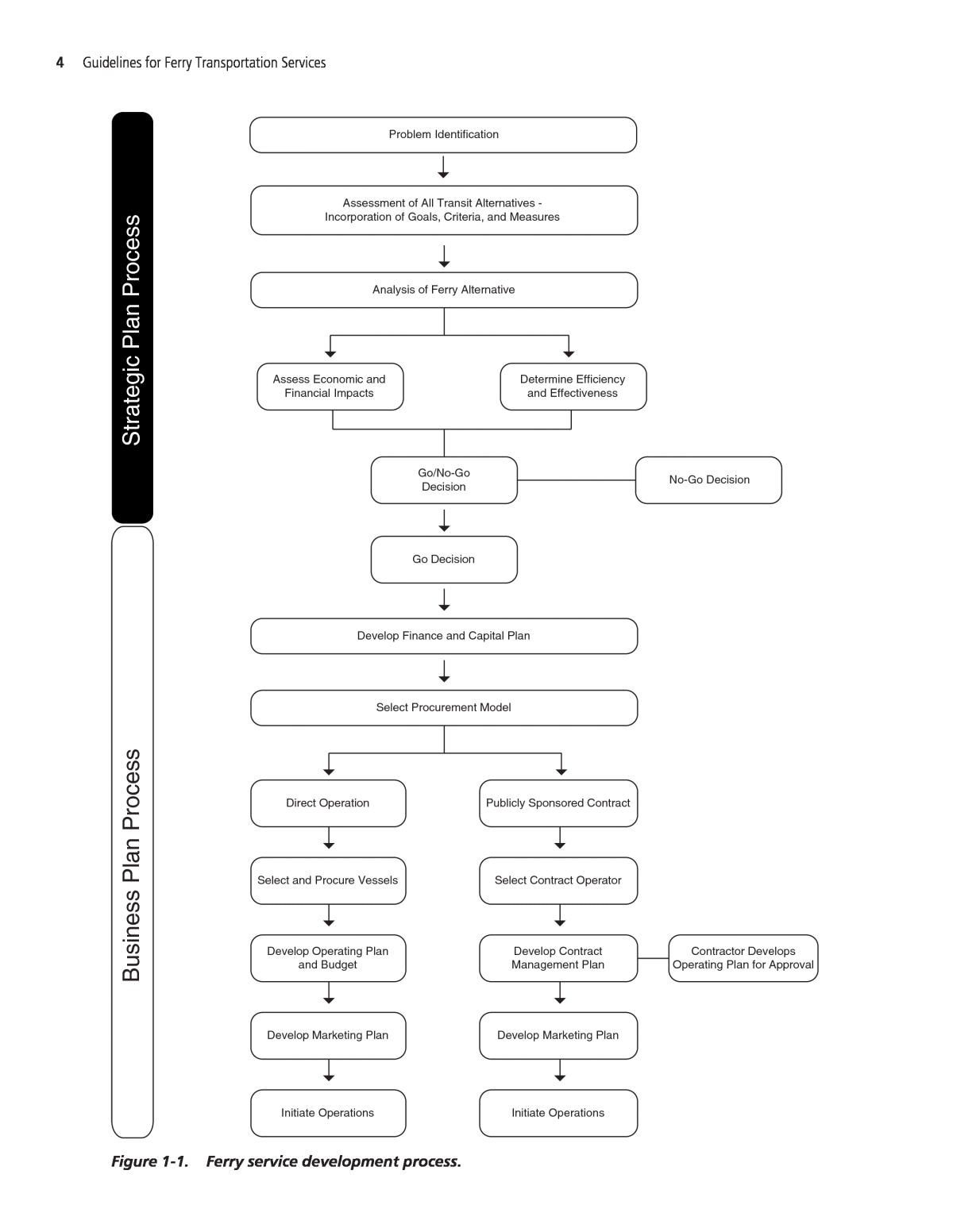
Background The purpose of this research is to investigate the state of ferry transit operations in North America and to develop practitionersâ guidance for the planning, marketing, operation, and management of ferry transportation systems. The research is intended to present a uniform un- derstanding of the status of ferries as well as options for how to approach planning and opera- tional activities. This guidebook is intended for use by operators large and small, in publicly or privately owned operations, for the development of ferry operations as a solution to a transporta- tion need. This research was developed through literature searches of previous studies, reviews of exist- ing government and state documents, telephone interviews with a broad selection of ferry oper- ators, in-depth case studies of eight ferry operators/ferry systems geographically dispersed across the North American continent, and peer review of the interim documents. The main body of this report contains the case studies and a guidebook. Two appendices pro- vide additional information to support the work documented within the main body of the re- port. Appendix A provides a listing of literature review sources, and Appendix B documents the results of a survey of ferry operators that was developed and implemented in this research. Objectives and Methodology The overall purpose of the research reported herein was to develop guidance for selecting water/ferry transit as the appropriate solution to an access requirement and guidance for oper- ating ferry services. An initial task was to develop a definition of ferry service in order to focus the practice guide- lines. Additional tasks focused on segmenting ferry service types, identifying appropriate roles for ferry service, and spotlighting operational practices to ensure well-operated and safe ferry systems. The end result is a list of criteria that decisionmakers and potential ferry operators can use to test the viability of potential services and operations. An important output of the research is a ferry service development process work flow that out- lines the steps necessary to take a ferry project from conception to initiation (see Figure 1-1). 3 S E C T I O N 1 Introduction
4 Guidelines for Ferry Transportation Services Assessment of All Transit Alternatives - Incorporation of Goals, Criteria, and Measures Analysis of Ferry Alternative Problem Identification Develop Finance and Capital Plan Select Procurement Model Assess Economic and Financial Impacts Determine Efficiency and Effectiveness Go/No-Go Decision No-Go Decision Go Decision Contractor Develops Operating Plan for Approval Publicly Sponsored Contract Select Contract Operator Develop Contract Management Plan Develop Marketing Plan Initiate Operations Direct Operation Select and Procure Vessels Develop Marketing Plan Initiate Operations Develop Operating Plan and Budget St ra te gi c Pl an P ro ce ss Bu si ne ss P la n Pr oc es s Figure 1-1. Ferry service development process.
Report Organization This report is divided into two parts. Part 1 provides background information on ferry service and presents case studies of ferry service. Part 2 presents guidance for practitioners and policymakers. Part 1 includes Sections 1 through 5. Following Section 1 (this section), which introduces the study, is Section 2, which provides a definition of the ferry services considered herein. Section 3 identifies ferry service typologies, and Section 4 lists the stakeholders and institutions affecting ferry services in the United States. Section 5 presents case studies of eight ferry operators (whose experiences and findings impact the report guidance). Part 2 includes Sections 6 through 9. Section 6 is an introduction to and summary of the prac- titionersâ guide to ferry services. Section 7 focuses on strategic planning issues. Section 8 expands on Section 7 by providing discussion of the key issues (often logistical) in ferry management and operations and approaches to these issues. Section 9 discusses ferry services within an overall strategy (either a corporate, private-sector strategy or a metropolitan or statewide transporta- tion strategy) and then provides guidance on developing a business plan for the ferry operation. Introduction 5
An important initial task is to define the ferry operations considered in this guidance. In the context of this research, ferry transportation is a transportation route similar to that provided by a highway or a railway. Definitions Merriam-Websterâs Collegiate Dictionary defines the noun form of the word âferryâ as âa place where persons or things are carried across a body of water (as a river) in a boatâ (Merriam-Webster Inc., 2003), and The New Oxford Dictionary of English defines ferry as âa boat or ship that carries people, vehicles and goods across a river or across a narrow part of the seaâ (Oxford University Press, 1998). The Random House Unabridged Dictionary defines a highway as âany public road or waterwayâ (Random House, 1997). Government legal definitions take this ordinary language and refine the definition of ferry service more specifically to be a transportation service using a boat or vessel as a common car- rier for passengers or passengers and vehicles (as a highway is open to all users), in a highway use (for purposeful travel between two points), within a specific ânarrowâ waterway. A vessel, there- fore, traveling from New York to Lisbon, is not a ferry because it is not a narrow waterway. A freight-only service is also not a ferry. Given these definitions, this research considers ferry ser- vice as a passenger transportation service that can also provide vehicle transportation, but that does not include non-point-to-point sightseeing marine services or freight shipping. Marine services that serve purposeful travel to and from recreational areas are considered ferries. The Bureau of Transportation Statistics (BTS) of the U.S. Department of Transportation ac- knowledges two types of ferry public transit modes: Ferry Transit (BTS Ferry Transit) and Ferry Intercity (BTS Ferry Intercity). BTS Ferry Transit is defined as scheduled ferry service running between points within a city or the same metropolitan area while BTS Ferry Intercity is defined as scheduled ferry service running between points that are not within the same metropolitan area or are not located in any metropolitan area (RITA, accessed April 8, 2010). In at least two states (North Carolina and Washington) and one territory (U.S. Virgin Islands), the state ferry systems are considered as part of the overall state highway system, as they provide critical linkages as part of the stateâs transportation system. On April 8, 2010, the U.S. Maritime Administration (MARAD) released its final rule defining the new Marine Highway Program that was originally established on October 9, 2008. While the term âmarine highwayâ has been loosely used to describe ferry transit service, the new MARAD rule firmly defines the term âmarine highwayâ to refer exclusively to short sea transportation. Thus, the term âmarine highwayâ does not refer to ferry transit, but the word âhighwayâ can be 6 S E C T I O N 2 Definitions and Types of Ferry Services
used to refer to ferries within a stateâs highway system. In the states of Washington and North Carolina, the state-operated ferry systems are considered as part of the statesâ highway system, waterway routes that are an extension of the roadway system. In this instance, ferry routes are part of an overall highway system. Based on the U.S. government documents discussed above and on the case studies developed for this project, ferry service can be categorized into the following: ⢠Transit (no vehicle access): â Ferry Urbanâconsisting of scheduled service between points within a city or metropoli- tan area (Under the BTS scheme, this would be BTS Ferry Transit). â Ferry Intercityâconsisting of scheduled service between metropolitan areas (Under the BTS scheme, this would be BTS Ferry Intercity). ⢠Highway â Ferry Essentialâconsisting of scheduled service between points outside a metropolitan area or between metropolitan areas and providing vehicle access (primarily BTS Ferry In- tercity although some are categorized as BTS Ferry Transit) almost always in areas without direct roadway access. Types of Ferry Service Varying types of ferry service are provided across the country. As defined in the second edition of the Transit Capacity and Quality of Service Manual (Kettleson & Associates, Inc., et al., 2003), the various service configurations include water taxis, passenger ferries, and automobile ferries. Water Taxis Water taxis are small watercraft that typically serve short cross-waterways or waterway circu- lation routes. Water taxis do not operate on fixed routes or use time-based schedules; rather, they operate on an on-demand basis, with service being variable throughout the day, depending on demand. (Because water taxis do not operate on a fixed route, they are not considered in this research. There are some marine services that have all the other aspects of ferry servicesâ scheduled service, purposeful trips, and so forthâwhich are marketed as water taxis; however, in this study they are considered ferries.) Passenger Ferries Passenger ferries are larger vessels that have higher passenger capacities and speeds than water taxis and that typically serve short- to moderate-length routes. This kind of ferry service will be referred to as âferry transitâ in this report. Passenger ferries operate on fixed routes with time- based schedules. Examples of passenger ferries operating within a metropolitan area include the New York Harbor cross-Hudson ferries, operated by NY Waterway, NY Water Taxi, and other carriers using 120â150 passenger-only vessels. Some passenger-only ferries operate between metropolitan areas or provide access to rural areas. These are categorized as Ferry Intercity, and examples include the U.S. Virgin Island fer- ries, the Victoria Clipper from Seattle, Washington, to Victoria, British Columbia, and the var- ious ferry services operating between Cape Cod and Marthaâs Vineyard in Massachusetts. Automobile Ferries Automobile ferriesâalso known as roll-on, roll-off (RO-RO) ferriesâtransport vehicles as well as passengers. They are typically used on longer routes across major bodies of water and on Definitions and Types of Ferry Services 7
low-volume rural roads crossing rivers. Automobile ferries operate on fixed routes with time- based schedules. Examples of automobile ferries include state ferry systems in North Carolina, Washington State, and in British Columbia. Some of these services can be categorized as BTS Ferry Transit (i.e., the Washington State ferry system, which connects Kitsap County to Seattle with ferry routes as short as 10 miles), but most are BTS Ferry Intercity since they generally con- nect areas that are distinct metropolitan areas or connect metropolitan areas to rural areas. For the purposes of this report, any vessel on a fixed route that carries automobiles will be referred to as âferry highway.â 8 Guidelines for Ferry Transportation Services
This research included a literature review of research on ferries over the last 20 years. This work identifies current ferry industry practices and procedures based on the literature review and an extensive survey of ferry operators that was developed for this report. The 2008 National Census of Ferry Operators (from BTS) reported that ferries operated on more than 350 routes spanning 37 states and three U.S. territories, as well as connecting to seven international destinations. BTS estimates that more than 100 million passengers use U.S. ferries annually. The largest ferry systems were the Staten Island Ferry, which carried 23 million pas- sengers, and the Washington State Ferry, which carried 13 million foot passengers and 11 mil- lion vehicles and vehicle passengers (RITA, accessed April 8, 2010). Ferry Functions Ferries provide three basic transportation functions in the United States within the definition of ferry service. These functions are the fundamental backbone of ferry service, with a hierarchy of importance in relation to regional landside transportation networks (Norris, 1994): ⢠Essential ferry routes with no viable land-based alternatives (called Ferry Essential in this report). These are essential ferry routes that provide year-round service to island or water- isolated areas that cannot be reached by road, bridge, or tunnel. These routes typically are operated by a public entity that is part of the regional transportation network, although they may be operated by private entities under government authorization. The routes are seen as marine highways to offshore communities that provide passenger, vehicle, and freight trans- fer to the mainland. Examples include the North Carolina Ferry System, Washington State Ferry, British Columbia Ferry System and the U.S. Virgin Island ferries, among others. ⢠Complementary ferry routes that are more efficient than land-based alternatives. These routes compete aggressively with automobile and potentially other public transit modes for time savings and accessibility. These routes are often commuter oriented. A good example is the Staten Island Ferry in New York, which provides a direct, 5-mile connection between Manhattan and Staten Island. The corresponding automobile trip is about 16 miles. ⢠Optional ferry routes with equivalent land-based alternatives. Optional ferry routes provide alternatives to automobile travel that may represent some time savings, exhibit greater relia- bility, and provide more amenities. The main goal of increased travel options is to provide al- ternatives to roadways, bridges, and tunnels that may be congested and overcrowded, thereby encouraging people to change travel modes. In the San Francisco Bay Area, the Vallejo Ferry operates on a 30-mile route between downtown Vallejo, a redeveloping industrial town, and downtown San Francisco. Both the ferry route and the parallel Interstate 80 are about the same distance to downtown San Francisco. However, during the peak period, Interstate 80 is extremely 9 S E C T I O N 3 Ferry Service Typologies
congested, with travel times approaching about 70 minutes, while the trip on the 34-knot (39-mph/63-kph) ferry is scheduled to be about 55 minutes, a savings of about 20 percent (Vallejo Baylink Ferry, accessed December 3, 2010). Ferry service can be further divided by geography. A typical ferry route is, on average, 11 to 30 minutes, although routes exceeding 2 hours are also common (up to about 40 miles or 65 kilometers). Ferries travel on waterways that are intercoastal (along the coastline), intra- coastal (lakes, rivers, bays, and sounds), and international. These waterways cross urban, coastal, and rural regions (Norris, 1994): ⢠Urban areas. Services provide trips within a metropolitan commuting area, with fixed sched- ules, sometimes with consistent âclockâ headways, but sometimes with inconsistent frequen- cies. Often, fixed-frequency schedules vary daily to accommodate commuters. Services include point-to-point transit (e.g., across a harbor), linear service with multiple stops (e.g., along a waterfront), circulator service (e.g., fixed route but not fixed schedule), and water taxi service (e.g., fixed landings with passenger pickup on demand). One example is the San Francisco Bay Area where six ferry routes connect the suburbs with downtown San Francisco. Other exam- ples include New York, where 21 weekday routes provide scheduled service across the Hudson and the East River into Manhattan. In addition, Seattle and Boston use commuter ferries within highly urbanized areas and Vancouver has a ferry connecting North Vancouver to the central business district (the SeaBus). ⢠Coastal areas. Services provide intercity and inter-island trips on saltwater and large fresh- water lakes. Travel times range from 1 hour to 1 day. Service frequency ranges from daily to weekly and may vary seasonally. Examples include the Lake Express and the Lake Michigan Car Ferry, operating from Michigan to Wisconsin across Lake Michigan; the ferries connect- ing Connecticut to Long Island, New York (Cross Sound and Port Jefferson Ferries); as well as the Washington State Ferry System and the British Columbia Ferry Services (BC Ferries). ⢠Rural areas. Services provide transportation across rivers and lakes where the construction of bridges is not warranted. Typically, these routes are short, carry a limited number of vehicles, and accommodate pedestrians and bicycles, and sometimes even operate on demand. Exam- ples include the Bluewater Ferry operating between Marine City, Michigan, and Sombra, Ontario; the Cave-in-Rock Ferry between Kentucky and Illinois; the Washington Island Ferry in Door County, Wisconsin; and ferry services in North Carolina. Ferry systems can also be categorized according to other characteristics, including the follow- ing (Norris, 1994): ⢠Commuter and recreational/tourism ferry. Many ferry systems historically have operated a combination of commuter and recreational service, especially private operators who want to optimize the use of their vessels. Public operators also offer off-peak and weekend service in addition to commuter routes. ⢠High-volume routes. These routes operate frequently, either as highway ferries or as transit passenger ferries, but do not represent a large number of services. ⢠Low-volume highway or transit link. The vast majority of the ferry routes operating in the United States are relatively small routes with low volumes that serve as substitutes for bridges or tunnels or provide service between islands and the mainland. ⢠International, interstate, intrastate, or intercity operations. Most systems operate within one jurisdiction. Systems that cross state or country boundaries typically have different oper- ating characteristics than those of commuter and recreational/tourism ferries. Systems in Alaska and Washington are examples where additional amenities and services are provided for longer journeys. ⢠Public, private, or public/private operations. In the United States, there are three types of operations that provide waterborne transportation. Public systems provide ferry service where 10 Guidelines for Ferry Transportation Services
there is a gap in the transportation network. Private systems operate in the same fashion but without public subsidies; therefore, they tend to be located in places where demand is high enough to generate a profit. A public/private system is one in which a public entity subsidizes the operation of a private contractor. ⢠Existing, expanding, or new ferry systems. Systems can be categorized according to whether they are expanding operations (adding more trips or routes to an existing service), launch- ing a new service, or maintaining an existing level of service (e.g., the Staten Island Ferry in New York). Ferry Route Typology This report uses three âidentifiersâ for ferry routesâFerry Urban, Ferry Intercity, and Ferry Essential âand then uses a further typology that can be applied to the ferry route identifiers. Given the wide range of ferry services operating in the United States, understanding the different markets for ferry systems is important for making planning decisions about new routes and services. These markets can be considered part of a typology including the follow- ing (Norris, 1994): ⢠Ferry in lieu of bridge or tunnel. While bridges and tunnels have replaced many ferry sys- tems, some systems have not been replaced. More recently, ferry systems have been initiated to avoid constructing a new bridge or tunnel. The ferry service is seen as a lower cost, more efficient alternative to costly infrastructure projects. Good examples include the Washington State Ferry System, where the state purchased the existing private ferry operators until fixed links could be built. A few years later, policymakers decided to abandon new bridges in favor of continuing the ferry system. ⢠Ferry in lieu of parallel highway or rail. Where land availability is constrained or building a new highway or rail route is too costly, the decision to maintain or implement a ferry service is selected. BC Ferries Inland Passage service between Prince Rupert and Port Hardy serves isolated coastal and island communities including Bella Coola, Bella Bella, Klemtu, and Shearwater and is an example of this type of service. The Alaska Marine Highway System also operates on the Alaska portion of the Inland Passage from Prince Rupert to Skagway, with about a dozen stops along the routes (BC Ferries, 2010). ⢠Ferry to island(s). One of the fundamental tasks of ferry systems is to serve areas without other means of access. Connecting islands with the mainland is a common service of many ferries in the United States and is also the backbone for many systems that provide other commuter- oriented routes. Examples include ferry service to Marthaâs Vineyard and Nantucket (MA), Washington Island (WI), and Mackinac Island (MI), and ferry service in the U.S. Virgin Islands. ⢠Ferry in addition to parallel bridge or tunnel. Water transportation services often operate in parallel with existing bridges or tunnels. Older systems rely on ridership gained from years of operation, while newer systems can be implemented to provide additional commuting op- tions when bridges and tunnels are congested. The best example of this policy decision is the Golden Gate Ferry System. More than 40 years ago, the Bridge District directors decided to increase corridor capacity by instituting a ferry system rather than adding highway and bridge capacity. Today the ferry services provide about 1,600 seats during the peak hour, or the same capacity as about three-quarters of a highway lane. New York implemented a similar policy in the mid-1980s, using ferries to increase cross-Hudson capacity rather than adding new high- way lanes. Also in New York, the Staten Island Ferry continues to operate despite the opening of the Verrazano-Narrows Bridge in the 1960s. The Staten Island Ferry continues to provide a direct and fast trip relative to the less direct highway. ⢠Ferry in addition to parallel highway or rail. Similar to ferries that operate along with a par- allel bridge or tunnel, ferry service may be introduced parallel to highway or rail to provide Ferry Service Typologies 11
congestion relief, to encourage alternative forms of transportation to the automobile, or to be a mitigation measure for landside developments. A pilot project to operate ferries between Oceanside and San Diego in California was attempted in 2003, but was terminated due to low ridership. Both parallel rail service and a high-speed freeway served the same corridor. ⢠RO-RO ferry as highway link. RO-RO ferries provide connections for automobiles and trucks between roads and highways on opposite sides of water bodies without bridges or tunnels. Ser- vices are initiated in areas where traffic volume is too low to warrant a bridge or environmen- tal concerns preclude a road crossing. Examples include the Connecticut-to-Long Island ferry services, BC Ferries, Alaska Marine Highway System, and Washington State Ferries. Table 3-1 summarizes ferry service and planning characteristics as identified in previous research and studies and synthesizes them into an approach that is used in this report. 12 Guidelines for Ferry Transportation Services In Lieu of Bridge/ Tunnel In Lieu of Parallel Highway/Rail To Islands In Addition to Parallel Bridge/Tunnel In Addition to Parallel Highway/Rail Transit Ferry Urban Ferry Intercity Highway Ferry Essential Primary Characteristics Secondary Characteristics Fe rr y Se rv ic e D ef in iti on Service and Planning Characteristics Table 3-1. Ferry service definitions and characteristics.
In the United States, ferries have been regulated and chartered due to their historic status as com- mon carriers and âhighways.â Many of these regulations include state utilities commission âcertifi- cates of necessityâ establishing routes. Sometimes this economic regulation includes approval of fares and tariffs; other times, states either operate directly or contract for ferry operations as part of their state highway systems, such as when there is no bridge connecting a state highway. Securing landing rights is another ferry service requirement that usually involves the coopera- tion and often the approval of a state or local government. The breadth and scope of state regula- tion varies from little oversight to broad requirements requiring the approval of a regulating body. In addition to state involvement, the federal government also provides safety oversight and financial support. Federal Regulatory Agencies Each of the agencies described below has different involvement with ferries, including provid- ing funding, regulation, and oversight as well as ensuring safety and security onboard vessels and at ferry terminals. U.S. Department of Transportation The U.S. DOT develops and coordinates policies that provide an efficient and economical national transportation system, with due regard for need, the environment, and the national defense. It is the primary agency in the federal government with responsibility for shaping and administering policies and programs to protect and enhance the safety, adequacy, and effi- ciency of the transportation system and services. Within the U.S. DOT, the Office of the Secre- tary, FHWA, MARAD, and FTA all can provide oversight and assistance for ferry services. In addition, RITA provides multimodal research for U.S. DOT (Habib et al., 1980). Federal Highway Administration FHWA coordinates highway transportation programs primarily in cooperation with states. As part of this mission, FHWA also funds ferries through traditional highway programs and spec- ified ferry funding grants. Maritime Administration MARAD promotes development and maintenance of an adequate, well-balanced, United States merchant marine. MARAD also administers the Title XI ship financing program, which provides federally guaranteed loans for shipbuilding projects. Ferries are eligible for the Title XI program and have been financed through the program in the past. 13 S E C T I O N 4 Stakeholders and Institutions Affecting Ferry Services
Federal Transit Administration FTA can provide financial assistance for passenger (generally Ferry Transit Urban) ferry services as part of grant programs. Eligible costs include planning, design, and construction (and some- times operating expenses related to preventative maintenance). Transit systems are required to submit a variety of operational and financial data annually for insertion into the National Tran- sit Database (this reporting affects the formula allocations to transit agencies around the country), and, as part of this reporting, ferry routes are given the same consideration as fixed-rail routes. Research and Innovative Technologies Administration During deliberations for the Transportation Equity Act for the 21st Century (TEA-21) in 1998, Congress identified a gap in the understanding of how to evaluate federal funding requests for fer- ries. To remedy this gap, Congress commissioned a ferry study in 2000 that was carried out by RITA and was called The National Ferry Study. The study included a detailed inventory of all ferry oper- ations and reported on the potential for new ferry operations, fast ferry opportunities, and alterna- tive fuels. The study allowed various ferry-related government agencies and departments to form a partnership in which different agencies had specific tasks and roles. Ferry-related planning, fund- ing, and construction had previously been shared among local, state, and national agencies. The study provided, perhaps for the first time, a clear delineation of agency roles and responsibilities. U.S. Department of Homeland Security DHS was created through the Homeland Security Act of 2002. Ferry operators and systems interface with DHS primarily through the U.S. Coast Guard and TSA. International operators also are subject to Immigration and Customs Enforcement (ICE). U.S. Coast Guard USCG is an agency under DHS, but can also become a branch of the United States military. The USCG is a maritime, military, and multimission service unique among the military branches for having domestic (and international) maritime law enforcement duties and also being a federal mar- itime safety and regulatory agency. USCG provides safety oversight for all vessels, including ferries, and conducts annual vessel inspections. All vessels must be USCG certified, and maritime operat- ing personnel require USCG licenses. USCG also mandates safety procedures for crew members and vessel operations and can conduct vessel escorts, security patrols, and other actions to ensure that vessels operating in the United States comply with domestic security standards. Ferries are often included as components of USCGâs maritime security plans for urban harbors. Transportation Security Administration TSA provides security for the movement of people and commerce in and to the United States. TSA administers the Transportation Worker Identification Credential (TWIC) program, which is a common identification credential for all personnel requiring unescorted access to secure mar- itime areas and vessels and all mariners holding USCG-issued credentials. Congress directed TSA to issue a biometric security credential to individuals with unescorted access to secure areas of fa- cilities and vessels and all mariners holding USCG-issued credentials or qualification documents. Other Federal Agencies U.S. Army Corps of Engineers The U.S. Army Corps of Engineers (USACE) is a federal agency and a major Army command made up of civilian and military personnel. In the United States, USACE builds waterways and 14 Guidelines for Ferry Transportation Services
flood protection projects, which are often used for vessel operation. In addition, USACE regu- lates some aspects of navigable waters, including enforcing environmental regulation through dredging permits and wetlands protection. U.S. Environmental Protection Agency EPA is the federal agency that regulates discharges of pollutants into the water, ground, and air. Ferry operators are subject to EPA regulation on their discharges and emissions. In addition, the EPA administers grant programs that provide new technology designed to reduce emissions and improve efficiency. U.S. Fish and Wildlife Service (U.S. Department of the Interior) The U.S. Fish and Wildlife Service is a part of the U.S. Department of the Interior. The U.S. Fish and Wildlife Service may have jurisdiction over ferry docks and landings due to their potential impact on habitat. State and Local Agencies State and local agencies exercise regulatory control over shorelines and waterfronts and some- times exercise economic control over routes, fares, and schedules. The case studies presented in Section 5 of this report indicate a broad range of state and local agencies that impact ferry ser- vice. Such impact includes, for example, towns that through their zoning ordinances regulate terminals and other landside facilities, as well as states that regulate state-owned tidelands and control access to state resources such as personnel, funds, and lands. Funding Sources It should be noted that funding is fluid, as budgets and funding programs can change annu- ally. The purpose of the following discussion is to identify the range of funding sources currently in use at federal, state, and local levels. Federal At the federal level, funding for ferries can come from sources of highway and transit funding as well as from federal loan guarantees, federal tax deferral, and the American Recovery and Reinvest- ment Act (ARRA). Highway Federal funding for ferry vessels, terminals, and other ferry-related expenditures is available under various federal funding categories, including ferry-only funding, transit funding, and, in some cases, highway funding. For example, federal law has allowed states to use non-Interstate funds to build ferry infrastructure (including access roads and other facilities) when the route is part of a designated federally eligible highway (except Interstates). Beginning with the Inter- modal Surface Transportation Efficiency Act of 1991 (ISTEA), the Ferry Boat Discretionary Pro- gram has provided additional and separate funding for the construction of ferry boats and ferry terminal facilities. The Ferry Boat Discretionary Program was continued through the Trans- portation Equity Act for the 21st Century (TEA-21) and the Safe, Accountable, Flexible, Efficient Transportation Equity Act: A Legacy for Users (SAFETEA-LU). More recently, the 2009 federal Stakeholders and Institutions Affecting Ferry Services 15
stimulus bill, officially known as ARRA, authorized several ferry funding programs prior to Congress considering the next transportation appropriations bill. Transit FTA can fund ferry boats through its normal formula and discretionary funding sources. FTA funding has been used for vessels, terminals, and other facilities that provide for an urban, mass transit passenger ferry service. Federal Loan Guarantees Both MARAD and FHWA (through the Transportation Infrastructure Financing Innovations Act, TIFIA) can provide loan guarantees for ferry operators to purchase vessels. In addition, TIFIA can also fund ferry facilities and other landside projects. These programs are not grants, however, and the funds must be repaid or the government repossesses the assets. As a result, both programs have strict credit and business-plan criteria. While MARAD can finance 90 percent of a vessel, TIFIA is limited to one-third of the project cost. Federal Tax Deferral The capital construction fund program (CCF) is a program created to encourage reinvestment by U.S. maritime companies. The fund is not direct assistance, but rather allows the maritime entity (including ferry operators) to defer a portion of tax monies that would otherwise be paid to the U.S. Treasury during the tax year. Like a maritime IRA, the CCF program allows the mar- itime entity to accumulate and use otherwise taxable earnings for the purposes of acquiring, con- structing, or reconstructing vessels built and documented in the United States and operated in the United States foreign, Great Lakes, or noncontiguous domestic trade and in the fisheries. The program is administered through MARAD (for private ferry operators) and requires a contract between the operator and MARAD. American Recovery and Reinvestment Act ARRA appropriated millions of federal dollars for the ferry industry to be disbursed through a number of different transportation-related agencies for a number of different purposes. Exam- ples of how the ferry monies were distributed through the various agencies and the types of allocations are the following: ⢠The Ferry Boat Discretionary Program received $60 million to be dispersed for ferry boat and terminal construction. ⢠Through the FHWA, ferries could qualify for some of the $27.5 billion stimulus funds as intermodal connectors, bridge improvements, and pavement construction. ⢠Under the FTA, $323 million was set aside especially for ferries. ⢠The EPA has set aside $32 million for diesel emission reductions in port areas that ferries may qualify for. ⢠The U.S. Department of the Interior has $20 million designated for ferries providing improved access to national parks. ⢠DHS has $150 million in a port security grant to support the TWIC program. Ferry operators can be supported in this grant. State and Local Programs Several metropolitan agencies and authorities, as well as states, provide funding for ferry oper- ations and capital improvements. These sources vary from state to state, but they include many of the following: ⢠Toll revenues. Often ferries are either part of a larger toll crossing authority or are cross- subsidized to provide supplemental capacity in a bridge corridor. 16 Guidelines for Ferry Transportation Services
⢠General transit revenues (often including gas taxes). These revenues are provided to fund the ferry service as part of the overall transit system. ⢠Port revenues. Some ports and port authorities subsidize ferries to generate additional traffic and support waterfront real estate development. ⢠Development revenues. Some ferries are financed through either special taxes or real estate fees to provide access to remote development sites or areas poorly served by other transporta- tion services. Stakeholders and Institutions Affecting Ferry Services 17
Eight ferry operators were carefully selected for case studies to represent the wide breadth of the ferry business. The selected operators include small Midwestern vehicle and passenger fer- ries, passenger-only ferries in New York Harbor, and ferries in the U.S. Virgin Islands and the Pacific Northwest. Initial Survey of Ferry Operators The case studies were guided by the initial findings from a survey of more than 40 ferry operators, which led into focusing on narrower topics for further development in the research program. The survey was conducted through telephone interviews from May through July 2009. The telephone interviews covered the same topics as the literature review: ⢠Ferry planning ⢠Ferry operations ⢠Ferry funding ⢠Ferry disaster response, safety, security, and risk ⢠Ferry environmental assessment, planning, and mitigation ⢠Ferry marketing The survey sample included representatives of the full range of ferry operators, from very small operators to those operators that carry more than a million passengers, from seasonal operators to year-round operators, and from privately owned and operated systems to publicly operated systems at the federal, state/provincial, and local levels. The sample also included operators from various geographic regions. The survey was designed to allow for multiple respondents from the same operator to answer questions, which occurred during interviews with larger operators. A $100 incentive was offered to encourage participation so that the desired number of interviews would be completed. Forty-three interviews were completed. The survey respondents answered anonymously dur- ing the reporting process. Characteristics of the respondents include the following: ⢠Of the fifteen publicly owned ferries surveyed, one is a federal agency, seven are state or provincial governments, and seven are local operators. ⢠Twenty of the ferry operators surveyed are privately owned and operated, while seven are pub- licly owned but operated by private companies under contract. ⢠Fourteen ferries are seasonal, while sixteen operate year-round. ⢠The number of passengers carried annually ranged from less than 500 to 2 million. 18 S E C T I O N 5 Ferry Case Studies
⢠Twenty-five respondents operated one to two lines, ten respondents had three to six lines, and six respondents had seven or more lines. The complete results of the survey are included in Appendix B. About the Case Studies Based on the findings from the ferry operator survey, the research team focused on in- depth case studies of eight ferry systems or operators. In some cases, the case study focused on one operator; in other cases, entire systems comprising multiple operators in one region were considered. The eight ferry systems/operators selected for the case studies were ⢠ConnecticutâLong Island (New York) ferry services ⢠New York Harbor ferries ⢠North Carolina Department of Transportation Ferry Division ⢠U.S. Virgin Islands ferry services ⢠Washington Island Ferry Line (Wisconsin) ⢠Seattle Metropolitan Ferry System (Washington) ⢠Hawaii Superferry Service ⢠BC Ferries (British Columbia, Canada) It should be noted that the Hawaii Superferry system was not implemented; however, as a case study, it provides important examples of actual and potential causes of failure. Based on both the case studies and on the earlier survey of ferry operators, ferry services in North America can be broadly categorized as either passenger systems in primarily metropolitan/urban areas or as essential highway extensions in more rural areas and island and coastal communities. Within these categories, the planning, marketing, and expectations of each type of service are dissimi- lar, even while the actual operations of the vessels are similar. Each of the eight case studies opens with âQuickfacts,â a table listing basic data about the ser- vice including service category, number of routes, number of vessels, annual number of passen- gers, annual number of vehicles, and the age of the fleet. Each case study continues with sections describing the ferry operator/system history, organizational structure, operational structure, financial structure, and planning issues. ConnecticutâLong Island (New York) Ferry Services Ferry Case Studies 19 Operator Service Category # of Routes # of Vessels Annual Passengers Annual Vehicles Fleet Age (years) Port Jefferson Ferry HighwayâFerry Essential 1 3 1,000,000 380,000 7â24 Cross Sound Ferry HighwayâFerry Essential/ TransitâFerry Intercity 1 8 1,300,000a 450,000 21â69 Viking Ferry Linesb TransitâFerry Intercity 1 1 ~2,000 n/ac 5 aIncludes 195,000 fast-ferry passengers. bPlease note that because Viking Ferry Lines has limited service (only on weekends during the summer), limited analysis is provided below. cNot applicable. Quickfacts
History Modern daytime ferry service between Connecticut and Long Island began in 1884 when the Bridgeport & Port Jefferson Steamboat Company (Port Jefferson Ferry) began operation from the Connecticut shore to the midpoint of Long Island, New York. While other maritime services had operated (often on a weekly or twice-weekly schedule), the new daily scheduled service (dur- ing all seasons except winter when service was provided 3 days per week) transported Long Island farmers and their agricultural products to Connecticut and allowed Bridgeport merchants to sell products to farmers in turn (Sheahan & Conniff, 1983). The Port Jefferson Ferry began with one vessel; in 1889, the owners purchased a larger, 600- passenger vessel. When automobiles became common, the Port Jefferson vessels were retro- fitted to carry them, and this became an increasingly important revenue source for the company. By the 1920s, traffic had increased enough to require a second vessel. The Depression caused traf- fic to drop, but with World War II passenger and freight traffic increased. In the late 1960s, the company had purchased a used vessel to add to the fleet. While there was recurring considera- tion of bridging Long Island Sound, the projects never occurred, and the Port Jefferson Ferry continued to be the primary access from Central Long Island to Connecticut. In the 1980s, the company added two new, faster vessels: the Grand Republic and the Park City. Two additional vessels were purchased in 1999 and 2003. Service from Stonington, Connecticut, to Greenport, New York (terminal of the Long Island Railroad), began in the mid 1800s. By the 1940s, the service evolved into the New London (Con- necticut) to Orient Point (New York) route that currently operates (Cambridge Systematics, Inc., et al., 2005). In 1975, John Wronowski purchased the New London Freight Lines ferry service and changed the name of the ferry service operating between New London and Orient Point to Cross Sound Ferry Services Incorporated. Starting with three vessels purchased from the previous operator, Cross Sound began an incremental but consistent capital improvement program. In 1978, the company developed a new ferry terminal just to the north of the existing New London Amtrak Station. New vessels were purchased in 1977, 1979, and 1983, and in 1984, the company pur- chased and rebuilt an existing vessel. In 1989, 1998, 1999, and 2003 additional vessels were added to the fleet (Cross Sound Ferry Service, Inc., 2008). In 1995, Cross Sound added a high-speed ferry to complement its conventional vehicle ferry. The Connecticut casinos had increased walk-on passengers to the point where the existing pas- sengers were being inconvenienced. The Sea Jet 1 is a wave-piercing catamaran designed in Aus- tralia and built in Washington state. Both the ride-control system and the water jets were ini- tially unreliable, but over a period of about 5 years, Cross Sound staff brought the vessel to a high level of service reliability (Interview with Cross Sound Ferry, January 7, 2010). Both Cross Sound and the Port Jefferson Ferry report that passenger volumes have declined by about 10 to 15 percent and vehicular volumes are about 10 to 25 lower than 2004, which rep- resents the highest year. In addition, both carriers noted that truck volumes, which are prima- rily agricultural and construction related, declined by as much as 40 percent Organizational Structure Both the Port Jefferson Ferry and Cross Sound Ferry Service are privately owned and are part of larger maritime enterprises. The Port Jefferson Ferry was purchased in 1961 by the McAlllister Towing and Transporta- tion Company, which operates 70 tugboats and 24 tractor tugs in 12 ports. The Port Jefferson Ferry owns the terminal in Port Jefferson but leases a terminal in downtown Bridgeport from the Bridgeport Port Authority. 20 Guidelines for Ferry Transportation Services
Cross Sound Ferry Service is part of the Wronowski Marine Companies, which includes Thames Towboat Company, Thames Shipyard & Repair, and Block Island Ferry Services. The Wronowski enterprises employ up to 400 people and have an annual payroll of approximately $16 million. All facilities used by Cross Sound Ferries, including terminals and vessels, are owned by the company. It should be noted that the company has received public funding to repower its vessels to reduce fuel consumption and emissions. Operational Structure System/Service Routes Three private operators provide service across Long Island Sound, as shown in Table 5-1 and Figure 5-1. Ferry Case Studies 21 Table 5-1. ConnecticutâLong Island ferry system routes. Operator Route Service Season Service Schedule Crossing Time Port Jefferson Ferry BridgeportâPort Jefferson Year-Round Departures 60 minâpeak season and peak days 90 minâother times 75 min Cross Sound Ferry New Londonâ Orient Point Year-Round Departures 60 min 90 min Viking Fleet Ferries New Londonâ Montauk Seasonal Selected sailing days 60 min Figure 5-1. ConnecticutâLong Island ferries route map.
BridgeportâPort Jefferson Ferry. The BridgeportâPort Jefferson route is operated by Port Jefferson Ferry. The crossing time between Bridgeport, Connecticut, and Port Jefferson, New York, is about 75 minutes one way. Port Jefferson Ferry uses three vessels to provide ferry service: the Grand Republic, the P. T. Barnum, and the Park City. Figures 5-2 and 5-3 show photographs of Port Jefferson ferries. The Bridgeport ferry terminal is located in downtown Bridgeport and is adjacent to the Bridge- port train station. Bridgeport is Connecticutâs largest city and is about 60 miles east of New York City. The company leases about 3.5 acres, including the terminal and dock, from the Bridgeport Port Authority. The facility provides space for automobile queuing, as well as limited kiss-and- ride capacity. The Bridgeport Port Authority is planning to build an onsite garage for the ferry ter- minal; in the meantime, automobile parking is also available in structured parking on the other side of the train tracks and freeway. There is a large structured lot close to the ferry terminal, and ferry passengers are allowed to use it on weekdays and on weekends when there are no stadium/ 22 Guidelines for Ferry Transportation Services Figure 5-2. Port Jefferson ferry approaching the Long Island terminal. Figure 5-3. Port Jefferson ferry vehicle deck.
arena events. The Bridgeport ferry terminal provides good intermodal connectivity between com- muter and intercity rail and local and intercity bus service and good vehicular access from the Connecticut Turnpike. The parking access is limited, and the pedestrian path from the structured parking into the terminal is not attractive. The elevated Interstate highway and railroad structures create a large visual and physical barrier between the ferry terminal (and the waterfront) and the downtown. Cross Sound Ferry. Cross Sound Ferry operates a ferry route across Long Island Sound from New London, Connecticut, to Orient Point, New York. The New LondonâOrient Point Ferry operates year-round from the New London train/bus station to the far northern tip of Long Island at Orient Point. The one-way crossing time is 75 to 80 minutes. During the summer, ser- vice operates every 90 minutes; on Fridays, Sundays, and holidays, ferries operate as frequently as hourly. In the winter, service is reduced to seven round trips on weekdays. Cross Sound Ferry has a fleet of seven conventional ferries that operate at speeds between 12 and 15 knots and can carry from 22 to 120 automobiles and from 130 to 1,000 passengers. In addition to the conventional ferries, during the spring and summer, Cross Sound also oper- ates a high-speed (30-knot) ferry on the same route (Sea Jet 1). This ferry seats 400 passengers but carries no vehicles. The Sea Jet1 can sail between Long Island and New London in about 40 minutes and operates up to six round trips daily. Both the New London Ferry Terminal and the Orient Point Terminal are owned by Cross Sound Ferry. In New London, the ferry terminal is adjacent to downtown and the train station and intercity bus station and also has connections to the local transit system. About 11 Amtrak trains serve the train station in each direction daily. However, the railroad has an at-grade cross- ing, which creates an awkward pedestrian path connecting downtown, the train, and the ferry. Automobile parking for ferry passengers is available in a municipal garage nearby. Shuttle buses operate to the Foxwoods Casino, and New England colleges often shuttle students to the New London Ferry Terminal when school sessions begin and end. The New London Ferry Terminal is located on a 30-acre site at the mouth of the Thames River, with queuing areas leading to the conventional automobile ferry and a separate dock for the high-speed catamaran. The terminal uses an Internet-based reservations system that provides the customer with the ability to print a bar-coded boarding pass. Orient Point is located at the east end of Long Islandâs North Fork. Access from the west is via NY Highway 25, a two-lane rural road. The terminal has a queuing area for the conventional vehicle ferries and a parking lot with space for about 250 automobiles. The Long Island Railroad (LIRR) terminal in Greenport is about 7 miles to the west. Monday through Saturday bus ser- vice is provided hourly during daytime periods and connects Orient Point with Greenport and Riverhead. During 2003â2004, Long Island Sound communities studied the potential of ferry service between Connecticut and Long Island and between Connecticut and Manhattan. More than 50 possible sites were investigated for possible service and were ranked based on community acceptance, land use compatibility, and technical and market feasibility. The study identified six fast ferry routes (including two routes already operated by conventional craft) as viable, and two new conventional ferry routes in the first screening. However, after further technical review and comments from local governments, the study recommended only one new Connecticut to Long Island service and three Connecticut to Manhattan services. Several water taxi services were also recommended for further study. Viking Fleet Ferries. During the summer season, Viking Fleet Ferries operates a ferry service from Montauk, New York, to Cross Soundâs New London Terminal. This service only operates on Ferry Case Studies 23
Friday and Sundays and some holidays. The crossing time from Montauk to New London is about one hour. Viking Fleet uses a 225-passenger monohull to provide this service. Viking Fleet is pri- marily a party fishing operator but also operates daily scheduled ferry service from Montauk to Block Island, Rhode Island. Facility and Vessel Maintenance BridgeportâPort Jefferson Ferry. The Port Jefferson Ferry vessels carry 85 to 120 automo- biles and 1,000 passengers. Over the last several years, the ferry company has received federal funding to repower its vessels with more modern and fuel-efficient (and less carbon-intensive) engines. Not only have emissions been reduced by about 13 percent, but power has been increased to 1,000 horsepower, and the engines operate with less vibration and noise. At Bridgeport, Port Jefferson Ferry pays a rent of about $150,000 annually (including the util- ities), which includes dock access, the queuing area, and a modest terminal structure. In addi- tion, the Port Authority charges about $1 per passenger, which is, in effect, a passenger facili- ties charge. This charge has been litigated between the Port Authority and BridgeportâPort Jefferson Ferry and is currently in court for final disposition. In response to the Port Author- ityâs passenger tariff, the ferry company has proposed to relocate to another site, away from downtown Bridgeport. On Long Island, Port Jefferson Ferry owns the ferry terminal and about 280 linear feet of shoreline to perform maintenance work and administrative functions at the Port Jefferson Ter- minal. The Town of Brookhaven and the Village of Port Jefferson provide several parking lots, totaling about 200 spaces, within walking distance of the Port Jefferson terminal. The LIRR sta- tion, which has service to New York City, is about a mile south of the ferry terminal. Local bus ser- vice is provided between the ferry terminal and the LIRR station on four routes, with a combined frequency of about every 20 to 30 minutes. Highway access to the ferry dock is via non-grade- separated state highways and local roads. The ferry terminal is about 10 miles from Interstate 495 in Medford on Central Long Island. Cross Sound Ferry. Over the last several years, Cross Sound Ferry, like the Port Jefferson Ferry, has received federal funding to repower its vessels with more modern and fuel-efficient (and less carbon-intensive) engines. Cross Sound Ferry has achieved a 20-percent reduction in emissions and fuel consumption with this retrofit. The company also maintains its vessels and rebuilds engines at its own shops and provides commercial repair services to other vessel operators. Cross Sound esti- mates that its largest ferry, the John H., which carries 120 automobiles and 1,000 passengers, burns about 190 gallons of fuel on each one-way trip. The Sea Jet 1, a 30-knot, 400-passenger-only fast ferry, burns about 130 gallons of fuel on each trip (Adam Wronowski, Cross Sound Ferry, personal communication, March 22, 2010). Staffing Levels BridgeportâPort Jefferson Ferry. Port Jefferson Ferry employs about 175 people during the peak season and about 125 in the off-peak periods. Many of the employees have masterâs licenses, and all maritime employees have licenses. In addition, the company spends about $140,000 annu- ally on security training and monitoring and uses a variety of methods to ensure safe operation. Some of this expense is reimbursed by DHS funding. Cross Sound Ferry. Cross Sound employs about 300 employees in the peak season and about 150 in the off-peak season. The company hires almost all its employees at an entry level, trains the personnel, and encourages all of its maritime employees to become licensed masters. Cross Sound Ferry, like most ferry operators, takes security concerns seriously and has an active training pro- 24 Guidelines for Ferry Transportation Services
gram. Employees are trained to be aware and participate in drills and exercises. In addition, the company used federal funds to purchase lighting and surveillance equipment to provide addi- tional security. Financial Structure All ferries providing service between Connecticut and Long Island are privately owned and operated. The only government funding they have received has been for engine upgrades (relat- ing to emissions reductions) and security enhancements. These amounts are minor compared to their passenger and vehicle revenues, which exceed $50 million annually. For ConnecticutâLong Island route fares, see Table 5-2. Fares Both Port Jefferson Ferry and Cross Sound Ferry use variable pricing in peak periods. The peak periods for these services are generally on weekends and holidays. During these periods, some discountsâsuch as unlimited automobile passengers and discounts on trailers/buses, and so forthâare not available. In addition, commuter tickets are also available. Both the Port Jefferson Ferry and the Cross Sound Ferry have vehicle reservation systems. These systems provide the ability to manage vessel capacity and ensure the capacity is well used throughout the day. Market studies conducted by each company indicate that the majority of ferry passengers live on Long Island. For the BridgeportâPort Jefferson and Cross Sound Ferry services, about 55 to 60 percent of the passengers originate on Long Island. Most Cross Sound Ferry passengers reside in Suffolk County (the easternmost county). The other 45 percent of passengers are distributed throughout Central and Eastern New England. In addition, Port Jefferson Ferries reports that about 70 percent of its walk-on, return-day-trip passengers originate in Bridgeport (these trips make up about 20 percent of their total passengers). Funding Sources As all of the operators in this case study are privately owned, each garners revenues from a vari- ety of sources. Cross Sound Ferry and Port Jefferson Ferry obtain revenues through passenger fares, onboard and terminal concession stands, and restricted federal emission grants. Viking Ferries also has a large charter and private rental business that supplements their passenger ferry service. Ferry Case Studies 25 Table 5-2. ConnecticutâLong Island ferry system route fares. Route Operator Automobile Ferry Fare Adult Walk-on Child Walk-on Automobile Bicycle Motorcycle BridgeportâPort Jefferson Port Jefferson Ferry $17.00 Free $51 Free $29.75 New Londonâ Orient Point (Automobile Ferry) a Cross Sound Ferry $14.51 $6.00 $47.67 (includes $2 Port tax) $4.15 $27.98 New Londonâ Orient Point (Sea Jet 1)b $20.21 $6.22 n/ac n/a New Londonâ Montauk Viking Fleet Ferries $40.00 $25.00 n/a $7 n/a aCross Sound charges a floating âsurchargeâ against a base fare that reflects changes in fuel prices. bThis is a passenger-only ferry. cNot applicable.
Planning Issues Both Cross Sound Ferry and Port Jefferson Ferry have large, well-established operations. In interviews, their executives expressed comfort with their maritime operations, their ability to maintain and operate vessels, and their ability to provide necessary capital enhancements needed to maintain market share. Both operators, however, identified government leadership and public policy as important to enhancing the ability of the marine transportation mode to divert automobiles from the highway system and to create more sustainable transportation systems. Both Cross Sound Ferry and Port Jefferson Ferry have experienced challenges in expanding their services due to local concerns and the high financial expense and permitting maze of investing in terminal facilities. Environmental and Regulatory Issues From a systems perspective, both Cross Sound Ferry and Port Jefferson Ferry noted that fer- ries could decrease energy consumption and help achieve other public policy goals. However, there is not a consistent recognition of the importance of and the opportunities provided by a marine highway system. The Long Island Sound Waterborne Transportation Plan (2005) esti- mated that ferries captured about 23 percent of the Long IslandâConnecticut travel. Ferries carry about 2.3 million passengers annually, which means that approximately 7.7 million passengers between Connecticut and Long Island use highway modes annually (or about 25,000 trips daily) (Cambridge Systematics, Inc., et al., 2005). Travel between Connecticut and Long Island can be accomplished via ferry or automobile. The ferry operators think of their catchment areas as an oblong circle where their Long Island terminals are located west of the midpoint. Trips within that oblong are ferry-competitive but trips outside are not. For comparison, Table 5-3 provides data for the trip from Huntington, New York, to Bridgeport, Connecticut, on highway and ferry. Table 5-4 shows the change in travel time and fuel use with a fast-ferry option. Table 5-5 provides data for a different trip from Long Island to New London via either high- way or ferry. As ferry speeds increase (or highway travel times decrease), the ferry catchment area increases because the ferry travel times become more competitive than the highway travel times. In all cases, using the ferry results in fuel usage reductions of about 15% to 25%, depending on automobile occupancy (the lower the automobile occupancy, the higher the fuel savings from ferries). In congested corridors, ferry travel times to the ferry terminal are com- 26 Guidelines for Ferry Transportation Services Table 5-3. Huntington (NY) to Bridgeport (CT)âautomobile vs. ferry travel. Mode Miles Travel Time Cost Per Vehicle Fuel Used HighwayâClear 75 80 min $40 4 gala HighwayâCongested 75 120 min $45 5 gal Automobile to Ferryâ Ferry to Bridgeport 25 130 min $70 3 gal per auto carried including ferry fuel used aAutomobile cost based on 55 cents per mile operating cost. This is the IRS allowance.
petitive with automobile travel times. Conventional ferries allow for automobile use at either terminal, but the passenger-only, fast-ferry market is limited by the need to complete trips beyond the immediate ferry terminal area. As a result, while using passenger-only fast ferries could be more fuel efficient than driving (per Table 5-4), the market for these trips may be limited and hence not financially viable. Land Use Issues Cross Sound Ferry and Port Jefferson Ferry mentioned that their Long Island host communi- ties are sensitive to increases in service and expansion of terminal facilities. However, both com- panies recognize that there is latent demand that cannot currently be accommodated and that results in additional highway trips and vehicle miles traveled. In New London, the town is interested in developing a multimodal center where ferries are one piece of the puzzle. The multimodal center is seen as an economic catalyst for redevelop- ment in the town center. Bridgeport is faced with urban design issues that limit the ability to create optimal pedestrian and bicycle environments that encourage movements between the train station and ferry termi- nal. It is unlikely that changes in the urban infrastructure scheme will change in the near future to allow for redevelopment to occur. Port Jefferson and Orient Point communities have both restricted land use growth around the ferry terminals. Emergency Response After the attacks of September 11, 2001, ferries provided the only transportation from Long Island. While there is no formal emergency response system that the ferry operators work with, a more structured arrangement is being considered by local and state authorities. Ferry Case Studies 27 Table 5-4. Huntington (NY) to Bridgeport (CT)âautomobile vs. fast-ferry travel. Mode Miles Travel Time Cost Total Fuel Useda HighwayâClear 75 80 min $40 1,600 gal HighwayâCongested 75 120 min $45 2,000 gal Automobile to Fast Ferry 25 70 min $30 730 galb a Calculation assumes 400 vehicles traveling from Huntington to Bridgeport. Fast-ferry alternative assumes a 25 mile drive to ferry terminal and then walk-on passengers. bBased on 1.5 passengers per automobile, 22 mpg per automobile, and $20 fast ferry fare per passenger Table 5-5. Riverhead (NY) to New London (CT)âautomobile vs. ferry travel. Mode Miles Travel Time Cost Per Vehicle Fuel Used HighwayâClear 200 220 min $110 10 gal HighwayâCongested 200 300 min $120 12 gal Automobile to Ferry 30 140 min $70 3 gal per auto carried including ferry fuel used
New York Harbor Ferries 28 Guidelines for Ferry Transportation Services Operator Service Category # of Routes # of Vessels Annual Passengers Annual Vehicles Fleet Age (years) New York Waterway Transitâ Ferry Urban 16 34 9,855,000 n/aa 8â25 New York Water Taxi Transitâ Ferry Urban 1? 11 438,000 n/a 3â9 Statue Cruises Transitâ Ferry Urban 1 1 146,000 n/a 17 Seastreak Transitâ Ferry Urban 2 4 1,095,000 n/a 6â9 Staten Island Ferries Transitâ Ferry Urban 1 10 23,725,000 n/a 5â45 aNot applicable Quickfacts History Birth, Growth, and Decline The history of scheduled ferry service in New York Harbor extends back more than 200 years. Rowboats connected Manhattan with Brooklyn before the Revolution. Service to Staten Island began in the 1820s. New York City records indicate that by 1860 eight ferries were authorized to operate across the Hudson River to New Jersey. After the Civil War, as both commerce and rail- way traffic increased, ferry traffic also continued to grow. The railroads built large ferry termi- nals in New Jersey to serve New York CityâErie Terminal, Central Terminal of New Jersey, Pennsylvania Terminal in Jersey City, the Lackawanna Terminal in Hoboken, and the West Shore Railroad Terminal in Weehawken. The first fixed link across the Hudson River was developed by the Manhattan & Hudson (now Port Authority Trans-Hudson [PATH]) urban trains and linked Jersey City, Hoboken, and Man- hattan. The Hudson Tubes opened in 1908 and immediately diverted passengers from the ferry services, although the Pennsylvania Railroad continued to operate its ferries from Jersey City. The Hudson Tubes carried almost 50 million passengers annually just a few years after opening and now carry about 85 million passengers. In 1910, the Pennsylvania Railroad opened Pennsylvania Station on 34th Street, a terminus for rail connections to New Jersey, through an extensive network of commuter trains and two under- water tunnels. These tunnels now carry about 45 million passengers annually under the Hudson. In 1927, the states of New Jersey and New York opened the Holland Tunnel, the first vehic- ular access into Manhattan from New Jersey. About 34 million vehicles annually now use the Holland Tunnel. In 1931, the George Washington Bridge opened between New Jersey and Manhattan and soon carried more than 5 million vehicles annually. In the late 1930s, the Port Authority opened the first bores of the Lincoln Tunnel into the midtown area of New York City. In 1950, the Port Authority Bus Terminal (PABT) opened near Times Square. The Lincoln Tunnel now carries more than 42 million vehicles annually, and the PABT handles about 200,000 passengers daily. The George Washington Bridge serves more than 106 million vehicles each year. Ferries also crossed the East River and connected Manhattan to Brooklyn and Queens. These ferries were among the first to cease operations when the city built the Brooklyn and the Williamsburg Bridges. In 1920, the Long Island Railroad was extended into Pennsylvania Sta- tion connecting Manhattan to Brooklyn and Queens directly with fast electric trains.
As a result of these new fixed links, ferry service dwindled. Passengers either took direct trains into Manhattan or drove their automobiles into the city. The last scheduled ferries operated from Hoboken to Manhattan in 1967 (Wikipedia, accessed March 4, 2010). Only the New York City- operated Staten Island Ferry continued to operate. Revival, Growth, and Stabilization By the early 1980s, the cross-Hudson fixed links were straining to keep up with demand. At the same time, industrial brownfield sites on the New Jersey side of the Hudson River became available as industry moved to new locations and factories became obsolete. The sites were large, which allowed for master planning and dense, efficient development. Additionally, these sites had views of Manhattan and direct access to the Hudson River. What they did not have was easy access from the mainland. Arthur Imperatore, the President of NY Waterway, credits Regional Plan Association staff with inspiring the New Jersey Waterfront reuse vision, which combined residential and com- mercial development with access improvements. The two major access improvements were direct ferry connections to Manhattan from multiple New Jersey terminals and a light rail sys- tem operating along the waterfront from Bayonne to Weehawken, which created a development spine and linked ferry terminals, PATH stations, and the NJ Transitâs Hoboken Terminal (Inter- view with Arthur Imperatore, New York Waterway, January 10, 2010). This vision has resulted in more than 6,000 housing units being developed on the west side of the Hudson between 1990 and 2000, with additional units developed over the last 10 years, along with millions of square feet of commercial space (U.S. Census Bureau). Mr. Imperatoreâs related firms initiated service from Weehawken, where he had purchased 350 acres of old railroad yards in the mid-1980s. Ferries operated from Port Imperial to West 38th Street in New York City. Within a year, approximately 1,500 daily passengers were rid- ing the Weehawken ferry (Regional Plan Association, 2006). Concurrently, the Port Author- ity was experiencing significant capacity issues in its tunnels, at the PABT, and on PATH. The Port Authority considered extending PATH station platforms to allow longer trains, but this alternative was too costly. Instead, the agency decided to try ferries. In the mid-1980s, the Port Authority issued a Request for Proposals from parties interested in providing ferry service from the NJ Transitâs Hoboken Terminal to lower Manhattan (Interview with Port Authority, January 10, 2010). A 2006 Regional Port Authority white paper summed up the contemporary role of ferries in New York harbor: Over the last 100 years or more [ferries have] gone from essential to non-existent (with the excep- tion of the Staten Island Ferry) and then in the last twenty years to a role that might best be described as âniched.â These niches include ferry services that are either part of intermodal connections or in other ways complement existing transit modes, services that provide better options than the existing ground modes, and services that can open up new development opportunities. When searching for additional ferry service opportunities, it is these characteristics to be kept in mind. (Regional Plan Asso- ciation, 2006) New York Harbor now has 21 ferry routes serving Manhattan operated by six different ferry operators (five private operators and one public agency). Most routes are 3 to 5 miles long and take 10 to 15 minutes. More than 30,000 daily passengers use private ferry services from 13 New Jersey ferry terminals to four Manhattan landings. These trips make up about 4 percent of daily travel into Manhattan from New Jersey (New York Metropolitan Transportation Council, 2008). Additional service is provided from Brooklyn and Queens to Manhattan. The iconic Staten Island Ferry carries about 65,000 passengers daily into Manhattan at Whitehall. Ferry Case Studies 29
Organizational Structure New York Harbor ferries are primarily private-sector businesses and are similar to the Amer- ican aviation systemâgovernment provides the infrastructure while the private sector is respon- sible for the planning, design, financing, and operation of ferry services. This unique metropolitan arrangement was greatly influenced by two government actions: ⢠The Mayorâs Waterborne Transportation Policy, adopted in 1986, which established the pub- lic and private sector roles: â The City and other public agencies will encourage ferry services. â No operating subsidies will be provided to ferry operators (including subsidies for vessels). â The City would consider making City land available for landing sites and would set up a reasonable regulatory framework (i.e., landing permits). â The City would not object to premium fares (Interview with Alan Olmstead, New York City Department of Transportation, January 10, 2010). ⢠The Port Authorityâs Request for Proposals for privately operated ferry services (service initi- ated in 1989) between Hoboken and Battery Park City, with the private sector assuming the operating risk and the Port Authority providing the fixed facilities. In effect, the arrangement was a free market system with the freedom to enter the market and the freedom to fail. As a result, there was significant experimentation with new service to Pier 11 near Wall Street, East 34th Street, West 38th Street (later replaced by Pier 79), and to Battery Park City. Fees charged to ferry operators funded operating and maintenance expenses for the fixed facilities, and the City and Port Authority continued to build terminal capacity as private oper- ators incrementally expanded service. During this period, the public sector invested more than $350 million in trans-Hudson ferry facilities (Interview with Alan Olmsted, New York City Department of Transportation, January 10, 2010). New York Waterway was selected by the Port Authority to provide the HobokenâBattery Park City Ferry Service and, by June 2001, was serving more than 10,000 passengers daily. The route now serves about 4,000 passengers daily, with another 2,000 passengers using the Hoboken Ferry Terminal to access other Manhattan destinations. Ridership incrementally expanded and, by 2001, about 35,000 passengers were using privately operated ferries in addition to the 65,000 passengers using the Staten Island Ferry. After the attacks of September 11, 2001, with the PATH World Trade Center Station destroyed, private ferry ridership surged to more than 65,000 daily. In 2003, PATH resumed service to lower Manhattan and ferry ridership dropped back to the levels preceding the attacks of September 11, 2001. Fuel costs put financial pressure on ferry providers because fuel costs are a much larger part of overall costs for ferry operators than fuel costs are for operators of other modes. Ferry operators increased fares as a result, and ridership dropped again to about 30,000. Some industry observers note that the New York policy model, as detailed in the Mayorâs Waterborne Transportation Policy, is being challenged as operators experience financial stress caused by competition from subsidized operators, increases in costs, and decreases in ridership resulting from higher fares and the recession. There have been calls for ferries to be subsidized, just as other modes of transportation are subsidized. Operational Structure System/Service Routes In New York Harbor, aside from the publicly operated Staten Island Ferry, five private operators provide service to 4 Manhattan terminals, 13 New Jersey locations, and 6 Queens/Brooklyn sites. 30 Guidelines for Ferry Transportation Services
New York Waterway. The largest operator is New York Waterway, which operates 16 ferry routes, including eight operated for BillyBey Ferries. Until 2005, all of these routes were under the direct control of New York Waterway, but following financial challenges, the company spun off the routes south of NJ Transitâs Hoboken Terminal (including that route and the Port Authority contract) to BillyBey for the assumption of $19 million in debt. BillyBey then con- tracted with New York Waterway to provide the service on their behalf. New York Waterway routes carry about 17,000 passengers (not including the Belford route in Monmouth County), while the BillyBey routes carry about 10,000 daily passengers. Most of the access to the New Jersey ferry terminals is by walking or other transit. While a few ter- minals have large parking lots, ferries were often developed to encourage dense, urban development. (See a photo of New York Waterwayâs Weehawken Terminal in Figure 5-4). New York Waterway operates free shuttle buses connecting Pier 78 to Manhattanâserving 57th Street, 49th Street, 42nd Street, and 34th Street, as well as a special Downtown loop. Five peak period routes operate, and, in the midday and at night, a separate set of five routes oper- ates in longer loop routes (one route also connects to the World Financial Center Terminal). On the New Jersey side, a combination of shuttle buses and free transfer arrangements on one NJ Transit route provide local access. New York Water Taxi. The next largest private ferry operator is New York Water Taxi. Until 2011, the company operated service from Manhattan to Brooklyn and Queens, locations that tend to be distant from subway lines (these services are now operated under public agency contract by New York Waterway). New York Water Taxi currently operates a contract service for the IKEA store in Red Hook (Brooklyn), which provides access to the store from Manhattan (see photos of this service in Figure 5-5). Weekend service was initially required as a condition of IKEAâs City approvals. However, eventually IKEA chose to extend and expand the service under a contract with New York Water Taxi; the service now operates daily. On some days, IKEA ridership has reached 5,000 passengers. Seastreak. Ferry service to Monmouth County, New Jersey, is a distinct niche, catering to residents in a high-income residential area that will pay premium fares for shorter travel times as compared to highway or train. Seastreak uses four high-speed vessels to provide this service Ferry Case Studies 31 Figure 5-4. New York Waterway Weehawken Terminal.
from Atlantic Highlands and Highlands, New Jersey, while New York Waterway serves Belford, New Jersey, with one high-speed vessel. Both operators terminate in Manhattan at Pier 11. Even though the monthly passenger fare approaches $600, the services are well sub- scribed. Seastreak carries about 3,000 daily, while New York Waterway carries about 1,600. The niche for ferries in this market is speedâthe journey is less than half the distance by water than by highway or train, and the travel time is about 50 minutes compared to at least a 75-minute automobile trip and a 90-minute train trip. In contrast to the other New Jersey ferry terminals, the Monmouth County terminals have large park-and-ride lots to serve a dispersed ridership. Seastreak notes the importance of park-and-ride lots in attracting and maintaining market share (Halcrow Interview with Jim Barker of Seastreak, on behalf of Port Authority, December 8, 2009). 32 Guidelines for Ferry Transportation Services Figure 5-5. New York Water Taxi to Ikea in Brooklyn.
Staten Island Ferry. Finally, the Staten Island Ferry continues to provide service between Manhattan and Staten Island and carries about 65,000 passengers daily, making it the busiest ferry operation in North America. Service is provided by large, 1,200- to 6,000-passenger ferries oper- ating every 15 minutes in the peak period and every 30 minutes at other times. The 5-mile route takes about 25 minutes, and there is no fare. In 1997, the Staten Island Ferry became a free ser- vice, in conjunction with the Metropolitan Transportation Authorityâs switch to free transfers on other New York City transit services (including subway to bus and commuter rail to subway). In addition, Statue Cruises operates one commuter service between Liberty Landing Marina in New Jersey and Battery Park City in New York City. About 400 people daily use the service. Tables 5-6 and 5-7 show the various routes, services, and crossing times/locations, by operator in New York Harbor. See Figures 5-6 and 5-7 for route maps. Facility and Vessel Maintenance Ferry operators employ a variety of vessels, which has resulted in the development of ferry ter- minals that can serve vessels that board from the side or the bow. Nonetheless, bow loading is the predominant docking arrangement in New York Harbor because it allows the vessel opera- tor to avoid excessive maneuvering into a dock; instead, the vessel bumps against the dock and a gangway is lowered onto the deck. Approach and boarding are faster because the gangway allows several streams of passengers to board at once. Furthermore, because the dock and vessel have the same freeboard, a separate ramp is not required, and capital costs are reduced. This design also facilitates emergency responses. Marine Log noted that on September 11, 2001, âBecause of their bow-loading design, NY Waterwayâs [New York Waterwayâs]ferries were pressed into service as waterborne ambu- lances. . . . With all of Manhattanâs arteries shut down and its subways at a standstill, NY Water- way put 22 of its 24 ferries in âload and goâ service at piers in lower and Midtown Manhattan, taking a total of 158,506 evacuees to points in Jersey City, Hoboken and Weehawken, N.J., as well as Brooklyn and Queensâ (Snyder, 2001). Safety is a high priority, and ferry operators report that their conflicts are primarily with kayaks, jet skis, and swimmers. In addition, the waterways can sometimes be closed for digni- taries, thereby creating schedule concerns. New York Waterway. New York Waterway operates 34 vessels, mostly small 149-passenger catamarans with three crew members, operating at 15 knots. The company directly operates large terminals at Port Imperial and Hoboken in New Jersey and Pier 79 and the World Financial Cen- ter in New York City. New York Water Taxi. New York Water Taxi operates 10 vessels, including five 149-passenger, 26-knot vessels and five 75-passenger, 21-knot vessels. Seastreak. Seastreak uses four high-speed vessels to provide service from Atlantic Highlands and Highlands, New Jersey, while New York Waterway serves Belford, New Jersey, with one high-speed vessel. Staten Island Ferry. Service for the Staten Island route is provided by large, 1,200- to 6,000- passenger ferries. Staffing Levels Each ferry operator has a unique culture and different approaches for hiring and retaining ves- sel crews. Most of the private operators hire locally, at entry level, and then gradually promote employees into higher levels of responsibility. Some operators hire personnel with fishing boat Ferry Case Studies 33
34 Guidelines for Ferry Transportation Services Table 5-6. New York Waterway ferry services. Route Service Season Service Schedule Crossing Time Crossing Location Manhattan Midtown/W. 39thâ Belford/Harbor Way Year-round Departures Once per day 60 to 67 min Raritan Bay/Lower New York Bay Manhattan Midtown/ W. 39thâEdgewater Ferry Landing Year-round Departures Every 30 min 15 to 20 min Hudson River Manhattan Midtown/W. 39thâ Hoboken 14th Street Year-round Departures Every 20 min 10 min Hudson River Manhattan Midtown/ W. 39thâLincoln Harbor/Weehawken Year-round Departures Every 15 min 7 to 8 min Hudson River Manhattan Midtown/ W. 39thâNewport Year-round Departures Every 30 min 10 to 15 min Hudson River Manhattan Midtown/ W. 39thâPaulus Hook Year-round Departures Every 30 min 15 min Hudson River Manhattan Midtown/ W. 39thâPort Imperial/ Weehawken Year-round Departures Every 20 min 8 min Hudson River Manhattan Pier 11/ Wall StreetâBelford/ Harbor Way Year-round Departures Every 15 min 40 to 55 min Raritan Bay/Lower New York Bay Manhattan Pier 11/ Wall StreetâHoboken/ NJ Transit Terminal Year-round Departures Every 10 to 20 min 12 min Hudson River Manhattan Pier 11/ Wall StreetâLiberty Harbor/Marin Blvd Year-round Departures Every 15 min 15 min Hudson River Manhattan Pier 11/ Wall StreetâPaulus Hook Year-round Departures Every 15 min 8 min Hudson River Manhattan Pier 11/ Wall StreetâPort Imperial/Weehawken Year-round Departures Every 10 to 20 min, no service between 10 a.m. and 4 p.m. 18 to 22 min Hudson River Manhattan Pier 11/ Wall StreetâPort Liberte Year-round Departures Every 40 min 20 min Hudson River Manhattan World Financial Centerâ Belford/Harbor Way Year-round Departures Every 30 min 40 to 55 min Raritan Bay/Lower New York Bay Manhattan World Financial Centerâ Hoboken/14th Street Year-round Departures Every 30 min 8 min Hudson River Manhattan World Financial Centerâ Hoboken/NJ Transit Terminal Year-round Departures 10 to 30 min 8 min Hudson River Manhattan World Financial CenterâLiberty Harbor/Marin Blvd Year-round Departures Every 24 min 12 min Hudson River Manhattan World Financial Centerâ Paulus Hook Year-round Departures 7 to 8 min 8 min Hudson River Manhattan World Financial CenterâPort Imperial/Weehawken Year-round Departures 20 to 40 min 14 to 15 min Hudson River Paulus Hook â Belford/Harbor Way Year-round Departures 20 to 75 min, 5:45 a.m. to 9:30 a.m., 30 to 120 min 2:40 p.m. to 8:55 p.m. 55 to 60 min Raritan Bay/Lower New York Bay HaverstrawâOssining Year-round Departures 30 min until 8:42 a.m., one departure at 4:12 p.m. Every 30 to 40 min in the p.m. from Haverstraw 15 min Hudson River NewburghâBeacon Year-round Departures 30 to 40 min in a.m., 10 to 15 min in p.m. 9 min Hudson River East River Route Year-round Departures 2 a.m. departures, 3 p.m. departures 55 to 60 min East River
Ferry Case Studies 35 Table 5-7. New York Water Taxi, Statue Cruises, Seastreak, and Staten Island Ferry services. New York Water Taxi Statue Cruises Seastreak Staten Island Ferry Route Ikea Express Liberty Landing MarinaâWorld Financial Terminal Connors HighlandsâEast 35th Street Staten Islandâ Manhattan Service Season Year-round Departures Year-round Departures Year-round Departures Year-round Departures Service Schedule Every 20 min weekdays from 2:40 p.m. to 7:20 p.m. Every 30 min weekdays from 6:00 a.m. to 8:45 p.m. a.m. and p.m. peak-hour service only from Connors Highlands, 30 to 75 min from Manhattan 15 to 60 min Crossing Time 15 min 10 min 60 min 25 min Crossing Location East River Hudson River Hudson River New York Harbor Figure 5-6. Hudson River and East River crossings to Manhattan. experience or even maritime academy training, but, in general, new employees begin as deckhands. Crew training and coordination with the Coast Guard is continuous for all ferry operators. New York Waterway. New York Waterway employs about 130 people as crew members and administrative staff.
New York Water Taxi. New York Water Taxi employs 50 to 100 employees depending on the season. Staten Island Ferry. The Staten Island Ferry employs about 625 staff, two-thirds of which are vessel crew. Financial Structure Fares Fares for New York Waterway, New York Water Taxi, Seastreak, and Staten Island Ferry are shown in Tables 5-8 and 5-9. Funding Sources Other than the Staten Island Ferry and a handful of demonstration services, the New York Harbor ferries do not receive operating subsidies. Public agencies have built ferry docks along the waterfront using municipal, regional, state, and federal funds, and, in general, the guidance provided by the Mayorâs 1986 Waterborne Transportation Policy continues to be followed. New York Harbor ferries now routinely carry 30,000 passengers each weekday (not including the Staten Island Ferry), with most of the use occurring on the trans-Hudson corridor. In this 36 Guidelines for Ferry Transportation Services Figure 5-7. ManhattanâNew Jersey Shore map.
Ferry Case Studies 37 Table 5-8. Fares for New York Waterway. Route Fare Adult Child 6 to 11 years Senior Bicycle 10 Trip Monthly Student Monthly Manhattan Midtown/W. 39thâ Belford/Harbor Way $20.00 $9.00 $16.50 $3.00 $190.00 $605.00 $455.00 Manhattan Midtown/ W. 39thâEdgewater Ferry Landing $9.50 $6.00 $8.75 $1.25 $78.00 $272.00 $214.00 Manhattan Midtown/W. 39thâ Hoboken 14th Street $8.50 $5.50 $7.75 $1.25 $70.25 $252.00 $210.00 Manhattan Midtown/ W. 39thâLincoln Harbor/Weehawken $8.50 $5.50 $7.75 $1.25 $70.25 $252.00 $210.00 Manhattan Midtown/ W. 39thâNewport $7.25 $3.75 $6.25 $1.00 $72.50 $252.00 $180.00 Manhattan Midtown/W. 39thâ Paulus Hook $7.25 $3.75 $6.25 $1.00 $72.50 $252.00 $180.00 Manhattan Midtown/ W. 39thâPort Imperial/Weehawken $8.50 $5.50 $7.75 $1.25 $70.25 $252.00 $210.00 Manhattan Pier 11/ Wall Streetâ Belford/Harbor Way $20.00 $9.00 $16.50 $3.00 $190.00 $605.00 $455.00 Manhattan Pier 11/ Wall Streetâ Hoboken/NJ Transit Terminal $6.50 $3.25 $6.00 $1.00 $65.00 $214.00 $155.00 Manhattan Pier 11/ Wall StreetâLiberty Harbor/Marin Blvd $6.50 $3.25 $6.00 $1.00 $65.00 $214.00 $155.00 Manhattan Pier 11/ Wall StreetâPaulus Hook $6.50 $3.25 $6.00 $1.00 $65.00 $214.00 $155.00 Manhattan Pier 11/ Wall StreetâPort Imperial/Weehawken $12.00 $7.00 $11.00 $1.25 $100.00 $332.00 $263.00 Manhattan Pier 11/ Wall StreetâPort Liberte $9.25 $4.75 $8.25 $1.00 $92.50 $312.00 $225.00 Manhattan World Financial Centerâ $20.00 $9.00 $16.50 $3.00 $190.00 $605.00 $455.00 Belford/Harbor Way Manhattan World Financial Centerâ Hoboken/14th Street $10.00 $6.00 $9.00 $1.25 $80.00 $282.00 $220.00 Manhattan World Financial Centerâ Hoboken/NJ Transit Terminal $5.50 $2.75 $5.00 $1.00 $55.00 $181.00 $130.00 Manhattan World Financial Centerâ Liberty Harbor/Marin Blvd $5.00 $2.50 $4.50 $1.00 $50.00 $166.00 $124.50 Manhattan World Financial Centerâ Paulus Hook $5.50 $2.75 $5.00 $1.00 $55.00 $181.00 $130.00 Manhattan World Financial Centerâ Port Imperial/Weehawken $12.00 $7.00 $11.00 $1.25 $100.00 $332.00 $263.00 Paulus Hook â Belford/Harbor Way $20.00 $9.00 $16.50 $3.00 $190.00 $605.00 $455.00 Haverstrawâ Ossining $3.00 $2.75 $2.00 n/a a $27.00 $100.00 n/a NewburghâBeacon $1.00 $0.50 $0.50 n/a $9.00 n/a n/a a Not applicable.
corridor, ferry service has encouraged the development of thousands of New Jersey residential units and has also contributed toward economic development on the west side of the Hudson. Ferries have also helped relieve overcrowding on the regionâs fixed links, including the Holland Tunnel, the Lincoln Tunnel, and the PATH services. There is some concern that the 1986 model is fraying. All operators report some level of financial stress related to providing commuter services. The financial challenges result from high fixed costs and highly peaked service patterns that limit the ability of operators to spread costs out over the entire dayâabout 75 percent of ferry ridership occurs in the 4-hour peak periods (New York Metropolitan Transportation Council, 2008). While public agencies, through their ownership of the terminals, have removed a significant capital expense from the operators, the carrying costs of vessels are still assumed by the ferry companies and are significant. A $3-million ferry would likely require $300,000 annually in financing costs, rep- resenting the fares of about 60,000 passengers annually or 230 passengers each day. In addi- tion, diesel fuel costs in the mid-Atlantic area roughly doubled between 2000 and 2009 (com- pared to inflation which increased about 25 percent over that period) (U.S. Department of Energy, accessed April 14, 2010), changing the financing assumptions that the pre-2001 ferry system was based upon. Several New York Harbor ferry operators report data to the National Transit Database. In 2009, these ferry operators reported combined operating costs totaling about $43 million, result- ing in an average hourly cost of about $575. These costs include vessel capital expenses. It is likely that if the vessel costs were considered a public capital expense and were removed from the oper- ating expenses, operating expenses would be reduced by 15 to 20 percent (National Transit Data- base, 2010a, 2010b, 2010c). Planning Issues In spite of the current financial challenges facing ferry operators, City policy continues to encourage expansion of waterborne transit services. The public benefits of such services are eco- nomic development, congestion relief, and improved emergency response. New York City pro- vides a good example of the public benefits of patient, incremental expansion of ferry service under private control. The emerging paradigm for New York Harbor Ferries is as a transit service ⢠Available for emergency response. ⢠For areas that have few or poor transit options. 38 Guidelines for Ferry Transportation Services Table 5-9. Fares for New York Water Taxi, Statue Cruises, Seastreak, and Staten Island Ferry. Routes Fares Adult Child (6 to 11) Senior Bicycle 10 Trip Monthly Student Monthly New York Water Taxi Ikea Express $5.00 n/aa n/a n/a n/a n/a n/a Statue Cruises Liberty Landing MarinaâWorld Financial Terminal $7.00 $5.00 $6.00 n/a $55.00 $220.00 n/a Seastreak Connors HighlandâEast 35th Street $23.00 $16.00/ $9.00 n/a $5.00 $192.00 $625.00 n/a Staten Island Ferry Staten Islandâ Manhattan Free aNot applicable.
⢠That is supplemental to overburdened parallel systems. ⢠That may require modest public subsidies not exceeding other transit modes. ⢠That provides a time savings relative to other alternatives. ⢠That serves land uses and associated development that will help to attract sufficient ridership to support cost of vessel operation (Interview with David Hopkins, New York City Economic Development Corporation, April 12, 2010). One ferry operator mentioned that âbuild it and they will comeâ is not a model that works. However, interviews with a broad range of operators revealed that this model might eventually work, but it may take up to a decade for individual ferry routes to become profitable, and dur- ing this period public assistance is necessary. Land Use Issues Experience with New York ferries suggests that creating a density of travel, either through land development (or because of it) or by connecting with other transit services is an imperative. New York has the benefit of having very short ferry crossingsâmost are less than 10 minutesâallowing for one vessel to make three or four trips in an hour. Filling up the vessels requires passengers, and when ferries operate at full capacity they are a very efficient mode of transport. The City is currently identifying prime infill development sites along the East River, and all sites require good transit to succeed. Some of the best sites are at a distance from existing transit, and the best option for good transit could be fast and frequent ferry service. Emergency Response While the New York ferry resurgence was initially based on trans-Hudson congestion relief and Hudson River shore economic development, the system also became an important public safety service during the evacuation of Manhattan on September 11, 2001. Since then, emergency response has become an important public benefit of providing and maintaining ferry service. This benefit was reinforced during the power blackout in the Northeast United States in August 2003, during the New York City Transit strike in 2005, and when ferries evacuated US Airways Flight 1549 after its emergency landing in the Hudson River in January 2009 (Interview with Port Authority, January 10, 2010). As part of this expanded role, ferry operators participate in numerous training programs, Homeland Security initiatives, and practice drills to ensure that the ferry system can perform during an emergency. These are mandated costs to the ferry operators; however, except for some minor equipment grants, these costs are not reimbursed by an agency. In addi- tion, when an emergency does occur, the costs incurred are often reimbursed many months later or may never be paid. These requirements place additional financial stress on the ferry operators. North Carolina Department of Transportation Ferry Division Ferry Case Studies 39 Operator Service Category # of Routes # of Vessels Annual Passengers Annual Vehicles Fleet Age (years) North Carolina Department of Transportation Ferry Division Highwayâ Ferry Essential 7 21 2,100,000 950,000 5â25 Quickfacts
History North Carolina has a long history of using ferries as a form of transportation, especially in areas that are otherwise inaccessible by roads or are lacking easy road access. The current North Carolina Department of Transportation Ferry Division evolved from the stateâs practice of acquiring private ferry routes that began around 1934. The first ferry route to eventually become part of the stateâs ferry network connected Oregon Inlet with Whalebone Junction (North Carolina Department of Transportation, n.d.). Initiated as a private tug and barge conveyance system and later as a wooden trawler ferry, in 1934, the North Carolina State Highway Commission (Commission) began subsidizing the crossing to reduce the toll rates. Over time, the crossing gained in popularity and users and, in 1942, the Commission instituted fixed reimbursement for the ferry operator so as to discontinue tolls completely. New ferry routes came on line during the 1940s and 1950s, operated both by private entities and by the Commission. Concurrent to the expanding ferry system, the paving of Highway 12 allowed for greater access to the Outer Banks area, leading to increased demand on the ferry system. During the early 1940s, ferry service across the Croatan Sound was operated by a private entity before being acquired by the state in 1946. The Croatan Sound service continued until 1956, when the Governor Umstead Bridge was completed, thereby ending the Croatan Sound ferry operation. Highway 12 brought new demand for a ferry service between Hatteras and Ocracoke Island. The new ferry service was started by a private operator before being purchased by the state in 1957. The Alligator River crossing, the first ferry service constructed and operated by the state, began in 1947 and operated until 1962, when the Alligator River was bridged (North Carolina Department of Transportation, n.d.). Between 1940 and 1977, the North Carolina ferry system evolved as new services were added and then retired when new bridges replaced existing ferry service. During that 30-year span, ferry ser- vices were started and retired at Croatan Sound, Alligator River, Oregon Inlet, and Bogue Sound. In 1960, the Commission created a State Ferry Operations office independent of the Highway Division Administration in the town of Manteo. The State Ferry Operations department was charged with maintaining the ferry fleet, as well as managing all personnel. By 1964, the fleet had grown to a point where the state created the Marine Maintenance Facility, separate from ferry oper- ations, to more efficiently manage the two divisions. The Operations office moved to Morehead City to be more centrally located. In 1974, on the recommendation of a specially formed committee, the governor combined the State Ferry Operations and the Marine Maintenance Facility under one department, the Ferry Division, which would exist at the Highway Division level and be responsi- ble for all aspects of the state ferry system (North Carolina Department of Transportation, n.d.). Organizational Structure The current incarnation of the Ferry Division in North Carolina lives within the state depart- ment of transportation (DOT). The ferry routes and vessels that operate on these routes are con- sidered an extension of the state highway system, although the Ferry Division is on the same administrative level as the Highway Division within the DOT. As a public entity, all funding sources, budgetary decisions, and operational service are approved at the stateâs highest level through the state DOT and by the governor. Legislative influence extends to yearly budgets and federal and state funding sources. The governor has the ultimate approval through the annual state budget process. North Carolina operates a statewide ferry system along its coast from the Knotts Island cross- ing near the Virginia/North Carolina border to the Fort Fisher crossing near the South Carolina/ 40 Guidelines for Ferry Transportation Services
North Carolina border. While the ferry system is operated by the state, the routes are a mixture of free and tolled crossings. Most of the shorter crossings are free for all users, with longer- distance routes charging one-way fares. The state has discouraged the implementation of tolling across all routes except for the long-distance routes with the understanding that the ferry system is part of the state highway system and thus is provided free to all users. This notion may be chal- lenged as the global economic downturn has begun to affect long-term budget allocations. In addition to the statewide ferry system, there are a few ferries that provide service to national parks located in the Outer Banks. These ferries are provided free of charge to park visitors. The National Park Service provides ferries to manage the number of people visiting the parks while maintaining the integrity of the park conditions. In 2009, the ferry system reduced service as a response to budget shortfalls and increased expenses. The Coast Guard mandate requiring additional crew aboard vessels forced North Carolina to remove some vessels from service in order to redistribute staff to the more heavily patronized routes. The governor recently announced that the service cutbacks were temporary, and service would be restored to previous levels in 2010 (Interview with North Carolina Ferry Division, January 14, 2010). Operational Structure System/Service Routes Currently, North Carolina is the second largest state-owned and -operated ferry system in the country, with service operating 365 days a year and offering over 200 daily departures during the summer season and 150 daily departures during the winter season. The system has seven ferry routes that provided service for nearly 1 million vehicle trips and 2.1 million passenger trips during the 2008â2009 fiscal year (North Carolina Department of Transportation, 2009). The North Carolina routes have developed organically, with implementation guided by demand for service. North Carolina began the ferry service through purchasing existing services from private operators with the aim of preserving or creating low-cost or free service. As demand for ferry service grew over the years, more routes were added, but in most cases bridges were seen as the permanent solution to providing access. The practice of replacing ferry service with bridges continued until most ferry routes that could be reasonably replaced were (as is documented with ferry routes that once existed across Croatan Sound, Alligator River, Oregon Inlet, and Bogue Sound). The ferry routes that remained are a collection of services for areas where bridges were either unwarranted or unwanted, such as Ocracoke Island. Table 5-10 highlights the current routes in the North Carolina ferry system. Figure 5-8 provides a route map. Facility and Vessel Maintenance North Carolina owns and operates all of its waterside facilities and vessels (Interview with North Carolina Ferry Division, January 19, 2010). Water landings and vessels were either pur- chased or built during the state ferry expansion. Some vessels were purchased directly from pri- vate operators and were folded into the agency, while others were acquired in conjunction with the United States Department of the Interior, which had established the Cape Hatteras National Seashore Park. Still other vessels were commissioned directly by the state to satisfy increasing ferry service demand. (See Figure 5-9 for a photo of a typical North Carolina ferry vessel.) North Carolina operates RO-RO ferries on all of their routes. The vessels are a mix of River Class and Sound Class ferries, of which the Sound Class ferries have specially designed hulls and propulsion systems to handle tricky sea conditions; some ferries are double-ended ferries. In total, the system has 21 vessels in its fleet, and there is one vessel on order (Interview with North Carolina Ferry Division, January 14, 2010). Ferry Case Studies 41
The state also owns and operates a vessel for dredging and piling work, the Dredge Carolina, and three tugs that assist it (Interview with North Carolina Ferry Division, January 14, 2010). The Dredge Carolina does work during the permitted time period allowed by regulators and is equipped for workers to live on board during the working season. North Carolina maintains all of its vessels at its central maintenance facility located at Manns Harbor. Maintenance is conducted by in-house engineers and technicians. They complete all required haul-outs, engine repowers, painting, and handle any vessel breakdowns. Maintenance 42 Guidelines for Ferry Transportation Services Table 5-10. North Carolina ferry routes. Route Service Season Service Schedule Crossing Time Crossing Location Bayviewâ Aurora Year-round Departures Every 1.5 h 30 min Pamlico River Currituckâ Knotts Island Year-round Departures Every 2 to 3 h 45 min Currituck Sound Swan Quarterâ Ocracoke Year-round Departures Every 3 to 6 h 2.5 h Pamlico Sound Cedar Islandâ Ocracoke Year-round Departures Every 2 to 3 h 2.25 h Pamlico Sound Hatterasâ Ocracoke Jan 1âMay 11, Sept 29âDec 31 Hourly 40 min Hatteras Inlet Cherry Branchâ Minnesott Beach Year-round Departures Every 30 min 20 min Neuse River Southportâ Fort Fisher Year-round Departures Every 45 min to 2 h 35 min Cape Fear River Figure 5-8. North Carolina ferry routes.
parts are stored in a facility adjacent to the central maintenance facility, with usually approxi- mately $1.8 million worth of parts kept onsite (Interview with North Carolina Ferry Division, January 14, 2010). Maintenance parts are trucked to the three satellite facilities as needed. The three satellite facilities handle lighter-duty repairs to allow the vessels to return to duty within a short period of time. In addition to maintaining its own vessels, the state performs its own dredging, piling, and clus- ter work to maintain clear waterways within the various sounds. The state works closely with the United States Army Corps of Engineers to determine the optimal time for dredging allowance. When the dredging season is over, maintenance crews work to improve pilings and other water- side improvements and maintenance. North Carolina is one of the very few operators that provide 100 percent of maintenance in house (Interview with North Carolina Ferry Division, January 14, 2010). The state completed a new state-of-the-art maintenance facility at Manns Harbor that can handle the necessary capac- ity needed for vessels in dry dock. The centralized maintenance facility also enables the Ferry Division to effectively manage maintenance tasks, such as parts inventory, for a fleet that is sep- arated across many miles. Staffing Levels The ferry system has approximately 500 to 525 employees during the low season (November to April) and 575 to 600 employees during the high season (May through October) (Interview with North Carolina Ferry Division, January 14, 2010). Administrative staff is split between Manns Harbor, where the main maintenance facility is located, and Morehead City, where the previous State Ferry Operations department was located. Due to the great distance separating the various routes from the maintenance facility and head administrative office, there are three satellite maintenance facilities. These facilities are located at Cherry Branch, Cedar Island, and Hatteras. Vessel crew also report directly to their route loca- tions. Crews work seven-on/seven-off shifts, with two crews for each vessel. Coast Guard regu- lations require a minimum number of crew members on board at any one time, which has forced North Carolina to increase its crew staffing. Ferry Case Studies 43 Figure 5-9. Typical ferry vesselâNorth Carolina Department of Transportation Ferry Division.
As a majority of the ferry routes serve the Outer Banks, a well-known vacation destination, the cost of living for staff members is significantly higher than the cost of living in other parts of the state, especially the interior. The condition of the stateâs resources and the Ferry Divisionâs budget have prevented salaries from keeping pace with the cost of living in the Outer Banks. This circumstance has made it difficult for the Ferry Division to attract the necessary workforce. In response, the Ferry Division has completed a staff dorm where staff and crew can live during the work week; a second dorm is under construction. Two dorms are already operational at Hatteras. Room and board is provided free of charge. The intent is to reduce the cost for staff traveling from home in the interior part of the state and also to entice prospective workers with a benefit. It has so far proven to be very popular with the staff (Interview with North Carolina Ferry Division, January 14, 2010). Financial Structure Fares As North Carolina considers its ferry system an extension of the state highway system, most of the ferry routes are provided free to passengers, with the exception of its longer routes and the SouthportâFort Fisher route. Table 5-11 shows the fare breakdown by route. Reservations are offered only on the Cedar IslandâOcracoke and Swan QuarterâOcracoke routes. All other routes are offered on a first-come/first-served basis. Motorists with reservations must claim their reservation at least 30 minutes prior to departure or it will be canceled. Funding Sources North Carolina receives its ferry funding through a combination of state revenues and federal funds or grant monies. The annual ferry budget is set through the state DOT, which portions out the state revenues accordingly. Federal grants and funds are applied for on a year-to-year basis, depending on the type of funding available. Most of the federal funds received are applied to cap- ital projects rather than operating needs. 44 Guidelines for Ferry Transportation Services Table 5-11. Ferry route fares. Route Fare BayviewâAurora Free CurrituckâKnotts Island Free Swan QuarterâOcracoke Pedestrianâ$1.00 Bicycle Riderâ$3.00 Motorcycleâ$10.00 Vehicle and/or other combination less than 20 ftâ$15.00 Vehicle and/or other combination 20 to 40 ftâ$30.00 Vehicle and/or other combination 40 to 65 ftâ$45.00 Cedar IslandâOcracoke Pedestrianâ$1.00 Bicycle Riderâ$3.00 Motorcycleâ$10.00 Vehicle and/or other combination less than 20 ftâ$15.00 Vehicle and/or other combination 20 to 40 ftâ$30.00 Vehicle and/or other combination 40 to 65 ftâ$45.00 HatterasâOcracoke Free Cherry BranchâMinnesott Beach Free SouthportâFort Fisher Pedestrianâ$1.00 Bicycle Riderâ$2.00 Motorcycleâ$3.00 Vehicle and/or other combination less than 20 ftâ$5.00 Vehicle and/or other combination 20 to 40 ftâ$10.00 Vehicle and/or other combination 40 to 65 ftâ$15.00
There are only four tolls in the state of North Carolina, three of which are for ferry crossings. The state collects approximately $2 million annually in toll income (Interview with North Carolina Ferry Division, January 19, 2010). The operating budget for fiscal year 2009/2010 was $30 million, which comprises a mix of toll revenue, state transportation improvement funds, and supplemental federal funding grants. A typical federal grant size is $1.8 to $1.9 million, with a needs-matching grant from the state required. Implementing additional tolls on ferry routes has been politically infeasible in the past, with a high degree of opposition from both citizens and elected officials. The global economic down- turn has begun to change perceptions, as the annual ferry budget has continued to decreaseâ down 3 percent, 5 percent, and 7 percent over the past 3 years, respectively (Interview with North Carolina Ferry Division, January 19, 2010). The budget has decreased from $35 million in 2008/2009, to $30 million for 2009/2010, to a projected $27 million for 2010/2011. In the first 6 months of fiscal year 2009, the Ferry Division spent $17 million, over half of its annual budget, which contributed to service reductions to offset future budget shortfalls. The state indicated that to optimally run the system, an annual budget of approximately $38 to $48 million is necessary to maintain existing services and to continually improve the system (Interview with North Carolina Ferry Division, January 19, 2010). A study currently being conducted by North Carolina State University is examining how the ferry system can increase efficiency in a variety of ways. One option being looked at in the study is the effect on ridership and revenue of increasing tolls or implementing new tolls. A survey conducted as part of the study found that most people agree with the idea of paying a toll to help offset some of the budget reduction, although a proposed toll was not included as part of the study. Other forms of new tolling being studied include seasonal tolling or increased tolling prices. In 2008, the United States experienced rapidly rising fuel and gasoline prices during a short period of time. This affected not only the everyday layperson, but all industries with gasoline and fuel as primary operating expenses. Overall, the North Carolina DOT provides and pays for fuel for all of its departments, the Ferry Division included. The state spends $6 million annually on fuel, and the rapid rise in fuel prices in 2008 wiped out its ârainy dayâ fund for that year. The state indicates that there likely will be no change in operating procedure for purchasing and dis- tributing fuel among the different DOT departments, and individual departments will not be responsible for purchasing or budgeting for their own fuel. Planning Issues Environmental and Regulatory Issues The state of North Carolina complies with all state and federal environmental regulations, including the regulations of the Coast Guard and Homeland Security. Many of North Car- olinaâs air quality regulations follow the California Air Resource Board Title 13 regulations for compliance. The Ferry Division is moving toward meeting the United States Environmental Protection Agencyâs requirement for Tier 3 diesel engines after repowers. This is currently the extent to which the state is investigating new technologies and/or vessels. A new ferry is on order and is under construction at a ferry dock in Texas; its delivery is expected in 2011. A separate bid has recently been awarded for a second Sound Class ferry to be completed in 2012. Outside of regulation compliance, the state DOT and Ferry Division are engaged in environ- mental stewardship through an environmental policy, as well as programs such as the ferry- based water quality monitoring program. The environmental policy outlines the Ferry Divisionâs Ferry Case Studies 45
mission statement as well as goals for service and includes (North Carolina Department of Transportation, 2008): ⢠Continuing [its] commitment to environmental stewardship and improvement, including a commitment to the prevention of pollution and the preservation of natural resources. The North Carolina DOT Ferry Division also strives to meet or exceed relevant environmental leg- islation, regulations, and other requirements. ⢠Providing a framework for setting and reviewing objectives and targets via the development of relevant procedures. ⢠Being cognizant of the ferry systemâs impacts to land, air, and water resources and inhabitants of these resources. ⢠Making this environmental policy available to the public, including those who work on behalf of the Ferry Division, on the web site. ⢠Requiring Ferry Division employees whose work duties may significantly impact the environ- ment to review the Environmental Management System and become familiar with the ways that they can ensure environmental stewardship. The Ferry Division is also compliant with ISO: 14001, which is the international standard for environmental compliance. In addition to its environmental policy, the Ferry Division, in partnership with Duke Univer- sity and the University of North Carolina (UNC)âChapel Hill, gather water quality data as part of a program called âFerryMon.â Ferries on the Neuse River/Pamlico Sound collect water on the ferries through a system located on board the vessels. The data are logged and downloaded by cell phone to computers at Duke and UNCâChapel Hill. Through the gathering and logging of data, a database is being established that will help in monitoring water quality standards over time, as well as during natural events such as storms or hurricanes (Institute of Marine Sciences at UNCâChapel Hill et al., n.d.). Land Use Issues Each ferry terminal in the North Carolina system consists mainly of a small terminal build- ing, a waiting area for vehicles and passengers, and a loading dock. Most terminals are located in areas where it made sense to establish a water crossing. Historically, there has been little effort to focus landside development immediately around the terminal areas. In some cases, the lack of development is encouraged, as the terminals are gateways or entry points to existing communi- ties such as on Ocracoke Island. Ferries are seen more as a form of transportation than a catalyst for landside development. In the past, ferry routes have given way to bridges, which tend to limit development along the shoreline. Most passengers using the ferries arrive by vehicle, as the ferries are just one link in an overall transportation trip. There is also little local transit coordination, as ferry routes often cross mul- tiple local jurisdictions and involve trips that are generally not conducive to transit. North Carolina experiences a dramatic high-season ridership during the summertime. The Outer Banks experiences both vehicular traffic and ferry traffic congestion as vacationers flock to the area. Given the capacity constraints of Highway 12, ferry users often experience one to two boat waits during the high season. While ridership had been falling over the past few years, the summers of 2009 and 2010 experienced a modest ridership increase during the high season. This increase was likely due to more vacationers staying in state or closer to home to save money dur- ing the economic downturn. Emergency Response The Outer Banks is vulnerable to large storms and hurricanes that can wipe out Highway 12, which is the major entrance and exit to the area. For some places along the Outer Banks, such as 46 Guidelines for Ferry Transportation Services
Ocracoke Island, the only access is via ferry. During an emergency, ferries from the Ferry Divi- sion are called to aid once the disaster warning has been released. Ocracoke Island has an onsite emergency coordinator and, as part of Hyde County, is part of an overall county emergency plan. During an emergency, the Ferry Division follows the protocols of Hyde County. U.S. Virgin Island Ferries Quickfacts Ferry Case Studies 47 Operator Service Category # of Routesa # of Vessels Annual Passengers Annual Vehicles Fleet Age (years) Transportation Services of St. John, Inc. Transitâ Ferry Intercity 2 3 2,100,000 950,000 15â30 Varlack Ventures Transitâ Ferry Intercity 2 3 aOnly franchised routes are considered in this case study. History The U.S. Virgin Islands are made up of three islands in the Caribbean Sea: Saint Thomas, Saint John, and Saint Croix. Charlotte Amalie, the territoryâs capital, is located on Saint Thomas. The population of all three islands, according to a 2009 estimate (CIA Factbook, accessed March 20, 2010), is 109,825. Much of the population is split between Saint Thomas and Saint Croix, with Saint John functioning mostly as a tourist and resort destination. This is reflected in the distri- bution of government services, which are located mainly in Saint Croix and Saint Thomas. As a territory, the U.S. Virgin Islands system of government is similar to that of a state, with three branches of government: the Executive Branch, the Legislative Branch, and the Judicial Branch. The U.S. Virgin Islands are governed by the laws of the United States Constitution, as well as the Revised Organic Act of 1954 that further defined the laws and rights for citizens in the U.S. Virgin Islands (United States Virgin Islands, accessed March 21, 2010). Currently, the U.S. Virgin Islands have a proposed constitution that is before the United States Congress for review. Saint Croix, which is 83 square miles, is the largest of the three islands. Saint Croix is also the furthest distance from Saint Thomas and Saint Johnâ40 miles south of Saint Thomas. Saint Thomas is the next largest island in the territory at 31 square miles. It is the closest island to Puerto Rico, another U.S. territory. Saint Thomas and Saint John are only separated by 4 miles (3.5 nautical miles). Saint John is the smallest of the three islands at 20 square miles. It is also the only island without an airport and is completely reliant on ferries for inter-island travel. Water travel is a necessity for residents of the islands of Saint Thomas, Saint John, and Saint Croix, and thus the U.S. Virgin Islands require a robust ferry service. Ferry service has tradition- ally been offered by small, private operators who met demand for travel between the main islands of Saint Thomas and Saint John, where most of the government services are located. In 1972, the government created a franchise agreement with two private ferry operators to maintain passenger- based ferry service between Saint Thomas and Saint John (Interview with Transportation Services, January 29, 2010). The franchise agreement gave the ferry operators the right to operate on approved routes between the two islands and regulated ferry fares through the public services commission. Only the two contracted ferry operators were given the right to provide ferry service between the two islands. The two ferries provide non-competition-based services dictated by the franchise. Other for-profit ferry services exist for vehicle transportation although services are not as frequent as the franchised service (United States Virgin Islands, accessed March 21, 2010).
Organizational Structure Under U.S. Virgin Islands Code Title 25, Chapter 3, regularly scheduled ferry service between Saint Thomas and Saint John shall be maintained in accordance with regulations by the Gover- nor (Virgin Islands Code, Title 25, Chapter 3). For the purpose of maintaining transportation facilities and services between the Islands of Saint Thomas and Saint John, the Governor shall contract for, purchase, or otherwise acquire all such equipment, labor, services, and facilities as are necessary or appropriate. Title 25 is the precursor to enacting the ferry franchise agreement. In 1986, the U.S. Virgin Islands enacted a franchise agreement to operate ferry services between Saint Thomas and Saint John, as well as bus services on Saint Thomas. The franchise agreement is part of Act No. 5168 of the 1986 Regular and Special Legislative Sessions. The fran- chise agreement exclusively gave the right to Transportation Services of St. John, Inc., and Var- lack Ventures to operate marine services between the two islands (Virgin Island Session Laws, Act No. 5186, 1986). The franchise agreement requires maintaining existing service levels from 1986 for the length of the 10-year franchise. The two franchises are on a temporary extension and as a result are still operating under their 1986 franchise agreements. As part of the franchise agreement, the two operators are considered as a public utility, to be regulated by the Public Ser- vices Commission. Ferry services between Saint Thomas and Saint John currently continue to operate under the franchise agreement established in 1986 by the same private ferry operators. Both operators pro- vide duplicate routes between the two islands, with demand split evenly between the two oper- ators. Because the franchise agreement eliminates competition between the two operators and fares are regulated by the Public Services Commission, the two operators in essence operate as one unit, although the internal functioning of the two entities remains independent. U.S. Virgin Islands Code Title 25, Chapter 3 mandated that vessels in service under the fran- chise agreement be under the auspices of the Governor. Since the franchise agreement was insti- tuted in 1986, the two contracted operators have continued to operate their own private vessels in service. Both operators own and operate similarly sized vessels, one vessel for each route plus one space boat, for a total of three boats for each operator. The two boats in daily service are approximately 300-passenger vessels. Operational Structure System/Service Routes The franchise agreement mandates ferry service between Saint Thomas and Saint John. Pills- bury Sound, which separates Saint Thomas from Saint John, is considered part of the federal high- way system; this classification of Pillsbury Sound is the basis of the franchise agreement and the governmentâs sponsorship of the route. By contrast, the crossing between Saint Thomas and Saint Croix is not considered part of the federal highway system, thus there is no franchise mandate. The two franchise operators provide identical service with identical service schedules and very similar fare structures. Passengers can board either ferry for passage between the two islands. The two terminals on Saint Thomas are located in the most populated areas on the islandâthe capital, Charlotte Amalie, and Red Hook on the eastern side of the island. Cruz Bay on Saint John is the main entry point to the island. As 75 percent of Saint John is part of the National Park Service, only one terminal is necessary. Table 5-12 outlines the ferry routes. Figure 5-10 shows a route map. Red Hook has more frequent service compared to ferries departing from Charlotte Amalie. This is due to the shorter travel time between Red Hook and Cruz Bay (approximately half the duration of one-way travel on the Charlotte AmalieâCruz Bay route) and the fact that most of the local population lives closer to the Red Hook terminal. The Charlotte Amalie terminal pro- 48 Guidelines for Ferry Transportation Services
vides easy ferry access to tourists heading to Saint John, especially tourists who have arrived to the island via cruise boats. Both operators of ferry service between Saint Thomas and Saint John provide identical service with almost identical service headways. While ferry operation is non-competitive due to the fran- chise agreement, it is important to note the similar service schedules and ridership demand that allow for both entities to provide similar services. Ridership is generally split evenly between the two franchised operators, since fares and schedules are held constant. Together, the two opera- tors transport approximately 2 million passengers a year between Saint Thomas and Saint John (Interview with Transportation Services, January 29, 2010). Ridership experiences some seasonal peaks, notably during Carnival, when daily passenger loads spike to 10,000 to 15,000 passengers. Ferry Case Studies 49 Table 5-12. Ferry routes between Saint Thomas and Saint John. Route Service Schedule Service Frequency Trip Time Red Hook, Saint ThomasâCruz Bay, Saint John 6:30 a.m. to 7:30 a.m., 8 a.m. to 12:00 a.m. 60 min 15 to 20 min Charlotte Amalie, Saint ThomasâCruz Bay, Saint John 7:15 a.m., 9:15 a.m., 11:15 a.m., 1:15 p.m., 2:15 p.m., 3:45 p.m. (leaving Cruz Bay), 9:00 a.m., 11:00 a.m., 1:00 p.m., 3:00 p.m., 4:00 p.m., 5:30 p.m. (leaving Charlotte Amalie) 2 h 40 to 45 min Figure 5-10. U.S. Virgin Island ferry service routes.
Otherwise, daily ridership is generally constant throughout the year, as local residents depend heavily on the ferry service to travel to work and school and make daily foodstuff purchases. The U.S. Virgin Islands are a year-round tourist destination, so tourist patronage does not make up a large proportion of seasonal ridership. (Interview with Transportation Services, January 29, 2010). Ferry service between Saint Croix and Saint Thomas is not mandated by the government, and the route between the two islands is not a popular one. Unlike Saint John, Saint Croix is largely self-sustaining, with jobs and housing located on the island. In addition, the journey between Saint Croix and Saint Thomas by water is very uncomfortable because of rough water, and peo- ple prefer to travel by air. In this instance, inter-island air travel is more attractive than water travel. Travelers travel by seaplane for inter-island travel. Facility and Vessel Maintenance Both franchise operators own and operate their own vessels for the Saint ThomasâSaint John route. Until now, the island government has been unable to secure federal capital financing to purchase government-owned vessels for use on the route. The island government is currently working with the federal government to secure a $5-million capital funding grant that would be used to purchase two new ferry vessels, one for each franchise operator (Interview with Trans- portation Services, January 29, 2010). Both operators generally operate three vessels on the two routes. Because the Red Hook to Cruz Bay route has the more frequent service, there are two vessels in operation. There is one vessel on the Charlotte Amalie to Cruz Bay route. Both operators use similarly sized vessels, rang- ing from boats that can carry 149 passengers to boats that can carry more than 300 passengers. One operator uses a 149-passenger boat for the Charlotte Amalie run to Cruz Bay and two pas- senger boats that can each carry 280+ passengers for the Red Hook run. Daily vessel maintenance is conducted by each operatorâs own maintenance staff. One fran- chise operator has four mechanics on staff to conduct daily checks on the vessels. The vessels are put in dry dock twice a yearâone time for Coast Guard inspection and the second time for removal of barnacles from the bottom of the boat because they can affect vessel operation. Vessel replacement of boats on the franchise routes has been performed by the operators with their own resources and in accordance with individual requirements. The U.S. Virgin Islands received federal funding for new vessels in 2011 and expects to receive these vessels in the next several years. It is hoped that the new vessels on order with monies from the federal grant will arrive sometime in fall 2010. Staffing Levels Staff comprises crew members, mechanics, and administrative personnel. Both operators have a staff of 45 to 50 people. The staff comprises 4 or 5 mechanics and 25 crew members; the remain- der is administrative staff. Both ferry operators are family-owned enterprises. Financial Structure Fares Regular adult fares run between $7 and $11 per one-way trip, as shown in Table 5-13. Dis- counted trips are available for students, seniors, and government workers. The island govern- ment purchases tickets in bulk at a reduced price to distribute to its workforce. In contrast to the usual one-month ticket book, government-purchased bulk tickets are good for 90 days. Tickets can be purchased in advance (mail or online) or at the ferry terminal. A recent upgrade to the ticket collection system discontinued the practice of having an onboard ticket collector; 50 Guidelines for Ferry Transportation Services
now an outside ticket company distributes tickets and collects fares for both operators jointly. The U.S. Virgin Islands Port Authority is currently testing a turnstile pilot program where pas- sengers can use swipe cards for entry. This program will hopefully be spread to all the terminals once the testing phase is complete. Fares are set and approved by the Public Services Commission, which oversees all utilities on the islands. The franchise agreement creating the government-sponsored ferry routes deliber- ately states that fare increases or decreases must be approved by the Public Services Commission because ferry service is considered as a utility on the islands (Virgin Island Session Laws, Act No. 5186, 1986). Funding Sources Because the ferry is an integral part of residentsâ daily travel, any increase in fares is met with intense public resistance. The private operators have been unable in the past few years to work out an agreement with the Public Services Commission to raise fares. This dispute has caused the operators to threaten to go to the court, as they allege that they are continually losing money (Interview with Transportation Services, January 29, 2010). Another source of discontent between the franchise operators and the government is the cur- rent use of private vessels when the government is mandated to use publicly purchased vessels on the Saint ThomasâSaint John ferry routes. Federal funding is the main source of capital proj- ects, and federal funding of over $5 million is scheduled to be granted for new ferry boats (Inter- view with Transportation Services, January 29, 2010). Planning Issues Environmental and Regulatory Issues The U.S. Virgin Islands follow current federal standards and regulations. The territory does not have its own set of environmental compliance regulations. The increase in the cost of fuel that began in 2008 has forced the ferry operators to begin to investigate new technologies to reduce fuel consumption. At least one operator has started to welcome overtures from companies selling new technologies, such as fuel additive, that are pur- ported to reduce the amount of fuel burned by the engines. Fuel can be purchased from only a few purveyors on the island and because the operators lack space to store large amounts of fuel, they pay for fuel at prices listed on the day that the vessels fill up (Interview with Transportation Services, January 29, 2010). Land Use Issues On Saint Thomas and Saint John, ferry terminals are located in well-established areas. Charlotte Amalie is the islandâs government seat, while Red Hook and Cruz Bay are points of local devel- opment and commerce. The majority of the ferry service between the two islands is passenger day travel, with residents using ferries as a commute mode. Ferry Case Studies 51 Table 5-13. Fare structure. Route Fare Franchise #1 Franchise #2 Red Hook, Saint Thomasâ Cruz Bay, Saint John $7.00 adult one way, $2.00 child fare, $2.00 senior rate, $3.00 luggage charge $6.00 one way Charlotte Amalie, Saint ThomasâCruz Bay, Saint John $11.00 one way, $3.00 luggage charge $12.00 one way
Emergency Response The U.S. Virgin Islands experience the threat of hurricanes every season. Emergency evacua- tion plans are in place for each island should a natural disaster occur. In an emergency, there is the possibility that vessels from Saint Thomas would have to assist in evacuating Saint Croix and in doing so navigate the rough waters between the two islands. For this reason, the ferry opera- tors in the U.S. Virgin Islands use monohull vessels. Washington Island Ferry Line (Wisconsin) Quickfacts 52 Guidelines for Ferry Transportation Services Operator Service Category # of Routes # of Vessels Annual Passengers Annual Vehicles Fleet Age (years) Washington Island Ferry Line Highwayâ Ferry Essential 1 5 200,000 n/a 7â40 History Washington Island is an island located 6 miles (5.2 nautical miles) from the tip of Door County, Wisconsin. It is a popular vacation destination as well as a year-round residence for approximately 700 people. Ferry service is an integral part of island lifeâmany of the islandâs daily goods arrive by boat. Supplies such as foodstuffs and heating products ensure that residents can live on the island year-round. Washington Island Ferry Line (WIFL) began service in 1940, when Arni and Carl Richter purchased two wooden ferries from an existing service that was run by Captain William Jepson and that had been in operation for 6 years. Upon acquiring United States Postal Ser- vice (USPS) contracts to deliver freight mail, what was once seasonal service transitioned to daily service to the island. Today, WIFL continues as a private ferry operation (Purinton, accessed April 1, 2010). As a family-owned and -operated business, the ferry service continues to provide a public ser- vice for both residents and visitors to the island. In addition, ferries shuttle commerce and goods between the mainland and the island. Although the ferry service is a wholly owned private entity, there are some aspects of operation that fall under government regulation and oversight. This regulation and oversight is provided mainly by the United States Coast Guard, as well as several state offices that oversee marine-based functions. Organizational Structure As a private operation, WIFL has the flexibility to modify and adjust to changing conditions, both environmental and social. The company owns all of its vessels, as well as the ramps, piers, and terminal facilities. Operational Structure System/Service Routes WIFL operates only one route between the mainland and Washington Island (see Figure 5-11 for route map). Approximately 200,000 people ride the ferry every year. The service operates 26 or 27 round trips a day during the summer, with service reduced to twice a day during the winter season due to severe weather and ice conditions. The summer months provide 75 to
80 percent of the yearâs business. Summer travelers are mainly tourists, in-state visitors, and day-trippers (Interview with Washington Island Ferry Line, February 4, 2010). Few commuters use the service daily, since the dock is located far from the nearest town on the mainland and schedules are not set to accommodate a typical commuter schedule. Friday and weekend trips tend to have more passengers than a typical weekday because of seasonal property owners and vacationers heading to the island for the weekend. WIFL runs special trips on Friday, Saturday, and Sunday nights to satisfy the demand from weekend travelers (See Table 5-14 for service schedule). Travel time on the ferry route varies by the season. During the non-winter months, the cross- ing takes approximately 30 minutes. During the winter months, the crossing time can extend to 40 to 45 minutes. Severe weather such as icy conditions can extend a one-way trip to 4 hours. In this situation, an icebreaker is required to clear a path through the ice, either with the operationâs ferries that can break ice or with the assistance of the Coast Guard (Interview with Washington Island Ferry Line, February 4, 2010). Ferry Case Studies 53 Figure 5-11. Washington Island ferry route.
Facility and Vessel Maintenance WIFL operates a fleet of four RO-RO vessels. At full capacity, the vessels can carry 149 passen- gers, 18 to 21 vehicles, or 2 fully loaded semi trucks. In age, the vessels range from 7 to 40 years old. Two boats were recently sold due to age (Interview with Washington Island Ferry Line, February 4, 2010). Vessels are replaced based on a number of factors, including capacity demand, usefulness in the fleet, cost of modification, and payback period. As a private operator, WIFL undergoes a rigorous cost-benefit exercise to determine the short- and long-term implications of new vessel purchases, including changing technologies and new potential governmental regulation requirements. The spike in fuel costs in 2008 forced WIFL to find ways to limit the financial impact of the cost increases. WIFL began implementing new fueling strategies, purchased new fueling equip- ment, changed fueling vendors, and created a reserve fund. In addition, WIFL sought to lock in fuel prices by buying a bulk of 2009âs fuel in advance instead of at market rates. WIFL crew were also required to undergo spill containment training in the event of fuel leaks and reduced the amount of time spent idling. WIFL owns two docking facilities and leases two others. Wisconsin State Department of Transportation (WDOT) grants assisted in the construction of a mainland breakwall. WIFL con- ducts all of its daily maintenance needs in an onsite maintenance facility, although it does not have dry dock capability. Dry docking occurs at a facility 40 miles away. Staffing Levels WIFL is run with a staff of 12 to 14 people in the off season, with staff size expanding to 30 to 32 during the summer months. WIFL has not had difficulty recruiting crews and staff; it has more often been the case that more people are looking for marine-based work in the area than there is capacity to hire. In addition, 100 percent of the operation is island basedâmeaning that workers start and end their day on the island. Financial Structure Fares The fares charged by WIFL are shown in Table 5-15. Tickets can be purchased at the office and ticket booth. Tickets cannot be purchased in advance on WIFLâs web site. Discounted ticket 54 Guidelines for Ferry Transportation Services Table 5-14. Washington Island Ferry Line service frequency by season. Season FrequencyâTo Island FrequencyâFrom Island Spring April 1, 2010âMay 7, 2010 Hourly Hourly May 8, 2010âJuly 1, 2010 Hourly Hourly Summer July 2, 2010âAugust 15, 2010 30 to 45 min 30 to 45 min Fall August 16, 2010âOctober 24, 2010 Hourly Hourly Early Winter/Winter October 25, 2010âDecember 5, 2010 Hourly Hourly December 6, 2010âJanuary 2, 2011 4 sailings per day 4 sailings per day January 3, 2011âMarch 31, 2011 Two times weekly (do not sail on Wednesdays) Two times weekly (do not sail on Wednesdays) Night Trips Friday Night Trips 30 to 60 min 30 to 60 min Saturday/Sunday Trips Once nightly Once nightly
books are available for regular riders, who often have a âhouseâ account. Island school children also ride the ferry for free. Tickets are collected during boarding by crew members. Despite the financial difficulties of recent times, WIFL did not raise its rates for the season of April 2010 to April 2011. They expect to be able to maintain rates at the same level during the year. Funding Sources As a private operator, WIFL receives no public funding for day-to-day operating costs. Door County applied for grant funding from WDOT for the construction of docks and breakwalls. Planning Issues Planning, whether short- or long-term, is critically important to the continued operations of WIFL. As a private operation, WIFL must strive continually to maintain a balance of costs and expenditures. Some short-term goals identified to maintain the balance of costs and expendi- tures include the following (Interview with Washington Island Ferry Line, February 4, 2010): ⢠Acquire new fueling equipment/fuel truck to avoid a fuel surcharge. ⢠Change fuel supply vendors. ⢠Undergo spill containment training. ⢠Create a reserve fund in case of emergencies or unexpected expenditures. ⢠Look closely at engine manufacturers to understand optimum fuel burn rate. ⢠Reduce idling time. ⢠Make decisions on future engine purchases based on the ability to reduce consumption but keep horsepower. ⢠Undergo engine repowers and resell old engines. ⢠Purchase new engines before new EPA emission requirements take effect. Long-term goals include the following: ⢠Improve âvalue addedâ experience for passengers. ⢠Include more deck space for passengers to move around on new boats. ⢠Provide more education for crew and staff, especially for information sharing. ⢠Provide more service at a lower cost. ⢠Balance capital costs against the benefits of operating savings and environmental compliance. ⢠Provide shore transportation alternatives. Environmental and Regulatory Issues Keeping abreast of current environmental issues and regulations pertinent to the WIFL oper- ation is a constant effort for the staff. Certain aspects of environmental regulations, such as safety and security for vessels, which are mandated by the Coast Guard, are well known because of their relevance to day-to-day operations. Other regulations and possible future regulations related to environmental contaminants, such as air pollution, require more nuanced response because of the complex nature of environmental pollution. Ferry Case Studies 55 Table 5-15. Fare structure (round trip). Passenger Type Fare Adult $11.50 Child (6â11 years) $5.50 Automobile (passengers not included) $25.00 Motorcycle $15.00 Bicycle $4.00 Island resident children Free
The state of Wisconsin does not have an independent environmental regulatory system sep- arate from the federal government, so WIFL maintains standards that meet federal requirements. WIFL is a member of the Passenger Vessel Association (PVA), a national association repre- senting the interests of owners and operators of passenger vessels, which provides a variety of services to assist in making daily operations possible. The PVA provides operators with informa- tion on environmentally related transportation issues such as emissions and energy and updates on issues expected to be important in the near future. In addition, operators have experts at their disposal through the PVA if there are any questions regarding new requirements and regulations that have been passed or implemented. This was identified as very helpful by WIFL as they do not have the capability in house to keep abreast of and understand all of the new rules and man- dates that come down from the government, often from different departments. Over the past few years, the water level in Lake Michigan has fallen drastically, enough so that WIFL needed to build a new ramp at the mainland dock as well as make modifications to the ter- minal on Washington Island. This is a concern since the drop in water level is a recent occur- rence; Lake Michiganâs water level had been stable for the previous 20 to 25 years. It is not known if Lake Michigan will return to its previous water level. WIFL spent $400,000 to make improve- ments to the docks, which are owned or leased exclusively by WIFL. Unforseen expenses have a significant impact on financial stability and overall business health. Land Use Issues Due to the relatively rural location of WIFLâs mainland dock, it is not expected that there will be any landside development around the ferry terminal. As the islandâs population is relatively stable at around 700 year-round residents, it is not expected that the island will experience a dra- matic increase in traffic. Regulatory Issues Despite being a private operation, WIFL falls under the oversight of several different state departments. The fares WIFL charges, while not needing approval by the state, must be submit- ted each year to the Wisconsin State Office of the Commissioner of Railroads, which oversees all tariffs in the state. WIFL falls under the Railroads Commission because of its role as a carrier of intrastate commerce. In addition to the tariff oversight, the Wisconsin Department of Natural Resources (WDNR) regulates all permits for dock construction and dredging. WIFL docks are required to have WDNR permits under the same rules as marinas. WIFL docks are recognized as commercial maritime facilities with a strong public interest. WDNR has repeatedly placed conditions on WIFL permits that would require unlimited public access and use. In the past, WIFL has gone to court to contest regulations required by the state as part of a permit applica- tion for dock maintenance construction; WIFL settled one case out of court and won one case. The Coast Guard plays a large role in the continued operation of WIFL. The Coast Guard must certify each ferry as well as oversee all aspects of safety while the boat is in operation. WIFLâs working relationship with the Coast Guard has evolved over the last 10 years, developing into a respectful partnership. It was noted that the Coast Guard has become more customer service- oriented and more open to feedback from the operators, which has allowed the partnership to occur. A pending issue for WIFL is the upcoming Tier 2 engine standards soon to take effect. WIFL has come up with some strategies to ensure that all boats will be in compliance by the time the rule takes effect. Two of these strategies are (1) streamlining the emission systems and boat life- cycles (moving toward greater energy efficiency by reducing heat, lights, generators, and standby power) and (2) planning to repower two ferries before the new tier takes effect (Interview with Washington Island Ferry Line, February 4, 2010). 56 Guidelines for Ferry Transportation Services
Emergency Response WIFL is part of Washington Islandâs emergency evacuation plan. In addition to emergency evacuations, WIFL also provides service for everyday emergencies, such as transporting ambu- lances or necessary supplies. WIFL is on call 24 hours a day for this service and charges after- hour rates to those users. Seattle Metropolitan Area Ferry System Quickfacts Ferry Case Studies 57 Operator Service Category # of Routes # of Vessels Annual Passengers Annual Vehicles Fleet Age (years) Washington State Ferries Highwayâ Ferry Essential 10 23 22,500,000 10.1 1â64 Port of Kingston Transitâ Ferry Urban 1 2 n/a n/a 5â30 Kitsap Transit Transitâ Ferry Urban 2a 3 500,000 n/a Historic Mosquito Fleetâ Newly Acquired King County Water Taxi Transitâ Ferry Urban 2b 2 300,000 n/a 20â25 aKitsap Transit is currently undergoing planning for a new ferry route bForecast since King County has been in operation less than 1 year History Before roads and railroads were prevalent, ferry boats were the main mode of transportation for people traveling along Puget Sound. From the 1850s to the 1930s, so many steamboats tra- versed Puget Sound waterways that locals nicknamed the Soundâs fleet of ferries âthe Mosquito Fleet,â because the steamboats often resembled a âswarm of mosquitoesâ (The Free Online Ency- clopedia of Washington State History, accessed April 22, 2010). The Mosquito Fleet was not a unified fleet under one or a few ownersâthe ferries were often independently owned. At one time, over 2,500 individual steamboats were part of the Mosquito Fleet (The Free Online Encyclopedia of Washington State History, accessed April 22, 2010). Seat- tleâs central location within Puget Sound transformed the area into a major maritime transporta- tion hub, and the Mosquito Fleet moved both human and animal cargo, mail, machinery, and all goods necessary to supply and build the settlements that lined the coast from Olympia to Alaska (including Seattle). The emerging dominance of private automobiles that could not be accommodated on the steamboats signified the end of the Mosquito Fleet era. The completion of the San Francisco Golden Gate Bridge released a fleet of diesel-electric automobile ferries from San Francisco Bay ferry service that would soon arrive in Puget Sound and replace the Mosquito Fleet. The last scheduled run occurred in 1939 (The Free Online Encyclopedia of Washington State History, accessed April 22, 2010). Through World War II, ferries servicing Puget Sound remained a private enterprise. Ferry ser- vice had been consolidated under one main operator, Black Ball Line, although the Washington State Utilities and Transportation Commission regulated fare prices and increases. Rising ten- sions between Black Ball Line, the state, and the public over continued fare increases, shutdowns,
and strikes led to the state developing a ferry system under the Washington State Toll Authority in 1948 (The Free Online Encyclopedia of Washington State History, accessed April 20, 2010). In 1949, after a protracted public and private battle between the state and Black Ball Line, an agreement was reached allowing the state to purchase a majority of the equipment and opera- tions of Puget Sound Navigation Company, the parent company of Black Ball Lines. On June 1, 1951, Washington state entered the ferry business with reflagged Black Ball ferries (The Free Online Encyclopedia of Washington State History, accessed April 20, 2010). Today Washington State Ferries (WSF) is the largest ferry system in the United States, serv- ing eight counties within Washington State and the Province of British Columbia in Canada. WSF owns 22 vessels, stops at 20 different ports of call, and carries approximately 23 million people and 10 million vehicles annually. New state legislation has moved WSF away from passenger-only ferry service, which has led a number of local jurisdictions to take over or start new passenger-only ferry routes in Puget Sound. Ferry service is continually evolving to best serve the people in Puget Sound. Organizational Structure For this case study, four ferry operators were interviewed. While this does not cover all of the ferry operators in the area, the sampling of operators interviewed represents a broad swath of services and populations served by ferries. The four operatorsâWashington State Ferries, King County, Kitsap Transit, and Port of Kingstonâare discussed below. Washington State Ferries WSF is a part of the Washington State Department of Transportation, reports to the Gov- ernorâs Office, and is funded by the Washington State Legislature. Considered an extension of the Washington state highways, WSF operates with the goal of moving people and automo- biles across the stateâs waterways. It is the second largest public ferry operation in North Amer- ica, transporting over 22.5 million passengers and 10 million vehicles a year (Interview with Washington State Ferries, November 2, 2009). WSF recently ceased operating all passenger- only ferry services following state legislative direction that WSF provide statewide transpor- tation services as opposed to passenger-only services, which are viewed by the state as local transit services. King County In 2007, the King County Council created the King County Ferry District (KCFD) to operate two passenger-only ferry routes out of downtown Seattle. The KCFD funds and oversees the operations of two existing water taxi services. The KCFD contracts with the King County Marine Division for operations. Kitsap Transit Kitsap Transit is Kitsap Countyâs transit agency, providing routes, bus services, vanpools, and paratransit services in addition to passenger-only ferry service. The ferry service is contracted out to a private operator that operates and maintains the ferry boats. Kitsap Transit retains man- agement of the service and oversees all financial and funding concerns. Port of Kingston The Port of Kingston was established by the state legislature in 1919 as one of the original Mos- quito Fleet landing sites. The Port of Kingston is a municipal corporation governed by three directly elected commissioners. Currently, the Port of Kingston provides marina and dock ser- vices to Kingston. 58 Guidelines for Ferry Transportation Services
Operational Structure System/Service Routes See Figure 5-12 for a map of ferry routes discussed in this case study. Washington State Ferries. WSF operates nine ferry routes across Puget Sound and an inter- national route to Sidney, British Columbia, in Canada. Ferry routes provide highway connec- tions in the place of bridges or, in some cases, provide ferry service to locations such as the San Juan Islands and Vashon Island that donât have roadway access. Routes vary in nature from 15-minute, low-volume crossings such as Point DefianceâTahlequah to the 3-hour AnacortesâSidney, British Ferry Case Studies 59 Friday Harbor Lopez Shaw Orcas Anacortes Coupeville Port Townsend Kingston Bainbridge Island Bremerton Port Orchard Annapolis Southworth Seattle West Seattle Vashon Clinton Mukilteo Edmonds Fauntleroy Tahlequah Port Defiance Sidney Figure 5-12. Puget Sound ferry routes.
Columbia, route. The heaviest commuter routes are in the Central Puget Sound area: Seattleâ Bainbridge Island, EdmondsâKingston, and MukilteoâClinton. These routes comprise about 60 percent of WSFâs ridership. Table 5-16 shows WSF ferry route information. King County. King County runs two ferry routes under the water taxi branding. The two routes provide year-round commuter service from downtown Seattle to Vashon Island and West Seattle. In the summer, additional service is provided on the West Seattle route. The Vashon route, which was transitioned to King County in September 2009, is a commuter route operat- ing Monday through Friday with three runs in the morning and three in the evening. The West Seattle route, which transitioned to King County in-house operations in April 2010, runs 7 days a week during the summer, with service hours between 11 and 16 hours a day. 60 Guidelines for Ferry Transportation Services Table 5-16. Washington State ferry routes. Route Service Season Service Schedule Crossing Time Crossing Location Seattleâ Bremerton Year-round Seattle: 6 a.m. to 12:50 a.m. Bremerton: 4:50 a.m. to 11:40 p.m. 60 min Puget Sound Seattleâ Bainbridge Island a Year-round Seattle: 5:30 a.m. to 1:35 a.m. Bainbridge: 4:45 a.m. to 12:55 a.m. 35 min Puget Sound Edmondsâ Kingston Year-round Edmonds: 5:45 a.m. to 1:00 a.m. Kingston: 5:05 a.m. to 12:20 a.m. 30 min Puget Sound Mukliteo/Clinton âSouth Whidbey Island Year-round Mukliteo: 5:05 a.m. to 2:00 a.m. Clinton: 4:40 a.m. to 1:30 a.m. 20 min Puget Sound Pt. Townsendâ Coupeville Year-round Pt. Townsend: 6:30 a.m. to 8:30 p.m. Keystone : 7:15 a.m. to 9:15 p.m. 30 min Puget Sound Fauntleroy â Southworth/ Vashon a Year-round Fauntleroy: 4:25 a.m. to 2:10 a.m. Southworth: 4:30 a.m. to 1:30 a.m. Vashon: 4:05 a.m. to 1:20 a.m. Fauntleroy â Southworth: 40 min (30 min for direct route) Fauntleroy â Vashon: 20 min (45 min via Southworth) Puget Sound Southworth â Vashon a Year-round Southworth: 4:30 a.m. to 1:20 a.m. Vashon: 4:00â5:00 a.m. to 2:40 a.m. 10 min (50 min via Fauntleroy) Puget Sound Pt. Defianceâ Tahlequah Year-round Pt. Defiance: 5:05 a.m. to 10:30 p.m. Tahlequah: 5:30 a.m. to 10:55 p.m. 15 min Puget Sound AnacortesâSan Juan Islandsâ Sidney, BC Year-round Anacortes: 4:25 a.m. to 12:35 a.m.; one daily trip between Sidney/Anacortes Friday Harbor: 5:55 a.m. to 11:35 p.m.; one daily trip between Sidney/Anacortes San Juan Islands San Juan Islands a Route has a different weekday and weekend schedule. Only the weekday schedule is shown
The Vashon route has been operating at approximately 13,000 to 14,000 passengers a month. The West Seattle route monthly passenger totals vary dramatically between peak and non-peak seasons, with ridership during the summer of nearly 40,000 and considerably lower ridership during the commute-only winter season. The winter of 2010/2011 is the first winter that the West Seattle service provided service on weekdays and during commute periods only. King County does not own any park-and-ride locations. There is no parking at the downtown Seattle site, which is leased from, and adjacent to, WSF (see photo of ferries at downtown Seattle terminal in Figure 5-13). In Vashon, the ferry terminal is collocated next to the WSF terminal, where scheduled Metro buses meet ferry arrivals. In West Seattle, there is limited street parking adjacent to the ferry terminal. The terminal is supported by a shuttle service, which offers a reduced transfer for ferry passengers. Table 5-17 provides information on the King County ferry routes. Kitsap Transit. Kitsap Transit contracts out for service the two ferry routes from Bremer- ton. The two routes are relatively shortâthe AnnapolisâBremerton route takes between 5 and 7 minutes, and the Port OrchardâBremerton route takes 12 minutes. Overall, the system carries 500,000 annually, although ridership has seen a decline during the recent economic downturn Ferry Case Studies 61 Figure 5-13. Washington State Ferryâdowntown Seattle terminal. Table 5-17. King County ferry routes. Route Service Season Service Schedule Crossing Time Crossing Location Vashonâ Downtown Seattle Year-round Weekday: 6:10 a.m. to 6:30 p.m. 22 min Puget Sound West Seattleâ Downtown Seattle Seasonal: April to October MâTh: 6:50 a.m. to 7:10 p.m.a F: 6:50 a.m. to 11:00 p.m. Sa: 8:30 a.m. to 11:00 p.m. Su: 8:30 a.m. to 7:00 p.m. 15 min Puget Sound/Elliot Bay aThe Friday extended schedule is operated on weekday home game nights for the Mariners or Sounders.
(Interview with Kitsap Transit, April 21, 2010). Kitsap Transit is also undergoing planning efforts for a BremertonâDowntown Seattle route that is discussed in more depth later in this case study. Kitsap Transit has over 3,000 park-and-ride spaces sprinkled throughout its service territory that service the ferry terminals. Most park-and-ride lots are not near the ferry terminal, with the closest being approximately 1 to 2 miles away. Scheduled bus services feed passengers from the park-and-ride lots to the ferry terminals. The park-and-ride lots are a mix of free and paid lots, with some shared parking in downtown Bremerton and other lots located within easy access of major arterials. Most of the park-and-ride lots are free, although there are plans for some lots to become pay lots, especially those located closer to the ferry terminals. Table 5-18 summarizes information about the Kitsap Transit ferry routes. Port of Kingston. Similar to the Kitsap Transit route connecting Bremerton and downtown Seattle, the route from the Kingston to downtown Seattle by the Port of Kingston is a restart of a failed ferry route that previously had been operated by a private company. That route closed after 9 months due to a spike in fuel prices, inappropriately-sized boats for the ridership, and a lack of revenue to recoup operating losses (Interview with Port of Kingston, April 15, 2010). New service between Kingston and downtown Seattle began in late 2010 and is sponsored by the Port of Kingston. The service operates during the commute period, Monday through Friday, commuter service, with one trip in each peak direction. The Port of Kingston expected a starting ridership of 80 passengers a day, with ridership increas- ing to 120 to 130 passengers a day after a year in service (Interview with Port of Kingston, April 15, 2010). The new route to downtown Seattle offers a more direct commute and time savings for com- muters. Many commuters currently drive or take the bus to Bainbridge Island and then transfer to the WSF ferry to downtown Seattle. This commuting route can often take longer than 60 minutes. The new ferry route offers a 45-minute crossing time without the transfer penalty. The Port of Kingston does have dedicated parking for its marina services, which are managed separately from passengers parking for the ferry terminal. The operating plan relies on most pas- sengers using Kitsap Transit buses or kiss-and-ride drop-offs for access to the ferry terminal. The Port of Kingston expects most passengers to arrive for the ferry service via Kitsap Transit bus or drop-offs (Interview with Port of Kingston, April 15, 2010). Table 5-19 shows Port Kingston ferry route information. Facility and Vessel Maintenance Washington State Ferries. WSF has 23 ferries in its fleet: 21 automobile-passenger ferries and two passenger-only ferries. Due to WSFâs financial situation in the past decade, vessel replacement 62 Guidelines for Ferry Transportation Services Route Service Season Service Schedule Crossing Time Crossing Location Port Orchardâ Bremerton Year-round Port Orchard: 4:30 a.m. to 8:30 p.m. Bremerton: 4:45 a.m. to 8:45 p.m. 12 min Sinclair Inlet Annapolisâ Bremerton Year-round Annapolis: 6:00 a.m. to 5:47 p.m. Bremerton: 6:07 a.m. to 6:00 p.m. 5 min Sinclair Inlet Bremertonâ Downtown Seattlea Year-round To be determined 30 min Puget Sound aRoute under development Table 5-18. Kitsap Transit ferry routes.
and new vessel procurement has been delayed in favor of maintaining existing boats in order to maintain level of service. Even with the retirement of four 80-year-old vessels in 2007, WSF has four vessels over 50 years old, with an additional five vessels that are 44 years old. Only three ves- sels are less than 25 years old. Currently, WSF has three, new, small, 64-automobile boats on order that can carry loads of 750 passengers. While these boats will supplement the fleet, it costs $55 to $115 million per boat to replace aging vessels with 64- to 144-car ferries (Interview with Wash- ington State Ferries, November 2, 2009). Not all boats are interchangeable within the system, as some routes are fairly short while the international route to Sidney, British Columbia, requires a boat designed for open water with safety-of-life-at-sea features. Other issues make interchangeability difficult, such as the uneven distribution of ridership on routes throughout the system and route distance and crossing times. WSF acknowledges the need for a few specialty vessels of small or large size but is seeking to increase the number of intermediate-sized 144-car vessels in order to improve interchangeabil- ity and vessel assignment flexibility. King County. King County is currently leasing two boats for its two water taxi routes. The leases are for two 77-foot catamarans that carry 150 passengers. King County does not have a designated maintenance facility for its leased vessels, and all daily maintenance is conducted at Pier 50, the passenger-only dock leased from WSF. Boats are also tied up overnight at Pier 50. King County is working to build a maintenance and moorage barge that can moor away from the passenger dock for overnight tie-downs and provide dedicated maintenance facilities (Inter- view with King County Metro, April 14, 2010). Kitsap Transit. Kitsap Transit owns one boat, which is a historic boat that is the last remain- ing passenger vessel from the famed Mosquito Fleet. The historic boat operates on the Port Orchard run, with a carrying capacity of 149 passengers. Kitsap Harbor Tours provides another boat for the Annapolis run, which is being stretched to increase passenger capacity from 85 to 115. The new boat purchased for the run from Bremerton to downtown Seattle will have a capacity of 120 passengers (Interview with Kitsap Transit, April 21, 2010). The new boat, currently undergoing test runs, is a low-wake, partial hydrofoil that sits 18 inches above water and has a carbon fiber wing. The 120-passenger vessel cost $5.2 million and is designed to get through the narrow Rich Passage at 37 knots, to meet the designated 30-minute crossing time without causing shore damage or erosion (Interview with Kitsap Transit, April 21, 2010). The boat is constructed of composite and aluminum, reducing the boatâs weight, which results in minimum wake and wash and thus little impact on the shoreline. As part of its contract with Kitsap Transit, Kitsap Harbor Tours does all daily maintenance and cleaning on the boats for both ferry routes. Kitsap Transit pays for the twice-yearly haul- outs and Coast Guard inspections. Kitsap Transit anticipates continuing this practice for the new route as well. Fuel is purchased 3 days a week in bulk, although part of Kitsap Transitâs long-term plan is to build three fueling stations to provide for their own vehicles. Kitsap Transit would own the fueling stations and the distribution system, using small trucks to bring fuel to the terminal. Kitsap Transit is currently finishing an environmental impact statement (EIS) on storage tanks that can hold 12,000 gallons of fuel. By building a storage tank, Kitsap Transit can reduce its fuel Ferry Case Studies 63 Table 5-19. Port Kingston ferry routes. Route Service Season Service Schedule Crossing Time Crossing Location Kingstonâ Downtown Seattle Year-round To be determined 45 min Puget Sound
costs by 30 cents a gallon. The storage tanks would be built using American Recovery Investment Act funds (Interview with Kitsap Transit, April 21, 2010). Port of Kingston. The Port of Kingston recently purchased two new vessels, the Spirit of Kingston and the Victoria Express. The Spirit is a 5-year-old, 65-foot catamaran with a 150-passenger load capacity. The Victoria is a 30-year-old boat that functions as the reserve for when the Spirit is out of commission. The Spirit cruises at about 25 knots to make the 45-minute crossing, burning approx- imately 80 to 85 gallons of fuel an hour. When the Victoria is in service, she burns 50 gallons of fuel an hour but at a slower speed (Interview with Port of Kingston, April 15, 2010). The Port of Kingston anticipates conducting all daily maintenance and haul-outs within its marina facilities (Interview with Port of Kingston, April 15, 2010). Included with the purchase of the new vessels are extended warranties on boat engines with the manufacturer. Haul-outs for repair and maintenance will likely occur at Port Townsend, and the Port expects to solicit bids for contract with a yard to complete the required haul-out work. System Infrastructure Washington State Ferries. WSF has 20 ports of call in its system. The sizes and types of terminals vary depending on the route and ridership. The downtown Seattle Colman Dock, Bremerton, Bainbridge, and Anacortes terminals have indoor passenger waiting facilities while other terminals have smaller or no covered waiting areas. Overhead passenger loading is used at six terminals; at all other terminals, foot passengers walk onto the vehicle deck, which increases the time it takes to load and offload the vessel. Other terminals, such as the Sidney, British Columbia, terminal, require special facilities for handling immigration and waiting areas. For a system that carries millions of vehicles every year, WSFâs terminal capacity is a major issue, especially during peak times. WSF has worked on updating and expanding its vehicle reser- vation system to reduce the waiting time for passengers with cars and eliminate waiting queues that extend beyond the holding areas at the terminals. WSF is looking into incentives and pro- grams that will encourage passengers to ride during off-peak periods. King County. King County is currently leasing the three terminals that service its two routes. The downtown Seattle terminal, Pier 50, is leased from WSF, as well as the Vashon terminal. King County recently built a new dock at the West Seattle terminal in Seacrest Park, which is owned by the City of Seattle. King County has a long-term use agreement with the City of Seattle to use the dock there (Interview with King County Metro, April 14, 2010). Kitsap Transit. Kitsap Transit owns the floats in Bremerton and Port Orchard and recently spent $4.5 million in improvements at Bremerton to install a new ramp and improve the Amer- ican with Disabilities Act (ADA) accessibility at the passenger terminal. A new terminal in Port Orchard cost approximately $3 million with upgraded ADA ramps. Kitsap Transit has applied for federal funding to improve the ADA ramps at the terminal in Annapolis (Interview with Kitsap Transit, April 21, 2010). The proposed ferry from Bremerton to downtown Seattle would dock at Pier 50, which is owned by WSF. There is currently a two-sided float for passenger ferries; one side is being used by King County Water Taxi. Kitsap Transit is considering a longer-term arrangement at Pier 57, which is adjacent to the Seattle Aquarium and owned by the park district. The agreement to lease Pier 57 would be funded through parking improvements made at the pier (Interview with Kitsap Transit, April 21, 2010). Port of Kingston. The Kingston terminal is located at the Port of Kingston. The passen- ger terminal is a semi-temporary space of several shipping containers welded together. There are windows installed for some natural lighting. The long-term plan for the Kingston termi- 64 Guidelines for Ferry Transportation Services
nal is to add in post and beams for a new waiting area with doors (Interview with Port of Kingston, April 15, 2010). The ferry would dock at Coleman Dock in downtown Seattle, shar- ing space with King County Water Taxi and Kitsap Transitâs proposed ferry from Bremerton to downtown Seattle. Staffing Levels Washington State Ferries. WSF employs more than 1,800 people in its agency, including crew members, maintenance staff, and administrative staff. A typical boat is crewed by a captain who is assisted by a chief mate, a quartermaster, and a bridge officer (Interview with Washing- ton State Ferries, November 2, 2009). King County. King County is currently operating at minimum crew levels; each boat has one captain and two deckhands. There is a small engineering staff of two engineers and two oil- ers. There are five administrative staff positions. As the operation has just launched, use is made of other King County Department of Transportation staffâs administrative time and expertise, but those staff members are paid for from the ferry budget (Interview with King County Metro, April 14, 2010). Kitsap Transit. Kitsap Transit does not have a staff dedicated to the ferry service, although some staff members have dedicated workloads that affect ferry service. At Kitsap Transit, there is one staff member dedicated to watching budgets and overhead spending and that person is responsible for the One Regional Card for All (ORCA) program. The operations and daily main- tenance are handled through the contract with Kitsap Harbor Tours (Interview with Kitsap Transit, April 21, 2010). Port of Kingston. The Port of Kingston will have a full-time crew of three to four people and a part-time crew of three to four people to handle fill-in needs and private chartering events. An engineer and deckhand will handle all daily maintenance on the boat. The Port of Kingston also anticipates hiring three to four people as administrative support staff, although these posi- tions have yet to be filled (Interview with Port of Kingston, April 15, 2010). Financial Structure Released on a limited basis in April 2009, the ORCA card is a contactless stored-value smart card used for payment of public transit fares in the Puget Sound region. Now fully launched within the region, the smart card system is the result of an agreement between seven public transit agenciesâ Sound Transit, King County Metro, Community Transit, Everett Transit, Pierce Transit, Kitsap Transit, and WSF. ORCA has eliminated intersystem paper fare transfer, although each individual agency still maintains a paper ticket system. While many public transit users are ORCA card users or are familiar with the system, implementing ORCA can be a major financial investment for smaller transit agencies joining the system (ORCA website, accessed April 26, 2010). Fares Washington State Ferries. WSF fares are divided into numerous categories, which are sum- marized in Table 5-20. There are differences in price for automobiles less than 20 feet long and less than 7.5 feet in height and automobiles less than 20 feet long and over 7.5 feet in height. Fares also increase per each additional 10 feet in automobile length. A peak season surcharge is applied to cover the costs of additional service and staff during the summer months, which is defined as May through October. WSF is planning the future rollout of an online registration system to manage demand, especially demand by passengers with vehicles during the peak season. The reservation system is seen as a mechanism to shift passenger demand and travel times to off-peak or slightly off-peak time periods Ferry Case Studies 65
since passengers know instantly if they can reserve a space on the boat. Instant information has also reduced somewhat the long queues that used to extend far beyond terminal waiting areas at some terminals. King County. The King County Water Taxi accepts cash (exact change) or the ORCA card for payment of fares. The King County Ferry District implemented the ORCA card system on its ferries. While the implementation cost is borne by the ferry districtâs budget, it can use techni- cal assistance through King County Metro. Approximately 80 percent of the riders on the Vashon route use the ORCA card (Interview with King County Metro, April 14, 2010). By comparison, the West Seattle route handles many cash fares, with cash or tickets representing between 60 percent and 70 percent of the fares during the summer season. Fares are collected at the gangway, using a cash box for exact fare (no change is made) and portable ORCA card readers. Route fares are shown in Table 5-21. Kitsap Transit. Kitsap Transit is one of the original agencies to implement the ORCA card. The system has been installed in approximately 95 percent of the Kitsap Transit vehicles, includ- ing the ferries (Interview with Kitsap Transit, April 21, 2010). While most of the ORCA infrastruc- ture is in place, Kitsap Transit estimates that it will take approximately 20 years to earn back the 66 Guidelines for Ferry Transportation Services Table 5-20. WSF ferry route fares. Route Walk-on Automobile Bicycle Fare Peak Season Fare a Fare Peak Season Fare a Fare Peak Season Fare a Under 20 ft 20 ft to 80 ft Under 20 ft 20 ft to 80 ft Seattleâ Bremerton $3.45 to $6.90 $3.45 to $6.90 $10.10 to $11.85 $17.80 to $94.80 $13.10 to $14.85 $22.30 to $118.80 $1.00 $1.00 Seattleâ Bainbridge Island a $3.45 to $6.90 $3.45 to $6.90 $10.10 to $11.85 $17.80 to $94.80 $13.10 to $14.85 $22.30 to $118.80 $1.00 $1.00 Edmondsâ Kingston $3.45 to $6.90 $3.45 to $6.90 $10.10 to $11.85 $17.80 to $94.80 $13.10 to $14.85 $22.30 to $118.80 $1.00 $1.00 Mukliteo/ ClintonâSouth Whidbey Island $2.05 to $4.10 $2.05 to $4.10 $5.95 to $7.00 $10.50 to $56.00 $7.70 to $8.75 $13.15 to $70.00 $1.00 $1.00 Pt. Townsendâ Keystone $1.30 to $2.65 $1.30 to $2.65 $7.80 to $9.15 $13.75 to $73.20 n/a n/a $0.50 $0.50 Fauntleroy â Southworth/ Vashon a $3.20 to $4.45 $3.20 to $4.45 $12.95 to $15.20 $22.80 to $121.60 $16.75 to $19.00 $28.50 to $152.00 $1.00 $1.00 Southworth â Vashon a $3.20 to $4.45 $3.20 to $4.45 $12.95 to $15.20 $22.80 to $121.60 $16.75 to $19.00 $28.50 to $152.00 $1.00 $1.00 Pt. Defianceâ Tahlequah $3.20 to $4.45 $3.20 to $4.45 $12.95 to $15.20 $22.80 to $121.60 $16.75 to $19.00 $28.50 to $152.00 $1.00 $1.00 AnacortesâSan Juan Islandsâ Sidney, BC Fares vary from $6.70 to $17.50 for walk-on passengers and from $12.50 to $41.90 for standard automobiles, depending on trip length and destination. a Peak Season runs from May 1 through October 31. Table 5-21. King County ferry route fares. Route Cash Fare Transit Pass Senior Fare Youth Fare VashonâDowntown Seattle $4.50 $3.75 $2.00 $2.75 West SeattleâDowntown Seattle $3.50 $3.00 $1.50 $2.25
capital cost of installing the system (Interview with Kitsap Transit, April 21, 2010). Despite the huge capital costs, Kitsap Transit believes that ORCA offers regional customer convenience and that Kitsap Transitâs integration into the regional transit system is a benefit to both customers and the agency. Route fares are shown in Table 5-22. Port of Kingston. The Port of Kingston is working to implement the ORCA system on its new ferry boats. Kitsap Transit is providing technical assistance to the Port of Kingston with installation of the ORCA system and advice regarding the purchase of infrastructure to imple- ment the system. Port of Kingston fares are shown in Table 5-23. Funding Sources Washington State Ferries. Funding for WSF comes through the state legislature. Histori- cally, WSF had dedicated tax funding through two sources: (1) the Motor Vehicle Excise Tax (MVET), which was the primary source of revenue, providing 20 percent of WSFâs operating funds and 75 percent of its capital funds, and (2) a portion of gas tax money (Interview with Washington State Ferries, November 2, 2009). In 2000, the MVET was eliminated by the Wash- ington State Legislature subsequent to a voter initiative in 1999. At this point, WSF lost its main source of dedicated tax revenue. In 2002, voters rejected Referendum 51, which would have provided $720 million for new fer- ries, terminals, and maintenance and service preservation. The state later approved two trans- portation packages that included $300 million for ferry vessel and terminal construction and $200 million over 16 years for ferry projects; however, the funding in these packages did not match the funding levels that Referendum 51 would have provided nor did it make up for the loss of the MVET. Washington state is provided with a dedicated $5 million annually from the Ferry Boat discretionary fund and also competes for other federal funds; however, the need is much greater (Washington State Transportation Commission, 2009). Since then, WSF has continued service through a combination of service reductions and fare hikes and deferred maintenance and vessel replacement. WSFâs capital program has been back- filled on a biennium basis from transfers from the highway side of WSDOT, which has to defer road projects that otherwise would have been built. The aging fleet and stepped-up hull inspec- tions resulted in deferred maintenance, leading to several unanticipated service interruptions. Rising fuel prices have raised the cost of operations and simultaneously depressed ridership and fare revenue. Although fuel costs have moderated in recent months, they remain a major point of uncertainty (Washington State Transportation Commission, 2009). A combination of rising fares, increased service disruptions, increased telecommuting, long- term elasticity of higher fares, and eliminated routes has led to decreasing ridership throughout Ferry Case Studies 67 Table 5-22. Kitsap Transit ferry route fares. Route Fare Port OrchardâBremerton $2.00 regular/$1.00 reducedAnnapolisâBremerton Table 5-23. Port of Kingston ferry route fares. Route Fare Port of KingstonâDowntown Seattle To be determined (estimates of $1.00â$15.00) Bicycles (estimate $3.00)
the WSF system. Between 1987 and 1999, WSF saw a 50-percent increase in ridership, from 18 million passengers to 27 million passengers annually (Washington State Transportation Commission, 2009). Ridership began dropping after 1999, first because of service cuts and then because of major fare increasesâ20 percent in 2001, 12.5 percent in 2002, and then an average of 5 to 6 percent from 2003â2006. Ridership had dropped about 10 percent by 2006, stabilized, and then dropped again in 2007 and 2008 due to service disruptions, high gasoline prices, and the economic downturn. By 2009, ridership had fallen from 27 million to around 22.5 million passengers annually (Interview with Washington State Ferries, November 2, 2009). Due to the severity of the funding crisis faced by WSF, the state legislature commissioned Long- Term Ferry Funding Study: Ferry Funding Recommendations Final Report (Washington State Transportation Commission, 2009) to evaluate strategies for meeting WSFâs long-term funding needs, as described in its Long-Range Plan, and to evaluate âstate, regional, or localâ funding options. The studyâs findings and recommendations were released in September 2010. They include the following: ⢠Finding: Long-term capital funding is the most critical need. ⢠Finding: Ferry fares are not a viable source of capital funding. â Recommendation: Increase ferry fares and other operating revenues to close operating funding gap. ⢠Finding: Challenges to local funding districts are substantial. â Recommendation: Use fare increases in lieu of local tax funding while leaving the option open for the future. ⢠Finding: A statewide source is the most feasible means of meeting long-term capital needs of the WSF system. â Recommendation: Fund long-term capital needs with vehicle excise or similar tax. â Recommendation: Set state tax rate to allow elimination of administrative transfers. King County. In 2008, the King County Ferry District Board of Directors enacted a new property tax levy of five and a half cents on every $1,000 of assessed property value. The levy was intended to cover the operating and capital costs of the two existing ferry routes plus the addi- tion of demonstration routes outlined in the business plan created by the ferry district. As the effects of the recession hit during 2009, the Ferry District, whose board of directors is the nine members of the King County Council, reduced the levy to a level approximating one-third of one cent for every $1,000 in property tax and redirected the difference toward shoring up King County Metroâs budget (Interview with King County Metro, April 14, 2010). The reduction in the levy amount drastically changed the Ferry Districtâs outlook for implementing its business plan as originally developed, with the 2010 work plan limiting operations to only two routes. Currently, the Ferry District has three sources of revenue: the property tax levy, farebox recov- ery, and federal grants. The ferries do not currently have any concessions onboard, mainly due to short trip times that are not conducive to food and drink sales. The Ferry District is, however, looking into opportunities for concessions at the terminals or on the vessels. Kitsap Transit. Kitsap Transit provides a range of transit services throughout Kitsap County in addition to its passenger-only ferry service. The two existing routes between Port Orchard and Bremerton and Annapolis and Bremerton are operated and maintained by a privately contracted company, Kitsap Harbor Tours, LLC. Kitsap Transit owns one boat, and the private operator provides one boat for service. Due to the relatively short route distances for each of the ferry routes, operating costs are absorbed through the overall Kitsap Transit budget. Kitsap Harbor Tours runs the boats and provides daily maintenance for the boats and the ter- minals. Crew member wages are set within the contract, and all major maintenance haul-outs 68 Guidelines for Ferry Transportation Services
are conducted by Kitsap Transit. The contract has a 5-year term, with the option to add an addi- tional 5 years when Kitsap Harbor Tours sells Kitsap Transit its boat (Interview with Kitsap Tran- sit, April 21, 2010). Kitsap Transit is currently undergoing planning and environmental studies for a new ferry route between Bremerton and downtown Seattle. The new route was previously operated by WSF, but due to environmental concerns and civil litigation, the route was discontinued in 2003. Kitsap Transit will be restarting the route under their oversight and has secured $5.2 million in federal grants to build a new low-wake boat. While the federal grants cover the capital costs for ves- sel procurement, there is no guaranteed operating funding stream yet available. Kitsap Transit is awaiting the opportunity to bring a bond measure before voters that will likely be a large trans- portation package that includes Kitsap Transitâs funding needs. Kitsap Transit estimates that the new route will require an additional $5 to $6 million to operate. The agency does not anticipate a bond being put forth before the voters before 2012 (Interview with Kitsap Transit, April 21, 2010). Port of Kingston. The Port of Kingston is newly entering the ferry transit business, having never before operated a ferry route service. The Port of Kingston received a $3.5 million FTA grant that stipulated use toward purchasing vessels for future ferry service. In a 2010 interview, The Port of Kingston reported that it was developing its operating budget prior to service com- mencing in October 2010. Prior to starting service in October 2010, the Port planned to charter out its two vessels for the summer of 2010, by which the Port expected to generate a revenue stream of $400,000 to $500,000 to help fund the 2010â2011 operating budget (Interview with Port of Kingston, April 15, 2010). The Port anticipated that most of its operating revenue would be generated through a number of different sources including private boat chartering, route revenue, and advertising revenue. From the federal grant, the Port of Kingston purchased the Spirit of Kingston for $2.5 million and the Victoria Express for $650,000 (Interview with Port of Kingston, April 15, 2010). The monies left over from the purchase of the two ferry vessels, as well as the revenue generated from private boat charters prior to scheduled ferry service, are being applied to future operating budgets. Planning Issues Environmental and Regulatory Issues Washington State Ferries. WSF has been investigating various ways of reducing energy and fuel consumption. It has experimented with biofuels as an alternative fuel source as well as a means to reduce air emissions. WSF has also installed energy-efficient engines and fuel injectors to reduce fuel consumption. Operationally, slowing vessels down and operating vessels on fewer engines where possible is another tactic for conserving fuel. King County. King County performed a high-level environmental assessment when it restarted the water taxi service from Vashon Island to downtown Seattle. The vessels that King County has leased for this service generally create a smaller wake and consume less fuel than the vessels previously used on the route (Interview with King County Metro, April 14, 2010). Some environmental analysis was required at the terminals, but since this service was already in place, the Ferry District does not have to contend with any new water-based issues. King County is currently exploring the use of biodiesel, but is unsure what the cost or oper- ating implications are. King County will continue to investigate the best way to incorporate biodiesel into its fueling program. King County has secured several federal grants for new vessel design and construction for the two routes being served. The new vessel will be able to take advantage of new technologies to Ferry Case Studies 69
reduce fuel consumption and emissions, thereby reducing the carbon footprint associated with this service. Kitsap Transit. Kitsap Transit used the opportunity for restarting the route from Bremer- ton to downtown Seattle to research what was the most appropriate vessel for the route. The research considered fueling options such as biodiesel, natural gas, hydrogen fuel cells, and ultra- low-sulfur fuel. Natural gas and hydrogen fuel cells were eliminated as options because the boat needed to go faster than these fuels would allow. The research also considered hovercraft, but these boats burn 120 gallons of fuel an hour, which was too costly for Kitsap Transit (Interview with Kitsap Transit, April 21, 2010). Ultimately, the research pointed to hydrofoils, which are more lightweight and have good fuel economy. During its research efforts, Kitsap Transit found that there were a number of institutional drawbacks for advancing new technologies. Because some technologies are not yet mature, they cannot be tested by operators, and sometimes regulators are uncomfortable with new technolo- gies (Interview with Kitsap Transit, April 21, 2010). Land Use Issues Land use development around the various ferry terminals in the Puget Sound area is incon- sistent and is dependent on the individual nature of each community. Ferry terminals are located in both very urban locations, such as downtown Seattle, and rural areas where dense develop- ment is unlikely to occur. In West Seattle, the area is fairly built-out, so there is less capacity for centralized dense development. Vashon has remained a semi-rural area despite having an estab- lished ferry service for years. In downtown Bremerton, Kitsap Transit has invested approxi- mately $50 million, with $40 million spent on a new ferry terminal and $10 million spent on a new administrative building. Condominiums and activity centers have also been developed. The recent economic downturn has slowed down development, although interest remains high in the area. Emergency Response All of the operators are part of the larger regional emergency response plan. Some of the indi- vidual agencies, such as Kitsap Transit, play a large role in the countyâs emergency plan. The spare boat and a spare barge would be used to evacuate residents from Bainbridge Island and also to provide emergency connections. In the event of a collapsed bridge, Kitsap Transit would also pro- vide emergency connections between East Bremerton and West Bremerton. Each of the agencies reports a good working regional coordination relationship, which fosters open communication and information sharing among the different transit operators, both land- and water-based operators. This working relationship is evident in other regional collaborations, such as the ORCA card and in efforts to increase transit coordination between modes, especially ferries and buses. Most operators, aside from WSF, operate vessels with a capacity for 150 passengers or less. This is a deliberate decision by operators to avoid Department of Homeland Security regulations for operating vessels with a capacity for 150 or more passengers. For terminals, Coleman Dock is mandated to have a security plan in place, which also applies to King County and the Port of Kingston since they lease docking space there. In addition to security planning, WSF must comply with immigration regulations due to the international route to Sidney, British Columbia. All passengers who disembark in Sidney must carry appropriate documentation to go through customs. The ferry is mandated to wait until all passengers have cleared customs before returning to Anacortes. If a passenger fails to clear cus- toms, WSF must take the passenger back. The terminal in Sidney must also accommodate an 70 Guidelines for Ferry Transportation Services
additional waiting area for customs, making its passenger waiting space larger than passenger waiting areas in other WSF terminals. Hawaii Superferry Project Quickfacts Ferry Case Studies 71 Operator Service Category # of Routes # of Vessels Annual Passengers Annual Vehicles Fleet Age (years) Hawaii Superferry Highwayâ Ferry Essential 1 1 Not operating Not operating n/a History Inter-island ferry service in Hawaii was not a new idea when the Hawaii Superferry was con- ceived in 2001. A study prepared in 1973, before introduction of the three SeaFlite hydrofoils in 1975, listed 22 studies completed between 1956 and 1970 that addressed the economics of and demand for an inter-island ferry (Department of Planning and Economic Development, State of Hawaii, 1973). The SeaFlite hydrofoils operated from 1975 to 1978, but eventually they were sold due to their unreliability and uncomfortable service during rough weather (Cataluna, December 23, 2005). The 1973 study identified secondary effects associated with inter-island service, including parking and roadway congestion in the vicinity of terminals, impacts to the inter-island cargo market, and social impacts from increased travel and tourism. The study concluded that a com- prehensive approach to ferry planning was needed, as were contingencies to address issues result- ing from changes to interstate travel, impacts to recreational facilities, and redistribution of pop- ulation and economic activity (Department of Planning and Economic Development, State of Hawaii, 1973). An issue that arose during SeaFlite operations, but was not cited in the 1973 study, was concern that the ferries could harm whales. No inter-island ferry service was operating in 2001 when the Hawaii Superferry concept was developed. High-speed ferry service from an Oahu hub with planned connections to the islands of Maui, Kauai, and the Big Island of Hawaii (the Big Island) was seen as a competitive alterna- tive to flying that would also allow vehicular movement between the islands. Organizational Structure Hawaii Superferry, Inc., registered as a corporation with the Hawaii Department of Com- merce and Consumer Affairs in September 2002. Discussion with U.S. DOTâs Maritime Admin- istration (MARAD) regarding loan guarantees for vessel financing also started in 2002. Publicity describing the proposed service first appeared in mid 2003. The business model for operations required capture of 7 percent of the inter-island market (1,500 passengers daily) in order to be profitable, with a target of 10 percent of the inter-island market (Natarajan, June 13, 2003). Operational Structure Hawaii Superferry, Inc., registered as a private Hawaiian corporation in 2002. In May 2009, Hawaii Superferry, Inc., declared bankruptcy. Its main assets, the two vessels, were taken into receivership by MARAD.
System/Service Routes Hawaii Superferry, Inc., planned service from an Oahu hub to the islands of Maui, Kauai, and the Big Island. Actual service included one trip to Kauai and a total of 11 months of operations to Maui (see Figure 5-14). A second vessel intended for service to the Big Island was launched in September 2008. However, delivery of the second vessel, targeted for March 2009, was postponed in 2008 due to the uncertain business climate (Pacific Business News, October 28, 2008). Service ended in March 2009, before the second vessel was delivered. The Hawaii Superferry system was designed to compete with, and provide an alternative to, the airline systems as a means of public transport among the Hawaiian Islands. The ferry system was also meant to provide a means for vehicular traffic among the islands and an alternative method for moving high-value freight. In addition, according to the draft environmental impact statement developed for the project by the Hawaii DOT (Department of Transportation, State of Hawaii, 2008), the system was expected to be beneficial to public health and safety by provid- ing superior marine transportation to help with disaster planning and emergencies. Facility and Vessel Maintenance The first ferry, the Alakai, was designed without an onboard vehicle loading ramp, a decision that triggered the need for loading barges for the Oahu, Maui, and Big Island harbors and a ramp on Kauai. It is unclear why the Alakai was built without a vehicle loading ramp, given that a stern load- ing ramp was included in the design of the second vessel, the Huakai, which was intended for ser- 72 Guidelines for Ferry Transportation Services Figure 5-14. Hawaii Superferry routes.
vice to the Big Island and despite the fact that similar ferries, including the Spirit of Ontario, which visited Hawaii in March 2004, had onboard vehicle loading ramps (Leidemann, March 6, 2004). The Hawaii DOTâs original position, as expressed by a spokesman in 2003 and outlined in a May 21, 2004, letter to Hawaii Superferry, Inc., was that the Hawaii DOT was not responsible for providing loading ramps and operational equipment for a private ferry service (Department of Transportation, State of Hawaii, 2008). The Hawaii DOT was concerned that providing loading equipment, which it had not provided for any other harbor users, would set a precedent, open- ing demands for similar equipment. After initial resistance, the Hawaii DOT agreed to build temporary, barge-supported loading ramps, at a cost of $38.5 million to the state. Hawaii Superferry, Inc., told the Hawaii DOT that MARAD, as a term of the loan guarantee, had imposed a June 30, 2005, deadline to settle all envi- ronmental issues (Auditor, State of Hawaii, December 2008). There is no evidence that MARAD had in fact set such a deadline. However, in order to meet the perceived deadline, the Hawaii DOT adopted the $38.5 million system of temporary loading structures in the belief that such a temporary system would be exempt from environmental review. The Hawaii DOT preferred per- manent structures, but under state law, permanent structures automatically require environ- mental review, a process that would not meet the June 30, 2005, deadline. The Hawaii DOTâs December 2005 finding that the temporary barges were exempt from environmental review would later be overturned by the Hawaii Supreme Court. The Hawaii Senate, in regular session in April 2005, rejected a bill to provide the Hawaii DOT with $40 million in funding for Superferry-specific harbor improvements. Instead, the monies were appropriated through general obligation bonds of $20 million for each of the fiscal years 2006 and 2007. The Harbor Division of the Hawaii DOT then awarded a $38.5 million contract for construc- tion of barges and ramps in China, which meant that, under the Jones Act provisions, if the barges and ramps were not needed, they could not be reused for shipping purposes in the United States. It is significant that the change in design for the second ferry to include a vehicle loading ramp rendered obsolete the $10 million (of $38.5 million) that the Hawaii DOT spent on infrastruc- ture for the Big Islandâs Kawaihae Harbor. If both vessels had been built with onboard vehicle loading ramps, the cost of harbor improvements at the four harbors would have been much smaller, and the issue of environmental review triggered by use of state money for a private proj- ect would not have arisen. The vessels were constructed in Mobile, Alabama, at a cost of $95 million. Both the Alakai, used on the Maui service, and the Huakai, intended for Big Island service, have the capacity to carry 866 passengers and 282 compact cars (or 28 trucks and buses plus 65 cars) at 37 knots. The Alakaiâ 353 feet long by 78 foot beam (107.7 meters by 23.8 meters) with 12 foot (3.65 meter) draftâhas no onboard loading ramp. The Huakai, at 369 feet long (113 meters), is 20 feet longer due to a stern quarter bi-fold vehicle loading ramp designed for a 42-metric-ton truck. (Austal, 2008) Staffing Levels Hawaii Superferry, Inc., had a staff of 308 (Segal, 2007). Founding President and CEO, John Garibaldi, was replaced by Thomas Fargo, who became president and CEO in April 2008. Financial Structure Fares A variable fare schedule with higher rates for summer season and weekend service was used. Promotional $39 one-way fares were also offered in spring 2008 in an attempt to increase rider- ship. Representative fares are provided in Table 5-24. Ferry Case Studies 73
Funding Sources Major funding sources for Hawaii Superferry, Inc., included a federally guaranteed loan of $140 million from ABN-AMRO Bank and $71 million in equity financing from J. F. Lehman & Co. (Associated Press, October 29, 2005). Norwest Equity Partners also provided private equity, so that, combined with the equity from J. F. Lehman, $237 million in debt and equity financing was available to Hawaii Superferry, Inc. (Reilly, December 2, 2005). Numerous Hawaii companies invested smaller amounts, including $1 million from Maui Land and Pineapple Company, Inc., and $0.5 million from Grove Farm Kauai (Segal, 2004). A list of Hawaii Superferryâs 30 largest creditors and equity security holders appeared in the May 30, 2009, bankruptcy filing. For the ferry service to break even, each vessel had to operate at 50-percent capacity (i.e., on average, carry 433 passengers and 142 cars). However, the service usually operated at well below 50-percent capacity. Ridership in spring 2008 was approximately 25 percent of capacity. Promo- tional fares were offered in the spring and fall of 2008. In July 2008, even though ridership had increased 40 percent over Juneâs ridership to average 390 passengers and 99 vehicles per day, it was still below the break-even point (Pacific Business News, August 4, 2004). The service report- edly carried a total of 250,000 passengers during its 11 months of operation. Planning Issues Environmental and Regulatory Issues The allocation of federal funds for private, project-specific activities such as vessel construc- tion and allocation of state funds for private, project-specific activities such as harbor improve- ments typically would trigger environmental review of the project. The Hawaii DOTâs opinion that use of federal and state funds for the Superferry service, a private project, did not require environmental review opened the door to legal challenges. In January 2005, Hawaii Superferry, Inc., signed a loan guarantee from MARAD for $139.7 mil- lion to support securing funds for Austal USA to construct two vessels. Condition X of the MARAD agreement contained preconditions requiring confirmation from Hawaii Superferry, Inc., that no environmental assessment (EA) of harbor improvements would be required before the agreement could be finalized 1 year later (Auditor, State of Hawaii, April 2008). MARAD was concerned that environmental issues could jeopardize port access. MARAD, as a federal agency, could have requested to be the federal lead for an environmen- tal review under the National Environmental Policy Act (NEPA). However, Condition X of the loan guarantee indicated that MARAD was prepared, in effect, to delegate its federal review authority to the state and accept that state environmental findings on harbor improvements alone were sufficient for the project. However, the state was taking the position that state fund- ing for harbor improvements was exempt from environmental review. Given MARADâs delega- tion of its federal review authority to the state, the stateâs position implied that MARAD accepted that review of the impacts of federal funding for the vessels, outside of harbor improvements, was unnecessary. 74 Guidelines for Ferry Transportation Services September to June July to August One-way Passenger One-way Car/SUV One-way Passenger One-way Car/SUV Oahu to Maui $42.00 (TâTh) $52.00 (FâM) $55.00 (TâTh) $65.00 (FâM) $52.00 (TâTh) $62.00 (FâM) $59.00 (TâTh) $69.00 (FâM) Table 5-24. Hawaii Superferry passenger fares.
A Sierra Club editorial in the Honolulu Advertiser in March 2005 summarized the issues fac- ing the Hawaii Superferry (Keith, 2005): ⢠An Environmental Impact Statement (EIS) is required based on at least four criteria: â Use of federal funds ($140 million MARAD loan guarantee). â Use of state funds ($38.5 million for project specific harbor improvements). â Use of state lands. â Use of shoreline area. ⢠Impacts to Kahului Harbor in Maui and traffic impacts near the harbor. ⢠Transport of invasive species between islands by vehicles. These issues were the basis of a lawsuit filed in Maui in March 2005 by three private groups asserting that an EIS was required. The suit was rejected in August by the Maui Circuit Court, as was a second suit filed in September 2005. However, a third suit, focusing specifically on potential impacts to Kahului Harbor in Maui, filed by the three groups in Maui District Court in January 2006, was found to have merit. This case was heard by the Hawaii Supreme Court, which ruled in August 2007 that the state DOT was incorrect in not requiring an environmen- tal impact assessment for Kahului Harbor improvements, as the DOT did not consider second- ary impacts. The response of Hawaii Superferry, Inc., was to begin ferry operations from Oahu to Kauai and Maui with the Alakai a few days earlier than planned, before the courts could act, and offer a special $5 fare (approximately one-tenth of the planned $52 one-way passenger, $59 one-way vehicle fares). This tactic was not received well in Kauai, where protesters physically delayed the first ferry trip to Kauai and turned back the second trip the next day. Based on a decision by the United States Coast Guard that it would be unable to ensure passenger safety, service to Kauai did not resume. There were no equivalent protests in Maui. In response to the August 23, 2007, Hawaii Supreme Court ruling, the Maui Circuit Court issued an injunction that stopped the Hawaii Superferry service to Maui on September 14, 2007, and ordered preparation of an EIS, which the DOT then started. A government audit of the Hawaii Act 2 legislation and environmental review process for Hawaii Superferry was performed by the Hawaii State Auditor in 2008 (Leidemann, March 6, 2004; Auditor, State of Hawaii, April 2008). Key findings of the Phase I, April 2008 report were the following: ⢠Faced with too little time and opposition from Hawaii Superferry, Inc., the state DOT aban- doned efforts to prepare an environmental review of harbor improvements needed to accom- modate the ferry service. ⢠Flawed Hawaiian EIS laws and rules allowed the Hawaii DOT to invoke its own exemption list and ignore requests for environmental review. Key findings of the Phase II, December 2008 report were the following: ⢠For Hawaii Superferry, Inc., the Hawaii DOT reversed long-standing policy of not providing pier-side equipment for harbor users. ⢠Flawed or unclear Hawaiian EIS laws and rules allowed the Hawaii DOT to pay little attention to secondary or cumulative effects. ⢠Based on a deadline imposed by Hawaii Superferry, Inc., Hawaii DOT implemented temporary harbor improvements consisting of barges and ramps that were not DOTâs preferred solution. ⢠The state-funded $38.5 million of harbor improvements have been problematic, with the Maui barge and pier incurring more than $3 million in damages. ⢠Fitting the second vessel with a loading ramp eliminated the need for a $10 million barge-and- ramp system built for the Big Island harbor and a $2.5 million ramp for the Kauai harbor. Ferry Case Studies 75
⢠If Hawaii Superferry retrofitted the Alakai with a loading ramp, the entire $38.5 million spent on harbor improvements for Hawaii Superferry would have been unnecessary. ⢠Legislation on behalf of Hawaii Superferry, Inc., compromised the stateâs environmental laws and put the interests of a single business before the stateâs environmental, fiduciary, and pub- lic safety responsibilities. A range of potentially significant environmental issues associated with operations of the Hawaii Superferry were raised by various interested parties. Some of the issues were reflected in the DOT EIS (Pacific Business News, October 28, 2008); however, that document specifically focused on the state harbor improvements rather than on the entire service. The broader range of potential issues included the following: ⢠Impacts to harbor cargo-handling capacity, particularly due to displacement of existing oper- ations by the loading barge-ramps. ⢠Incremental (cumulative) impacts by ferry operations in addition to proposed cruise ship service. ⢠Traffic impacts at the harbors during ferry loading and unloading and cumulative impacts if docking occurred during peak hours or at noon. ⢠Impacts to existing recreational activities in harbors. ⢠Collision-related impacts to protected species, including whales, dolphins, and sea turtles. ⢠Vessel acoustics that could affect whales. ⢠Transport of invasive species between islands, either on the wheels of recreational vehicles or through inter-island movement of produce. ⢠Air quality impacts from vessel emissions. ⢠Impacts to cultural traditions (sites and practices) in the harbor areas including the Puâukohola Heiau National Historic Park. The level of political support provided for the Superferry project was strong. In late October 2007, the Governor called a special 5-day legislative session specifically to address the Supreme Courtâs decision requiring an EA of the Hawaii Superferry operations. During the session, the state senate and state house passed a bill to allow âlarge-capacity ferry vesselsâ to operate between ports in Hawaii while an EA (or EIS) was being prepared. On November 5, 2007, the Governor signed the bill into law under the name of Act 2, Second Special Session. Based on the new law, on November 14, 2007, the Maui Second Circuit Court lifted the injunction, allowing ferry oper- ations to restart. On December 13, 2007, Hawaii Superferry, Inc., resumed service to Maui after approximately 1 month of delays to make repairs to the loading barge in Kahului Harbor, Maui. A tug was brought in to assist in holding the loading barge in place during rough weather. However, main- tenance issues continued to impact serviceâcracks were found in the aluminum rudder and hull on the Alakai. The ferry went in for maintenance in February 2008 and remained out of service for almost 2 months. Service resumed in April. Questions regarding the scale of the service reemerged after service resumed. During the first week of service, the ferry carried 150 to 300 passengers and 40 to 100 vehicles each way (Segal, 2007). Ridership in the spring was approximately 25 percent of vessel capacity, well below the break-even point. Promotional $39 one-way passenger and $55 one-way vehicle fares were offered through June 2008. In July 2008, even though ridership increased 40 percent over Juneâs ridership to an average of 390 passengers and 99 vehicles per day, it was still below the 50-percent break-even point (Pacific Business News, August 4, 2004). In August, discounts to farmers and shippers were offered, and during September and October, promotional $49 one-way passenger fares were again offered (Pacific Business News, August 28, 2008; Pacific Business News, September 5, 2008). 76 Guidelines for Ferry Transportation Services
Meanwhile, in response to Act 2, project opponents in Maui had announced that a new legal challenge would be mounted. This challenge came in February 2008 when the three Maui groups (Sierra Club, Maui Tomorrow, and Kahului Harbor Coalition) presented a case to the Hawaii Supreme Court asserting that the special Act 2 legislation was created for a single private entity, Hawaii Superferry, Inc., and was therefore illegal. In December 2008, the Hawaii Supreme Court heard the legal challenge that the Act 2 law, which was allowing Hawaii Superferry, Inc., to oper- ate while DOT prepared an EIS, was unconstitutional. The lawsuit asserted that the legislature could only act through general laws (in order to avoid sweetheart deals for single entities) and that the state could not make an irrevocable grant of special privileges (Supreme Court of Hawaii, 2009; DePledge, 2008). The court did not indicate a schedule for a ruling. In January 2009, the draft EIS prepared by the DOT addressing direct, secondary, and cumu- lative impacts of harbor improvements was released (Department of Transportation, State of Hawaii, 2008). The report, validating the concerns of project opponents, found that the service would adversely impact cultural resources at the harbors, would result in significant impacts to road traffic in the vicinity of harbors and to natural resources, and would impact recreational activities in the harbors. On March 16, 2009, the Hawaii Supreme Court ruled that the special Act 2 legislation (passed in October 2007 to allow preparation of an EIS while ferry service continued) was unconstitu- tional, as asserted by the plaintiffs. Hawaii Superferry, Inc., stopped operations and made a final trip on March 19, 2009. With no cash flow, Hawaii Superferry, Inc., declared bankruptcy in May, and bankruptcy was granted in June 2009. As part of the bankruptcy settlement, MARAD took possession of both high-speed ferries. It is obvious from this case study that a high level of organized legal opposition to a transporta- tion project, including lawsuits during the planning process, cannot be considered a harbinger of future success. It is not unusual for suits to be filed that challenge the process or findings of a federal or state environmental assessment after it has been prepared. In such cases, if documen- tation is available showing that environmental law and processes have been followed, there is a reasonable chance of a challenge being rejected. Unfortunately, in the case of the Hawaii Super- ferry, not following required environmental review procedures opened the plan to legal chal- lenges that ultimately were upheld. Land Use Issues The system planning for the ferry service did not include public explanation of ridership demand or optimization of vessel size based on predicted demand. A decision was made not to go public with the plans until the feasibility was clear (Lynch, 2003). Continuing reticence to share planning decisions or to initiate environmental review, combined with announcements of federal funding for other harbor improvements, led to a public perception that the ferry service was a private deal developed behind closed doors to support expansion of military activity on the islands (Pacific Business News, January 13, 2004). Public concerns regarding environmental issues emerged quickly, particularly regarding traffic impacts at harbors and the potential for the large, high-speed ferries with a 12-foot draft to hit and kill whales. Hawaii Superferryâs decision to use large vessels (107.7 meters long) was reportedly based on the failure of jetfoils in the mid 1970s because they were perceived to be too small to provide com- fortable service during rough weather (DePledge, 2008). Hawaii Superferry, Inc., described a strat- egy to avoid whales in October 2003 (Pendleton, 2003). Skeptics questioned both the practicality of the proposed avoidance procedures and use of unproven whale-detection technology. The concern over whale strikes dominated public dialogue; environmental benefits that the ferry might have generated did not become part of the public debate, mainly because the normal Ferry Case Studies 77
process for introducing environmental issues into the public dialogueâenvironmental documentationâwas sidestepped. As a result, fuel use per passenger, which can lead to large carbon savings over conventional air travel, did not enter the public discussion. Table 5-25 com- pares the per-passenger fuel consumption of the Austral 107 (the vessel used in the Hawaii Superferry service) to that of a Boeing 737 (the predominant interisland vehicle) and a some- what smaller Austral 72 ferry. Both ferries used about 30 percent less fuel per passenger than the Boeing 737, assuming similar occupancy factors. The decision of Hawaii Superferry, Inc., to start construction of vessels before full financing was in place created pressure to truncate the system planning and environmental review process in order to get the Superferry into service quickly so that it could generate income to meet sched- uled vessel payments. The financial situation of Hawaii Superferry, Inc., set the stage for later confrontation over environmental and transparency issues. The construction order removed the flexibility to accommodate planning delays resulting from public questions or reservations about the system. Very few transportation projects avoid some form of schedule delay. A clear lesson learned from this case study is that early commitment to private debt or equity financing for vessels (or facilities) before environmental documentation and permits are in place should be avoided. NEPA regulations specifically require an environmental review be concluded before âirreversible and irretrievable commitment of resourcesâ to avoid this exact situation. Ide- ally, the environmental process can be used to bolster the business caseâto develop realistic rid- ership estimates as well as operating and capital costsâleading to the project sponsors not just identifying impacts, but also providing financial backers with a unified, complete analysis of risks and rewards. Financial commitments place constraints on a projectâs schedule and make delay an obvious tactic if there are opponents, independent of the merit of opposing concerns. British Columbia Ferry System Quickfacts 78 Guidelines for Ferry Transportation Services Table 5-25. Per passenger fuel consumption comparison. Vehicle Fuel Consumption (gal/hr) Passenger Capacity Half Capacity Travel Time (hr) Fuel Consumption per Passenger Full (gal/passenger) Fuel Consumption per Passenger half (gal/passenger) Austral 107 1,750 866 433 3.5 7.1 14.2 Austral 72 1,150 620 310 3.5 6.5 13.0 Boeing 737 (200-800) 1,500 150 75 1 10 20 Operator Service Category # of Routes # of Vessels Annual Passengers Annual Vehicles Fleet Age (years) British Columbia Ferry Services, Inc Highwayâ Ferry Essential 25 37 21.8 million 8.5 million 2â50 History British Columbia ferry services have operated for more than 150 years. Ferry service between Vancouver Island and the Vancouver area started in the mid 1800s and was initially operated by the Hudsonâs Bay Company. By 1901, Canadian Pacific Railway had taken over ferry service
across the Strait of Georgia and continued transporting passengers and vehicles on the 5-hour journey between downtown Vancouver and downtown Victoria until the 1960s. In the 1950s, Black Ball Line, which also operated ferries in Puget Sound, began service between West Van- couver and Nanaimo, as well as routes to the Sunshine Coast and Jervis Inlet south of Powell River (âBefore BC Ferries,â accessed July 1, 2010). In the late 1950s, the provincial government assumed management and operation of the ferry system, and, in June 1960, the new British Columbia Toll Authority Ferry System (BC Ferries) began operations with two vessels operating on the route between Swartz Bay (Victoria) and Tsawwassen (Vancouver). At Tsawwassen, a 2-mile-long causeway, artificial island, and ferry terminal were built. In the first year of operation, service was profitable and reliable. As a result, the ferry system expanded and started service to other small coastal communities. To keep up with demand, BC Ferries built more vessels, many of them in its first 5 years of operation. Initially, private competition continued in parallel to BC Ferries service, with Black Ball pro- viding service from Horseshoe Bay to Nanaimo and Horseshoe Bay to Langdale. The province bought out Black Ball in 1961, acquiring five of its vessels, and also acquired five small vessels of the Gulf Islands Ferry Company. Canadian Pacific continued to operate ferry service, but in 1962 reduced its services on the VancouverâNanaimo route, eventually downsizing to freight-only services. As passenger numbers continued to increase, BC Ferries increased capacity through the âstretch and liftâ program. In 1970, four vessels were cut down the middle so that an 84-foot midsection could be âsplicedâ in. Five years later, vessels were hauled back into dry dock and sliced horizontally. The two halves were separated from each other, and a new upper car deck was slid into place. In 1985, BC Ferries assumed operations of the saltwater branch of British Columbiaâs Min- istry of Transportation and Highways, which ran ferry services to very small coastal communi- ties. BC Ferriesâ fleet and its geographical service area increased. In the mid 1990s, the provincial government decided to use BC Ferries to advance its goal of supporting British Columbiaâs shipbuilding industry by building a âPacifiCat classâ fleet of custom-designed, high-speed catamaran ferries for BC Ferries, with the eventual goal of exporting additional vessels on the international market. The three vessels were built by local shipyards from 1995 to 2000 under the supervision of a new provincial Crown corporation. They had a service speed of 37 knots (68 km/h). The PacifiCats were commissioned between 1998 and 2000. They were intended to improve BC Ferries service between Horseshoe Bay (on the mainland) and the Departure Bay (in Nanaimo). However, the program was afflicted with construction cost overruns, late deliv- ery, and operational and capacity shortcomings. The ships were operated briefly and then sold in 2003 to a private buyer, the Washington Marine Group (BC Ferries website, accessed July 1, 2010). The PacifiCat experience resulted in a write-down of a $400 million (CAD) investment in the PacifiCat ferries, and is often referred to as the âFast Ferry Scandal.â The PacifiCat experience led to institutional changes at BC Ferries. Organizational Structure In April 2003, BC Ferries was transformed from a Crown (government) corporation into an independent, commercial organization subject to the British Columbia Business Corporations Ferry Case Studies 79
Act and is now officially British Columbia Ferry Services, Inc. (BC Ferries). The sole shareholder of BC Ferries is the B.C. Ferry Authority, which in turn is a no-share capital corporation created under the British Columbia Coastal Ferry Act. BC Ferriesâ routes and service levels are defined in the Coastal Ferry Services Contract between the Province of British Columbia and BC Ferries. The contract, originally signed in 2003, is a binding 60-year agreement that is reviewed and updated at regular intervals (perfor- mance terms). The first renewal of the Coastal Ferry Services Contract was completed on June 30, 2007, for performance term two (April 1, 2008 to March 31, 2012). The intent of the change for Crown corporation to independent commercial organization was summarized by the Chair of the outgoing Crown corporation in its final annual report: As a Crown corporation, BC Ferries was very much dependent upon government for everything from rate-setting to vessel construction and spending priorities. Capital investments were approved within the short-term rotation of government fiscal priorities rather than adhering to a long-term business model that is required for a service of this magnitude. In addition, each decision was directly influenced by the politics of the day. This problem . . . seriously inhibited the Corporationâs ability to operate in a businesslike manner. With a major capital replacement program needed to upgrade or replace older vessels in the fleet and improve terminal infrastructure, a new model was required to access outside financing to make these necessary investments. . . . Every option was seriously considered: from retaining status quo for the taxpayer-supported Crown corporation model to outright privatization of the service. The option that was selected is the optimal solution. It is best described as a commercial model governed by an independent authority that meets the objective of creating a modern, safe and reliable ferry system that will provide improved service and greater customer choice while protecting British Columbia taxpayers from further financial risk and debt burden (Interview with Len Rouche, formerly of BC Ferries, April 2010). The BC Ferry Commission, an independent agency established under the Coastal Ferry Act, regulates BC Ferries fares and service levels. The Coastal Ferry Act directs the Commission to follow six principles in protecting the public interest. These principles serve to define what is meant by the public interest in the provision of coastal ferry services: ⢠Priority is to be placed on the financial sustainability of the ferry operators; ⢠Ferry operators are to be encouraged to adopt a commercial approach to ferry service delivery; ⢠Ferry operators are to be encouraged to seek additional or alternative service providers on des- ignated ferry routes through fair and open competitive processes; ⢠Ferry operators are to be encouraged to minimize expenses without adversely affecting their safe compliance with core ferry services; ⢠Cross subsidization from major routes to other designated ferry routes is (i) to be eliminated within the first performance term of the first Coastal Ferry Services Contract to be entered into under this Act, and (ii) before its elimination, to be minimized; ⢠Designated ferry routes are to move towards a greater reliance on a user pay system so as to reduce, over time, the service fee contributions by the government. Operational Structure System/Service Routes BC Ferries has the largest ferry fleet in North America (37 vessels) and carries slightly fewer passengers than Washington State Ferries (BC Ferries carries about 21.8 million passengers annually). Service operates daily, with more than 500 departures each day (see Figure 5-15 for a map of BC Ferries routes). 80 Guidelines for Ferry Transportation Services
The three most heavily patronized routes are TsawwassenâSwartz Bay, TsawwassenâDuke Point, and Horseshoe BayâDeparture Bay. These routes operate with no subsidy, including the cost of their capital. Service is daily. BC Ferries also operates three northern routes: Port HardyâPrince Rupert, Port Hardyâ Bella Bella/Shearwater/Bella Coola/Klemtu/Ocean Falls, and Prince RupertâSkidegate (Queen Charlotte Islands). Service on the Inland Passage operates every other day. Service to the Queen Charlotte Islands operates 6 days per week, and service from Port Hardy to Bella Bella and Shearwater operates 3 days per week in the summer. These services are subsidized by the Province. The balance of BC Ferriesâ routes is categorized as âotherâ with three subcategories: Northern Gulf Islands, Mainland/Vancouver Island/Sunshine Coast, and Southern Gulf Islands. The Northern Gulf Routes are ⢠Buckley BayâDenman Island ⢠Denman IslandâHornby Island ⢠Campbell RiverâQuadra Island ⢠Quadra IslandâCortes Island Ferry Case Studies 81 Figure 5-15. BC Ferries route network.
⢠Port McNeillâAlert BayâSointula ⢠Powell RiverâComox ⢠Powell RiverâTexada Island The Mainland/Vancouver Island/Sunshine Coast routes are ⢠West VancouverâSunshine Coast (Horseshoe BayâLangdale) ⢠Sechelt PeninsulaâPowell River (Earls CoveâSaltery Bay) ⢠Bowen IslandâVancouver (Snug CoveâHorsehoe Bay) ⢠LangdaleâGambier IslandâKeats Island ⢠Saanich Inlet Route ⢠Brentwood BayâMill Bay The Southern Gulf Islands routes are ⢠Bowen IslandâHorseshoe Bay ⢠Nanaimo HarbourâGabriola Island ⢠ChemainusâThetis IslandâKuper Island ⢠Salt Spring/VesuviusâCrofton ⢠Salt Spring/FulfordâVictoria ⢠MayneâGaliano Island (Sturdies Bay) ⢠MayneâPender Island (Otter Bay) ⢠MayneâSaturna Island (Lyall Harbour) ⢠MayneâTsawwassen ⢠MayneâSwartz Bay Note that some routes are double-counted as the vessels make several stops. Service on the other routes category generally operates daily throughout the year. Facility and Vessel Maintenance BC Ferries operates 37 vessels on 25 routes serving 47 terminals. All of the vessels are owned by BC Ferries, and the terminals are operated by the company under a long-term lease with the British Columbia Transportation Financing Authority. Nine of the smaller routes are operated under contract with alternative service providers. All ferries are RO-RO vessels. The vessels are a mix of large ferries (including three âCoastalâ class, 160-meter vessels that carry 1,650 passengers and 370 vehicles and are the worldâs largest double-end ferries) and small, 16-vehicle ferries operating on coastal inlets. The fleet ranges in age from small vessels that are more than 50 years old to the 2-year-old Coastal class vessels. In addition, the BC Ferries capital program includes regular upgrades and midlife rebuilds for the existing fleet. Over the last 5 years, BC Ferries has added seven new vessels and plans to purchase two, new, smaller vessels over the next 3 years. All vessels are designed for a 45-year life with major upgrades and overhauls at quarter, half, and three-quarter life periods. (See Figures 5-16 and 5-17 for photos of BC Ferries vessels.) The recently completed Coastal class project can be considered a best practice and stands in contrast to the PacifiCat experience of the mid 1990s. BC Ferries commissioned the PacifiCat project, which involved building three large fast catamarans to operate between Vancouver and Vancouver Island. BC Ferries intended for the new vessels to operate at higher speeds and thus provide the same number of trips with fewer vessels. The program was also intended to provide new jobs within British Columbiaâs maritime industry. The PacifiCat project ran over budget and behind schedule, and the actual vessel speed increase was not great enough to reduce fleet requirements. The province eventually terminated the project and sold the three vessels at a large loss (Interview with BC Ferries, June 2010). 82 Guidelines for Ferry Transportation Services
Despite cancelling the PacifiCat project, BC Ferries still needed new vessels for the Vancouverâ Vancouver Island service. The new management of BC Ferries opted for an inclusive stake- holder consultation process combined with a private-sector, design-build model, with impres- sive results. The vessels built as a result of this process are part of the Coastal class boats now in operation. In the stakeholder process, management was able to include a large number of industry user and operator ideas on ship design. BC operators were also consulted, and the project managers learned what worked well for the people who work on the ship. One commenter noted that âthe cooks designed the galleys,â and as a result the new vessels have a high employee acceptance (Interview with BC Ferries, June 2010). Early in the process, management at BC Ferries decided to use the design-build approach, where broad specifications were given to bidders, but the designer and builder had the final Ferry Case Studies 83 Figure 5-16. BC Ferries with open automobile deck. Figure 5-17. BC Ferry operating in the Strait of Georgia.
responsibility to deliver the product as agreed. This approach resulted in a high degree of cer- tainty on product, price, and schedule. As a result, BC Ferries was solicited by world-class ship designers and builders and was able to access the global market for the best product and most efficient shipbuilder. Even with a 25-percent Canadian duty on foreign ships, the German- built Coastal class vessels still cost less than a comparable home-built vessel, and BC Ferries was able to use the savings to purchase an additional vessel (BC Ferries Fare Index, accessed June 2010). BC Ferries staff believes that accessing the most commercially viable options allows the com- pany to save money and pass on the savings to its passengers. Staffing Levels The ferry system has more than 2,800 full-time maritime workers, plus 1,700 casual (on-call) employees. All unionized employees are members of the BC Ferry & Marine Workersâ Union (BC Ferries website, accessed July 1, 2010). The company also has another 350 administrative employees. Many of BC Ferriesâ ships are licensed by Transport Canada to operate at different crewing levels, depending on the number of passengers on board. Transport Canada sets the number of crew members required for a certain number of passengers mainly according to their estimate of how many crew members would be required for a prompt and efficient evacuation of the ship in case of an emergency. As an example, the vessel on the ComoxâPowell River route can carry a maximum of 659 passengers, provided there are 25 crew members (âAâ License). The maxi- mum load is reduced to 324 if there are only 18 crew members (âBâ License) (BC Ferries web- site, accessed July 1, 2010). BC Ferries provides career and management development programs. Safety and security are major initiatives, and the company works to train crews for emergency situations from passen- ger security training to evacuation drills. Financial Structure Fares BC Ferriesâ 25 routes have multiple fare tariffs (all dollar amounts given in the âFinancial Structureâ section are CAD). The three routes from Vancouver to Vancouver Island have the following tariff structure (BC Ferries Fare Index, accessed June 2010): ⢠Pedestrianâ$14 ($7 for children and passengers with disabilities) ⢠Vehicle Tariffs (always in addition to the pedestrian fare) â Bicycleâ$2 â Motorcycleâ$23.40 â Vehicle and/or other combination less than 20 feetâ$46.75 â Vehicle and/or other combination longer than 20 feetâ$5.25 per foot additional â Busesâ$3.75 per foot Other routes have similar tariff structures. Note the following range of fares: ⢠Pedestrianâfrom $5.20 for Gulf Island service to $170 for service to Port Hardy ⢠Vehicle Tariffs (always in addition to the pedestrian fare) â Bicycleâfrom $2 to $5 â Motorcycleâfrom $5.70 to $23.40 â Vehicle and/or other combination less than 20 feetâfrom $11 to $400 â Vehicle and/or other combination longer than 20 feetâfrom $33 per foot additional â Busesâfrom $1.55 to $23 per foot 84 Guidelines for Ferry Transportation Services
Discount rates are available to groups of 16 or more fare-paying passengers travelling together on foot or in a vehicle licensed to carry 16 or more passengers (e.g., a bus) on the following routes: ⢠TsawwassenâSwartz Bay ⢠TsawwassenâDuke Point ⢠Horseshoe BayâDeparture Bay ⢠TsawwassenâGulf Islands ⢠Prince RupertâPort Hardy ⢠Port HardyâMid Coast ⢠Prince RupertâSkidegate Fare Discounts. BC Ferries provides several fare discount programs. These include prepaid fares via the BC Ferries Experience Card, available on several routes for loading a minimum amount of money to the card (the Vancouver to Vancouver Island service does not receive a dis- count). In addition, four routes use prepaid paper ticket books. BC Ferries also uses peak/off-peak tariffs, and these rate changes cover mid-week discounts as well as less expensive off-season rates. British Columbia senior residents can travel free (pedestrian only) Monday through Thurs- day, excluding five peak or holiday days. Operating Expenses. BC Ferries has expenses of about $570 million annually. These expenses include about $335 million in operations, about $89 million in maintenance, about $50 million in administration, about $30 million for the cost of goods sold on ships, and about $66 million in amortization. Interest expenses result in expense of another $34 million. In 2008, BC Ferries had total revenues including government payments and subsidies, of about $640 million. Retained earnings (the company is not-for-profit) were about $37 million (British Columbia Ferry Services, Inc./BC Ferries Authority, 2008). Funding Sources BC Ferriesâ unique operating structure contributes to an equally unique financing arrangement. Every route charges a fare and in total, about two-thirds of the operating and capital cost of the service is derived from fares. Ancillary services (such as food and beverage) contribute 9 percent to service operations, with the balance obtained from provincial and federal subsidies. Under the Coastal Ferry Act, the province enters into contracts for the operation of ferries on specified ferry routes. So far, BC Ferries is the only ferry operator that has such a contract with the province. The primary feature of the contract is a commitment by BC Ferries to provide a defined number of âcoreâ sailings on each of 25 âdesignatedâ routes. The provinceâs key com- mitment is to pay BC Ferries a âservice feeâ (currently on 22 of the 25 routes) for each sailing. During the contract term, BC Ferries must meet or exceed specified core service levels in rela- tion to designated ferry routes. The Coastal Ferry Services Contract specifies routes and core service levels per route (hours of operation, minimum capacity, and frequency and number of trips), subject to an allowance for short-term, temporary service disruptions. In return, the province pays BC Ferries for the provision of services. About one-third of BC Ferriesâ annual budget comes from government payments. The pay- ments will approach about $125 million in Fiscal Year 2011/12. There are three categories of government payments: ⢠Ferry Transportation Fees. These fees subsidize 22 unprofitable routes in smaller markets and to avoid cross subsidization from the three major (profitable) routes (which receive no ferry transportation fee). Ferry Case Studies 85
⢠Social Program Reimbursement. This approximately $12-million payment provides a reim- bursement to BC Ferries for toll discounts established by the province and given to students, seniors, people with disabilities and those who qualify for the medical travel assistance program. ⢠Unregulated Route Fee. This fee provides about $2 million in annual funding for unregulated routes through a flow-through for private operators. Each routeâs expenses include both operating and capital costs. The BC Ferry Commission reviews BC Ferriesâ rates to ensure that BC Ferries is reimbursed for operating expenses, admin- istrative expenses, and the amortized cost of capital facilities and vessels. The VancouverâVancouver Island services represent about 60 percent of BC Ferriesâ total rev- enue and operate with no government subsidy. In 2007â2008, more than 11 million passengers used these services, and the services carried almost 4 million vehicles. Users generated about $104 mil- lion in passenger fares, $182 million in vehicle tariffs, and $64 million in onboard services (food, beverage, etc.). Parking, reservation, and other fees generated another $20 million in revenues. The northern routes have a farebox recovery of about 34 percent (and represent about 8 per- cent of total cost). In 2007â2008, these routes carried about 100,000 passengers and almost 34,000 vehicles. The northern routes generated about $17 million (CAD) in passenger/vehicle revenues and received a subsidy of about $33 million. The other routes represent about one-third of BC Ferriesâ service and cover about half of their costs through the fares and tariffs. In 2007â2008, this route group carried about 10.4 million pas- sengers and 4.6 million vehicles and generated about $31 million in passenger fares and more than $51 million in vehicle tariffs. These routes also generated about $12 million in other ancil- lary revenues (British Columbia Ferry Services, Inc./BC Ferries Authority, 2008). Planning Issues Environmental and Regulatory Issues At BC Ferries, environmental and cost containment issues intersect at fuel efficiency. The company has a commitment to reducing greenhouse gas emissions and saving money. For the last 7 years, BC Ferries has reduced its annual fuel consumption with two-thirds of the fleet being repowered. As a result, BC Ferries has seen a 35- to 40-percent reduction in fuel consumption. The organization is also cleaning hulls and has added new propellers and rudders to reduce drag and the power required to maintain scheduled speed. The largest vessels have not been repowered, but the engines have been rebuilt. As a result, lube oil consumption was reduced by two-thirds and emissions were also reduced. BC Ferries is also using operational procedures to reduce fuel consumption. On-time departures mean less engine idling and lower fuel consumption in addition to contributing to better safety and on-time arrivals. There is now a 5-minute âcut-offâ for passengers to board and a 10-minute âcut- offâ for vehicles. BC Ferries is also using technology to reduce fuel and other operational costs. GPS-enabled piloting identifies the routes with the best environmental conditions and results in optimized power for sailing. These advanced piloting techniques and technologies result in a 5- to 6-percent fuel savings. Currently, 5 percent of BC Ferriesâ fuel supply is biodiesel. This percentage will likely increase to 10 percent as the biodiesel portion of the fuel supply increases. Only ultra-low sulfur fuel is used. BC Ferries is also considering natural gas vessels for its smaller routes and could even convert one of its routes to a cable ferry. These additional measures could result in a further 20- to 30-percent reduction in fuel consumption (Interview with BC Ferries, June 2010). 86 Guidelines for Ferry Transportation Services
Other environmental initiatives include replacing ground transportation vehicles with fuel- efficient and lower emission vehicles as well as using propane and electrically powered baggage vans and service vehicles. The company has also replaced chemical cleaning and maintenance with âgreenerâ products, including a de-icing product that is less corrosive than road salt. Recycling is also an important priority. Each week BC Ferries composts almost one ton of compostable material and recycles everything from cardboard to used cooking oil. Land Use Issues As with other highway-oriented and rural ferry systems, BC Ferries provides critical access for isolated communities and is the âhighwayâ for many communities. The main land use impact of the BC Ferries system is to provide access to communities in much the same way a highway provides access. On the most intensely travelled routes between Vancouver and Vancouver Island, terminals tend to be large, with staging areas and adjacent parking. Reflecting the historical growth of the ferry service, terminals are located in areas where water crossings made the most sense. The Tsawwassen, Horseshoe Bay, Swartz Bay, Duke Point, and Departure Bay terminals all are located some distance from primary land uses (Swartz Bay is about 25 miles from Victoria, and Duke Point and Departure Bay flank Nanamio). Some of the smaller ferry services do terminate in the traditional town centers. The operating and funding scenario for BC Ferries limits access to smaller communities. Since the provincial ferry transportation fee is fixed, any additional increase in service or change in vessel capacity needs to be reflected in higher fares. While the financing system was designed to bring accountability and transparency to BC Ferriesâ financing and service allocation, some of the smaller, ferry-dependent communities consider themselves âabandonedâ (Interview with BC Ferries, June 2010). The service levels donât increase, vessels tend not to be replaced, and vessel sizes arenât increased because that would end up reflected in higher fares. As a result, one of the traditional aspects of transportationâcreating land value by being a loss leaderâis limited to the existing provincial financial support levels. Emergency Response Safety and response is a high priority at BC Ferries. The company developed a security plan in 2007, and, as a result of the 2010 Olympics, new measures concerning physical security as well as new procedures and baggage handling were implemented. The company is fully compliant with the International Ship and Port Facility Security (ISPS) Code. Crew training is conducted regularly. Training includes about 14,000 annual training days and about 1,300 training days for marine evacuation systems. In addition, all ships have Voyage Data Recorders (black boxes). Ferry Case Studies 87
