
2
Lower River and Deltaic Systems:
Common Problems and Challenges
The Water Institute of the Gulf intends to serve as a source of shared knowledge about lower Mississippi River and delta issues, and to accumulate knowledge about water and environmental management around the world, particularly as it relates to strategic research on the lower Mississippi river delta. The first portion of this report’s statement of task is the topic of “common challenges and problems.” This chapter identifies common issues in the Mississippi River delta and analogous lower river delta systems.
A PERSPECTIVE ON THE MISSISSIPPI RIVER DELTA
Water, Land, and Ecosystem Dynamics
Deltas form where rivers intersect the sea, disperse laterally, and deposit sediment, often in a classic triangular delta (Δ) pattern. Sediment deposition results from decreases in flow velocity, which diminishes the ability of the fluid to transport sediment. Delta ecosystems comprise interlinked networks of river channels, bayous, tidal creeks, wetlands, and sand/gravel bars, which continuously evolve through the collective forcing of river flow, waves, tides, sediment deposition, and human infrastructure. Delta habitats, particularly saltmarsh wetlands and associated coastal waters, are highly productive, supporting fisheries and extensive biodiversity along with a range of valuable ecosystem services. Delta ecosystems are, however, fragile environments that respond rapidly and markedly to changes in environmental conditions (Syvitski et al., 2009). A delta is formed, maintains
itself, and either grows or retreats through an interplay between time and space scales of water flow, sediment supply, ecosystem adaptation, geologic change, weather events, and variations in climate.
River deltas comprise roughly five percent of global land area and are home to more than 500 million people (Overeem and Syvitski, 2009). Changing environmental conditions and intensive development within these areas represent significant challenges to delta stability (Overeem and Syvitski, 2009). Poorly planned development can affect the self-organizing abilities of these ecosystems (Bianchi and Allison, 2009), thereby limiting adaptation to ongoing changes, which ultimately may affect future economic and development potential.
River deltas are formed by successive bifurcation (separation) of river channels, which occurs near a river’s mouth and as the slope of the landscape becomes shallower. Development of bifurcations can occur either gradually—through slow processes of sediment deposition and bank erosion—or rapidly, through flooding events with major avulsive action. Sediment supply and erosive forces (heightened by flooding) thus are a delta’s principal geomorphic forces. An example of bifurcation in the Mississippi is the junction with the Atchafalaya River, a primary distributary that now diverts roughly 30 percent of the flow of the Mississippi. The Atchafalaya delta currently is one of the few areas along the Louisiana coast that is gaining ground and extending seaward (progradation). The increase/decrease of any delta is determined by the balance of sediment supply and erosive forcing against the background geologic time scales of landscape lifting/subsidence, and increases or decreases in sea level.
Upstream impoundment of rivers as well as dike and/or canal construction decrease the river’s sediment load (Ericson, Vörösmarty et al., 2006), which tends to decrease a delta’s area when upstream sediment supply is critical to balance forces that otherwise cause the delta to sink or erode, such as subsidence of wetlands (Meade and Moody, 2010). Groundwater and resource extraction (e.g., mineral, oil, or gas) can accelerate landscape subsidence, making delta habitats susceptible to erosive forces from sea level rise, storm surge, and wave action. Tectonic processes provide a background forcing on the Mississippi Delta; fault-driven slumping over geologic time scales combined with the severe reduction in the historic sediment loading from the Missouri River contributes to loss of land and habitat (Dokka et al., 2006). The loss of wetland habitat with a degrading delta translates to decreased water quality, reductions in ecosystem productivity and commercial fisheries yield, diminished biodiversity, and increased susceptibility to coastal flooding.
Worldwide, delta ecosystems are affected by degradation of river water quality, typically resulting from upstream land use patterns and waste treatment regimes for municipal and industrial sources in the catchment.
In the case of the Mississippi River, point-source pollution has declined substantially since passage of the Federal Water Pollution Control Act in 1948, and major subsequent amendments in the 1970s. Today, a primary water quality concern is large volumes of nutrient yields across the basin (especially the “Corn Belt” region), which has led to large increases in the nitrogen (nitrate) flux from the Mississippi River into the northern Gulf of Mexico. These increases from “nonpoint: sources, coincident with reductions in the silica (Si) flux (because of damming and impoundment), have led to changes in the quality (type) and quantity (amount) of productivity in the delta (Turner and Rabalais, 1991; Turner et al., 1998). Enhanced nutrient loads cannot be absorbed entirely by the delta ecosystem, so high levels of nitrate are reaching the coastal waters. Under relatively common stratification conditions caused by physical processes, the increased nitrate can result in algae bloom/crash cycles, leading to large areas (>1000’s of km2) of seasonal low-oxygen (hypoxic) waters along coastal Louisiana (Rabalais and Turner, 2006).
Many large river deltas have experienced profound biogeochemical shifts in the past several decades in response to global change and human intervention. Clear examples include the Danube and Mississippi River deltas, where shifts in nutrient dynamics (N vs. P vs. Si) limitation, biological productivity, and ecosystem metabolism are regulated by river flow and water quality (Humborg et al., 1997; Turner et al., 1998). Studies have shown that reduction of silica delivery to the coastal zone (because of upstream dams) reduces silicate to nitrate ratios, which leads to reductions in diatom productivity in coastal waters (Humborg et al., 1997; Turner et al., 1998).
The disciplines and types of research required to address river delta environmental dynamics include hydrodynamics, hydrology, sedimentology, geomorphology, landscape ecology, biogeochemistry, microbiology, ecosystem ecology, and modeling. Multidisciplinary studies that include and integrate these fields aim to identify and understand feedbacks and interactions between ecosystem components and hold the promise for advancing holistic system-level knowledge of river delta ecosystems.
DELTA CHALLENGES: AGENTS OF CHANGE
Historically, and particularly in the past several decades, deltaic regions such as the Mississippi have faced the expanding array of the changes and challenges introduced above. This section concentrates on a set of environmental processes that may be regarded as agents of change. They include physical and societal drivers of land and water use in coastal areas. Physical agents range from hydroclimatology to sediment transport, coastal subsidence, erosion, and large storms. Social forces include population change, economic development, infrastructure investment, technological change,
and management institutions in the delta. Physical and social processes have coevolved to produce current delta conditions and challenges. Physical agents of change can generate problems for societies, which are amplified or dampened by infrastructural development and resource use, which in turn give rise to management and institutional responses to promote or regulate them. However, these agents of change often are coupled with one another, such as in the joint impacts of flood hazards, accelerated subsidence, and sea level rise.
The following agents of change serve here as examples of interactive factors that account for change in the Gulf Coast environment, and in selected delta environments internationally. Some are geophysical (e.g., hydrology, sediment); others involve human transformation (e.g., flood control, land development); and some involve socioeconomic processes (e.g., water management institutions). As deltas are delineated in a variety of ways (e.g., by river morphology in some and elevation in others), the analogues discussed in this section are qualitative in nature. These agents of change are closely interconnected, which leads to a broader systems approach for integrated water and environmental management discussed at the end of the chapter.
Hydroclimatic Variability
The Mississippi River basin (Figure 2-1) encompasses about 2 percent of the earth’s land surface area, and about 41 percent of the area of the contiguous United States (Milliman and Meade, 1983; Meade, 1995). Only the Congo and Amazon river drainage basins generally are considered larger (Vanden Bossche and Bernacsek, 1990.
The Mississippi discharge has its source in precipitation, snowmelt, and groundwater spring flows, with losses to evapotranspiration and groundwater recharge. The eastern slope of the Rocky Mountains and the western slope of the Appalachian Mountains do not have significant glaciation or multiyear snowpacks, so the principal hydrological storage is in groundwater and lakes. The water budget for the Mississippi River above Vicksburg has three major elements: precipitation (835 mm/yr1), evapotranspiration (649 mm/yr), and discharge through the Mississippi (187 mm/yr; figures from Milly and Dunne, 2001). Only about 22 percent of the precipitation is actually discharged to the Gulf of Mexico.
Although the Mississippi River delta is unique in many of these attributes, it bears comparison with others on one or more variables (see Figure 2-2). For example, the Parana River may be an analogue for river discharge,
______________
1 All values are annual averages. Note that these numbers appear to be based on a drainage area of 2.8 × 10⁶ km2.
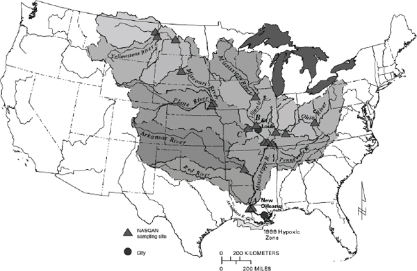
FIGURE 2-1 Mississippi River drainage basin.
SOURCE: Goolsby and Battaglin, 2001.
while the Indus and Volga rivers have deltas comparably the same size as the lower Mississippi.
Similarly, the climatic water budget in coastal Louisiana is characterized by 5 months that have a rough equilibrium between precipitation and evapotranspiration, with 7 months of surplus precipitation and runoff. This is analogous with a small number of other large, subtropical river basins, located primarily in East Asia, although as will be discussed further, construction of analogies can be based upon partial similarities and differences between deltas.
Sediment Mass Balance
The morphology of the Mississippi River delta reflects a balance between supply of sediment from the upstream catchment and erosion and redistribution of sediments by coastal processes. Over the twentieth century, the sediment supply to the Mississippi River delta has decreased from about 400 million metric tons per year to about 145 million metric tons per year because of upstream dams, erosion control, and channel engineering works (Meade and Moody, 2010). A large portion of the reduced sediment volume delivery to coastal Louisiana can be attributed to structures built on the Missouri River, which was a broad, shallow, geomorphologically-active
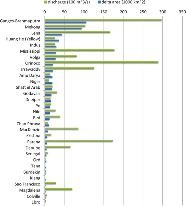
FIGURE 2-2 Some major river deltas ranked by delta area.
SOURCE: World Delta Database, contributions by Coleman and Huh, 2004.
channel before construction of six large mainstem multipurpose reservoirs in the 1930s to 1960s, along with hundreds of miles of river training structures below the downstream mainstem dam at Gavins Point. The dams and river control and bank stabilization structures were built by the U.S. Army Corps of Engineers (NRC, 2011a). Alteration of sediment mass balance along the Missouri River is a major factor leading to the coastal retreat documented in recent decades.
Within the lower Mississippi basin, an important human-induced alteration is the prevention of distributary channel avulsion, channel breakouts,
and spreading of sediment-charged floodwaters across the deltaic plain. To maintain existing navigation, the flow of the Mississippi is constricted within the current “birds-foot” channel outlet to the Gulf. This constraint has the effect of preventing the reduced sediment load still carried by the river from depositing on the deltaic plain between distributary channels. A large portion of the river’s sediment load is directed into the deep waters of the Gulf, where it cannot contribute to maintaining the coastal delta.
Syvitski et al. (2009) estimate a 48 percent reduction in sediment delivery for the Mississippi River delta over the twentieth century, which is comparable with loss of sediment supply to deltas in Europe and South Asia (Table 2-1). For the Mississippi, the loss corresponds to a reduction of delta aggradation from 2 mm/yr in the twentieth century to 0.3 mm/yr in the early twenty-first century. Interestingly, Table 2-1 indicates that the percent reduction in distributary channels of the Mississippi delta is “unknown.”
Subsidence
Subsidence refers to a lowering of the elevation of the ground surface, usually relative to historical mean sea level or similar datum. Subsidence can occur from natural or anthropogenic mechanisms, or as commonly is the case in deltas, from a combination of the two. Natural mechanisms in coastal areas include isostatic adjustments, sediment compaction, adjustments of deltaic landforms in response to crustal loading and compaction of accumulated sediments, and tectonics. Anthropogenic causes of subsidence are typically from resource extraction (e.g., groundwater or oil and gas), which allows deep strata to compact; reduced sediment loads from the river basin upstream (often due to trapping of sediment behind dams), which reduces the rate at which fresh sediment deposition can compensate for subsidence; and wetland drainage, which exposes organic material in soil to the atmosphere, leading to increased rates of oxidative weathering and soil decomposition.
The relative significance of these processes is part of an ongoing debate regarding river deltas around the world (Vermaat and Eleveld, 2013). A qualitative comparison of 10 deltas by the Delta Alliance, an international knowledge network based in Wageningen in the Netherlands, indicates that only the California Bay Delta and Chiliwung have a severity of subsidence comparable to that of the Mississippi (Table 2-2).
A map of projected subsidence ranges for southern Louisiana (Figure 2-3) shows the greatest subsidence rates in the southern part of the delta. Many of the factors described above are at work in the Mississippi Delta (Reed and Yuill, 2009), and many prior studies have emphasized the role of oil and gas extraction and reduced sediment delivery from the river basin upstream (e.g., NRC, 2006). However, outside of geological circles, it ap-
TABLE 2-1 Delta Database with Key Environmental Data
| Delta | Area < 2 mabove sea level (km2) | Storm-surgearea (km2) * | Recent area of insituflooding (km2) | Recent area of insituflooding (km2) | Sediment reduction (%) | Floodplain or delta flow dilversion | Distributary hannel reduction (%) | Subsurface water, oil and gas mining | Early-twentienth-century aggradation | Twenty-frist-century aggradation rate (mm yr1) | Relativesea-level rise (mm yr1) |
| Deltas not at risk: aggradation rates unchanged, minimal anthropogenic subsidence | |||||||||||
| Amazon, Brazil | 1960† | 0; LP | 0 | 9,340 | 0 | No | 0 | 0 | 0.4 | 0.4 | Unknown |
| Congo‡, DRC | 460 | 0; LP | 0 | 0 | 20 | No | 0 | 0 | 0.2 | 0.2 | Unknown |
| Fly, Papua New | 70† | 0; MP | 140 | 280 | 0 | No | 0 | 0 | 5 | 5 | 0.5 |
| Guinea | |||||||||||
| Orinoco, Venezuela | 1,800† | 0; MP | 3,560 | 3,600 | 0 | No | 0 | Unknown | 1.3 | 1.3 | 0.8-3 |
| Mahaka, Borneo | 300 | 0; LP | 0 | 370 | 0 | No | Unknown | 0 | 0.2 | 0.2 | Unknown |
| Deltas at risk: reduction in aggradation, but rates still exceed relative sea-level rise | |||||||||||
| Amur, Russia | 1,250 | 0; LP | 0 | 0 | 0 | No | 0 | 0 | 2 | 1.1 | 1 |
| Danube, Romania | 3,670 | 1,050 | 2,100 | 840 | 63 | Yes | 0 | Minor | 3 | 1 | 1.2 |
| Han, Korea | 70 | 60 | 60 | 0 | 27 | No | 0 | 0 | 3 | 2 | 0.6 |
| Limpopo, | 150 | 120 | 200 | 0 | 30 | No | 0 | 0 | 7 | 5 | 0.3 |
| Mozambique | |||||||||||
| Deltas at greater risk: reduction in aggradation where rates no longer exceed relative sea-level rise | |||||||||||
| Brahmani, India | 640 | 1,100 | 3,380 | 1,580 | 50 | Yes | 0 | Major | 2 | 1 | 1.3 |
| Godavari, India | 170 | 660 | 220 | 1,100 | 40 | Yes | 0 | Major | 7 | 2 | ~3 |
| Indus, Pakistan | 4,750 | 3,390 | 680 | 1,700 | 80 | Yes | 80 | Minor | 8 | 1 | >1.1 |
| Mahanadi, India | 150 | 1,480 | 2,060 | 1,770 | 74 | Yes | 40 | Moderate | 2 | 0.3 | 1.3 |
| Parana, Argentina | 3,600 | 0; LP | 5,190 | 2,600 | 60 | No | Unknown | Unknown | 2 | 0.5 | 2-3 |
| Vistula, Poland | 1,490 | 0; LP | 200 | 0 | 20 | Yes | 75 | Unknown | 1.1 | 0 | 1.8 |
| Deltas in peril: reduction in aggradation plus accelerated compaction overwhelming rates of global sea-level rise | |||||||||||
| Ganges*, Bangladesh | 6,170'" | 10,500 | 52,800 | 42,300 | 30 | Yes | 37 | Major | 3 | 2 | 8-18 |
| Irrawaddy, Myanmar | 1,100 | 15,000 | 7,600 | 6,100 | 30 | No | 20 | Moderate | 2 | 1.4 | 3.4-6 |
| Magdalena, Colombia | 790 | 1,120 | 750 | 750 | 0 | Yes | 70 | Moderate | 6 | 3 | 5.3-6.6 |
| Mekong, Vietnam | 20,900 | 9,800 | 36,750 | 17,100 | 12 | No | 0 | Moderate | 0.5 | 0.4 | 6 |
| Mississippi, USA | 7,140* | 13,500 | 0 | 11,600 | 48 | Yes | Unknown | Major | 2 | 0.3 | 5-25 |
| Niger, Nigeria | 350' | 1,700 | 2,570 | 3,400 | 50 | No | 30 | Major | 0.6 | 0.3 | 7-32 |
| Tigris*, Iraq | 9,700 | 1,730 | 770 | 960 | 50 | Yes | 38 | Major | 4 | 2 | 4-5 |
| Deltas in greater peril: virtually no aggradation and/or very high accelerated compaction | |||||||||||
| Chao Phraya, Thailand | 1,780 | 800 | 4,000 | 1,600 | 85 | Yes | 30 | Major | 0.2 | 0 | 13-150 |
| Colorado, Mexico | 700 | 0; MP | 0 | 0 | 100 | Yes | 0 | Major | 34 | 0 | 2-5 |
| Krishna, India | 250 | 840 | 1,160 | 740 | 94 | Yes | 0 | Major | 7 | 0.4 | -3 |
| Nile, Egypt | 9,440 | 0; LP | 0 | 0 | 98 | Yes | 75 | Major | 1.3 | 0 | 4.8 |
| Pearl*, China | 3,720 | 1,040 | 2,600 | 520 | 67 | Yes | 0 | Moderate | 3 | 0.5 | 7.5 |
| Po, Italy | 630 | 0; LP | 0 | 320 | 50 | No | 40 | Major | 3 | 0 | 4-60 |
| Rhone, France | 1,140 | 0; LP | 920 | 0 | 30 | No | 40 | Minor | 7 | 1 | 2-6 |
| Sao Francisco, Brazil | 80 | 0; LP | 0 | 0 | 70 | Yes | 0 | Minor | 2 | 0.2 | 3-10 |
| Tone*, Japan | 410 | 220 | 0 | 160 | 30 | Yes | § | Major | 4 | 0 | >10 |
| Yangtze*, China | 7,080 | 6,700 | 3,330 | 6,670 | 70 | Yes | 0 | Major | 1.1 | 0 | 3-28 |
| Yellow*, China | 3,420 | 1,430 | 0 | 0 | 90 | Yes | 80 | Major | 49 | 0 | 8-23 |
* LP, little potential, MP, moderate potential; SP, significant potential
† Significant canopy cover renders these SRTM elevation estirnatesconservative.
‡ Alternative names: Congo and Zaire; Ganges and Ganges-Brahmaputra; Pearl and Zhujiang; Tigris and Tigris-Euphrates and Shattal Arab; Tone and Edo; Yangtze and Changjiang; Yellow and Huanghe.
NOTE: Storm surge, river (distributary) channel, and precipitation (in situ) flooding are from MODIS satellite data since 2000. The level of sediment-load reduction is across the twentieth century, as is the reduction in distributary and subsurface mining. Rates of relative sea-level rise are time-variable and the ranges provided cover either different times or different areas of a delta.
SOURCE: Syvitski et al., 2009.
TABLE 2-2 Comparison of Subsidence in the Delta Alliance Comparative Study
| Demographic trends | Economic developments | Technological developments | Climate change | Subsidence | |
| Nile | ••• | •• | •• | ••• | •• |
| Incomati | • | •••• | •• | ••• | • |
| Ganges-Bra hmaputra-Meghna | •• | ••• | •• | •••• | •• |
| Yangtze | ••• | •••• | •• | •• | •• |
| Ciliwung | •••• | ••• | •• | •• | •• |
| Mekong | •• | •••• | •• | ••• | •• |
| Rhine-Meuse | • | •• | ••• | •• | •• |
| Danube | • | • | • | •• | • |
| California Bay-Delta | •• | •• | •• | ••• | •••• |
| Mississippi River Delta | • | •• | ••• | ••• | ••• |
• minimal impacts, now and in the near future (around 10 years)
•• small impacts
••• medium impacts
•••• severe impacts
SOURCE: Bucks et al., 2010.
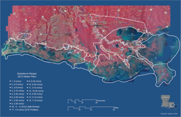
FIGURE 2-3 Map of projected subsidence ranges for south Louisiana generated by the Subsidence Advisory Panel for the Louisiana CPRA Master Plan 2012 Update, following a meeting on October 14, 2010.
SOURCE: CPRA, 2010.
pears there has been less recognition of the underlying geological processes of delta deposition and adjustment, in which important growth faults exert a strong influence on subsidence rates.
Nutrient Balances
Nutrients are essential building blocks that support biological production in the environment. The availability of the major macronutrients, nitrogen and phosphorus, often limits biological production in aquatic systems. In shallow coastal regions, however, these nutrients may be present at high levels due to nutrient inputs from agricultural runoff, sewage or septic inputs, industrial activity, and general development. High nutrient levels drive eutrophication and degrade water quality and may threaten coastal environments, especially large deltas like the Mississippi (Rabalais and Turner, 2006).
In general, nutrients are not the only chemical constituent used to define water quality; rather, it is commonly defined by the concentration of chemical (e.g. dissolved oxygen, plant nutrients, toxins, etc.) and biological (e.g., coliform bacteria) components. In the Mississippi River delta, the concentration and flux of inorganic nitrogen are often key drivers of coastal water quality as high nitrogen fluxes lead to increased plant productivity and biomass, stimulation of noxious algal species, increased rates of organic matter deposition, and, ultimately, hypoxia. Hypoxia leads to habitat degradation and may have negative consequences for Gulf coastal fisheries (Figure 2-4). This cascade of consequences has occurred in the Mississippi River delta region, as well as in other coastal ecosystems across the globe (Figure 2-5; also see Zhao et al., 2012).
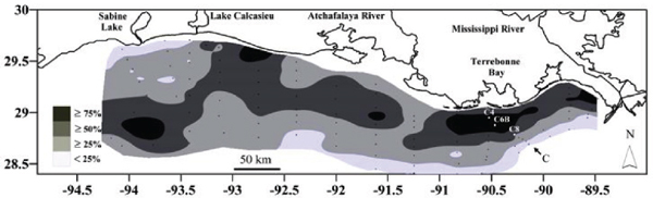
FIGURE 2-4 Frequency of midsummer hypoxia along coastal Louisiana.
SOURCE: Modified from Rabalais et al., 2007.
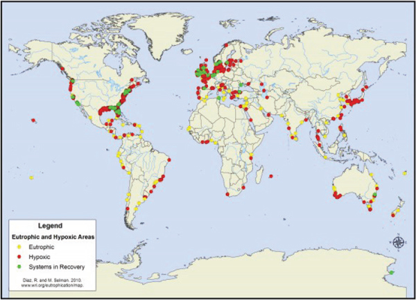
FIGURE 2-5 World hypoxic and eutrophic coastal areas.
SOURCE: WRI, 2010.
Salinity Dynamics
Coastal and delta ecosystems are the meeting place for fresh- and saltwater. The brackish mixing zones in deltas and estuaries are critical within the life cycles of many oceanic species, often providing spawning grounds or juvenile refuge. The distribution and activity of plants, animals, and microorganisms respond to changes in salinity; thus, factors altering salinity distributions are major regulators of coastal ecosystem dynamics. Increased salinity alters plant distributions and can stimulate microbial metabolism in marsh soils, leading to increased respiration rates (Weston et al., 2006). Sea level rise coupled with land subsidence represents a stressor of coastal ecosystems through changes in salinity dynamics that cascade from physical alterations in the range and distribution of water depths. The variability of salinity at any location is affected by the freshwater available, the marsh plants that constrain flow conditions and remove freshwater through evapotranspiration, and water depth. Increasing salinities can have a direct effect on viability of species with limited salinity ranges (e.g., oysters), and indirectly by increasing frequency of hypoxia. In the absence of wind or strong water currents, lighter freshwater flows over the top of denser salt-
water creating stratification that can impede oxygen replenishment and lead to hypoxia at the benthos. Such layers might be thin and episodic (Hodges et al., 2011), but nevertheless impact the benthic ecosystem (Montagna and Ritter, 2006). Wind and strong water currents serve to break down stratification and replenish benthic oxygen levels, but deeper water requires more energy to ensure complete mixing. Thus, changes in water depths in the Mississippi River delta and along the Louisiana coast are likely to alter existing relationships between salinity gradients, mixing, and oxygen replenishment. Water withdrawals, as well as reduced flood peaks (e.g., due to upstream dams and flood control operations), also would further reduce mixing and lead to increased salinities in the coastal zone.
Salts in windborne spray from breaking waves also are transported inland by winds, affecting soil salinity. The response of coupled biogeochemical processes in coastal systems to changes in salinity is not fully understood but, clearly, maintaining stable salinity patterns is critical for sustenance of productive coastal ecosystems. Salinity dynamics and associated resource management challenges in the Louisiana delta may be compared and contrasted with those of other deltas, such as the Bengal and Mekong regions (USGS, 2013). Saltwater intrusion is even more severe in arid irrigated basins and deltas of the Colorado, Indus, and Nile rivers.
Flood Mitigation and Hurricane Protection
Southern Louisiana is subjected to the hydrologic hazards of both lower Mississippi River flooding and Gulf of Mexico hurricanes. Water-related natural hazards have had profound effects in shaping landforms, and development patterns, across southern Louisiana. From the great Mississippi River flood of 1927 and its lasting impacts on the region and nation (see Barry, 1997), to the devastation of Hurricane Katrina in 2005, the region has been the site of some of the nation’s most damaging and disruptive floods and hurricanes.
Following the 1927 Mississippi River flood, the U.S. Congress passed the 1928 Flood Control Act that authorized the Mississippi River and Tributaries (MR & T) project. Responsibility for developing and implementing the project was assigned to the Mississippi River Commission. The MR & T has four major elements: (1) levees for containing flood flows; (2) floodways to pass excess flows past critical reaches of the Mississippi River, and around communities and valuable infrastructure; (3) channel improvement and stabilization activities to ensure a reliable navigation channel, increase the river’s flood-carrying capacity, and protect the levee system; and (4) tributary basin improvements, such as dams, reservoirs, and pumping plants and stations (USACE, 2013a). The MR & T is the largest flood control project in the world. It includes huge mainstem levees along
the lower Mississippi River that provide levels of flood protection for Baton Rouge, New Orleans, and other communities along the river.
The MR & T project has had extensive and profound effects on lower Mississippi River, and Atchafalaya River, hydrology. The project, via the Old River Control Structure located near Simmesport, Louisiana, diverts 30 percent of Mississippi River discharge into the Atchafalaya River and valley. The project’s flood control levees inhibit distribution of sediments in high water into extensive floodplain areas. It also must be noted that the MR & T system has performed well during periods of high river flows; in 2011, for example, during extremely high Mississippi River flows, the system performed much as had been envisioned decades ago.
Regarding threats from hurricanes and related storm surge, the primary means for structural protection is the Greater New Orleans Hurricane and Storm Damage Risk Reduction System. There is a long, complex, and interesting history of multiple federal authorizations for the construction of various segments of this system across the New Orleans region (see Woolley and Shabman, 2008). Significant federal planning—including Corps of Engineers’ design proposals and congressional authorizations—for hurricane protection for New Orleans and the surrounding metropolitan areas date back to the 1950s, when the Corps began studies for the Lake Pontchartrain and Vicinity Hurricane Protection Project. This history of hurricane project development includes changes in preferences for Corps plans; lawsuits and injunctions; complex relations and relative responsibilities between the Corps, the state of Louisiana, and levee districts and other parish-level entities; and hurricanes that changed perceptions of the system and protection (notably Hurricane Betsy in 1965).
Hurricane Katrina in late August 2005 exposed the flaws and inadequacies in the historical development of New Orleans hurricane protection. In Katrina’s aftermath, the U.S. Department of the Army established the Interagency Performance Evaluation Task Force (IPET) to assess the system’s performance during Katrina. The IPET evaluation produced numerous reports in its existence from 2005 to 2008. Among its many conclusions, it stated that the hurricane protection system “… did not perform as a system,” that the system was constructed “in many separate steps over a long period of time” and represented a history of “continuous incompleteness” (IPET, 2008).
Following Katrina, over 10 billion federal dollars were invested in New Orleans’ hurricane and flood protection system, including repairs and strengthening on hundreds of miles of levees, walls, and gates. Since Hurricane Katrina (and Rita) in 2005, there has been renewed national-level interest in southern Louisiana and Gulf hurricane and storm surge protection, and in ways in which levees, sea walls, population resettlement, evacuation, floodproofing, and landscape restoration might be better
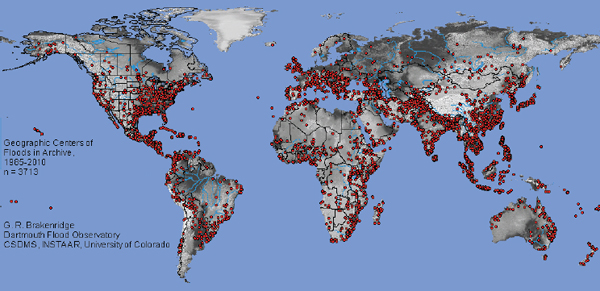
FIGURE 2-6 Geographic centers of flood events, 1985-2010.
SOURCE: Dartmouth Flood Observatory, 2010.
integrated to reduce the region’s exposure and vulnerability (NRC, 2009; RAND, 2011). From a global perspective, the distribution of flood losses and flood control efforts is shaped by population density and land development in major floodplains and coastal areas. These hazards generally have their most destructive effects in the major deltas of Asia (Figure 2-6). Centers with information that compare international flood events, losses, and trends include the maps and records of the University of Colorado’s Dartmouth Flood Observatory2 (Figure 2-6; NASA’s near real-time flood mapping imagery,3 and the Center for Research on the Epidemiology of Disasters EMDAT database.4
Deltas that experience large numbers of tropical cyclones provide comparisons with the Mississippi River delta (e.g., as mapped by the Joint Typhoon Warning Center; NASA; NOAA; and others). Global historical tropical storm tracks (Figure 2-7) indicate that partial analogues to the Mississippi delta can be found in East, Southeast, and South Asia. The analogues are partial because storm risk also depends upon bathymetry, tidal range, and coastal population and infrastructure at risk (e.g., Brakenridge et al., 2013). Tropical storms prompt questions about the current degree of vulnerability for human populations, infrastructure, settlement patterns, and commerce.
______________
2 See http://floodobservatory.colorado.edu.
3 See http://oas.gsfc.nasa.gov/floodmap/index.html.
4 See http://www.emdat.be.
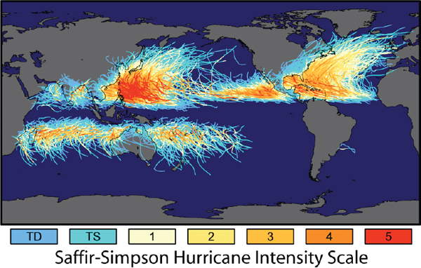
FIGURE 2-7 Tracks and intensity of all tropical storms.
NOTE: TD: tropical depression. TS: tropical storm.
SOURCE: NASA, 2013.
Climate Change and Sea Level Rise
Climate change and accelerated sea level rise are chronic phenomena that exacerbate natural forcing functions. Hydrologic alterations, such as droughts, floods, and large storms (hurricanes, nor’easters), can lead to rapid change in coastal zones, including exacerbation of coastal erosion (Pijnappels et al., 2010). Regional or global shifts in climate may occur over the indefinite future and affect environmental and social processes in the Gulf delta and coastal regions. Linkages between regional environmental change and global climate change are distinctive in that they are likely to be manifested only gradually, as compared with other types of change mentioned above, and because their effects are masked over short intervals by local or regional climate variability. The topics of nonstationarity and its implications for climate and hydrologic systems, and water management and decision making, have widespread implications and attract extensive scientific and public policy interest (see Colorado Water Institute, 2010).
Regarding the implications of sea level rise, changes in climate may affect sea level rise globally; but there may be regional differences in sea level rise, as well, because of differences in geologic factors such as subsidence and tectonics, which raise or lower coastal land masses and landforms.
Large-scale climate variations, such as El Niño and the Pacific Decadal Oscillation, also raise or lower regional sea level height (NRC, 2012). Increasing sea level heights would have definable consequences for the coastal zone, including vulnerability of human populations to storms or floods. Figure 2-8 illustrates sea level rise predictions along U.S. coastal areas, with the highest predicted rates for the Louisiana and Texas gulf coasts, while Figure 2-9 illustrates global sea level rise estimates.
Significant regional changes in other aspects of climate could occur, but are difficult to anticipate and especially difficult to translate into specific effects and adaptation plans in the Gulf Coast environment (cf. Van der Most, 2009). An assessment from the Intergovernmental Panel on Climate Change of global coastal vulnerability to sea level rise put the Mississippi delta in the “high” but not “extreme” category of population displacement related to an estimated eustatic (worldwide, uniform change) sea level rise of 5-7 mm/yr and the Mississippi delta’s relatively low population density indicate 5-25 mm/yr (Figure 2-10; Ericson, Vörösmarty et al., 2006; Nicholls et al., 2007; Syvitski et al., 2009). Other deltas in the same category are the Godavari delta in India, Changjiang delta in China, Niger in Nigeria, and Shatt al Arab in Iraq. Analogues in the more “extreme” category are the Ganges-Brahmaputra and Mekong.
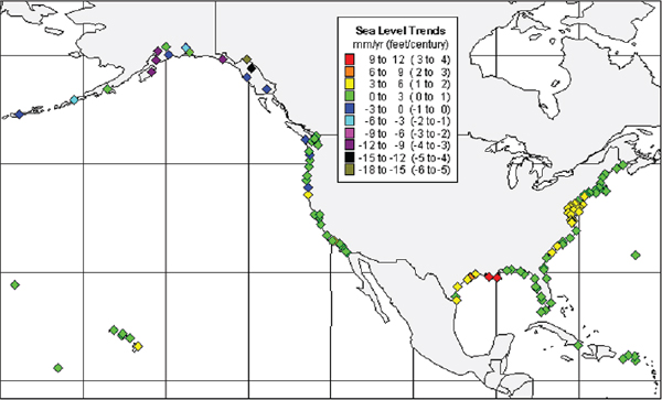
FIGURE 2-8 Regional mean sea level trends.
SOURCE: NOAA, 2013.
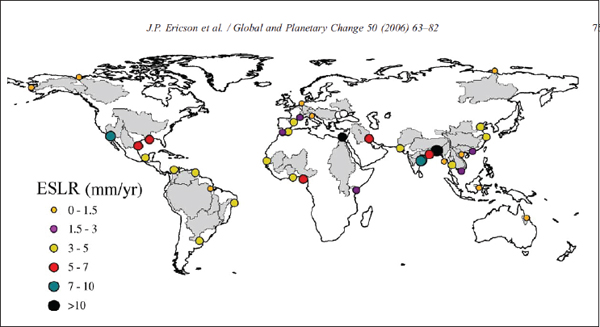
FIGURE 2-9 Global distribution of estimated seal level rise (ESLR) under baseline conditions for 40 deltas.
SOURCE: Ericson, Vörösmarty et al., 2006.
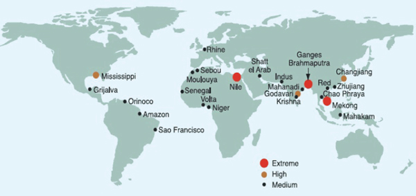
FIGURE 2-10 Relative vulnerability of coastal deltas as shown by the population potentially displaced by current sea-level trends to 2050 (Extreme = >1 million people displaced; High = 1 million to 50,000; Medium = 50,000 to 5,000).
SOURCE: Nicholls et al., 2007.
Commercial Navigation and Dredging
Commercial navigation on the lower Mississippi River is one of the region’s important and vital economic sectors, which also has great national economic significance. Some 6,000 vessels and 300 million tons of cargo
travel up and down the Mississippi River each year, including over half of the nation’s grain exports. In 2010, more than 10,000 vessels transited South Pass, one of the three branches of the mouth of the Mississippi River (Lorino, 2011).
The Ports of New Orleans, South Louisana, Plaquemines, and Baton Rouge are four of the top 13 U.S. ports based on volume of cargo handled (U.S. DOT, 2013). The Ports of New Orleans and south Louisiana together form one of the world’s largest port systems in terms of bulk tonnage. The Port of New Orleans is served by six major railroads, more than any port in the United States. Port of New Orleans facilities include over 204 hectares of cargo-handling areas and more than 12 hectares of covered storage, and its Henry Clay Avenue and Milan Street terminals are served by the world’s longest wharf (Port of New Orleans, 2013).
Historically, the U.S. Army Corps of Engineers has dredged the river to depths that allow vessels with greater than 45-foot drafts to navigate the river’s passes into and out of the river. Sufficient draft depth to support commercial navigation clearly is an issue of great importance to commercial navigation, and any proposals that the Corps of Engineers might reduce its dredging activities along the lower river are of great concern to the shipping industry (see Ryan, T.P., 2012). Commercial navigation interests also have concerns about the potential effects of proposed diversions along the lower Mississippi River to enhance wetlands creation (as proposed in the Louisiana 2012 Coastal Master Plan). Dredging in the lower Mississippi River creates preferential deep-water paths for freshwater to rapidly enter the Gulf of Mexico, whereas diversions attempt to spread freshwater over broader areas. Diversions thus could negatively affect the commercial navigation sector, if diverted flows either affect river water levels (reducing available ship draft) or induce shoaling within the river downstream of the diversion. Interactions between diversions, and resulting changes in sediment delivery and deposition, are of critical importance given the economic prominence and value of the shipping industry, barge operators, pilots associations, and the energy industry.
A harbinger of possible tensions between navigation and diversions is the West Bay Diversion, which is a human-made opening on the west side of the Mississippi River south of Venice, Louisiana, and 4.7 miles above Head of Passes. This diversion was designed to create 9,832 acres of wetlands over a 20-year project life, by allowing 20,000 cubic feet per second of river water to flow into West Bay (Louisiana Coastal Wetlands Conservation and Restoration Task Force, 2013). The wetland creation project was funded by the U.S. federal Coastal Wetlands Planning, Protection, and Restoration Act (CWPPRA) of 1990.
After wetland project construction in 2003, the anchorage at Pilottown, Louisiana required dredging, leading some to conclude that the diversion
caused river shoaling. Concerns about ongoing dredging costs almost led to closure of the diversion, which would have been a strong indication that navigational interests trump restoration. However, the Corps of Engineers showed that only 25 percent of the dredging is a result of the diversion; therefore, dredging costs attributable to the diversion were lower than expected, and the diversion continues to create land.
Land Development—Rural, Industrial, Residential, and Urban
Although not as densely populated as some large river deltas around the world, the Mississippi River Delta is home to an impressive concentration of industrial and navigational infrastructure, the maintenance of which largely motivates efforts to preserve the status quo of the current birds’ foot delta mouth and petroleum industry logistics centers, such as Port Fouchon. With the pressure of increased population, large areas—especially contiguous with New Orleans—have been developed for housing and commercial uses, mostly low-lying “back swamp” areas that were considered uninhabitable before the advent of powerful pumps capable of draining the land (Campanella, 2002). Once areas are settled, the presence of the populations there creates pressure to build levees, and over time, more and larger levees, which in turn can encourage more development, and the larger populations at risk can then increase the demand for structural protection (White, 1945; Werner and McNamara, 2007).
Settlement patterns and commercial use of coastal lands, including marshes, create social interests that lead to support for or opposition to environmental management. Examples include support for specific flood control or sediment augmentation plans motivated by a desire to preserve property, and opposition to the same kinds of plans on grounds of expected reduction of land values or impairment in harvest of fish or shellfish. The long-term record of settlement and urbanization has fascinating trajectories, particularly in the New Orleans metropolitan area, which has experienced population loss, postdisaster redevelopment, and wider changes in urbanism in recent years (Colten et al., 2008; Campanella, 2010). Comparative social sciences research is also useful for assessing the vulnerability of different social groups (Slack et al., 2009).
Energy and Petrochemical Development and Operations
Oil and gas development in the Gulf region began over a century ago. It expanded rapidly in the Mississippi River delta during the third quarter of the twentieth century, after which oil production moved increasingly offshore, while significant gas production in the delta continues (Figures 2-11 and 2-12). Legacy channels, pipeline aging, and associated hazards
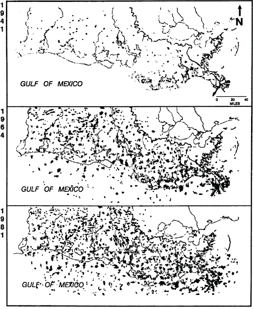
FIGURE 2-11 Oil and gas fields in southern Louisiana in 1941, 1964, and 1981.
SOURCE: Turner, 1987.
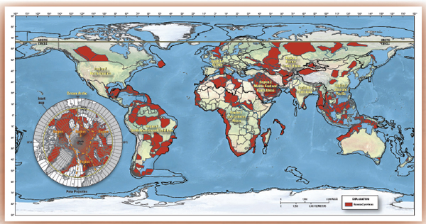
FIGURE 2-12 Estimates of undiscovered conventional oil and gas resources of the world, fact sheet 2012-3028.
SOURCE: Schenk, 2012.
remain. The infrastructure and operations of the energy industry in the Gulf region affect environmental resources through channelization and diking, which affect routing of water and sediment within wetlands. Pipeline and extraction channels disrupt water flow and accelerate erosion, while pumping increases rates of local subsidence. Changes in standard practice and remediation measures following the construction phase of energy extraction have the potential to restore natural features of marsh affected by routine operations that follow construction.
Many deltas in other regions of the world have oil and gas production. One of the largest and arguably most problematic cases is the Niger delta where environmental contamination and conflict have escalated. The Orinoco and Nile deltas have deltaic oil production, as do offshore areas in the north Indian Ocean and Arctic Sea. As in the Mississippi, production in some of these regions is moving from coastal to offshore fields.
Fisheries and Biodiversity
Fish and shellfish habitat and abundance depend upon all of the agents of change discussed above. Yields from the Gulf delta region are monitored and regulated in an attempt to ensure sustained yield. Environmental impairment caused by the Deepwater Horizon oil spill, multiple severe storms, and gradual loss of habitat can be expected to reduce optimum yield of commercially important species. To plan for habitat conservation and restoration projects, the Louisiana 2012 Coastal Master Plan commissioned 14 habitat suitability index reports for species of commercial, sport, and ecological interest that included American alligator, crawfish, eastern oyster, brown and white shrimp, largemouth bass and spotted sea trout, otter, muskrat, and several species of waterfowl (CPRA, 2012, apps. D5-D18).
Worldwide, deltas are valued for their biological diversity and estuarine ecological services (Day et al., 2012). The Danube delta stands out as a region that has been formally protected as a biosphere reserve and United Nations Economic, Scientific, and Cultural Organization (UNESCO) World Heritage Site of “outstanding universal value” since the early 1990s. It includes lands in Romania, Ukraine, and Moldova. It has been described as Europe’s best-preserved delta (UNESCO, 2013), and it also has been noted for progress made in rules for navigation dredging and restoration, and architecture and building activities. The Sundarbans mangrove forest of Bangladesh and India is another major international deltaic region listed as a UNESCO World Heritage Site.5 UNESCO has raised concerns about the infrastructure for ecological monitoring and protection, which may be
______________
5 For more information, see: http://whc.unesco.org/en/list/798/; and: http://whc.unesco.org/en/list/452.
an opportunity for collaborative international research. Finally, the U.S. Geological Survey DRAGON (2013) program has initiated a collaborative fisheries project in the Mekong basin that provides an analogue with the Mississippi River delta.
Water Management Institutions
It may seem unusual to regard water management institutions as agents of change, but they guide infrastructure development and natural resources use in ways that have human and environmental consquences in lower riparian and deltaic regions. Institutions, broadly defined, include water laws, policies, and organizations, along with the social practices through which they operate (Ingram et al., 1984). They are designed to have certain effects on water and related land resources; and to avoid, mitigate, or correct others (Ostrom, 1990). To be effective in any of these ways, water management institutions require legitimacy and are to be implemented by the societies that create and modify them. The effects of diverse water institutions may complement or conflict with one another. The absence of water institutions also has impacts (Galloway, 2011). Thus, the nature and roles of institutional diversity, dynamics, and change play important roles in complex environmental systems (Ostrom, 2005).
To be more specific about effects of water institutions in deltaic areas, it is important to understand how they respond to biogeophysical agents of change, such as floods and hurricanes, with greater or lesser degrees of effectiveness and sustainability. Timely institutional response to environmental change, extreme events, and slow-onset hazards (such as drought) in deltaic regions requires nonstructural institutions that enhance preparedness, warning, and evacuation, as well as structural measures of adjustment (Glantz, 1999; White, 1945). The history of the Mississippi River delta development and management also underscores the importance of effective relationships between specific water institutions and broader governance structures.
Governance includes social roles and responsibilities, including private and nongovernmental actors who affect the structure and processes of deltaic water, land, and environmental management. Governance shapes and is shaped by major social trends from privatization to participation, risk behavior, decentralization, and globalization. Although institutional and governance research have expanded recently in the fields of water and environmental management, they may be less mainstreamed in Mississippi River delta research than in the Rhine-Meuse delta and other regions (Table 2-3). Over the course of centuries, Dutch water boards (watershappen) have consolidated from several thousand down to the current 25 (Unie
TABLE 2-3 Comparative Overview of Scorecards of the 10 Deltas Studied, Including Governance Scores
| Land and water use (occupation layer) | Infra-structre (network layer) | Natural Resources (base layer) | Governance | Resilience & Sustainability Indicator | |||
| Current | Moderate Scenario | Extreme scenario | |||||
| Nile delta | -- | 0 | - | 0 | - | - | -- |
| Incomati delta | 0 | - | - | - | - | - | -- |
| Ganges-Brahmaputra-Meghna delta | -- | -- | -- | 0 | -- | - | -- |
| Yangtze delta | - | + | - | 0 | 0 | 0 | -- |
| Ciliwung delta | -- | -- | -- | - | -- | -- | - |
| Mekong delta | 0 | 0 | - | 0 | 0 | + | 0 |
| Rhine-Meuse delta | + | ++ | 0 | + | + | 0 | - |
| Danube delta | + | + | + | 0 | + | 0 | 0 |
| California Bay-delta | 0 | - | - | 0 | - | 0 | - |
| Mississippi Rever delta | 0 | 0 | - | 0 | - | 0 | - |
resilience/sustainability: ++(very good), + (good), 0 (medium), - (low), -- (very low)
SOURCE: Bucks et al., 2010.
van Waterschappen, 2013). The Delta Alliance 10-deltas study flagged “governance” as a research gap in the Mississippi delta (Bucks et al., 2010).
Cumulative Impacts of Agents of Change: The Example of Deltaic Land Loss
The agents of change discussed above interact with one another and can amplify or offset one another in various environmental processes in lower basin and coastal deltaic regions. A good example is the core concern with deltaic land loss in coastal Louisiana. Many deltaic regions, including the lower Mississippi, face increasing rates of coastal land loss. This land loss may be regarded as the cumulative and joint effect of almost all the agents of change listed above.
Detailed reconstructions of historical processes of land loss in coastal Louisiana indicate and project net losses at differential rates for all but a very few small areas of the coast (Blum and Roberts, 2009). These exceptions are important research areas for understanding land-building processes. International analysis by Ericson, Vörösmarty et al. (2006) estimates future land losses to sea level rise in the Mississippi delta between 2000 and 2050 at almost 20 percent. Two other international deltas with similar
magnitudes of estimated losses are the Godavari in India (22.5 percent) and the Orinoco in Venezuela (21 percent) (Table 2-4).
A SYSTEMS APPROACH TO INTEGRATED WATER AND ENVIRONMENTAL MANAGEMENT
The foregoing overview of environmental agents of change in the Mississippi River delta region and selected international delta analogues indicate that agents of change have cumulative effects. One major challenge for environmental research in the Gulf is to separate and quantify the effects of specific agents of change as a means of providing scientific guidance for remediation and modification of standard practices of human activities in the Delta. However, there are myriad unmet research needs associated with each agent of change, and their coupled nature suggests the advisability of a systems approach to analysis of challenges in the Mississippi delta and other large deltaic regions.
A Human-Environmental Systems Research Approach
The greater challenge for research of practical value is to treat deltas as integrated water and environmental systems. Relevant to this approach was a historical breakthrough in water systems planning in the Harvard Water Program and related efforts in the mid-twentieth century exemplified by the Design of Water Resource Systems (Maass et al., 1962). That work drew together advances in multiobjective water infrastructure planning, economic simulation and optimization models, synthetic hydrology methods, and new computational tools. It was led by a professor of government at Harvard and included institutional and political analysis. It did not include ecosystem modeling or behavioral decision making, but concurrently ecologists such as Eugene and Howard Odum were developing ecological and energy models that were applied specifically to wetland and estuarine systems (Day et al., 2012; Odum, 1969; Odum, 1971). Geographer Gilbert F. White (1945) pioneered behavioral sciences approaches to flood hazards and floodplain settlement. Through these and many other contributions, the Mississippi River valley has been managed in some respects as a human-environmental system (e.g., in 2011 flood operations; Allison et al., 2013). The Louisiana 2012 Coastal Master Plan likewise supports some dimensions of systems-wide management.
The current generation of integrative water and environmental modeling encompasses these ecological, risk, and behavioral processes more fully (e.g., Loucks and Van Beek, 2005; Simonovic, 2009). The next generation of studies likely will advance by incorporating human settlement processes, livelihood strategies, and possibly cultural and technological change. This
TABLE 2-4 Deltaic Population and Areas
| Delia | Population at risk | % delta population at risk | % delta area potentially losl | |||
| Amazon | 69,300 | 1.89 | 2.45 | |||
| Bengal | 3,430,000 | 1.78 | 5.50 | |||
| Burdekin | 24 | 0.28 | 1.33 | |||
| Chao Phraya | 12,300 | 0.01 | 0.34 | |||
| Colorado | 544 | 0.11 | 3.35 | |||
| Danube | 3150 | 2.56 | 4.18 | |||
| Dnepr | 1300 | 5.60 | 7.31 | |||
| Ebro | 470 | 2.00 | 2.19 | |||
| Godavari | 453,000 | 16.2 | 22.5 | |||
| Grijalva | 26,700 | 1.76 | 5.59 | |||
| Hong (Red) | 70,500 | 0.85 | 0.95 | |||
| Indus | 7200 | 0.79 | 2.73 | |||
| Irrawaddy | 866 | 0.01 | 0.03 | |||
| Krishna | 16,900 | 1.92 | 3.42 | |||
| Lena | 0 | 0 | 1.07 | |||
| Mackenzie | 0 | 0 | 5.43 | |||
| Magdalen a | 1980 | 0.07 | 1.97 | |||
| Mahakam | 64,800 | 7.06 | 6.29 | |||
| Mahanadi | 101,900 | 1.73 | 3.51 | |||
| Mekong | 1,910,000 | 6.51 | 5.82 | |||
| Mississippi | 480,000 | 18.5 | 19.9 | |||
| Moulouya | 7470 | 6.49 | 6.46 | |||
| Niger | 59,000 | 0.69 | 3.26 | |||
| Nile | 1,300,000 | 1.53 | 2.08 | |||
| Orinoco | 34,200 | 21.3 | 21.0 | |||
| Parana | 267 | 0.04 | 0.53 | |||
| Po | 312 | 0.65 | 0.80 | |||
| Rhine | 43,900 | 2.04 | 4.00 | |||
| Rhone | 2590 | 2.63 | 5.56 | |||
| Rio Grande | 3930 | 0.13 | 1.69 | |||
| Sao Francisco | 5720 | 9.04 | 11.23 | |||
| Sebou | 7180 | 4.36 | 3.30 | |||
| Senegal | 23,800 | 3.95 | 1.59 | |||
| Shall el Arab | 54,300 | 4.45 | 3.34 | |||
| Tana | 392 | 7.25 | 5.68 | |||
| Volta | 6320 | 1.13 | 1.12 | |||
| Yangtze | 484,000 | 1.07 | 3.17 | |||
| Yellow | 3760 | 0.57 | 1.02 | |||
| Yukon | 31 | 2.06 | 1.98 | |||
| Zhuijiang | 25,500 | 0.20 | 0.39 | |||
| World | 8,710,000 | 2.0 | 4.9 | |||
NOTE: Distribution of the total population potentially impacted, percentage of delta population influenced, and the delta area impacted for each delta under baseline ESLR conditions extended from 2000 through 2050.
SOURCE: Ericson, Vörösmarty et al. (2006).
already is happening to some extent through interdisciplinary research with GIS platforms and coupled environmental and social models. It is also happening through community-based GIScience, citizen-science, and collaborative modeling as will be elaborated in later chapters. Not all systems inquiry involves formal quantitative modeling. For example, there is a valuable legacy of parish coastal zone planning in Louisiana (e.g., Sevier et al., 2000). There also are creative frontiers opening up in studies of “shrinking cities,” such as New Orleans (e.g., Ryan, 2012; Zaninetti and Colten, 2012).
• Each of the agents of change considered in this report has received substantial scientific attention, yet potentially entails numerous unmet research needs. These individual agents of change are highly interdependent. It thus is not possible to fully explain complex problems (e.g., coastal land loss in Louisiana) through research on individual agents alone. Nor is it possible to meaningfully advance integrated water and environmental management through a reductionist approach of the sort often adopted in some scientific investigations and projects, as compared with a systems approach.
• It therefore is important to articulate a “human-environmental systems approach,” grounded in the Mississippi delta base case—and to use that systems approach to seek partial analogues with other large deltas in ways that inform, inspire, and challenge integrated water and environmental management in the lower Mississippi River delta.
Promising International Analogues
This report’s statement of task calls for it to address commonalities between the Mississippi River and other deltas of the world. By starting with a discussion of the lower Mississippi River delta, and the agents of change in the region, this regional setting represents a base case for comparison. In referring to some other river deltas around the world, the Mississippi River delta is situated in a comparative international context, and several potential international analogues are presented. There will be no perfect analogues; all are partial (i.e., useful in selective ways). The value of comparative assessments is not limited to “successes” only. Suboptimal or flawed examples also offer learning opportunities, as do contrasts between the Mississippi River and other deltas.
Venezuela’s Orinoco River, for example, provides an example of a delta or lower river comparison for the Mississippi in that it offers some contrasts with the Mississippi. The lower Orinoco floodplain and delta are sparsely populated and lack significant infrastructure, although petroleum development is planned. The river maintains a delta that is relatively small
compared to the Orinoco discharge; the Mississippi discharge is half that of the Orinoco, but the Orinoco delta is less than half as large as the Mississippi delta (Syvitski et al., 2009). The delta’s modest dimensions are explained at least in part by the small amount of sediment per unit volume in waters of the Orinoco (Lewis and Saunders 1989), which are the lowest of all large global nontributary rivers that reach the ocean. Nutrient concentrations in Orinoco waters are extremely low, as they are unenriched by land use or waste disposal processes. Water passes through the delta mainly by way of two principal distributaries. Many other distributaries exist but are small. Low sediment load per unit volume stabilizes the path of water through the two main distributaries.
The main analogues identified for comparison in this chapter and discussed later in the report include the Rhine (flooding, hazards, management); Danube (environmental management); Mekong (sediment, hazards, fisheries); Ganges-Brahmaputra (flooding; hazards; fisheries); Irrawaddy (hazards, biodiversity); Niger (oil and gas development); and the three major deltas in China (Yellow [Huanghe], Yangtze [Changjiang], and Pearl [Zhujiang]—sediment, urbanization, management). In seeking to inform decision making via international comparisons, it is important to survey a range of possible analogues that offer different lessons and innovations.
• Large deltas of the world vary so greatly that international comparison focused solely on one or a few agents of change are not likely to provide comparisons robust enough to advance the theory and practice of integrated water and environmental resources management in the Mississippi River delta.
• Research on deltaic “analogues” focuses first on a base case, which in this study is the Mississippi River delta. It then may examine specific agents of change by constructing problem-driven partial international analogies, set within a systems framework, to help advance the theory and practice of integrated water and environmental management.


