
3
OPERATIONAL CONSIDERATIONS
Technology
Space-geodetic networks have existed from the early days of space activities. These networks have evolved in their scope, precision, and technologies used since the late 1950s. Mentioned in previous chapters are several global networks using different technologies that were deployed to meet different objectives. In this section, we shall delve into technological aspects in slightly greater detail, examine the geographical distribution of existing sites, and compare briefly the contributions of various techniques. This discussion focuses on techniques used now or expected to be used in the coming years for the very highest precision geodetic applications.
Very Long Baseline Interferometry (VLBI)
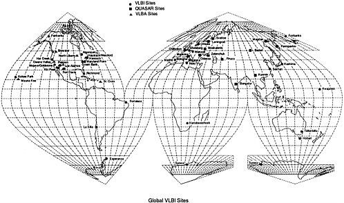
In the VLBI technique, two or more radio antennae simultaneously measure the difference in time of arrival of extragalactic radio sources. In some cases other radio sources, such as satellites, are observed. The difference in arrival time is the fundamental observation from which the geodetic quantities are determined. The extraction of these time differences of arrival usually utilizes recordings of the received signal on high-density media at the various sites over several hours. The data recorded at the various sites are compared pairwise on a correlator, and the differences in arrival time delay are estimated. The primary operational limitation is the mutual visibility of a radio source between a pair of sites. The global fixed VLBI sites in 1990 are shown in Figure 9.
When the radio sources used in VLBI are quasars, the technique has no sensitivity or tie to the Earth's center of mass. If the radio source is a satellite, the satellite's dynamics must be introduced through the adoption or determination of an ephemeris; the center of mass is, therefore, an inherent element of the solution for such cases.
The demonstrated sensitivity of VLBI to geodetic parameters is as follows:
-
Relative site coordinates
The technique requires the adoption of a constraint, such as the selection of one site in a network as the reference; the coordinates of the other sites are determined with respect to the reference (i.e., the baseline vectors).
-
Earth orientation
The technique is sensitive to the direction and magnitude of the Earth's angular velocity vector with respect to the reference frame defined by the adopted reference site coordinates (polar motion). Furthermore, the technique is sensitive to variations in the magnitude of the angular velocity vector (exhibited by length of day and UT1). Finally, because of the observation of extragalactic radio sources in normal VLBI operation, the technique is dependent on phenomena influencing the orientation of the Earth's reference frame relative to the quasar reference frame (i.e., the precession and nutation angles). Figure 10 shows a high-resolution determination of UT1 using VLBI (Herring, 1991).
-
Reference frame
In the common mode of operation in which compact extragalactic radio sources are observed, VLBI is used to establish an extraterrestrial reference frame. In essence, this reference frame is nonrotating.
Since the radio signals pass through the ionosphere, delays of the signals due to both the ionosphere and the atmosphere are important. The ionospheric effect is greatly diminished by measuring group delays at two frequencies (typically S-and X-band). The atmospheric delays depend on both wet and dry components of the neutral atmosphere; the wet component correction may be inferred from water vapor radiometer data. The dry component can be modeled with site measurements of atmospheric pressure, temperature, and humidity. The geodetic estimation using VLBI time delay data usually includes the determination of a set of parameters representing corrections to the models of atmospheric propagation effects.
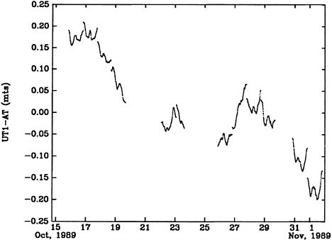
FIGURE 10. Example of high-resolution determination of UT1 variations using VLBI (from Herring, 1991).
Laser Ranging (SLR, LLR, and GLRS)
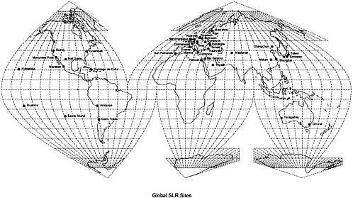
The laser ranging technique is characterized by transmission of a short pulse of laser-emitted energy (usually visible as green light) to a retroreflector (corner cube) target and the detection of photons reflected back to the transmitter by the target. The fundamental measurement is the roundtrip travel time of the pulse. When the target is an artificial satellite and the transmitter is a ground-based instrument, the technique is called Satellite Laser Ranging (SLR). If the target is a retroreflector on the moon, the technique is Lunar Laser Ranging (LLR). Planned for the Earth Observing System in the late 1990s is the Geoscience Laser Ranging System (GLRS), in which the laser is in a satellite and the reflectors are at ground sites. Global SLR sites in 1990 are shown in Figure 11. Both SLR and LLR are used by the IERS to determine components of Earth orientation.
Since the dynamics of a satellite directly affect laser ranging results, the measurements reflect an inherent sensitivity to the location of the center of mass. (Depending on how these measurements are used, however, this sensitivity can be diminished.) Common targets for SLR are given in Table 3 and future targets in Table 4.
Numerous other satellites have been tracked by SLR—the GEOS series, SEASAT, and BE-C, to name a few. These satellites were tracked for various purposes, including precise orbit determination and gravity field applications. Other current targets include GEO-1K, a candidate for gravity field applications, at a 1,500-km altitude.
As illustrated by Table 3 and Table 4, no single satellite target meets the complete range of geodetic needs from reference frame to gravity field, even though laser ranging measurements are sensitive at some level to all of them. Because gravity decreases with altitude, the lower-altitude satellites are more sensitive to field variations and have therefore made the greatest contributions to our knowledge of the gravity field. Thus, in general, the lower-altitude satellites are used for gravity
TABLE 3. Current SLR targets.
|
Satellite |
Altitude (km) |
Application and Comments |
|
Starlette |
800 |
Primary application is gravity field, including temporal variations. Spherical satellite. |
|
Ajisai |
1,300 |
Primary application is gravity field. Spherical satellite. |
|
GEO-1K |
1,500 |
Gravity field applications. |
|
LAGEOS-I |
5,900 |
Adopted satellite for reference frame, crustal motions, Earth rotation, and gravity field (including temporal variations). Spherical satellite. |
|
Etalon-1 |
20,000 |
Primary applications are reference frame and Earth rotation. Spherical satellite. |
|
Etalon-2 |
20,000 |
Primary applications are reference frame and Earth rotation. Spherical satellite. |
TABLE 4. Future SLR Targets. (Other satellites have been proposed—e.g., Lageos-III and ACRE—but are not yet completely funded.)
|
Satellite |
Altitude (km) |
Launch |
Purpose |
|
ERS-1 |
800 |
1991 |
SLR will be used as one of the primary orbit determination systems. Oceanographic satellite with altimeter. Nonspherical satellite. |
|
Stella |
800 |
1992 |
A duplicate of Starlette, but different orbit inclination. Applications to the gravity field, including temporal variations. Spherical satellite. |
|
TOPEX/POSEIDON |
1,300 |
1992 |
SLR will be used as the primary orbit determination system. Oceanographic satellite with altimeter. Nonspherical satellite. |
|
LAGEOS-II |
5,900 |
1992 |
A duplicate of LAGEOS-I, but different orbit inclination. Applications to reference frame, crustal motions, Earth rotation, and gravity field. Spherical satellite. |
field applications (including temporal variations associated with tides, postglacial rebound, etc.), while the higher-altitude satellites are used for reference frame and Earth rotation applications. While it is theoretically possible to use one satellite to determine the gravity field, experience has shown that highly correlated coefficients and geographical distribution of stations will adversely influence such determinations.
In summary, the demonstrated sensitivity of laser ranging techniques to geodetic parameters is as follows:
-
Site coordinates
The coordinates of sites can be established in a reference frame whose origin coincides with the center of mass and in which the longitude of one site has been adopted as reference.
-
Earth orientation
The technique is sensitive to the direction and magnitude of the Earth's angular velocity vector with respect to the adopted or determined reference frame. However, the ability to separate variations in the angular velocity vector (e.g., UT1) and precession/nutation from other characteristics depends on the satellite used. For example, LAGEOS is used to determine UT1 variations with periods less than about 60 days, but because of similar signals associated with tides it is limited in its application at longer periods and for nutation studies. Ranging to the moon, on the other hand, is sensitive to the full range of Earth orientation parameters.
-
Inertial orientation
Only high satellite ranging, especially LLR, is adequately sensitive to an inertial frame defined by the orbital characteristics of the Earth about the sun. There is no direct sensitivity to the quasar reference frame, only an indirect link through common terrestrial sites of laser ranging and VLBI.
As with other space-geodetic techniques, laser ranging signals pass through the atmosphere and propagation effects occur. The spread of laser pulses is essentially independent of ionospheric effects, but the influence of the dry component of the atmosphere is important. At present, the propagation delay due to the atmosphere is usually modeled using measurements of temperature, pressure, and relative humidity at the laser station. Experiments are under way to make two-color laser range measurements to permit correction of the atmospheric delay (analogous to the ionospheric correction at microwave frequencies).
Global Positioning System (GPS)
The U.S. Department of Defense is establishing a constellation of 21 to 24 navigation satellites called the Global Positioning System (GPS). While the primary purpose of these satellites is to support military applications, it has been clearly demonstrated that GPS signals can be used for various civilian applications without access to classified codes and information. The GPS system has become
immensely popular with the geophysics and geodesy communities in recent years and probably will be the space-geodetic technique of choice for the foreseeable future.
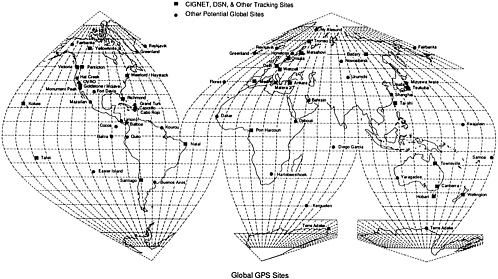
Figure 12 shows the permanent GPS stations currently in operation, including in particular the sites of the CIGNET and DSN networks. For precise geodetic applications it is essential to use dual-frequency receivers (1,200 and 1,600 MHz) to correct for ionospheric effects. Ionospheric and atmospheric effects parallel in every essential respect those previously discussed for VLBI, and the corrections follow very similar procedures. The network is growing explosively at the moment, and the recent IERS GIG'91 campaign involved more than 100 sites distributed globally. The proposed International GPS Geodynamics Service, to function under the aegis of IAG, has met with very positive response worldwide. Finally, the NASA-sponsored FLINN network will use GPS as its base technology.
GPS is the only space-geodetic technique available today that is fully commercialized. Its application to precise navigation, and the resulting large market, have brought substantial industry-led advances in miniaturization and decreases in equipment costs, to the point that equipment costs are expected to cease to dominate field budgets in the near future. Advanced applications to orbitography using onboard GPS receivers, discussed in Chapter 2, promise to dramatically alter the role of orbit errors as a dominant error source for many geophysical applications.
The main concern about GPS for commercial and precise scientific applications is the DoD's explicit policy of denying precise real-time positioning to general civilian users through implementation of Selective Availability (SA) (since March 1990) and its plans to test Antispoofing (AS) as soon as the system is declared fully operational (end of 1992). Provided that sufficient dwell time is allowed at each site —that is, long enough to average the dithering effects of SA—selective availability is not expected to impede significantly most geodetic applications, which involve site occupations of several hours. It is not yet known whether shorter deployments, typical of rapid static or even kinematic GPS surveys (see papers in GPS'90 Symposium Proceedings, Ottawa, Canada, 1990), will be affected enough to limit their geophysical usefulness. AS, which involves encryption of the code broadcast by the satellites, potentially could negatively affect a variety of precise civilian applications, in particular the mission support uses of GPS discussed earlier.
Doppler Orbitography and Radiopositioning Integrated by Satellite
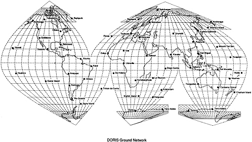
DORIS—Doppler Orbitography and Radiopositioning Integrated by Satellite —is a ground-based tracking system developed in France mainly for orbit determination, but it can be used for precise positioning as well. DORIS and the older TRANET (TRAnsit NETwork) systems use Doppler shifts of radio waves traveling between ground station and satellite to determine the line-of-sight velocity or range rate of the satellite. In TRANET the transmitter is on the satellite, and up to 40 globally distributed ground stations record the Doppler shifts. In DORIS the receiver is on the spacecraft, and the signals are transmitted by nearly 50 globally distributed radio beacons (Figure 13).
DORIS is a dual-frequency system (401 and 2036 MHz). The first DORIS receiver was launched successfully by the European carrier Ariane in January 1990 as a payload of the SPOT-2 satellite, and the ground network is fully operational. Willis et al. (1990) report encouraging initial results, with month-to-month repeatability of absolute positioning solutions between 0.23 and 0.40 m.
Precise Range and Range-rate Equipment
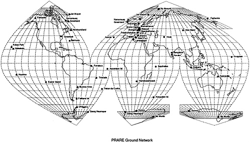
The German PRARE—Precise Range and Range-rate Equipment—is a space-borne, two-way, two-frequency (S/X band: 2,200 and 8,500 MHz) range and range-rate measuring system (Flechtner et al., 1990). PRARE is self-contained, with two-way transmission of all relevant data between the satellite and the ground stations on the tracking loop. The space segment has sufficient memory to store tracking data and corrective data transmitted from the global network stations for transmission to a master ground station during overflights. Through the master station, commands and broadcast data are transmitted into the onboard memory and disseminated from there to the ground stations.
The ground stations operate as regenerative coherent transponders, deployed as a global network (Figure 14). They are of low weight, are highly mobile, and can operate unattended. They comprise an antenna unit (0.6-m-diameter steerable parabolic dish), an electronics box, and a weather unit. S- and X-band signals modulated with a PRN (pseudorandom noise) code are sent to the Earth from the satellite, and the time delay in the reception of the two simultaneously emitted signals is measured on the ground and retransmitted to the onboard memory for later ionospheric correction of the data. In the ground station the received X-band signal is translated to 7.2 GHz, coherently modulated with the regenerated PRN
code, and retransmitted to the space segment, where the PRN code is fed into a correlator to determine, onboard, the two-way signal delay, which is a measure of the two-way slant range between satellite and ground station. In addition, the received carrier frequency is evaluated in a Doppler counter to derive the velocity of the spacecraft relative to the ground station. Four independent ground correlators and four Doppler counters allow simultaneous measurement with four ground stations in code multiplex.
The measurement accuracy of PRARE is estimated to be 0.1 mm/s for X-band Doppler (integration interval 30 sec) and 3 to 7 cm for X-band ranging (one measurement per second); the main error source is the atmospheric refraction (2 to 5 cm). The two-way unbiased range measurements provided by this system will make it less sensitive than other microwave systems to modeling errors resulting from atmospheric delay. The planned addition of two optical uplinks to the PRARE system may further reduce the atmospheric refraction limitation. With this upgraded equipment it will be possible to determine the atmospheric correction to better than 5 mm, so the resulting range accuracy will be better than 1 cm. The upgraded version, called PRAREE (i.e., PRARE Extended version), is planned for missions later in the decade.
Future Systems: GeoBeacon, Geoscience Laser Ranging Systems
Among future space-geodetic systems that might contribute significantly to a global network of fiducial sites are the GeoBeacon concept and the Geoscience Laser Ranging System (GLRS), mentioned earlier. Both systems could be deployed at global fiducial sites.
GeoBeacon is a proposed microwave system with multiple inexpensive ground transmitters, multiple inexpensive relay satellites, and one complex ground receiver station per region (e.g., Cangahuala, 1989). The ground stations would transmit signals in a number of narrow bandwidth channels (the exact sequence has not been fixed yet, but it could start as low as tens of megahertz and increase to several gigahertz). These signals would be received by all visible satellites and relayed to the ground station (after some onboard signal rejection to stop abuse of the system). A pseudorandom noise code would be incorporated into the signal structure to allow transmissions from different ground stations to be separated. In the ground station the signals would be correlated with replicas of the PRN codes, with tracking of higher frequencies being guided by the lower-frequency signals. This latter technique will allow low-power transmission in the higher frequencies. The observables from this system will be (doubly differenced) carrier-phase
measurements in each of the channels transmitted. Linear combinations of these carrier phases will allow the dispersive delay caused by the Earth's ionosphere to be estimated. Since the satellites will most likely be in low Earth orbit, and some of the transmitters will be at known positions, the data from these stations will be used to determine the satellite orbits. The accuracy of this system is expected to be similar to that of GPS. However, since the satellites probably will have no data storage facilities (and therefore data must be downlinked while both the transmitters and ground station are visible), the system may best be used to survey regional networks of small area (several hundred kilometers on a side).
GLRS is planned for launch on the EOS-B platform in 2001. The key features of GLRS are a dual-color laser ranging system and the ability to conduct both laser ranging to passive retroreflector targets and altimetry to natural surfaces. As currently planned, the laser transmitter consists of a Nd:YAG laser that will be pumped by a long-lived laser diode array. Its output frequency is doubled and tripled to produce pulses at 1064 (infrared), 532 (visible), and 355 (ultraviolet) nm. The visible and ultraviolet pulses are to be used for laser ranging, and the infrared pulse is to be transmitted at nadir for altimetry. The dual-color ranges will be used to correct in large measure the atmospheric propagation delay. The system is expected to provide (1 to 2 sec) normal points with subcentimeter accuracy. These range measurements combined with accurate GPS tracking of the EOS-B platform, are expected to yield station position estimates with a precision of a few millimeters within regional networks that are several hundred kilometers in extent. Data will need to be collected over 5 to 16 days from multiple EOS-B orbits to obtain accurate station position estimates. Since this system operates at optical wavelengths, it will provide a valuable complement to the microwave systems operating at the time.
Implementation Issues
A global geodetic network will have two independent parts: an organizational structure and a collection of stations. It is perhaps not immediately obvious that the organization will be fully as important as the stations in meeting the desired goals. During the next decade, local, regional, and national requirements will dictate the deployment of hundreds of continuously operated geodetic stations. This deployment will occur independently of any effort on the part of the community to produce an integrated global network. The effect is apparent from the proliferation of various networks such as CIGNET, PGGA, PRARE, and DORIS. These
stations, to be most useful, must be integrated into a single global network with consistent policies governing sites, receivers, and data. The organizational structure that provides this integration is the part of a global network that will require the most attention during the next few years. In the next two sections we discuss the organizational and physical implementation of an international global network of fiducial stations.
Organizational Implementation
The global nature of the geodetic network envisioned demands that an international entity be designated as the responsible governing body. This entity will need to derive its mandate from an international organization (e.g., the International Union of Geodesy and Geophysics, IUGG). To achieve an integrated network, channels of communication and responsibility must be simple and straightforward. This suggests a hierarchical structure with each observatory or data center taking direction from only one agency. In fact, however, the observatories and data centers will be parts of various national or subnational organizations. They will be established to meet goals other than those of the global fiducial network and will be funded from other sources. Funding agencies will allow these data centers and observatories to participate in the global network only when they clearly perceive a benefit to themselves. It will be a delicate task to negotiate a command and control structure that produces a consistent, reliable, and perhaps homogeneous network without infringing on the rights of the local, regional, or national organizations that support the observatories or data centers.
An example of such a structure can be found in the International Earth Rotation Service (IERS). The IERS was established in 1987 by the International Astronomical Union and IUGG. IERS is responsible for defining and maintaining conventional terrestrial and celestial reference systems, for determining Earth orientation and for organizing operational activities such as observation and data analysis, collecting and archiving appropriate data and results, and disseminating the results (see Appendix B). IERS consists of a Central Bureau and Coordination Centers for each of the principal observing techniques. The Central Bureau combines the various types of data collected by the service and disseminates to the user community the appropriate information on Earth orientation and the terrestrial and celestial reference systems. The Directing Board is composed of representatives of the International Astronomical Union, the International Association of Geodesy/International Union of Geodesy and Geophysics, the Federation of Astronomical and Geophysical Data Analysis Services, the Central
Bureau, and each of the Coordinating Centers. The Directing Board exercises general control over the activities of the service, including modifications of the organization and participation that would be appropriate to maintain efficiency and reliability, while taking full advantage of advances in technology and theory.
The organization of the global fiducial geodetic network may need to differ somewhat from IERS. The hardware required at each observatory is smaller and less expensive than the VLBI, SLR, and LLR stations that contribute to the IERS. Consequently, it is likely that many more smaller organizations will contribute to future global fiducial networks. For example, many states in the United States are establishing or have established regional GPS networks. It will probably be valuable to include some of these stations in a global network. However, this will mean including stations funded and operated by many different organizations with many different objectives and standards. The challenge facing us is to learn how to integrate these diverse stations into a single network that can meet the demands of all users, including those who may require great consistency and continuity across the network.
Physical Implementation
Users of global geodetic networks will fall into several categories, ranging from those who require raw data to those whose interest is in derived products, such as GPS satellite orbits or Earth orientation information. All users, however, depend directly or indirectly on three critical aspects of the network:
-
The coordinates of the stations must be known to the required accuracy in a consistent and fully documented reference frame.
-
The stations must be reliable, and specific care should be taken in implementing changes in the global network.
-
Data must be easily accessible to users and flow efficiently through the system.
Station Coordinates.
For many of the applications of global networks, users will need to know the coordinates of all the stations in a common global reference frame. Several such reference frames are in use in the world today. At present the only observations with sufficient precision and coverage to provide such a reference frame are the VLBI and SLR data sets. All of the current high-precision
reference frames used by GPS are defined by a set of station coordinates derived from VLBI and SLR observations, such as those of the IERS Terrestrial Reference Frame (Boucher and Altamimi, 1989, 1990). To obtain the coordinates of a GPS station in the adopted reference frame, it is necessary to determine its position relative to some station with known coordinates. Such a determination is only the first step, however. The determination must be carried all the way through to the appropriate reference point for the particular instrument at the station. For example, the appropriate reference points for GPS receivers are the phase centers of the antennae. At the levels of precision that are routinely attained today, knowledge of the coordinate vector at one epoch is not adequate. It is also necessary to know how this vector evolves as a function of time. The position of a station varies with time in response to many factors. A short list of factors influencing the location of station reference points would include:
-
solid Earth tides;
-
plate motion;
-
polar motion/UT1 series (essential for determining site motions);
-
regional deformation (e.g., fault slip, strain accumulation, volcanic inflation/deflation);
-
local site deformation (e.g., landslides);
-
meteorological effects (e.g., rainfall, desiccation, thermal cycling, freeze/thaw cycling);
-
monument instability;
-
relocation of antenna;
-
changes in antenna type; and
-
changes in surface loads and water table changes.
The actual time history imposed by some of these factors may be quite complex. At current levels of precision many can be approximated by either a linear change with time (plate motion, regional deformation, local site deformation); a quasi-periodic change with time (solid Earth tides, meteorological effects); or a series of step functions (changes in antenna position, changes in antenna type). To maintain knowledge of the position of the station reference point at all times, we must account for all of these factors. Solid Earth tides can be predicted with adequate precision. Plate motions—averaged over periods that are long compared to geodetic time series—can be estimated from other types of observations (e.g., geological) and should therefore be incorporated in the definition of the reference frame.
At some sites regional deformation may not contribute significantly to the station's position, while at other sites a regionally distributed network (10- to 30-km spacing) of ancillary sites may be required to understand the motion of the central site. A few regionally distributed sites (5- to 10-km spacing) will also be very useful in ascertaining the existence of local site deformation in those cases where this is a concern. Monument stability can be improved by careful attention to the techniques used in installing the monument and then monitoring its location with a few reference stations around the central station (10 to 100 m). In all these cases it is only necessary to occupy the ancillary station occasionally; continuous occupation will not generally be required. Apparent changes in position introduced by changes in antenna position or type cannot be eliminated unless they are determined by special calibration observations at the reference stations and recorded in a log of station history. There will be many reasons for changes in position; some are discussed below.
To maintain knowledge of the station's location it is critical that changes be carefully documented and made known to all users of the network. Meteorological effects on monument location are perhaps the least understood of all the effects on the list, but some of the techniques discussed for other effects will mitigate them. For example, reference stations occupied frequently enough may provide some insight into desiccation cracking or expansive soil swelling in wet conditions. Some meteorological effects can be identified by their periodicity; temperature variations can produce diurnal and annual signals. One of the complicating factors with meteorological influences on the actual station position is that meteorology can also affect the data obtained and thus produce apparent changes in station location (e.g., Wyatt, 1982, 1989). It may not be easy to separate these two effects.
With a possible fiducial sites spacing on the order of 103 km, the question of establishing the coordinates of sites that are not collocated with VLBI or SLR becomes important in implementation. It is clearly infeasible, financially and operationally, to operate mobile VLBI or SLR equipment at all sites. As a consequence, determining the GPS orbits to support part-per-billion accuracy will be essential to the implementation. Only with such accuracy will it be possible to obtain meaningful ties to the global reference frame for fiducial sites that have not been occupied by VLBI or SLR. The essential aspect of such orbit precision is the ability to support three-dimensional geodesy at the level of 1 ppb.
Station Reliability.
Users of the network must be able to make observations at any time with certain knowledge that the required network products will be available. Our goal should be network integrity 100% of the time. At critical stations this may require onsite service personnel, adequate spare hardware, and ongoing evaluation of data quality so as to recognize problems immediately. This does not necessarily imply that every station in the network will have to be operational 100% of the time. For some purposes it may be adequate to have sufficient redundancy in the network so that the loss of some stations some of the time can be tolerated. It may be enough to have 90% of the stations operational 90% of the time. However, many kinds of applications will be much better off with 100% reliability or as close to that as we can achieve. A local scientist depending on the data from a network station at Mojave as part of some southern California observations will not be satisfied if the network operators report that, while Mojave was not operating during the campaign, Ft. Davis, Texas, was operating, and from a network perspective they are equivalent stations. For example, to someone looking for subtle changes in a vector as a function of time, a change in the set of stations used to produce an ephemeris may be one more potential noise source. If isolated from the details of the network operation, the user may have no (easily determined) knowledge of what network stations contributed to the ephemeris disseminated by the agency operating the global network.
One of our principal tools for improving reliability and performance is to upgrade or replace both hardware and software components of the system with newer and better ones. The evolution of technology makes changes in sites, instrumentation, and monumentation inevitable over the lifetime of a global geodetic network. Such change is desirable, but it does have a significant disadvantage. Changes in the networks greatly complicate the solution of problems in that artificially induced changes must be separated from changes in the phenomena under study.
Global networks have been and will be implemented to contribute to the solutions of specific scientific problems (and through them to the solutions of societal problems). Solving these problems will often require signal-to-noise ratios that are very near the limits of the technology. For example, relative plate motion rates are typically a few millimeters per year for most plates and range up to about 100 mm/yr for the fastest-moving plates. The size of the major tectonic plates requires that their relative motion be observed over vectors thousands of kilometers long. The resolution of a relative plate motion rate of 50 mm/yr (e.g., Pacific-North America) in a few years over 5,000-km vectors requires an accuracy of 50 mm/5,000 km = 0.01 ppm. Even more challenging is the problem of resolving changes in plate rates or distinguishing between various models that may
predict slight differences in plate rates. Other scientific problems to be addressed with global networks are similar; they all require the highest precision obtainable from global networks.
Not only do the problems to be tackled require the highest accuracy possible from each measurement, but they also require that measurements be continuous. Producing adequate signal-to-noise ratios for many problems will require making measurements over periods of years. In the past, decades have often been required to obtain useful signal-to-noise ratios. To apply data collected over extended periods to geophysical problems, it will be necessary to maintain high accuracy over these same periods. Otherwise we will be unable to distinguish apparent changes from changes in the geophysical phenomena under study, be it plate motion, global sea level, ice sheet mass balance, or others. The quest for accuracy forces us to look continually for new and better ways to make our measurements. The instrumentation deployed to make the observations, the techniques used in making the measurements, and the models used in deriving Earth science from the data are subject to continual evolution, and occasionally revolution, in attempts to improve precision. The challenge facing us is to implement changes in such a way that we do not lose continuity. At the same time that we are upgrading our networks to take advantage of the most recent improvements, we must maintain a careful tie to the older observations so that we do not destroy valuable time series. Occasionally, it may be impossible to reconcile these two conflicting goals; often it will be difficult and perhaps expensive.
The first and most important step in accommodating change is maintaining a complete and accurate record of the changes that take place, particularly those changes over which control can be exercised, such as changes in equipment, position, and antenna. This record should document all changes that potentially could affect the accuracy or continuity of the parameters of interest. A second important step is to maintain continuity in the position of the stations that make up the global network. It is essential that the relative position of an existing station and its replacement station be known to 1 mm in all three coordinates. This positional continuity must be maintained through changes in antenna type or antenna location. Whenever a change is required, the positional continuity must be verified through extended experiments. New instruments should be run in parallel with the old ones for extended periods. The overlap time should be long enough to allow an overlapping data set to be collected and analyzed. Problems usually are not discovered until someone sits down and carefully looks at the data. In light of the long delay between data collection and data processing, an extended overlap period will often be required. When new models are used to interpret data,
an attempt should be made to understand the impact of the differences in the models. Where possible it is recommended that the continuity of time series derivatives be protected as well as the continuity of the time series themselves. Protecting the continuity of even the first derivative will require considerable commitment of resources, but the Panel believes that this commitment is essential at critical sites. The Panel discussed how best to accommodate technological progress without losing continuity in the geodetic time series. For implementing change in global geodetic networks, especially the core network, the following recommendations are made:
-
Continue VLBI observations at key sites for the foreseeable future to provide the long vector precision required by many applications and to provide a reference system for comparison of newer techniques.
-
Continue SLR observations at key sites for the foreseeable future to provide a tie to the center of mass of the Earth and to provide an independent system with which to compare VLBI.
-
Investigate the role of GPS in complementing the roles currently filled by VLBI and SLR—for example, reference coordinate system, Earth orientation, and plate motion monitoring over all length scales.
-
Continue to evaluate new techniques, such as GeoBeacon and GLRS, for potential contributions to solutions of problems using global networks.
-
When major changes in instrument systems are made at critical sites (e.g., the conversion of monitoring at Vandenberg Air Force Base from VLBI to GPS), obtain and analyze several years of parallel data before removing the old systems altogether.
-
Where there are significant discrepancies in existing systems (e.g., Ft. Davis, Texas), assign high priority to continuing observations with no change in technique, no gap in data, and no discontinuity in the time series or its first derivative.
-
Maintain mobile VLBI/SLR capability to allow reoccupation of VLBI/SLR sites and evaluation of the long-term behavior determined under item 5 above when new techniques indicate differences between new and old observations.
Data Flow, Processing, and Archive Issues.
The tracking stations of the global fiducial network will generate a substantial volume of data that must be easily moved from the tracking sites to the analysis centers and to other users. Experience in geodesy and with other types of global geophysical data (e.g., seismic) suggests that these data should be managed though a number of Data
Centers, organized and designed according to the kind of tracking data they manage, the volume of data that passes through them, and various geographical considerations.
Some of the factors influencing data management include:
-
The network concept described herein includes a core network of 30 or more GPS stations. These are treated as primary stations, which should be operated continuously, and collocated, insofar as possible, with VLBI or SLR observatories or sites regularly visited by transportable or mobile VLBI or SLR systems. They define the GPS reference frame consistent with the other space-based geodetic techniques. Data collected by the GPS core stations are used for generating precise ephemerides and for solving for Earth orientation and rotation parameters.
-
The network should be organized into regional clusters of stations that can be used (1) to monitor regional or local crustal deformation or relative plate motions and (2) to supplement the core network, providing redundancy and therefore enhanced orbit control by serving as additional fiducial stations. Although such stations may be occupied intermittently at first, many will eventually move to continuous operation, as the technology for data acquisition improves and as efficient data transfer and data processing algorithms are developed.
-
The data centers will most likely have direct links to tracking receivers. This requires detailed local knowledge of receiver types and data transmission options. Although all data ideally should be available to all users, in practice certain sites will have restricted data access, for a variety of reasons, depending on the operator and possibly involving security issues. It is important that the data centers establish working protocols with the appropriate agencies to obtain access to data on a case-by-case basis.
Estimates of raw data volumes depend on operating characteristics of the stations, sampling frequency, and so on. Data compression schemes can be devised to reduce the burden of data transmission and storage. A rule of thumb is that tracking stations may generate about 1 Mbyte per day of raw data. Therefore, a fully deployed fiducial network may generate several hundred Mbytes daily. Consequently, large-capacity mass storage systems (e.g., optical) will be required to make all data conveniently accessible. Specific details and requirements for archival storage remain to be completely established. It must be kept in mind, however, that such a volume of data is characteristic of current global seismic
networks, so that many technological solutions adopted to deal with the data flow generated by such networks could be adapted for geodetic data. (A substantial difference exists, however, as the bulk of seismic data is processed through a relatively simple detection processor, and more complex processing is restricted to seismic event recordings, whereas essentially all geodetic data must be fully processed.)
The potential data products that an appropriately organized service could provide using data from the global fiducial network include the following:
-
GPS Ephemerides: A wide range of ephemeris accuracies are required by the user community. Some applications can be satisfied with an ephemeris accurate to 10 m, while others require centimeter accuracy. Further, the time delay in the ephemeris availability varies from perhaps a few days to several weeks. The potential user community includes, for example, regional survey institutions with accuracy requirements of one part in 106, while crustal motion applications have requirements of a few parts in 109. In all cases it is expected that the community requires ephemerides that are essentially free of Selective Availability or other degrading effects. Some applications may benefit from predicted ephemerides, provided they exceed the quality of the broadcast information. Both regional and global ephemerides will need to be produced, with the former being available within a few days and the latter within a few weeks or less. In addition, global ephemerides based on the GPS core network could be computed within a few days with the goal of providing Earth orientation data to the IERS. Accuracy estimates should be provided together with the orbits as a matter of policy.
-
Clock Information: Since field operations with GPS typically rely on internal receiver clocks/oscillators, information about the satellite clock performance is important to establish the correct receiver time. For the highest-accuracy applications, satellite and fiducial clock information of sufficient quality for the support of the desired accuracy will be required.
-
Atmospheric and Ancillary Data: With an appropriately distributed network of stations, the dual-frequency data collected can be used to infer ionosphere parameters and possibly aid in the improvement of ionospheric models. In addition, properly instrumented stations could record meteorological data for use in estimating the atmospheric-delay correction to GPS data. One possible product could be the development of atmosphere models that could be readily applied to data from sites in the vicinity of the respective fiducial stations, although the scale length of water vapor variation may be too short for such applications in most areas.
-
Satellite and Station Status: Information about the satellite and station status, including anomaly determination made as a result of data analysis, would assist field and postprocessing operations. These status reports should reflect a different level of status assessment than that available from the satellite control center and from individual stations. Additional information that could be useful includes the historical set of satellite force parameters, such as the y-bias and radiation pressure scale factors, as well as orbit change parameters (delta-V).
-
Verification and Data Quality Assessment: The statistics associated with the estimates of satellite states and other parameters, coupled with regular monitoring, are vital in assessing the overall quality of the estimates and the quality of the tracking data provided by the fiducial sites. Comparison of overlapping fits could be used as a preliminary indication of ephemeris quality. The globally derived ephemerides will be distributed to the regional analysis centers for further evaluation. A source of concern in this respect is that the time scale over which problems continue to be discovered in any given data set is occasionally quite long (years), so that even the best solutions may have to be updated long after they were first obtained. This raises the fundamental issue of updating all user data bases and keeping them synchronized.
-
Earth Rotation/Reference Frame: It is expected that GPS will become a regular contributor to the IERS, although a complete demonstration is still lacking. Since baselines determined from GPS observations are affected by error sources that are somewhat different from those affecting other techniques, it offers an opportunity to separate technique-dependent systematic effects from geophysical phenomena. In addition, GPS will continue to provide geodetic ties between nearly collocated different systems, as well as the temporal variations in these ties. The potential for GPS to establish its own reference frame exists, but the technical requirements or limitations, if any, remain to be determined. At least for the Earth rotation applications, high-accuracy ephemerides are expected implicitly to be generated concomitantly with the Earth rotation parameters. For other applications, however, Earth rotation parameters obtained from IERS may be used in calculating GPS ephemerides.
-
Edited Tracking Data: The edited tracking data from the fiducial sites used in the ephemeris estimation process can be made available along with appropriate quality indicators. However, as indicated above, a mechanism for dealing with data problems discovered later must be devised and implemented.
-
determinations of site coordinates, including their time variation, for the sites in
-
the global network. This could provide a check on the quality of regional surveys and on the accuracy of data products.
It should be noted that all these data products are at least partially available at present. The specific needs of the user community are not completely clear, however, and will have to be developed concomitantly with the progressive installation of the network. As has been the case with the MERIT project, much can be learned from focused campaigns of global scope. By and large, the data flow requirements for the data products mentioned are less demanding than those attached to the flow of the raw data. The establishment of archive centers with catalogs describing available data and their location is an essential element of the global network. Use of electronic networks should permit a user to browse the holdings of an archive, as well as determine the data holdings for raw and higher-level data products stored at any other archive worldwide.
At the same time, most of the subtle problems cannot be detected until a fairly high-level (sometimes even very advanced) analysis is performed. Consequently, in parallel with data centers, it is imperative that a number of analysis centers be established and adequately funded, with a clear mission to keep up with the data flow and provide reliable feedback to network operations. As with most other disciplines, this is the only mechanism that will maintain the level of quality control required by the scientific objectives discussed in the previous chapter.


