
1
Introduction
R. L. Schuster, U.S. Geological Survey, Denver, Colorado
On March 5, 1987, two earthquakes (Ms=6.1 at 2054 local time and Ms=6.9 at 2310 local time) occurred along the eastern slopes of the Andes Mountains in northeastern Ecuador. The epicenters were located in Napo Province (Figure 1.1), approximately 100 km ENE of Quito and 25 km N of Reventador Volcano (Figure 1.2, Figure 1.3). Modified Mercalli Intensity (MMI) values as high as IX have been estimated for the epicentral area (Espinosa et al., this report). The shaking damaged structures in towns and villages near the epicentral area, particularly in the town of Ibarra (50 km NW of the epicenters), where two brick churches were severely damaged; several other brick buildings in Ibarra had to be reinforced subsequent to the quakes because of structural damage. In addition, considerable damage occurred to reinforced concrete buildings and foundations of wooden buildings in the village of Baeza (60 km SSW of the epicenters). In El Chaco village (50 km S of the epicenters), a steel-frame gymnasium, which was under construction, collapsed (Hakuno et al., 1988).
In spite of the seriousness of this structural damage, the economic and social losses directly due to earthquake shaking were small compared with the effects of catastrophic earthquake-triggered mass wasting and flooding in the area adjacent to Reventador Volcano (Figure 1.2). Rock and earth slides, debris avalanches, and debris and mud flows E of the Andes resulted in the destruction or local severing of nearly 70 km of the Trans-Ecuadorian oil pipeline and the only highway from Quito to Ecuador's eastern rain forests and oil fields. The total volume of earthquake-induced mass wasting has been estimated at from more than 75 million m3 (Crespo et al., 1987) to about 110 million m3 (Hakuno et al., 1988; Okusa et al., 1989). Economic losses have been estimated at $1 billion; the effects of widespread denudation on the agricultural and hydroelectric development of the
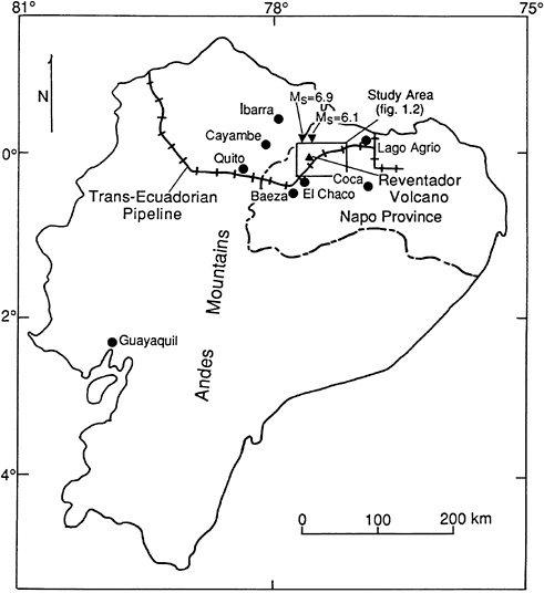
FIGURE 1.1 Index map of Ecuador showing locations of Napo Province, the Andes Mountains, Reventador Volcano (upright triangle), epicenters of the 1987 earthquakes (inverted triangles), the Trans-Ecuadorian oil pipeline, towns and villages (solid circles) that suffered structural damage from the earthquakes, and the mass-wasting study area (open rectangle; Figure 1.2).
region are difficult to evaluate, but undoubtedly were very large (Nieto and Schuster, 1988). Nearly all of the estimated 1,000 deaths from the earthquakes were a consequence of mass wasting and flooding. Because the mass wasting and flooding produced a high percentage of the economic and human losses resulting from these earthquakes, this report deals primarily with these processes, their socioeconomic effects, and the resulting social
implications. Observations related to these factors were made on site in Ecuador by the National Academy of Sciences/National Research Council (NAS/NRC) research team during the spring and summer of 1987.
Earthquakes are a major cause of mass wasting in many parts of the world. Earthquake-induced landslides have been documented for thousands of years; the earliest on record are landslides that dammed the Lo and Yi rivers in Hunan Province, China, in 1767 B.C. (Xue-Cai and An-ning, 1986). During the twentieth century, earthquake-induced landslides have caused tens of thousands of deaths and billions of dollars in economic losses (Keefer, 1984). In some cases, they have denuded thousands of square kilometers of unstable hillslopes. Particularly striking has been the denudation of jungle-covered, saturated slopes in tropical areas (Pain, 1972; Garwood et al., 1979).
A secondary hazard caused by earthquake-induced landslides is the formation of landslide dams. These natural stream blockages cause upstream flooding by stream impoundment, and they often breach catastrophically, causing major downstream flooding. Some of the world's most devastating floods have resulted from failure of large landslide dams that were formed by earthquake-induced landslides (Schuster and Costa, 1986; Costa and Schuster, 1988). In a review of more than 400 cases of historic landslide damming, Costa and Schuster (1991) have noted that about 35 percent of these blockages have been formed by landslides triggered by earthquakes.
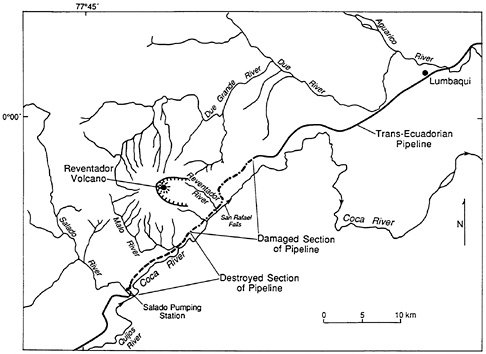
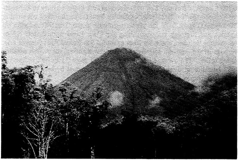
The area of eastern Ecuador hardest hit by mass wasting due to the March 5, 1987, earthquakes was S of the epicentral area in the vicinity of Reventador Volcano (Figure 1.2). Most casualties from the earthquakes occurred in this region ( Figure 1.4); the greatest damage to the Trans-Ecuadorian oil pipeline and highway occurred along the Coca River immediately SE of Reventador Volcano, upstream from beautiful San Rafael Falls (Figure 1.5). Because of the volcanic activity and river downcutting, the region exhibits strong relief. The average valley slopes range from 35 to 45°; before the 1987 landsliding, these slopes were generally covered by residual soils of variable thickness and by a dense, subtropical jungle.
The earthquake-induced slope failures were very fluid. About 600 mm of rain fell in the region in the month preceding the earthquakes; thus, the surface soils had a high moisture content. The slope failures commonly started as thin slips, which rapidly turned into very fluid debris avalanches and debris flows. The surficial materials and the thick jungle vegetation covering them flowed down the slopes into minor tributaries and then were carried into the major rivers (Salado, Quijos, Malo, Coca, Dué, Dué Grande, and Aguarico: Figure 1.2). Millions of tons of silty, gravelly sand, as well as tree remains and other organic matter, were deposited in the rivers (Figure 1.6). Many of the slopes were almost entirely denuded of their soil and jungle covers (Figure 1.7).
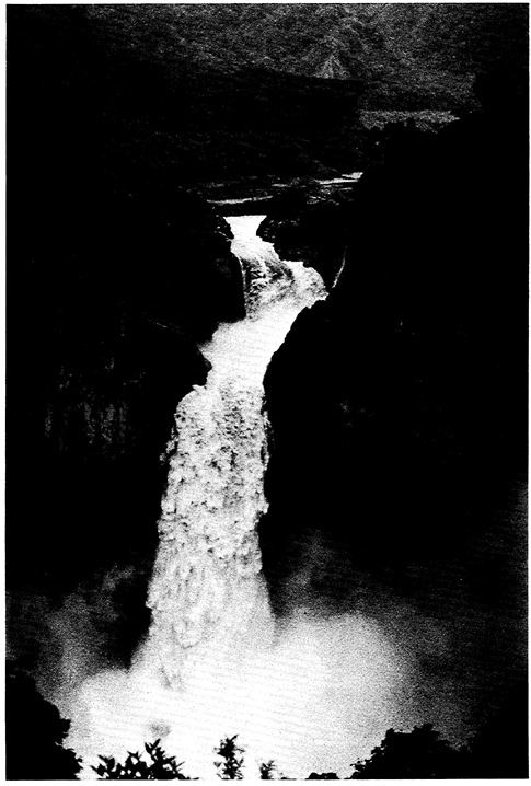
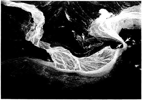
FIGURE 1.6 Aerial view of the confluence of the Quijos River (lower left) and the Salado River (upper left) to form the Coca River (flowing to the right). Postearthquake braided debris-flow and flood deposits are as much as 15 m thick in the valley bottoms. Bedrock constriction of the Coca River (indicated by two arrows near right edge of photo) probably caused short-lived damming of the river, which contibuted to upstream flooding and rapid sedimentation. Note landslide (single arrow near center of photo) that badly damaged the Salado pumping station on the Trans-Ecuadorian oil pipeline.
Widespread stripping of saturated surficial materials and jungle cover from steep slopes by earthquake shaking similar to that which occurred in the Reventador area in 1987 has been noted in other humid tropical areas in a few similar catastrophes in this century. In September 1935, two shallow earthquakes (M=7.9 and M=7.0) in the Torricelli Range on the N coast of Papua New Guinea caused “hillsides to slide away, carrying with them millions of tons of earth and timber, revealing bare rocky ridges completely devoid of vegetation” (Marshall, 1937). Approximately 130 km2 (8 percent of the region affected) was denuded by the landslides (Simonett, 1967; Garwood et al., 1979). Materials from the slides flooded the valleys, and, in some cases, blocked major rivers (Stanley, 1935). In November 1970, an M=7.9 earthquake, which was located along the N central coast of Papua New Guinea, triggered landslides that removed shallow soils and tropical forest vegetation from steep slopes in the Adelbert Range (Pain and Bowler, 1973). About 25 percent of the slope areas in the 240-km2 area that was
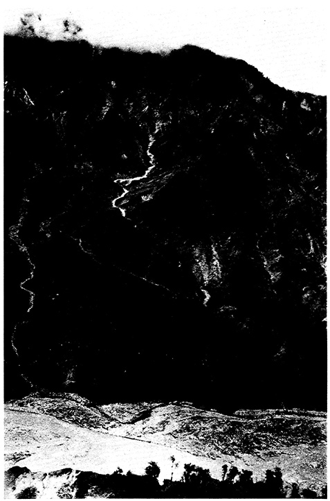
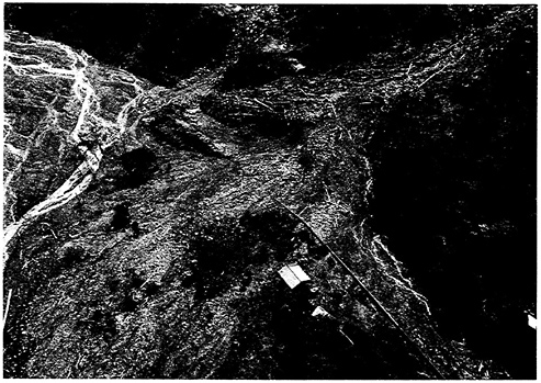
FIGURE 1.8 Aerial view of destruction of the Trans-Ecuadorian oil pipeline and adjacent highway by a debris flow issuing from a minor tributary of the Coca River. Location is near mouth of the Reventador River.
affected by landsliding were denuded (Pain, 1972). The soil debris and its cover of vegetation flowed off the slopes into drainage channels. Similarly, in 1976, two shallow earthquakes (M=6.7 and M=7.0) struck the sparsely populated SE coast of Panama, causing huge areas of landsliding. Garwood et al. (1979) calculated that the slides denuded approximately 54 km2 (12 percent of the affected region of 450 km2). Although the M=9.2 earthquake that struck southern Chile in May 1960 occurred in an area of temperate forest rather than in tropical jungle, it caused slope failures in the Valdivian Andes similar to those in Papua New Guinea and Panama. Veblen and Ashton (1978) estimated that more than 250 km2 of forest slopes were denuded by mass wasting in the 1960 event.
Given the size of the mass-wasting catastrophe in the Reventador area, damage caused by direct impact of deep-seated slides or slumps was secondary to that caused by thin slips, avalanches, flows, and floods. Although individual slides did some damage to the Trans-Ecuadorian pipeline (Figure1.8), roads, and structures, the greatest destruction of property was caused by flood surges in the main rivers (Figure 1.9). Because of antecedent precipitation, the rivers were near flood stage before the earthquakes occurred, so that the large volumes of landslide debris that flowed into the
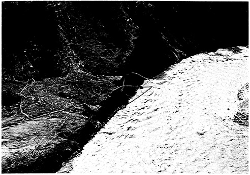
FIGURE 1.9 Destruction of Trans-Ecuadorian oil pipeline and highway by flood eroqqsion on the left bank of the Coca River as a result of the March 5, 1987, earthquakes.
valleys further raised the river stages (Nieto and Schuster, 1988). It is likely that the highest flood surges were caused by breaching of short-lived dams on tributaries carrying large sediment loads, by large debris flows moving directly off valley walls, or by debris blockages at narrow constrictions of the river channels (Figure 1.10).
In summary, interrelated multiple hazards produced the catastrophic events of March 5, 1987, in the Reventador area. The tragic occurrence of two large earthquakes within 3 hr in an area of heavy antecedent rainfall, and steep slopes covered by unstable volcanic and residual soils with high water contents, resulted in massive slope failures of high fluidity. The large volumes of these slope failures and the breaching of the resulting ephemeral debris dams caused the flood surges that were responsible for most of the damage.
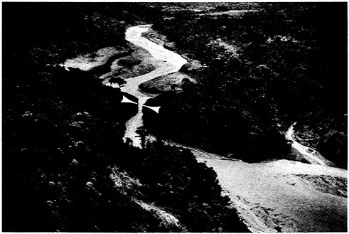
FIGURE 1.10 Upstream view of Salado River, showing location of bedrock constriction (white arrows) that caused short-lived damming of the river. Note trimline in jungle cover along lower valley wall upstream of the river constriction. This trimline indicates position of the shoreline that was formed by damming of the river to a level 10-15 m above current river level.
REFERENCES
Costa, J. E. , and R. L. Schuster . 1988 . The formation and failure of natural dams. Geological Society of America Bulletin , 100 : 1054–1068 .
Costa, J. E. , and R. L. Schuster . 1991 . Documented Historical Landslide Dams from Around the World . U.S. Geological Survey Open-File Report 91–239 : 486 .
Crespo, E. , K. J. Nyman , and T. D. O'Rourke . 1987 . Ecuador Earthquakes of March 5, 1987 . Earthquake Engineering Research Institute Special Earthquake Report, 4 .
Garwood, N. C. , D. P. Janos , and N. Brokaw . 1979 . Earthquake-caused landslides: A major disturbance to tropical forests . Science 205(4410, 7 September) : 997–999 .
Hakuno, M. , S. Okusa , and M. Michiue . 1988 . Study Report of Damage Done by the 1987 Earthquakes in Ecuador. Research Report on Unexpected Disasters, Research Field Group, Natural Disasters and the Ability of the Community to Resist Them, Supported by the Japanese Ministry of Education, Culture, and Science (Grant No. 626010221), 38 .
Keefer, D. K. 1984 . Landslides caused by earthquakes . Geological Society of America Bulletin 95 : 406–421 .
Marshall, A. J. 1937 . Northern New Guinea, 1936 . Geographical Journal 89(6) : 489–506 .
Nieto, A. S. , and R. L. Schuster . 1988 . Mass wasting and flooding induced by the 5 March 1987 Ecuador earthquakes . Landslide News, newsletter of The Japan Landslide Society , 2 : 1–3 .
Okusa, S. , M. Hakuno , and M. Michiue . 1989 . Distribution of factors of safety for natural slope stability—an example of Ecuador . Proceedings of the Japan-China Symposium on Landslides and Debris Flows. Niigata, October 3, Tokyo, October 5, The Japan Landslide Society and The Japan Society of Erosion Control Engineering:273 –278 .
Pain, C. F. 1972 . Characteristics and geomorphic effects of earthquake-initiated landslides in the Adelbert Range, Papua New Guinea . Engineering Geology 6(4) : 261–274 .
Pain, C. F. , and J. M. Bowler . 1973 . Denudation following the November 1970 earthquake at Madang, Papua New Guinea . Zeitschrift für Geomorphologie Suppl. Bd. 18 : 92–104 .
Schuster, R. L. , and J. E. Costa . 1986 . A perspective on landslide dams . Pp. 1–20 in Landslide Dams: Processes, Risk, and Mitigation , R. L. Schuster , ed. Geotechnical Special Publication No. 3 , American Society of Civil Engineers .
Simonett, D. S. 1967 . Landslide distribution and earthquakes in the Bewani and Torricelli Mountains, New Guinea . Pp. 64–84 in Landform Studies from Australia and New Guinea , J. N. Jennings and J. A. Mabbutt , eds. Canberra : Australian National University Press .
Stanley, G. A. V. 1935 . Preliminary notes on the recent earthquake in New Guinea . Australian Geographer 2(8) : 8–15 .
Veblen, T. T. , and D. H. Ashton . 1978 . Catastrophic influences on the vegetation of the Valdivian Andes, Chile . Vegetation 36(3) : 149–167 .
Xue-Cai, F. , and G. An-ning . 1986 . The principal characteristics of earthquake landslides in China . Geología Applicata e Idrogeología 21(2) : 27–45 .


