
6
Effects on Lifelines
E. Crespo, * Cornell University, Ithaca, New York
T. D. O'Rourke, * Cornell University, Ithaca, New York
K. J. Nyman, * Cornell University, Ithaca, New York
GENERAL OBSERVATIONS
From March 19 to April 3, 1987, reconnaissance personnel were sent from Cornell University to Ecuador to evaluate the effects on lifelines of the March 5, 1987, earthquakes. An additional visit was made on August 17-27 to collect data concerning the effects of landslides and flooding on key lifeline facilities and to observe reconstruction efforts in areas most severely influenced by the earthquakes. Although the primary focus of the reconnaissance missions was the Trans-Ecuadorian pipeline, considerable effort was spent on gathering information about other lifelines. Visits were made to the City of Quito and towns in the provinces of Pichincha, Imbabura, and Napo (Figure 4.1). Interviews were conducted with government and municipal workers as well as with local people.
Damage to lifelines was severe in areas near the earthquake epicenters. Specifically, there was major damage to the Trans-Ecuadorian (crude oil) and Poliducto (propane) pipelines, as well as to the principal highway linking Quito and Lago Agrio (Figure 6.1), the main town of the oil-producing region of Ecuador. Damage to lifelines in other areas was relatively light and is summarized briefly under the following subheadings.
Water Distribution Systems
Officials of EMAP, the municipal agency responsible for the water supply to Quito, were interviewed. They reported that no damage was sustained to the pipeline network, pump facilities, and reservoirs servicing
|
* School of Civil and Environmental Engineering |
Quito. The only damage to underground water mains that was observed was in the town of Baeza (Figure 6.1), which is approximately 60 km from the epicenters. This observation was made at one location, where a 150-mm-diameter PVC pipeline was being repaired. The full extent of pipeline damage in Baeza could not be determined; however, there was considerable damage to one-and two-story structures, primarily of reinforced masonry construction.
Electric Power Systems
Officials with EEQ, the municipal electricity authority for Quito, were contacted. They reported that electricity had been interrupted to all neighborhoods of Quito for more than 2 hr after the second earthquake (M=6.9). This interruption was attributed to the functioning of emergency breaker switches. Inspection of electrical equipment after the earthquakes indicated that some maintenance and minor repair were needed.
No damage to hydroelectric facilities was reported by INECEL, the national electricity institute. A small, privately owned hydroelectric plant in the town of Papallacta (Figure 6.1, Table 6.1), approximately 50 km from the epicenters, was visited. No damage was observed in the power plant or its piping facilities.
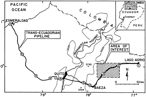
FIGURE 6.1 Route and station locations of the Trans-Ecuadorian pipeline.
TABLE 6.1 List of Pump and Pressure-Reduction Stations on the Trans-Ecuadorian Pipeline
|
Number |
Name |
Elevation (m) |
|
1 |
Lago Agrio Pump Station |
296 |
|
2 |
Lumbaquí Pump Station |
842 |
|
3 |
Salado Pump Station |
1,268 |
|
4 |
Baeza Pump Station |
2,001 |
|
5 |
Papallacta Pump Station |
3,007 |
|
6 |
San Juan Pressure-Reducing Station |
3,496 |
|
7 |
Chiriboga Pressure-Reducing Station |
1,997 |
|
8 |
La Palma Pressure-Reducing Station |
1,612 |
|
9 |
Santo Domingo Pressure-Reducing Station |
566 |
|
10 |
Quininde Pump Station |
96 |
|
11 |
Balao Marine Terminal |
0 |
Pan-American Highway
The Pan-American Highway is the major transportation facility connecting the towns and cities of the Andean region. Landslides in volcaniclastic deposits were caused by the earthquakes and interrupted traffic between the cities of Quito and Cayambe (Figure 1.1). The majority of these landslides originated in the faces of steep roadcuts and involved relatively shallow raveling and toppling of cemented sands, ash, and weak rock.
Transportation between Quito and the town of El Quinche (20 km ENE of Quito) was interrupted by a relatively large landslide 1 week after the earthquakes. This landslide occurred in volcaniclastic deposits at a steep roadcut. Approximately 24 hr was required to clear the road at this location.
Natural Gas Supply
Natural gas in Ecuador is used primarily for cooking and is supplied in pressurized canisters and tanks of propane. There are no natural-gas-pipeline distribution networks in Ecuador. There are several transmission pipelines, which are used to convey propane, and one of these, known as the Poliducto pipeline, was damaged by the earthquakes. A more detailed description of this line and associated damage is given under the next two major headings.
Although earthquake damage to lifelines was light throughout most of the country, damage near the epicenters was so severe and widespread that it had a major economic impact on the country, with repercussions felt worldwide. Approximately 40 km of the Trans-Ecuadorian pipeline had to be
reconstructed, making this the single largest pipeline failure in history. Because of the scale and importance of the damage, this chapter concentrates on the characteristics and postearthquake observations related to the Trans-Ecuadorian pipeline, with supplemental descriptions of the Poliducto natural gas pipeline and adjacent highway.
CHARACTERISTICS OF THE TRANS-ECUADORIAN AND POLIDUCTO PIPELINES
The Trans-Ecuadorian pipeline (crude oil) is composed primarily of 660-mm-diameter line pipe and associated pump and pressure-reducing stations. The pipeline was commissioned in 1972. It is composed of X-60 grade steel with wall thickness ranging from 9.5 to 20.6 mm. The pipeline is the main crude oil transportation facility in the country, conveying virtually all oil from the eastern oil fields to a marine terminal port near Esmeraldas on the Pacific Ocean ( Figure 6.1). The pipeline operates at a maximum internal pressure of 9.7 MPa and moves from 250,000 to 300,000 barrels of oil a day.
The Poliducto pipeline is composed of 150-mm-diameter line pipe and associated compressor station pressure-regulation equipment. Its wall thickness is 7.1 mm. The line was built after the Trans-Ecuadorian pipeline was commissioned, and closely follows the right of way for the crude oil line. The Poliducto pipeline is a multiproduct facility. It conveys different types of hydrocarbons at different times, including propane gas. The line extends from Lago Agrio in the eastern oil field to Quito.
Figure 6.1 shows a plan view of the Trans-Ecuadorian pipeline, with pump stations at locations 1 through 5 and 10, and pressure-reducing stations at locations 6 through 9. The endpoint of the pipeline at the Balao marine terminal is situated near Esmeraldas at location 11. The pipeline conveys oil from an initial elevation of 296 m at the Lago Agrio pump station to a maximum elevation of 4,060 m at a mountain pass E of Quito to the Balao marine terminal at sea level. The elevations relative to sea level of the various pump and pressure-reducing stations are summarized in Table 6.1. For purposes of clarity, the Poliducto pipeline is not shown, although it should be recognized that this facility follows the same right-of-way corridor from Lago Agrio to Quito as illustrated in the figure.
The total length of the Trans-Ecuadorian pipeline is 498 km from Lago Agrio to Esmeraldas. Approximately 200 km, from Lago Agrio to a location roughly halfway between Quito and the Papallacta pump station, is constructed primarily above ground. Along this part of the route, the line pipe is supported every 12 m on either an “H” pile support frame or concrete-pedestal foundation saddle. The support frame consists of two 150-mm-diameter pipe piles driven 6 m into the ground, connected by a pipe cross beam welded to the driven piles. The pipeline rests on the cross
beam, which is fitted with a curved center plate saddle. A concrete pedestal consists of a 1-m-square foundation footing with a cradle keyed vertically into the footing. The 50-mm-tall vertical concrete section is fabricated to a semicircular shape at the top, which acts as a saddle to support the pipe. The above ground supports do not have special features to restrict pipe movement either laterally or longitudinally. On steep terrains, however, longitudinal anchors are used periodically to prevent slippage of the pipe downhill through the supports.
The remaining 298 km of the pipeline from E of Quito to Esmeraldas is buried. One section of the line, from location 8 to 9 as depicted in Figure 6.1, is composed of 510-mm-diameter pipe. All other sections are composed of 660-mm-diameter pipe.
The area of most severe disruption is shown by means of the hachured zone in Figure 6.1. It was in this general region that landslides and floods triggered by the earthquake damaged the line pipe and the Salado pump station (location 3).
PIPELINE DAMAGE
Figure 6.2 shows an expanded view of the hachured zone identified in Figure 6.1. This general region includes the pipeline route from its crossing
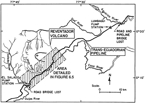
FIGURE 6.2 Area of major pipeline damage.
of the Aguarico River to its crossing of the Salado River. The pipeline alignment follows a SW course along the Coca River basin. Between the Aguarico and Salado Rivers, the pipeline attains a maximum elevation of 1,700 m, after which it descends approximately 500 m to the Coca River floodplain and then follows the N bank of the river to the Salado pump station.
The Coca River is deeply entrenched and borders the southeastern foothills of the active volcano, Reventador. Reventador Volcano is a large stratovolcano characterized by a nested cone in a horseshoe-shaped rim that opens toward the E. The composite cone is the expression of a recent phase of volcanism. In 1977, the volcano produced lava flows that extended to within 2 km of the pipeline.
The two earthquakes of March 5, 1987, occurred after a month of heavy rain, during which 600 mm of precipitation was measured at a nearby rain gage. Strong ground shaking triggered rock and soil slips, avalanches, and debris flows. The flows and resulting floods drained northward into the Dué River and southward and eastward into the Salado and Coca Rivers.
Flooding along the Dué River entered the Aguarico River and destroyed the pipeline and highway bridge across the Aguarico approximately 50 km NE of the Salado pump station. Flood waters reached an elevation of 5 m above the bridge deck. Figure 6.3 shows a segment of the buried pipeline,
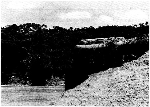
FIGURE 6.3 Trans-Ecuadorian pipeline severed by flood waters, E bank of the Aguarico River.
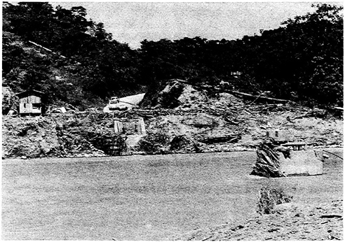
FIGURE 6.4 Trans-Ecuadorian pipeline on the W bank of the Aguarico River pulled southward by flood waters. Note the remnant pier and abutment of the bridge.
which was severed on the W side of the river at its junction between the bridge and concrete abutment. Figure 6.4 provides a view of the E side of the river where the pipeline had entered the bridge abutment as an aboveground structure. W of this location, the pipeline was pulled longitudinally and displaced off its supports for a distance of 4 km.
The highway bridge at the Salado River crossing was completely destroyed. The Trans-Ecuadorian pipeline at this location had been constructed by dredging a 3- to 4-m-deep trench in the river bottom, into which the line was placed and backfilled. The pipeline was encased in concrete to offset buoyancy effects. The pipeline was undamaged at the Salado crossing, and this segment of the line was incorporated without repair into the rebuilt pipeline system.
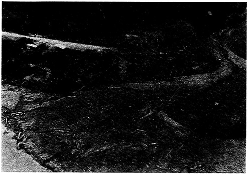
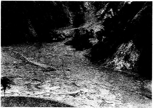
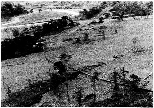
Figure 6.5 provides an expanded view of the area (hachured zone in Figure 6.2) of greatest pipeline damage. Approximately 12 km of the pipeline was destroyed along the banks of the Coca River, from just E of the Salado pump station to a location roughly 12 km E of the confluence of the Salado and Coca rivers. Along this section, damage was generated by landslides and debris flows in the residual soils and igneous parent rock of the hills flanking the N side of the Salado River. Most damage, however,
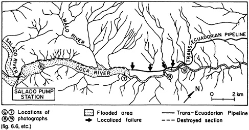
FIGURE 6.5 Area of flooding, landslides, and debris flows.
was caused by flooding of the Coca River, which is shown by the stipled area in the figure. Flooding encroached upon the pipeline alignment, resulting in severe scouring and removal of the entire pipeline right of way. Two sections of the pipeline, each approximately 1 to 2 km long, were left intact along this portion of the river. These sections were recovered during reconstruction and used on a provisional basis to establish flow in the rebuilt line.
As described previously, the 150-mm-diameter Poliducto Pipeline followed approximately the same route as the Trans-Ecuadorian pipeline. It was destroyed and damaged at approximately the same locations as the Trans-Ecuadorian pipeline.
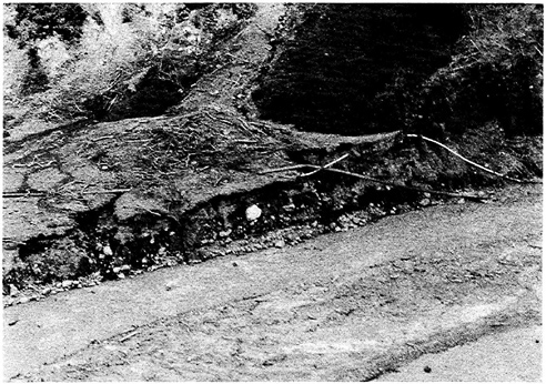
Approximately 5 km of the Trans-Ecuadorian pipeline, immediately E of the section described above, was damaged at locations where landslides and debris flows intersected the line. The black arrows in Figure 6.5 show the points of localized damage, where the pipeline was severed. Many landslides and debris flows in this section originated in the younger volcaniclastic deposits surrounding Reventador Volcano at elevations between 1,400 and 2,000 m.
The pipeline was severed by landslides and debris flows at two other locations approximately 7 and 10 km E of the area depicted in Figure 6.3. At one location, it was ruptured by a landslide in volcanic debris at a steep slope immediately adjacent to the line. At the other location, it was severed by a debris flow that originated as a landslide in a steep slope of thinly bedded shale.
Figure 6.6, Figure 6.7, Figure 6.8, through Figure 6.9 show photographs taken during helicopter reconnaissance approximately 3 weeks after the earthquakes. The locations of the photographs are identified as 6 through 9 in Figure 6.5, each corresponding to its respective figure number.
SALADO PUMP STATION DAMAGE
The Salado pump station is located near the confluence of the Salado and Coca rivers on terrace deposits at an elevation approximately 25 m above river level. At this location, alluvial sands, gravel, and cobbles extend to a depth of approximately 200 to 300 m below the floodplain of the Coca River (Almeida and Cruz, 1986).
A plan view of the station is shown in Figure 6.10. Severe damage in the station was caused by a landslide that occurred in weathered granodiorite and terrace deposits at an elevation roughly 80 m above the station. The debris from this slide traveled approximately 240 m to the E, where it ruptured the principal oil tank of the station and buried the main gate valve. The location of the landslide and the outline of the debris flow are shown in the inset diagram in Figure 6.10.
As shown in Figure 6.10, the Salado pump station is composed of several structures, the most important of which include the main gate valve, control building, generators, pump house, water tank, crude oil tank, communication equipment, and personnel housing. Each of these is labeled in the figure. The operational and physical characteristics of these structures and a brief description of their postearthquake condition is given under the headings that follow.
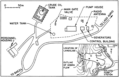
FIGURE 6.10 Plan view of the Salado pump station.
Main Gate Valve
The main gate valve controls the flow from the station and, therefore, controls downstream pressure in the line. It allows for isolation of the line in the event of difficulty. Debris from the landslide completely buried this facility. Because the remote control system of the station was lost, burial by debris prevented manual operation of the valve. As a consequence, an unknown but significant volume of oil in the line E of the pump station was lost by flow from ruptured sections W of the pump station.
Control Building
The control building was a one-story reinforced-concrete structure on a continuous concrete slab foundation. It contained the control equipment necessary for proper operation of the pump station. Visible damage to this structure consisted of a 12-mm-wide crack along the length of the controlroom floor slab. The control-room operators indicated that the switching panels had been damaged by the earthquakes. Electrical power was lost throughout the station immediately after the second main shock (M=6.9). Backup equipment and emergency generators failed to operate.
Generators
Two diesel-powered generators are used as the main source of electric power for the station. Approximately 12 mm of differential settlement and over 25 mm of horizontal displacement were observed at the concrete slab foundation of one of the generators. During site reconnaissance, approximately 3 weeks after the earthquakes, this generator was still under repair. In addition, one of the elevated diesel fuel tanks for the generators overturned as a result of the earthquakes.
Pump House
The pump house contained five diesel engine pumps, each supported on isolated concrete blocks and underlying 300-mm-diameter steel pipe piles. Soil settlement relative to the pile-supported blocks ranged from approximately 35 to 100 mm. This settlement apparently contributed to differential movement between the pump motors and the heat exchangers, which were supported on shallow spread foundations. This differential settlement caused distress in the rotating connections. Figure 6.11 shows the pump house during reconstruction of the station. In the photograph, excavation along the side of the structure has exposed the pile-supported block foundation.
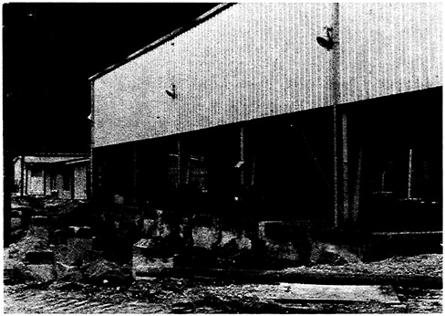
FIGURE 6.11 Pump house at the Salado pump station. Note soil settlement relative to pile-supported foundation blocks.
Communications Equipment
The main radio antenna buckled and became inoperable. This antenna was used to transmit continuous operations information and was the principal means of emergency communication.
Water Tank
The main 10-m-diameter water tank was 5.5 m high; it was constructed of approximately 7-mm-thick steel plate. Its purpose was to supply water for fire fighting. The 2,000-barrel tank was full at the time of the earthquake. As shown in Figure 6.12, wrinkling occurred near the top of the tank, apparently in response to sloshing. A large circumferential bulge, or “elephant's foot” buckle, developed at the juncture between the tank and its concrete ring wall (Figure 6.13). The main pipe outlet from the tank pulled free of a compression coupling, thereby disconnecting the tank from the station piping network.
Crude Oil Tank
The 15-m-diameter oil tank, which provides surge-pressure relief and oil storage, was about half full during the earthquake. The tank was con-
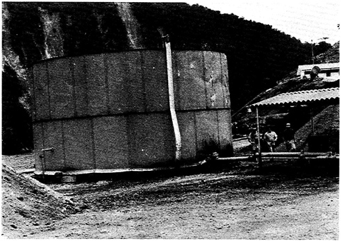
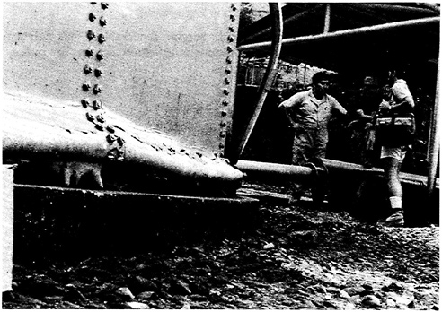
FIGURE 6.14 Oil tank destroyed by landslide debris at the Salado pump station.
structed of 12-mm-thick steel plate and was approximately 10 m high. Debris from the landslide hit the tank, causing it to collapse and to spill roughly 4,500 barrels of oil over the station. Figure 6.14 shows a photo of the collapsed oil tank and two smaller fuel tanks that were destroyed by the landslide and debris flow. Excavation and inspection during reconstruction revealed that oil from the tank had seeped through the ground to the Coca River over 100 m away, infiltrating subsurface soils for a depth of approximately 10 m. An oil fire erupted near the location of the ruptured tank during reconstruction of the station about 2 months after the earthquakes.
Personnel Housing
The barracks and mess halls were one-story reinforced concrete structures. Severe cosmetic damage was observed throughout the housing. Some structural damage to the reinforced concrete beams in the mess hall was also observed.
TRANS-ECUADORIAN HIGHWAY FROM BAEZA TO LAGO AGRIO
The road parallel to the pipelines (Figure 5.1, Figure 6.1, Figure 6.2) is the main transportation artery from Quito to the eastern oil field. Flooding destroyed the highway bridges at the Salado and Aguarico rivers as well as
large portions of the road between the Salado and Malo rivers. More than 6 months after the earthquakes, this road was still disrupted, and the eastern region still experienced shortages of supplies because of the loss of this transportation lifeline. The only alternative means of transportation to Lago Agrio were by plane or by a combination of road and river travel. (The Salado River bridge was replaced in 1988 by a “Bailey” bridge, which currently is in use.)
ECONOMIC CONSEQUENCES
Loss of the Trans-Ecuadorian pipeline deprived Ecuador of 60 percent of its export revenue. As a consequence, the loss of this single lifeline had a dramatic effect on the country's economy. Assuming that the pipeline could transport roughly 250,000 barrels daily at an average price of $19 per barrel, the total lost revenue from March 5 to the first provisional use of the reconstructed line on August 18, 1987, was approximately $790 million. The cost of pipeline reconstruction is estimated at approximately $50 million.
The price of West Texas intermediate crude oil is often used as an index of the world oil price. News of the earthquakes and associated loss of the Trans-Ecuadorian pipeline was followed by a 6.25 percent increase in the price of West Texas crude oil over the 4 trading days immediately following the earthquakes. Although oil prices had been climbing at the time of the earthquakes, market analysts claim that the news of Ecuador's suspension of oil exports encouraged trading at escalating prices. As a consequence, the economic effects of the lifeline failure were not confined to a single country, but were felt worldwide through market speculation.
SUMMARY
Earthquake damage to the Trans-Ecuadorian pipeline represents the largest single pipeline loss in history. Even though the March 5, 1987, earthquakes occurred in a remote region, their consequences in terms of lifeline failure had significant national and international ramifications.
Seismic shaking had only a limited effect on the line pipe, whereas permanent ground deformations had a severe and extensive influence. Landslides and debris flows caused most of the pipeline damage and contributed to virtually all ruptures and permanent deformations of the line. Damage from landslides and debris flows was caused directly by failed soil or rock material that intersected the line, or indirectly by rivers swollen with debris that flooded the line and eroded the pipeline right of way.
Pump station damage at Salado was extensive. Nearly all pump station systems failed to operate properly after the earthquakes. The most severe
structural damage was caused by a landslide that destroyed the crude oil tank at Salado, spilling thousands of barrels of oil across the station. Permanent differential settlements and horizontal displacements were observed at most building foundations and were responsible in part for malfunctioning of control equipment, connections between pumps and heat exchangers, and generators. Seismic shaking damage was especially severe at the water storage tank and radio communications antenna.
ACKNOWLEDGMENTS
This study was made possible thanks to the logistical support of CEPE/ Texaco, Inc. Special thanks are extended to several employees of CEPE/ Texaco, Inc.: Dr. Juan Quevedo, General Manager; Mr. Bob Paulsell, Assistant Superintendent; Mr. Bill Spear, Chaco Camp Superintendent; and Mr. Jerry Isacks, Quito Superintendent. Mr. Gustavo Freile of Harbert Engineers provided critical assistance during both reconnaissance visits. Mr. Ivan Nunes of INECEL provided valuable information. We thank Messrs. “Swamp” Smith and Bill Spencer of Will Bros. Construction Company for their assistance and hospitality. We express our gratitude to Capt. Francisco Hidalgo of Ecuador's Army Aviation. Special thanks and recognition are given to Prof. John M. Bird of Cornell University for his assistance and insight during the second reconnaissance trip.
REFERENCE
Almeida, E. and M. Cruz . 1986 . Estudio geológico del Volcán Reventador, INECEL, Proyecto Geotérmico , Quito .


