


Below is the uncorrected machine-read text of this chapter, intended to provide our own search engines and external engines with highly rich, chapter-representative searchable text of each book. Because it is UNCORRECTED material, please consider the following text as a useful but insufficient proxy for the authoritative book pages.
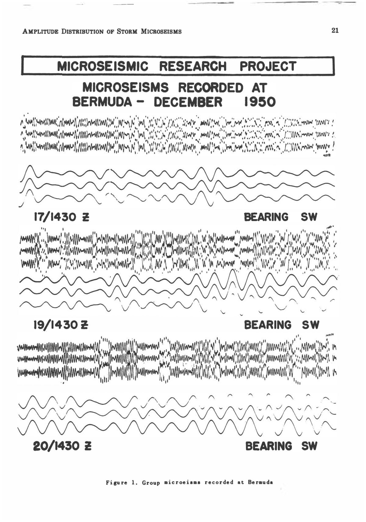
AMPLITUDE DISTRIBUTION OF STORM MICROSEISMS MARION H. GILMORE U. S. Naval Air Station, Miami, Florida AbstractâThe work of the Microseismic Re- search Project has been carefully reanalyzed in an effort to determine as many facts as pos- sible concerning the nature of microseisms and their possible operational value in detecting and tracking severe tropical storms. From these data there is no longer any doubt that dominant group microseisms are generated by various types of meteorological disturbances over the oceans. It is still impossible to track storms by means of cross bearings from tri- partite stations. A new method has been de- veloped by the Navy Microseismic Research Project that permits accurate tracking of storms that are far from land. This micro- ratio technique of storm tracking is entirely independent of microseismic bearings from tripartite stations, or geology of the earth's crust, or theories concerning microseism gen- eration; it is dependent only upon the ampli- tude of microseisms actually recorded from a storm at sea. It is possible, by the use of special microseismic charts, to detect, to track, and to determine changes in the intensity of a storm when it is within range of three or more microseismic stations. The Problem of Recording Storm Microseisms âThe Naval Aerological Service initiated the Microseismic Research Project in 1943 with one major objective, which was to determine if severe tropical storms could be detected and tracked by recording changes in the amplitude and period of microseisms. Rapid progress is now being made in solving this problem. The many new data obtained over a period of eight years by recording microseisms generated by several hundred tropical storms in the Pacific and Caribbean aid in verifying certain theories concerning the origin and method of propaga- tion of storm microseisms. However, this pa- per will present only the details of the new Micro-Ratio technique of storm tracking and give facts and figures showing the degree of ac- curacy obtained by these methods in forecast- ing tropical storm movements. The Microseismic Research Project uses Sprengnether type, horizontal component, elec- tromagnetic seismometers with natural periods of approximately 7.0 seconds. Both the seis- mometer and the galvanometer are critically damped and of exactly the same period. In order to standardize the work at each station the magnification is held rigidly to 5,000 for ground motion with periods between 3 and 5 seconds, and each seismometer is orientated in a N-S direction. A trace up on each record represents an east movement of the ground. There are now 24 such instruments in opera- tion at three single and six tripartite stations in the southeastern United States, the Carib- bean, the North Atlantic and the Western Pacific. The data derived from records made on properly calibrated seismometers are trust- worthy in all respects, as in Figure 1, which shows similar microseisms recorded at Ber- muda on three different days from instruments one-half mile apart. This high degree of stand- ardization is maintained at each station and is the same year after year. There are many classes of microseisms re- corded on seismographs but the type generally called "Group Microseisms," Figure 1, is the only class discussed in this paper. Macelwane [1951] says: "These microseisms are regular in wave form and appear in a succession of groups of a few large waves, each with short intervals of slight motion between the groups. They do not appear at all times but in dis- creet sequences which may last for a period of hours or days, building up to a maximum and dying down again. Such a sequence has come to be known as a microseismic storm." There is no longer any doubt that these storm micro- seisms are generated by various types of me- teorological disturbances, but there is yet no complete agreement on the exact manner in which energy derived from the storm is trans- ferred from the storm to the ground. How- ever, it may be pointed out here that the newly developed technique of using the amplitude of microseisms to detect and track tropical storms is valid regardless of the method of gen- erating storm microseisms. Group microseisms are always recorded at each Navy seismograph station as soon as a generating source, such as a hurricane or cold front, comes within range of a station. Since this has happened hundreds of times in the past eight years at one or more of the microseismic stations it is now possible to describe certain outstanding characteristics of storm micro- seisms. These facts are all the more note- worthy because they also direct attention to the important problem of "How microseisms 20
AMPLITUDE DISTRIBUTION OF STORM MICROSEISMS 21 MICROSEISMIC RESEARCH PROJECT I MICROSEISMS RECORDED AT BERMUDA- DECEMBER 1950 K^f^^ W3i^H&Xy^ fiBnMNSKlw 17/1430 Z BEARING SW i..'. '''.. i,r. ⢠M^^ TO^r-wwr;? * n i* f w 'x v v ^ v^"» 'v fV f xs - , ,' I. I " i ,.' ' " i .' ' A'i, "_'''i ' i '" ' 'il ' ' ' 19/14 30 2 BEARING SW MNUM* i f i ^ 20/1430 Z BEARING SW Figure 1. Group microeisms recorded at Bermuda
22 SYMPOSIUM ON MICROSEISMS are generated," and throw considerable light on its solution. Hurricane MicroseismsâThe first method at- tempted was to determine if tropical storms could be located within operational accuracy by microseismic cross-bearings from two or more tripartite stations. It is possible, with microseisms from a tripartite station such as shown in Figure 1, to calculate accurately the direction they are traveling when passing over a station. If microseisms from tropical storms were always propagated outward in concentric circles it would be very simple to determine their exact origin and the location of the storm by means of cross-bearing from two or more tripartite stations. But accumulated data show that microseisms do not always travel in straight lines, often resulting in large errors in tracking tropical storms, Figure 2. The tripartite cross-bearings proved unsatisfactory because the bearings pointed to the area of a storm only when it was traversing regions that Jay in specific directions from a microseis- mic station, such as south and west of Guan- tanamo Bay, Cuba. It was therefore necessary to seek a new and different technique for solv- ing the problem: one that would be completely independent of the method of generation and propagation of microseisms. Facts derived from microseismic records over a period of many years led the way to the development of a new and important technique for detecting and forecasting the movement and intensity of hurricanes and typhoons. This new method consists only of using observed microseismic data with little or no regard to the physical processes involved in their generation. The amplitude and micro-ratio charts were first constructed in 1950 and recent results indi- cate that detection and tracking of severe trop- ical disturbances is well within the necessary operational accuracy. The tracks of six hurricanes are drawn in Figure 3, and along each track are listed the corresponding amplitude of recorded micro- seisms in mm on top of line and the intensity of the storm in knots on the bottom. The storm intensities and corresponding microseismic am- plitudes are very consistent throughout the map, especially at points where the tracks cross BEARINGS CALCULATED FROM STORM MICROSEISMS 1800 2 19 AUGUST 1950 61* ERROR MIAMI WHITING FIELD EACH LINE REPRESENTS THE BEARING OF AN INDIVIDUAL WAVE, EACH GROUP OF LINES A BUILDUP Figure 2. Microaeismic directions obtained at Tripartite Station
AMPLITUDE DISTRIBUTION OF STORM MICROSEISMS 23 US. NAVY MICRQSEISMIC Figure 3. Hurricane tracks around Miami each other and for the beginning of first in- crease in microseisms. From such data it is possible to draw lines of equal microseismic amplitude for a storm of any intensity around a station where sufficient storm microseisms have been recorded. The lines of equal ampli- tude around Miami for a 90 knot storm are shown in Figure 4. It will be noted that these lines cross Florida and that some storms con- tinued with 90 knot winds. Considerable perti- nent information concerning a storm can be obtained from such amplitude charts. It is an early warning for any station because it is impossible for a 90 knot storm to exist inside the 10 mm line on seismometers standardized by the Microseismic Research Project and not cause the ground to move or shake sufficiently to make microseisms of 10 mm in amplitude. This, therefore, makes the seismograph a one hundred per cent detector of severe tropical storms, regardless of all other types of infor- mation. Storms of greater than 90 knot winds will register the 10 mm amplitude of micro- seisms a greater distance from the station so that such lines can then be drawn for storms of any intensity. After a storm comes within range of Miami by crossing the 10 mm line, its intensity can be determined by plotting the position on the 70, 90, 110, or 130 knot am- plitude chart. When a particular amplitude chart agrees with the location of the storm and the amplitude of the microseisms, then the in- tensity on that chart is very close to the actual intensity of the storm. Ten knots, more or less in the intensity of a severe storm will make little difference in its destructiveness to life and property. The amplitude lines drawn in Figure 4 are valid for storms moving in any direction in re- lation to Miami. This suggests that the source of microseisms cannot be along the coast or continental shelf because, were this true, a hurricane approaching Florida would undoubt- edly cause larger microseisms than a storm leaving Florida. The lines around Miami are very similar to those around all other stations in that none are concentric with the station in the center. They tend to run close together on one or two sides of a station and are more
24 SYMPOSIUM ON MICROSEISMS us NAVY MirRQSFISMIC RESEARCH PROJECT FOR 90 KNO Figure 4. Amplitude chart for 90 knot storms in range of Miami widely spaced on the other sides. Each storm passing a station inside the 10 mm line devel- ops the same characteristic type of storm mi- croseisms and will fit one of the amplitude charts, depending only on the intensity of the storm and its distance from the station. Simi- lar storms, in passing over the same area as a previous storm, will generate point by point the amplitude of microseisms as shown on the chart. Microseisms recorded simultaneously at four stations located between 190 and 740 miles from the storm center produce storm mi- croseisms of a uniform character, regardless of the direction of the storm from the station, Figure 5. Any similar storm in the same lo- cation will duplicate these microseisms at the four stations, provided the instruments are maintained in the finest of calibration and at a standard magnification. Use of Amplitude ChartsâThe Fleet Weather Centrals at Guam and Miami direct aircraft to fly reconnaissance into and around tropical storms, when they are far from land. Some reconnaissance planes are now equipped with radar for tracking storms at night, but be- cause of various interferences these radar re- ports are not always reliable. Valuable time is consumed in alerting the planes, flying to the storm location and transmitting reports. Occa- sionally a storm far from an airfield cannot be tracked, other than by extrapolation, because the planes have been grounded for various rea- sons : chiefly, mechanical trouble. Ship reports are often just as valuable, when available, but once the storm is located ships are warned to stay clear of the storm area and consequently give little additional information. The Fleet Weather Centrals at Guam and Miami have been using the data from micro- seismic records for several years as a helpful aid in forecasting the intensity and movement of tropical storms. There are many specific cases in which microseisms have given valuable information that could be obtained in no other way. The type of pertinent storm information furnished by the amplitude chart is adequately
AMPLITUDE DISTRIBUTION OF STORM MICROSEISMS 25 â¢NMWt* V* "⢠«. HC WHITING FIELD MICROSEISMIC RESEARCH PROJECT omm feMiD i H. M. fin tie. CHERRY POINT £^ "/' â¢- .-. ,â¢â¢; V / ⢠,-" -IT/ â¢,,â¢" ,.v"/Vâ¢',:,..â¢â¢"/" .â¢â¢-,â¢,â¢'â¢/. â¢â',,'..,' I â¢',â¢,;⢠;â¢;,>⢠I1â¢;'â¢"â¢'" ,. , y,, , I * ' I wtio '^ U.K. rtn nc JACKSONVILLE 0*IM tPtU fc X ⢠HI MO. , - . . â¢- . ⢠.1 ⢠. .â¢â¢â¢-- -...-.⢠-- ... . . . \ . .- COMPARISON OF MICROSEISMS RECORDED SIMULTANEOUSLY AT FOUR STATIONS DURING AUGUST 1950 HURRICANE Figure 5. Group microseisms simultaneously recorded at four stations illustrated in Figure 6 for a 1950 storm. Neith- er aircraft nor ship reports were available for a period of 42 hours from 7 September 1230 GCT. The forecasting agencies were left with no alternative but to rely entirely on micro- seismic data from Bermuda to make forecasts of the movement and intensity of the hurri- cane. Because of a large high pressure cell building up to the north, upper right of Figure 6, a continued northward movement was un- likely. An amplitude of 30 mm was recorded at 1200 GCT, 7 September, lower right of Fig- ure 6, at which time the storm was reported by aircraft to have 100 knots of wind and its position as reported was located between the 35 and 40 mm lines on the 90 knot amplitude chart. That position and the 100 knot wind agreed with the amplitude chart because the 100 knot storm was located just outside the 30 mm line of a 90 knot chart. A maximum amplitude of 44 mm was reached at 0300 GCT on 8 September and, within an hour, it de- creased 6 mm. The storm could not move north because of the high cell; it could not move west without causing an increase in mi- croseisms at Cherry Point. The only forecast possible to make, from microseismic data, was that the storm was drifting slightly northward and slowly filling. This forecast was fully verified at 0630 GCT on 9 September, when the storm was located by a radar plane and found to be between the 45 and 50 mm lines, with only 75 knots of wind. The microseisms were only 37 mm in amplitude. The storm then moved westward, causing Bermuda amplitude to drop rapidly, while that at Cherry Point started increasing. It might be pointed out here that a 100 knot storm was within 600 miles of the coast for three days, yet no in- crease in microseisms were recorded at Cherry Point nor Jacksonville, despite the fact that storm-produced swells had ample time to reach the coast. The tracks of three typhoons passing through the area between Guam, Manila and Okinawa are plotted on map, Figure 7, together with the corresponding amplitudes of microseisms recorded at the three stations. Typhoon Rita developed as a strong tropical depression late in 1948, west of Guam and continued westward. The Guam, Okinawa, and Manila amplitude chart, lower left of Figure 7, shows a very slow increase in microseisms until the 1200 GCT
26 SYMPOSIUM ON MICROSEISMS report of 6 November. At that time the storm quickly developed into a typhoon with winds in- creasing from 55 to 100 knots in the next 24 hours. A simultaneous sharp increase in mi- croseisms occurred at all three stations but was greater at Okinawa because the storm was nearer that station. This increase occurred at all stations long before storm swells from the intensified winds around the storm could possibly build up and travel the great distances to the three stations. Typhoon Patricia in October 1949 was a small tropical storm with only 35 knots of wind when it passed Guam on the 20th. This storm also rapidly developed into a typhoon with 90 knot winds, starting about 2400 GCT on 23 October. The microseisms increased rapidly at all three stations when the storm was about 740 miles from each station. The maximum increase was greater and a day later at Okin- awa because the storm was approaching that station and crossing increasingly larger lines of equal microseismic amplitude. Here again it was physically impossible for the intensified swells to reach the three land masses and ac- count for the rapid increase of microseisms on 24 October. Almost one month later typhoon Allyn passed south of Guam on 17 November and the seismograph registered microseisms of 240 mm in double trace amplitude. The micro- seisms fell rapidly to 83 mm as the storm moved westward and the winds decreased to 80 knots by 1200 GCT on 20 November. This typhoon suddenly intensified when it was located by aircraft at a midway point about 740 miles from Guam, Okinawa, and Manila. The si- multaneous sharp increase in microseismic am- plitude at the three stations, lower right of Figure 7, again occurred before storm gener- ated swells could build up after the storm in- tensified and travel the necessary 740 miles. The rapid intensification of the three ty- phoons was identical with the sharp increase of microseismic amplitude at each station. It may be pointed out here that these three ty- phoons generated very large microseisms at three stations 740 miles away in three different directions; yet a very similar storm was with- in 600 miles of Cherry Point for three days without causing the slightest increase in am- plitude. Each storm was moving away from Guam when the microseisms suddenly in- creased in amplitude; i.e. the storms were US. NAVY -MICRO CH PROJECT Figure 6. Forecasting movement of storm by microseismic amplitude at Bermuda
AMPLITUDE DISTRIBUTION OF STORM MICROSEISMS 27 US. NAVY MICRQSFISMIC RESEARCH PROJECT. MICROSEISMIC AMPLITUDE CHARTS GUAM QWN/QWA MANILA Figure 7. Forecasting movement of storm by microseismic amplitude at Guam, Okinawa and Manila crossing decreasing lines of equal amplitude, and the microseisms should have been decreas- ing if the intensity of the storm had remained constant. The fact that the observed micro- seisms were too large at each station to fit the proper amplitude chart gave every evidence that the storms were increasing in intensity. Microseismic stations can detect tropical storms long before their existence can be de- termined except by direct observation by planes or ships. This priority of detection is some- times difficult for the Carribbean stations be- cause of the presence of many islands with weather facilities between the possible source
28 SYMPOSIUM ON MICROSEISMS of storms and a recording seismograph. Nev- ertheless it has been accomplished. Figure 8 shows an example of early storm detection. The left side of the picture shows a portion of the Caribbean just south of the west end of Cuba, where the synoptic situation was not conclusive as to the existence of a hurricane. On the basis of an abrupt increase in micro- seismic amplitude at Swan Island, a weather plane was sent to investigate the area and the situation shown in the right side of the pic- ture was found to exist. This storm developed rapidly and the intensification was immediate- ly registered by the Swan Island seismograph before any other sort of warning, such as in- creasing swells or winds, reached Cuba, Swan Island, or Yucatan. Property located seismo- graphs would always give similar advance warnings. In other words, it would be im- possible for a storm to develop into a danger- ous hurricane or for a fully developed hurri- cane to approach a seismograph station with- out giving sufficient warning to permit the carrying out of all necessary precautions. The seismograph at Guam often detects typhoons long before they are otherwise known. More- over, a microseismic station in an area which is homogeneous with that over which the storms are traveling, can observe immediately, from an increase or decrease in the amplitude of the microseisms, any changes in the inten- sity of the storms being tracked. Tropical storm How in October 1951 was first deter- mined to be a hurricane by the rapid increase of microseisms during the night at Miami and Jacksonville. Even when the synoptic reports indicated that the storm was apparently filling, the seismographs at Jacksonville and Cherry Point showed that it continued to be attended by 90 knot winds. This feature of storm de- tection, that of giving a good estimate of storm intensity, is an especially valuable aid in the forecasting of hurricanes, especially at night and at other times when there are no direct observation by planes and when no ship re- ports are available. The Micro-Ratio ChartsâThe microseismic am- plitude charts are primarily used for detection of storms, and after the storms are located, to 18001 1 SEPTEMBER I»80 MBER 1980 DATA) Figure 8. Early detection of hurricane by microseismic amplitude increase at Swan Island
AMPLITUDE DISTRIBUTION OF STORM MICROSEISMS 29 Figure 9. Micro-ratio chart between Jacksonville and Cherry Point find their intensity. Amplitude charts, there- fore, are very important in storm forecasting. The micro-ratio technique mentioned briefly before, is still another step forward in the tracking of severe storms. This technique can be used independently of the amplitude charts, but the two together can give all the informa- tion necessary for detecting and tracking of a storm and for finding its intensity. The technique involved in the construc- tion of micro-ratio charts is based upon the observed fact that a storm at any specific place will cause the amplitude of the microseisms at two recording stations to be in a definite ratio to each other regardless of the intensity of the storm, the geologic formation through which the microseisms pass, or the distance of the storm from the station. It is important to note that this technique does not presuppose anything concerning the method of generation or of propagation of microseisms, since one hurricane at any particular place will generate and transmit microseisms in the same manner as any other hurricane in the same place. For example, when the first storm of 1950 was lo- cated at 39 °N and 70 °W, the ratio of the mi- croseismic amplitudes between Cherry Point and Jacksonville was 2.5. The fourth storm of the year, one of less intensity, passed over
30 SYMPOSIUM ON MICROSEISMS COMPARISON BETWEEN MICRO RATIO LINE FIXES AND AIRCRAFT RECONNAISSANCE FIXES CHERRY POINT~JAX ⢠MIAMI~CHERRY PT. JAX~ MIAMI \ CO/12801 \ HURRICANE *l AUGUST I960 Figure 10. Hurricane tracked by micro-ratio technique in 1950
AMPLITUDE DISTRIBUTION OF STORM MICROSEISMS 31 US. NAVY MICROSEISMIC RESEARCH PROJECT ^Boi/0400 MS) 100 M9 MICRO-RATIO FIX A AMCftAFT FIX O WIND FORCE IN KNOTS ( ) HURRICANE "HOW" OCTOItB l»»l JL A/l (3 <c* . Tfc f* * 1f *? ' i ' i 1 Figure 11. Hurricane tracked by micro-ratio technique in 1951 r"-i the same point and smaller microseisms were recorded at each station, but the ratio of their microseisms was again 2.5. This fact has been observed at all other points for which reliable data are available. A chart utilizing such data can be made by plotting on a map lines through all points of equal ratio, Figure 9. Thus any storm gener- ating microseisms that are recorded simultane- ously at the two stations must be located along the ratio line on a chart corresponding to the ratio of the amplitude between the recorded microseisms at the two stations. Similarly, a ratio between either station and a third sta- tion can also be computed and the intersection of the two ratio lines will fix the position of the storm, Figure 10. Naturally, when other sta- tions record microseisms generated by the same storm, the additional computed ratios will greatly improve the accuracy of the fix. This method should locate and track a storm in any area when three or more micro- semic stations record vibrations solely from the storm, regardless of the storm's intensity, posi- tion, its size of its -method of generating mi- croseisms. The final accuracy of any micro- ratio fix will depend principally upon the amount and reliability of accumulated storm data used in making the ratio charts between each pair of stations and the number of stations recording the storm simultaneously. An exam- ple of the accuracy that has been obtained is demonstrated in Figure 10 for hurricane ABLE in August 1950. The five positions plotted along the storm track were taken from the Fleet Weather Central's final history of the storm. The micro-ratio fixes corresponding to the ac- tual storm positions are shown as the intersec- tion of the three ratio lines. This was the first attempt to use the micro-ratio charts and re- sulted in positions not far from the true location of the storm. The results of the second attempt is shown in Figure 11. This shows the storm track, plot- ted from advisories issued by the Fleet Weath- er Central, and the track plotted from micro-
32 SYMPOSIUM ON MICROSEISMS ratio technique. The micro-ratio fixes were, for the first time, released along with the Weather Central advisories. The two tracks are almost identical. Hurricanes ABLE and BAKER in August and September 1952 gave additional proof that the new technique of storm tracking is a very valuable tool for the forecaster of tropical storms. Accurate infor- mation as to the location and intensity of these storms were derived from microseismic charts. The validity of such amplitude and micro- ratio charts is naturally dependent upon the ac- curacy of the data-used in determining the in- tensity of past storms. Wind force is difficult to estimate, especially the higher velocities, and is often as much as 10 knots in error, even in some aircraft reconnaissance reports. If it were always correct, it would still be only a rough gauge of the relationship between the to- tal energy of the storm and the amplitude of the microseisms produced at each station. Also there is the stipulation that no other major source of microseismic generation, except the hurricane, be influencing the station. This, of course, can be assured only by the placement of additional single microseismic stations through- out the entire hurricane belt in such numbers that stations influenced by other sources would not have to be depended upon. These data in- dicate that, when a proper network of micro- seismic stations is available, it will then be pos- sible to detect and track any and all tropical storms. Conclusions The data presented in this report clarify and solve to some extent some of the problems involved in microseismic storm de- tection and show what is necessary for the fu- ture microseismic forecasting of tropical storms. The primary problem of detecting and tracking tropical storms with microseismic data appears to be near solution with the newly de- veloped micro-ratio technique. Even a few sec- ondary problems concerning the actual method by which energy is transmitted from a storm to the ocean floor and then propagated in the form of microseisms may be near solution. There are three important items concerning the funda- mental problem of complete microseismic storm detection to which attention is invited. A. Early Tropical Storm Detection. From all the information obtained in the research there is no longer any doubt that the seismograph, when properly located in rela- tion to a tropical storm, can detect the storm when it is over water. The effect of apparent irregularities in the earth's crust that tend to impede microseismic transmission can be great- ly minimized, if not altogether eliminated by placing seismograph stations on each side of all known "microseismic barriers." Early storm detection is obviously a valuable aid to any hur- ricane warning system and it is very probable that the present operational network. A suffi- ciently close network of such stations would, in addition to giving early warning of a storm, greatly aid the weather centrals in scheduling flights into suspicious areas. B. Tracking Tropical Storms. The newly developed micro-ratio technique for tracking tropical storms is based entirely upon an empirical use of microseisms and for that reason is not influenced in any manner by changes in geologic formations between the storm and the observing station nor by the size or intensity of the storm. The accuracy ob- tained in tracking past hurricanes, if main- tained with future storms, could fulfill opera- tional needs. These hurricanes were the first storms passing within range of three or more microseismic stations since the new technique was developed. If this high degree of accuracy can be obtained again with this same group of stations and with new stations in other areas, it would, without doubt, be a long step towards the answer to the original problem in tropical storm tracking. C. Detecting Changes in the Intensity of a Storm. It is just as important to know whether or not a hurricane is intensifying, when approach- ing a populated area, as it is to know its approx- imate position. For this reason alone the ampli- tude charts are of prime importance in hurri- cane forecasting. The amplitude charts give far more accurate information on storms than merely moving them along at a constant for- ward speed, when weather reports are not avail- able. This is especially true at night when no reconnaissance can be made. It is obvious that information from such charts will become more valuable as the charts are improved by increas- ingly accurate data from future storms and as the number of effective stations is increased. REFERENCES MACELWANE, J. B., S. J., Practical application of micro- seisms to forecasting, Compendium of Meteorology, Amer. Met. Soc., 1951. U. S. NAVAL AIR STATION, MIAMI, FLORIDA. Discussion D. S. CARDER U. S. Coast & Geodetic Survey The technique that was just presented by Mr. Gilmore on the use of empirical amplitude relationships of storm microseisms as a method of tracking tropical storms is highly interesting and shows promise. However, a large amount of observational data is needed before its use- fulness can be verified. The method, to be re- liable, needs precision calibration of the instru- ments, as was outlined by Mr. Gilmore; and in
AMPLITUDE DISTRIBUTION OF STORM MICROSEISMS 33 addition, data from storms traveling in differ- ent directions over different though intersecting paths must be checked against one another, so that if a storm is over any given point in the ocean the amplitude ratios recorded at any two stations used in the net must be the same regardless of the direction of approach of the storm to that point. Presumably this condition has been met by the Microseismic Research Project and if the method has been proven by independent observers, there is little room for adverse argument. Although Mr. Gilmore favors the idea that storm microseisms which are recorded in force on land are generated beneath the eye of the storm, he nevertheless reports that the ampli- tude relationships at the several stations will hold regardless of how the microseisms are generated. I concur with Mr. Gilmore only up to a certain point. If the microseisms are generated on the ocean bottom beneath the storm, then barring extraneous sources, the amplitude ratios at two stations should be about the same. Further if two storms approach a given spot in the ocean from the same direction and the microseisms are caused as a result of the fetch reaching the nearest shore, then ampli- tude relationships should also hold. But if the Figure 1. Paths of 3 hurricanes; A, B, C, passing over point Q producing microseisms recorded at stations S and $.,. SASKATOON SITKA JANUARY 15-16 1950 SEVEN FALLS QUEBEC Figure 2. Storm microseisms from an east coast source recorded at representative North American stations.
34 SYMPOSIUM ON MICROSEISMS storm approaches the point from different di- rections, unless it is far at sea, amplitude ra- tios as a means of locating the storm center would hardly be expected to be reliable because in the two cases swells generating the micro- seisms would generally reach the shore at dif- ferent points. Consider for example three hurricanes, A, B, and C, Figure 1, which in the course of their history had passed over point Q. Suppose that microseisms were gen- erated near the shore as a result of the fetch from the hurricanes reaching the shore at R,, RB and RM leaving the storm areas at P,, P,, and P,, the storm in the interim having moved to Q. In the illustration R, and R, are close to- gether and would be expected to yield nearly the same microseismic ratios as stations S, and S,, but in case C, R3 is closer to S, and the am- plitude ratio S3/S, would be relatively larger, although other things equal, the microseisms would be much smaller. Past and future verification of the am- plitude ratio technique of every circumstance may possibly verify the contention that hurri- cane microseisms are generated under the ocean beneath the storm area. But I have strong evidence that this condition does not generally apply to extra-tropical storms in the western half of the Northern Hemisphere. I will now outline the case history of 5 cyclonic storms of the past three winter seasons and will show that microseisms generated in con- nection with these storms are not by virtue of the position of the storm over the ocean, but more probably by virtue of strong winds on the shore-directed limb of the storm while the storm may have been as far as several hun- dred miles at sea. The microseisms, however, may appear on land as much as 48 hours later after the swells generated by these winds have had time to reach the shore or meet oppositely moving swells generated by an earlier or later storm. The storm in the meantime may have moved inland or far at sea, or it may have be- come dissipated. Source of data. In this study the data are from long or intermediate period seismo- graphs operated by the U. S. Coast and Geo- detic Survey and cooperative institutions. Data from cases 1 and 3 are also from the stations of the Canadian network; the Berkeley and Pasadena nets, and from individual stations at St. Louis, Cleveland, and Bermuda. Most of the Canadian and Coast and Geodetic Sur- vey data are from direct-recording seismo- graphs and are therefore non-selective to the periods under study. Source location and transmission of micro- seisms. We will first make two basic assump- tions. Figure 2 are shown cross-sections of records from representative stations arranged in order from east to west across North Amer- ica. The solid lines connecting the records represent the same hour. The records show a microseismic buildup beginning, peaking, and ending about the same respective times. On most records, the normal, background period was 4 or 5 seconds before and after the build- up. The period on all of the records was 6.0 sec. At the beginning and 6.5 to 6.8 sec. dur- ing the peak of the buildup. It will be as- sumed therefore that these microseisms were generated in the same general area; and since the amplitudes from east to west were pro- gressively from relatively large eastward to relatively small westward, it will be assumed that this area was on or off the east coast. It follows that microseisms were trans- mitted from the east coast to the west coast with low attenuation and with no material in- crease in period. The records shown here are representative of all North American stations, parts of Cali- fornia excepted. The history at Pasadena paralleled that of other North American sta- tions. Berkeley and Ukiah, on the other hand, although they recorded 6 + sec. periods among others as part of the normal background, re- corded no increase in amplitude nor a concen- tration of 6 + sec. periods during the time of the buildup at other stations. Reno and Fres- no have short-period instruments. Reno re- corded definite 6+ sec. periods during the storm, but not before or afterward. Fresno definitely recorded a 6 + sec. period on the ver- tical and indefinitely on the horizontal compo- nents. It follows that the Rocky Mountain sys- tem transmits 6 + sec. microseisms from east to west, although not as well as the eastern lowlands perhaps. Furthermore, it follows that the Sierra Nevada, or more likely the Cen- tral Valley of California because of its deep sedimentary rocks, may possibly be an effec- tive barrier to these microseisms. During this time there was only slight evidence of a 6 + sec. period in very faint waves during lulls in local microseismic activity at Bermuda where the dominant periods were 4-5 sec. There was no evidence of a 6 + sec. period at San Juan. Bermuda is closer to any east coast area than Saskatoon, yet 6 + sec. microseisms at Saska- toon were quite strong. The North Atlantic, therefore, apparently absorbs 6 + sec. micro- seisms. Figure 5 shows an arrangement similar to that of Figure 2 except that amplitudes are relatively much larger on the west coast, more specifically on the northwest coast, than to- ward the east. The parallelism in amplitude buildup shown here was characteristic of all North American stations except Pasadena and perhaps Ukiah and Tucson. Before and after the amplitude buildup the period was some- what less than 7 sec. at most places. During
AMPLITUDE DISTRIBUTION OF STORM MICROSEISMS 35 the peak the period was about 8 sec. at Sitka and 8.5 sec. elsewhere including Victoria, Ukiah, and Tucson, but not including Pasa- dena. There was no evidence of an 8 + sec. period at Honolulu at this time. Again it may be assumed that the micro- seisms during the peak activity at all stations where 8 + sec. periods were dominant had a common source area, and that in this case the area was near the west coast, more specifically nearer Sitka than Victoria, for instance. This series of records indicates that these microseisms may undergo a slight increase in period during the first few hundred kilometers of their journey, but thereafter they continue across the continent, including the western mountain systems, with no material change in period. Since Berkeley records microseisms Figure 3. Weather chart of North America for 15 January 1950 at 18h 30m GCT showing a storm moving off the coast of labrador which is believed responsible for the generation of the micro- seisms shown in figure 2, courtesy of U. S. Weather Bureau.
36 SYMPOSIUM ON MICROSEISMS from this source and Pasadena and Honolulu do not in this case, there is additional support for the idea advanced earlier than the Cen- tral Valley of California and the ocean basin, in this case the North Pacific, absorbs these microseisms. It should be noted that conclusions reached in this section imply only that the North Amer- ican continent, with one or two exceptions, is a good transmitter of microseisms and that the adjoining ocean basins are not; and except at the very first, the period does not increase with distance. No inference as to source or source mechanics was made except that the location was in a general area near one coast or the other. The relationship of these and other se- lected microseisms to weather conditions will now be presented. Case I. On January 15, 1950, a violent Figure 4. Weather charts 19-21 December 19 50 showing a storm moving off the coast of northeast North America and microseisms recorded at Chicago during this time. In this and other illus- trations, the flags show wind velocity in 10 knot intervals and the numerals represent days, hours and minutes. Isobar interval is 5 millibars.
AMPLITUDE DISTRIBUTION OF STORM MICROSEISMS 37 storm moved off the coast of Labrador. This storm was undoubtedly the indirect cause of the microseisms shown in Figure 2, some of which were received as far away as Fairbanks, Alaska, but not at Bermuda, which is much closer. Normal microseisms east of the Rocky Mountains had periods of 5 sec. or less. The 6 sec. microseisms first began to appear at mid- continent stations about an hour before the time shown in Figure 3 and about 8 hours after the center of the storm had moved oceanward from Labrador, at which time storm-generated swells on the northwest limb had time to ap- proach the Labrador coast. The microseisms died out about 15 hours later after the storm had moved oceanward off Greenland. Case II. The source of heavy microseisms shown in Figure 4 is undoubtedly a violent storm accompanied by 75-knot winds on its northwest limb, moving oceanward off New- foundland. An amplitude buildup accompanied by 6-6Va sec. periods began at Chicago a few hours after the storm center had left New- foundland. Heavy microseisms continued un- til the storm center had moved off the east shore of Greenland and after the winds off Labrador had shifted from onshore to offshore. The storm continued violent off Greenland long after the continental microseisms had died down. During this time 6+ sec. microseisms were also recorded at Sitka along with 4J/2 sec. periods from a local source. Case III. Figure 6 shows two possible sources, one in Davis Strait and the other mov- ing inland from the Pacific off Alaska. The Davis Strait source perhaps was responsible for much of the 6± sec. normal background over the continent. While the Pacific source was moving off- shore along the Alaska Peninsula, local 7 sec. microseisms were generated, reaching Fair- banks and Sitka but not in force inland. Then after the storm center had moved inland, 8-8 Vk sec. microseisms began to appear at all con- tinental stations as shown in Figure 5. This was a rapidly moving storm. If it were responsible for the 8+ sec. microseisms that were recorded on a continent-wide basis, of which in my mind there is no doubt, the storm moved ahead of the mechanism that actually produced the microseisms. CHICAGO CLEVELAND OTTAWA SITKA SASKATOON BOZEMAN COLUMBIA Figure 5. Storm microaeism from a west coast source recorded at representative North American stations.
38 SYMPOSIUM ON MICROSEISMS Case IV. Figure 7 shows (a) a violent storm, the center a few hundred miles off the North Pacific coast, and (b) a storm moving northeast across the Great Lakes, then along the St. Lawrence Valley. Two Greenland lows appeared earlier but dissipated and are of no importance to us. The Great Lakes low moved north across eastern Labrador into the Davis Strait. The Pacific storm moved very slowly toward the coast. While it was most violent on late January 20, continental microseisms were normal. While it was still violent, but abating slightly, 7 sec. microseisms appeared on a continent-wide basis at a time before the eastern storm had a chance to produce them. While the Pacific storm having abated some- what was still off the coast the center just a hundred or so miles from Sitka, and also at the time the eastern low was in Davis Strait when it should have been producing the observed mi- croseisms if it were the generating medium, continent-wide microseisms, including those at Sitka, had returned to normal. Case V. At first glance this seems an in- definite source, except that heavy 81/-J-9 sec. mi- croseisms appeared suddenly at Sitka and Col- lege, Alaska. At nearly the same time 81/2-9 sec. microseisms with almost parallel amplitude buildups appeared also at Chicago and Colum- bia. The source must have been on the west coast because of the large amplitudes at Sitka and College. In Figure 8 the contours represent the ele- vation of the 1000 mb. surface in intervals of 200 ft. This is equivalent to about 7 mb. where the intervals on earlier illustrations were 3 or 5 mb. The larger map shows a fair- ly heavy storm over the Aleutian Islands but which abated before it reached the mainland. But the front from this storm reached the en- tire Alaskan coast almost simultaneously 36 hrs. later and about 4 hrs. before the 8'/2+ sec. microseisms began to appear. This storm, in my opinion, supports the 7.7 - 8.5 MICROSEISM PERIOD Figure 6. Weather charts 7-9 December 1949 showing a storm moving inland from the coast of Alaska, and a time-period-amplitude graph of microseisms recorded at certain North American stations. This storm is believed to have been responsible for the microseisms shown in figure 5, but the microseisms appeared after the storm had moved inland. Interval 5 millibars.
AMPLITUDE DISTRIBUTION OF STORM MICROSEISMS 39 ocean swell viewpoint of microseism genera- tion. There seems to be no other source of these microseisms except possibly the cold front moving off the Atlantic coast which produced 4 or 5 sec. microseisms that were also re- corded at Chicago. In the five cases presented here the micro- seisms under discussion were more nearly as- sociated either with the high winds on the shore-directed limb of cyclonic storms hours or days before the microseisms appeared, or with the front from the storm sweeping inland or oceanward. Certainly there is no direct as- sociation between the microseisms and the storm center, or even the area in the storm about the center associated with a given wind velocity. In one case presented here the storm area had dissipated before the appearance of the microseisms. The ocean swell idea of microseismic gen- eration has the best support. If these five cases and also some of the examples of hurri- canes presented by Gilmore are examined more critically, microseismic generation could very conceivably result in part from swells driven before winds on one limb of the storm meet- ing swells from oppositely directed winds of an earlier storm, or even the same storm if it has small area and is moving fast enough in accordance with the idea advanced by Deacon. Other case histories of microseisms which were recorded during the past three seasons could have been used instead of those which were presented here, and would have told the same story. At no time could near-the-con- tinent-generated microseisms be identified in force at Honolulu, Bermuda, or San Juan, in- dicating that the North Pacific or North At- lantic basins are effective absorbing media. On the continent, absorbtion across the western mountains is probably greater than across the central plains area, but the mountains cer- tainly do not cut off the longer period micro- seisms. The Sierra Nevada, or more prob- ably the Central Valley of California, are pos- sible exceptions. If the data presented in this paper are correctly interpreted and if the conditions out- lined are general, it is inconceivable that strong microseisms on the continent can have their source far at sea. This is supported by Gilmore's paper. On page â he states that two hurricanes 600 miles offshore send microseisms to Bermuda (prob- ably from its Bermuda directed NE limb) but not to the nearest continental station 600 miles Figure 7 Figure 7. Weather charts 20-23 January 1951 showing a violent storm off the west coast of North America and time-amplitude graph of 7 sec. microseisms recorded at Sitka and Chicago during the same interval.
40 SYMPOSIUM ON MICROSEISMS Figure 8. Microseisms recorded at Sitka and Chicago 11-13 March 1952 and weather charts 10-13 March 1952 showing successive northeast Pacific storms. Isobar interval about 7 millibars. The storm centering over the Aleutian Islands at 12:30 10 March, shown upper right, is believed responsible for the microseisms as illustrated, rather than the storm shown at left center which followed two days later. Note that the first storm had abated by the time the microseisms had reached their peak. away. Yet two late August 1952 hurricanes on the coast of the Carolinas or southward sent microseisms as far as 1700 miles inland to Bozeman, Mont. Referring to Figure 5 of Gilmore's paper the amplitudes at Whiting Field are about the same as at Jacksonville which is much closer to the storm center; and about twice the am- plitude at Miami which is about the same dis- tance as Whiting. The slightly greater ocean path to Jacksonville about offsets the addition- al land path to Whiting, but the somewhat greater ocean path to Miami is not nearly enough to compensate for the longer land path to Whiting.
AMPLITUDE DISTRIBUTION OF STORM MICROSEISMS 41 Discussion WILLIAM L. BONN Brooklyn College and Columbia University AbstractâAlthough the application of empiri- cal amplitude data to the problems of location and intensity of hurricanes eliminates some im- portant sources of error inherent in tripartite operations there are still several factors which are at present adverse to operational success. These factors are considered here. A new method of amplitude study is pre- sented which employs resonant seismographs. These instruments permit discrimination among microseisms having different period bands and presumably different areas of gen- eration. Studies of simultaneous microseism and ocean wave and weather data together with local sensitive atmospheric pressure instru- ments suggest that atmospheric impulses re- sulting from the single or combined effects of turbulence, gustiness or pressure oscillations are the ultimate source of microseisms. The observations given all negate ocean waves or swell as being significant in the generation of the type of microseisms under discussion. IntroductionâA study of the intensity and variations of microseism amplitudes affords much information applicable to the practical use, and the problem of origin of microseisms. The use of such data has been presented in de- tail by Gilmore but the theoretical signifi- cance bearing on microseism origin, although VELOCITY (I03 ft/s«c) â PJ o* o o o PERIOD (sec) * if AMPLITUDE »r>m) Figure 1. Paths of the hurricanes of August 27-Sept. 6, and August 31-Sept. 14, 1950. K ' 03 m a a u o Figure 2. Bermuda microseism data for Sept. 3-9, 1950. stressed, was not supported strongly by quan- titative or correlative data. The discussion given here is hence organized in three parts: (1) an evaluation of the use of amplitude data in describing the location and intensities of hurricanes or violent storms; (2) the introduc- tion of new instrumentation and resulting data for the study of microseism amplitudes; and (3) a discussion of the mechanisms of origin of mi- croseisms based on empirical amplitude data. Part IâAmplitude Data Applied to the Posi- tion and Intensity of StormsâThe amplitude distribution and micro-ratio methods of Gil- more seem to have definite, although limited success for the two cases given. It is noted that storm fixes by his method have an ac- curacy which varies from about 35 to 300 nau- tical miles, with the average being higher than, but closer to the lower value. Since this is strictly an empirical procedure the question now is whether continued success can be ob- tained or whether the cases shown are ideal for the procedure. Even these cases show "fixes" over relatively small portions of the hurricanes' paths. Hurricane No. 1, 1950 was plotted on weather charts as early as August 13 but the first fix is given on August 18. The procedure could not be applied to Hurricane "How," 1951, during the early and more criti- cal part of its course. Prolonged experience in microseisms study suggests that a number of the difficulties that beset tripartite opera- tion still have an adverse effect on the applica- tion of amplitude distribution, together * some that are not involved in tripartite stuai However, the micro-ratio technique eliminates the effects of refraction, which has been a ma- jor obstacle in tripartite work. It also elim- inates any effect of possible short-crested mi- croseisms, the presence of which would intro- duce serious tripartite errors. A discussion of the sources of error that should be consid- ered in connection with the further applica- tion of the micro-ratio method is given below, together with suggestions for minimizing or removing them when possible. 1. The presence of two storms within range of the recording seismographs will ren- der the micro-ratio method subject to consid- erable ambiguity. This is a very real prob- lem. During the 1950 hurricane season in the
42 SYMPOSIUM ON MICROSEISMS 60 120 MINUTES Figure 3. Palisades resonant seismograph traces for May 5, 1952. Time shown is GCT. western North Atlantic Ocean two and occa- sionally three hurricanes were present si- multaneously on 25 days and were in a posi- tion to cause ambiguity at most of the hurri- cane tracking stations. This does not include cases when strong low-pressure areas could also have produced ambiguous results. In this connection it may be of interest to consider one of the cases given by Gilmore, namely the hurricane of September 3 to 9, 1950. It should be noted that for a portion of this interval and preceding the time of Gil- more's study, two hurricanes existed in oppo- sition to Bermuda. One was to the south and approaching, and the other to the north, and receding, as shown in Figure 1. Figure 2 shows a first amplitude maximum (24mm) cor- responding exactly to the time of velocity maxi- mum (for the waves across the net) and showed the same trend. It should be noted that the value of 30,000 ft/sec was the aver- age of the measured velocities across the Ber- muda tripartite station for the minority of the waves present. Most of the waves re- corded at each element of the net appeared to arrive at exactly the same time indicating in- finite velocities or a standing wave pattern from oppositely moving wave trains. By se- lection of waves with measurable time differ- ences, azimuths pointing toward both storms were obtained. The amplitudes during this interval (September 4-6) seem to be clearly the result of two hurricanes. The later, larg- er amplitude build-up was produced by the close approach of the storm from the south. Certainly estimates of intensity as well as po- sition would be affected by the presence of two or more storms. If simultaneous hurricanes are well-separated, some stations in the detec- tion net would respond uniquely to one storm, but a prior knowledge of their existence and position would be necessary before the data would be useful. Another possible solution is given in the second part of this paper. 2. Relatively local high wind areas can introduce considerable ambiguity in the ap- plication of amplitude distribution studies. As- suming that the microseisms of local wind and hurricane origin can be successfully dis- tinguished (which is not always possible), the effect of microseisms of local origin must be removed before amplitude ratios are deter- mined. This has frequently proved a matter of some difficulty and much ambiguity in the writer's study of hurricane microseisms. In- terpretation of the hurricane intensity would be similarly subject to error. 3. The size and shape of the generating storm can also effect estimates of their posi- tion and intensity. Microseism amplitudes have been described as being a function of both area and intensity of an atmospheric disturb- ance [Donn, 1952a]. The strongest micro- seisms observed by the writer were produced by a large area cyclone with 35 to 40 knot winds while closer but smaller hurricanes with 100 knot winds generated much smaller micro- seisms at the same station. It is believed that the intense wind areas of hurricanes vary suffi- ciently in size so that estimates of velocity based only on microseism amplitude can be un- reliable. Elongated storms should result in
AMPLITUDE DISTRIBUTION OF STORM MICROSEISMS 43 poorer fixes than those with circular shapes, especially since the wind velocity may have considerable variation in different sectors of a moving hurricane. 4. It has been shown [Donn 1951] that amplitudes are a function of the spectrum of the microseism periods and the tuning of the receiving instruments. Much ambiguity could be removed in the study and application of am- plitude distribution by the use of instruments sharply tuned to the periods shown by hurri- cane microseisms for a given region. This would eliminate much local high wind micro- seisms usually of short-period, and might dis- tinguish between microseisms from simultane- ous hurricanes providing they are of different periods. This will be referred to again in Part II. 5. The use of horizontal-component seis- mographs in making amplitude distribution and ratio studies introduces possible sources of error. The equal-amplitude lines around a station will tend to be elongated in the direc- tion of pendulum movement, as found by Gil- more. This has also been shown in studies of amplitudes from horizontal components ori- ented at right angles, and is consistent with the Rayleigh-wave idea of microseisms. The comparison of amplitudes among several sta- tions would be more uniform if vertical com- ponents were used. It has further been shown [Lee 1935] that amplitudes from vertical com- ponents are less affected by local geologic dif- ferences than those from horizontal compo- nents. 6. It is believed that the amplitude dis- tribution and micro-ratio procedures can op- erate best when microseism amplitudes are much above background since this decreases the error in making comparisons and ratios with other stations. This may explain the difficul- ties in applying the micro-ratio procedure to the first five days of Hurricane No. 1, 1950, referred to earlier. Since the tripartite meth- od requires only the recognition of the first sinusoidal waves of a new microseism storm, it may still be more applicable for early loca- tion of hurricanes. Both procedures can prob- ably be refined beyond their present stages and may be valuable supplementary tools. In view of the factors just considered it appears that the converse of the observation that a hurricane of a given intensity will at a given position generate microseisms of a defi- nite amplitude at a particular station, is not always true. However, this is the basis for the application of amplitude distribution data to the determination of the position and in- tensity of a hurricane. Part IIâAmplitude Studies by Means of Reso- nant SeismometersâIt is considered an em- pirical fact at least for east-coast stations, that the microseisms period-spectrum varies Figure 4. Cold front positions (A) and Benioff (B) and Columbia (C) verticals for May 5, 1952.
44 SYMPOSIUM ON MICROSEISMS 66Stc 44Scc o io no Figure S. Comparison of Palisades resonant seismograph traces (A) and Benioff and Columbia vertical records (B and C) for May 6-7, 1952. in width and position with the position of, and environment beneath meteorologic disturb- ances responsible for the microseism storms. In order to select microseisms from a particu- lar environment a series of sharply-tuned ver- tical seismometers were designed at Lamont Geological Observatory and recently put into operation. Although this study is in a pre- liminary stage and a later report will give a full description of the instruments it seems worth describing some of the data and results here. During most of the time of operation the resonant periods were set at 2, 3, 4.4 and 6.4 seconds, and 15 second Leeds and Northrop gal- vanometers are used. Although not yet cali- brated the instruments are considered to have "very sharp" tuning, which seems supported by a comparison of records. Also by compari- son with other instruments at the Lamont Geo- logical Observatory at Palisades, New York, the magnifications have been estimated for the 2-second seismograph at about 35,000, and for the 3-, 4.4-, and 6.4-second seismographs at about 50,000. The seismometers are undamp- ed with the pendulums having a logarithmic decrement of about 14. In order to attempt rapid study of the onset times of microseism storms, and the envelope of amplitudes without the laborious measurements heretofore used, these instruments record on drums making one rotation in 25 hours. Although a time scale is given on the illustrations to follow, since no time marks were made on the early records, automatic time marks are being imposed on current records. A few cases are given below which illus- trate the nature of the data and results ob- tained so far, and compare them with other records made at Palisades. Case 1. May 5, 1952âFigure 3 shows a portion of the records made (from bottom to top) by seismometers whose free periods are indicated on each trace. A 1.5- second instru- ment has just been added to this array. On the 2-second trace a detectable amplitude in- crease occurs about 0120, with a slightly stronger rise at 0200. The 3-second trace shows a detectable rise at 0210 followed by a stronger one about 0430. It can be noted that the 2-second trace is returning to background level while the 3-second trace is still high. Dur- ing this interval, the upper-long-period traces are at normal background level which appears higher than background for the shorter-period instruments. It is evident that real amplitude variations of several minutes occur, some of which show sharp peaks that may correspond to the maximum wave or wave groups common
AMPLITUDE DISTRIBUTION OF STORM MICROSEISMS 45 iq 30-MAY 6 Oq 30-MAY 17 64 Sec 45 Sec lasts. Figure 6. Palisades resonant seismograph traces for May 16-17, 1952 and charts of the asso- ciated marine cyclone development. on conventional records. This will be inves- tigated by running the instruments simultane- ously at both speeds. It is significant that these peaks cannot be identified from trace to trace, indicating the sharpness of the tuning. This will be given more attention below. Figure 4 shows the records of the Benioff vertical (B) and the Columbia vertical, (C), both at Palisades together with a chart (A) showing the 0030 and 0630 positions of the cold front associated with the microseism storm. (The dot below "P" on the chart marks the position of the Palisades station; the dotted line off the coast represents the 1,000 fathom depth contour.) The earliest detectable activ- ity on the Benioff, between 0100 and 0200, shows micrpseisms of 1.4 to 1.6 seconds, with 2-second microseisms being recorded between 0200 and 0300. This suggests that the early activity on the 2-second trace may be a re- sponse to less than 2-second microseisms. It is hoped that the 1.5-second instrument will show greater magnification at this level and even earlier response to fronts. Although the Palisades vertical shows some discernible ac- tivity of short-period at this time, it is of no value for studying this situation. Case 2. May 6-7, 1952âOn Figure 5 A, the 2-second trace shows a gentle amplitude increase about 1900 GMT, on May 6. This cor- responds within one to two hours with the off- shore passage of a cold front in the neighbor- hood of the station. The other traces are at background at the time. A more prominent amplitude increase on the 2-second trace oc- curs at 0650 on May 7. This corresponds al- most exactly with the time of abrupt increase of winds from the NW to force 4 and 5 over local, shallow waters near the station. The 3-second trace shows a later increase corre- sponding to the spreading of these winds over a more extensive water area. Although the Benioff (Figure 5 B) shows activity, corre- sponding in time to the latter event, no evi- dence of the less intense earlier frontal micro- PROGRESO. YUC. W/nd l/e/oc/'fy Figure 7. Wind velocity recording for Yucatan showing gustiness during the passage of a storm.
46 SYMPOSIUM ON MICROSEISMS seisms is shown. The Columbia vertical shows only weak activity at the time of the latter event. The quake at 1740 is shown well on all traces. Case 3. May 16-17, 1952- On Figure 6 the 2-second trace shows an amplitude increase about 1800, May 16, with the other traces show- ing gentle increases following the quake at 2100. The 4.5- and 6.4- second traces show very prominent activity during the first 12 hours of May 17, while the 2-second trace has returned nearly to background level. Weather chart A, (1830, May 16) Figure 6 indicates a 5/13 -01 04 Figure 8A. Wave-gauge records of May 11-13, 1946 made near Woods Hole, Massachusetts.
AMPLITUDE DISTRIBUTION OF STORM MICROSEISMS 47 low pressure area developing over near ocean waters with relatively high winds in the cool air over local shallow waters near the station. These winds appear responsible for the initial 2-second microseism increase. The rapid in- tensification of the "low" from 0030 to 1230, May 17, shown on charts "B" and "C", respec- tively occurring over deeper and more distant waters appears to be responsible for the gener- ation of the long-period microseisms. This is consistent with all previous studies of similar situations. Wind velocities decreased over shallow waters as the "low" intensified and with this decrease occurred the decrease in 2- second activity. The conventional records show irregular long-period microseisms dur- ing this interval. From the three cases given here, the reso- nant instruments seem capable of distinguish- ing between microseisms generated in different environments. The amplitude variations of several minutes duration, referred to earlier, are even more prominent on the records of case 3. Since these amplitude groups cannot be traced as simultaneous events among the differ- ent traces they suggest an origin in different parts of the generating area, and on the basis of this and data given in earlier studies, water depth is considered to be the dominating factor. If these groups were recorded with the same pattern simultaneously at different stations having equivalent instruments, it would tend to prove the relation of these groups to conditions in the generating areas. It may be of interest to compare these records with a wind-velocity recording, Figure 7, made during the passage of a storm. The wind record has the same time scale and shows similar amplitude variations. No conclusions are drawn from the obvious similarities, for doubtless, ocean wave records would have a similar appearance on this scale. The groups in all of these phenomena are re- lated to conditions of origin and propagation, and their complete explanations are equally difficult. In view of the response of the resonant seismometers as given in the study so far, their use in hurricane tracking seems to have definite advantages. Part HIâAmplitude Studies Applied To Prob- lem Of Microseism Origin. Gilmore refers to the commencement of microseism storms with the primary generating hurricanes at a dis- tance so great as to preclude the simultaneous arrival of swell in local waters. It is believed c/i i.in * 10 j 14 ---â¢- ⢠1 LLIIJ ' - â ,4X£S2C£ ~â 16 â â 16 v °"="~⢠' - * IB XX"N*-^-/^-â¢p -w^W ifl,,., »i i i , on " â¢"""" w *~-'⢠"""* ' 20 Jln-M -. -T i ^ 22 *-_â¢_- â Z2 â «~ â " ⢠. Jt HMMI *- 24.. , 5/12-02 : ,-...*... .. â ⢠5/IS-02 ZwwZ â -r- â¢-. .- - â¢"" * 06 ^â.â¢â¢^l»..Wl. . ⢠,- --' -u ^^.^ \ â n/i ....«....⢠.â....... 06 Vâ -* 08 I - "I I 1 08 r. ....s Figure 8B. Weston microseisms of May 11-13, 1946, recorded by long-period Tertical.
48 SYMPOSIUM ON MICROSEISMS that the significance of such amplitude studies in connection with the problem of microseism origin is high enough to warrant additional stress. Many cases of simultaneous ocean wave and microseism recordings have been studied in connection with related weather conditions. These cases include all significant combinations of these interrelated conditions; namely, cases when (1) atmospheric storms were very prom- inent, (2) ocean waves were very prominent without significant atmospheric disturbances, (3)microseisms were especially high regardless of the first two conditions, and (4) ocean condi- tions were calm with prominent microseismic and atmospheric disturbances occurring. By this means it seemed possible to test empiri- cally many of the proposed mechanisms of ori- gin and determine whether any one could uniquely account for the variety of observed microseisms. A recently published case (Donn 1952 b) gives data for the hurricane of September 13 to 16, 1946 as recorded at southeastern New England. Although prominent swell and strong microseisms were associated with the hurricane a study of microseism and wave recordings with simultaneous weather data eliminated the pos- sibility of local high waves and swell in shallow water anywhere along the coast from being the microseism-exciting mechanism. A comparison of amplitudes with hurricane position related the microseism origin to conditions within the hurricane. Microseism period showed a trend opposite to that of recorded swell. The two cases shown in Figures 8, A and B, and 9, A and B, which are taken from a re- cent report (Donn 1952 c) show ocean bottom pressure records of high magnitude near Woods Hole, Massachusetts, and the simultaneous long-period vertical microseism records made at Weston Observatory some 50 miles to the north. The ocean waves were generated by pro- tracted onshore southerly winds of 4 to 6. Bot- tom pressure variations of 1/12 to 1/20 atmospheres were recorded yet the simultane- ous microseism records are essentially at back- ground level, showing none of the intense storm-type microseisms under discussion. How- ever, a close examination of the microseism records does show low-amplitude, short-period 7/1-0 f/2-05 Figure 9A. Woods Hole wave records of July 1-3, 1946.
AMPLITUDE DISTRIBUTION OF STORM MICROSEISMS 49 microseisms which match very well the times of beginning, maximum and termination of the ocean waves. It is suggested that these are the microseisms generated by the relatively strong pressure variations or impulses resulting either from the waves in shallow water or the surf action on the shore. This should be contrasted with the very in- tense microseisms that develop almost as soon as a cold front passes seaward from land, as shown in Figure 10. In this case too, strong, onshore winds preceded the cold front which must have generated high waves. It may be safely assumed that in all the above cases, high ocean waves were general along the New Eng- land coast. If microseisms in this area are ever generated from standing waves resulting from reflection and interference of ocean waves, they should have been prominent in these and other similar cases. It may be argued that the shal- low-water area of the strong progressive waves was too small for effective microseism genera- tion through any shallow-water effect. But fronts and post-frontal disturbances produce microseisms when over as small or smaller a water area in the same locality. Any weak sec- ond order effect from interference between on- shore waves and waves that may be set up by the offshore-moving front would be limited to the same small area. Since there would be a stiking difference between the periods of the two sets of waves and since an angle of greater than 10° occurs between ocean waves from the south and fronts from the west, the develop- ment of such an effect seems even less likely. It has been argued that the bottom in the vicinity just described (off New England) is for some reason not conducive to microseism generation as an explanation of the negligible effect of strong ocean waves. But at other times the same bottom seems quite conducive to mic- roseism generation by fronts or offshore cold winds of such a limited extent that no other area could possibly have been involved. Two additional cases will be given now in which the sea surface off northern New Jersey (and presumably southern New England) was calm preceding and during the generation of strong microseism storms. Case 1. Analyzed wave records of the Beach Erosion Board made from a bottom pres- sure gauge off Long Branch, New Jersey, give sea conditions as "calm" from February 12 to 15, 1952, with surface heights of 0.4 to 1.0 ft. and 9 to 10 seconds period for February 11. 7/1-10 ⢠14- iel \B~ 20'- 22: 24~ 7/2-02- 06'- OB'. 7/2-10--- 12- 14- 16- â¢rf 18- 201 â.'- Mfb 22-- 7/3-021^ 041C 06-^ 08^ Figure 9B. Weston aicroseisms of July 1-3, 1946, recorded by long-period vertical.
50 SYMPOSIUM ON MICROSEISMS Figure 11 E is a simplified surface weather chart for 1830, February 11, and shows a cold front which passed seaward over the coast some 3 to 4 hours earlier. The heavy broken line shows the frontal positions 6 hours earlier, at 1230. The dot below the "P" marks the Pali- sades station of the Lamont Geological Observ- atory where the records A to D of Fig. 11 were made. "A" is from the seismically com- pensated microbarograph (6); "B" is a record- ing from the hot-wire microphone; "C" is from a vertical component seismograph uncompen- sated for pressure changes and "D" is from the Columbia vertical component electronic seismo- graph. The microseisms on "D" can be detected earliest at about the time of the 1830 weather chart and have a period of 2.5 seconds. Earlier studies (Bonn 1951) with shorter-period in- struments have detected microseism onset when the front was much closer to the coast. Both the sensitive microbarograph and the hot- wire microphone show pressure changes of different, but relatively short-period, beginning about 1500 to 1600, when the front had prob- ably just passed the coast. This would place the Palisades instruments in the cooler turbu- lent zone just to the rear of the front. The exis- tence of this zone has been confirmed by recent findings of Roschke (1952). Since Palisades is close to the coast these atmospheric conditions must have passed seaward very soon there- after, at just about the time of commencement of the microseism storm. Much more severe atmospheric disturbances commenced at Pali- sades at 0200 probably in the main mass of cold air following an unmarked secondary cold front (which is actually shown on earlier weather maps). The microseisms on "D" show marked and continued increase as the turbulent cold air passed seaward and continued for the fol- lowing day, with calm sea conditions prevailing. It is interesting to note that seismogram "C", which is uncompensated for pressure changes shows simultaneous microseisms and somewhat longer-period pressure changes shown by long- period, rather irregular waves which can be t/W4- S^£fe^ I/B-OI*1*. c^ss^^r^x Figure 10. Portion of Weston long-period vertical recorded for February 7-8, 1951, and charts of related marine weather conditions.
AMPLITUDE DISTRIBUTION OF STORM MICROSEISMS 51 matched with those on record "A". In addition to pointing to a direct meteorologic origin for the microseisms, this case also suggests that bearings or azimuths computed by any of the procedures in use should not be expected to give a direction to the center of an extra-trop- ical cyclone, but rather to the center of the most turbulent zone or the cold air mass. Case 2. Calm seas existed in the same area from March 4 at 2000 to March 6 at 1200 according to wave records of the Beach Erosion Board. Figure 12 D is a simplified surface weather chart for 0030, March 5, 1952 (Pali- sades is shown by the dot to the right of "P"). A vigorous cold front is seen approaching Pali- sades. The sensitive microbarograph and hot- wire microphone records show short-period pressure fluctuations prior to and during fron- tal passage at Palisades, culminating in very severe variations. The latter, between 0200 and 0300, March 5, was attended by heavy showers and high winds which backed from NE to NW establishing frontal passage. During this time no short-period microseisms occurred, although long-period microseisms are present which can be correlated with a more distant storm present for some time prior to this record. However between 0400 and 0500 on March 5 the begin- ning of a new microseism storm was recorded showing fairly regular 2.5 second microseisms. This would just allow time for the atmospheric pressure disturbances recorded at Palisades to travel to local offshore waters. It would appear that the pressure disturbances recorded on the upper halfs of records "A" and "B" generated 1830 GMT-FEB. 11,1952 Figure 11. Atmospheric pressure, and microseisms at Palisades for February 11-12, 1952 together with related weather data. A - record of seismically compensated microbarograph (To-10.5, Tg=76); B - record of hot-wire microphone; C- record from vertical seismograph, drum speed:15mm per minute (To=10; Tgr75); D - record from Columbia vertical component electronic seismograph (To=12), drum speed=30mm per minute.
52 SYMPOSIUM ON MICROSEISMS the microseisms shown on the middle and lower parts of record "C". This is consistent with earlier findings of microseisms associated with fronts and cold air masses (Bonn 1951, Jones 1949). It may be interesting to compare these quotations from the studies of Bonn in December 1951 and Feb- ruary 1952 with that of Roschke in June 1952: Bonn â "Microseism intensity may be main- tained at a high level by fresh to strong winds (in the cold air) which may follow a cold front. It seems significant that winds of similar strength in the warm air preceding a cold front have no noticeable effect in the production of microseism storms. This suggests the effect of gustiness or turbulence as being of special significance in microseism origin." "It is sug- gested that pulsations or oscillations in the air striking the water resulting from instability or turbulence in the cold air are coupled to the sea surface by some mechanism." Roschke â "It is shown that high-velocity flows of cold air are much more efficient mechanisms for producing extended intervals of maximum-amplitude micro-oscillations in the air than corresponding warm air flows." Lee (1934) observed that although micro- seism storms can always be associated with some atmospheric disturbance, the intensity of the microseisms varied despite similar condi- tions of pressure gradient and winds within the atmospheric disturbance. This effect is more explainable on the basis of pressure oscillations in the air which will depend on factors of tem- perature, density, stability, etc. in addition to pressure gradient and wind force. The follow- ing observations given by Roschke are again applicable: "Extended intervals of maximum- amplitude micro-oscillations occur concurrently with the combination of a tight horizontal sur- face pressure gradient and a very cold polar air mass; however, the occurrence of either a tight pressure gradient or a particular air mass does not, of itself, signify a particular characteristic .00;â⢠⢠ââ ; '12 00 Figure 12. Palisades pressure and microseism data for March 4-5, 1952: A - record from micro- barograph; B - record from hot-wire microphone, C - microseism record from Columbia vertical, D - weather data.
AMPLITUDE DISTRIBUTION OF STORM MICROSEISMS 58 jnicrobarographic activity." Microseism storms of the short-period, ir- regular type shown here have been shown (Donn 1952 a) to grade continuously into regu- lar long-period microseisms as the generating atmospheric disturbance moves to distant and deeper waters, with the microseism period ap- pearing to be more a function of water depth than distance. This is shown on simultaneous recordings with Palisades short- and long-peri- od seismographs in Figure 13, with the generat- ing cyclone shown in Figure 14. The difference in the type of microseisms seems to be one of the position and environment of the generating disturbance. Microseism period is shown to in- crease continuously until the generating cy- clone reached deepest ocean water. The reverse effect is expected when fronts or storms ap- proach coastal stations from shoaling seas. Conclusionsâ1. The amplitude distribution and micro-ratio technique for locating hurri- canes and estimating their intensities is a strictly empirical procedure. Only further ap- plication will determine its operational value. Although the serious effects of refraction and possibly of short-crested microseism waves are eliminated by this new procedure there are still a number of serious adverse factors which would at present prevent application to all hurricanes and to early positions of many if not most hurricanes. 2. The use of resonant seismographs seems to permit the study of a narrow micro- L.P.SEIS. S.P.SKS. Figure 13. Comparison of nicroseism data'from long- and short-period Palisades instruments for October 26-29, 1949 showing shift of microseism energy to longer period with the retreat of the cyclone shown in Figure 14.
54 SYMPOSIUM ON MICROSEISMS seism-period band, and permits discrimination between microseisms from different generating areas, or different parts of one generating area. Further use of this new method of microseism study seems promising. 3. Empirical studies of the intensity and times of beginning and termination of ampli- tude changes during microseism storms re- corded at east-coastal stations together with simultaneous weather and ocean wave data for east-coastal waters permit discrimination among suggested mechanisms of microseism origin. The only unique method of origin seems to lie in excitation within the area of an atmospheric disturbance and by direct coupling of the energy of some impulsive air disturb- ances to the sea surface. At lower than hurri- cane wind velocities, cold air is a much more efficient microseism source than warm air. All of the observations made on the east coast ne- gate ocean waves or swell (whether progressive or standing) as being transitional in the gener- ation of microseisms from an original energy source in the air. This appears to conflict with observations and interpretations made on the western coasts of Europe and North America. Since these coasts are the targets for both storms and their associated ocean waves which generally travel westward in the latitudes of microseism study a clear possibility of ambigu- ity exists. Even here it has been interpreted that ocean waves produced by the cold sectors of storms are especially efficient in microseism generation. On the east coast, where storms move offshore, it is possible to distinguish be- tween these factors as shown in this paper. AcknowledgmentsâThe study and instrumen- tation involved in this research was supported by Contract N6-onr-27133 and Contract AF19 (122)441 between Columbia University and the Office of Naval Research and the Geophysi- cal Research Division of the Air Force Cam- bridge Research Center, respectively. Weath- er data was supplied by the United States Weather Bureau Office at La Guardia Field. Figure 14. Marine weather charts showing development and positions of the cyclone related to the microseism storm shown in Figure 13.
AMPLITUDE DISTRIBUTION OF STORM MICROSEISMS 55 Both the Woods Hole Oceanographic Institu- tion and the Beach Erosion Board of the Corps of Engineers, U. S. Army, generously made available a large supply of wave records and wave record analyses. Records from U. S. Navy tripartite sta- tions were obtained from the Microseismic Re- search Project at the Hurricane Weather Cen- tral in Miami through the generous coopera- tion of M. A. Gilmore. The writer is deeply grateful to all the institutions and individuals who have so cooperated. Discussion from the Floor Byerly asked about the fact that the isointen- sity lines were drawn directly across the Flor- ida peninsula. In private discussion later Gil- more answered the question and said that while such had not been observed, he thought it was because storms with 90 knot winds did not oc- cur over the peninsula, but he thought that microseisms would be generated if they did. Press asked about the periods, and Gilmore re- plied that the periods are generally the same for the same location. Gilmore. Storms of different intensities in the same area produce different microseisms at the same station. The larger storms will always produce the larger microseisms. In some areas a 90-knot storm will not produce microseisms at a particular station, whereas a storm of larger intensity will produce larger than normal microseisms at that station. (Peoples pointed out that the micro-ratio lines might well indicate the geology of the region. Dinger asked if Gilmore's method had been applied to hurricane "Easy" of 1951. Gil- more replied no. Ramirez asked how accurate- ly the wind velocities are known.) Gilmore. It is very difficult for the forecaster to estab- lish the true velocity of hurricane winds. The best that he can do is to get an average velocity of the wind which may be, and often is, as much as ten or more knots above or below his estimate. (Melton asked if the tripartite stations are still running and do they always show the same errors. Gilmore replied yes, and probably no. Bath asked if Gilmore had plotted amplitude- period ratio lines. Gilmore replied, in only a few cases.) van Straten. For some time, I have been concerned about the terms by which tropical storms are described. One hears dis- cussion and comparison of "90-knot storms" or "120-knot storms." Actually, the magnitude of the wind at the center of the storm is only one factor in the description of a storm. The area under the influence of strong winds seems another significant factor. In order to determine what factors might be related to microseismic generation, I re- quested that Fleet Weather Centrals Guam and Miami plot three factors concerning a storm against time: (1) center wind speed, (2) area enclosed by the highest closed isobar, (3) area enclosed by the 50-knot isovel. The initial reports indicate that the max- ima in microseismic amplitude correspond closely to the area enclosed by the 50-knot iso- vel. This correspondence is much greater than that attempting to relate center wind speed with microseismic amplitude. Press. As Dr. van Straten showed this morn- ing, microseisms are affected not by conditions at the very center of the storm, but by condi- tions over an area enclosed by a given isovel. For this reason, statements concerning the presence or absence of the microseisms as a function of the position of the center of the storm are rather dangerous, especially for cy- clones extending over areas as large as those considered by Dr. Carder. If one adds to this the very sharp effect of barriers, one might in- terpret Dr. Carder's results differently. It may be possible to come up with a different interpretation. (Press also pointed out that earthquakes indicate a barrier off the California coast. Gutenberg pointed out that a hurricane off the lower California coast had given large micro- seisms at Pasadena and Tucson, but none at Santa Clara and Berkeley. Deacon pointed out that we do not know very much about where the actual wave interference may take place. Longuet-Higgins pointed out with a small ori- gin there was more attenuation close to the source.) Longuet-Higgins. One cause contributing to the apparently rapid attenuation with distance of "hurricane" microseisms may be mentioned. If the microseisms are surface waves spread- ing out horizontally from the generating area, their amplitude can be expected to decrease like r-*, where r is the distance from the center (viscous dissipation and structural barriers be- ing disregarded). Microseisms originating in a small generating area, such as may be as- sociated with a hurricane, and recorded near the center, would decrease rapidly with r; but microseisms from a large generating area, such as an extra-topical cyclone, and recorded at greater distances, wouid fall off less rapidly.
