
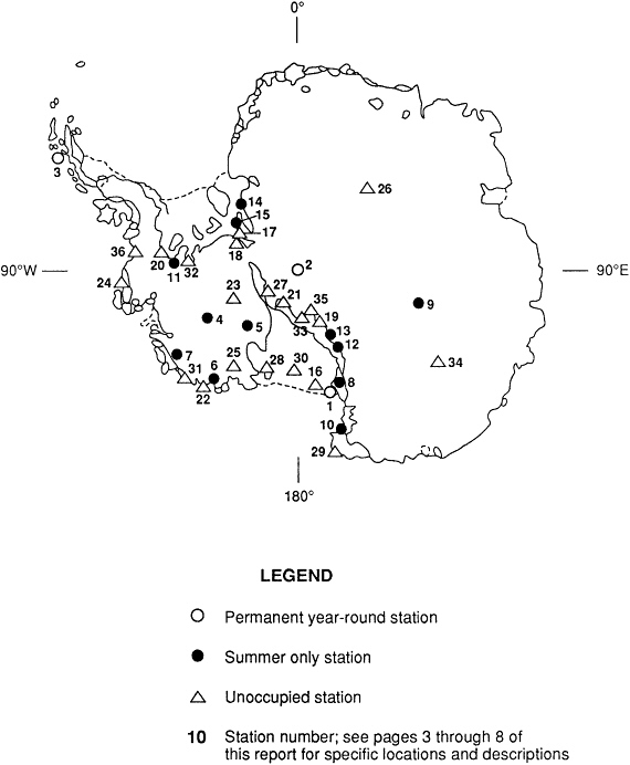
Locations of U.S. Antarctic Research Stations [See Maps A and B]
Permanent Year Round Stations [Map A]
|
1. McMURDO STATION |
|
|
Location: |
Hut Point Peninsula on Ross Island, McMurdo Sound 77°55'S Latitude 166°39'E Longitude |
|
Annual Relief: |
03 October 1989 |
|
2. AMUNDSEN-SCOTT SOUTH POLE STATION |
|
|
Location: |
90°S Latitude |
|
Annual Relief: |
31 October 1989 |
|
3. PALMER STATION |
|
|
Location: |
Anvers Island near Bonaparte Point 64°46'S Latitude 64°05'W Longitude |
|
Annual Relief: |
07 October 1989 |
Summer Only Stations [Map A]
|
4. BYRD SURFACE CAMP |
|
|
Location: |
80°01'S Latitude 119°32'W Longitude |
|
Open: |
02 November 1989 |
|
Close: |
03 February 1990 |
|
5. SIPLE COAST: UPSTREAM BRAVO |
|
|
Location: |
83°29'S Latitude 138°5'W Longitude |
|
Open: |
20 November 1989 |
|
Close: |
26 January 1990 |
|
6. MARIE BYRD LAND: FOSDICK MOUNTAINS |
|
|
Location: |
76°30'S Latitude 144°W Longitude |
|
Open: |
08 December 1989 |
|
Close: |
22 January 1990 |
|
7. MARIE BYRD LAND: EXECUTIVE COMMITTEE RANGE |
|
|
Location: |
76°30'S Latitude 126°W Longitude |
|
Open: |
23 December 1989 |
|
Close: |
25 January 1990 |
|
8. MARBLE POINT CAMP |
|
|
Location: |
77°25'S Latitude 163°40'E Longitude |
|
Open: |
16 October 1989 |
|
Close: |
30 January 1990 |
|
9. VOSTOK STATION (USSR)-(site of a U.S. field camp) |
|
|
Location: |
78°28'S Latitude 106°48'E Longitude |
|
Open: |
02 December 1989 |
|
Close: |
15 January 1990 |
|
10. CAPE WASHINGTON |
|
|
Location: |
740°44'S Latitude 163°45'E Longitude |
|
Open: |
28 October 1989 |
|
Close: |
02 January 1990 |
|
11. ELLSWORTH MOUNTAINS |
|
|
Location: |
78°25'S Latitude 86°30'W Longitude |
|
Open: |
21 November 1989 |
|
Close: |
26 December 1989 |
|
12. TRANSANTARCTIC MOUNTAINS: GEOLOGISTS RANGE |
|
|
Location: |
82°30'S Latitude 155°E Longitude |
|
Open: |
29 November 1989 |
|
Close: |
11 December 1989 |
|
13. TRANSANTARCTIC MOUNTAINS: MILLER RANGE |
|
|
Location: |
83°15'S Latitude 157°E Longitude |
|
Open: |
21 December 1989 |
|
Close: |
03 January 1990 |
|
14. PENSACOLA MOUNTAINS: ARGENTINA RANGE |
|
|
Location: |
82°45'S Latitude 44°W Longitude |
|
Open: |
26 November 1989 |
|
Close: |
11 December 1989 |
|
15. PENSACOLA MOUNTAINS: NEPTUNE RANGE |
|
|
Location: |
83°46'S Latitude 54°W Longitude |
|
Open: |
11 December 1989 |
|
Close: |
03 January 1990 |
Unoccupied Stations [Map A]
Data on unoccupied United States facilities in Antarctica are listed here although such facilities are not considered usable as refuges. Some are so deeply buried in snow as to make them relatively inaccessible, while others are difficult to locate. Information provided: (1) position and description of location; (2) dates established and deactivated or last visited; and (3) estimate of available accommodation, food, fuel, and supplies of other kinds.
16. BYRD AURORA SUBSTATION
-
79°26'S, 188°4'W, approximately 40 miles from present Byrd Station
-
March 1963 -October 1963
-
Prefabricated shelter, 16 man/months food and supplies, 2,500 gallons diesel fuel
17. CAMP NEPTUNE
-
83°31'S, 57°15'W, Neptune Range of Pensacola Mountains
-
November 1963 -January 1966
-
16' × 24' Jamesway building, 32 drums fuel, 4-6 man/months food, 250 lbs. explosives
18. PATUXENT CAMP
-
84°54'S, 63°W, Patuxent Range of Pensacola Mountains
-
November 1962 -December 1965
-
16' × 16' Jamesway building, 4 drums fuel, 458 man/days food plus cooking utensils
19. PREBBLE GLACIER CAMP
-
84°15'S, 164°10'E, at mouth of Prebble Glacier, Queen Alexandra Range
-
November 1966 -February 1967
-
16' × 16' Jamesway building, 4 drums fuel, 1 man/month food supplies
20. CAMP GOULD
-
78°57'S, 85°45'W, East Heritage Range
-
November 1962 -February 1967
-
16' × 16' Jamesway building, 48 drums fuel, 8-10 man/months food
21. AMUNDSEN GLACIER CAMP
-
86°18'S, 160°55'W, adjacent to Amundsen Glacier on the Faulkner Escarpment
-
November 1963 -January 1964
-
16' × 16' Jamesway building, 4 fuel drums, 400 man/days food, cooking utensils
22. BYRD COAST CAMP
-
76°55'S, 144°W, in Edsel Ford Range at Mount Farley
-
October 1966 -January 1967
-
16' × 16' Jamesway building, 2 man/months food and fuel
23. CAMP OHIO
-
84°52'S, 114°20'W, Ohio Range, Horlick Mountains
-
November 1961 -January 1967
-
16' × 16' Jamesway building, 7 drums fuel, cooking utensils, 2 man/weeks food supplies
24. CAMP MINNESOTA
-
73°30'S, 94°30'W, in northwestern side of Jones Mountain
-
November 1961 -January 1965
-
16' × 16' Jamesway building, unknown quantity of food and fuel
25. LITTLE ROCKFORD
-
79°30'S, 147°19'W, (relocated in 1959 from 79°35'S, 156°46'W)
-
December 1958 -February 1965
-
3 Wannigans, 1 improvised shelter, food and fuel unknown
26. PLATEAU STATION
-
79°15'S, 40°30'E
-
December 1965 -January 1969
-
Main building 70' × 25' van; emergency station separated from main building consists of 30' × 8' van attached to 16' × 26' Jamesway; 3-16' × 28' and 1-16' × 16' Jamesway huts with limited supply of DFA and mogas available; however, access may be difficult owing to snow cover; 100 man/months of food plus cooking utensils
27. CAMP OHIO H
-
86°S, 127°W, near crashed R4D aircraft
-
November 1962 -January 1965
-
16' × 24' Jamesway, 4 drums fuel, 2 man/months food plus cooking utensils
28. ROOSEVELT ISLAND HUT
-
80°11'S, 161°39'W
-
1969
-
Provisions for 25; no radio
29. HALLETT STATION
-
72°19'S, 170°13'E
-
January 1957 -February 1973
-
18 buildings (including Jamesway), 58,000 gallons fuel
30. BROCKTON STATION
-
80°01'S, 178°02'W
-
October 1965 -February 1972
-
4 buildings, 14 drums fuel, and 1,100 gallons bulk fuel
31. MARIE BYRD LAND CAMP
-
75°45'S, 135°W
-
October-December 1977
-
5 Jamesway huts, bulk DFA, food
32. ELLSWORTH MOUNTAINS CAMP
-
79°07'S, 85°39'W
-
November 1979 -January 1980
-
1 Jamesway hut
33. McGREGOR GLACIER HUT
-
85°08'S, 170°50'E
-
1982-83 season
-
Full provisions for 7; no radio
34. DOME C CAMP
-
74°39'S, 124°10'E
-
Camp active summer seasons through 1981/82; last visited January 1984
-
8 Jamesway huts, 1,000 gallon POL, 6,000 lbs. food
35. BEARDMORE SOUTH CAMP
-
85°2'S, 164°15'E
-
October 1984 -February 1986
-
1 wooden module, DFA, mogas, JP4 available, 2 man/months food plus stove and fuel
36. SIPLE STATION
-
75°56'S, 84°15'W
-
January 1979 -February 1988
-
An unsafe under-the-snow enclosed area, and Jamesway huts on the surface
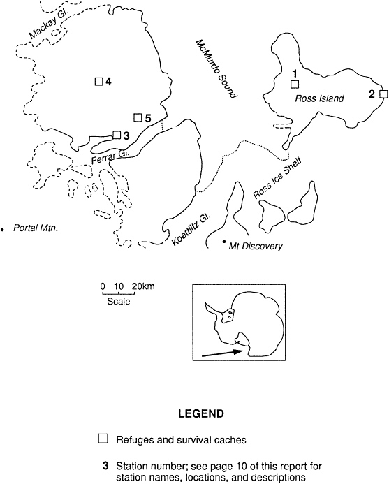
Mcmurdo Area Refuges and Survival Caches [Map B]
Information provided: (1) position and description of location; (2) accommodation, food, fuel, and supplies of other kinds. ''Full provisions'' indicates sleeping, eating, and cooking utensils.
1. MT. EREBUS HUT AND CACHE
-
77°30'S, 167°10'E
-
Hut: partial provisions for 3 (no sleeping bags), oxygen, radio during summer
Cache: full provisions for 6, located 150' from hut
2. CAPE CROZIER
-
77°30'S, 169°40'E
-
Hut: partial provisions for 4; no radio; hut located at approximately 1000' elevation, south of "the Knob" and south of the ice edge
Cache: full provisions for 6, located 100' uphill from hut
3. LAKE BONNEY CACHE
-
77°43'S, 152°25'E
-
Hut: full provisions for 6, 30 man/days food; no radio
Cache: located on southeastern shore of Lake Bonney, approximately 100' from lake
4. LAKE VIDA CACHE
-
77°20'S, 162°E
-
Hut: full provisions for 6, 30 man/days food; no radio
Cache: located approximately 600' from lake on southwestern shore
5. LAKE HOARE HUT
-
77°38'S, 162°57'E
-
Hut: partial provisions for 4 (no sleeping bags); full food provisions in hut; no radio; hut located approximately 100' from Lake Hoare, near base of the Asgard Mountain Range
Cache: no survival cache box established


