
13
Water Resources Forecasting
John C. Schaake, Jr.
National Weather Service
Silver Spring, Maryland
Thomas Carlyle, Scots essayist and historian, called economics the "dismal science." A problem with economics is that ultimately all accounts must balance—there's no free lunch. This rule holds in physics, too. Perhaps if Carlyle had known the second law of thermodynamics he may have had a more depressing view of that science. Balancing accounts of all kinds—economic, environmental, social, physical and international—seems to become more challenging each year. Prices, both economic and environmental, seem to be rising. Capital is hard to find. Interest rates seem high and unsteady. The federal budget has not been balanced for more than a decade. The trade deficit continues to grow, as does the number of homeless. In the three decades since Rachel Carson wrote Silent Spring, the nation has learned to expect environmental consequences of our activities. To see that this awareness has led to an improved environment, one only has to travel to other parts of the world (developed and developing) where the environment has not been valued so highly. But environmental quality is not free; awareness of environmental value limits choices and raises costs.
Within the context of this complex social and environmental background, the nation manages its water resources. The twentieth century has been a time of water development—both physical (as evidenced by the building of reservoirs, levees, and irrigation projects) and institutional (as evidenced by a proliferation of legislation and agencies to regulate water). Hundreds of billions of dollars were invested by government at all levels. Now, the best reservoir sites are taken, the best irrigation projects developed. New stresses on water resources and the environment continue to come from the nation's growing population and economy. Unfore-
seen environmental consequences of existing water projects require attention. And in the international arena, water (both its quantity and quality) may become far more important than oil in the next century as a source of conflict and, potentially, war.
Water must also be managed in a climatic as well as a social context. Water resources decisions are made under the assumption that the climate of the recent past is representative of the future. The possibility of global change suggests that this assumption may be invalid and adds uncertainty to the water management agenda. While climate change may impact water resources significantly, it is interesting that a major source of uncertainty in climate change also involves water. Water is important in the energy balance of the earth: as an agent for energy transport and as a factor in the optical properties of clouds and the atmosphere. A major goal of the World Climate Research Program (a joint program of the World Meteorological Organization and the International Council of Scientific Unions) is to improve understanding of the climate system through a Global Energy and Water Cycle Experiment (GEWEX). Much of the work that must be done by GEWEX to improve our understanding of the hydrologic cycle of the earth is also needed to improve water resources management. Conversely, much of the work needed to improve water resources management should help (in part through GEWEX) reduce uncertainty about climate change and the effects of climate change on water resources. This is a very important issue that will be developed below.
Water management has two parts: one long range, involving the planning, design, and construction of new facilities; the other short range, involving the operation of existing facilities. Both long-range and short-range decisions are sensitive to the hydrological effects of climate variability and change. Water management decisions depend on water resources forecasts, and these forecasts must take into account the effects of climate variability and change.
The drought of 1988 focused national attention on the role of water resources in our country. Print and electronic media brought clear images of the consequences of drought: barges stranded on sandbars in the Mississippi River, empty reservoirs, and withered corn fields. The drought dramatically illustrated that industries tied to the availability of water are inherently risky. Risky decisions in water-based industries are a daily fact of life: barge companies decide how heavily loaded each barge should be; electric and water utilities decide how much effluent can be safely dis-
charged into an estuary; dam managers determine hydropower and irrigation release schedules and operate reservoirs to balance flood control against water supply. In many cases these water management decisions are based on ad-hoc information systems that force inefficient and wasteful utilization of the nation's water resources.
Water resources forecasts for short-range operational decisions are important for several reasons. First, the incremental benefits to the nation of improving the operation of existing water facilities may be at least as great as the present value of all future water facilities; one way to achieve some of these benefits is through improved decisionmaking using water resources forecasts. Second, water resources forecasts must consider climate variability and the current state of the climate system, which requires forecasts of or assumptions about the short-term local climate regimen. The procedures used to translate the current climate regimen into a runoff regimen can also be used to understand the vulnerability of water resource systems to climate variability or change. Third, the hydrologic methods required for water resources forecasting can contribute to improved understanding of the global climate system. This will require research into how we can apply hydrologic models to the many parts of the world for which data are inadequate to calibrate conventional models. Research is also needed to improve models for the significant fraction of the United States that lies between gaging stations and for which available data are inadequate to support model calibration.
SCIENTIFIC BASIS FOR WATER RESOURCES FORECASTING
The science of real-time hydrologic forecasting has reached the point where significant advances can be made to provide improved information for water managers. A water resources forecast may range from the estimation of the stage or discharge of a river for the next one or two days to the prediction weeks or months into the future of quantities such as volume, maximum flow, minimum flow, and time until an event occurs. As the duration of the forecast period increases, the level of uncertainty in the forecast also increases. Information about uncertainty is an important part of a water resources forecast. Thus, water resources forecasts are probabilistic statements about the future. They are particularly useful in decisionmaking when uncertainty is considered explicitly.
Hydrologic Forecast Models
A wide range of hydrologic forecast models have been developed, and many of these could be used as part of a forecast system. On one hand, these models are good enough to produce useful results; a few have been included in the National Weather Service River Forecast System (NWSRFS) that will be described next. But there are important limitations of these models that require improvement, as explained below under Scientific Opportunities.
The NWSRFS is a software system (containing more than 350, 000 lines of computer code) consisting of many programs that are used to perform all of the steps necessary to generate streamflow forecasts. The main components of the NWSRFS (Figure 13.1) are the Calibration System (CS), the Operational Forecast System (OFS), and the Extended Streamflow Prediction System (ESP). The NWSRFS is a modular system that allows the hydrologist to select from a variety of models and to configure them in a way that is appropriate to the application. The models simulate snow accumulation and ablation, calculate runoff, time distribute runoff from the basin to the basin outlet, and channel route streamflow. All of the models are available to the CS, OFS, and ESP systems.
The Calibration System performs tasks needed to process historical hydrometeorological data and to estimate model parameters for a specific basin. In model calibration, simulated streamflow is statistically and visually compared to the observed streamflow. Model parameters are adjusted until the model simulated streamflow best matches the observed streamflow. Brazil and Hudlow (1980) discuss calibration procedures in more detail.
The Operational Forecast System is used to process real-time hydrometeorological data and to make forecasts. The OFS contains three main components: data entry, preprocessor, and forecast. The data entry component is a set of programs that transfer hydrometeorological data from a variety of sources to the observed data base. The Preprocessor component reads raw station data, estimates missing data as required, and then uses these data to calculate mean areal time series of precipitation, temperature, and potential evapotranspiration for a particular basin. These processed time series are stored in a data base for the forecast component.
Forecast component operation is directed by a forecast parameter data base that includes model parameter values as well as information that describes both the basin connectivity of the river system and the sequence of models to operate for a given subbasin.
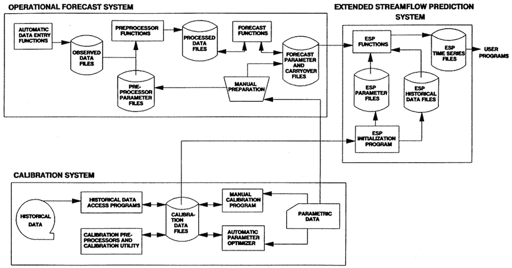
The initial state of the river system at the beginning of the forecast run is held in a carryover data base. Carryover data are usually updated daily based on observed data. This is done to limit how far into the past the OFS must go to make a forecast and to assure that the model initial conditions produce model simulations that are reasonably consistent with current observations.
Extended Streamflow Prediction
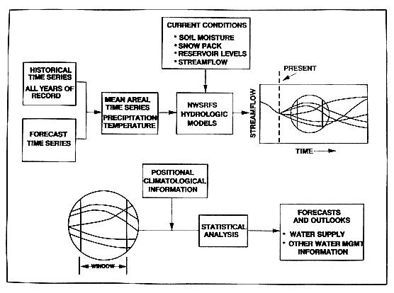
ESP is the portion of NWSRFS that permits hydrologists to make probabilistic forecasts of streamflow and other hydrologic variables (such as soil moisture) for extended future periods (Day, 1985). A schematic of ESP is shown in Figure 13.2. ESP assumes that historical meteorological data are representative of possible future conditions; it uses historical data as input to hydrologic models, obtaining the current states of these models from the forecast component of the OFS. A separate streamflow time series is simulated for each year of historical data using the current conditions as the starting point for each simulation. The streamflow time series can be analyzed for peak flows, minimum flows, flow volumes, and so forth, for any period in the future. A statistical analysis is performed using the values obtained from each year's simulation to produce a probabilistic forecast for a particular streamflow variable. This analysis can be repeated for different forecast periods and different streamflow variables. Short-term quantitative forecasts of precipitation and temperature can be blended with the historical time series to take advantage of any skill in short-term meteorological forecasting. In addition, knowledge of the current climatology can be used to weight the years of simulated streamflow based on the similarity between the climatological conditions of each historical year and the current year.
WATER RESOURCES FORECASTING SERVICES
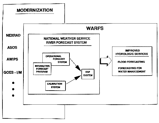
The National Weather Service (NWS) has begun a program for improving its Water Resources Forecasting Services (WARFS). The NWS provides weather and river warning services that have some utility for water management planning and operations; however, the NWS's existing services are structured primarily for flood warning and have limited ability to provide longer-term water supply forecasts. WARFS is a natural extension of the NWS's existing services, because flood forecasting and forecasting for water management interests are based on the same science and technology.
The NWS WARFS program (Figure 13.3) is built on the following components:
-
Existing National Oceanic and Atmospheric Administration (NOAA) river flood warning programs, weather and climate forecasting services, and private sector value-added service links, with the existing NWSRFS as the heart of WARFS;
-
NOAA's NWS modernization program;
-
Other NOAA scientific support capabilities; and
-
Data about river, snow, and precipitation conditions that cost local, state, regional, and other federal agencies more than $60 million annually but that are provided to NOAA essentially free or in return for other NOAA services.
Existing Services
The existing NWS river and flood forecast system produces forecasts of river levels or discharges at more than three thousand locations. Some of these forecasts are produced daily, others only when there is a risk of flooding.
In the western United States, the NWS cooperates with the Soil Conservation Service of the Department of Agriculture to provide seasonal volume forecasts during the snowmelt season. These are issued monthly and are based on regression relationships between the water content of snow measurements and future runoff volumes.
Nws Modernization
Three major NOAA technological improvement programs are underway as part of a strategy to modernize and restructure the National Weather Service. Two of these programs, the Next Generation Weather Radar (NEXRAD) and the Automated Surface Observing System (ASOS) will provide much (but not all) of the technology needed to observe precipitation nationwide. Achieving the required accuracy of precipitation estimates, however, will require data management, integration, and analysis procedures that incorporate a large variety of precipitation data sources from other federal, state, and local gage networks. The third component of the NWS modernization program is the Advanced Weather Interactive Processing System (AWIPS). The function of AWIPS is to provide a modern interactive processing environment that will be the center of all forecast operations in a particular office. Data analysis and quality
control, forecast modeling, forecast interpretation, and product formulation will be carried out interactively at modern workstations. The data and computer programs provided by the NWS modernization programs, along with the technology of advanced hydrologic and climate forecast models will be used to:
-
support forecast service requirements of government and quasi-government water managers;
-
provide basic water resources forecasts to private sector intermediaries who will tailor forecasts to serve specific industries;
-
satisfy the needs for forecast services at a variety of time scales and for a variety of water use situations nationwide;
-
provide critical information on hydrometeorological forecast reliability that can be used for risk-based water management decisionmaking;
-
incorporate improved weather and climate forecast information into hydrological models; and,
-
improve other forecast capabilities.
Example Applications of Warfs Technology
In a few locations, the NWS has already implemented ESP procedures, and these are being used to make water resources management decisions on a limited basis. In 1977, the NWS began developing water resources forecasting technology for the Potomac River basin. This activity came in response to requests for assistance in alleviating an impending water supply crisis in the Washington, D.C., metropolitan area. During drought periods, water demands from a growing population exceeded the capacity of existing water facilities, which relied on the unregulated Potomac River and two small regulated streams in adjacent basins. Proposals to solve the water supply crisis for the politically divided region had emphasized construction projects (such as building as many as 16 major dams and reservoirs) with high costs and little public support. By the early 1980s, it was clear that local water managers were sold on the soundness of WARFS technology and its cost-effectiveness. In 1983, a series of contracts were signed by the federal government, the state of Maryland, and the Commonwealth of Virginia. These contracts provided for a limited construction program of two reservoirs and joint operation of the water resources of the region using prototype WARFS technology. The project was nominated for the Outstanding Civil Engineering Achievement Award of 1983.
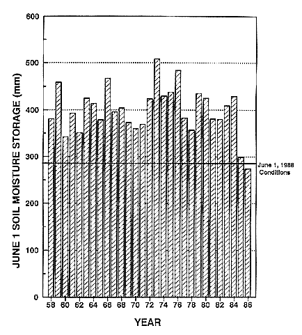
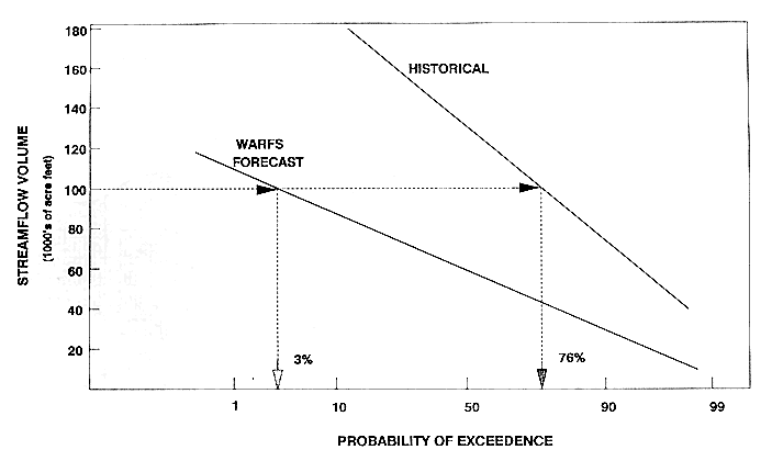
More recently, the Southeast has experienced extended drought conditions. Beginning in 1986, ESP forecasts were generated for the Lake Lanier basin on the Chatahoochee River. Lake Lanier is the primary water supply source for the Atlanta, Georgia, metropolitan area. By 1988, soil moisture conditions were extremely dry. Figure 13.4 compares soil moisture conditions on June 1, 1988 with those on June 1 for the years 1958 through 1986. These values were generated using the NWSRFS. ESP was used to produce probabilistic streamflow forecast information, such as that shown in Figure 13.5. This plot shows the reservoir volume for June 1988 as a function of probability. The line labeled ''historical'' is based on an analysis of the historical streamflow for June. The line labeled "WARFS forecast" is based on ESP analysis that takes into account the extremely dry soil moisture conditions that existed on June 1, 1988. The historical streamflow analysis indicates that the probability of an inflow volume of 100,000 acre-feet or larger is 76 percent (for any year taken randomly), while the ESP analysis indicates that the corresponding probability is only 3 percent for 1988. This difference is particularly large because of the extreme drought conditions of 1988. It illustrates the potential importance of state of the art forecast information to water supply operations.
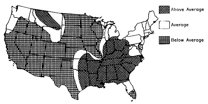
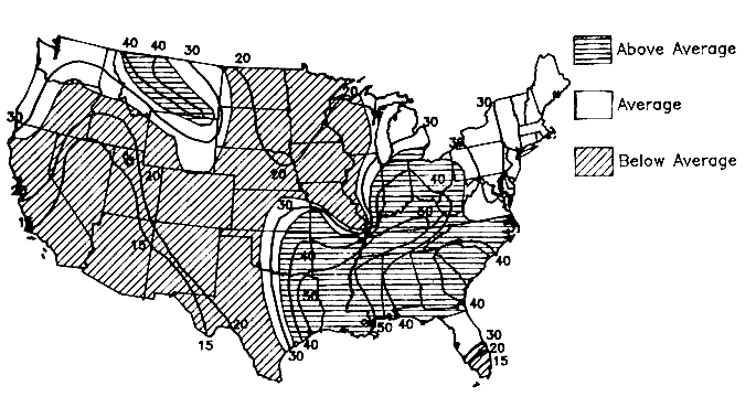
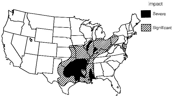
It is possible to generate many additional forecast products for water resources using WARFS technology. Figure 13.6 shows spring flood potential conditions across the nation that the NWS estimated for 1990. This map is based on the qualitative judgment of hydrologists using information from a variety of sources (including models, the Palmer Drought Index, and observed precipitation). Figure 13.7 shows the type of information that could have been made available with WARFS technology. Using ESP, it would be possible to estimate quantitatively the probabilities of flooding. This type of product would provide the forecast information needed to make complex water management decisions using a risk-based analysis. Although the example is based on probabilities of flooding, the same type of information could have been generated for droughts. Evidence that valid information is present in such long-range forecasts is suggested in Figure 13.8, which shows flood conditions as of May 1990.
SCIENTIFIC OPPORTUNITIES
Although water resources forecasting methods are well enough advanced to produce useful results for water management, they have important limitations and deficiencies that need to be corrected. Some of these are discussed below.
Models and Parameter Estimation
Existing hydrologic models do not have a very strong physical/mathematical basis for their structure. The models' parameters depend on the physical characteristics of basins and on the climate. The lack of physical/mathematical foundations for the models means that their parameter values cannot be estimated on the basis of physical properties or climate information.
Currently used model calibration procedures do not adequately consider the potential biases in precipitation and runoff measurements or potential evaporation estimates. In any large river system, model calibration is possible only over a small part of the total area—the headwater area where streamflow is unregulated and represents the natural runoff. Parameters estimated for these areas are then assumed to apply to other areas. If model parameters could be related to physical characteristics and climate, multiple basins could be calibrated simultaneously, and the effects of local measurement biases might be reduced.
Gewex Continental-Scale International Project
Because water is an important factor in the redistribution of energy from the equator toward the poles and in the optical properties of the atmosphere that control the local energy balance, it is necessary to understand better the hydrologic cycle to improve the estimates of how increasing greenhouse gas levels will affect the climate. Accordingly, a major international project is being planned to acquire data (both historical and new) and to conduct research on the water and energy balance of the land and atmosphere over a large continental area. The area selected is the Mississippi River basin and as much of the rest of North America as it may be feasible or necessary to include in the study. Certain process studies may occur in other parts of the world as well.
There are some important relationships between the GEWEX Continental-Scale International Project (GCIP) and WARFS that need to be developed. For example, one of the specific goals of GCIP will be to account for the water balance of ungaged river basins. This is necessary to improve the way atmospheric models represent hydrologic processes globally. In most parts of the world there are insufficient data to calibrate the parameters of hydrologic models. The studies that GCIP will carry out would be useful to WARFS and may produce a new generation of hydrologic models and parameter
estimation techniques that would be easier to use than the present ones. On the other hand, many of the studies and data preparation steps that will be important to GCIP will be needed by water management and forecast agencies. Therefore, GCIP must rely on these activities for partial support.
Long-Range Weather Forecasting Improvements
Although there may be better ways to use existing long-range weather forecast information for hydrologic forecasting, there may be still better ways to develop new long-range weather forecasts specifically for use by WARFS. Recent analysis of the El Niño and its relation to the climate system suggest that new climate forecast products could be developed. In the next few years, these are likely to be mostly statistically based forecasts. In the long run, general circulation models of the global atmosphere and oceans may add new information to the statistical analysis. Because there will always remain substantial uncertainty in long-range forecasts, careful attention must be given to both the statistical and the physical bases for such forecasts.
Orographic Precipitation Analysis and Precipitation Forecasting
In the western United States, most water comes from winter precipitation. This precipitation is spatially highly variable because of the mountains. Using relatively simple water and energy balance models of the atmosphere, the orographic component of precipitation can be estimated. The output from orographic precipitation models can be combined with limited surface measurements of precipitation at low elevations and with snow water content at higher elevations to make improved estimates of the spatial distribution of precipitation and snow water content. The procedures for doing this are analogous to the procedures that will be used in AWIPS to merge NEXRAD precipitation estimates with rain gage data to make optimal combined rainfall estimates.
The same orographic precipitation models useful for analyzing precipitation that has already occurred can potentially be used in conjunction with regional meteorological forecast models to make quantitative precipitation forecasts. Also, it may be possible to use observations of precipitation from the atmosphere to update the
moisture content variables of atmospheric forecast models. The method for doing this would be analogous to the methods used in hydrologic forecasting to update soil moisture variables using observed streamflow data.
Data Base Improvements
Improvements are needed in both historical and operational data systems to make hydrologic analyses more efficient and more accurate. Historical data bases for all of the hydrometeorological information needed for WARFS are not economically accessible, and some critical information is available only in printed publications (such as historical observation times of daily precipitation data, which change from time to time at many stations). Fortunately, these same data are needed for the GCIP, and there is a NOAA initiative to improve access to NOAA's environmental data.
Operational data systems are being improved by many different agencies. The Geostationary Operational Environmental Satellite (GOES) data collection system is being used to improve real-time availability of data. Nevertheless, the random reporting capacity of existing data collection platforms and of the GOES satellite are not being used efficiently. This results in time delays of many hours before data are received by forecasters and water managers. This means that ground truth data that are vital to the NEXRAD precipitation estimation algorithms may not be available when they are needed most. Also, about 500 more automated precipitation gages are needed nationwide to support NEXRAD precipitation estimation.
Improvements in ESP
Although ESP software allows short-term quantitative forecasts of precipitation and temperature to be used, it has generally not been used in practice. Procedures for using short-term probabilistic precipitation forecasts in ESP are still being developed. These procedures must account for the temporal and spatial covariance of future precipitation patterns, as well as for the general magnitude or intensity of precipitation. In addition to designing procedures to incorporate short-term forecasts in ESP, guidelines for deciding historical weights of various years need to be developed. The procedure of assigning weights to historical year simulations has been used only in experimental applications of ESP.
One of the implications of climate change for ESP is that climate events far into the past may not be representative of the present. Therefore, the number of historical years of data that should be used in ESP simulations is limited, perhaps to only 20 or 30, depending on how fast climate changes. Also, it is essential to keep existing hydrometeorological data systems operating, even if there already is an extensive historical record. Continuing to operate existing data systems is necessary so that recent data may be used in ESP and so that model parameters (which are also a function of climate) may be updated. Yet, because of the current federal budget pressures, proposals to reduce data networks are being made to meet budget targets.
An alternative to using historical hydrometeorological data to drive ESP is to use stochastically generated data. This involves making assumptions about the hydrometeorological processes that are not necessary if historical data are used. On the other hand, if climate is changing and if data networks are reduced, the stochastic alternative may be needed. One advantage of the stochastic approach is that forecasters would have more control over the current climatic regimen and could consider not only the effects of long-term change but the current state of the atmosphere, oceans, and continents.
ACKNOWLEDGMENT
Most of the figures and examples and many of the ideas expressed in this paper are based on the work of Gerald N. Day, who is responsible for technical oversight of NWS ESP procedures and who is serving as the program manager for the NWS WARFS initiative. I gratefully acknowledge his contribution and advice.
REFERENCES
Brazil, L. E., and M. D. Hudlow. 1980. Calibration procedures used with the National Weather Service River Forecast System. Pp. 371-380 in Preprint Volume, IFAC Symposium on Water and Related Land Resources Systems, Case Institute of Technology, Case Western Reserve University, Cleveland, Ohio, May 28-31.
Day, G. N. 1985. Extended streamflow prediction using NWSRFS. American Society of Civil Engineers, Journal of Water Resources Planning and Management 111(2):157-170.


