
19
Managing Water Supply Variability: The Salt River Project
John Keane
Sur face Water Resources
Phoenix, Arizona
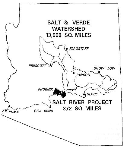
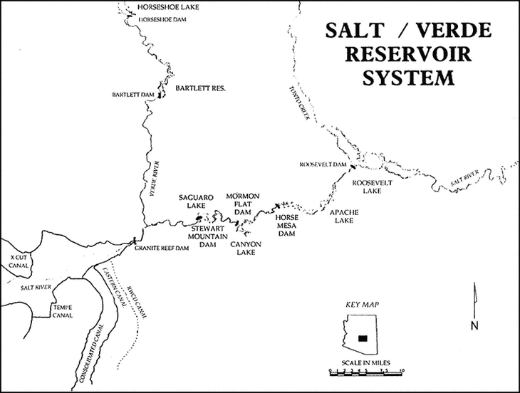
In a state generally cursed with a lack of surface water supplies, the Salt and Verde river watersheds play a pivotal role. These rivers provide much of the water supply for the greater Phoenix area. Their watersheds stretch in a dividing band across the state (Figure 19.1). To the north lies the drier, relatively flat Colorado Plateau. To the south and west lies the Sonoran Desert, much of which is a series of very broad alluvial valleys separated by metamorphic mountain ranges. The Salt and the Verde watersheds have played an enormously important role in defining Arizona and shaping its growth. These highlands are an orographic barrier to winter storms from the Pacific, forcing cool, moist air to rise and to leave a substantial amount of moisture behind. The highlands also serve as the point of origin for many of the summer thunderstorms that develop in July, August, and September, when moisture flows up from Baja, California and the Gulf of Mexico. The slightly cooler and wetter conditions of the highlands are responsible for much of Arizona's forest land, streamflow, and riparian habitat and provide a place to escape the summer heat of the desert below.
BACKGROUND
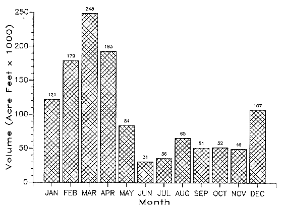
The Salt and Verde watersheds have very dry spring and fall periods, separated by a winter season (lasting from December through mid-March) of occasional storms and a summer of scattered thunderstorms. The summer rains do not provide much of the year's streamflow volume because the rains are absorbed by soils left extremely dry by the endless sunshine and very low
cipitation is the dominant force in determining the volume of annual streamflow (Figure 19.2). Some of the increased river flow during the winter and spring comes from rainfall runoff in the area below about 6,500 feet. An even larger portion comes from late winter and early spring snowmelt from the areas above this elevation. In either case, enough rain or snowmelt must be absorbed by the soil to satisfy the considerable soil moisture deficit built up during late summer, fall, and early winter before river flows begin to increase noticeably. The first several storms of winter disappear into the soil without affecting streams at all.
The Salt River valley has a remarkable combination of traits: flat, well-drained soil, available surface water and a long growing season. These characteristics attracted Native American agriculturalists for hundreds of years before Anglo settlement (Figure 19.3), but the Native Americans abandoned the land along the Salt River long before Anglo settlers arrived (although they were still occupying land along the nearby Gila River). There is evidence that water supply variability in the form of both floods and droughts played a role in the Native American abandonment of the Phoenix area. Nonnative settlers began rejuvenating the old native canals in the late 1860s, and then expanded them and built new ones. Over the next 40 years, the same extreme water supply variability that is the focus of this conference plagued the farmers in the Salt River valley. These farmers, however, showed the determination and the tireless skill as promoters that have been the hallmark of the area up until very recently. They, like so much of the West before and after, promoted a federal solution to this supply variability. They were instrumental in the passage of the Reclamation Act of 1902; they succeeded in having Roosevelt Dam, begun in 1904 and completed in 1912, approved as the Bureau of Reclamation's first big project. Other dams along the Salt and the Verde followed over the years and, unlike many other Bureau of Reclamation projects around the West, these were paid off in full in 1955. There is no outstanding debt on the extensive system of dams and canals.
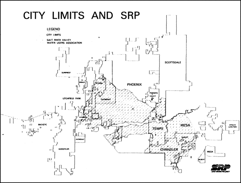
The Salt River Project (SRP) dams store water for the lands within the project boundaries—lands originally judged by a 1910 court decree to have established rights to the Salt and Verde rivers. Over the years, however, growth in the Phoenix area has expanded far beyond the lands having these rights (Figure 19.4). The lands outside the project area could be settled only by using the limited supply of the Agua Fria River in the West Valley or by using deep well pumps to draw water from the enormous alluvial aquifer underneath the valley.
Dams
The SRP water supply system today has four dams along the Salt River and two on the Verde (Figure 19.5). All four dams on the Salt have hydroelectric capabilities while neither dam on the Verde does. The characteristics of the dams important for this discussion are:
-
Storage capacity for the system is not equally distributed between the Salt and Verde rivers. Most of the storage volume (nearly 85 percent) is on the Salt River. Total storage space on the Verde River is approximately equal to the Verde's annual flow, while storage space on the Salt is roughly three times the annual flow.
-
The total storage capacity of the entire system is less than double the average flow of the Salt and the Verde rivers combined. This is also about twice the annual demand placed on the system—a small storage capacity compared to the giant storage reservoirs on the nearby Colorado River.
-
The dams were built solely for water conservation. Thus, this system of dams is not truly a multipurpose reservoir system. The dams provide some incidental flood control benefits and the lakes behind them are heavily used for recreation, but in their origin, design, and legal obligations the dams are single-purpose structures.
Ground Water
Ground water often has been used to supplement surface water deliveries. Ground water provides anywhere from 5 percent (during times of ample surface water supplies) to 35 percent (during periodic droughts) of the million acre-feet per year of water demands on the Salt River Project. (Most of this demand is now urban rather than agricultural.)
SUPPLY VARIABILITY
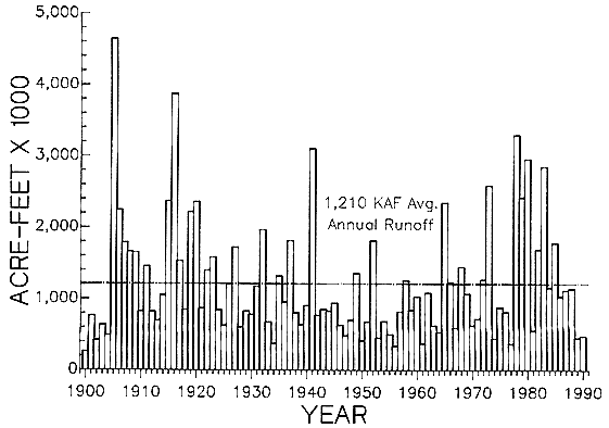
The extraordinary variability of Salt River flows bedeviled. Native American societies and drove farmers to seek federally-funded storage projects. Just how variable were these flows? Just how variable are they now? Tree-ring records show great variability in prehistoric times. The recent historical record gives an indication of what drove farmers to seek regulation of the Salt River (Figure 19.6).
The historical record begins with three wet years. The Salt and Verde together in 1889 produced 1.7 million acre-feet of water.
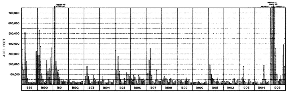
In 1890, 2.6 million acre-feet of water flowed by, and in 1891 the figure rose to more than 3 million acre-feet. In that year, everything crossing the river was washed away; a flood several miles across inundated downtown Phoenix and a great deal of farm land. The next year, 1892, one of the driest years ever recorded was producing river flows of 299 thousand acre-feet. River flows remained well below average for several years thereafter. Several ups and downs of wet and dry years followed, and then a drought began in 1898 that lasted for 7 years. This drought remains the worst on record. Construction of Roosevelt Dam began in late 1904 and, as if on cue, in 1905, over 5 million acre-feet flowed down the rivers and washed out the early stages of work on the new dam. It remains the wettest year in the historical sequence.
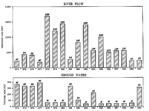
The wild gyrations of weather at the turn of the century are not just a thing of the past; they have continued up to the present time even though their impact has been softened by storage reservoirs and ground water pumping (Figure 19.7). The Salt and the Verde watersheds suffered through the same dry conditions from 1974 through 1977 that were common throughout the western United States. The late 1970s and early 1980s then brought one of the wettest periods of central Arizona's history, with enormous flood damage. True to form, we are now back in drought conditions. The years 1989 and 1990 have been extraordinarily dry. Indeed, they represent one of the very driest 2-year periods on record, surpassed only by the drought at the turn of the century.
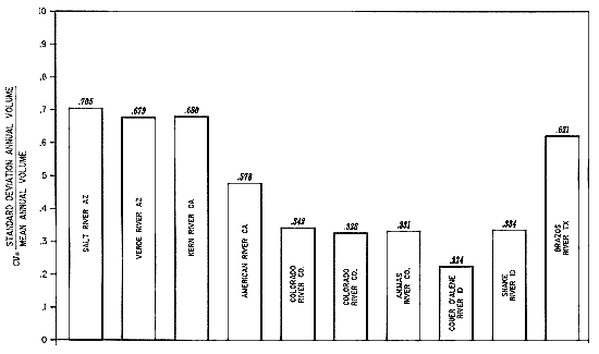
Average annual inflows to the reservoir system are around 1.2 million acre-feet, but this average is skewed by relatively rare, extremely large events. Median inflows are only around 950,000 acre-feet per year. The coefficient of variation for the river flows for the period 1889 through 1989 is very large, even when compared to other rivers in the western United States where variability is expected to be large (Figure 19.8). This historical record shows both prolonged wet periods and droughts lasting anywhere from 2 to 7 years; these appearances of dry and wet periods have no apparent pattern or sequence that is easily discernible or predictable (Figure 19.9).
Since most of the water in the Salt and Verde rivers originates from winter and spring precipitation, the variability of the winter season is the key to describing water supply variability in Arizona. One influence on Arizona water supply variability is a change in the pattern of Pacific storms that typically begins in late November or early December and continues until mid-March. Several very dry recent years resulted from a premature end to this pattern—a switch to dry, spring weather in early February. A second influence on
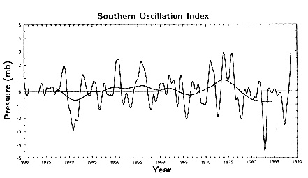
winter water supply variability are physical factors taking place on a gigantic scale. For example, the global effects of major El Niño episodes usually are associated with wet winters. A third influence on water supply variability is the temperature of the winter season. Because of Arizona's southerly latitudes and the relatively modest elevation of its mountainous areas, snowpack formation is very sensitive to winter temperatures. Relatively small temperature changes shift the snowpack up or down in elevation, and this causes drastic changes in the overall size and volume of the snowpack. Temperature also changes the percentage of the watershed that receives rain rather than snow during any winter storm event, which in turn can profoundly impact the total amount and distribution of winter runoff. Many observers have pointed out that a global warming trend could influence the distribution between rain and snow in the western United States, and the Salt and Verde watersheds are more sensitive than most areas. A fourth influence on winter water supply variability is the temporal distribution of winter storms, which affects rainfall runoff. Storms that are well spaced, with long periods of sunny weather in between, produce less runoff than the same amount of winter precipitation crowded into a few weeks of heavy storm activity. Finally, winter water supply variability is influenced by the antecedent soil moisture conditions before the winter storm season begins. Heavy rains in late summer and fall on the Salt and Verde watersheds can turn even average precipitation the following winter into better-than-average runoff. Average winter precipitation can produce poor seasonal runoff if dry conditions prevail during the prior summer and fall.
RESPONSES TO SUPPLY VARIABILITY
The Salt River Project, like most other water providers in the western United States, must meet a relatively constant water demand with a widely fluctuating water supply. Clearly, the SRP must plan for these water supply fluctuations and make changes to its operations.
The traditional western response to periodic excesses in surface water supplies is to reduce expensive ground water pumping and to increase surface water storage. Surface water storage is currently being increased along the Salt River. Roosevelt Dam is being raised, largely for flood control and dam safety considerations, but also to provide several hundred thousand acre-feet of additional conservation space. Increasing reservoir storage, however, is clearly no longer an
easy or cheap solution. (In fact, the SRP did not acquire the additional storage at Roosevelt Dam; it was acquired by valley cities that need the water to supply the lands outside of SRP boundaries.) Additional storage has been suggested on the Verde River between the current Horseshoe and Bartlett reservoirs, and storage has been suggested at the confluence of the Salt and the Verde. Like new dams elsewhere in the West, these proposed structures ran into various environmental and social problems. By the time riparian habitats, bald eagles and Native American tribes were all considered in the decisionmaking process, the opportunities for additional surface water storage were thrown out. Few people expect to see them surface again any time soon. Even without social and environmental problems, such structures are very expensive, and Arizona's state government and the federal government are both wrestling with deficits of depressing proportions.
What other strategies can water managers adopt to make use of periodic high river flows? One often-mentioned possibility is to recharge excess surface water into the valley's alluvial basin. To a very significant extent this happens naturally; releases of excess water out of the lowest dams on the Salt and Verde into the dry river channel through Phoenix result in a good deal of natural recharge. There is limited opportunity for recharge projects to store more of these flood flows underground. However, these flows often come in quantities that are too great to capture and at time intervals that are too sporadic. Also, downstream water rights holders may want to benefit from these flows and therefore might oppose recharge projects.
What happens, on the other hand, during times when surface water supplies are shrinking and are not able to satisfy local demand? The SRP has responded in the same way as others all across southern Arizona have responded: by increasing ground water pumping. Southern and western Arizona host several large alluvial aquifers that have taken millennia to fill with water. In the last 70 years, pumping has significantly reduced some of these supplies. Pumping has long been crucial in the Phoenix area for handling supply variability. As water supplies and reservoir levels drop, pumping is increased. The customer simply pays a little more and otherwise notices little difference in the available water supply during surface water shortages.
Ground water is more costly to produce than Salt and Verde river water, not only because of pumping costs but also because of diminished water quality. Some of the ground water in southwestern alluvial basins was not of optimum quality to begin with, having a high total dissolved solids content. In many areas, man has made
matters worse. Nitrates, insecticides, and industrial solvents exceed recommended levels in several SRP wells, reducing total pumping capacity. This problem is exaggerated because pumping capacity is not equally distributed throughout the system. Some municipal filter plants are getting far more of the poor quality ground water than others during dry periods, and this has effects on the taste and odor of the water and on treatment plant operations.
Water quality concerns and pumping costs aside, there is the longer-term problem of relying upon what in some ways is a finite ground water supply. Natural recharge in the Phoenix area is very small, especially because surface water flows are now captured behind the dams above the valley. Incidental recharge from both urban and agricultural water uses helps to replenish the aquifer to some extent, but at current levels of ground water pumping the aquifer under Phoenix could be largely dewatered in perhaps 200 years. Ten years ago, Arizona passed the Ground Water Management Act in an attempt to begin dealing with this problem. Currently, legislators are addressing the act's shortcomings to determine how to cut back on the use of the relatively cheap and dependable but finite supply that lies under our feet.
What else does the SRP do besides increasing pumping when it is faced with surface water shortages? As reservoir levels fall and as pumping approaches production capacity, the SRP reduces water allocations to its customers. In addition to straightforward supply cutbacks, there are, of course, any number of mechanisms that agricultural agencies and municipal governments can use to promote water conservation. Depending on the program involved, water use reductions may be imposed only temporarily, during drought periods, or they may aim for long-term demand reduction.
In drought periods, such as the one Arizona and California are now facing, reduced supply allocations bring up conservation issues, which frequently spill over into economic and social issues. Urban water users point to agricultural users as being selfish and wasteful and using too large a share of the water. Agriculturalists are frequently defensive and claim they cannot afford the investments in conservation technologies that urban dwellers feel they should be using. Similarly, some cities blame other cities for not trying hard enough to conserve, non-golfers point out how much water golf courses use, and so forth. There is plenty of finger pointing to go around.
Finally, as supplies shrink, interest grows in reusing sewage effluent, which is often touted as the only source of supply that is actually increasing. That water reuse will become a major force in
the water future of the Southwest is clear. Effluent has its problems, however. Environmental and health regulations make it difficult and expensive to treat effluent for reuse or for recharge into aquifers. Some areas seem to be adding golf courses, parks, and artificial lakes just to put this resource to use. In the long run, it will make more sense to use effluent to displace ground water mining rather than to inflate demand to include effluent. That will happen, but it will take time.
So, the surface water supply of the Salt River Project is highly variable. Probably not much can be done to capture more of it during wet periods. Most of that water will continue to be lost in flood releases. Surface water supply shortages are going to occur sporadically under present conditions, and most climate change scenarios either leave this situation unchanged or make it worse. Turning to increased ground water pumping as we have done in the past cannot go on forever. It is not a very renewable resource, water quality is degenerating in many cases, and land subsidence can be a problem. Water conservation and reuse are clearly important and must become more so in the future. Conservation has its practical limits, however. Are there other sources that the Salt River Project could turn to for backup supplies when surface water supplies are low?
SEARCHING FOR BACKUP SUPPLIES
Population growth long ago outstripped renewable water supplies in central Arizona, although the Central Arizona Project (CAP) is trying to remedy this. This is true for the Salt River Project, and it is even more true for other areas in Arizona. Once an area has outstripped its local supplies, it goes looking for a backup either because it wants do deal with growth that has already occurred or because it wants backup supplies to allow further growth. What could the SRP do (as Los Angeles and Denver have done) by rerouting or transferring water to bring in new supplies? Where should we look for new supplies?
One idea that has been suggested time and time again over the last 50 years is simply to increase the flows of the Salt and Verde rivers themselves. Two techniques are usually suggested: watershed management and weather modification.
One form of watershed management is to decrease the water use by vegetation and, therefore, to eventually increase the streamflow. This involves either increased timber harvest, increased timber thin-
ning, or chaparral brush reduction through fire or other means. It has been shown through research studies that runoff can be increased in these ways, although precise quantities of runoff increase are hard to pin down. In order to make a really significant change in river flows, however, there would have to be a concomitantly large change in the way the watersheds are managed. Most of the water-sheds in question (the middle and higher elevations) are U.S. Forest Service land or Native American reservations. In both cases, the lands are managed for a variety of products and a variety of uses. This web of multiple-use management, along with areas set aside for wilderness, sharply limits the kind of vegetation management that is possible. What is more, the public (probably rightly) feels that large-scale vegetation changes would be harmful. Even relatively small changes in land management—changes that may be ecologically sound and based on the ecological history of the Southwest—can be rejected by the public. Any kind of active management by Forest Service officials is often viewed as suspicious and dangerous. The end result is that changing land management in the future by the Forest Service and Native Americans may make subtle changes in river flows, but really significant increases in water supply cannot be expected from this type of activity.
Weather modification has been attempted in the West ever since the late 1940s. There are good scientific reasons why cloud seeding under certain conditions may produce an increase in winter orographic precipitation, and this in turn could increase snowpacks and runoff. These increases, however, are extremely difficult, if not impossible, to prove or quantify. It is difficult to expect governing boards and state legislatures to pay for weather modification programs when the benefit is uncertain and unmeasurable. Then too, the public may be skeptical of any attempt to ''meddle with Mother Nature.'' As with watershed management, there may be opportunities here and there for small increases to river flows, but these will not be large enough or regular enough to be any kind of real solution to water supply variability problems.
For both of these flow augmentation techniques there is another problem. Increased flows from both weather modification and watershed management tend to come in the wetter years, when rivers and reservoir water levels are already high. Several simulation studies in Arizona have shown that a good portion of the increased water yield, from either watershed management or weather modification, would be spilled from already full reservoirs into the dry Salt River bed. In order to use the augmented flows of the Salt and Verde rivers, you would have to increase reservoir storage, and as I discussed earlier this is not easy to do.
If backup water supplies are not going to come from augmented flows of the Salt and Verde rivers, can the SRP turn to the Colorado River, that source that has been lusted after and tapped by all kinds of other thirsty water users? Southern California and Denver have been tapping the Colorado River in transbasin diversions for years. Las Vegas is attempting to use more Colorado River water. And of course the Central Arizona Project is now bringing substantial quantities of Colorado River water to supply parts of the valley not supplied by the SRP. Can the SRP tap into this source also? The SRP was offered a modest allocation of CAP agricultural water (30 thousand acre-feet) but turned it down. There were several reasons for this, and these reasons still pertain today. First, the use of this water would have subjected SRP agricultural water users to the Reclamation Reform Act, and no one undertakes that sort of burden lightly. Second, other water users in the state had no access to local surface water supplies like those of the Salt and Verde rivers. This is especially true of the cities in the valley that needed supplies for their non-SRP areas. For the SRP (already viewed as water rich) to try to corral a substantial share of Colorado River water would have been politically unpopular to say the least. Today the cities, developers, irrigation districts, and Native American tribes are all vying for the remaining unallocated shares of the Colorado River. The competition is intense and will become more so. Really large participation in the CAP by the SRP is not feasible at this point. The CAP may in the future bring some small relief to supply variability problems. Some cities are already beginning to use CAP water on SRP lands under certain circumstances. The future will no doubt bring various kinds of long-term or short-term exchanges between the two systems to help deal with droughts or system outages due to mechanical problems, but such exchanges will not provide a major new supply for the SRP.
Where else might the SRP go for backup water supplies? Water transfers from rural Arizona are one possibility. Non-CAP Colorado River water now being used for agriculture might be brought in through the CAP canal during times when excess canal capacity is available. Or, ground water from several basins in Arizona could be pumped and brought (perhaps through the CAP canal) to the Phoenix area. Water transfers have been a hot topic in recent years throughout the West and in Arizona. Several cities have bought water farms in western Arizona and in Pinal County, south of Phoenix, as backup supplies for the future. These water farms are a relatively expensive proposition, and if the CAP canal does not have excess capacity for transporting the water, an additional separate conveyance system
would have to be built for some of these sources. The price would then become astronomical. (In 1991 the Arizona legislature banned ground water transfers from most rural areas, with some limited exceptions. The race for rural ground water supplies has stopped for now.) There could be both long-and short-term water leasing, as well. Leasing of agricultural water during dry periods holds some promise as a backup source for the thirsty urban areas. It is far from clear, however, whether the SRP will be involved in these kinds of transfers any time soon.
The water transfer issue, once raised, very quickly becomes a highly emotional one in which rural people are pitted against city dwellers. Rural people, even in areas that have little water that anyone wants, have organized to oppose potential water raids by the city dwellers. There are sometimes shrill and sometimes outrageously overdrawn depictions of urban octopi with their tentacles grabbing up the water supplies from the rural areas in order to suck them dry. These depictions raise important issues. Should Phoenix, Tucson, Los Angeles, and San Diego all continue to grow even though they far outstrip their supplies of water and clean air? Does it make sense to sacrifice the future of certain rural areas, however small and however bleak their future prospects may be, just to squeeze a few more people into already intolerably crowded cities? To the dismay of the city water planners, even many city citizens are beginning to sympathize with the rural point of view and find the notion of sacrificing rural futures for urban demands to be unacceptable. Water transfers are an old story in the West; they are an old story in Arizona. Some will continue, and some new ones will be undertaken. This is clearly not, however, a simple solution to the Salt River Project's supply variability problem.
CONCLUSIONS
Though future climate change patterns are anything but certain, some of the most likely scenarios now being painted suggest that the already extreme surface water supply variability in the Salt and Verde river watersheds may increase in the future. In the past, the supply variability problem in the Salt River basin has been met by pumping ground water. The ground water supply is still large; ground water will continue to be the Salt River Project's main backup in dealing with surface water variability for a long time to come. Problems with this ground water resource are beginning to surface, however. Water quality problems are multiplying, water levels in
many parts of the SRP have declined significantly, and it is gradually becoming clearer that the ground water supply, which is renewed very slowly, cannot be mined indefinitely just because it is the cheapest alternative at hand. Dealing with the ground water over-draft is a little like dealing with our federal budget deficit: it is relatively cheap and painless in the short run just to let the deficit ride or even grow, but this course passes the burden to future generations. Slowly but surely, even in the conservative Phoenix basin, where government intervention is despised as much as any place else in the country, the necessity of government control of ground water mining is slowly becoming accepted. As taxes are levied to decrease consumption, ground water will become more and more expensive to pump.
Yet, the situation is not at a crisis point in the Phoenix area—at least not yet. There is ample room for conservation to expand supplies. Conservation by both agricultural and urban users is really just beginning. Reuse of sewage effluent will become much more important and will provide the valley with additional water for either future growth or for reducing the ground water overdraft. There is still a great deal of water use by agriculture, and this water will gradually, whether in an orderly or a disorderly fashion, be shifted to urban uses. So water will be argued over, traded, swapped and recirculated, but there will not be shortages severe enough to curtail urban growth for some time to come—several decades at least. Supply variability will be met by varying ground water pumping, by increasing conservation and effluent reuse, and by some water transfers.
The time will come in the next century when these various sources of water will no longer be sufficient to sustain Sun Belt growth rates. Planners might want this to occur relatively quickly. They might want to shift growth to other parts of the state or country where air quality is better, water is more plentiful, and the environment is less fragile. Given the history of the West and of the United States in general, however, it is highly unlikely that political restrictions on urban growth will ever be successful. Somewhere in the future, market-like mechanisms will begin to take hold. Either water will become very expensive or the quality of life will become so degraded (or both) that growth in areas like Phoenix and Tucson will slowly grind to a halt. By that time, we will have much larger urban populations, much less agriculture, and many more people expecting a steady supply of water. This, in turn, will make it more difficult to deal with increased supply variability that the greenhouse effect may bring about.


