
1
The Grazinglands of Northern China: Ecology, Society, and Land Use
In 1989 the total area of China was 960 million hectares (9.6 million km2), of which an estimated 400 million hectares, or 41.7%, were classified as grassland. More than half of these grasslands are in northern China, the area covered in this study. These northern grazinglands include parts of the three provinces of the Northeast—Heilongjiang, Jilin, and Liaoning—the Inner Mongolia Autonomous Region, the Ningxia Hui Autonomous Region, Gansu and Qinghai provinces, and the Xinjiang Uighur Autonomous Region. This is a region of open spaces, much of which is covered with grass. It extends from the tall grasslands of the Songnen plain in the east to the deserts and steppes on the Soviet border in the west, covering 50 degrees longitude, about as wide as the continental United States at the latitude of Washington, D.C. Most of China's northern grasslands lie between latitudes 40° and 45°N, although they extend further south in Qinghai and Xinjiang. The east-west gradation of vegetation—tall grasses in the east, desert and steppe in the west—is caused by variations of topography and climate.
The geomorphic development of northern China has been influenced by the tectonic movement of the Indian plate on the south and the Pacific plate on the east (Map 1-1). The collision of the Indian plate with Central Asia, which began about 50 million years ago, has doubled the thickness of the continental crust that underlies the Himalayan Mountains and the Tibetan Plateau. Nearly all of the mountain ranges in western China have formed as a result of this tectonic activity; frequent earthquakes in the region testify to its ongoing effect. In eastern China, the Mongolian and Ordos plateaus, which formed relatively recently, are thought to be a secondary effect of plate movement. Climatic patterns are influenced by these recent uplifts, whereas the
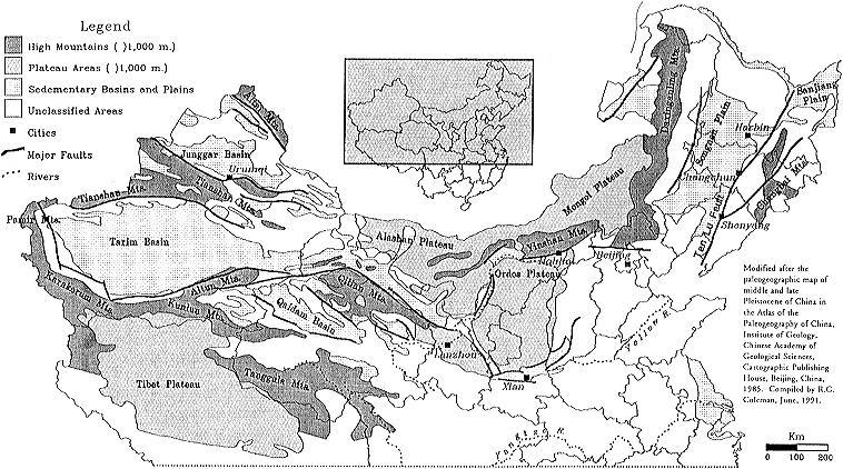
development of soil follows from the geologic substrates and climatic influences. (For details on geology of this region, see Wang et al., 1985; Ren et al., 1987; Zhang et al., 1984.)
In the west, the Himalayas and the immense Tibetan Plateau block moisture flows from the south, leaving the Tarim basin of Xinjiang among the driest regions on the planet. The less extensive uplifts of the east and the rising elevations of the Mongolian Plateau cause precipitation to decline as one moves away from the Pacific Ocean. However, the mountains, sandlands and sedimentary basins of the Northeast and eastern Inner Mongolia receive more than 350–500 mm of rainfall from the southeasterly summer (July–August) monsoon. According to the Trewartha climatic classification system, the eastern grasslands are middle-latitude steppe, whereas most of northwest China is middle-latitude desert (Xinjiang) or upland (Qinghai). The Mongolian high-pressure system ensures cold dry winters throughout northern China. Most precipitation comes in the summer, which may be hot, mild or cool depending on elevation. Compared to the grassland areas of North America, northern China is colder, generally drier in winter, more strongly seasonal with almost all rainfall during the summer growing season, and with greater variability in precipitation. Climatic variability and strong seasonality influence both primary and secondary production on China's grazinglands, causing nutritional stress for animals in winter and sometimes leading to starvation and heavy livestock losses.
The soils of the northeastern grasslands are Mollisols (Borolls) including chernozems, chestnut, and brown soils. The hot, dry regions of Inner Mongolia and Xinjiang have undifferentiated Aridisols, whereas the cold, dry Tibetan Plateau has Entisols, Inseptisols, and Spodosols of the Cryic great group. The Tibetan Plateau and the surrounding deserts form a large region in which soil development is almost nil. On the plateau this is caused by the prevalence of rugged topography, ice fields, and cold temperatures. In the gobi deserts of Inner Mongolia, Gansu, and Xinjiang, strong winds have blown the fine particles to the southeast, leaving a rock and gravel pavement with little or no soil. In addition, throughout northern China are large patches of sand, many of which appear to be the remnants of old lakes or inland seas. In the high-rainfall areas of the east, these "sandlands" support some of the most productive, but also most fragile, grasslands in China.
The regional vegetation map of China (Map 1-2) shows the distribution of grasslands and other grazinglands across northern China. The vegetation regions of the north reflect both the east-west precipitation gradient and the effect of the high elevations of the west. The relatively moist climate at the eastern end of this gradient supports tall grass meadows within the forest steppe region of the Northeast. Moving west, away from the influence of the southeastern monsoon and onto the higher elevations of the central Asian plateau, temperatures and rainfall decrease yielding, in the following order,
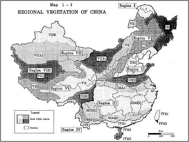
Map 1-2 Regional Vegetation of China
I. Cold-temperate deciduous needle-leaf forest region
II. Temperate deciduous broadleaf forest region
II1 Mixed broadleaf deciduous and needle-leaf evergreen forest zone
II2 Broadleaf deciduous forest zone
II2(1) Broadleaf deciduous forest subzone
II2(2) Subzone of broadleaf deciduous forest containing sub-tropical deciduous trees
III. Subtropical evergreen broadleaf forest region
IIIA Eastern evergreen broadleaf forest subregion
IIIA1 Mixed broadleaf deciduous and evergreen forest zone
IIIA2 Evergreen broadleaf forest zone
IIIA2(1) Evergreen broadleaf forest subzone
IIIA2(2) Subzone of evergreen forest containing tropical trees
IIIB Western evergreen broadleaf forest subregion
IIIB1 Sclerophyllous evergreen broadleaf woodland zone
IIIB2 Evergreen broadleaf forest zone
IIIB2(1) Evergreen broadleaf forest subzone
IIIB2(2) Subzone of evergreen forest containing tropical trees
IV. Tropical seasonal rain forest region
IVA Eastern tropical seasonal rain forest subregion
IVA1 Transitionally seasonal tropical rain forest zone
IVA2 Seasonal tropical rain forest zone
IVB Western tropical seasonal rain forest subregion
V. Temperate steppe region
V1 Forest steppe zone
V2 Typical steppe zone
VI. High-cold meadow and steppe region
VI1 Forest meadow zone
VI2 Steppe zone
VII. Temperate desert region
VIIA Southern desert subregion
VIIA1 Semidesert and desert zone
VIIA2 Desert and bare gobi zone
VIIB Northern desert subregion
VIII. High-cold semidesert and desert region
typical steppe, semidesert steppe, desert, and bare gobi. In the west, vegetation is controlled by elevation. The same sequence (meadow, steppe, semidesert, desert) follows the descent from mountain to basin. The Tibet-Qinghai Plateau supports high-cold meadow and steppe in the east and south, and high-cold semidesert and desert in the north and west. The vast majority of the more than 2 million km2 of grazinglands in northern China occur in the central and western (drier) portions of the region. The mesic grasslands of the Northeast account for slightly more than 5% of the total. Thus most of the grazinglands are typical steppe, semidesert steppe, or desert.
More than 20% of the northern grazinglands are said to be unusable (Table 1-1), while an even larger portion are in a degraded state. There are many reasons for grassland degradation in northern China. In the mesic eastern regions, inappropriate conversion to agriculture is probably the leading
Table 1-1 Grasslands of Northern China, by Province or Region, 1989 (million hectares)
cause. In the drier west, human wood harvesting and overgrazing by livestock are probably more important. The grazinglands of northern China, although vast, are a threatened resource. More detailed descriptions of the topography and vegetation of each region of the northern grasslands appear below.
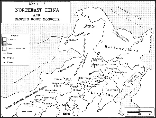
THE NORTHEAST
The three provinces of the Northeast (previously known as Manchuria)—Heilongjiang, Jilin, and Liaoning—account for about 5% of the northern grasslands (Map 1-3). The relatively high rainfall, dense human population, and intensive development of this region have converted most grasslands to farmlands, leaving only the northern and western borders as grazinglands. In these provinces, elevations are higher in the north than in the south and fall sharply from the Daxinganling [Great Hinggan] Mountains in the west, onto the Manchurian plain in the east. In the northernmost province of Heilongjiang, the Xiaoxinganling [Lesser Hinggan] and Yilehuli mountains exceed 1000 m, creating a topography of rolling hills, pock-marked by alkali basalts of recent volcanic origin. Three major east-flowing rivers empty onto the Sanjiang Plain at the northeastern tip of the province, forming a low-lying swampy delta. The Songnen Plain, a faultbound depression in central Heilongjiang, is the northern extension of the huge North China Plain. The southeast mountainous area is defined by the active Tan Lu. fault, whose uplift produced the Changbai Mountain range that ends as a peninsula into the Bohai Sea. The Songnen and Sanjiang Plains have been formed by subsidence, whereas recent uplifting along active faults has produced the mountain ranges bordering these depressions. During the Pleistocene, alluvial deposits developed along the flanks of the depressions and lacustrine deposits formed in the central areas of the plains. The geology of Jilin Province is closely related to that of Heilongjiang. Central Jilin contains the southern extension of the Songnen Plain, bounded on the west by the Daxinganling and the east by the Changbai Mountains. Liaoning, the southernmost of the three provinces, faces southward to the Bohai Sea. Eastern Liaoning is dominated by the Changbai Mountains, whose western boundary is marked by the active, strike-slip, Tan Lu fault. The Songliao Plain stretches into the center of the province and steps up gradually westward to the Mongolian Plateau.
The "forest steppe" of western Manchuria is distinguished from the "typical steppe" in neighboring Inner Mongolia by its higher rainfall (350–600 mm), dark chernozem soils, and higher productivity. The dominant grasses of the Northeast are Stipa grandis and Aneurolepidium chinense, commonly called ''sheepgrass" [yangcao]. Even as late as the Qing Dynasty (1644–1911), this area was heavily forested, although recent immigration and development have greatly reduced natural vegetation of all types and caused serious soil erosion.
INNER MONGOLIA
The Inner Mongolia Autonomous Region (IMAR) occupies the center of China's northern tier, bounded on the east by Manchuria and on the west by Xinjiang. Covering nearly 1.2 million km2, Inner Mongolia accounts for 12.3% of China's total area but has less than 2% of its people. The region, which has less than 5 million hectares of cultivated land, or about 5% of China's total, boasts somewhere between one-quarter and one-third of the nation's grasslands. In 1989, the IMAR had nearly 87 million hectares of natural grassland, covering 70% of the region's total area and supporting more than 37 million large livestock, sheep, and goats. Animal products account for about 11% of the region's gross output (4.5 billion yuan in 1988). Only the far-western regions of Xinjiang and Tibet have comparable grazingland and livestock resources.
Eastern Inner Mongolia is dominated by the Mongolian Plateau, which extends southeastward to the Daxinganling Mountains that rise to average heights of 1000–2000 m. The Mongolian Plateau was uplifted to its current level of about 1000 m during the late Pleistocene. Many lakes that existed prior to this uplift have since disappeared, leaving desert areas—the source of extensive aeolian loess deposits to the southeast. In the central portion of Inner Mongolia the Yellow River makes a huge loop northward around the Ordos Plateau, where it forms local deltas and rich alluvial soil. The Ordos Plateau (approximately 1200-m elevation) to the south of the Yellow River loop was uplifted and tilted westward at the same time as the uplift of the Mongolian Plateau. The southern part of the Ordos is covered by thick aeolian loess deposits, alkali lakes, and extensive deserts. Further west, Inner Mongolia is dominated by the sandy and rocky deserts of the Alashan Plateau, which also rises to nearly 1000 m above sea level.
There is considerable variation in the composition and productivity of the Inner Mongolian grasslands. A strong rainfall gradient divides the region into a series of vegetation zones, from the wetter east to the drier west. Chinese scholars classify these grasslands into four (sometimes five) basic types (Li, 1962; Li et al., 1988; Liu, 1960; Liu et al., 1987; and Wang et al., 1979). "Meadow grassland" or "meadow steppe" [caodian caoyuan], at the eastern edge of Inner Mongolia on both sides of the Daxinganling Mountains and in neighboring Manchuria, is the tallest and most productive of the grassland types. Vegetation in this area includes the mountain plants, Filifolium sibiricum, Festuca ovina, and Stipa baicalensis, and at lower elevations, Aneurolepidium chinense. "Typical grassland" [dianxing caoyuan], a midheight, heavy-cover community, runs across the vast castanozem plateau west of the mountains and is dominated by Stipa grandis, Aneurolepidium chinense, and Agropyron michnoi. "Dry grassland" [ganhan caoyuan] is a shortgrass region further west, beyond the Yinshan Mountains, where a Stipa krylovii, S. bungeana, and Thy-
mus serpyllum community develops. Finally, in the southwest, on the Wulanchabu and Ordos plateaus, brown calcareous soils support thin grasslands of Stipa breviflora, Artemisia frigida, and Caragana shrubs. Chinese scholars sometimes distinguish between the "desert grassland" or "wasteland" [huangmo], marked by patches of grass and shrubs separated by bare soil, and the "sandy desert" [shamo], which supports the sparsest growth of all.
Although the grasslands of Inner Mongolia are immense, government figures suggest that both the quantity and the quality of this resource are in decline. In 1989, Inner Mongolia had 86.7 million hectares of grassland, of which 18.7 million hectares (21.6%) were deemed "unusable" and another 29.9 million hectares (34.5%) were considered "deteriorated" or "seriously deteriorated," leaving only 38.1 million hectares (43.9%) both usable and in good condition. Compared to 1965, the area of the region's grasslands is said to have decreased by 6.2 million hectares, deteriorated grasslands have increased by 28.7 million hectares, and total grass production has dropped by 30% (IMAR, 1990).
Human land use in Inner Mongolia varies across grassland types and along a second gradient that runs from the agricultural lands of the warmer, wetter south to the grazinglands of the cooler, drier north. During the recent past, the boundary between these two economies has moved north as Chinese settlers have invaded, irrigated, and cultivated the steppe. During the 1960s and 1970s, this expansion increased in both speed and extent, before stabilizing in the early 1980s as a result of policy reversals and environmental realities. Three sites visited by the CSCPRC delegation—Wengniute Banner in the Keerqin [Horqin] "sandland" of eastern Inner Mongolia, the "typical" grassland of Xilingele League, and the "dry" grassland of Siziwang Banner—illustrate the patterns of natural resource utilization, environmental degradation, and public policy debate in the IMAR.
Wengniute Banner occupies the Keerqin sandland, north of Chifeng. Records from the Liao Dynasty (A.D. 907–1125) show that this was once an area of substantial forests and grasslands that supported a modest population of nomadic herders. Only in the nineteenth century did significant numbers of Han agriculturalists begin moving into the region, putting marginal lands under cultivation and reducing the area available for grazing. This trend continued during the twentieth century, reaching a frenzied pace in the 1950s and 1960s when large numbers of Han migrants were transferred to border areas and peasants were admonished to "grow grain everywhere."
The climate (300–400 mm of precipitation), soils (brown to chestnut), and vegetation (a transitional zone between forest and steppe, dominated by species of Ulmus, Ephedra, Caragana, Artemisia, Salix, and Hedysarum ) of Wengniute are adequate to sustain a reasonable level of human and livestock population. However, the tremendous influx of people, expansion of agriculture, reduction of grazingland, and increase in livestock numbers have degraded vegetation
throughout this region and left the land bare in many areas. For example, from 1950 to 1990 in the village of Wulanaodu, which is located in the center of the banner, the human population increased by more than 13 times, from 23 to 328, and the number of livestock 44 times, from 266 to 12,031, with significant growth recorded for animal numbers of all types. Villagers recall that in the 1950s the grass was dense and tall, whereas today it is sparse and short. As the vegetation has disappeared, sand dunes have begun to move across the landscape. According to one estimate, 47% of Wengniute has been degraded, salinized, and/or alkalinized. Despite desperate attempts to erect windbreaks, fix dunes, and reintroduce vegetation, it remains questionable whether the natural resources of this area can sustain the current pressure of people and animals, much less the heavier loads that seem destined for the future.
Some 250 km northwest of Wengniute, across the Daxinganling Mountains and up on the Mongolian Plateau, is the "typical" grassland of Xilingele League.1 There are differences in natural conditions between these two sites: The former has sandy soils, whereas the latter exhibits greater variety, from basaltic-derived soils in the south, through sandlands in the center of the region, to granitic-derived soils in the north. Xilingele is also higher in altitude (ca. 1000 m versus 500 m) and has a lower average annual temperature (0°C versus 6.3°C), but precipitation in the two areas is comparable (300–400 mm), and both have experienced the same centrally directed influx of Han migrants, sharp increases in human and livestock populations, and expansion of cultivated land.
What most clearly distinguishes the two areas is the density of their human populations. Wengniute Banner, south and east of the Daxinganling, in a slightly warmer region more suitable for agriculture and closer to the center of the Han population, has about 35 persons/km2, whereas Xilingele, which is on the plateau, cooler, less amenable to agriculture, and further from the cities of northern China, has no more than one-tenth that number. Some grasslands of Xilingele, near settlements and watering sites, show signs of degradation, but in most places the vegetation remains intact. Differences of human impact are more significant than natural conditions in accounting for the variation in the state of these grasslands.
The reforms of the 1980s, which were designed to increase production, have had uncertain effects on the grasslands of these areas. Throughout China, grazing animals have been distributed to producers under the "household responsibility" system. At sites visited in Xilingele and Wengniute, family herds reportedly range in size from 25 to 100 cattle and 100 to 300 sheep, with a few horses. However, there is considerable variety in the allocation of range-lands. In Xilingele, each herding family is assigned a fodder field, where it has exclusive right to cut grass for winter feed, whereas pastures are held in common and herders are free to graze their animals on any available land. Because
this practice is thought to encourage overgrazing and conflicts with the Ministry of Agriculture's goal of encouraging ownership and management of land by producers, local officials are now experimenting with the "double responsibility" system, whereby both flocks and fields are assigned to individual households. It remains to be seen, however, how land tenure policies will affect the environment. In Wengniute, both animals and land have been distributed, but given the density of livestock and the paucity of vegetation, double responsibility may do little to reduce overgrazing.
Siziwang Banner,2 160 km north of the Inner Mongolian capital of Hohhot, offers another perspective on the grasslands of Inner Mongolia and the factors affecting them. The area north of Hohhot lies in the transition zone between agriculture and animal husbandry. The elevation of this area rises from 1063 m in Hohhot, to between 1500 and 2000 m along the crest of the Daqing Mountain range, 40 km north of the city, then falls to 1200 m on the northern plain. Rainfall levels also rise and fall across this elevational gradient from 417 mm in Hohhot, to 600 mm in the mountains, and then down the scale as one moves northward across the plain to the Mongolian border.
Both the northern and the southern slopes of the Daqing are covered with a sandy loam soil and have sufficient rainfall to support wheat, potatoes, and oats. With the decline of rainfall north of the mountains, agriculture gives way to animal husbandry. High in the Daqing, the growing season is too short and further north the climate is too dry to sustain agriculture. Attempts to expand cultivation into these areas have produced environmental problems and conflicts over public policy.
Beginning in the Great Leap Forward (1958–1960) and during the two decades that followed, the government urged farmers to expand cultivation, particularly of grain, into the mountains and grazinglands. In this process, Han agriculturalists displaced Mongol herders, who were forced either to shift to agriculture or to migrate north. In warm, moist years, these efforts succeeded, encouraging further attempts to expand cultivation. Inevitably, however, drier, colder weather caused crops to fail. To supplement marginal and uncertain agriculture, farmers in the Daqing mountains expanded their flocks of sheep that now feed on the reduced grazing areas. Chinese grassland scholars say that both agriculture and animal husbandry practices have contributed to degradation in this area and that because of the unrelieved population pressure, this process continues.
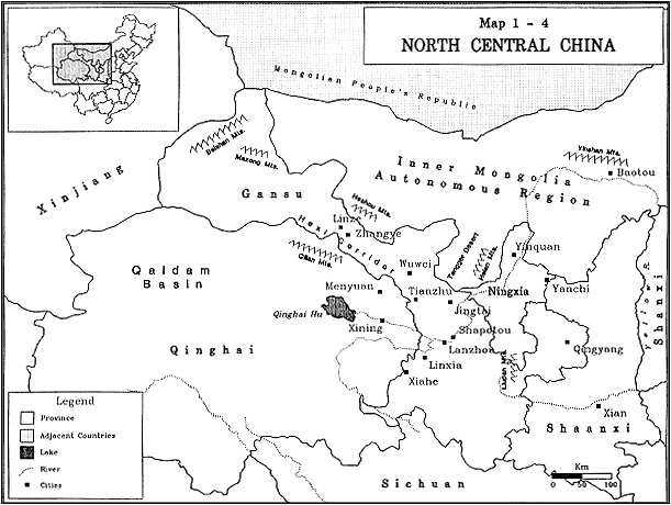
GANSU AND QINGHAI
Qinghai and Gansu Provinces (Map 1-4) are adjacent, the former encompassing the northeast corner of the Tibet-Qinghai Plateau, the latter wrapped in the shape of a great dumbbell around the northern and eastern base of the plateau. Qinghai, the largest province in China (not counting the "autono-
mous regions"), covers 720,000 km2, but its high, rugged terrain—80% of which lies at or above 3000 m—supports a population of only 4.3 million, or 6 persons per square kilometer. On the other hand, with more than 30 million hectares of usable grassland, it supports many sheep (13.5 million in 1989), cattle and yaks (5.2 million), and other livestock. Animal husbandry accounts for 10% of this province's gross value of output. Qinghai leads the nation in wool production per household.3
The interior of Qinghai consists of extensive river and lake systems, which include the large inland Qaidam basin and the headwaters of the Yangtze, Mekong, and Yellow rivers. Qinghai's high plateau terminates on the north at the Altun and Qilian mountains, which reach more than above 4000 m before descending into the Hexi Corridor in neighboring Gansu. Large-scale uplift since the Quaternary raised the plateau by 1000 meters in the early Pleistocene, and by more than 1000 meters in the mid to late Pleistocene. Glaciers developed during the early Pleistocene uplift were first replaced by freshwater lakes. As the climate grew more arid in the late Pleistocene, these lakes became salty, and sand-gravel deserts formed, creating a high alpine desert.
Gansu province occupies a natural corridor between eastern China and Xinjiang province in the west. Eastern Gansu, which lies within the Ordos Plateau, is drained by the Yellow River. The Hexi Corridor runs through the center of the province, bounded by the Qilian Mountains on the south and the Alashan Plateau, a high desert, on the north. To the west, Gansu merges with the Tarim Basin and Beishan range of Xinjiang.
Although the climate of Gansu is arid, the longer growing season and the supply of irrigation water from the Qinghai Plateau support a dense population of 21.4 million people in an area of 450,000 km2. The Hexi Corridor, gateway to the ancient Silk Road, is the grain belt of the northwest. Because the annual precipitation in the region is only 50–200 mm, 80% of the farmland is irrigated by melting snow from the Qilian Mountains that border the corridor on the south. Farming in the corridor is productive, although 10% of the cropland is so salinized that it is useless for agriculture. In 1987, Gansu reported 14.5 million hectares of grasslands, of which 8.5 million hectares were deemed usable. These grasslands, the largest and most fertile of which lie north and south of the Hexi Corridor, are home to more than 5 million cattle and nearly 9 million sheep. Animal husbandry accounts for slightly more than 5% of the Gansu economy.4 The vast alpine grassland on the Qilian Mountain is inhabited by minority groups, chiefly Yokous, Tibetans, and Mongols. On the northern fringe of the corridor are the Mazong and Heshou mountains, surrounded by desert (mostly gobi or gravel) and semidesert rangeland.
The Ningxia Hui Autonomous Region occupies a small wedge of land along the Yellow River, east of Gansu. Northern Ningxia includes an alluvial plain formed by loess deposits laid down by flooding of the Yellow River. Southern Ningxia extends into the loess area of the Ordos Plateau that rises to 2000 m.
Prior to the uplift of the Ordos Plateau, all of this region was part of a large lacustrine sedimentary basin. Today, half of Ningxia is covered by usable grasslands; it has the highest density of livestock of any province or region in northern China. Much of the herding is done by the Hui minority, which accounts for nearly one-third of the population.
According to scholars in the provincial capitals of Lanzhou and Xining, the animal herds of Gansu and Qinghai and the natural resource on which they rest are in trouble. The rangelands of Gansu supply too little winter forage, and agriculture in the Hexi Corridor has never been integrated with animal husbandry in the neighboring rangelands. Many animals are said to starve to death in severe winters, and serious weight loss occurs each winter, while agricultural by-products in the valley go unused. Meanwhile, the transformation of land for the expansion of agriculture in Gansu and Qinghai is said to have caused the natural grasslands to deteriorate. Since 1949, 380,000 hectares of rangeland have been converted to agriculture in Qinghai, but because of the deterioration of the soil, 278,000 hectares have been rendered useless for farming. Soil erosion and the formation of gullies in the loess plateau of eastern and central Gansu have been particularly serious. In the former "grain bank" of Dunzhiyan, 70% of the area is now classified as gully land, while only 30% remains usable upland. Soil fertility has also declined—in most soils, the organic matter content is less than 1%. In 1980, grain production per unit area was only one-third the national average, and in 1987, grain production per capita in the loess plateau of Gansu was no higher than the level of the early 1950s.5
The Haibei Research Station in the Menyuan Hui Autonomous County, 160 krn north of Xining, provides an example of an alpine meadow ecosystem. Menyuan County lies in a mountain basin (elevation 3200 m) south of the Qilian Mountain range and astride the Xining-Zhangye highway, the major trade route between Qinghai and Gansu provinces. The mean annual temperature in this area is –2.0°C and the mean annual precipitation is 500 mm. The soils are alpine shrub, alpine meadow, and swamp soils, rich in nitrogen, phosphorus, and potassium. Vegetation consists mainly of Kobresia meadows with Potentilla fruticosa shrubs, which have an aboveground net primary production of 190–340 g/m2 per year. Plant nutrient content is reputed to be high.
The Haibei station is located in the center of an agricultural/pastoral collective, the Menyuan Horse Farm, which was organized into a brigade (the level below a commune) during collectivization in the 1950s. The brigade, formerly a stud ranch set up in the 1930s to provide horses for the Chinese Nationalist army, covers approximately 400 km2, of which 260 km2 are dedicated to rangeland livestock (mostly yak and sheep), and nearly 46 km2 to hay (oats and barley), with additional land in rape (Brassica campestris). This area is home to 40 pastoralist households, mainly Tibetan, and a smaller number of Hui people, most of whom are engaged in agriculture.
Under the rural reforms, the collective was dissolved, and each household received approximately 300 sheep, 50–100 yaks, a few horses, and 3000 mu (1 mu equals 15 hectares) of winter pasture, which has been turned over to private use but remains titled to the brigade. Sheep herds are generally 3–3.5 times the size of yak herds, although yak and sheep have nearly equal forage demands. Each household maintains a fodder field of 20–30 mu (1–2 hectares), most of which are planted in oats with seeds supplied by the brigade administration. Summer pasture, which is located in the mountains some distance from the permanent settlements in the valley, is grazed communally. In fact, most of the pastoralists take their sheep herds off summer pasture in midsummer to trespass on other collective farms located on the north face of the Qilian Mountains in Gansu Province. Although grazing times are regulated and strictly enforced within the brigade, trespassing both by and against neighboring communities is common and tolerated. The major environmental and economic problem in this region, as elsewhere in China, is said to be degradation of the grasslands, caused by overgrazing and, in this case, the influence of burrowing rodents, especially the zokor (Myospalax baileyi). (Liu Jike et al., 1982)
Under contracts signed for the procurement of livestock and land from the brigade, herding households in this region must deliver 6% of their livestock each year to government agents, for which they receive a fixed below-market price. Surplus animals and animal products may be sold on the open market, which expanded steadily during the reforms of the mid-1980s. Since 1988, however, Beijing has tightened controls on markets for major animal products—wool, cashmere, meat, and hides. The government monopolizes wholesaling, and informants at Haibei agree that at present there is little possibility of selling more than an odd lamb or skin through the private market.
XINJIANG
The Xinjiang Uighur Autonomous Region (Map 1-5), with 1.6 million km2 and 14.3 million people, is the largest and one of the least densely populated regions of China. The topography of Xinjiang, represented in one of its Chinese ideographs (shown at right), is defined by three mountain ranges; the Altai in the north, Tianshan in the center, and Kunlun in the south (the three horizontal lines), separating two large desert basins, the Junggar above and Tarim below (the two rectangles). Smaller intermontane basins occur throughout the Tianshan ranges (3000–5000 m). The alluvial sediments of the Junggar Basin began accumulating at the time of the collision of India with Asia in the early Tertiary. The huge Tarim Basin consists mostly of desert with thick alluvial deposits that continue to form from erosion of the surrounding Kunlun, Karakorum, Pamir, and Altun ranges. Major strike-slip faults along the boundaries of these mountains are responsible for their uplift by transpression.

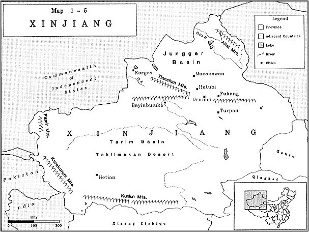
Frequent earthquakes attest to the continued northward movement of the Indian plate.
The climate of Xinjiang is governed by this topography. Prevailing northwest winds deposit most of their moisture in the Altai and Tianshan mountains, but contribute enough to the Junggar, either directly through rainfall or indirectly from snow melt, to support enough vegetation to stabilize the sand dunes of this basin. Much less moisture reaches the Tarim Basin, either from northern winds trapped by the Tianshan or from the south, where the Himalayas block the movement of moisture from the Indian Ocean. As a result, the Taklimakan Desert, which lies at the center of the Tarim, is extremely dry, its dunes unvegetated and unstable. Xinjiang as a whole is very dry, receiving less than 150 mm of precipitation annually. Animal husbandry is practiced mainly through transhumant movement from the mountain slopes in summer to the dry basin rims in the winter. Agriculture depends uniformly on irrigation.
According to a survey conducted by the Xinjiang branch of the Chinese Academy of Sciences (XISRD, 1989), natural grasslands cover 572,588 km2 (36%) of this region, although only 480,068 km2 are judged usable. More than 90% of the usable grasslands are grazed on a seasonal basis. In 1986, Xinjiang had 498,000 hectares of artificial, 578,000 hectares of improved, and 442,000 hectares of enclosed grasslands, resources that were expected to increase during the Seventh Five-Year Plan (1986–1990). There are more than 32 million domesticated grazing animals in Xinjiang. Sheep make up 70% of the total, followed by goats, cattle (including yaks), donkeys, and horses. In 1987, Xinjiang produced 2.2 billion yuan of animal products, which was 8.7% of the regions gross output.6
The major problems with grasslands in Xinjiang, as in other parts of China, are the shortage and low yield of winter pasture, the imbalance of distribution between water and grass, and the fluctuation of growth from year to year. In some parts of this region, the yield of grasslands in an arid year is only about half that for a normal year. As a result, animal husbandry is widely, but thinly dispersed. The main concentrations are in and around the mountain systems, where forage and water are most plentiful. According to the 1982 census, the most numerous ethnic groups in Xinjiang were Uighur (45.5%), Han (40.4%), and Kazakh (6.9%). Most animal husbandry is carried out by minorities: Kazakhs, Mongols, Kirghiz, and others. Uighurs and Chinese (Han) settlers are concentrated in the cities and agricultural areas.
POLICY AND LAND USE IN NORTHERN CHINA
A detailed picture of the political, social, and economic contexts in which animal husbandry is practiced in northern China awaits future research. Indeed, one of the themes of this report is the paucity of knowledge about pastoral peoples and systems in China, and the importance of work in the
social sciences to complement and inform the study of the grasslands themselves. Research on these topics will surely point out the wide variety of practices in different times, places, and sectors. Given these limitations, it is nonetheless possible to make some general statements about the social structures and land use practices of people in northern China.
Human land use in northern China varies with temperature and moisture. The warmer, wetter zones are intensively cultivated. In recent years, agriculture has been expanded through a combination of irrigation schemes, immigration from China proper of farmers with the requisite technical skills, and political pressure from Beijing to open up marginal lands. As temperature and moisture decline, pure agriculture gives way to a mixed pastoral-agricultural economy. In these areas, animal husbandry is sometimes limited to the feeding of animals in pens. Finally, the coldest, driest regions, where agriculture is impossible, support extensive pastoralism. The pattern most common in these areas is seasonal migration of grazing animals to take advantage of distant grasslands during the summer and return in winter to a fixed home base. A major limiting factor for animal husbandry throughout northern China is winter feed, which can come either from winter pastures or from fodder cut and stored for this purpose. True nomadism, the continuous movement of herders and animals without fixed abode, which was once a standard practice among pastoral peoples of this region, is no longer found in China.
The distribution of people and animals in northern China reflects the limitations imposed by climate and vegetation. The eight provinces and regions covered in this study account for half the area of China, but contain less than 15% of the population. Excluding the highly developed Northeast, the population density of northern China is only one-twelfth as high as the rest of the country, whereas the numbers of grazing livestock in this area exceed those of human beings by 60% (Table 1-2).
The spectrum of economic activity in northern China corresponds roughly to the distribution of ethnic groups, with certain minorities—primarily Mongols in Inner Mongolia, Hui in Gansu and Ningxia, Tibetans on the high plateau, and Kazakhs in northern Xinjiang—dominating the pastoral economy, and Han (Chinese) concentrated in agriculture. This pattern reflects both the persistence of established ethnic minorities and associated pastoral techniques and the more recent arrival of Han immigrants who have opened up new lands to cultivation. The migration of Han agriculturalists into the eastern regions of Manchuria and Inner Mongolia has taken place over the past century or more and has been driven in part by spontaneous forces arising from the migrants themselves. Historically, there has been much less movement of Han to the more remote and climatically harsh western regions of Xinjiang, Qinghai, and Tibet. The pace of migration to all inland frontiers picked up after 1949 as the rulers in Beijing promoted, and in some cases compelled, the transfer of Han soldiers and settlers from China proper to border lands for many of
Table 1-2 Human and Grazing Livestock Population, Northern China, by Province or Region, 1989 (millions)
the same reasons that motivated their imperial predecessors: to relieve population pressure in the south and east, to expand the area under cultivation, and to secure control over strategically sensitive areas. The result of these policies has been to intensify an established Han dominance in the east and transform the demographic profile of the west. Tables 1-3 and 1-4 show the distribution of ethnic groups in the region covered by this study, in broad categories for the most recent census (1990) and in greater detail, where the numbers are available, for the previous census (1982).
Finally, since 1949, the social, political, and economic organizations that sustain herding (and everything else) in China have undergone major, rapid, and repeated changes, initiated by authorities in Beijing in a series of wavelike campaigns and applied in various ways throughout the country. The broad effect of these changes has been to transform the ownership and management of livestock from private hands and local elites that dominated the pre-Communist period, to the collectives of the Maoist era (1949–1976), and finally to a larger role for private producers, still operating within the framework of state control, during the last decade.
The ''reform'' era in China dates from 1978, when Deng Xiaoping and the Communist Party leadership launched a program to revive rural production, first by increasing the prices paid by the state for procurement of basic commodities, and later by leasing land and other assets to private producers and freeing prices and markets to open competition. These reforms have had dramatic effects, increasing the total output of the rural sector and raising the standard of living of many farmers and animal husbandrists. It is important to
Table 1-3 Minority Population, Northern China, by Province or Region, 1990
|
Province/ Region |
Population |
Density (persons/km2) |
Minorities Numbers |
Percentage of Population |
|
Liaoning |
39,459,697 |
270 |
6,164,661 |
15.6 |
|
Jilin |
24,658,721 |
132 |
2,517,624 |
10.2 |
|
Heilongjiang |
35,214,873 |
78 |
1,990,770 |
5.7 |
|
Inner Mongolia |
21,456,798 |
18 |
4,158,076 |
19.4 |
|
Gansu |
22,371,141 |
49 |
1,856,152 |
8.3 |
|
Ningxia |
4,655,451 |
90 |
1,548,081 |
33.3 |
|
Qinghai |
4,456,946 |
6 |
1,876,527 |
42.1 |
|
Xinjiang |
15,155,778 |
9 |
9,460,152 |
62.4 |
|
China |
1,133,682,501 |
118 |
91,200,314 |
8.0 |
|
SOURCE: 1990 Population Census of China. |
||||
point out that greater economic freedom has produced greater diversity, among sectors, regions, and individuals, so that simple generalizations do not hold and detailed studies are required to describe the complexity of outcomes. Still, anecdotal evidence suggests that higher prices and freer markets have improved the lives of many rural folk, while in some areas, most notably Inner Mongolia, the per capita annual income of Mongolian herdsmen has been raised well above the level enjoyed by Han or Mongolian farmers. "It is quite common," observed one foreign scholar (Howard, 1988, p. 60) who traveled throughout this region in the early 1980s,
to see grassland Mongolians dressed in silk robes with silver buttons and jewelry, riding motorcycles instead of horses and camels, and living in yurts worth several thousand yuan with floors covered with expensive wool carpets.
Besides increasing the level of wealth, the reforms have reshaped the organization under which agriculture and animal husbandry operate. The "household responsibility" system, introduced in the early 1980s, is now the standard in rural China. Under this system, peasant households receive long-term (currently 15-year) leases on land in exchange for which they pay agricultural taxes and other fees. Peasant contractors are constrained by the need to procure some inputs, such as fertilizer, and to sell certain products through state agents at fixed prices, but they are free to decide what to grow and where to sell it and to keep the profits—benefits that can be great or small depending on the quality of one's land, access to markets, hard work, and good fortune.
In the animal husbandry sector, the household responsibility system began with the distribution of animals from the collectives to private households. Gradually, and unevenly from place to place, this has been followed by the
Table 1-4 Major Ethnic Groups in the Grassland Areas of Northern China, 1982 (1000)
|
Province/ Region |
Total |
Han |
Mongol |
Hui |
Manchu |
Tibetan |
Uighur |
Korean |
Kazakh |
|
Liaoning |
35,621.0 |
32,680.4 |
448.2 |
247.7 |
1,997.5 |
0.1 |
0.0 |
194.9 |
0.0 |
|
Jilin |
22,552.0 |
20,703.1 |
105.9 |
109.1 |
515.0 |
0.0 |
0.1 |
1,116.6 |
0.0 |
|
Heilong jiang |
32,822.4 |
31,200.7 |
94.8 |
127.2 |
909.9 |
0.1 |
0.1 |
447.4 |
0.0 |
|
Inner Mongolia |
19,110.2 |
16,163.8 |
2,457.0 |
159.8 |
229.9 |
1.1 |
0.1 |
11.8 |
0.0 |
|
Gansu |
19,635.2 |
18,066.0 |
9.1 |
1,010.9 |
7.6 |
281.5 |
0.5 |
0.3 |
1.2 |
|
Ningxia |
3,856.6 |
2,606.6 |
0.9 |
1,241.1 |
7.4 |
0.0 |
0.0 |
0.1 |
0.0 |
|
Qinghai |
3,841.8 |
2,309.6 |
44.5 |
542.4 |
2.8 |
753.0 |
0.0 |
0.2 |
1.0 |
|
Xinjiang |
12,879.1 |
5,174.4 |
109.7 |
553.5 |
8.0 |
3.7 |
5,911.1 |
0.5 |
876.0 |
|
China |
1,003,790.5 |
936,521.1 |
3,402.2 |
7,207.8 |
4,300.0 |
3,822.0 |
5,917.0 |
1,783.2 |
878.6 |
|
SOURCE: 1982 Population Census, 10 Percent Sampling Tabulation, Beijing, October 1983. |
|||||||||
introduction of "double responsibility," which combines the distribution of animals with the leasing of land, usually high-quality fields for the growing of fodder or winter pastures, which are the most valuable and may be most susceptible to degradation from overgrazing. In exchange, the herders are required to deliver or sell at fixed prices to state agents live animals and animal products in quantities stipulated in the contracts that give them control over these assets. The herders are then free to sell surplus meat, wool, and other products on the open market, although the limits on transportation and the scale of the markets involved often make it difficult to exploit this opportunity. Much of the concern in China about the state of the grasslands and of the discussion over what Chinese can do to preserve this resource focuses on the impact these reform policies are having on the grassland ecosystem.
HUMAN IMPACT ON THE GRASSLAND ECOSYSTEM
For more than a quarter century, from the Communist victory in 1949 until his death in 1976, all areas of Chinese public (as well as private) life were imprinted with the thoughts of Mao Tse-tung. The policies of the Maoist era were marked by the belief that people are China's greatest resource and that human will, organization, and labor can overcome all obstacles, including the limitations of the natural environment. Given this view, it was logical to move large numbers of peasants into marginal, frontier areas, many of which had been devoted to animal husbandry, so that the resources could be "reclaimed" for more productive and efficient uses such as growing grain. Today, the results of this philosophy and the policies it engendered are apparent throughout northern China.
"Degradation" is the word heard most often in government offices and research institutes charged with minding China's grasslands. This process, by which vegetation is reduced and soil exposed and eroded, when taken to the extreme, renders fragile grazinglands useless. Most experts in China believe that China's grasslands are being degraded and even desertified at a rapid and accelerating rate. Although the figures are elusive, estimates of the total area of degraded grassland in China range in the tens of millions of hectares. (See, for example, ACIAR, 1987, p. 10.) Many Chinese maintain that the chief causees of this decline are human impacts: increase in population, overextension of agriculture, and overgrazing by domesticated animals.
The expansion of China's population nationally and in the border areas in particular is a long-term and accelerating trend. After the last great change of dynasties, the number of Chinese nearly tripled, from 150 million in 1600 to 430 million in 1850. A century of war and natural disaster limited growth to only 540 million by 1949, but peace and prosperity have led to another doubling, to 1.1 billion, in 1990. The greatest increases in absolute numbers have occurred among the Han, who account for more than 90% of China's popula-
tion, and surpluses generated in China proper have pushed migrants to the north and west. All these trends accelerated after 1949. During the first three decades of Communist rule, Beijing did little to check population growth, transferred Han soldiers and settlers to northern border areas, and promoted economic development with little regard for the effect on the surrounding environment.
The migration of the Han, both voluntary and government induced, has been accompanied by the expansion of agriculture into marginal lands, including rangelands. To some degree this has been a natural process: Chinese farmers who moved into new areas set about making a living by the means they knew best. Particularly during the periods of Mao Tse-tung's ascendance, the Great Leap Forward (1958–1960) and the Cultural Revolution (1966–1971), however, tremendous pressure was brought to bear on peasants and local officials to "grow grain everywhere." The cultivation of land previously devoted to grazing reduced the area available to feed livestock. Later, when crops grown in marginal areas failed, land erosion followed, and viable rangeland was lost—now and for many years to come.
Whereas the growth of human population and the expansion of agriculture have impinged on and reduced the grasslands, the number of animals that depend on this shrinking resource has increased exponentially. During the first 40 years of the People's Republic of China (1949 to 1989), the total number of grazing animals in China more than tripled, from slightly more than 100 million to nearly 340 million head.7 Whether these increases have exceeded traditional stocking rates, whether they have reached a sustainable level, or whether they will continue are questions that merit further research. The effect of grazing on the northern grasslands as a whole is unclear, but heavily grazed areas show a level of degradation that gives cause for concern.
Many Chinese who study and help manage the grasslands believe that damage by overgrazing has been intensified by recent reforms, which have placed livestock in private hands whereas the rangelands are held in common. In this view, the reforms have achieved their principal goal of increasing the animal population, but have done so by making the grasslands a free, uncontrolled, and overused resource. Critics describe this situation as a "tragedy of eating from the common pot." The solution, some believe, is to expand the double responsibility system by which grazing areas and animals are assigned to the same households, and create a self-interest on the part of producers to maintain the balance between land and livestock.
Beijing's effort to deal with the problem of grassland degradation is contained in the Rangeland Law of the People's Republic of China, which was passed in 1985. This law focuses primarily on the effects of agriculture. It forbids farming and other activities that damage rangelands and empowers local governments "to stop anyone from farming a rangeland in violation of the provisions of the present law, to order the person to restore the destroyed
vegetation, and to pay a fine if serious damage has been done to the rangeland." The law makes no reference to the ownership or numbers of livestock and contains no provision for the distribution of rangeland. A narrow reading of the law has persuaded some Chinese grassland experts that the government has no intention of limiting livestock numbers or forcing herders to take responsibility for rangeland management. In this view, the only viable remedy and thus the mission of Chinese scientists is to find the means to increase grassland production. However, officials in Beijing present a different picture.
Responsibility for implementing the rangeland law and for managing other aspects of rangeland policy is assigned to the Ministry of Agriculture. Li Yutang, chief of the ministry's Grasslands Division, explains that rigid enforcement of this law is infeasible, because (1) it would displace farmers who had opened new lands at the government's urging and, if denied their fields, would have no other means of livelihood; (2) it would require fiats from Beijing that would not be well received by local authorities; and (3) it would do nothing to solve the basic problem of overgrazing. Instead, the ministry is pursuing a gradual policy that is to unfold in four steps: first, distribution of animals among individual households (essentially complete); second, distribution of grazing lands among these households (now in progress); third, assignment by local officials of carrying capacities for each piece of land (in the future); and finally, implementation of incentives and sanctions that will persuade producers to limit their flocks to the assigned capacities. Li points out that the key features of this policy are to find and maintain a balance between animals and vegetation, and to arrive at this balance through local decision making and market mechanisms. It remains to be seen how Beijing will achieve acceptable stocking rates, while at the same time leaving decisions in this area to producers and local authorities.
The analysis of many Chinese grassland experts, whose views are reported in the following chapters, points to a downward spiral of man, animals, and vegetation. Too many people and too many animals are pressing too hard on a fragile ecosystem. The grassland area has been reduced by the expansion of agriculture and other forms of human intervention. The number of animals is steadily rising, while the resource on which they depend diminishes. Current policies encourage herders to consume rather than conserve vegetation. Unless this cycle is broken, grassland degradation will continue and desertification will follow.
The fact that the people with the most experience and greatest responsibility for China's grasslands hold this opinion makes it worth pondering. At the same time, the authors of this report suggest that future research examine more carefully the human and other impacts on China's grasslands, and ask whether this ecosystem as a whole is in decline and, if so, what the causes are. Population growth may or may not affect the grasslands, depending on what new arrivals do. An increase in the number of urbanites may have little effect
on distant rangelands, whereas an increase in pastoralists may force them to divide a fixed number of animals into smaller herds. Overextension of agriculture may have devastating effects on a restricted area but have little relevance for the rangelands as a whole. Without more precise, detailed information on the location and effect of these external factors, it is difficult to weigh their impact.
Of particular interest is the proposition advanced by many Chinese grassland experts that the increases in animal numbers and thus overgrazing are leading causes of grassland degradation. The panel notes several reasons to question whether the current stocking rates in the northern grasslands are abnormal or excessive, and therefore whether grazing is indeed having the impact some Chinese believe. Figures for the number of animals in pre-1949 China are fragmentary and unreliable, making it difficult to trace changes in herd size over time. Whatever livestock the Communists inherited after decades of chaos and war, the number was undoubtedly well below the level this area must have supported earlier and could be expected to support under "normal" conditions. Officials responsible for collecting data and for making and carrying out economic plans after 1949 have had a strong incentive to underestimate economic indicators at the time of the Communist takeover, in order to show the largest and most rapid gains thereafter. Finally, a comparison of provincial, regional, and national figures suggests that the size of the herds in the northern grazinglands may in fact be leveling off. These figures, presented in Table 1-5, show that in five regions where extensive grazing is widely practiced—Inner Mongolia, Ningxia, Gansu, Qinghai, and Xinjiang—the total number of grazing animals increased from 52.5 million in 1952 to 110.3 million in 1978, for an average annual increase of 2.9%, and from 110.3 million to 126.1 million between 1978 and 1988, for an average annual increase of 1.3%. By contrast, the average annual increases for China as a whole were 2.5% from 1952 to 1978, and 2.2% from 1978 to 1988. The initial sharp rise and later flattening out of the growth rate of herds in the northern and western rangelands may suggest that (1) prior to 1949, the number of animals in this region had fallen well below the carrying capacity of the land; (2) by the late 1970s, three decades of peace had restored the herds to a level the ecosystem could sustain; and/or (3) the smaller increase in animal numbers in the 1980s represents normal fluctuation in a system that has found its approximate range.
Is there a long-term, continuing increase in the number of animals in China that, if left unchecked, will graze the land to oblivion? Or are China's herds fluctuating, perhaps at some elevated but temporary level, around a "normal" capacity that these rangelands have sustained in the past and can sustain in the future? These are some of the questions that our initial examination suggests might guide future research.
Table 1-5 Grazing Livestock, by Province or Region, 1949–1988 (million)
|
Province/ Region |
1949 |
1952 |
1965 |
1978 |
1988 |
|
Heilongjiang |
1.7 |
2.7 |
3.5 |
5.1 |
5.6 |
|
Jilin |
1.7 |
2.4 |
3.0 |
3.5 |
4.7 |
|
Liaoning |
— |
3.8 |
— |
4.3 |
5.9 |
|
Inner Mongolia |
— |
13.3 |
— |
30.4 |
36.3 |
|
Ningxia |
1.2 |
2.2 |
3.9 |
3.5 |
4.6 |
|
Gansu |
6.6 |
8.6 |
12.2 |
14.1 |
16.7 |
|
Qinghai |
12.5 |
15.7 |
26.4 |
38.5 |
35.9 |
|
Xinjiang |
10.4 |
12.7 |
26.5 |
23.8 |
32.6 |
|
China |
102.4 |
138.3 |
223.2 |
263.8 |
326.9 |
|
SOURCES: Heilongjiang: Heilongjiang tongji nianjian (1990), 230; Jilin: Jilin shehui jingji tongji nianjian (1990), 209; Liaoning: Liaoning jingji tongji nianjian (1990), 423; Inner Mongolia: Neimenggu tongji nianjian (1989), 182; (1990), 150; Ningxia: Ningxia tongji nianjian (1990), 169; Gansu: Gansu tongji nianjian (1989), 177; Qinghai: Qinghaisheng shehui jingji tongji nianjian (1990), 140; Xinjiang: Xinjiang tongji nianjian (1990), 220. |
|||||
NOTES
REFERENCES
Australian Centre for International Agricultural Research (ACIAR). 1987. Review of the Institute of Crop Breeding and Cultivation, Beijing and Grasslands Research Institute, Hohhot. Canberra: ACIAR.
Howard, Pat. 1988. Breaking the Iron Rice Bowl: Prospects for Socialism in China's Countryside. Armonk: M.E. Sharpe.
Inner Mongolia Autonomous Region (IMAR). 1990. Report of the IMAR Urban and Rural Construction and Environmental Protection Department. Neimenggu Ribao (Hohhot), (August 30, 1990), p. 3. Cited in Foreign Broadcast Information Service, FBIS-CHI-90-189, 24–5.
Li Bo. 1962. Basic typology and eco-geographical principles of the zonal vegetation in Inner Mongolia. Neimenggu daxue xuebao [Inner Mongolia University Journal (Natural Science Edition)] No. 2.
Li Bo et al. 1988. The vegetation of the Xilin River Basin and its utilization. Pp. 84–183 in Caoyuan shengtai xitong yanjiu [Research on Grassland Ecosystem] No. 3.
Liu Jike et al. 1982. The communities and density of rodents in the Haibei Alpine Meadow Ecosystem Research Station. Alpine Meadow Ecosystem 32–43.
Liu Zhonglin. 1960. Vegetational survey of Inner Mongolia steppe region. Neimenggu daxue xuebao [Inner Mongolia University Journal (Natural Science Edition)] No. 2.
Liu Zhonglin et al. 1987. Regional characteristics and utilization directions of natural resources in Inner Mongolia. Pp. 838–870 in Zhiwu shengtaixue keyan chengguo huibian [Collection of Scientific Research Achievements in Plant Ecology]. Hohhot: Inner Mongolia University Press.
Ren Jishan, Jian Chunfa, Zhang Zhengkun and Qin Deyu. 1987. Geotectonic Evolution of China. New York: Springer-Verlag.
Ren Jizhou. 1987. Practical significance of grassland agricultural systems for comprehensive development on the Loess Plateau. Proceedings of the Conference/Workshop on Farmers' and Graziers' Problems and Their Solutions on the Loess Plateau of China, 5–10.
Ren Jizhou and Ge Wenhua. 1987. Integrated report on the study of grassland farming ecosystem. Collection of Qingyang Loess Plateau Experimental Station, 5–18.
Wang Hongzhen et al. 1985. Atlas of the Paleogeography of China. Beijing: Cartographic Publishing House.
Wang Yifeng et al. 1979. Characteristics of vegetational zonation in Inner Mongolia Autonomous Region. Acta Botanica Sinica No. 3 (in Chinese).
World Bank. 1988. China: Development in Gansu Province. Washington, D.C.
Zhang, Z.M., J.G. Liou, and R.G. Coleman. 1984. An outline of the plate tectonics of China . Geological Society of America Bulletin 95: 295–312.
Zhongguo kexueyuan Xinjiang ziyuan kaifia zonghe kaochadui [Xinjiang Integrated Survey on Resource Development (XISRD), CAS]. 1989. Xinjiang xumuye fazhan yu buju yanjiu [A Study on Development and Layout of Animal Husbandry in Xinjiang]. Beijing: Science Press.


