
Malaysia
Jeffrey R. Vincent and Yusuf Hadi
The tandem of commercial logging and shifting cultivation has been blamed as the leading cause of deforestation in the humid tropics (Lanly, 1982; Myers, 1978). (The term deforestation is used here in the strict sense favored by Lanly [1982]: conversion of forests to a nonforest land use. Thus, logging of a primary—that is, virgin or old-growth—forest is not regarded as deforestation unless the logging is so intensive that tree cover is essentially eliminated.) In several countries, however, other agricultural activities are more responsible. Peninsular Malaysia provides a notable example. In the late 1800s, the peninsula was virtually completely forested. Today, natural forests cover less than half of their original extent. Forests have been converted primarily to agricultural use, but not by a process of shifting cultivation. Shifting cultivation affected less than 0.1 percent of the peninsula's land area in 1966 (Wong, 1971) and the late 1980s (Rambo, 1988).
Instead, tree crops represent the principal agricultural land use in Peninsular Malaysia. Rubber, oil palm, coconut, and cacao accounted for 83 percent of the area devoted to agriculture in 1988 (Ministry of
Jeffrey R. Vincent is an institute associate at the Harvard Institute for International Development, Harvard University, Cambridge, Massachusetts; Yusuf Hadi is dean of Fakulti Perhutanan (Faculty of Forestry) at the Universiti Pertanian Malaysia, Selang-or, Malaysia.
Agriculture [Malaysia], 1991). Unlike shifting cultivation, the opening of new areas for tree crops has not been driven by the need to replace abandoned, exhausted lands. New plantations represent net additions to an essentially permanently productive agricultural land base.
This profile analyzes the role played by tree crops in the conversion of forests in Peninsular Malaysia during the past century. It addresses four broad questions: (1) Are tree crop plantations a sustainable land use? (2) Are tree crop plantations economically feasible? (3) How have policies affected the expansion of tree crop plantations? (4) What are the environmental impacts of conversion of natural forests to tree crop plantations? In addition, deforestation projection rates up to the year 2030 are provided. It also highlights policy implications and identifies principal research needs.
Under Malaysia's federal constitution, individual states retain substantial autonomy over land development and forestry policies. Policies are coordinated more among the states of Peninsular Malaysia than between Peninsular Malaysia and either Sabah or Sarawak (Vincent, 1988). Because of this autonomy and because there are profound differences among the three regions in demography (Peninsular Malaysia had 82 percent of the nation's population in 1990), economic activity (Peninsular Malaysia is more industrialized and accounted for 84 percent of Malaysia' s gross domestic product [GDP] in 1987), and agricultural activity (74 percent of Malaysian land in agricultural use was in Peninsular Malaysia in 1990), this profile focuses only on Peninsular Malaysia.
DESCRIPTION OF PENINSULAR MALAYSIA AND ITS FORESTS
Malaysia is a federation of 13 states. Eleven of the states comprise Peninsular Malaysia, which was the British colony of Malaya until it became independent in 1957. The other two states, Sabah and Sarawak, share the island of Borneo with Brunei and Kalimantan (part of Indonesia).
Topography, Climate, and Soils
Peninsular Malaysia is located entirely within the equatorial zone. It covers 13.2 million ha (40 percent of Malaysia's land area). Aiken et al. (1982) and Tija (1988) have summarized the peninsula's physical and climatic characteristics. Figure 1 shows how climate and topography vary within the peninsula. No part of the peninsula is more than about 150 km from the sea. The interior of the northern
FIGURE 1 Climate and topography of Peninsular Malaysia. A. Mean annual rainfall in millimeters: <2,000, 2,000–2,500, 2,500–2,750, 2,750–3,000, 3,000–3,250, and >3,250. B. Mean annual bright sunshine in hours: <2,100, 2,100–2,200, 2,200–2,400, 2,400–2,500, and >2,500. C. Mean annual temperature in °C: <26.1, 26.1–26.6, 26.6–27.2, and >27.2. D. Elevation in meters: <300, 300–600, and >600. Source: Tija, H. D. 1988. The physical setting. Pp. 1–19 in Key Environments: Malaysia, Earl of Cranbrook, ed. Oxford, U.K.: Pergamon. Reprinted with permission from the publisher, © 1988 by Pergamon Press Ltd.
two-thirds contains mountain ranges that run approximately north-south. The highest peak, Gunung Tahan, is 2,188 m in elevation. Mountains give way to low hills in the southern cone of the peninsula. Coastal plains extend along the Strait of Malacca on the west and the South China Sea on the east and are wider on the west. About two-thirds of the peninsula is less than 300 m above sea level.
The combination of an equatorial location, proximity to the sea, and low relief results in a climate that varies relatively little during the year or within the peninsula. Most of the peninsula receives more than 2,400 hours of bright sunshine per year. The mean annual temperature ranges from 26.1° to 27.2°C and is highest in the low-lands just inland from the west coast. The mean annual rainfall ranges from less than 1,800 to more than 3,600 mm. The wettest regions are the foothills near the east and northwest coasts. The peninsula has a weak monsoonal climate.
The peninsula's soils are heavily weathered (thus, they are often very deep), highly leached, and typically quite acidic (pH 4.2 to 4.8). They contain little organic matter and low levels of plant nutrients. Six of the 10 U.S. Department of Agriculture (USDA) soil orders occur: Entisols, Histosols, Spodosols, Oxisols, Ultisols, and Inceptisols (Tija, 1988). The last three types have good to excellent physical properties for agriculture.
Lee and Panton (1971 [cited in Ariffin and Chan, 1978]), drawing on the work of Wong (1971) (according to Soong et al., 1980), proposed a soil suitability classification for Peninsular Malaysia that continues to be used for land use planning. The system divides the peninsula 's soils into five suitability classes (classes I–V), which are differentiated by the number of limitations in using the soils for agriculture. Ariffin and Chan (1978) suggest that potential agricultural land should best be confined to soils with, at most, one serious limitation for agriculture (classes I–III, which total 5.9 million ha). Barlow (1978), Lee (1978), and Aiken et al. (1982) suggest that 6.3 million to 6.5 million ha is suitable for agriculture. The Economic Planning Unit (Malaysia) (1980) of the Prime Minister 's Department favors an estimate of 6.3 million ha.
Population
Peninsular Malaysia's population was estimated to be 14.7 million in 1990 (Department of Statistics [Malaysia], various issues). Approximately half of the population is Malay, one-third is Chinese, and one-tenth is Indian. The remainder includes the aboriginal people who preceded the Malays, the Orang Asli, whose population totaled only about 60,000 in 1980 (Rambo, 1988).
TABLE 1 Total and Urban Population Growth in Peninsular Malaysia, 1835–1990
|
Total Population |
Urban Population |
|||
|
Year |
Total (1,000s) |
Growth Rate (percent)a |
Total (1,000s) |
Growth Rate (percent)a |
|
1835–1836b |
281 |
— |
NAc |
— |
|
1891 |
944d |
2.2 |
NA |
— |
|
1901 |
1,531d |
4.8 |
NA |
— |
|
1911 |
2,339 |
4.2 |
250 |
— |
|
1921 |
2,907 |
2.2 |
407 |
4.9 |
|
1931 |
3,788 |
2.6 |
571 |
3.4 |
|
1947 |
4,908 |
1.6 |
930 |
3.0 |
|
1957 |
6,279 |
2.5 |
1,667 |
5.8 |
|
1970 |
9,182 |
2.9 |
2,635 |
3.5 |
|
1980 |
11,437 |
2.2 |
4,251 |
4.8 |
|
1990 |
14,667 |
2.5 |
6,870e |
4.8 |
|
a This is the growth rate during the interval since the preceding point estimate of population. b Excludes Pinang, Melaka, and the Orang Asli. c NA, Not available. d Based on rates of growth for the Federated Malay States, given in Lim (1977: Appendix 1.2). e Estimated by the authors by using the growth rate for the previous decade. SOURCES: Aiken, S. R., C. H. Leigh, T. R. Leinbach, and M. R. Moss.1982. Table 8.10 in Development and Environment in Peninsula Malaysia.Singapore: McGraw-Hill International; Department of Statistics (Malaysia).Various issues. Monthly Statistical Bulletin: Peninsular Malaysia.Kuala Lumpur: Department of Statistics; Ooi Jin Bee. 1976. PeninsularMalaysia. London: Longman. |
||||
Table 1 presents the growth trends for total and urban populations from 1883 to 1990. The rate of population growth in Peninsular Malaysia was 2.2 percent/year during 1989–1990. The World Bank (1990) projects the rate to remain at this level during 1988–2000 and to fall to 1.2 percent/year during 2000–2025. The urban population has been growing more rapidly than the rural population. Approximately 47 percent of the population lived in urban areas in 1990, up from 27 percent at the time of independence, 1957. Better economic opportunities (for example, manufacturing jobs) help to explain the trend toward urbanization. Only 8 percent of households in urban areas were classified as poor in 1984, whereas 25 percent of households in rural areas were classified as poor (Ministry of Agriculture [Malaysia], various issues). In 1987, the mean annual gross house-
hold income was 72 percent higher in urban areas than it was in rural areas (Ministry of Agriculture [Malaysia], 1990).
Peninsular Malaysia's population density is low compared to that of most developing countries. In 1988, total land per capita was 0.95 ha, agricultural land in use was 0.28 ha per capita, and forest area was 0.45 ha per capita (Ibu Pejabat Perhutanan, Semenanjung Malaysia, 1990; Ministry of Agriculture [Malaysia], 1990).
Domestic Economy
The Malaysian government does not report all economic statistics separately for Peninsular Malaysia. For this reason, much of the information in this section pertains to Malaysia as a whole.
In 1988, Malaysia's gross national product (GNP) was 85.8 billion Malaysian dollars (M$; M$2.62 = US$1.00 in 1988). In per capita terms this was US$1,940, which makes Malaysia a middle-income developing country (World Bank, 1990). In 1988, exports equaled 64 percent (M$55.3 billion) of the GNP, while imports equaled 50 percent (M$43.3 billion) (Ministry of Agriculture [Malaysia], 1990). GNP per capita grew at an average rate of 4.0 percent/year during 1965–1988, which was tied for the highest rate among middle-income countries (World Bank, 1990). Continued strong economic performance is needed to enable Malaysia to service its debt. The country's long-term debt service as a percentage of GNP was 16.5 percent in 1988 (World Bank, 1990).
AGRICULTURE
Agriculture (including forestry and wood products) is a major sector of Peninsular Malaysia's economy and is important on a global basis as well. Malaysia is the world's largest producer and exporter of natural rubber (34 percent of global production and 40 percent of global exports in 1989), palm oil (59 percent of global production and 69 percent of global exports in 1989), and tropical logs and sawn wood (25 percent of global production and 78 percent of global exports in 1989) (Food and Agriculture Organization, 1991; Ministry of Primary Industries [Malaysia], 1990). With the exception of tropical logs, production and exports of these products are concentrated in Peninsular Malaysia. Agriculture, forestry, and fisheries accounted for 21 percent of Malaysia's GDP and employed 31 percent of Peninsular Malaysia's work force in 1988 (Ministry of Agriculture [Malaysia], 1990; World Bank, 1989).
Peninsular Malaysia's agriculture is based overwhelmingly on exotic
crops: rubber, oil palm, rice, and cacao and, to a lesser extent, coffee, pineapple, tobacco, sugarcane, and maize (Hill, 1982). This is because the peninsula was among the last regions in Asia to be settled by agriculturalists. Production, exports, imports, and consumption of major agricultural products in Malaysia in 1989 are summarized in Table 2. Malaysia is unique among countries in southeast Asia in that rice is not its most significant crop in terms of either area cultivated or tonnage of output (Barlow and Condie, 1986). Cereal production —almost entirely rice—was only 0.10 metric tons per capita in Malaysia during 1986–1988 (World Resources Institute, 1990).
In 1988, Malaysia exported M$22.1 billion of food and agricultural products (including forestry and wood products) and imported M$7.8 billion of such products. This contributed to a net agricultural trade surplus of M$14.3 billion (Ministry of Agriculture [Malaysia], 1990), which was more than the country's total trade surplus in 1988. The export value of rubber and oil palm products alone totaled M$10.4 billion, more than the value of total imports of food and agricultural products. The export value of forestry and wood products totaled M$7.5 billion in 1988. Because of its diversified economy, food makes up a smaller share of Peninsular Malaysia's imports (8 percent in
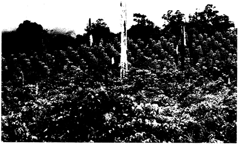
A farm that grows mixed crops is situated on land cleared by slash-and-burn techniques in Malaysia. Credit: James P. Blair © 1983 National Geographic Society.
TABLE 2 Production, Consumption, and Trade of Major Agricultural Products in Malaysia, 1989
|
Metric Tons (1,000s) |
||||
|
Product |
Production |
Exports |
Imports |
Consumption |
|
Palm oil |
6,055 |
4,948 |
41 |
1,148 |
|
Rubber |
1,419 |
1,487 |
122 |
54 |
|
Rice |
1,094a |
2a |
97a |
1,289a |
|
Palm kernel oil |
965 |
634 |
0 |
331 |
|
Meat (including poultry) |
438 |
6 |
53 |
485 |
|
Cacao |
255 |
169 |
0 |
86 |
|
Pineapple |
180 |
18 |
0 |
162 |
|
Copra and copra cake |
91 |
42 |
6 |
55 |
|
Coconut oil |
41 |
54 |
15 |
3 |
|
Edible vegetables, roots, tubersa |
NAb |
134 |
280 |
NA |
|
Sugar and sugar productsa |
NA |
209 |
647 |
NA |
|
Animal feeda |
NA |
450 |
736 |
NA |
|
Cereals and cereal preparations other than ricea |
NA |
34 |
2,012 |
NA |
|
a 1987 data. b NA, Not available. SOURCES: Department of Statistics (Malaysia). Various issues. Ministryof Agriculture (Malaysia). 1988. Import and Export Trade in Foodand Agricultural Products: Malaysia 1987. Kuala Lumpur: Ministryof Agriculture; Ministry of Agriculture (Malaysia). 1990. Agricultural,Livestock, and Fisheries Statistics for Management: Malaysia 1980–1988. Kuala Lumpur: Ministry of Agriculture; Ministry of PrimaryIndustries (Malaysia). 1990. Profile: Malaysia's Primary Industries(Malaysia). 1990. Profile: Malaysia's Primary Commodities. KualaLumpur: Ministry of Primary Industries. |
||||
1988) than in the case of the average middle-income country (11 percent) (Department of Statistics [Malaysia], various issues; World Bank, 1990).
MANUFACTURING
Peninsular Malaysia's economy is increasingly dominated by the output of manufacturing sectors. Although Malaysia's agricultural GDP grew 3.7 percent/year during 1980–1988, its manufacturing GDP grew 7.3 percent/year (World Bank, 1990). In 1988, manufacturing and services accounted for 64 percent of Malaysia's GDP (World Bank, 1989). Nearly all of Malaysia 's output of manufactured goods is produced in Peninsular Malaysia.
Land Use
Table 3 summarizes land use in Peninsular Malaysia in 1966, 1974–1975, and 1981 and provides information about land use for agriculture in 1988. The Ministry of Land and Cooperative Development (Malaysia) plans to carry out an updated land use survey under the Sixth Malaysia Development Plan (which covers the period 1991–1995).
The area in agricultural use increased from 21 percent of the peninsula 's land area in 1966 to 31 percent in 1988. Most of the increase had occurred by 1981, and most was due to the expansion of tree crop plantations. The four major tree crops—rubber, oil palm, coconut, and cacao—covered 16 percent of the peninsula's land area in 1966 and 26 percent in 1988. The agricultural area in 1988—over 4 million ha—was about two-thirds of the area considered suitable for agriculture in the peninsula.
Most of the agricultural conversion by the early 1970s had taken place in the southern and western lowlands, where rubber was concentrated. Since then, extensive conversion to oil palm has occurred in the eastern lowlands, and oil palm has replaced much of the rubber in the western lowlands.
Forests
The lowland forests of Malaysia, Brunei, the Philippines, and western Indonesia are dominated by tree species in the family Dipterocarpaceae. According to Whitmore (1988:21): “There are no other forests anywhere in the world which have so many genera and species of a single tree family growing together in the same place.” This ecologic characteristic, coupled with wood properties that allow the many species to be aggregated into a relatively small number of commercial groups with broadly similar properties, helps to explain why the timber harvested from these forests has dominated world trade in tropical timber since the end of World War II (Laarman, 1988).
FOREST FORMATIONS
Whitmore (1988) classified Peninsular Malaysia's forests into 10 forest formations. The small area of northwestern Peninsular Malaysia, which has a seasonally dry climate—climatically atypical for Peninsular Malaysia—is where (1) semievergreen rain forests, more common in Thailand and Burma, are found.
Forests on permanently wet soils include (2) mangroves on the coasts and (3) freshwater swamp forests and (4) peat swamp forests
TABLE 3 Land Use in Peninsular Malaysia, 1966–1988a
|
Hectares (1,000s) |
||||
|
Land Use |
1966 |
1974–1975 |
1981 |
1988 |
|
Urban and associated areas |
134 |
199 |
251 |
— |
|
Agriculture |
2,736 |
3,565 |
4,101 |
4,160 |
|
Perennial crops |
2,092 |
2,782 |
3,340 |
3,485 |
|
Rubber |
1,775 |
2,048 |
1,969 |
1,569 |
|
Oil palm |
100 |
487 |
1,063 |
1,527 |
|
Coconut |
176 |
203 |
179 |
210 |
|
Cacao |
<1 |
4 |
34 |
142 |
|
Others |
41 |
41 |
95 |
37 |
|
Paddy |
412 |
424 |
432 |
474 |
|
Horticulture |
200 |
274 |
243 |
179 |
|
Miscellaneous crops |
32 |
81 |
70 |
21 |
|
Improved permanent pasture |
<1 |
4 |
16 |
— |
|
Forest |
9,036 |
8,254 |
8,460b |
— |
|
Dryland forest |
7,852 |
7,182 |
7,437b |
— |
|
Swamp/wetland forestc |
1,176 |
1,070 |
1,023 |
— |
|
Shifting cultivationd |
8 |
2 |
— |
— |
|
Other |
1,310 |
1,019 |
432e |
— |
|
Scrub forest |
594 |
419 |
— |
— |
|
Grassland/scrub grassland |
404 |
170 |
— |
— |
|
Recently cleared land |
116 |
326 |
24 |
— |
|
Unused land |
62 |
6 |
— |
— |
|
Unclassified land |
134 |
98 |
190f |
— |
|
Total |
13,215 |
13,037 |
13,244 |
— |
|
a Data for 1966, 1974–1975, and 1981 are based on land-use surveys. Data for 1988 are based on annual records on land alienation and development. b Includes scrub forest, grassland/scrub grassland, and shifting cultivation. c Includes mangroves. d The estimates for 1966 and 1974–1975 exclude areas classified as scrub forest and grassland/scrub grassland. One might speculate that some of these areas were affected by shifting cultivation. If so, this could help explain why the forest inventories reported larger areas as being affected by shifting cultivation (see Table 4). e Excludes scrub forest and grassland/scrub grassland. f Includes unused land. SOURCES: For 1966, Wong, I. F. T. 1971. The Present Land Use of WestMalaysia (1966). Kuala Lumpur: Ministry of Agriculture and Lands;for 1974–1975, Economic Planning Unit (Malaysia). 1980. Land ResourcesReport of Peninsular Malaysia, 1974/ 1975. Kuala Lumpur: Prime Minister's Department; for 1981, Ministry of Agriculture (Malaysia). 1990.Agricultural, Livestock, and Fisheries Statistics for Management:Malaysia 1980–1988. Kuala Lumpur: Ministry of Agriculture; For 1988,Ministry of Agriculture (Malaysia). 1991. Perangkaan siri masa sektorpertanian. January 19, 1991. Memorandum. |
||||
in inland areas, depending on soil characteristics. (5) Woody beach vegetation is found in coastal areas.
The other five formations are found in inland areas that are not permanently wet. Most restricted in area are the (6) heath and (7) limestone forests. The remaining three formations account for the majority of the peninsula's forest area. Their distribution is largely determined by elevation. (8) Lowland evergreen rainforests once covered most of the peninsula up to an elevation of 750 m. Two floristic zones can be distinguished within this formation: lowland dipterocarp forests, which are found at elevations up to 300 m, and hill dipterocarp forests, which are found above these elevations. The demarcation is based on the distribution of seraya (Shorea curtisiï), which dominates ridges in the hill dipterocarp zone. (9) Lower montane rain forests are found between elevations of 750 and 1,500 m. They have a smoother, lower canopy than do lowland rain forests. They, too, can be divided into two floristic zones: the upper dipterocarp forests, which are found at elevations up to 1,200 m, and the oak-laurel forests, which are found above 1,200 m but below 1,500 m. The final formation, (10) upper montane rain forests, is found above 1,500 m.
BIODIVERSITY
In terms of biodiversity, Peninsular Malaysia's rain forests are among the richest ecosystems in the world. Ng (1988) estimated that 2,650 tree species occur naturally in Peninsular Malaysia. The low-land dipterocarp forests are the richest of the peninsula's forest formations. Butterflies and moths provide one exception to this pattern: most of the peninsula's 1,014 species are found at elevations of 600–1,000 m, and only 23 species are endemic (Barlow, 1988). Many endemic plant species are found in limestone forests.
Wells (1988) reported that 282 of the 370 bird species that make heavy or exclusive use of forests or the forest fringe are associated with lowland dipterocarp forests. He cited studies, carried out at the Pasoh Forest Reserve in the state of Negeri Sembilan and at the Kerau Game Reserve in the state of Pahang, that recorded 196 and 202 bird species, respectively, in areas of 2 km2 each. Yong (1988) reported that 33 families, 104 genera, and 203 species of mammals are native to Peninsular Malaysia. (In contrast, Denmark, which is also a peninsula and only slightly smaller in area, is home to only 13 families, 32 genera, and 45 species [Earl of Cranbrook, 1988].) Of the 203 mammal species, 194 have been sited in the forest, mainly the lowland dipterocarp forest (Earl of Cranbrook, 1988). According to Steven (1968
[cited in Earl of Cranbrook, 1988]), 78 percent of the mammal species other than bats are obligatory forest dwellers.
FOREST AREAS AND DEFORESTATION
The land use surveys (Table 3) are one source of information on forest areas in Peninsular Malaysia. The information they provide, however, is substantially less detailed and probably less accurate than the information generated by forest inventories carried out specifically to estimate forest areas and timber stocks. The most recent forest inventory in Peninsular Malaysia, Forest Inventory II, was carried out during 1981–1982 (Ibu Pejabat Perhutanan, Semenanjung Malaysia, 1987). It updated the peninsula 's first forest inventory, Forest Inventory I, which was carried out during 1970–1972 (Food and Agriculture Organization, 1973) and superseded interim estimates for 1980 made by the Food and Agriculture Organization (FAO) of the United Nations (1981) from projections based on Forest Inventory I and the 1974–1975 land use survey. Forest Inventory III is planned to begin in the early 1990s.
Table 4 presents the original estimates of forest areas from the two inventories, revised estimates from Brown et al. (1991b) based on a GIS analysis of the inventory maps, and the estimate for 1980 from FAO (1981). (The definitions of forest types used here are the ones used in the forest inventories.) Although they were calculated by a cruder method, the original estimates from Forest Inventories I and II are quite close to the revised estimates of Brown et al. (1991b). The original estimates slightly understated virgin forest areas and slightly overstated logged-over areas. The FAO (1981) estimate of total virgin forest area in 1980 is very close to the original and revised estimates for 1981–1982, but the FAO estimate of total logged-over area is 27 percent higher than the revised estimate from Forest Inventory II. Given the similarities between the original and revised estimates, but the more precise method used to generate the latter, the revised estimates are regarded as the best estimates.
According to the inventories, forests declined from 62 percent of Peninsular Malaysia's land area during 1970–1972 to 52 percent during 1981–1982. Areas of forest decreased for all types except dryland and inland swamp forests that have been logged over since 1966. The loss in virgin forest area, 1.179 million ha, was equivalent to more than four-fifths of the aggregate decrease in forest area, 1.411 million ha. Brown et al. (1991b) found, however, that most (59 percent) of the decrease in virgin forest area represented forests that were logged over but not converted to nonforest uses. Most conver-
TABLE 4 Forest Areas in Peninsular Malaysia, 1970–1982
|
Forest Inventories (1,000 ha) |
|||||
|
Original |
Revised |
FAO |
|||
|
Forest Typea |
1970–1972 |
1981–1982 |
1970–1972 |
1981–1982 |
1980 |
|
Virgin |
4,540 |
3,455 |
4,743 |
3,564 |
3,555 |
|
Below 1,000 mb |
3,787 |
2,915 |
4,001 |
3,003 |
2,804 |
|
Superior |
827 |
693 |
845 |
683 |
— |
|
Good |
1,150 |
848 |
1,160 |
916 |
— |
|
Moderate |
1,398 |
1,119 |
1,572 |
1,143 |
— |
|
Poor |
412 |
255 |
424 |
261 |
— |
|
Above 1,000 mb |
289 |
278 |
284 |
281 |
289 |
|
Inland swamp |
464 |
262 |
458 |
280 |
462 |
|
Logged-over |
3,332 |
3,046 |
3,175 |
3,042 |
3,875 |
|
Dryland |
2,981 |
2,748 |
2,846 |
2,727 |
3,562 |
|
Before 1966 |
1,714 |
488 |
1,615 |
481 |
— |
|
After 1966 |
1,267 |
2,260 |
1,231 |
2,246 |
— |
|
Inland swamp |
351 |
298 |
329 |
315 |
313 |
|
Before 1966 |
184 |
39 |
152 |
39 |
— |
|
After 1966 |
167 |
259 |
177 |
276 |
— |
|
Shifting cultivationc |
261 |
220 |
317 |
216 |
— |
|
Mangrove |
155 |
121 |
149 |
||
|
Totald 8,131 |
6,721 |
8,233 |
6,822 |
7,430 |
7,430e |
|
a Types are the categories used in the 1970–1972 and 1981–1982 forest inventories. The estimates of area of virgin forests in 1980 by the Food and Agriculture Organization (FAO) of the United Nations include forests termed “unproductive” by FAO (1981). b The elevation boundary is 1,300 m for the 1980 FAO (1981) estimates. Superior, good, moderate, and poor refer to timber stocking. c Includes only areas disturbed by shifting cultivation in 1966 or before. d Excludes mangrove forests. Sum of subtotals might not equal stated totals because of rounding. e Excludes shifting cultivation. SOURCES: For the original forest inventories, Food and AgricultureOrganization of the United Nations. 1973. A National Forest Inventoryof West Malaysia, 1970–72. FO:DP/MAL/72/009, Technical Report No.5. Rome, Italy: Food and Agriculture Organization of the United Nationsand United Nations Development Program; Ibu Pejabat Perhutanan, SememanjungMalaysia (Forest Department Headquarters, Peninsular Malaysia). 1987.Inventori Hutan Nasional II, Semenanjung Malaysia: 1981–1982. KualaLumpur: Ibu Pejabat Perhutanan, Sememanjung Malaysia; Food and AgricultureOrganization of the United Nations. 1981. Malaysia. A. PeninsularMalaysia. Pp. 277–293 in Forest Resources of Tropical Asia. UN 32/6.1301-78-04,Technical Report No. 3. Rome, Italy: Food and Agriculture Organizationof the United Nations. |
|||||
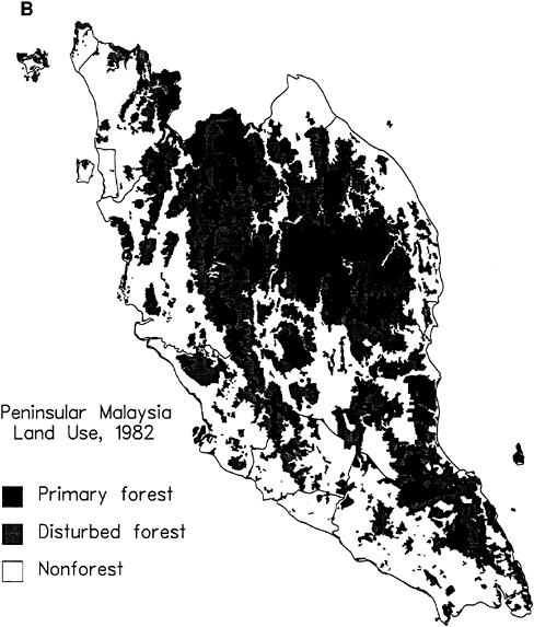
sion to nonforest uses occurred in forests that were already logged over at the time of Forest Inventory I. The maps in Figure 2 show areas of primary (virgin) and disturbed (logged over) forests in 1972 (Figure 2A) and 1982 (Figure 2B). The maps are based on an analysis by Brown et al. (1991b) and show that most logging in primary forests from 1972 to 1982 occurred in the northern and eastern parts of the peninsula and that most deforestation occurred in the southeast.
According to the land use surveys (Table 3), the changes in forest area were from 68 percent of land area in 1966 to 63 percent during 1974–1975 to 64 percent in 1981. Although the estimate for 1974–1975 is comparable to the estimate for 1970 –1972 from Forest Inventory I, the estimate for 1981 is substantially larger than the estimate for 1981–1982 from Forest Inventory II. One reason for the discrepancy is that the estimate of forest area in the 1981 land use survey included grassland/scrub grassland and scrub forest. These areas totaled 589,000 ha in 1974–1975, but this is much less than the discrepancy between the 1981 land use and 1981 –1982 inventory estimates, 1.638 million ha.
Is it possible that the areas of grassland/scrub grassland and scrub forest increased nearly threefold from the mid-1970s to the early 1980s? Traveling around the peninsula, one observes few large areas of grassland, but one does encounter large areas of scrub forest and unproductive or idle land in several states. These areas result from abandonment of agricultural land, failure to develop land after it has been logged in preparation for agricultural conversion, and degradation of forests to scrub forests following intensive logging. Logging became increasingly intensive in the 1970s and 1980s as timber markets developed for an increasing percentage of the tree species found in Peninsular Malaysia's forests. According to Forest Inventory II, only 7.5 percent of the total timber volume (for trees with a minimum diameter at breast height of 30 cm) in superior, good, and moderate virgin forests was in trees classified as noncommercial species (Ibu Pejabat Perhutanan, Semenanjung Malaysia, 1987). Moreover, the minimum commercial log diameter is as low as 27 cm in Peninsular Malaysia today. It is generally believed that commercial logging alone does not cause deforestation (see, for example, Lanly [1982]); however, when selective logging approaches clear-felling as a result of extraction of a high proportion of small-diameter trees, clearly commercial logging is a decisive factor.
Another explanation might be that the 1981 land use survey underestimated areas in agricultural use. Although statistics compiled by the Ministry of Agriculture (Malaysia) (1991) and presented in Table 3 indicate that the area in agricultural use in 1988 was little
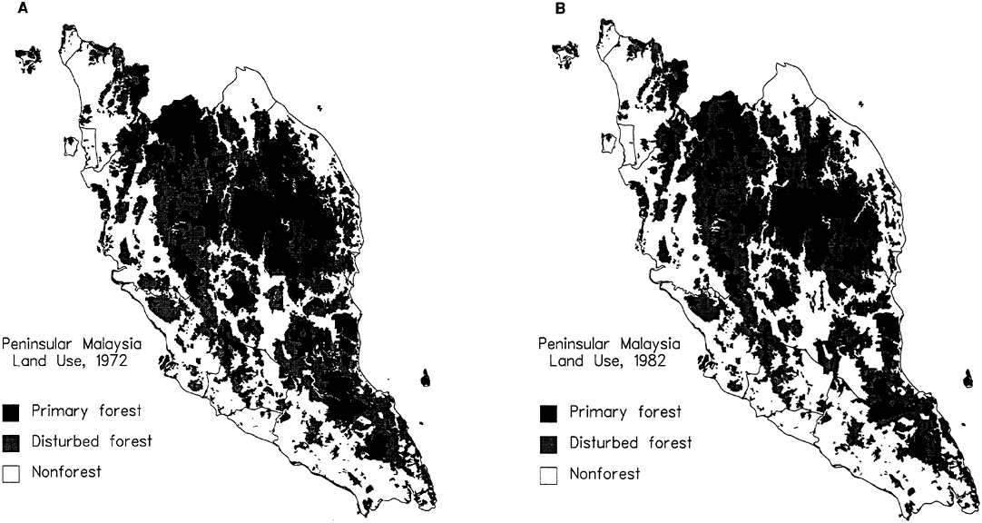
FIGURE 2 Areas of primary (virgin) and disturbed (logged over) forests in Peninsular Malaysia in (A) 1972 and (B) 1982. Source: Based on data from Brown, S., L. Iverson, and A. E. Lugo. 1991b. Land use and biomass changes of forests in Peninsular Malaysia, 1972–1982: Use of GIS analysis. Department of Forestry, University of Illinois, Urbana. Photocopy.
larger than the area indicated by the 1981 land use survey (4.1 million ha), Abu Bakar (1991) estimated the area in 1990 to be 4.8 million ha.
The 1966 land use survey and Forest Inventory I reported mid-year estimates for 1966 and 1972, while Forest Inventory II reported end-of-the-year estimates for 1981. Treating the estimates of total forest area from the three sources as point estimates for mid-1966, -1972, and -1982, the average annual rate of deforestation increased slightly from 134,000 ha/year during 1966–1972 to 141,000 ha/year during 1972–1982. The FAO's (1981) estimate for 1976–1980 was much lower, 90,000 ha/year. In percentage terms, the rate of deforestation rose slightly, from 1.55 percent/year during 1966–1972 to 1.88 percent/year during 1972 –1982. The latter rate is about three times the average for the tropics estimated by Lanly (1982).
Table 3 indicates that the major cause of deforestation was expansion of lands in agricultural uses other than shifting cultivation. The expansion of land in agricultural use from 1966 to 1974–1975, 829,000 ha, just about matched the decrease in forest, 782,000 ha. Most of the increase in agricultural area was due to expansion of area in perennial crops, 690,000 ha.
As implied above, the statistical correspondence between agricultural expansion and deforestation broke down after the early 1970s. The increase in the aggregate area in agricultural use between the 1974 –1975 and 1981 land use surveys was 89,000 ha/year, which is less than two-thirds the rate of deforestation on the basis of the 1970 –1972 and 1981–1982 forest inventories (141,000 ha/year). For every hectare recorded as being put into agricultural use, slightly more than one-half of an additional hectare was deforested.
Between inventories, the Forestry Department of Malaysia estimates total forest area by using annual records on areas logged and cleared for development. The most recent estimate is for 1988, 6.288 million ha (Ibu Pejabat Perhutanan, Semenanjung Malaysia, 1990). This implies a deforestation rate of 89,000 ha/year during 1982–1988, which is substantially lower than the rate during 1972–1982 but much higher than the annual average increase in agricultural area during 1981 –1988, 8,000 ha/year (Table 3).
PERMANENT FOREST AREAS
The high rates of deforestation in Peninsular Malaysia have raised concern about the area of land that will be permanently maintained under forest cover. If all the land that is suitable for agriculture is indeed ultimately developed for agriculture, then, at most, 6.7 million to 6.9 million ha of forest will remain. Some of this area will be converted to nonagricultural uses. Still, this constitutes 51 to 52 per-
cent of the peninsula's land area, which is much larger than the 29 percent in Thailand or the probably overstated 37 percent in the Philippines (World Resources Institute, 1990).
The official government policy as of the mid-1980s was to maintain at least 4.75 million ha as permanent forest estate (PFE) (Thang, 1986). Sixty percent of the PFE, or 2.85 million ha, would be productive forests, which would be managed for commercial timber production on a sustainable basis. The remainder would be protective and amenity forests, which would not be logged. Protective and amenity forests would protect watersheds, protect wildlife habitat, and provide recreational opportunities. Outside the PFE, an additional 0.59 million ha would be in national and state parks and wildlife reserves.
As of December 31, 1988, some 4.9 million ha were either classified or in the process of being classified as PFE (Ibu Pejabat Perhutanan, Semenanjung Malaysia, 1990). Although this figure makes it appear that the 4.75 million ha target has already been exceeded, little information is available on the actual forest cover on these lands. Illegal land clearing is known to have occurred within the PFE; moreover, land within the PFE is often legally declassified by state governments for development.
In 1988, the one national park in Peninsular Malaysia, Taman Negara, covered 0.43 million ha, while wildlife and bird sanctuaries covered 0.31 million ha (Kiew, 1991). About two-thirds (0.19 million ha) of the sanctuaries were within the PFE, so protected areas outside the PFE covered 0.55 million ha. This is slightly less than the target of 0.59 million ha. However, some 0.65 million ha has been proposed to be added to the park and sanctuary systems. The proposed area includes a second national park, at Endau-Rompin.
COMMERCIAL LOGGING
Commercial logging is a major source of degradation of virgin forests. Moreover, heavy, repeated logging of forests that results in conversion of the residual stand to scrub forest might explain why deforestation has evidently exceeded agricultural expansion since the early 1970s. Although logging as a source of forest degradation is an important issue, the more relevant issue here is whether logging and agricultural expansion are connected. Background information is provided in this section; most is taken from Vincent and Binkley (1991).
Assuming a timber growth rate of 1.0 to 1.5 m3/ha/year, the annual sustained yield from Peninsular Malaysia's productive PFE is in the range of 2.85 million to 4.28 million m3. In contrast, the harvest in 1990 was 10.6 million m3 (Ibu Pejabat Perhutanan, Semenanjung Malaysia, 1990). Why is the harvest so much larger than the sus-
tained yield? Conversion of forests outside the PFE to tree crop plantations is one reason. Another is harvesting of virgin forests within the PFE, since virgin forests generally carry higher stocks of commercial timber than do second-growth forests. Even if only an area consistent with sustained yield were harvested each year, harvests would exceed sustained yields until all virgin forests within the PFE had been logged over.
For these reasons, a rate of harvest that exceeds sustained yield does not necessarily imply that forest sector development is on an unsustainable trajectory. As timber becomes more scarce, rising stumpage values (log prices minus logging costs) should cause investments in forest management to increase and demand for timber to decrease. If these supply-and-demand adjustments occur, then the rate of harvest should decline and eventually stabilize at the sustained yield level.
These adjustments have been hindered in Peninsular Malaysia by the combination of low timber fees and insecure concession tenure. The fees that states levy on timber concessionaires—which include a combination of royalties assessed on extracted logs and premiums assessed on concession areas—drastically understate stumpage values (Gillis, 1988; Sulaiman, 1977; Teo, 1966; Vincent, 1990). Vincent (1990) estimated that forest revenue systems in Peninsular Malaysia captured only about one-fifth of the stumpage value of forests harvested during 1966–1985. Timber fees in most states of Peninsular Malaysia remained virtually unchanged from the early 1970s until the mid-1980s, despite evidence of rising stumpage values. Hence, these fees failed to signal increasing timber scarcity to State Forestry Offices and the federal Forestry Department, and they failed to generate the revenue needed for public forest management efforts. They also made available to land developers huge profits when forests were clear-felled in preparation for conversion to agriculture and other uses.
TREE CROPS VERSUS NATURAL FORESTS
Expansion of tree crop plantations has been the major cause of deforestation in Peninsular Malaysia (Table 5 and Figure 3). The expansion has occurred in three distinct phases: a rapid phase (49,000 ha/year) during 1904–1932, led by rubber; a slower phase (24,000 ha/year) during 1932–1966, also led by rubber; and the most rapid phase of all (57,000 ha/year) during 1966–1988, led by oil palm. Expansion by private estates dominated the first phase, while expansion by independent small landholdings was more important in the second. By 1961, the area of rubber in small landholdings exceeded the area in estates. Small landholdings in government-sponsored
TABLE 5 Average Annual Changes in Rubber and Oil Palm Areas in Peninsular Malaysia, 1900–1988
|
Hectares per Year (1,000) |
||
|
Decade |
Rubber |
Palm Oil |
|
1900–1910 |
22 |
0 |
|
1910–1920 |
66 |
0 |
|
1920–1930 |
36 |
2 |
|
1930–1940 |
14 |
1 |
|
1940–1950 |
5 |
1 |
|
1950–1960 |
11 |
2 |
|
1960–1970 |
18 |
23 |
|
1970–1980 |
−3 |
63 |
|
1980–1988 |
−21 |
67 |
|
SOURCES: Barlow, C. 1978. Table 2.2 and Appendix Table 3.2 in TheNatural Rubber Industry: Its Development, Technology, and Economyin Malaysia. Kuala Lumpur: Oxford University Press; Department ofStatistics (Malaysia). Various issues. Monthly Statistical Bulletin:Peninsular Malaysia. Kuala Lumpur: Department of Statistics; Khera,H. S. 1976. The Oil Palm Industry of Malaysia. Kuala Lumpur: PenerbitUniversiti Malaya; Ministry of Agriculture (Malaysia). Various issues.Statistical Handbook, Agriculture: Malaysia. (Before 1979: StatisticalDigest, Ministry of Agriculture and Lands, Peninsular Malaysia.)Kuala Lumpur: Ministry of Agriculture. |
||
land development schemes, particularly those under the Federal Land Development Authority (FELDA), became a significant source of expansion during the latest phase. Expansion by private estates was also important during the latest phase. Vincent and Hadi (1991) provide a brief review of these historical developments; Barlow (1978) and Bauer (1948) provide more detailed accounts for rubber, while Barlow (1986) and Khera (1976) do the same for oil palm.
From a policy standpoint, the bottom-line issue is whether Peninsular Malaysia has made itself better off, in the long run, by converting its natural forests to rubber and oil palm plantations. The following sections address four questions pertinent to this issue.
Are Tree Crop Plantations a Sustainable Land Use?
There is ample evidence that rubber and oil palm plantations can produce stable, in fact, increasing, yields on a long-term basis in Pen-
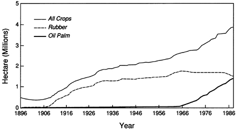
FIGURE 3 Trends in land use for Peninsular Malaysia. Sources: Barlow, C. 1978. Table 2.2 and Appendix Table 3.2 in The Natural Rubber Industry: Its Development, Technology, and Economy in Malaysia. Kuala Lumpur: Oxford University Press; Department of Statistics (Malaysia). Various issues. Monthly Statistical Bulletin: Peninsular Malaysia. Kuala Lumpur: Department of Statistics; Khera, H. S. 1976. The Oil Palm Industry of Malaysia. Kuala Lumpur: Penerbit Universiti Malaya; Ministry of Agriculture (Malaysia). Various issues. Statistical Handbook, Agriculture: Malaysia. (Before 1979: Statistical Digest, Ministry of Agriculture and Lands, Peninsular Malaysia.) Kuala Lumpur: Ministry of Agriculture.
insular Malaysia. Rubber has been grown on some sites for nearly 100 years, and oil palm for more than 70 years. Yields of both crops continue to increase as a result of the research efforts of the Rubber Research Institute of Malaysia (RRIM) and the Palm Oil Research Institute of Malaysia (PORIM).
Average yields of rubber rose from 492 kg/ha/year (estates and small landholdings combined) during 1929–1930 to 1,103 kg/ha/year for independent small landholdings and 1,428 kg/ha/year for estates in 1982 (Barlow, 1978; Barlow and Jayasuriya, 1987; see also Ministry of Primary Industries [Malaysia], 1990). Barlow (1978) reported rubber yields approaching 2,400 kg/ha/year for available varieties under good management in the 1970s, and he forecast potential yields of 3,500 kg/ha/year. Other investigators have predicted higher yields. Future increases in yields are probable because of the long time between the initiation of research to develop an improved variety and the commercial availability of improved planting stock.
Combined yields of palm oil and palm kernel oil on estates rose
from 1,850 kg/ha/year in 1960 to 4,155 kg/ha/year in 1982 (Barlow and Jayasuriya, 1987). Average yields for oil palm would be even higher if many of the prime coastal plain sites were not already under rubber (Hill, 1982). Average yields will rise as these sites are converted to oil palm.
Development of higher yielding varieties is the major reason for these increases, but improved management—planting and harvesting techniques, fertilization, and pest control—and, for rubber, use of chemicals that stimulate higher flows of latex have also been important (Barlow, 1978; Ministry of Primary Industries [Malaysia], 1990; Ng, 1983).
As with any agricultural crop, plantations need inputs to retain their productivity. Fertilizer is a key input for rubber and is even more important for oil palm (J. K. Templeton, World Bank, personal communication, 1990). Both RRIM and PORIM have carried out numerous studies of the responses of these crops to fertilization. Results of these studies can be found in Ng and Law (1971) [cited in Ooi, 1976]. Foster et al. (1985a,b), and Ahmad Tarmizi et al. (1986).
Ng (1983) expressed concern that the mechanical clearing and burning used during replanting of oil palm and the associated erosion and runoff might degrade the long-term productivity of the Ultisol and Oxisol soils. Can the productivity of Peninsular Malaysia's soils for growing rubber and oil palm be maintained in perpetuity through the application of fertilizers and other management inputs? To date, no obvious basis for answering in the negative has become apparent.
Are Tree Crop Plantations Economically Feasible?
Natural forests in Peninsular Malaysia appear to have been replaced by agricultural systems that have a long-term usefulness to humans. Conversion of forests to tree crop plantations could still be undesirable, however, if the economic costs of conversion exceed the economic benefits.
The growth of rubber small landholdings before independence, when government policies discriminated in favor of estates, and the growth of oil palm estates since the mid-1960s offer market-based evidence of the financial feasibility of these two crops. More formal evidence is provided by benefit-cost analyses of estates, independent small landholdings, and land development schemes. Benefit-cost analyses typically distinguish between financial and economic returns. Financial (sometimes termed “private”) returns are calculated with costs and benefits measured by market prices. Economic (sometimes termed “social”) returns are calculated with costs and benefits measured by
shadow prices. Shadow prices perform two functions: (1) they adjust market prices to remove distortions caused by policies or market imperfections, and (2) they quantify (value) the economic importance of goods and services that lack market prices altogether. In theory, shadow prices should reflect environmental impacts. Various aspects of the application of benefit-cost analysis techniques to land development schemes in Peninsular Malaysia have been discussed by Dixon (1977).
Estimates of financial and economic rates of return for investments in rubber and oil palm plantations are presented in Table 6 and Table 7. The studies cited used shadow prices, primarily to adjust the costs of labor, capital, and other inputs. None of the studies included shadow prices for environmental impacts. The moderate to high financial rates of return for rubber and oil palm estates and indepen-
TABLE 6 Internal Rates of Return for Rubber Plantations
|
Percent Return |
||
|
Plantation Type and Reference |
Economic |
Financial |
|
Estates |
||
|
Goering (1968 [cited in Lee, 1978]) |
— |
9.4, 10.9 |
|
Ariffin (1977 [cited in Ariffin and Chan, 1978]) |
— |
10.4 |
|
Bevan and Goering (1968 [cited in Khera, 1976]) |
15.4, 25.5 |
10.9 |
|
Goering et al. (1969 [cited in Khera, 1976]) |
— |
10.9, 13.8 |
|
Ng (1971 [cited in Barlow, 1978]) |
— |
12.4 |
|
Barlow (1978) |
31.5 |
14.3 |
|
Pushparajah et al. (1974 [cited in Ariffin and Chan, 1978; Barlow, 1978]) |
— |
23.5, 25.8 |
|
Independent smallholdings |
||
|
Barlow (1978) |
27.1 |
15.9 |
|
Land development schemes FELDA |
||
|
Syed Hussain (1972) |
9, 10 |
— |
|
Thillainathan (1980) |
13.5 |
4.4–19.9 |
|
Lim (1976) |
23.3 |
8.9 |
|
State |
||
|
Syed Hussain (1972) |
14–18 |
— |
|
Lim (1976) |
22.2 |
7.1 |
|
Fringe |
||
|
Lim (1976) |
22.7 |
6.0 |
NOTE: Entries with more than one value are ones for which rates of return were given under various assumptions.
TABLE 7 Internal Rates of Return for Oil Palm Plantations
dent rubber small landholdings explain why the private sector has historically been interested in investing in these crops. The tendency of both financial and economic rates of return to be higher for oil palm than for rubber indicates why, from the 1960s onward, many estates converted from rubber to oil palm and land development schemes increasingly emphasized oil palm. The positive and moderate to high economic rates (at least 10 percent in all but one instance) for land development schemes indicate that, on paper at least, the schemes earned an acceptable rate of return on public investment funds. However, the rates of return tended to be lower than those for other types of ownership, particularly in the case of rubber.
How Have Policies Affected Expansion of Tree Crop Plantations?
The inherent economic feasibility of tree crop plantations in Peninsular Malaysia indicates that fundamental economic forces, not mis-
guided policies, were primarily responsible for conversion of forests to agriculture. Three policies not specific to rubber and oil palm had a crucial, positive impact on the responses of smallholders and estates to these economic forces. First, the government invested in infrastructure, which enabled farmers to transport their products to markets and gain access to goods they did not produce themselves. Hence, farmers were not restricted to subsistence agriculture. Second, the government made it possible to obtain secure land title, generally under permanent or long-term leases (Barlow, 1978). This gave farmers confidence that they would reap the returns of the labor and capital they invested in tree crop plantations. Third, the government organized one of the most productive agricultural research systems in the tropics. As noted earlier, research at RRIM and PORIM is largely responsible for the increasing yields of rubber and oil palm, which has maintained the economic viability of these crops.
Policies within the rubber and oil palm sectors in Peninsular Malaysia were designed, for the most part, to make estates and smallholders pay their own way. In some instances, policies might even have forced plantations to bear more than a fair share of development costs. Evidence on these points in the case of rubber has been provided by Barlow (1978, 1984), Barlow and Drabble (1983), Barlow and Jayasurija (1986), and Power (1971 [cited in Barlow, 1978]).
The government levied taxes on rubber exports and tacked on additional cesses to raise the funds for rubber research and replanting grants (Barlow, 1984). Hence, the research and replanting that rejuvenated the industry after World War II “did not represent a transfer of resources from other sectors but, in effect, financing provided by the industry itself” (Lee, 1978:222). Even land development schemes had aspects of self-financing, as settlers were expected to pay back, with interest, the greater portion of government investments made on their behalf (Barlow, 1978). Singh (1968) estimated that 64 to 67 percent of government expenditures in three FELDA rubber schemes would be recovered from settlers by loan repayments and taxes.
Independent smallholders received few benefits from the government. During the 1920s–1940s, first the Stevenson Scheme and then the International Rubber Regulation Agreement hindered their expansion. According to Barlow (1978), “Without the[se] schemes the area of small landholdings in the Malay Peninsula would certainly have expanded far more” (p. 72). All small landholdings up to the mid-1950s were established without subsidies (Barlow and Jayasurija, 1986). Although they became eligible for replanting grants at that time, they appear to have borne a disproportionate share of the financing burden relative to the grants they received (Barlow, 1978).
In the 1960s, state and federal governments largely excluded small landholdings from developing new land because the government favored land development schemes (Barlow, 1984).
There were also restrictions placed on estates. After World War II, and particularly after independence in 1957, the government took steps to prohibit foreign-owned estates from acquiring new land, in an effort to create opportunities for local ownership, particularly by Malays (Barlow, 1984). This effort became more aggressive in the late 1970s when the National Equity Corporation began buying out foreign shares of estates (Barlow, 1984).
Thus, there is little doubt that policies hindered expansion of plantations by the private sector, especially smallholders. This contrasts with the active government promotion of land development schemes beginning in the late 1950s. These schemes might have earned double-digit economic rates of return, but were they necessary, and did they earn the maximum rates of return? Lee (1978) claimed that there was no indication that the private sector had an inability or unwillingness to undertake large land development schemes. Although Barlow (1986) and Barlow and Condie (1986) acknowledged that rural credit markets might have been unable or unwilling to provide the long-term credit needed by smallholders to establish sizable plantations, Barlow (1978) doubted that centralized development schemes were the only way to overcome this problem. He also disputed the argument that schemes were justified because of increasing returns to scale, particularly in the case of oil palm (Barlow, 1986). He argued that land development programs based on assisting independent smallholders would have been less costly for the government (the costs per hectare for rubber could have been reduced to two-thirds those of FELDA), would have enhanced efficiency and flexibility by placing more decisions in the hands of smallholders, and would have increased household income and economic independence.
Schemes did not always achieve their projected high rates of return. Fringe rubber schemes suffered from widespread abandonment and helped prompt the creation of the Federal Land Consolidation and Reclamation Authority (FELCRA) (Barlow, 1978). The poor performance of schemes has been linked to political motivations for land development (Guyot, 1971; Syed Hussain, 1972). Guyot (1971) concluded that a major reason why schemes were more successful in the state of Johor than in the state of Terengganu was because there was a greater tendency to develop land primarily to recruit and reward political supporters in Terengganu. Consequently, the sites were chosen poorly, and the state government provided little technical sup-
port to the settlers, who generally had little experience growing tree crops. Of 54 state and 43 fringe schemes for which land was alienated in Terengganu, only 22 and 1, respectively, were actually developed to the planting stage.
In addition to vote-seeking, schemes were sometimes motivated by rent-seeking. Land alienation for proposed schemes has been used as an excuse to grant timber concessions and thereby capture windfall stumpage values. Lee (1978) claimed that “There had been obvious cases of abuse in that the recipients of alienated land were more interested in removing the timber on the land rather than in its subsequent development” (p. 406), and he backed up this claim with data showing that only 58 percent of the land designated for agriculture during 1961–1970 was actually developed. No other historical data have ever been compiled on the amount of land that was alienated and logged, but never developed, in Peninsular Malaysia.
Although land development schemes do not appear to have been the most economically efficient means of promoting smallholder rubber and oil palm, this does not necessarily imply that less forest would have been converted in the absence of land development schemes. For example, estates and independent smallholders might have picked up the slack if policies had been less discriminatory toward them.
What Are the Environmental Impacts of Conversion of Natural Forests to Tree Crop Plantations?
The most obvious omission from benefit-cost analyses of rubber and oil palm plantations is the environmental impact. Environmental impacts of converting natural forests to tree crop plantations include increased soil erosion, increased variability of stream flows, and loss of biodiversity. Efforts to quantify these environmental impacts in economic terms and, thereby, to incorporate them directly into benefit-cost analyses remain rudimentary not only in Malaysia but also in most other tropical countries. Although resource economists have developed an array of nonmarket valuation techniques during the past 3 decades, these methods have received little application in developing countries. There are exceptions, however (Dixon and Hufschmidt, 1986; Dixon and Sherman, 1990; Hufschmidt et al., 1983; Vincent et al., 1991).
If the net environmental impacts of conversion of natural forests to tree crop plantations are negative, then market forces might lead to excessive expansion of plantations by the private sector (estates and independent smallholders). Furthermore, if decisions about land development schemes are based on project appraisals that ignore these
impacts, the decisions would be biased toward acceptance of the schemes. Hence, in the presence of negative environmental impacts and incomplete benefit-cost analysis, market and policy failures are created; these failures, in theory, might lead to the excessive conversion of natural forests to tree crop plantations.
The sections below review the physical information on the environmental impacts of conversion of natural forests to tree crop plantations. Although the information is not presented in economic terms, it does provide insights into the extent to which plantations provide environmental services comparable to those provided by natural forests. The review focuses on three services for which the most information is available: soil conservation, protection of water systems, and preservation of biodiversity. Most of the information pertains to rubber plantations, for which environmental impacts have been the most studied (Aiken et al., 1982). Brown et al. (1991a,b) provide information on a fourth service, the sequestration of carbon in woody biomass in natural forests (but not tree crop plantations).
SOIL CONSERVATION
For rubber and oil palm, the risk of soil erosion is greatest during plantation establishment and replanting. First, the natural forest (or the old plantation) is logged if commercial timber is present in sufficient quantities. Then, the remaining vegetation is allowed to dry; when it is sufficiently dry, it is pushed into piles and burned. Finally, heavy machinery is used to terrace the site (if it is a new plantation) and prepare it for the planting of ground covers and rubber trees or oil palms. Typically, several months elapse from the time the site is logged until ground cover is established, and several years pass before the tree canopy closes. The amount of erosion that occurs depends on the erosivity of the rainfall, the erodibility of the soil, and the speed at which ground cover is established and the tree crop canopy closes.
Mean annual erosivity exceeding 15,000 J/m2 places the entire east coast, the portion of the rubber belt on the west coast from Kuala Lumpur to Pinang, and most of the land development schemes in the states of Terengganu, Pahang, and Johor at high risk for soil erosion (Morgan, 1974 [cited in Soong et al., 1980]; Morgan, 1979). Policies and practices in Peninsular Malaysia recognize that erodibility increases with increasing slope. The Conservation Enactment requires that lands alienated for agriculture have a slope of less than 18.3°. Since World War II, terracing has become a standard practice for plantations established on slopes (Aiken et al., 1982).
Erosion was a greater problem earlier in the twentieth century because of the rubber estates' policy of “clean weeding”—removing all surface growth at the time of planting and keeping the soil surface clear even after trees became established. The rationale was that clean weeding would make nutrients more available and would inhibit diseases. Instead, it created serious erosion problems. Fermer (1939 [cited in Aiken et al., 1982]) estimated that rubber estates that were clean weeded lost an average of 8 cm of topsoil during 1902–1939. As a consequence, the productivity of vast areas was seriously reduced, and some plantations were abandoned (Barlow, 1978). Clean weeding began to be replaced after the mid-1920s by the planting of various types of leguminous ground covers soon after clearing (Barlow, 1978). Ground covers can reduce soil loss by 35 to 87 percent compared with the amount of soil lost from bare soils (Ling, 1976 [cited in Aiken et al., 1982:Table 7.2]). Moreover, the nitrogen provided by legumes saves on fertilizer expenses (Ti et al., 1971 [cited in Soong et al., 1980]). Although planted ground covers die off as the shade from rubber trees increases, they are replaced by natural ground covers that also control erosion (Rubber Research Institute of Malaysia, 1973 [cited in Soong et al., 1980]).
Even with a well-established ground cover and even after rubber trees have become established, soil erosion is greater than that in a natural forest. This is despite evidence that canopy interception of rainfall by mature rubber plantations is similar to that by natural forests (Aiken et al., 1982:Table 7.3). Morgan (1979) found that suspended sediment transport (for a strip 1 cm wide and 10 m long) in a rubber plantation was nearly double that in a natural forest. Aiken et al. (1982:Table 7.5) found that suspended sediment transport ranged from 0.058 to 2.63 cm3/cm/year for a rain forest to 6.66 to 41.89 cm3/ cm/year for a rubber plantation. Whether these rates are sufficiently high to undermine the long-term sustainability of rubber plantations is not clear.
Soil loss is probably less in oil palm plantations, even though the canopy remains more open for a longer period of time, because oil palm plantations tend to be established on slopes that are less steep (Aiken et al., 1982; Soong et al., 1980).
PROTECTION OF WATER SYSTEMS
Conversion to tree crop plantations has three principal environmental impacts on water systems: increased sedimentation, increased flooding, and increased pollution. Sedimentation increases because of greater soil erosion. Clean weeding caused particularly acute
sedimentation problems. Aiken et al. (1982) indicated that, “During the early 1930s, 2,835 ha (7,000 acres) of paddy land along the Malacca River had to be abandoned because of inundation by silt eroded from rubber estates upstream” (p. 122). They also indicated that the harbor at the mouth of the Malacca River was so badly affected by siltation that it had to be dredged on a regular basis. The off-site impacts of clean weeding led to the Silt Control Enactment of 1917, which “empowered the State Resident to take action against any person who allowed sediment eroded from his land to damage or interfere with the cultivation of neighbouring land” (Aiken et al., 1982).
Today, because of improved management practices, rates of soil erosion from agricultural land are generally much lower than those common in the early decades of the twentieth century, but because of the increased areas affected, river sediment loads may be no lower (Aiken et al., 1982). The sediment load in the Pahang River, which is the largest river in Peninsular Malaysia, more than tripled from the start of the twentieth century to 1975 because of increased logging and land conversion (Australian Engineering Consultants, 1974, cited in Aiken et al. [1982:Table 7.15]).
Rainfall runoff increases because of lower rates of canopy interception (at least in immature plantations), more compacted soil, and reduced humus. Increases in total annual runoff are relatively modest, about 10 percent (Tan, 1967; Hunting Technical Services et al., 1971 [both cited in Aiken et al., 1982]). Most of the increase comes during periods of peak rainfall, which increases the frequency and magnitude of floods (Aiken et al., 1982) and might diminish the recharging of aquifers. Daniel and Kulasingham (1964 [cited in Soong et al., 1980]) found that peak runoff per unit area was about twice as large in a catchment largely converted to rubber and oil palm as in one that was undisturbed natural forest. In a similar comparison of catchments, Hunting Technical Services et al. (1971 [cited in Aiken et al., 1982]) reported increases in peak runoff ranging from 34 to 140 percent during six periods of high rainfall in 1970.
Plantations contribute to water pollution as a result of fertilizer, pesticide, and herbicide runoffs and processing wastes. Maene et al. (1979 [cited in Ng, 1983]) estimated that runoff and leaching from oil palm plantations resulted in the loss of 17 percent of the nitrogen, 10 percent of the phosphorus, and 9 percent of the potassium fertilizers applied. Pesticide and herbicide use has been regulated more strictly since the Pesticides Act of 1974.
The major source of pollution related to tree crops is effluent from processing mills. Processing of rubber and palm oil requires large amounts of water, and the effluent contains organic and inor-
ganic compounds that lead to high chemical and biological oxygen demand (BOD) (Aiken et al., 1982). According to Gill (1978 [cited in Hill, 1982:205]), in the 1970s “oil palm factories contribute[d] 80 percent of all pollutants to rivers in Peninsular Malaysia.” The biological oxygen demand produced by palm oil processing mills in 1978 was estimated to be equivalent to the amount produced by domestic sewage from 15.9 million people—a population greater than that of Peninsular Malaysia today (Abdul Aziz bin Ahmad, 1974 [cited in Aiken et al., 1982:Table 7.11]). Discharge of effluents was reduced dramatically following the passage of the 1974 Environmental Quality Act, which incorporated an innovative combination of a regulatory standard and a market-oriented discharge fee (Panayotou, 1992). By 1984, the total biological oxygen-demand load released from palm oil mills was less than 1/40th the load in 1978 (Ong et al., 1987 [cited in Panayotou, 1992]).
PRESERVATION OF BIODIVERSITY
The number of forest-dwelling species that can survive in tree crop plantations is small. Wells (1988) estimated that “fewer than 20 [species of] birds of inland forest have effectively established themselves beyond the limits of original habitat” (p. 193). He claimed that no monocultural agricultural system has yet been shown to support a breeding population of forest-dwelling birds. Yorke (1984) estimated that about 50 percent fewer bird species were recorded in rubber plantations than in neighboring primary forests and that most of the species were more typical of disturbed habitat than primary forests. The Earl of Cranbrook (1988) pointed out that small indigenous mammals that adapt to early successional stages of forest regeneration thrive as pests in tree crop plantations, but he concluded that most forest-dwelling mammal species cannot exist outside mature natural forests. Steven (1968 [cited in Earl of Cranbrook, 1988]) estimated that only 10 percent of the mammal species other than bats in Peninsular Malaysia can subsist in cultivated areas. Fifty-two percent of the mammal species in Peninsular Malaysia are native to forests below 300 m, which is where most plantations are found (Aiken and Leigh, 1985; Aiken et al., 1982).
Potential decreases in biodiversity because of agricultural expansion are not limited to terrestrial ecosystems. Pollution and sedimentation have reduced fish populations in streams and coastal areas (Aiken and Moss, 1976 [cited in Aiken et al., 1982]). Siltation and sedimentation might have contributed to the disappearance of the dugong in coastal waters, the decline of the river terrapin in the
Perak River, and the decline of coral reefs (Aiken and Leigh, 1985; see also Langham, 1976; Lulofs, 1974 [both cited in Aiken et al., 1982]).
Rubber plantations appear to have greater value as wildlife habitat than do oil palm plantations (Duckett, 1976). Rubber plantations tend to contain more pockets of remnant natural forest, generally wet areas where rubber trees grow more poorly than oil palm trees do. Crowns of rubber trees provide better nesting conditions for birds and small mammals and are disturbed less by the collection of latex than are oil palm crowns by the collection of fruit bunches. On the other hand, oil palm fruits are more attractive to wildlife.
Plantations have better value as buffer zones around remaining natural forests than do annual agricultural fields, since they shade the edge of the forest. To a certain extent, plantations can also serve as corridors between patches of natural forest for certain species, but their effectiveness as corridors decreases sharply as the distance between the forest patches increases (J. Wind, National Park Development Project, Bogor, Indonesia, personal communication, 1990). Moreover, the species-richness of many of Peninsular Malaysia's remnant patches of lowland forest has diminished as these patches have become increasingly isolated and reduced in size in a landscape dominated by rubber and oil palm.
FUTURE PROSPECTS
How much further is agricultural expansion likely to proceed in Peninsular Malaysia? As noted earlier, land in agricultural use covered 4.2 million ha in 1988. Because 6.3 million to 6.5 million ha of soils is suitable for agriculture, agricultural expansion could theoretically result in a maximum of 2.1 million to 2.3 million ha of deforestation in the future. On the basis of soil suitability, both rubber and oil palm could expand well beyond their current areas. In 1988, 1.6 million ha was in rubber; 3.6 million to 5.7 million ha is suitable for the crop (Ariffin and Chan, 1978; Barlow, 1978). Some 1.5 million ha was in oil palm, and 3.3 million to 5.0 million ha is suitable (Ariffin and Chan, 1978; Barlow, 1978; Lee, 1978; Ng, 1968 [cited in Ooi, 1976]).
Recent Developments in the Tree Crop Sector
Recent developments suggest that neither crop is likely to expand to cover all the area for which it is technically suitable. The rate of expansion for the four major tree crops decreased from 83,000 ha/year during 1975–1981 to 34,000 ha/year during 1981–1988 (Table 3). A number of factors are responsible for dampening the rate. Ris-
ing scarcity of rural labor is perhaps the most important. Estates, particularly rubber estates (which are more labor intensive), have suffered increases in labor costs as rural people have migrated to urban areas (Barlow, 1984; Barlow and Condie, 1986; Barlow and Jayasurija, 1986; Ministry of Primary Industries [Malaysia], 1990). Immigrant workers from other Asian countries, Indonesia and the Philippines in particular, have provided an important source of replacement labor (Barlow and Jayasuriya, 1987; Tsuruoka, 1991). One source estimated that 300,000 Indonesians worked in the palm oil industry in Malaysia (mainly eastern Malaysia) in 1991 (Tsuruoka, 1991). FELDA and FELCRA schemes have also faced labor shortages (Barlow, 1986), as the migration of the population out of rural areas has reduced the number of potential new smallholders and reduced the work force in existing smallholder households. By the 1980s, rises in the opportunity cost of rural labor had cut the economic rates of return to rubber schemes to a borderline level (Barlow and Jayasuriya, 1987).
Two additional factors are government revenue and commodity prices. Expansion of land development schemes in the 1970s benefited from a windfall of government revenue created by oil production (Malaysia is a net petroleum exporter). This source of funds was reduced sharply in the 1980s when oil prices fell. Government expenditure is also constrained by Malaysia's debt burden, although this is lightening because of continued strong economic performance and financial measures by the government.
Although rubber and palm oil prices boomed after 1972, more recently they have dropped and appear to have resumed their long-term decline in real (inflation-adjusted), if not nominal, terms. Natural rubber faces competition from synthetic rubber, whose price is heavily dependent on the price of petroleum. Hence, low petroleum prices negatively affect the economics of rubber schemes in two ways. Malaysian palm oil faces competition not only from palm oil produced in Indonesia (where labor costs are much lower) but also from a host of other fats and oils.
To some degree these three negative factors are offset by research that improves the economic returns to tree crop cultivation (Ministry of Primary Industries [Malaysia], 1990). Both RRIM and PORIM are conducting research on mechanization and other means of reducing labor needs, including less frequent tapping systems for rubber. Efforts are under way to reduce the period of immaturity for both crops and to develop intercropping systems that provide additional economic returns. Wood from rubber trees has become an internationally valuable furniture wood, so much so that the Malaysian govern-
ment recently imposed levies to restrict the export of logs and lumber from rubber trees. The development of commercial uses of oil palm trunks is more difficult because of their monocotyledonous wood anatomy, but pilot projects are under way. More promising is the development of new industrial products from palm oil. By-products of palm oil processing are increasingly used as an inexpensive fertilizer, which also helps to reduce pollution problems. An oleochemical industry is developing; detergents, lubricants, pharmaceuticals, and polyurethane are among the products that can be made from palm oil (Tsuruoka, 1991).
In spite of this, even the Malaysian government doubts that these research advances can fully offset the negative impacts of labor scarcity, limited public funds, and commodity price declines. The Ministry of Primary Industries (1990) projects that the area of rubber plantations will continue to decline marginally in both the estate and smallholder sectors. The Ministry expects growth in the area of oil palm plantations to slow as estates and smallholders emphasize upgrading existing plantations by replanting with improved varieties. The Ministry of Rural Development recently announced that the government will not open additional land for new agricultural schemes (New Straits Times [Kuala Lumpur], ca. July 15, 1991). In line with this new policy, the Ministry of Rural Development has proposed that FELDA, FELCRA, and the Rubber Industry Smallholder Development Authority (RISDA) be merged and reoriented toward land rehabilitation, market assistance, and enhancing the productivity of existing land development schemes.
Although significant additional expansion of rubber and oil palm plantations is not anticipated, it is conceivable that a new tree crop could follow oil palm and lead a new burst of agricultural expansion. Cacao is the crop that has expanded most rapidly recently, partly because its price trend has been more favorable. Soils suitable for cacao, however, overlap those where rubber, oil palm, and coconut plantations are already established. In 1988, cacao covered only 142,000 ha (Table 3), and it is the optimal crop on only 708,000 ha (Ariffin and Chan, 1978). Because of the peninsula's rural labor shortage, it seems unlikely that there is a tree crop that could generate sufficient economic returns to justify the establishment of plantations in newly cleared areas of forests.
Deforestation Projections
Deforestation for the period 1990–2030 was forecast by using a regression equation that compared the area under agricultural use
TABLE 8 Deforestation Scenarios
|
Hectares (1,000) |
|||||
|
Ending Decadal |
|||||
|
Scenario |
Beginning Forest Cover |
Annual Loss |
Decadal Loss |
Forest Cover |
Percent Loss |
|
Base casea |
|||||
|
1990–2000 |
6,110 |
33 |
334 |
5,776 |
5.5 |
|
2000–2010 |
5,776 |
34 |
343 |
5,433 |
5.9 |
|
2010–2030 |
5,433 |
37 |
373 |
4,687 |
6.9 |
|
Worst caseb |
|||||
|
1990–2000 |
6,110 |
62 |
622 |
5,488 |
10.2 |
|
2000–2010 |
5,488 |
64 |
637 |
4,851 |
11.6 |
|
2010–2030 |
4,851 |
69 |
694 |
3,463 |
14.3 |
|
Best casec |
|||||
|
1990–2000 |
6,110 |
30 |
302 |
5,808 |
4.9 |
|
2000–2010 |
5,808 |
16 |
158 |
5,651 |
2.7 |
|
2010–2030 |
5,651 |
−3 |
−60 |
5,711 |
−0.5 |
|
a Rural population growth rate is assumed to equal 0.83 percent/year, and deforestation is assumed to equal agricultural expansion. b Rural population growth rate is assumed to equal 0.83 percent/year, and deforestation is assumed to be 1.86 times agricultural expansion. c Rural population growth rate is assumed to equal 0.53 percent/year during 1990–2000 and −0.45 percent/year during 2000–2030, and deforestation is assumed to equal agricultural expansion. |
|||||
from 1904 to 1988 to logged area and rural population growth rate (Vincent and Hadi, 1991). Three scenarios were considered: scenario 1, the base case, in which the rural population grows at 0.83 percent/ year and the area deforested equals the area of agricultural expansion; scenario 2, the worst case, in which the rural population grows at 0.83 percent/year and the area deforested equals 1.86 times the area of agricultural expansion; and scenario 3, the best case, in which the rural population grows at 0.53 percent/year from 1990 to 2000 and −0.45 percent/year from 2000 to 2030 and the area deforested equals the area of agricultural expansion.
The 0.83 percent/year rural population growth rate is the rate during the 1980s. The 0.53 and −0.45 percent/year rates are based on the World Bank's (1990) projections of the overall population growth rate. The factor 1.86 is based on the ratio of the area deforested to the area of agricultural expansion during 1972–1982.
The projections are presented in Table 8. The estimate of forest area in 1990, 6.11 million ha, is based on the Forestry Department's
estimate for 1988, 6.288 million ha (Ibu Pejabat Perhutanan, Semenanjung Malaysia, 1990), reduced by the annual rate of deforestation (89,000 ha) during 1982–1988 calculated from the 1988 estimate of area and the estimate of Brown et al. (1991b) for area in 1981–1982.
In the base-case scenario, annual deforestation during 1990–2030 is less than half that during 1982–1988. The level keeps rising, however, because of the steadily growing rural population. In 2030, the amount of remaining forest is comparable to the target area of the PFE (4.75 million ha). Because of continuing population growth, deforestation continues beyond 2030.
In the worst-case scenario forests remain in 2030, but the area is less than three-fourths of the target area of the PFE. As in the basecase scenario, the level of deforestation keeps rising beyond 2030.
The best-case scenario is similar to the base-case scenario until 2000. After 2000, the rate of deforestation slows and then goes to zero in 2016. Aggregate deforestation is negative during 2010–2030, indicating that forest area increases because of net abandonment of agricultural land. In 2030, Peninsular Malaysia would have only 6.5 percent less forest than it did in 1990.
The best-case scenario is the most likely. Stabilization of Peninsular Malaysia's forest area is under way because of the region's sustainable tree crop industries, which make land developed for agriculture permanently productive, and because of the growth in its economy's nonagricultural sectors, which leads to urbanization and declines in rural population growth. This conclusion is in contrast to that of another recent study of Peninsular Malaysia by Brookfield et al. (1990), which warns that “It seems not improbable that worse is to come before improvement” (p. 507).
SUMMARY
Deforestation in Peninsular Malaysia during the twentieth century demonstrates that shifting cultivation is not a necessary ingredient for extensive conversion of forests in the humid tropics and that sustainable agriculture is possible even on nutrient-poor tropical soils. It also demonstrates that the creation and adoption of sustainable agricultural systems will not, on their own, forestall the expansion of agriculture into undisturbed forests. In fact, the sustainability of rubber and oil palm plantations is a fundamental reason why their area has expanded: their ability to produce ongoing yields increased the area where they earned minimum acceptable economic returns. Deforestation might have been even greater, however, if farmers in Peninsular Malaysia had not had the option of tree crop farming and
had resorted to shifting cultivation instead. In recent years, rapid industrialization has created off-farm employment opportunities that have led to labor shortages in rural areas and thus decreased agricultural expansion. The phase of land development marked by deforestation appears to be coming to a rapid close in Peninsular Malaysia.
Expansion of plantations has not resulted from government policies that subsidized the expansion. Rather, it has been driven by the moderate to high financial returns (for estates and small landholdings) and economic returns (for land development schemes) earned by the plantations. The fundamental economic feasibility of plantations has been buttressed by government policies to develop infrastructure, promote secure land tenure, and support agricultural research. Although many policies probably discriminated against expansion by estates and small landholdings during most of the century, policies related to land development schemes have created economic inefficiencies.
Although rubber and oil palm plantations appear to provide sustainable uses of converted forestland, environmental costs have been incurred during the conversion process. The failure of markets (for estates and small landholdings) and project appraisals (for land development schemes) to account for environmental impacts suggests that the area of plantations might have expanded too far. The economic data needed to evaluate these impacts and to determine whether overexpansion affected a significant area do not exist. Nevertheless, sufficient information is available to cast doubt on the contention of some authors that conversion of forests to tree crops in Peninsular Malaysia has been an environmental disaster (Aiken et al., 1982; Aiken and Leigh, 1985; Brookfield et al., 1990). Soil erosion and water-related problems have lessened over time because of better conservation practices (ground cover management, terracing) and increasingly stringent water pollution policies. Although populations of many species are shrinking as the few remaining areas of lowland rain forests are converted to other uses, there is little evidence of large-scale extinctions. Moreover, environmental impacts surely would have been greater if farmers in Peninsular Malaysia had lacked the option of sustainable tree crop plantations and had practiced shifting cultivation instead.
Research Needs
Several research needs emerge from the study of Peninsular Malaysia. First, the discrepancy between estimates of agricultural expansion from land use surveys and estimates of deforestation from
forest inventories needs to be explained. Perhaps the next forest inventory will help in this regard, but what is truly needed is an updated, comprehensive, detailed land use inventory. Second, areas that were alienated for agriculture and then logged but never developed need to be studied to understand better the political economy of agricultural expansion, particularly in the case of land development schemes. Third, benefit-cost analyses that incorporate values for environmental impacts need to be carried out for private and public plantation investments. Such analyses would provide better estimates of the net benefits of past agricultural expansion and would help to ensure that future expansion creates net benefits.
Replicating Peninsular Malaysia's Success
The possibility of replicating Peninsular Malaysia's twofold success—enhancing rural standards of living from the use of perennial crops and slowing deforestation by the combination of sustainable agriculture technologies and reductions in rural population growth—needs to be studied by careful comparison of Peninsular Malaysia's ecologic, social, and economic conditions with those of other regions in the humid tropics. The factors involved in Peninsular Malaysia's success included an active research program that raised yields and reduced the costs of growing tree crops (and thereby offset declines in product prices), public investments in infrastructure that enabled growers to get latex and palm oil to markets efficiently and to purchase food and other supplies they did not produce themselves, and land tenure policies that enabled estates and smallholders to obtain secure, long-term leases or outright ownership. Although some might argue that other tropical countries lack the financial resources to replicate the first two factors, the research effort was financed by taxes paid by the tree crops sector itself. Land titling in Peninsular Malaysia was facilitated by the peninsula's low population density, but forested areas in many other humid tropical countries are also lightly populated.
Other countries might also face stiffer competition in entering rubber and palm oil markets than did Peninsular Malaysia because Peninsular Malaysia entered the markets early on in their development. This timing issue is a less important factor in Peninsular Malaysia's success, however, than was the effort it put into research, infrastructure, and land titling. Moreover, market opportunities for other countries might be created as Peninsular Malaysia's competitive position in rubber and palm oil continues to be eroded by rising labor costs.
REFERENCES
Abu Bakar, b. M. 1991. Kesan pembangunan pertanian terhadap sumber tanah perhutanan di Semenanjung Malaysia. Paper presented at Seminar Kebangsaan Berkenaan dasar Perhutanan Negara, Economic Planning Unit, Kuala Lumpur, January 21–22, 1991 .
Ahmad Tarmizi, M., H. L. Foster, Z. Z. Zakaria, and C. S. Chow. 1986. Statistical and Economic Analysis of Oil Palm Fertiliser Trials in Peninsular Malaysia. PORIM Occasional Paper No. 22. Kuala Lumpur: Palm Oil Research Institute of Malaysia.
Aiken, S. R., and C. H. Leigh. 1985. On the declining fauna of Peninsular Malaysia in the post-colonial period. Ambio 14(1):15–22.
Aiken, S. R., C. H. Leigh, T. R. Leinbach, and M. R. Moss. 1982. Development and Environment in Peninsular Malaysia. Singapore: McGrawHill International.
Ariffin, b. M. N., and H. Y. Chan. 1978. Strategical Changes and Optimum Land Use Alternatives for Perennial Agriculture in Peninsular Malaysia. Kuala Lumpur: Research Institute of Malaysia.
Barlow, C. 1978. The Natural Rubber Industry: Its Development, Technology, and Economy in Malaysia. Kuala Lumpur: Oxford University Press.
Barlow, C. 1984. Institutional and policy implications of economic change: Malaysian rubber, 1950–1983. Department of Economics, Research School of Pacific Studies, Australian National University, Canberra. Photocopy.
Barlow, C. 1986. Oil Palm as a Smallholder Crop. PORIM Occasional Paper No. 21. Kuala Lumpur: Palm Oil Research Institute of Malaysia.
Barlow, C., and C. Condie. 1986. Changing economic relationships in Southeast Asian agriculture and their implications for small farmers. Department of Economics, Research School of Pacific Studies, Australian National University, Canberra. Photocopy.
Barlow, C., and J. Drabble. 1983. Government and the emerging rubber industries in the Netherlands East Indies and Malaya, 1900–40. Revised version of paper presented at the Conference on Indonesian Economic History in the Dutch Colonial Period, Canberra, December 16–18, 1983. Photocopy.
Barlow, C., and S. K. Jayasurija. 1986. Stages of development in smallholder tree crop agriculture. Dev. Change 17:635–658.
Barlow, C., and S. K. Jayasuriya. 1987. Structural change and its impact on traditional agricultural sectors of rapidly developing countries: The case of natural rubber. Agric. Econ. 1(2):159–174.
Barlow, H. S. 1988. Forest lepidoptera. Pp. 212–224 in Key Environments: Malaysia, Earl of Cranbrook, ed. Oxford: Pergamon.
Bauer, P. T. 1948. The Rubber Industry: A Study in Competition and Monopoly. Cambridge, Mass.: Harvard University Press.
Brookefield, H., F. J. Lian, L. Kwai-Sim, and L. Potter. 1990. Borneo and the Malay Penninsula. Pp. 495–512 in The Earth as Transformed by Human Action, B. L. Turner II, W. C. Clark, R. W. Kates, J. F. Richards, J. T.
Mathews, and W. B. Meyer, eds. Cambridge, U.K.: Cambridge University Press, with Clark University.
Brown, S., A. J. R. Gillespie, and A. E. Lugo. 1991a. Biomass of tropical forests of south and southeast Asia. Can. J. Forest Res. 21(1):111–117.
Brown, S., L. Iverson, and A. E. Lugo. 1991b. Land use and biomass changes of forests in Peninsular Malaysia, 1972 –1982: Use of GIS analysis. Department of Forestry, University of Illinois, Urbana. Photocopy.
Department of Statistics (Malaysia). Various issues. Monthly Statistical Bulletin: Peninsular Malaysia. Kuala Lumpur: Department of Statistics.
Dixon, J. A. 1977. Some Economic Aspects of Rural to Rural Migration and Land Settlement in East Asia. Ph.D. dissertation. Harvard University, Cambridge, Massachusetts.
Dixon, J. A., and M. M. Hufschmidt, eds. 1986. Economic Valuation Techniques for the Environment. Baltimore: Johns Hopkins University Press.
Dixon, J. A., and P. B. Sherman. 1990. Economics of Protected Areas. Washington, D.C.: Island.
Duckett, J. E. 1976. Plantations as a habitat for wild life in Peninsular Malaysia with particular reference to the oil palm (Elaeis guineensis). Malayan Nature J. 29(3):176–182.
Earl of Cranbrook. 1988. Mammals: Distribution and ecology. Pp. 146–166 in Key Environments: Malaysia, Earl of Cranbrook, ed. Oxford: Pergamon.
Economic Planning Unit (Malaysia). 1980. Land Resources Report of Peninsular Malaysia, 1974/1975. Kuala Lumpur: Prime Minister's Department.
Food and Agriculture Organization (FAO). 1973. A National Forest Inventory of West Malaysia, 1970–72. FO:DP/MAL/72/009, Technical Report No. 5. Rome, Italy: Food and Agriculture Organization of the United Nations and United Nations Development Program.
FAO. 1981. Malaysia: A. Peninsular Malaysia. Pp. 277–293 in Forest Resources of Tropical Asia. UN 32/6.1301-78-04, Technical Report No. 3. Rome, Italy: Food and Agriculture Organization of the United Nations.
FAO. 1991. 1989 Yearbook of Forest Products: 1978–1989. Rome, Italy: Food and Agriculture Organization of the United Nations.
Foster, H. L., K. C. Chang, M. T. H. Dolmat, A. T. Mohammed, and Z. Z. Zakaria. 1985a. Oil Palm Yield Responses to N and K Fertilizers in Different Environments in Peninsular Malaysia. PORIM Occasional Paper No. 16. Kuala Lumpur: Palm Oil Research Institute of Malaysia.
Foster, H. L., M. T. H. Dolmat, and Z. Z. Zakaria. 1985b. Oil Palm Yields in the Absence of N and K Fertilizers in Different Environments in Peninsular Malaysia. PORIM Occasional Paper No. 15. Kuala Lumpur: Palm Oil Research Institute of Malaysia.
Gillis, M. 1988. Malaysia: Public policies and the tropical forest. Pp. 115–164 in Public Policies and the Misuse of Forest Resources, R. Repetto and M. Gillis, eds. Cambridge, U.K.: Cambridge University Press.
Guyot, D. 1971. The politics of land: Comparative development in two states of Malaysia . Pacific Affairs 44(3):368–389.
Hill, R. D. 1982. Agriculture in the Malaysian Region. Budapest: Akademiai Kiado.
Hufschmidt, M. M., D. E. James, A. D. Meister, B. T. Bower, and J. A. Dixon. 1983. Environment, Natural Systems, and Development. Baltimore: Johns Hopkins University Press.
Ibu Pejabat Perhutanan, Semenanjung Malaysia (Forestry Department Headquarters, Peninsular Malaysia). 1987. Inventori Hutan Nasional II, Semenanjung Malaysia: 1981–1982. Kuala Lumpur: Ibu Pejabat Perhutanan, Semenanjung Malaysia.
Ibu Pejabat Perhutanan, Semenanjung Malaysia (Forestry Department Headquarters, Peninsular Malaysia). 1990. Perangkaan Perhutanan, Semenanjung Malaysia: 1986–1990. Kuala Lumpur: Ibu Pejabat Perhutanan, Semenanjung Malaysia.
Khera, H. S. 1976. The Oil Palm Industry of Malaysia. Kuala Lumpur: Penerbit Universiti Malaya.
Kiew, B. H. 1991. The national parks and wildlife sanctuaries of Malaysia. The Star (Kuala Lumpur), September 14, 1991, p. 8.
Laarman, J. G. 1988. Export of tropical hardwoods in the twentieth century. Pp. 147–163 in World Deforestation in the Twentieth Century, J. F. Richards and R. P. Tucker, eds. Durham, N.C.: Duke University Press.
Lanly, J. P. 1982. Tropical Forest Resources. FAO Forestry Paper No. 30. Rome, Italy: Food and Agriculture Organization of the United Nations.
Lee, H. L. 1978. Public Policies and Economic Diversification in West Malaysia, 1957 –1970. Kuala Lumpur: Penerbit Universiti Malaya.
Lim, S. C. 1976. Land Development Schemes in Peninsular Malaysia: A Study of Benefits and Costs. Kuala Lumpur: Rubber Research Institute of Malaysia.
Lim, T. G. 1977. Peasants and Their Agricultural Economy in Colonial Malaya: 1874–1941. Kuala Lumpur: Oxford University Press.
Little, I. M. D., and D. G. Tipping. 1972. A Social Cost Benefit Analysis of the Kulai Oil Palm Estate, West Malaysia. Development Center Studies, Series on Cost-Benefit Analysis, Case Study No. 3. Paris: Organization for Economic Cooperation and Development.
Ministry of Agriculture (Malaysia). Various issues. Statistical Handbook, Agriculture: Malaysia. (Before 1979: Statistical Digest, Ministry of Agriculture and Lands, Peninsular Malaysia.) Kuala Lumpur: Ministry of Agriculture.
Ministry of Agriculture (Malaysia). 1988. Import and Export Trade in Food and Agricultural Products: Malaysia 1987. Kuala Lumpur: Ministry of Agriculture.
Ministry of Agriculture (Malaysia). 1990. Agricultural, Livestock, and Fisheries Statistics for Management: Malaysia 1980–1988. Kuala Lumpur: Ministry of Agriculture.
Ministry of Agriculture (Malaysia). 1991. Perangkaan siri masa sektor pertanian. January 19. Memorandum.
Ministry of Primary Industries (Malaysia). 1990. Profile: Malaysia's Primary Commodities. Kuala Lumpur: Ministry of Primary Industries.
Morgan, R. P. C. 1979. Soil Erosion. London: Longman.
Myers, N. 1978. Conversion of Tropical Moist Forests. Washington, D.C.: National Academy of Sciences.
New Straits Times (Kuala Lumpur). ca. July 15, 1991. Ghafar: Felda, Felcra and Risda under one administration.
Ng, F. S. P. 1988. Forest tree biology. Pp. 102–125 in Key Environments: Malaysia, Earl of Cranbrook, ed. Oxford: Pergamon.
Ng, S. K. 1983. Advances in Oil Palm Nutrition, Agronomy and Productivity in Malaysia . PORIM Occasional Paper No. 12. Kuala Lumpur: Palm Oil Research Institute of Malaysia.
Ooi, J. B. 1976. Peninsular Malaysia. London: Longman.
Panayotou, T. 1992. By stick or by carrot: Economic instruments for environmental management in developing countries. Unpublished manuscript. Harvard Institute for International Development, Cambridge, Massachusetts.
Rambo, A. T. 1988. People of the forest. Pp. 273 –288 in Key Environments: Malaysia, Earl of Cranbrook, ed. Oxford: Pergamon.
Singh, S. 1968. An evaluation of three land development schemes in Malaysia. Malayan Econ. Rev. 13(1):89–100.
Soong, N. K., G. Haridas, Y. C. Seng, and T. P. Hua. 1980. Soil Erosion and Conservation in Peninsular Malaysia. Kuala Lumpur: Rubber Research Institute of Malaysia.
Sulaiman, b. H. N. 1977. A method of forest revenue assessment based on inventory data. Malaysian Forester 40(3):144–159.
Syed Hussain, W. 1972. Land development strategies in Malaysia: An empirical study. Kajian Ekonomi Malaysia 9(2):1–28, 10(2):1–50.
Teo, P. C. 1966. Revision of royalty rates. Malaysian Forester 29(4):254–258.
Thang, H. C. 1986. Can the existing wood resources meet future domestic requirements? Paper prepared for Institut Rimbawan Malaysia Symposium, Kuala Lumpur, September 13, 1986. Photocopy.
Thillainathan, R. 1980. Discriminatory allocation of public expenditure benefits for reducing inter-racial inequality in Malaysia—An evaluation. Dev. Econ. 18(3).
Tija, H. D. 1988. The physical setting. Pp. 1–19 in Key Environments: Malaysia, Earl of Cranbrook, ed. Oxford: Pergamon.
Tsuruoka, D. 1991. Plantation pressures. Far Eastern Econ. Rev. (August 22):41–44.
Vincent, J. R. 1988. Malaysia: Key player in international trade. J. Forestry 86(12):32–35.
Vincent, J. R. 1990. Rent capture and the feasibility of tropical forest management. Land Econ. 66(2):212–222.
Vincent, J. R., and C. S. Binkley. 1991. Forest-Based Industrialization: A Dynamic Perspective. Development Discussion Paper No. 389. Cambridge, Mass.: Harvard Institute for International Development.
Vincent, J. R., and Y. Hadi. 1991. Deforestation and Agricultural Expansion in Peninsular Malaysia. Development Discussion Paper No. 396. Cambridge, Mass.: Harvard Institute for International Development.
Vincent, J. R., E. W. Crawford, and J. P. Hoehn. 1991. Valuing Environmental Benefits in Developing Economies. Special Report 29, Michigan Agricultural Experiment Station. East Lansing: Michigan State University.
Wells, D. 1988. Birds. Pp. 167–195 in Key Environments: Malaysia, Earl of Cranbrook, ed. Oxford: Pergamon.
Whitmore, T. C. 1988. Forest types and forest zonation. Pp. 20–36 in Key Environments: Malaysia, Earl of Cranbrook, ed. Oxford: Pergamon.
Wong, I. F. T. 1971. The Present Land Use of West Malaysia (1966). Kuala Lumpur: Ministry of Agriculture and Lands.
World Bank. 1989. Malaysia: Matching Risks and Rewards in a Mixed Economy. A World Bank Country Study. Washington, D.C.: World Bank.
World Bank. 1990. World Development Report 1990: Poverty. Washington, D.C.: World Bank.
World Resources Institute. 1990. World Resources: 1990–91. New York: Oxford University Press.
Yong, H. S. 1988. Mammals: Genetic diversity and evolution. Pp. 138–145 in Key Environments: Malaysia, Earl of Cranbrook, ed. Oxford: Pergamon.
Yorke, C. D. 1984. Avian community structure in two modified Malaysian habitats. Biol. Conserv. 29:245–362.


