
8
Capabilities and Opportunities
OBSERVATIONAL TOOLS
Observations of coastal weather are required for routine as well as hazard forecasting, and also to improve our understanding of the many complex processes that have been described in previous chapters. Small space and time scales in the coastal zone place additional demands on observing systems compared to those used in more homogeneous environments. The difficulty and expense of installing observing systems in the coastal oceans bias observations toward land-based systems. Space-borne remote sensing has applications for the coastal zone, but again the coastal space and time scales are sometimes less than the scales resolved by satellite techniques. The ground-based, ''local remote'' sensors (radars, lidars, Doppler profilers) now being developed offer opportunities for increased measurements of coastal meteorology at appropriate scales. This chapter describes the state of present observations for operational coastal meteorology, techniques used in coastal research work, and future possibilities to improve both measurements and understanding.
In Situ Methods
The present operational coastal meteorological observations are obtained from a variety of systems operated primarily by the National Weather Service (NWS) of the National Oceanic and Atmospheric Administration (NOAA). Additional data are supplied by volunteer observing ships (VOSs). For the
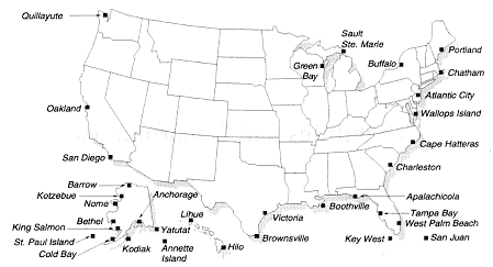
Figure 8.1 Coastal rawinsonde observing network.
continental United States and the Great Lakes, NOAA operates 33 rawinsonde sites (see Figure 8.1) within 10 km of the coast. Rawinsonde observations are made twice a day at the synoptic standard times of 00 UTC and 12 UTC (0700 and 1900 EST), at these stations and others all over the globe. A device with sensors for measuring pressure, temperature, and relative humidity is carried aloft by a gas-filled balloon at about 300 m/min. The device telemeters data back to a receiving station. Wind speed and direction are calculated by tracking the motion of the balloon-borne instrument. The data are normally processed into 6-sec averages of the desired quantities. Observations at specified pressure levels are transmitted to weather services worldwide. NOAA also operates, through the National Data Buoy Center (NDBC), 26 instrumented buoys within 50 km of the coast or Great Lakes shores (Figure 8.2). These are equipped with sensors for pressure, wind, air temperature, and humidity at 3 or 10 m above the sea surface. In addition, sea temperature and wave data are supplied. The buoys report once per hour by satellite. Data retrieval rates are 90 percent for the meteorological sensors and 85 percent for the waves over a 5-year period. Some vigilance by a broad-based user community, from fishing to environmental research, may be necessary to keep buoys in place when their original mission has been served and the sponsor withdraws support. The VOSs report data (pressure, temperatures, humidity, wind, and sea-state and cloud visual observations) at bridge height (about 20 m for modern ships) every 6 hours in the open ocean; within 200 km of land, NOAA requests reports every 3 hours. These disparate data—from different platforms at different times and elevations—are blended into the overall data set by a computerized
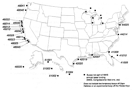
Figure 8.2 U.S. buoy network, September 30, 1991.
objective analysis scheme at NWS. For particular application to the coastal zone, we note that the standard synoptic observing times do not necessarily coincide with maxima or minima in the diurnal sea breeze cycle, and the effects of this bias may be more pronounced in the coastal zone than elsewhere; the lower levels of the balloon soundings do not often resolve the boundary layer and may reflect more of the local urban boundary layer than that over the nearby coast; there are no sounding data over the ocean; usual errors in reported ship positions are more critical than over the open ocean; and coastal ship data are naturally concentrated around ports.
For the future, NOAA's observational equipment modernization will offer some improvements and some degradation of data for the coastal zone. Of the 28 planned WSR-88 Doppler weather surveillance radars, 24 will provide over-water coverage. Reflectivity data (the return from precipitation water in clouds) will be available out to 300 to 400 km offshore; Doppler winds of the radial component will be available out to 150 km. These should result in an improved capability in offshore storm detection, movement, and development. The deployment locations, however, will not result in good coverage off the Pacific Northwest coast. Since there will also be returns from the sea surface as well for low antenna angles, there is the possibility that the "sea clutter" can be interpreted in terms of surface wind and wave data. NOAA's vertical Profiler Demonstration Network of
30 systems will be deployed only in the central and southern United States and therefore will not benefit the coastal zone. Only a few additional coastal NDBC buoy deployments are planned, and these are funded by agencies other than NOAA for specific periods as a part of ongoing experiments. No new upper-air rawinsonde stations are planned, and some coastal stations may be moved several tens of kilometers landward, eliminating real-time observations of the vertical thermodynamic structure within many coastal areas. One such site change, from Boothville to Slidell, Louisiana, has been commented on by Bosart (1990).
Coastal research experiments utilize existing synoptic data sources and, in addition, generally provide specialized observational systems of their own. These range from paying for additional NDBC buoy deployments; building and deploying separate weather buoys by oceanographic institutions (usually as the surface termination of an oceanographic mooring); deploying coastal weather stations to resolve mesoscale processes; using small upper-air balloon systems for soundings in particular locations; using special research aircraft equipped for meteorological measurements; taking meteorological measurements and soundings from ships; and using special satellite products. Coastal experiments usually cover the spatial range from less than 1 km to several hundred kilometers in order to resolve all of the meteorological processes; the experiments generally have an intensive phase of a month or two, sometimes imbedded in longer-term monitoring phases covering a season or more. For long-term coastal ocean studies over larger spatial scales, products such as the "Bakun" winds (Halliwell and Allen, 1984) are sometimes used, which are based on geostrophic winds.
Remote Sensing
Satellite remote sensing products are valuable for the coastal zone; the visual images from the GOES satellites show clearly the large-scale picture and often the sharp differences in cloud cover occurring right at the coast. Kelvin waves propagating up the west coast of the United States were tracked by Dorman (1985) from GOES images of the leading edge of the associated marine stratus cloud. High-quality photos from various manned space missions show dramatic modifications in cloud patterns near coastlines over the world. NOAA passive infrared imagery (e.g., AVHRR) interpreted as sea surface temperature often shows the overall characteristics of coastal oceanographic processes—cold water near the coast during wind-driven upwelling events (Kelly, 1985) and the "squirts and jets" of cold water often found off points and capes (Davis, 1985). For small-scale studies, data from the AVHRR sensors have to be regridded to achieve a spatial accuracy of 1 km. Similarly, the Coastal Zone Color Scanner (CZCS) provides high-resolution maps of plankton concentration. However, the spatial resolution of about
0.8 × 0.8 km is still more suited to the open ocean than the coastal zone. Pulse radars pointing at nadir are used to obtain the topography of the sea surface, from which geostrophic currents can be obtained. Synthetic aperture radar (SAR) has a fine spatial footprint (on the order of 100 m) and often shows complex signatures of the ocean surface, but possible interpretation of surface winds is a research project. Satellite microwave measurements (e.g., the Seasat scatterometer and the DMSP SSM/I) have spatial resolutions that are too coarse to be useful in studies of coastal meteorology.
At this time, the only active sensors in space are the altimeter, scatterometer, and SAR on the European Space Agency's Earth Resources Satellite ERS-1, and the SAR on an Almaz Soviet spacecraft. More are planned for the NASA/CNES TOPEX/POSEIDON mission in 1993, the U.S./Canadian RADARSAT, and the Japanese ADEOS launch in 1995. Passive sensors are on the NOAA series of satellites. The Sea-WIFS (Sea-Viewing Wide Field Sensor), scheduled for launch in 1993, will replace the CZCS with a more sensitive sensor.
Surface-based and space-based systems are complementary. The radar mentioned above is an obvious example of a surface-based system. Geographic coverage is less than from space-based systems, but spatial resolution is often better and thus of importance for the coastal zone. New technology applicable to coastal meteorology includes high-frequency, high-resolution atmospheric boundary layer (ABL) wind profilers; Doppler lidars, which are multichannel microwave radiometers for moisture and temperature profiles; and scanning and millimeter-wavelength radars. These can be based at the coast and pointed over land, over sea, or vertically to map mesoscale features in the coastal zone. In a coastal project Kropfli (1986) used a dual-Doppler radar system, which scattered off aircraft-deployed chaff in the Santa Barbara channel, to resolve an atmospheric eddy in the lee of Point Conception (see Figure 8.3).
The higher-frequency radars (915 MHz; Eklund et al., 1988) are able to backscatter continuously off turbulent refractive index fluctuations in the ABL and so are not restricted to clouds with precipitation or to the use of chaff. A 404-MHz vertically pointing system has been used in the Southern California bight to measure a strong nightly wind jet. With a colocated acoustic sounder to provide temperature profiles, these two systems will be able to map the time-height ABL structure at the coast with unprecedented resolution. Microwave radars have also been used to measure the liquid water content of coastal stratus clouds. Airborne or ground-based lidars can, in principle, provide information on wind, temperature, moisture, aerosols, and trace gases. A lidar was recently used on land in the Monterey, California, area to study the diurnal land-sea breeze; cross sections of the wind speed in Figure 8.4 show the classic land-sea breeze and also reveal complexities of the time evolution and spatial structure. Radar systems can
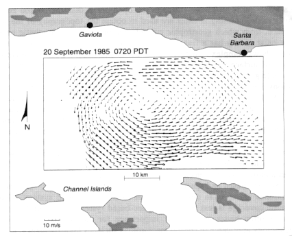
Figure 8.3 Dual-Doppler radar observations with the NOAA/WPL X-band systems in the Santa Barbara Channel using aircraft deployed chaff. A 1-hour composite of horizontal wind vectors in the lower atmospheric boundary layer shows the strong circulation (from Kropfli, 1986).
point at the sea surface and infer surface ocean current and perhaps wave information over mesoscale areas. These would be useful in combined oceanographic/meteorological studies of the coastal zone.
In summary, observations of the coastal zone are a special mix from different systems—land-based NWS synoptic reports, hourly data from coastal buoys, and VOS reports. The data are highly asymmetric; over the coastal ocean there are few surface observations and essentially no balloon soundings. The frequency of some of the observations may not be high enough to resolve important parts of coastal mesoscale processes. Satellite sensors have helped to identify some processes in the coastal zone, but quantitative measurements of important variables in addition to sea surface temperature at the appropriate scales are just beginning. The new WSR-88 radar systems will provide a dramatic increase of weather data off the coasts in storms. Newly developed surface-based remote sensors have the spatial resolution needed for coastal zone studies; they need to be deployed and tested in specialized research experiments to determine the seaward extent
of their measurements. Coastal experiments will undoubtedly continue to deploy additional specialized buoys, sounding systems, research aircraft, ships, and the newer remote systems as they become available.
Two measurement scales appear to be particularly important. Long temporal and large spatial scales provide the framework for more detailed mesoscale process-oriented studies. Low-frequency measurements would depend on buoys capable of measuring atmospheric and oceanographic parameters. Smaller-scale studies would depend on an extensive array of "air-
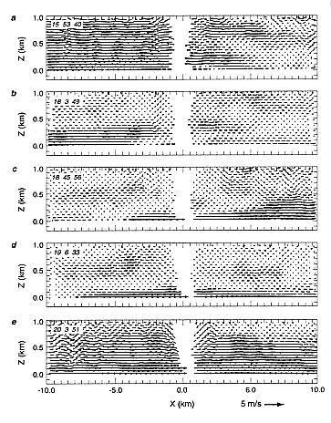
Figure 8.4 Doppler lidar wind vector measurements in a plane perpendicular to the coast near Monterey, California, depicting a 4-hour period in the transition from a land breeze to a sea breeze (sunrise is about 1400 UTCC). The lidar is located at (0,0), 1.5 km inland; Monterey Bay is to the left; and land is to the right (from Olivier et al., 1991).
sea interaction" buoys and moorings, land-based meteorological sites, and in situ measurements with ships and aircraft. The buoys should be capable of making accurate and repeated measurements of sea surface temperature, air temperature, humidity, barometric pressure, wind velocity, solar and long-wave radiation, precipitation, and trace gas concentrations from which fluxes can be estimated. In addition, current and surface wave measurements would be required. Ideally, direct covariance estimates of surface fluxes are needed; however, these remain beyond the reach of present technology for long-term measurements on unmanned platforms.
Reliable, remotely operated instrumentation for atmospheric measurements continues to be a challenge. For example, the ability to determine the depth of the boundary layer and cloud cover from a buoy would provide a significant amount of information about the structure of the atmosphere and the response of the ocean. Understanding the interaction between the atmosphere and the ocean requires an understanding of the structure and the vertical and horizontal variability of the entire atmospheric and oceanic boundary layers. Hitherto, this kind of detailed information has not been available for coastal studies; it would provide a substantial contribution to our understanding of the mesoscale coastal ocean-atmosphere system.
MODELING TECHNOLOGY
Modeling of coastal processes requires the application of physical and numerical simulation tools and analytical studies. The use of physical models related to coastal studies has focused on roughness and heat changes in the near-shore environment as air moves from ocean to land and vice versa. Avissar et al. (1990) have summarized the spatial scales that can be simulated accurately by wind tunnel modeling. One conclusion is that laboratory model studies in coastal environments are inappropriate when the influence of the earth's rotation becomes important. Also, it was shown that coupling meteorological wind tunnel and mesoscale numerical models offers a larger range of conditions than can be simulated by either approach alone. For example, a numerical simulation of a sea breeze can be used to provide the scaled winds and turbulence for input to a detailed wind tunnel simulation of flow around buildings in the coastal environment.
Numerical modeling and analytical modeling have been applied more generally to coastal meteorological studies. Pielke (1984, 1989) reviewed a range of models that have been developed to study mesoscale processes, including land-water interfaces. Zanetti (1990) has summarized air pollution models, including those that are applicable to coastal environments, as well as deficiencies in current regulatory models in this environment. Anthes et al. (1982) review regional models that necessarily include the ocean-continent interface within these simulation tools. To represent the
structure of the coastal environment adequately, high spatial resolution is required. Lyons et al. (1987), for example, have demonstrated for the Kennedy Space Center environment that horizontal grid increments larger than 1 km are unable to realistically simulate strong vertical motions associated with the Indian and Banana rivers. Analytical modeling has helped to clarify understanding of coastal flows. Rotunno (1983) and Dalu and Pielke (1989), for example, have evaluated theoretically the influence of latitude on the propagation characteristics of the sea breeze.
Continued application of these modeling tools is desirable for continued improvement in our understanding of coastal flows and in developing predictive capabilities. Predictability can be defined as the limit in time to which a prediction has skill, as measured, for example, against climatology or persistence. In the context of nonlinear dynamics for a deterministic dissipative dynamic system such as the atmosphere, predictability is limited by the sensitivity to initial conditions (Lorenz, 1963). The sea breeze is an example of a surface-forced coastal feature that results from differential heating of land and water. A coherent wind circulation is due to this well-defined surface heating pattern. One question that needs to be addressed is: How does the predictability of this mesoscale feature change as a function of the spatial size of the differential heating regions, the depth of the convective mixed layer, etc.? A second question is: To what extent are small-scale meteorological features, such as divergence in the wind field phase, locked to coastal topography such as capes in a variety of transitory land-falling storms (e.g., Zemba and Friehe, 1987; Mass and Ferber, 1990)? This "sensitivity to boundary" condition needs to be investigated in the context of nonlinear dynamics.
The emergence of high-performance computer workstations having substantial fractions of the calculation speed and superior throughput of present-day mainframe supercomputers is having an effect on mesoscale research and modeling. These computers allow researchers to run mesoscale models at fine mesh sizes (i.e., time steps) and conduct numerous sensitivity studies. They can also provide effective visualization capabilities and hard disk data storage. These workstations will permit central supercomputers to concentrate on the modeling of the coastal zone that cannot be accomplished at workstations. Recent work (Lyons et al., 1991b) has revealed that sea breeze simulations using nested grid nonhydrostatic models employing very fine inner nests (1000 m or less) produce much sharper frontal discontinuities and consequently stronger vertical motions than do previous coarsermesh runs (see Figure 3.1). When complex shorelines and topography are involved, the resulting simulations become both quantitatively and qualitatively different. Substantial model sensitivity tests need to be conducted to assess how such factors as horizontal and vertical mesh size, as well as characterization of surface heat and moisture fluxes, influence the results.
Data such as that collected during the 1991 Convection and Precipitation/Electrification (CAPE) program will be among the most complete for model sensitivity testing and evaluation. Some present views of coastal mesoscale processes may require revision in light of very fine mesh simulations. The issue of just how fine is fine enough remains open.
Four-dimensional data assimilation (4DDA) issues also need to be addressed. While 4DDA has been used with success at meso-alpha and regional scales, the use of data in coastal zones, where extreme vertical and horizontal gradients are common, raises difficult issues of spatial and temporal representativeness of the data to be used for 4DDA. Pielke et al. (1989) demonstrate the need for increased accuracy in measured data as their spatial separation decreases, showing a general inability to relocate time-space cross sections in the coastal environment. Any new observational system installed in coastal zones, if it is to be useful for potential 4DDA applications, must be carefully designed. If operational coastal models are to become a reality, frequently updated regional soil moisture and vegetation information (from observations not now readily available) will become a requirement. Four-dimensional data assimilation techniques currently being investigated include those typified by Errico and Vukicevic (1991), Hoke and Anthes (1976), and Lipton and Pielke (1986).
The following specific recommendations are made:
-
Site-specific three-dimensional numerical modeling of coastal zones and studies of coastal zone physics may be enhanced by on-site use of high-performance workstations. The development of massively parallel workstations and user-friendly software to increase this performance capability should be encouraged.
-
Standardized procedures to construct subroutines should be developed in order to facilitate the exchange of model components between investigators.
-
The value of ensemble model predictions, as contrasted with a collection of model realizations, needs to be determined. Such evaluations should include the testing of subgrid-scale parameterizations that incorporate a stochastic component in order to ascertain the significance of deviations from an ensemble representation.
-
The extent to which predictability is extended as a result of the spatial structure of the surface forcing needs to be established.
-
Requirements to adequately utilize 4DDA techniques in the coastal environment need to be assessed. Adjoint methods, nudging procedures, and variants of normal model analyses should be tested in the coastal environment where differences in land and water forcing could perhaps be applied to improve the accuracy of data assimilation.


