
7
Sediment Fluxes Along High-Latitude Glaciated Continental Margins: Northeast Canada and Eastern Greenland
JOHN T. ANDREWS
University of Colorado
J. P. M. SYVITSKI
Geological Survey of Canada
ABSTRACT
In the northern hemisphere, glaciated continental margins occur around Greenland, eastern and northern Canada, Norway, Iceland, Spitsbergen, Alaska, and British Columbia, where frequently glaciers and ice sheets terminate(d) at tidewater. The continental shelf may have deep basins parallel to the coast, troughs cut across the shelf, and fiords that extend inland 10 to 100 km from the outer coast. The processes that control the fluxes of sediment to the seafloor during the past deglacial cycle are radically different than those that occurred on continental shelves that lay beyond the limits of glaciation. This is associated with the rate and manner of sediment delivery; the presence of deep basins landward of the shelf break; and a different history of relative sea-level. On time scales of the past 10 ka (ka = 1000 yr), the net flux of sediment to the seafloor can be derived from radiometrically dated cores, or can be modelled. In the eastern Canadian Arctic, the net average net flux to the seafloor varied between 600 and 1300 kg/m2/ka in the outer fiord basins, to about 400 kg/m2/ka in shelf/troughs, to 0 to 50 kg/m2 on the shelf proper. In these fiords, the dominant grain-size delivered to the seafloor is clay, followed by silt and sand. The data suggest that the flux to the seafloor declines exponentially with a "half-distance" of 30 to 40 km. In a large trough off southeast Greenland, the net average flux to the seafloor over the past 8 ka only averaged about 60 kg/m2/ka.
INTRODUCTION
Highly indented fiord coastlines constitute a large proportion of the world's coastline. Fiords (Figure 7.1) are major sediment traps in the terrestrial to deep-sea sediment pathway, and the presence of these basins, landward of the continental shelf, suggests that adjacent shelves and deep-sea basins are presently largely deprived of terrestrial sediment. Based on an estimate of the total volume of later Quaternary (past 100 ka) sediments in fiords, compared to the flux of sediment effluxed from and to the sea during this same interval, fiords have retained 24 percent of the volume of marine sediment deposited over the past 100 ka (Syvitski et al., 1987a, pp. 10-11).
In the past two years, there have been several international symposia on glacial marine sediments and processes, and several major review papers have been published that seek to synthesize our knowledge of these processes and
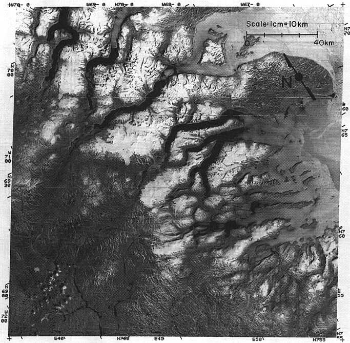
FIGURE 7.1 LANDSAT image of the fiord coast of east Baffin Island, showing the sea ice breaking up (July 22, 1977) and the relatively restricted extent of local ice caps and glaciers.
propose appropriate stratigraphic models (e.g., Andrews and Matsch, 1983; Gilbert, 1983; Molnia, 1983; Elverhoi, 1984; Powell, 1984; Eyles et al., 1985; Dowdeswell, 1987; Powell and Molnia, 1989), yet there is very little information, on a regional scale, of the flux of sediment within the glacial marine environment, especially on time scales of a few thousand years. However, Ruddiman (1977) and Fillon (1985), amongst others, computed the net flux of sand-size particles (ice rafted detritus, IRD) to the North Atlantic deep basins. We confine our discussion, therefore, to areas where we have worked and where such data are available.
This chapter presents data on the flux of sediment to the seafloor along fiord to shelf transects. It thus forms a link between current debates on the efficiency and magnitude of glacial erosion and transfers of sediment to deep sea basins (cf., Laine, 1980; Bell and Laine, 1985; Andrews et al., 1985a). The chapter has two approaches: in the first section we examine the processes that produce sediment along glaciated continental margins and suggest a space-time ranking of these for sediment accumulation. We also examine the climatic and glaciological controls on sediment flux. In the second part, we illustrate some of these aspects by examining two specific regions, the first being the borderland of the eastern Canadian Arctic, fronting Baffin Bay, and the second being part of the East Greenland shelf. The latter area is an analog of the conditions that prevailed in the Canadian Arctic during the last glacial cycle. These areas represent subpolar to polar glaciological environments and contrast (see later) with more active environments in southern Alaska.
OVERALL CONTROLS ON SEDIMENT FLUX
Sediment flux is defined as sediment mass per unit area with respect to time. We normally measure the net flux of sediment to the seafloor, that is kg/m2 per unit time, hereafter termed Fn↓. Consider Figure 7.2 — this shows the direction of sediment fluxes along a fiord to shelf transect. The vertical flux of sediment between two points along this transect is defined as the level of reduced suspended sediment inventory (I in units kg/m2) throughout the water column between these two points. If dI/dt = λI, where λ is a first order removal rate constant, then Ff↓, defined as the net downward flux of sediment can be expressed as Ff↓(x) = Ff0e-λt, where Ff0 is maximum sedimentation rate at the fiord head (Syvitski et al., 1988).
However, we have an additional flux of sediment (Fs↓) being contributed from the shelf (iceberg melting, current resuspension, iceberg ploughing, etc.) and also from local disturbances (F1↓), say between x3 and x4 (Figure 7.2), due to gravity flow deposition which delivers sediment to the fiord basins (Syvitski, 1989). Thus, the net sediment accumulation
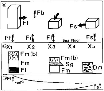
FIGURE 7.2 Diagram illustrating (A) the components in sediment flux along a fiord to shelf transect and (B) the expected sediment types (see text for discussion). The lowermost section (C) schematically shows the expected trends of Ff↓ and Fs↓, which are the trends in sediment flux from the fiord and shelf, respectively.
is the resultant of the three sources plus allochthonous (carbon and silica) deposition, minus losses due to erosion (Fr), so that:
and over some interval of time the total mass of sediment (kg per meter width per unit time) contributed to the sea-floor would be:
In this chapter we ignore the carbon flux to the sea floor because, although it is important, it is usually less than 1 percent dry weight of the sediment (Andrews, 1987a; Syvitski et al., 1989, 1990). A potentially more serious matter is the absence of a measure of the biogenic silica flux, although we know from the work of Williams (1988) that this can be substantial.
Two critical factors become important in determining the amount of suspended sediment that escapes from the fiord to the adjacent shelf: (1) the length of the fluvial plume, and (2) the length of the fiord basin. The plume length is primarily a function of the freshwater discharge but the fiord length is an independent variable. For example, the fiords of southwest Greenland are about twice as long as the northeast Baffin fiords, fluvial input is 2 to
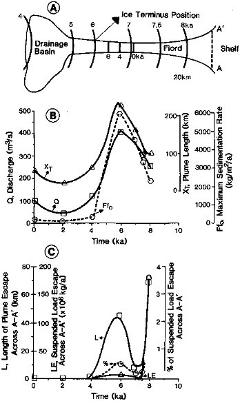
FIGURE 7.3 A. Output from a modeling exercise involving (A) retreat of a fiord glacier through time with a climate equivalent to the eastern seaboard of Baffin Island at present. B. Calculated parameters as a function of time (X T, plume length; Q, discharge; and Ff0, maximum sediment flux). C. The calculated escape of sediment from the fiord to the shelf across profile A-A' (see Figure 7.3A).
5 times larger in southwest Greenland and plume lengths are about twice those observed in Baffin. The net result is that the amount of sediment effluxed from the fiord onto the shelf is about the same in both areas.
Figure 7.3 is a model run (Syvitski et al., 1988) based on the retreat of a tidewater glacier that started 8 kaBP (before present), was subaerial by 6 kaBP, and finally left the drainage basin less than 4 kaBP. Discharge is based on the present climate of northeast Baffin Island (Figure 7.4) with allowance for ice melt and storage during glacial retreat and the Little Ice Age growth and retreat. From these data the plume length (Figure 7.3B) is calculated as is the maximum fiordhead sedimentation rate, Ff0. Figure 7.3C illustrates the length of the plume escaping through section A-A' and the associated volume of sediment (LE) that escapes. Only between 7.5 and 8 kaBP is this escape volumetrically significant, at 3.5 percent of the total fluvial suspended sediment output. Depending on the rate of sediment accumulation, sediment rain-out results in finegrained massive to bioturbated muds (e.g., Hein and Longstaffe, 1985; Syvitski et al., 1989).
The system described on Figure 7.2 results in an exponential decrease in the flux to the seabed along a fiord axis (Elverhoi et al., 1980; Elverhoi, 1984; Pfirman, 1985; Syvitski, 1986; Syvitski et al., 1988). In areas where there is a large number of icebergs drifting along the shelf and into the outer fiords (east Baffin Island and East Greenland) the sediment would coarsen seaward and diamict might be deposited on the shelf because Fn¬ has a significant component of the Fs¬ flux (Figure 7.2)(e.g., Kravitz, 1982). Finally, local debris and mass-movements would result in slumps and/or graded sand beds. Thus, sediment type and
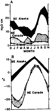
FIGURE 7.4 Climatic range of variables from weather stations along the Baffin Island seaboard compared to climatic data from sites in southeast Alaska (A, precipitation; B, temperature; both monthly averages) in contrasting fiord environments.
the three-dimensional architecture of the basin fills (as portrayed in high resolution seismic profiles) should provide a guide to the processes that resulted in net sediment accumulation at a site (cf., Syvitski, 1989). For example, the difference between draped and ponded sequences indicates a large-scale difference in the dominance of the rain-out of suspended particulates (Ff↓) versus the focusing of sediment into basins through various gravity flow processes (F 1↓) (Figure 7.2).
Processes
The net sediment flux along glaciated coastlines is a function of (1) local bathymetry and topography; (2) regional extent of glacierization; (3) thermal conditions at the bed and surface of the ice (this controls the manner of sediment supply within the ice and the amount of meltwater that is generated); (4) terrestrial and marine climate, including currents; (5) sea ice and iceberg production and spatial extent; (6) sediment and vegetation cover on land; and (7) relative sea-level history. These controls operate differently through space and time with variations forced by the position of the ice front and the history of relative sea-level.
Bathymetry and TopographyFigure 7.5 is a sketch of a glaciated continental borderland, especially those of passive, rifted plate margins. The key bathymetric elements are the fiord basin(s), marginal troughs that lie along geological contacts, and cross troughs that cut across the shelf to the slope. If these were all part of an integrated sediment transport and storage system the cross troughs would head into the fiords; however, as illustrated on Figure 7.6, this is frequently not the case, at least on the shelf fringing east Baffin Island. For example, Figure 7.6 illustrates that the largest fiord in the region is not connected to the adjacent trough. The meaning of this in terms of trough genesis is not clear. The marginal trough (Figure 7.5) is a feature of the
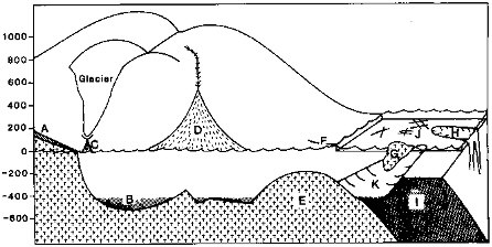
FIGURE 7.5 Schematic sketch of typical features from a fiord head to the adjacent deep-sea basin along a deglaciated coast (NE Canada). A, raised glacial and marine sediment at fiord head; B, basin fill; C and D, coarse fans; E, shield rocks; F, raised beaches and glacial sediments; G, iceberg: H, shelf trough; I, offshore coastal plain sediments; J, iceberg scour marks; K, marginal trough and fill.
Labrador, Norwegian, and West Greenland shelves (Holtedalh, 1958), but they do not occur off Baffin Island. Fiords may or may not have a sill at their mouth (Dowdeswell and Andrews, 1985; Syvitski et al. 1987a) and they can consist of a single basin or several basins. The adjacent continental shelves are often marked by distinct "banks" where water depths are <200 m.
Climate and OceanographyFigure 7.4 illustrates the differences in temperature and precipitation between two contrasting glaciated borderlands — one from the eastern Canadian Arctic and the other from southeast Alaska. The former area is characterized by very cold winters, cool summers with average July temperatures of 5° to 7°C, a mean annual temperature (MAT) of -12°C at sea level,
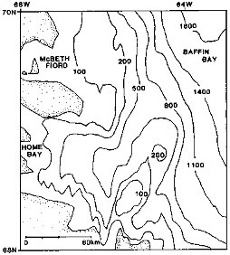
FIGURE 7.6 Bathymetry of the fiord mouths, and shelf in the vicinity of McBeth Fiord, Baffin Island. Note the angle that the shelf troughs make with the fiords. Contours are in meters.
and low annual precipitation receipts of ca. 300 mm. In contrast, the southeast Alaska climate is a cool, wet maritime climate (Figure 7.4). These differences translate into large differences in glaciological regimes, the potential for glacial erosion, and in an order-of-magnitude difference in the volume of meltwater generated by both snow and ice melt (Syvitski et al., 1987a; Powell and Molnia, 1989). An additional major difference between these regimes (Figure 7.4) is that the production of run-off from snow/ice melt and rainfall is restricted to around 90 days in the eastern Canadian Arctic but is potentially year-round in southeast Alaska.
Strong winds are a feature of areas adjacent to ice sheets and glaciers. This, combined with limited vegetation cover, suggests that, in our area of interest, eolian deflation of outwash sediments is a component in highlatitude sediment flux calculations (cf., Gilbert, 1982, 1983; Syvitski and Hein, 1991).
The extent of sea ice (Figure 7.1) and icebergs is extremely different from area to area. The former is related to the air temperature, wind stress, and temperature of the surface layer of the shelf watermass. The size and durability of icebergs is also a matter of air temperature, wind regime, and the character of the source glacier (Dowdeswell and Murray, 1989). Icebergs from fast-moving tidewater glaciers are relatively small, especially compared with the massive icebergs that are produced from outlet glaciers of the Greenland Ice Sheet. A landfast sheet of sea ice during the winter months (Figure 7.1) serves to buffer glacier margins from wave attack, reduces the calving rate, and restricts iceberg passage for several months per year.
Glaciology and Hydrology The critical aspects of glaciology and hydrology for marine sediment flux studies are the mass balance gradient, the thermal conditions at the ice surface and base, the percentage of the basin that is glacierized, and the location and shape of the terminus — does it end in tidewater or on land, and does it have ramp or shelf, or end as a near vertical face? The presence of ice in a drainage basin can extend both the volume of meltwater discharge, by amounts proportional to the area covered by ice, and may also extend the duration of nival and ice associated runoff. However, the origin of sediment carried in the meltwater streams depends on the thermal conditions of the ice body. In temperate areas, with MATs close to 0°C, surface run-off is produced in summer by ablation; this water drains into the glacier and moves toward the ice front in englacial or subglacial conduits. At the base of the glacier, it adds to water already at the bed which has been produced by melting associated with the geothermal heat flux and the frictional heat generated by the ice sliding over its bed. These combined sources result in an annual melt rate at the bed of between <1 mm to several centimeters (Drewry, 1986). By contrast, subpolar environments with MATs << 0°C have meltwater generated on the surface which runs off in supraglacial stream channels on the ice surface. If the supraglacial stream reaches a lateral margin of a glacier it will run along the glacier in a marginal or submarginal drainage channel. Thus, in a temperate glacier, the meltwater reaches the bed of the glacier and can remove fine-grained sediment produced by glacial abrasion and crushing. However, in subpolar glaciers the surface streams are either very clean (if they run over the glacier) or turbid if they can erode sediment along the side of the glacier.
Because of ice convergence into fiords, it is rare to find outlet glaciers reaching the sea that are not at the pressure melting point (PMP) at their beds. Thus, most tidewater glaciers probably discharge water into the sea from basal melt, which rises as a freshwater plume (Pfirman, 1985). Depending on the sediment load, some sediment may be transported via underflows or interflows.
In fiord basins dominated by meltwater there are significant differences between regimes where the fiord is occupied by one or more tidewater glaciers, compared to the situation where the glaciers terminate on land (Syvitski et al., 1988; Syvitski, 1989). In the first situation, sediment deposition is controlled by (1) processes at the ice front (sub-and englacial-meltwater discharge; the flow of supraglacial till, etc.); (2) hemipelagic sedimentation from the fluvial plume; (3) sediment rafting by icebergs and sea ice; and (4) deep-water currents. In contrast, when glaciers end on land, the dominant sediment supplies are from: (1) bedload dumping from the delta front; (2) hemipelagic sedimentation under the seaward flowing river plume; (3) proximal slope bypassing by turbidity currents; and (4) the combined effects of both short- and long-term downslope diffusion of the accreting sediment mass. There is a significant difference in the grain-size distributions between these two cases for the suspended sediment plume (Pfirman, 1985). This is related to the energy loss from a rapidly rising plume (from a subglacial position) compared to the normal fluviodeltaic discharge to the fiord head (Syvitski, 1989). Thus, for a given level of discharge, coarser sediments are deposited closer to the tidewater glacier, whereas equivalent size particles can ride the freshwater surface plume seaward in the fluviodeltaic fiord.
A third glaciological situation exists in true polar climates (i.e., Antarctica), where even in summer no surface melting takes place; basal melting is possible only if the glacier is sliding over its bed.
In the discussion above, we have implicitly assumed that the bulk of glacial sediment is being delivered to the marine environment via meltwater. An alternative delivery system has been proposed, based on theory and limited observation (cf., Boulton and Jones, 1979; Blankenship et al., 1986). This suggests that a glacier may lie on a deformable sediment bed which is transported seaward by
deforming under the ice load. In the Antarctic, where this mechanism has been advocated for a specific ice stream, the deforming sediment is being moved toward the ice front at a rate of >1 km/yr! This process suggests that at the front of fast moving ice streams there may be very large accumulations of ice transported sediment.
Relative Sea-Level History The relative sea-level history against a coast backed by a major continental ice sheet is fundamentally different than that on continental shelves removed from the influence of glacial isostatic depression (e.g., Andrews, 1980; Schlee et al., 1988). This difference is significant in terms of sediment flux. During times of global glaciation, sea-level is lowered by 100 to 120 m on "distant" shelves and the coastal plain sediments are reworked and transported to the shelf edge and beyond (cf., Schlee et al., 1988). In contrast, along glaciated continental margins, relative sea-level was 30 to 100 m higher during glacial advances because of isostatic depression. This resulted in large quantities of coarse outwash and deltaic sediments being stored at fiord and bay-heads (Figure 7.7) as the ice retreats inland (Church, 1972; Church and Ryder, 1972; Syvitski et al., 1987a). However, subsequent isostatic recovery was rapid, and rivers cut into these valley/fiord fills (Figure 7.7) resulting in erosion and recycling of outwash and raised glacial marine sediments.
The Deglacial Sediment Flux Cycle The flux of sediment from glaciated margins to the marine environment is a function of five major processes that vary spatially and temporally through a glacial to interglacial cycle, i.e., the past 10 ka (Figure 7.8). This interval includes the period of "paraglaciation" (Church and Ryder, 1972) which, on land, is characterized by the deposition of massive deltas, fans, and outwash trains, and more recently, the interval "neoglaciation" which is associated with the growth and expansion of valley glaciers and ice sheets. Note that in Figure 7.8, we are considering the simplest possible case — a fiord with no significant sidevalley sediment sources.
On Figure 7.8 we show two major variables; the first is glacier extent; the second is the change in relative sea level. The five major processes that contribute to the net sediment flux are: rain-out of suspended sediment from glacial and snow meltwater; the reworking of deltas and outwash trains because of glacial isostatic recovery (Figure 7.7) (associated with a regional fall in sea level); rafting from icebergs and sea ice and associated ploughing and disturbance of sediment by reworking (e.g., MacLean, 1985; Josenhans et al., 1986; Praeg et al., 1986; Barnes and Lien, 1988; Pereira et al., 1988); eolian transport (Gilbert, 1982, 1983); and turbidites and debris flows. These processes changed in intensity through the last deglacial cycle (Figure 7.8). The figures on the axes of the sediment processes (10, 1, etc.) represent order of magnitude estimates of the importance of the process to the net Fn↓.
An additional factor that is hard to forecast is the effect of earthquakes on sediments. The northeast shelf of Baffin Island is in a high seismicity zone (Adams and Basham, 1989); high magnitude events (for example, the M7.3 event in 1933) could well trigger large slumps and slides throughout the fiord/shelf system.
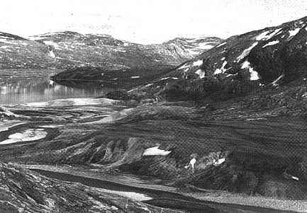
FIGURE 7.7 Photograph of raised glacial marine sediments that have been eroded by river incision associated with 60 m of glacial isostatic rebound (Home Bay, east Baffin Island) over the past 6 to 8 ka.
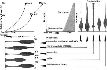
FIGURE 7.8 Sketches of some of the major processes affecting sedimentation along continental glaciated margins such as NE Canada, Greenland, and W. Norway. The rate of sedimentation associated with each is shown in a relative sense versus time and distance from the major sediment source.
DEGLACIAL TO INTERGLACIAL FIORD/SHELF SEDIMENT FLUX
In this section we examine data from the fiords and shelf of the eastern Canadian Arctic (Figures 7.1 and 7.4) and off East Greenland (Figure 7.9) as being broadly representative of both rates and processes in subpolar, arctic conditions. Fluxes in Alaskan fiords are significantly higher (Molnia, 1983; Powell, 1983; Powell and Molnia, 1989).
East Baffin Island
One of the objectives of the Canadian Sedimentology of Arctic Fjords Experiment (SAFE) (Syvitski and Schafer, 1985) was to provide information on modern and late Quaternary sediment processes and fluxes. The various sediment types, or facies, associated with these processes (Figure 7.2) have been identified by Gilbert (1983), Hein and Longstaffe (1985), Syvitski et al. (1987b), and Eyles et al. (1987), among others. The occurrence of different facies within the fiords, and on the shelf, can be evaluated by a combination of an analysis of high resolution, deep tow seismics (DTS) (e.g., Figure 7.10), and piston coring.
Figure 7.11 shows how the distribution of glaciers and mountains (cf., Figure 7.1) influence the flux of water and sediment from the land to Itirbiling Fiord. The annual present sediment flux into the fiord is estimated at 3.35 million tonnes, of which 83.7 percent is in the form of bedload, 10.7 percent is through eolian transport, and only 5.6 percent is fluvially delivered suspended load (Syvitski, unpubl.). In the inner basin, sedimentation is dominated by gravity flows that are initiated from failure of the delta front, whereas the distal basins are affected by hemipelagic
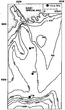
FIGURE 7.9 Map of shelf and trough off East Greenland. Core location is shown and discussed in the text. Contours are in meters.
sedimentation of suspended load, eolian sands and silts that have not been scavenged from the surface plumes, and intermittent delivery of mixed grain-size sediments from the melting of icebergs and sea ice. Sediment traps moored in 50 m of water and 0.5 km from the head of Itirbilung Fiord (Figure 7.11) for 39 days in mid- to late summer,
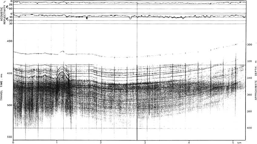
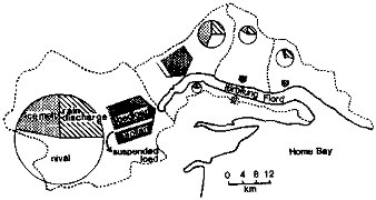
FIGURE 7.11 Itirbilung Fiord, eastern Baffin Island, showing estimated contributions of runoff into the fiord from the different drainage basins and sediment contribution to the fiord.
1985, collected sediment at a rate of 1.2 kg/m2 per day; if we assume this rate applies for a 90-day period, then the ''annual" accumulation in the inner basin is 110 kg/m2.
These estimates (Figure 7.11) reflect current conditions and a fiord dominated by fluvial discharge. However, at 8 to 10 kaBP the fiords of eastern Baffin Island contained large tidewater glaciers and the transition from tidewater to terrestrial glaciers probably occurred ca. 7 kaBP (Andrews, 1990)(see also Figure 7.3A).
In order to determine sediment flux we need information on (1) sediment bulk density, and (2) numeric ages at different levels in cores. The first requirement has been met by on-board sampling of sediment in 10 cm Lehigh cores (1 to 3 m length) (Reasoner and Hein, 1984), or by determinations on the piston cores. In the latter we have worked on material specifically sampled for mass physical properties and, in addition, we used sediment collected in 3.15 cc paleomagnetic boxes (cf., Andrews et al., 1986; Andrews and Jennings, 1987) to derive wet volume density (Figure 7.12), which was then converted to dry volume density estimates (Figure 7.13). The second requirement is not trivial because the majority of cores from the fiords lacked calcareous foraminifera, so we are unable to date the cores by the accelerator mass spectrometry (AMS) radiocarbon method on 2 to 4 mg samples of hand-picked foraminifera (cf., Andrews et al., 1989a). We had to rely on AMS dates on the acid-insoluble organic matter (AIOM) fraction. We knew from experiments (Andrews et al., 1985b) that these dates were too old; however, a statistical relationship did exist between paired dates on shells and the AIOM fraction. We have used this correction and investigated its applicability by analysis of the geomagnetic secular variations (Andrews et al., 1986) of piston cores. The results indicated that the corrected 14C dates provided a "reasonable" chronology from 7 to 12 ka. This conclusion was also supported by the pollen and dinoflagellate biostratigraphy (Short et al., 1989). The raw dates and further discussions are included in Jennings (1986), Andrews (1987b; 1990), and Andrews et al. (1989a).
Most cores have three 14C dates that cover the past 10 ka, hence we feel it is most appropriate to consider the sediment flux in appropriate 2 to 5 ka time-slices. Analysis of the contributions of the various measurement errors to errors in estimation indicates that the 95 percent confidence limit in estimating the sediment accumulation (age ± 20 percent and dry volume density ± 10 percent) is ± 14 percent, and no worse than ± 20 percent (Taylor, 1982).
On Figure 7.14 we show a generalized profile for McBeth and Itirbilung fiords (Figure 7.1) and the Fn↓ of sediment in the fiord to shelf transects. The data have been divided into four intervals, i.e., the past 10 ka, and then the periods between 8 to 10 kaBP (the glacial/deglacial transition), 5 to 8 kaBP (paraglaciation, i.e., massive meltwater delivery), and 0 to 5 kaBP (neoglaciation). These broad intervals are appropriate given the number of dates per core (about 3) and the problems in radiocarbon dating.
We are now in a position to discuss changes in categories of Fn↓; that is, we can convert percentage data on grain size—clay- and silt-size mineralogy (Andrews et al., 1989b)—into fluxes and examine variations during the last deglacial cycle. A critical question is: Can we differentiate the sediment sources by considering changes in specific grain-size, mineral suite, or sediment type?
There are few data on the grain-size characteristics of suspended sediment in glacier meltwater (e.g., Church and Gilbert, 1975; Pfirman, 1985; Gurnell and Clark, 1987; Syvitski et al., 1987b) but an indicator of glacial meltwater activity may be the percentage of coarse silt (Figure 7.15), although this can be influenced by a number of other factors. Coarse silt percentages vary between ca. 2 and 25 percent; there is a consistent difference in the coarse silt seafloor flux between McBeth and Itirbilung fiords (Figure 7.15), although the amount of coarse silt in IT3.1 is markedly different from all other cores. The sample interval employed for the grainsize data on Figure 7.15 is too coarse to be a measure of glacial meltwater variations on a 100-year interval.
Several studies have shown that detrital carbonate is significantly higher on the shelf than in the fiords (Jennings, 1986; Andrews et al., 1989b) and that this reflects the transport of ice eroded sediment from Paleozoic basins in northwest Greenland and the high Canadian Arctic. Carbonates are absent within the fiords and detrital carbonate may reflect a shelf → fiord sediment transfer (e.g., Jennings, 1986; Andrews et al., 1989).
The 100-km transect from McBeth Fiord (Figure 7.14) includes the outer basin and adjoining shelf. Four cores are available (Table 7.1); the shelf core (HU78-36) has a basal date on shell of 11,770 ± 550 yr (GX-6280) and appears to
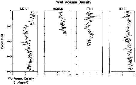
FIGURE 7.12 Downcore variations in wet volume density for fiord cores in McBeth and Itirbilung fiords (see Table 7.1 and Figure 7.1).
have a complete Holocene foraminifera record, although net loss of sediment at times is inferred (Osterman and Nelson, 1989). The fiord head is located 80 km from core HU83-MC4.1 (Figure 7.14). The net total flux of sediment to the seafloor over the past 10 ka varied between 5900 and 950 kg/m2 with an approximate "half-distance" of 30 km. The Fn↓ of sand increased between MC4.1 and MC83.6 perhaps suggesting that the sand in the latter core must be derived from the shelf or local sources. During the local glacial/interglacial transition, between 10 and 8 ka. the Fn↓ at the most ice proximal site, MC4.1, was 1500 kg/m2 and 1000 kg/m2 at MC83.6. Clay-size sediment was the major size fraction at MC4.1, whereas at MC83.6 the sediment was about equal in terms of sand/silt/clay. During the next 3 ka, the Laurentide Ice Sheet was melting rapidly across the eastern Canadian Arctic (cf., Dyke, 1974; Dyke and Prest, 1987) and glaciers retreated to the fiord heads and beyond. The fiord to shelf sediment flux gradient of Fn↓ increased so that the accumulation of 1900 kg/m2 at MC4.1, and 1500 kg/m2 at MC7, is matched by only 480 kg/m2 at MC83.6 (Figure 7.14). Little sand, relative to other sizes, was reaching the seafloor during this period at any site. Finally, local mountain glaciers expanded during the past 5 ka, the so-called "neoglaciation" (Andrews, 1982; Davis, 1985); the supply of sand at MC4.1 shows a dramatic increase (Figure 7.14), which probably represents the input of sediment from local glaciers and glacial fluvial runoff (Andrews, 1990).
The Itirbilung Fiord transect (Figures 7.11 and 7.14) includes a core 20 km from the fiord head and two near the fiord mouth. There is no adjacent shelf core for comparisons although HU78-37 from a trough, just to the south, provides some data (Andrews, 1987b). At HU83-IT2.3, the Fn↓ at the site over the past 10 ka is 8300 kg/m2; this is similar to the accumulation of sediment at IT1.1 over the past 4 to 5 ka (Figure 7.14). Even so, the seafloor sediment flux at IT1.1 is a factor of 4 lower than that recorded at the sediment trap, some 20 km closer to the delta front.
During neoglaciation the Fn↓ at IT2.3 amounted to 2750 kg/m2, comparable to the accumulation at MC4.1 (Figure 7.14). A comparison of IT1.1 and IT2.1 over the past 5 ka indicates that the absolute amount of sand reaching the seafloor declined seaward as did the silt-size material; thus, the sediment became more clay-rich down fiord. The accumulation in the shelf trough at HU78-37 totalled ca. 6000 kg/m 2 for the past 10 ka and 1900 kg/m2 for the past 5 ka. This is substantially more than at site HU78-36 and indicates a significant difference in Fn↓ between the shelf proper and troughs/basins within the shelf. An estimate of Tn↓ for the outer McBeth basins and shelf for the past 10 ka is approximately 120 and 106 kg per meter width (Figure 7.14).
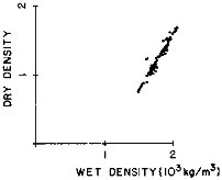
FIGURE 7.13 Relationship between wet and dry volume density determinations on samples from three fiord cores from Baffin Island, NWT, fiords.
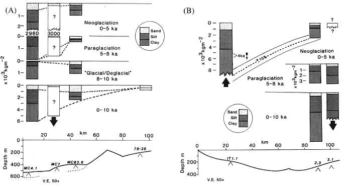
FIGURE 7.14 (A) Diagram of sediment flux variations along McBeth Fiord. The numbers along the profile (Figure 7.14B, e.g., MC7) refer to the number of the core (Table 7.1). Silt and clay content not known for MC7, hence the question mark. (B) Similar data also shown for Itirbilung Fiord. Both profiles start about 70 to 80 km from the respective fiord heads.
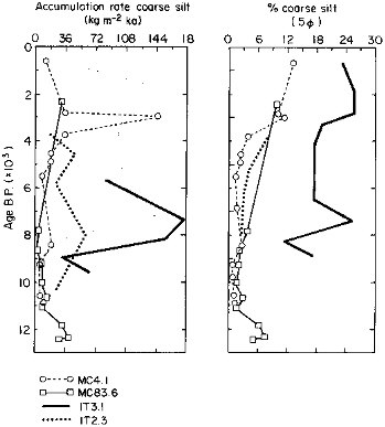
FIGURE 7.15 Downcore variations in the percentage of coarse silt in the <2 mm matrix (right), and the net seafloor flux of this grainsize per 100 yr (left). Core locations are given in Table 7.1.
Southwest Greenland today might be an analog for the Baffin Island region some 8 ka ago. Herman et al. (1972) reported that cores from two fiords in front of the ice sheet had about 12 m of accumulation in 5.5 ka. Although sediment densities were not reported, the sediment flux is probably of the order of about 1600 kg/m2/ka, a figure similar to that observed in the outer Baffin Island fiord basins during deglaciation (Figure 7.14).
Representative Fn↓'s for clay-size materials over the past 10 ka are shown as Figure 7.16 for fiord, shelf, and the ODP 645 site in Baffin Bay (cf., Srivastava et al., 1987). The net accumulation of clay-size particles over this interval varies from ca. 4600 in the outer fiords, to 2600 in the shelf troughs, and 1000 kg/m2 in Baffin Bay. The clay-size mineralogy of samples from all three environments (Andrews et al., 1989b) was studied via standard x-ray diffraction techniques. The dominant clay-mineral species is illite/mica and the net Fn↓ of this mineral decreases dramatically from the fiords to the deep sea, with values over 10 ka of 3800, 1700, and 480 kg/m 2, respectively. Quartz and feldspars show much less variation and approximately equal amounts reached the seafloor in the deep sea and shelf troughs. Detrital carbonate, mainly dolomite but with some calcite (Andrews et al., 1989b), reached a peak Fn↓ of ca. 250 kg/m 2 on the shelf with
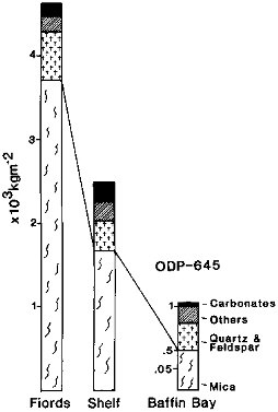
FIGURE 7.16 Seafloor flux Fn↓ of clay-size particles and clay-size mineralogy of fiord, shelf, and deep-sea sediments (Baffin Island to Baffin Bay).
lesser amounts in the fiords and deep sea. These data suggest that the carbonate was brought into the area via the Baffinland Current, probably in the form of both suspended particulates, from meltwater, and as material contained in icebergs.
Figure 7.17 presents a summary (Andrews, 1987b) for fiord to deep sea Fn↓ over the past 8 ka. These data do not include the sites on Figure 7.14, however, they also suggest that the Fn↓ decreases by about one-half over a distance of 30 to 40 km (see Figure 7.14).
It must be emphasized that this study considers Fn↓ along a narrow strip of the seafloor. Flux calculations, from cores, can be partly checked by the geometries of the acoustic reflectors (Figure 7.10), however, this only provides a two dimensional view of the sediment architecture (e.g., Gilbert, 1985). To be fully representative, so that we can make volume calculations for entire systems, we require cross-fiord and cross-trough seismic stratigraphies.
The East Greenland Margin
Kangderlugssuaq Fiord is a deep re-entry into the heavily glaciated margin of East Greenland. Seaward from the fiord a deep trough (Figure 7.9) cuts across the shelf. In 1988, a WHOI cruise collected a suite of 10-cm diameter gravity cores (1 to 2 m in length) from the trough floor and shelf. Three cores were shipped to the University of Colorado for study (Figure 7.9; Table 7.1). Wet and dry volume densities were measured and a series of basal core dates were obtained on hand-picked foraminifera. Our objective in this ONR supported study was to examine the fiord to deep-sea sediment flux.
The sediments in cores 5A and 10A were principally massive to laminated muds with some dropstones. The lowermost 4 cm in core 10A is a diamict. In deeper water on the slope, the sediment in core 17B was a diamict. Prior to this work we know of no radiocarbon dates from the East Greenland Shelf, although some may exist.
The stonyness of core 17B precluded precise measurements of the dry volume density, but in the other two cores (5A and 10A) it was surprisingly low, with medians of 690 and 860 kg/m3. The AMS basal dates and their depths in the cores (Table 7.2) imply average sediment fluxes during much of the Holocene of 60 kg/m2/ka and 67 kg/m2/ka at sites 5A and 10A, respectively. These initial results give fluxes that are an order of magnitude less than the trough cores we have from the eastern Canadian Arctic shelf (Jennings, 1986; Andrews, 1987b; this chapter). At this stage these results are intriguing but need a wider regional context before their value can be adequately assessed; this will come from work on other cores collected during the cruise, plus planned future work on the shelf and in the adjacent fiords. Additional AMS14C dates, processed for the core tops, indicate continuous sedimentation to be present.
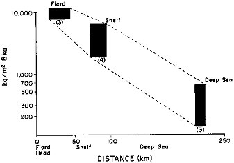
FIGURE 7.17 Sediment flux over the past 8 ka from Baffin Island fiord sites, to shelf-trough sites, to Baffin Bay (from Andrews, 1987b). The numbers in brackets refer to the number of cores used in establishing the range of estimates.
TABLE 7.1 Information on the Cores
|
Core # |
Latitude |
Longitude |
Water Depth, m |
Core Penetration (A) |
Core Length (B) |
Ratio B/A |
|
78-36 |
70°0.8.09’ |
66°48.07’ |
99 |
NA |
99 |
NA |
|
MC83.6 |
69°40.7’ |
69°09.8’ |
429 |
450 |
306 |
0.68 |
|
MC7 |
69°37.5’ |
69°16’ |
497 |
NA |
1121 |
NA |
|
MC4.1 |
69°31.4’ |
69°57’ |
549 |
810 |
610 |
0.75 |
|
IT3.1 |
69°17.6’ |
68°12.3’ |
365 |
810 |
483 |
0.6 |
|
IT2.3 |
69°17.5’ |
68°12.3’ |
410 |
853 |
610 |
0.72 |
|
IT1.1 |
69°20’ |
69°03.8’ |
256 |
900 |
793 |
0.88 |
|
78-37 |
68°15.05’ |
65°12.09’ |
457 |
NA |
593 |
NA |
|
East Greenland |
|
|
|
|
|
|
|
5A |
67°05.9’ |
30°54.5’ |
707 |
NA |
76 |
NA |
|
10A |
65°12.5 |
30°39.5’ |
496 |
NA |
103 |
NA |
|
17B |
65°19.0’ |
30°59.9’ |
997 |
NA |
83 |
NA |
TABLE 7.2 Radiocarbon Dates from the East Greenland Shelf
|
Core # |
Depth, m |
Laboratory # |
Age and Error, yr |
|
5A |
0.73 to 0.75 |
AA-3976 |
9865 ± 110 |
|
10A |
110.5 to 102.5 |
AA-4026 |
13585 ± 110 |
|
17B |
0.77 to 0.81 |
AA-4027 |
8755 ± 80 |
CONCLUSIONS
Sediment flux estimates on glacial to interglacial time scales from glaciated continental margins are rare and more studies are required in such areas as Greenland, Spitsbergen, Canada, and Alaska. The sediment flux has contributions from several sources (in a process sense) (Figures 7.2 and 7.8), and distinctions between them in terms of the sediment type are not always obvious. In addition to these different sources, most continental margins have at least a local and a regional sediment provenance—these may be distinguished in some areas on the basis of mineralogies of the different grain-size fractions and/or on the sediment type (Figure 7.16). The most significant scientific obstacle to such studies will continue to be the acquisition of reliable 14C dates. Studies on these time scales should be supplemented, whenever possible, with the deployment of sediment traps to study the nature of the present sediment flux over a period of 1 to 3 years.
In the middle arctic area of western Baffin Bay, on a deglacial/interglacial time scale, the net downward flux of sediment in Baffin Island outer fiord basins is of the order of 600 to 800 kg/m2/ka, compared with 200 to 300 kg/m2/ka in the adjacent shelf-troughs (Figure 7.13; Andrews, 1987b). The half-distance for the net accumulation may be of the order of 30 to 40 km. X-radiography and paleomagnetic studies indicate that the dominant sediment flux is associated with the rain-out of sediment from sediment plumes. Preliminary data from an East Greenland shelf-trough gives net accumulation rates of only ca. 60 to 80 kg/m 2/ka, suggesting that (1) little sediment is escaping from the fiords, (2) little sediment is being produced, or (3) most of the sediment is bypassing the trough en route to the deep sea. However, we stress that there is significant spatial and temporal variability in sediment fluxes adjacent to continental glacial margins and, at the moment, generalizations should be made with care.
The sediment flux data reported on in this chapter are largely derived from a number of different sources. There is a critical need to undertake one or more specific transects from fiords out to the adjacent deep sea basins with the intent of studying the sediment flux. If such studies could be combined with long-term sediment trap data then it would be possible to evaluate present and past sediment fluxes along glaciated continental margins. The underlying requirement in all such studies will be availability of accurate and precise 14C age measurements. Rather than the current number of about 3 dates per 10 ka, one date per 1 ka is required to fully evaluate Fn↓ on glacial to present time scales. In addition, or supplemental to this approach, is the inverse but nonlinear relationship between sediment accumulation and organic carbon content (Andrews, 1987b; Syvitski et al., 1990)—this might allow fine-tuning of sediment accumulation records.
An important requirement is to continue to improve and enhance computer simulations of sediment fluxes (see Figure 7.3) and to integrate them with well designed field experiments, involving sediment trap data, high resolution seismic data (Figure 7.10), and long (20 to 50 m) piston cores.
ACKNOWLEDGMENTS
This work has been supported by grants from the Office of Naval Research (ONR-0001487K0026 and ONR-N000148J1013) and the National Science Foundation (DPP-83-06581). The cores from east Baffin Island were collected by the Atlantic Geoscience Center, Dartmouth, Canada, and thanks are extended to their personnel for assistance and advice. The cores from East Greenland were collected as part of a WHOI cruise, supervised by Dr. John Milliman. Radiocarbon dating has been carried out with the co-operation of the NSF national AMS facility at the University of Arizona where Dr. A.J.T. Jull has been most cooperative in arranging for the timely dating of critical samples. Discussions with several individuals at INSTAAR have been critical, and I am especially indebted to Dr. K. Williams and Anne Jennings. R. Kihl did a superb job on the grain-size and other sedimentological measurements. The chapter has benefitted from the comments of Dr. J.H. Kravitz, and constructive reviews by Drs. R. Gilbert and B. Molnia. This is SAFE Contribution No. 31 and Geological Survey of Canada Contribution No. 35689.
REFERENCES
Adams, J., and P. Basham (1989). The seismicity and seismotectonics of Canada east of the Cordillera, Geoscience Canada 16, 3-16.
Andrews, J.T. (1980). Progress in relative sea level and ice sheet reconstructions Baffin Island, N.W.T. for the past 125,000 years, in Earth Rheology, Isostasy, and Eustasy, N.A. Morner, ed., John Wiley, New York, pp. 175-200.
Andrews, J.T. (1982). Holocene glacier variations in the Eastern Canadian Arctic, Striae 18, 9-14.
Andrews, J.T. (1987a). Downcore variations in the carbon content of fiord piston cores and association with sedimentation rates, in Sedimentology of Arctic Fjords Experiment: Data Report 3, J.P.M. Syvitski and D.B. Prage, compilers, Canadian Data Report of Hydrography and Ocean Sciences 54, Ch. 12, 19 pp.
Andrews, J.T. (1987b). Late Quaternary marine sediment accumulation in fiord-shelf-deep transects, Baffin Island to Baffin Bay, Quaternary Science Reviews 6, 231-243.
Andrews, J.T. (1990). Fiord to deep-sea sediment transfers along the Northeastern Canadian continental margin: Models and data, Geographie Physique et Quaternaire 44, 55-70.
Andrews, J.T., and A.E. Jennings (1987). Influence of sediment source and type on the magnetic susceptibility of fiord and shelf deposits, Baffin Island and Baffin Bay, N.W.T., Canadian Journal of Earth Sciences 24, 1386-1401.
Andrews, J.T., and C.L. Matsch (1983). Glacial Marine Sediments and Sedimentation: An Annotated Bibliography, Geobooks Ltd., Norwich, U.K., 227 pp.
Andrews, J.T., P.U. Clark, and J.A. Stravers (1985a). The patterns of glacial erosion across the eastern Canadian Arctic, in Quaternary Environments: Baffin Island, Baffin Bay and West Greenland, J.T. Andrews, ed., Allen and Unwin, Boston, pp. 69-92.
Andrews, J.T., A.J.T. Jull, D.J. Donahue, S.K. Short, and L. E. Osterman (1985b). Sedimentation rates in Baffin Island fiord cores from comparative radiocarbon dates, Canadian Journal of Earth Sciences 22, 1827-1834.
Andrews, J.T., J.S. Mothersill, and A. Tabrez (1986). Paleomagnetic record, texture, and mineralogy of Late Quaternary fiord sediments, Baffin Island, Arctic and Alpine Research 18, 361-376.
Andrews, J.T., C.A. Laymon, and W.M. Briggs (1989a). Radiocarbon Date List VI, Baffin Island and III Labrador-Ungava, University of Colorado, Boulder, INSTAAR Occasional Paper No. 46, 85 pp.
Andrews, J.T., A. Geirsdottir, and A.E. Jennings (1989b). Spatial and temporal variations in clay- and silt-size mineralogies of shelf and fiord cores, Baffin Island, Continental Shelf Research 9, 445-463.
Barnes, P.W., and R. Lien (1988). Icebergs rework shelf sediments to 500 m off Antarctica, Geology 16, 1130-1133.
Bell, M., and E.P. Laine (1985). Erosion of the Laurentide Ice Sheet by glacial and glaciofluvial processes, Quaternary Research 23, 154-174.
Blankenship, D.D., S.T. Rooney, R.B. Alley, and C.R. Bentley (1986). Seismic evidence for a deforming and eroding till beneath an active Antarctic ice stream, EOS 67, 946.
Boulton, G.S., and A.S. Jones (1979). Stability of temperate ice caps and ice sheets resting on beds of deformable sediment, Journal of Glaciology 24, 29-43.
Church, M. (1972). Baffin Island sandurs: A study of arctic fluvial processes, Geological Survey of Canada Bulletin 216, 208 pp.
Church, M., and R. Gilbert (1975). Proglacial fluvial and lacustrine environments, in Glaciofluvial and Glaciolacustrine Sedimentation, A.V. Jopling and B.C. McDonald, eds., Special Publication 23, Society of Economic Paleontologists and Mineralogists, pp. 22-100.
Church, M., and J.M. Ryder (1972). Paraglacial sedimentation: A consideration of fluvial processes conditioned by glaciation, Geological Society of America Bulletin 83, 3059-3072.
Davis, P.T. (1985). Neoglacial moraines on Baffin Island, in Quaternary Environments: Eastern Canadian Arctic, Baffin Bay and Western Greenland, J.T. Andrews, ed., Allen and Unwin, Ondon, pp. 682-718.
Dowdeswell, J.A. (1987). The processes of glaciomarine sedimentation, Progress in Physical Geography 11, 52-90.
Dowdeswell, E.K., and J.T. Andrews (1985). The fiords of Baffin Island: Description and classification, in Quaternary Environments: Eastern Canadian Arctic, Baffin Bay and Western Greenland, J. Andrews, ed., Allen and Unwin, London, pp. 682-718.
Dowdeswell, J.A., and T. Murray (1989). Modeling rates of sedimentation from icebergs (abstract), Glaciomarine Environments: Processes and Sediments, Geological Society of London.
Drewry, D. (1986). Glacial Geologic Processes, Edward Arnold, London, 276 pp.
Dyke, A.S. (1974). Deglacial chronology and uplift history: Northeastern sector, Laurentide Ice Sheet, Occasional Paper No. 12, INSTAAR, University of Colorado, Boulder, 73 pp.
Dyke, A.S., and V.K. Prest (1987). Late Wisconsin and Holocene history of the Laurentide Ice Sheet, Geographie Physique et Quaternaire XLI, 237-264.
Elverhoi, A. (1984). Glaciogenic and associated marine sediments in the Weddell Sea, fjords of Spitsbergen and the Barents Sea: A review, Marine Geology 57, 53-88.
Elverhoi, A., O. Liestol, and J. Nagy (1980). Glacial erosion, sedimentation and microfauna in the inner part of Kongsfjorden, Spitsbergen, Norsk Polarinstitutt Skrifter 172, 33-61.
Eyles, C.H., N. Eyles, and A.D. Miall (1985). Models of glaciomarine sedimentation and their application to the interpretation of ancient glacial sequences, Palaeogeography, Palaeoclimatology, Palaeoecology 51, 15-84.
Eyles, N., T.E. Day, and A. Gavican (1987). Depositional controls on the magnetic characteristics of lodgement tills and other glacial diamict facies, Canadian Journal of Earth Sciences 24, 2436-2458.
Fillon, R.H. (1985). Northwest Labrador Sea stratigraphy, sand input and paleoceanography during the last 160,000 years, in Quaternary Environments: Eastern Canadian Arctic, Baffin Bay and Western Greenland, J.T. Andrews, ed., Allen and Unwin, London, pp. 210-247.
Gilbert, R. (1982). Contemporary sedimentary environments on Baffin Island, N.W.T., Canada, Glaciomarine processes in fiords of eastern Cumberland Peninsula, Arctic and Alpine Res. 14, 1-12.
Gilbert, R. (1983). Sedimentary processes of Canadian Arctic fiords, Sedimentary Geology 36, 147-175.
Gilbert, R. (1985). Quaternary glaciomarine sedimentation interpreted from seismic surveys of fiords on Baffin Island, N.W.T., Arctic 38, 271-280.
Gurnell, A.M., and M.J. Clark (eds.) (1987). Glacio-Fluvial Sediment Transfer, An Alpine Perspective, John Wiley & Sons, New York, 524 pp.
Hein, F.J., and F.J. Lonstaffe (1985). Sedimentologic, mineralogic, and geotechnical descriptions of fine-grained slope and basin deposits, Baffin Island fiords, Geo-Marine Letters 5, 11-16.
Herman, Y., J.R. O'Neill, and C.L. Drake (1972). Micropaleontology and paleotemperatures of postglacial SW Greenland fjord cores, Acta Universitatis Ouluensis, Series A, Geologica No. 1, University of Oulu, 357-407.
Holtedahl, H. (1958). Some remarks on the geomorphology of continental shelves off Norway, Labrador, and southeast Alaska, Journal of Geology 66, 461-471.
Jennings, A.E. (1986). Late Quaternary marine sediments from a transect of fiord and continental shelf environments: A study of piston cores from Clark Fiord and Scott Trough, Baffin Island, M.S. thesis, University of Colorado, Boulder, 245 pp.
Josenhans, H.W., J. Zevenhuizen, and R.A. Klassen (1986). The Quaternary geology of the Labrador Shelf, Canadian Journal of Earth Sciences 23, 1190-1214.
Kravitz, J.H. (1982). Sediments and sediment processes in Kane Basin, a high arctic glacial marine basin, INSTAAR Occasional Paper 39, University of Colorado, Boulder, 184 pp.
Laine, E.P. (1980). New evidence from beneath the western North Atlantic for the depth of glacial erosion in Greenland -nd North America, Quaternary Research 14, 188-198.
MacLean, B. (1985). Geology of the Baffin Island shelf, in Quaternary Environments: Eastern Canadian Arctic, Baffin Bay, and Western Greenland, J.T. Andrews, ed., Allen and Unwin, London, pp. 154-177.
Molnia, B.F., ed. (1983). Glacial-Marine Sedimentation, Plenum, New York.
Osterman, L.E., and A.R. Nelson (1989). Latest Quaternary and Holocene oceanography of the eastern Baffin Island continental shelf, Canada: Benthic foraminiferal evidence, Canadian Journal of Earth Sciences 26, 2236-2248.
Pereira, C.P.G., C.M.T. Woodworth-Lynas, and J.V. Barrie (1988). Iceberg scour investigations and sedimentology of the Southeast Baffin Island Continental Shelf, Arctic 41, 221-230.
Pfirman, S.L. (1985). Modern sedimentation in the Northern Barents Sea: Input, dispersal and deposition of suspended sediments from glacial meltwater, Woods Hole Oceanographic Institution 85-4 (Doctoral Dissertation), Woods Hole, MA., 376 pp.
Powell, R.D. (1983). Glacial-marine sedimentation processes and lithofacies of temperate glaciers, Glacier Bay, Alaska, in Glacial-Marine Sedimentation, B.F. Molnia, ed., Plenum, New York, pp. 185-232.
Powell, R.D. (1984). Glaciomarine processes and inductive lithofacies modeling of ice shelf and tidewater glacier sediments based on Quaternary examples, Marine Geology 57, 1-52.
Powell, R.D., and B.F. Molnia (1989). Glaciomarine sedimentary processes, facies, and morphology of the south-southeast Alaska shelf and fjords, Marine Geology 85, 359-390.
Praeg, D.B., B. MacLean, I.A. Hardy, and P.J. Mudie (1986). Quaternary geology of the southeast Baffin Island continental shelf, Geological Survey of Canada Paper 85-14, 13 pp. (with maps).
Reasoner, M.A., and F.J. Hein (1984). Sedimentology and geotechnical properties of surficial bottom sediments, Baffin Island fjords, in Sedimentology of Arctic Fjords Experiment: HU 83-028 Data Report, Volume 2, J.P.M. Syvitski, compiler, Canadian Data Reports on Hydrography and Ocean Science No. 28, Chapter 11, 111 pp.
Ruddiman, W.F. (1977). Late Quaternary deposition of ice-rafted sand in the subpolar North Atlantic (lat. 40° to 65°), Geological Society of America Bulletin 88, 1813-1827.
Schlee, J.S., W. Manspeizer, and S.R. Riggs (1988). Paleoenvironments: Offshore Atlantic U.S. margin, in The Geology of North America Vol. 1-2, The Atlantic Continental Margin, Geological Society of America, Boulder, Colorado, pp. 365-385.
Short, S.K., J.T. Andrews, and W.N. Mode (1989). Modern and late Quaternary pollen spectra from fiord sediments, eastern Baffin Island, Arctic Canada, Marine Micropaleontology 15, 181-202.
Srivastava, S.P., et al. (1987). Proceedings of the Ocean Drilling Program, Part A-Initial Report, Baffin Bay and Labrador Sea, ODP 105, Texas A&M University, College Station, Texas, 917 pp.
Syvitski, J.P.M. (1986). Sedimentation and accumulation in fluvially-dominated fjords, 15th Arctic Workshop, Abstracts, University of Colorado, Boulder, 68-70.
Syvitski, J.P.M. (1989). On the deposition of sediment within glacier-influenced fjords: Oceanographic controls, Marine Geology 85, 301-329.
Syvitski, J.P.M., and F.J. Hein (1991). Sedimentology of an arctic basin: Itirbilung Fiord, Baffin Island, Canada, Geological Survey of Canada Paper 91-11, 66 pp.
Syvitski, J.P.M., and C. Schaefer (1985). Sedimentology of Arctic fjords experiment (SAFE): Project introduction, Arctic 38, 264-270.
Syvitski, J.P.M., D.C. Burrell, and J.M. Skei (1987a). Fjords, Processes and Products, Springer-Verlag, New York, 379 pp.
Syvitski, J.P.M., R.B. Taylor, and J.A. Stravers (1987b). Suspended sediment loads along the coast of NE Baffin and Bylot islands , in Sedimentology of Arctic Fjords Experiment: Data Report, Volume 3, J.P.M. Syvitski and D.B. Prage, compilers, Canadian Data Report of Hydrography and Ocean Sciences No. 54, Chapter 4, 20 pp.
Syvitski, J.P.M., J.N. Smith, E.A. Calabrese, and B.P. Boudreau (1988). Basin sedimentation and the growth of prograding deltas, Journal of Geophysical Research 93(C6), 6895-6908.
Syvitski, J.P.M., G.E. Farrow, R.J.A. Atkinson, P.G. Moore, and J.T. Andrews (1989). Baffin Island fjord macrobenthos: Bottom communities and environmental significance, Arctic 42, 232-247.
Syvitski, J.P.M., K.W.G. LeBlanc, and R. Cranston (1990). The flux and preservation of organic carbon in Baffin Island fjords, Geological Society of London Special Publication 53, 177-200.
Taylor, J.R. (1982). An Introduction to Error Analysis, The Study of Uncertainty in Physical Measurements, University Science Books, Mill Valley, California, 270 pp.
Williams, K.M. (1988). Late Quaternary Paleoceanography of the Baffin Bay Region Based on Diatoms, Ph.D. dissertation, University of Colorado, Boulder, 263 pp.


