
11
Coastal Processes
Stephen P. Leatherman, Laboratory for Coastal Research, University of Maryland, College Park
INTRODUCTION
The incidence of landfall hurricanes along the South Carolina coast is low compared with the more exposed Florida and North Carolina coasts, and is dramatically less than that experienced along “Hurricane Alley” on the Gulf Coast. The actual impact of a hurricane on a coastal area depends upon the storm characteristics, coastal geomorphology, and human habitation. While not the largest hurricane to make landfall on the continental U.S., Hurricane Hugo did cause the most damage because of its magnitude and the nature of development along this low-lying coastal area. However, the damage could have been far worse if the storm had made landfall just south rather than north of Charleston. Likewise, the geologic changes (e.g., inlet breaching) would have been much more severe and widespread if landfall had occurred along the microtidal barrier islands constituting the Outer Banks of North Carolina.
The South Carolina coast represents a transition zone between that of North Carolina and Georgia. The North Carolina coast is dominated by long, thin (microtidal) barrier islands with few tidal inlets. By contrast, the Georgia coast comprises short, stubby barriers separated by many large tidal inlets. The South Carolina coast is characterized by: (1) frequently spaced tidal inlets that can accommodate large tidal flows, (2) extensive salt marshes in adjacent bays and lagoons, and (3) large, ebb-tidal deltas that absorb incoming open-ocean wave energy (Hayes, 1979). All three are stabilizing influences for barrier islands, reducing the probability of inlet cutting and massive destruction during hurricane conditions.
The last major hurricane to affect the Charleston area occurred on August 28, 1893. While the records are poor, it is reported that as many as 2,000 people may have drowned in the 8.9 ft storm tide. By contrast, only a few drownings were attributed to the 12- to 20-ft storm surge generated by Hurricane Hugo (Figure 11-1). Even these few deaths were preventable. Table 11-1 ranks the storm tidal elevations affecting South Carolina during the past century. Hurricane Hazel in 1954 did little damage along the coast, but caused widespread destruction along southeast North
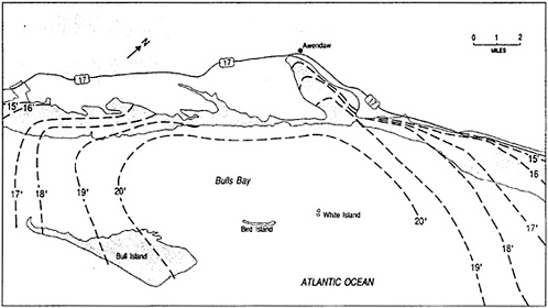
FIGURE 11-1 Storm-surge levels along South Carolina coast (from FEMA).
Carolina, destroying all the beachfront houses in some communities as it made landfall. Building codes were subsequently strengthened and upgraded and Hurricane Diana in 1984 caused relatively little damage (National Research Council, 1986). South Carolina was spared this experience and, hence, did not change its coastal building standards, so the damage inflicted by Hurricane Hugo was devastating. However, many of the newer houses built to FEMA specifications showed markedly less damage (see Chapter 3).
STORM SURGE
As usually occurs in severe conditions, many of the tide gages were destroyed by storm waves during Hurricane Hugo's passage. Fortunately, the tide gage at Charleston operated throughout the event, recording a maximum elevation 12.9 ft. A plot of the predicted tide compared with the observed elevations graphically illustrates the pronounced rise of the water on the night of September 21 (Figure 11-2). The tide gage data clearly show that the storm surge rapidly increased during a few hours, but it is really not quite the “wall of water ” as the press commonly explains the phenomenon. The peak surge occurred as expected to the right of the storm track (Figure 11-1), and the embayed nature of Bull Bay tended to amplify the surge in
TABLE 11-1 Storm-Surge Tidal Elevation Affecting the South Carolina Coast (1893-1979).
|
Storm Date |
Area |
Maximum Storm Tide (ft) |
|
27-28 August 1893 |
St. Helena, Hilton Head |
20 |
|
13 October 1893 |
Georgetown |
13 |
|
25-26 September 1894 |
Charleston |
10 |
|
2 October 1898 |
lower coast |
14 |
|
27-28 August 1911 |
Charleston, Beaufort |
12 |
|
11-15 August 1940 |
entire coast |
13 |
|
17 September 1945 |
Parris Island |
9 |
|
15 October 1947 |
Parris Island |
9-12 |
|
15 October 1954 |
upper coast (Hazel) |
17-18 |
|
9 July 1959 |
Bull Bay (Cindy) |
10 |
|
29 September 1959 |
lower coast (Gracie) |
8-9 |
|
4-5 September 1979 |
Charleston (David) |
8-9 |
this relatively undeveloped area. In South Carolina a typical 100-year return rate storm surge is in the range of 13 to 15 ft (see FEMA Flood Insurance Rate Maps), certainly qualifying Hurricane Hugo as such an event. Little wave data was available, but offshore deep-water readings at NOAA (NDBC) stations indicated a maximum height of 28 ft (Meindl, written communication, 1990).
The average elevation of the low country in coastal South Carolina is about 10 ft above MSL. The outer barrier islands have lower average elevations, 5 ft or less, near the bayside. This means that most of the barrier surface, except for a few high spots, was totally under water during the height of the storm surge. The mainland in this area is all part of the low-lying coastal plain, which gently slopes up to an elevation of approximately 20 ft near U.S. Route 17 (see Figure 11-1). Driftlines of debris and floatables were found across this road just north of Bull Bay, indicating the landward extent of saltwater flooding. Actually, the best data acquired by FEMA for the determination of surge heights for the plotting of isolines across the flooded area were the many houses on the developed barrier islands and inland mainland area. Inside water marks are considered good sources of water elevation information, as the buildings act as stilling wells. There is an extensive amount of information on
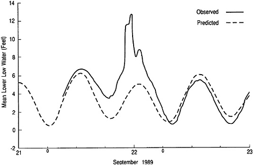
FIGURE 11-2 Observed and predicted tidal elevations at Charleston, South Carolina, for September 21-22, 1989, relative to mean lower low water. Source: NOAA-NOS, 1989.
the storm-surge level from which Figure 11-1 was compiled by FEMA personnel and contractors; this data set is available elsewhere (Gee and Jenson, 1989).
The large storm surge generated by Hurricane Hugo was primarily due to the wind set-up (65 knots [74.5 mph] sustained onshore winds aloft), which literally pushes and piles the water up on shore, and the low atmosphere pressure of the storm at landfall (termed the inverse barometer effect). Rainfall was rather light, and flash floods and the high water levels in rivers normally associated with hurricanes, were not a problem in Hugo. Instead, heavy rain fell several days after Hugo passed, causing extensive interior damage to houses with already damaged roofs (see Chapter 4 and Chapter 5).
While Hugo was clearly the most damaging hurricane to strike the U.S. mainland, its magnitude and surge levels were not as large as those in Hurricane by Camille in 1969. Camille made landfall in Pass Christian, Mississippi, pushing a 22.4-ft storm surge over the low-lying coastal plain. The difference in destruction is directly related to the level of coastal development; directors of the NHC have insisted that the development practices of the past few decades invite disaster. Hurricane Hugo underscored that point.
The height of the storm surge, which varied along the South Carolina coast, is a good index of the damage wrought by this hurricane. The southernmost area to
experience severe destruction was Folly Beach, South Carolina, where the surge was 12 feet above MSL (see Figure 11-1). Islands farther south (Kiawah and Seabrook) experienced only minor surge-related damage, although losses due to high winds on the back side of the storm were still significant. As previously mentioned, the highest surge and most intense waves and winds occurred to the right of the storm path. Fortunately, this immediate area (Bull Bay) was largely undeveloped, but just to the north, at Garden City and Pawleys Island, damage was particularly severe to pre-Flood-Insurance Rate Map (FIRM) houses of inadequate construction according to FEMA 's standards for flood-prone areas (see Chapter 3). The surge was less on the north side of the storm, falling off significantly by the time it reached southeastern coastal North Carolina —the northward limit of wave and surge damage. The degree of erosion also tapered off toward the Grand Strand, where the most heavily developed portion of the South Carolina coast exists at Myrtle Beach.
COASTAL EROSION
Ground reconnaissance and aerial surveys were made of the entire South Carolina coast. The beaches receded markedly, and complete dune lines were eroded along much of the coast. The damage to beachfront houses was extensive on many of the barrier islands near the storm track (e.g., Pawleys, Sullivans, and Follys). It should be noted, however, that the entire erosion potential of Hurricane Hugo was not realized because it passed the coast so quickly, progressing at a rate of 21 knots (24 mph), which is over twice the normal speed of hurricanes.
In addition to the spatial distribution of the storm surge in determining the extent of erosion, the sediment size, which varies along the South Carolina coast, has a secondary influence on erosion. The sediment in the Grand Strand area (near Myrtle Beach area) is of Pleistocene age; while the coarsest sand along the South Carolina coast, it averages only 0.175 mm in mean grain size (fine sand). This material also exhibited some cohesiveness because it has been indurated by humic acids over the past 35,000+ years. By contrast, the sands at the barrier island farther south were finer grained (averaging 0.140 mm) and completely loose, Holocene age sand (Brown, 1977).
Farther south, the island off Garden City was totally overwashed, resulting in massive destruction of houses along this critically low and narrow barrier beach. Overwash sand was transported 400 ft landward on average (Stabule, personal communication). Damage at nearby Pawleys Island was also catastrophic, particularly on the south end of the island where a temporary inlet was cut through the barrier. Houses were floated from the island across the marsh and onto the mainland on the 18-ft storm surge (see Figure 11-1). The two inlets created by Hurricane Hugo were subsequently closed by the U.S. Army Corps of Engineers.
Folly Island experienced considerably more extensive damage as compared with the other barrier island communities, even though it was on the weaker (south) side of the storm center. The beach on Folly Island has been subjected to long-term
erosion, perhaps averaging 2 to 4 ft per year historically (Eiser and Jones, 1989), so that it was already critically narrow before storm occurrence. Folly Island is considered to be relatively stabilized, but subject to dramatic storm-caused erosion. A 1940 hurricane caused an average recession of 75 ft along the beach front, and hurricane erosion in 1959 varied between 35 and 50 ft (U.S. Army Corps of Engineers, 1965). In the process, a complete row of houses has been lost in the last 50 years.
Before Hurricane Hugo, there was essentially no beach along the developed portion of Folly Island (Figure 11-3). Residents had resorted to dumping large stones and concrete rubble on their beaches to form riprap revetments, so that the shore was heavily armored. These preparations were largely ineffective, as the high surge allowed the storm waves to overtop these coastal engineering structures and inflict heavy damages to the beachfront houses.
The Atlantic House, a local landmark and popular seafood restaurant on Folly Beach, was completely destroyed by Hurricane Hugo (Figure 11-4). In actuality, a much smaller hurricane could have claimed this building, as the restaurant was sitting on piles fully in the ocean water during normal tides. The incessant erosion had gradually whittled away the beach so that a ramp over the water was necessary in order to reach this restaurant. While it was the hurricane that swept away the building, it was the long-term erosion that set it up for eventual destruction.
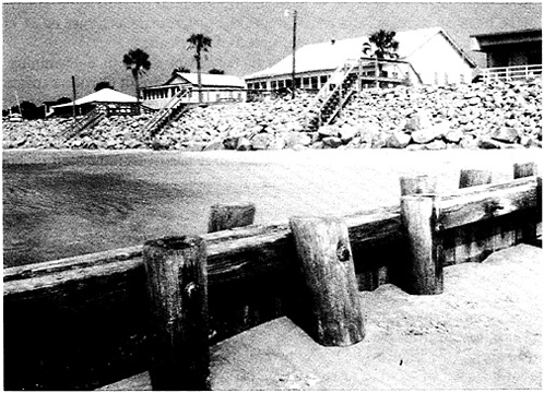
FIGURE 11-3 Pre-storm (July 1989) conditions at Folly Island, showing the limited dry beach area. Courtesy of Tony Pratt.
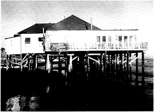
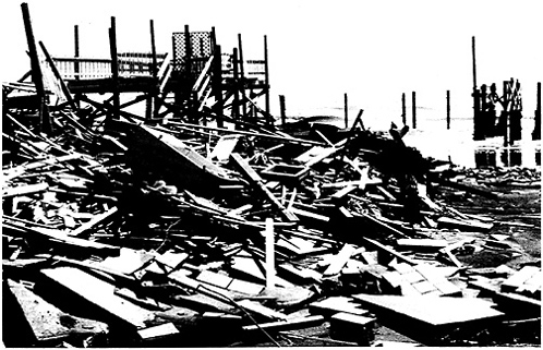
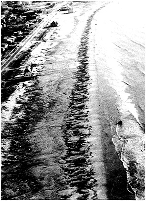
FIGURE 11-5 A wide beach and dune field prior to the storm protected beachfront houses at Isle of Palms.
The importance of acquiring historical shoreline-change data and applying this information to establish building setback lines was well illustrated by the relative damage to beachfront houses in the affected area. The differences in sustained damage at Isle of Palms, which enduned a maximum average storm surge of 12 ft, was striking. While there was extensive damage at Isle of Palms from inundation of the island, beachfront houses were generally protected by a wide beach and sand dunes (Figure 11-5). This storm buffer zone served its purpose well, with damage concentrated where the beaches were narrow and dunes small to absent. The building practices at Isle of Palms were generally consistent with shoreline dynamics, and most damage was inflicted upon pre-FIRM houses sitting on grade. Unreinforced concrete block houses were particularly susceptible to destruction in the V-zone, the floodplain subject to high-velocity wave action. Frequently no more than a few blocks of such houses were found still attached after the storm.
These ill-suited houses appeared to have been “blown out” by the storm surge and superimposed hurricane-generated waves (see Chapter 3).
DISCUSSION
The post-storm field inspection revealed striking differences in the amount of destruction wrought by Hurricane Hugo to beachfront houses in communities along the coast. Houses properly elevated on deep pilings above the storm surge avoided flood damage. Some houses were literally blown apart, indicating that proper construction and building standards must be utilized and enforced to prevent unnecessary damage. FEMA has done an excellent job in setting these standards through the Federal Insurance Administration (National Research Council, 1990), as evidenced by the high survivability of most new homes compared with the pre-FIRM-vintage houses.
Some communities had established of a buffer zone of beach and dunes between the high-energy surf and the beachfront buildings in an attempt to mitigate the effect of storm surge. Some residents, especially on Folly Beach, mistakenly relied upon rubble and riprap for protection, as the storm surge topped and hurricane-driven waves swept over the island, smashing the first line of houses. By comparison, the generally better conditions on Sullivans Island largely reflected the setback of over 100 yards. Here the beach seems to be stable, with a slight accretionary trend reported (Eiser and Jones, 1989). The long-term annual erosion rate was a fairly good indication of the damage experienced, when the overall surge levels are factored in. For example, the beaches at Pawleys Island and Garden City have been eroding at rates exceeding 1 ft per year (Kana, 1988); this certainly contributed to the widespread destruction experienced in these barrier island communities. Lack of a sufficiently wide buffer zone, coupled with severe storm-induced erosion, produced catastrophic damage to beachfront houses.
Myrtle Beach received only moderate to light damage compared with areas farther south. The downtown area was protected by a seawall, which held together despite sustaining fractures in some places. In general, the erosional scarp stopped short of the houses, and the debris line was clearly evident in the grassed yards and on the doorsteps.
Although the recent beach-nourishment project at Myrtle Beach was only a small-scale project, this influx of sand helped to protect the upland property. This sacrificial beach may have served its purpose, but now the town and state must contemplate a new beach-nourishment and dune-building project to restore adequate protection against future hurricanes.
The aftermath of Hurricane Hugo presents a good opportunity to reassess building practices. The general public does not understand very well the process of gradual, long-term beach erosion, tending rather to focus on dramatic events such as hurricanes. Clearly, better data on long-term shoreline changes, public understanding and acceptance of this information, and the promulgation of strict setback standards must be given top priority.
Only a year earlier, in 1988, South Carolina passed the Beachfront Management Act to control unwise development along the open-ocean coast. Provisions of this new law included restrictions on new construction (must be set back at least 20 ft
landward of the actual or estimated dune line) and redevelopment (if two-thirds of a beachfront building is damaged, it cannot be rebuilt). A quick survey of Folly Beach and some of the other barrier islands indicated that over 200 heavily damaged houses fell into this category, making lots valued up to $500,000 essentially worthless (non-buildable). The mayor of Folly Beach claims that 65 percent of the beachfront property has been lost, as well as most of the town's tax base.
Following a disaster of this magnitude, emotions run high, and decisions based on stopgap measures often supersede sound, long-term planning. Millions of dollars were spent under emergency procedures to scrape sand off the beach to rebuild dunes, with little consideration of sustainability. Perhaps more importantly, state legislators are calling for recision of the Beachfront Management Act or at least a liberal interpretation of its provisions, to allow the rebuilding of beachfront homes. Although this is a difficult time to enforce the ban on rebuilding, regulations shoreline properties have in many cases been physically eroded, and any reconstruction must be set back an appropriate distance based on the long-term erosion rate.
National attention is being focused on South Carolina in terms of its recovery from this devastating coastal storm and application of the Beachfront Management Act. Other communities must learn that hard decisions of property rights versus public safety must be made before a catastrophe occurs, and that the public must be aware of the consequences for post-storm construction. Official delineation of an E(erosion) Zone and implementation of a new FEMA directive to fix building setback requirements (National Research Council, 1990) will go a long way to relieve the current dilemma, as well as public misunderstandings.
CONCLUSIONS
-
Tourism is the primary source of state revenue in South Carolina, and coastal resources account for the majority of this income. Therefore, the state of South Carolina must be careful not to allow its beaches to be lost or compromised by unwise development practices.
-
Coastal erosion is a pervasive, ongoing process along much of the South Carolina shore. Because of this, better long-term shoreline-change data is needed, and the public should be educated about the implications. The state should support FEMA's efforts to include erosion hazards (E-Zones) and building setbacks as a part of its NFIP.
-
Shore-protection devices erected by private property owners were convincingly demonstrated to be ineffective in preventing damage to their houses. Instead, this splay of rubble and riprap has ruined many of the natural qualities of the beaches, and in some cases resulted in increased damage when projectiles were pushed into the adjacent structures. Well-designed, -engineered, and -maintained seawalls, such as those at Myrtle Beach and fronting the Holiday Inn on Folly Island,
-
performed quite well. However, the high storm surge was able to sweep over the seawall on Folly Island, inflicting heavy damage on the first floor of the Holiday Inn.
-
The South Carolina Beachfront Management Act is based on the correct premise of disallowing development in damage-prone areas. It also addresses the difficult issue of redevelopment of lots where the previous house was destroyed or significantly damaged. These provisions need to be firmly based on long-term erosion rates and other technical and engineering requirements. However, some level of compensation should be made available to property owners not allowed to rebuild, perhaps based on the fair market value for the proportion of the remaining upland property. Certainly the post-storm value will be considerably less than pre-storm assessments because of storm-induced land loss. This proactive approach by the state will avoid expensive litigation over private property rights and will allow the state to maintain an uncluttered public beach.
-
New construction within a designated zone, landward of the setback line, should be built on deep-seated pilings as movable structures. As erosion proceeds, these houses with the upgraded building standards will probably be able to survive future storms and eventually outcrop on the public beach. Texas has instituted an Open Beaches Act that forces homeowners to move their houses off the newly declared public beach. While this prospect may seem to be several decades away, now is the time to set public policy, not when the problem is at hand.
-
South Carolina must limit current and possible future coastal development. Community planning must be instituted in terms of any protective action, such as beach nourishment. Also, a mutually agreed time frame of up to 50 years must be incorporated into planning efforts.
-
At the national level, FEMA needs to incorporate erosional trends into its flood insurance program, as clearly stated in the 1990 National Research Council report, “Managing Coastal Erosion.” Failure to consider erosion as part of the natural flood hazard and overall shore vulnerability tends to undermine federal programs by allowing insurance rates to be set substantially below those for the actual risk and by condoning inadequate construction regulations.
REFERENCES
Brown, P. J. 1977. Variations in South Carolina coastal morphology. Southeast Geology 18: 249-264.
Eiser, W. C. and C. P. Jones. 1989. Analysis of Beach Survey Data Along the South Carolina Coast, Fall 1988. Columbia, South Carolina: Coastal Science and Engineering, Inc.
Gee & Jenson, Inc. 1989. Preliminary Post-Storm Survey Report on Hurricane Hugo to FEMA. West Palm Beach, Florida. Unpublished report sponsored by Property Claims Service and Flood Insurance Company.
Hayes, M. O. 1979. Barrier island morphology as a function of tidal and wave regime. Pp. 1-27 in Barrier Islands, S. Leatherman, ed. New York, New York: Academic Press.
Kana, T. W. 1988. Beach Erosion in South Carolina. Charleston, South Carolina: South Carolina Sea Grant Consortium.
National Ocean Service. 1989. Hurricane Hugo: Effects of Water Levels and Storm Surge Recorded at NOAA-NOS Level Stations. Rockville, Maryland: National Oceanic and Atmospheric Administration.
NRC. 1986. Hurricane Diana, North Carolina, September 10-14, 1984. Committee on Natural Disasters, National Research Council. Washington, D.C.: National Academy Press.
NRC. 1990. Managing Coastal Erosion. Marine Board and Water Science and Technology Board, National Research Council. Washington D.C.: National Academy Press.
U.S. Army Corps of Engineers. 1965. Interim Hurricane Survey of Folly Beach, South Carolina. House Document 302, 84th Congress.


