
C Practical Application of Shiphandling Simulators to Waterway Design
CASE STUDY COATZACOALCOS, MEXICO COMPUTER AIDED OPERATIONS RESEARCH FACILITY, 1980-1981
PROJECT DESCRIPTION
Exxon Corporation sponsored a simulation study at the Computer Aided Operations Research Facility (CAORF) to determine the maximum size oil tanker that could safely load at Coatzacoalcos, Mexico. The exit from the loading docks requires passage through a narrow, 330 foot wide channel cutting obliquely across the Coatzacoalcos River. Very high river currents were reported during the rainy season. The harbor chart is shown in Figure C-1.
SIMULATION DESCRIPTION
CAORF, a government-owned but privately operated facility located on the grounds of the U.S. Merchant Marine Academy, Kings Point, New York, was selected to conduct the simulation study. Real-time simulations were conducted using local pilots. Simulations compared the performance of the larger ships proposed for this service with that of ships actually using the
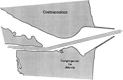
FIGURE C-1 Coatzacoalcos Harbor.
port. Generalized mathematical models were used in the simulations based on material available for similar ships.
Field visits were made to develop visual effects for the simulation, to observe the performance of ships using the port, and to measure environmental effects (river currents). Measured river current velocities were found to be significantly less than those reported by local pilots and harbor authorities. As a result, a considerable amount of additional testing and interpolation of results was necessary.
SIMULATION RESULTS
The simulation indicated that tankers about 10 percent larger (70,000 deadweight tons [DWT]) than those currently used could be safely loaded at this port. The larger tankers required a slightly greater under-keel clearance than the smaller tankers during the rainy season (U.S. Maritime Administration, 1980, 1981).
PROJECT IMPLEMENTATION
Larger tankers regularly began using this port in late 1981. The cost of simulation was recovered in less than 2 months of operation of the larger ships.
LESSONS LEARNED
Design Team
A shiphandling simulation is not a simple engineering project. Success depends on assembling a team of qualified and imaginative professionals (hydrologists, hydrodynamicists, pilots, simulator operators, and end users) and managing that team in a way that encourages each member's full contribution.
Pilot Participation
Local pilot participation was important to verify qualitatively the accuracy of the simulation. In this study, changes in the treatment of bank effects were made as a result of pilot advice.
Operating Parameters and Costs
Significant economic savings may be gained from relatively modest changes in permissible operating parameters.
Data Validation
Assessments of environmental data that are not supported by accurate field measurements should be carefully weighed before they are accepted.
CASE STUDY NORFOLK/HAMPTON ROADS, VIRGINIA COMPUTER AIDED OPERATIONS RESEARCH FACILITY, 1980-1986
PROJECT DESCRIPTION
The State of Virginia sponsored a simulation study to improve existing channel designs so as to permit deep-draft coal colliers of 225,000 DWT and 55-foot draft. The objective of the project was to make Hampton Roads ports (Figure C-2) more competitive in the world coal market.
SIMULATION DESCRIPTION
This project was the first large-scale, real-time and fast-time simulation undertaken by the U.S. Army Corps of Engineers (USACE) for a U.S. port.
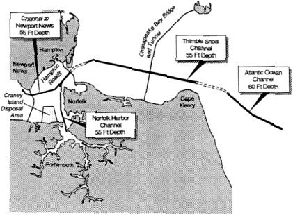
FIGURE C-2 Hampton Roads (USACE).
Simulation costs were about $1.3 million. The simulation was performed at the Computer Aided Operations Research Facility (CAORF). Thirty state-licensed pilots from the Virginia Pilots Association and 19 docking masters affiliated with tugboat companies participated in the real-time simulation for the Norfolk and Hampton channels. Fast-time simulation was used to evaluate ship maneuverability in Thimble Shoal Channel and the Atlantic Ocean Channel. The Chesapeake Bay physical model as well as numerical models developed by the USACE Waterways Experiment Station, Vicksburg, Mississippi, were used to evaluate the environmental conditions in these channels (USACE, 1986a).
SIMULATION RESULTS
The simulation indicated that the new channel design would permit bigger and deeper colliers to sail safely from Hampton Roads ports. The simulation recommended maintaining some channel widths as they were initially designed and reducing others, for example, from 1000 feet to 650 feet. Savings of over $100 million were projected as a result of reducing the amount of required dredging (U.S. Maritime Administration, 1985).
PROJECT IMPLEMENTATION
The project is to be implemented in two phases: channel widening and depth to 50 feet, then depth to 55 feet if economically required. Phase 1 was completed in 1988; Phase 2 is under review.
LESSONS LEARNED
Consensus Building
As a result of the simulation, the channel design was extensively coordinated with the U.S. Coast Guard, U.S. Maritime Administration, Virginia Pilots Association, Virginia Port Authority, USACE, and others. This cooperation resulted in an effective channel design effort with significant cost savings.
Effectiveness as Design Aid
The simulation demonstrated that an asymmetrical channel design would not impair the safe movement of large, deep-draft vessels in confined channels. The combination of real-time and fast-time simulation provided an effective tool for analyzing various channel design options.
Risk Assessment
Simulation runs were not based on worst-case conditions. As a result, vessels may be at risk when encountering these severe conditions, and operating practices need to be developed by the port users to account for these untested risks.
CASE STUDY JOHN F. BALDWIN, PHASE 2 (RICHMOND LONG WHARF) WATERWAY EXPERIMENT STATION,1983-1984
PROJECT DESCRIPTION
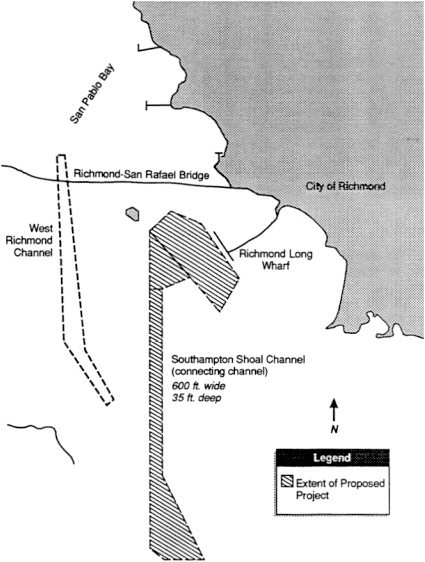
The simulation study was designed to verify the validity of the final design for a major ship channel improvement project in Richmond, California, in the Upper San Francisco Bay (Figure C-3). A design had been completed that involved deepening the Southampton Shoal Channel (connecting channel) and maneuvering areas to the Richmond Long Wharf in
order to permit the discharge of fully loaded 85,000 DWT tankers and partially loaded 150,000 DWT tankers at this port. The design's suitability for large containership operation into the Richmond Harbor navigation channel was also to be checked.
SIMULATION DESCRIPTION
This simulation was undertaken by the USACE Waterways Experiment Station (WES), located in Vicksburg, Mississippi. It was one of the earliest simulations conducted at this facility. Only modest graphic display capability was available.
Generalized mathematical models were used in the simulation based on material available for similar ships. Environmental data were either measured from scale hydraulic physical models or based on local records as appropriate. Several simplifying assumptions were made in setting up the simulation in the interest of saving time and reducing costs.
Real-time simulations were done for both tankers and containerships. Only limited use was made of experienced pilots, with 36 of the 41 simulation runs being done by WES engineers (Converse et al., 1987; Huval et al., 1985).
SIMULATION RESULTS
The simulation indicated that the initial design was suitable for use by the intended tankers and the smaller (638 foot length overall [LOA]) containerships. However, operation of the larger (810 foot LOA) containerships was not recommended with this design because of tidal currents expected in this port. Significantly less dredging was found to be necessary than was initially proposed for the maneuvering area.
The simulation, which cost only $110 thousand, resulted in a $1.8 million direct savings in dredging costs out of a total project cost initially estimated to be $12.8 million. A value engineering analysis, performed later using additional simulation testing, produced an additional $2.2 million in dredging savings.
PROJECT IMPLEMENTATION
Southampton Shoal Channel and the Maneuvering Area were dredged in 1986 in accordance with the USACE design as revised by the simulation results and the value engineering analysis. Satisfactory operation is reported for the intended tanker traffic and smaller containerships. Additional studies for improvements to Richmond Inner Harbor and approaches are under way.
LESSONS LEARNED
Design Team Skills
This simulation was successfully used for design verification and cost reduction despite its relatively modest level of sophistication and the limited simulator operating experience of the WES staff for this early simulation. These limitations were addressed by using appropriate safety reserves when applying the simulation results.
The success of this particular simulation owed much to the skill of the simulation-design team in simplifying the simulation so as to obtain meaningful results in a timely manner. Their success clearly illustrates the importance of having a skilled team doing simulations.
Pilot Participation
The advice of the experienced ship pilots, although limited, was invaluable in validating the suitability of visual displays and the behavior of known vessels under known conditions.
Despite the significant cost savings achieved, the simulator apparently was not used to its fullest capabilities as a design optimization tool. Additional simulations with experienced pilots might have indicated ways to narrow the design width of the connecting channel (for example, by flaring the upper end, which is critical for setting up the turn). The impact of tug usage was not explored until the value engineering study, due to earlier miscommunications with the pilots.
Consensus Building
The simulation study was reported to be of great value in achieving consensus among various interested groups with divergent views on design requirements.
Graphics Displays
Precise fidelity of the graphic display is not always necessary for a successful simulation, but accuracy of perception is. Correct relative placement of visual objects, navigation channel, and environmental data (for example, currents, winds) is critical. The relative importance of display fidelity varies from project to project.
CASE STUDY PANAMA CANAL GAILLARD CUT WIDENING STUDY COMPUTER AIDED OPERATIONS RESEARCH FACILITY, 1983-1986
PROJECT DESCRIPTION
The Panama Canal Commission (PCC) conducted a study of canal modifications to permit two-way traffic of Panamax-size vessels throughout its length which in turn would lead to increased throughput of large ships. At present, the Gaillard Cut is the narrowest section of the canal (Figure C-4). It is 500 feet wide with several curves, which makes the meeting of Panamax vessels dangerous at this point.
The Gaillard Cut Widening Study was intended to determine the dimensions for optimum navigation channel that would afford a reasonable balance between excavation cost and safety. Technical, operational, economic, financial, and environmental considerations were evaluated by the PCC during the study.
SIMULATION DESCRIPTION
The simulation, conducted by the Computer Aided Operations Research Facility (CAORF), was the longest waterway design simulation effort undertaken. Real-time and fast-time simulation were used. Field visits were made to develop visual effects, observe vessels using the canal, and mea-
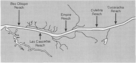
FIGURE C-4 Gaillard Cut, narrowest section of the Panama Canal.
sure environmental effects for simulation. The model ship was developed by the Swedish State Shipbuilding Tank (SSPA) (Eda et al., 1986; Kaufman, 1986; Moody, 1970; Puglisi, 1986; Puglisi et al., 1984, 1987; U.S. Maritime Administration, 1983-1986, 1986).
Criteria for Measuring Safety Performance
Safety criteria were not available for evaluating ship performance in passing maneuvers relative to alternate channel configurations. Therefore, it was necessary to establish the framework and measures needed to evaluate simulation results, including collection of supporting data. A multidimensional performance measure, referred to as the steering quality profile, was developed for quantifying the degree of safety achieved during passing evolutions. Meetings and passings of the largest ships currently allowed to meet and pass was selected as the baseline for evaluating comparative performance of Panamax ships, the largest allowed to meet and pass in the widened cut. A generic bulk carrier, 608 feet in length with an 85 foot beam, was selected to represent the largest ships currently using the cut.
Model Validation
The mathematical model was validated using comparisons of simulated ship trajectories and actual ship trajectory data collected during transits of the Gaillard Cut. Subjective evaluations of simulator performance by pilots from the Panama Canal Commission were used to further refine the autopilot model. Simulation scenarios were constructed so that meetings and passings would occur in a straight reach near each turn. The scenarios were further refined so that meetings and passings would occur at the most difficult locations for maneuvering. If acceptable performance were achieved at the most difficult locations, then equal or better performance could reasonably be expected elsewhere.
Fast-time simulation was selected to screen hundreds of design variations and eliminate those that were clearly unacceptable. The coefficients used in mathematical models by SSPA and CAORF for fast-time simulation were derived from SSPA model tests for Panamax ships. Comparison of trajectories from the model test and fast-time simulations using the mathematical models determined that performance agreed within ten percent. This level of accuracy was considered acceptable for initial screening of configuration feasibility.
Fast-Time Screening of Design Alternatives
A screening strategy was developed to permit ranking and selection of alternate waterway configurations. Computer data bases were created for over 1500 configurations. Excavation volumes, determined by the commission for each alternative, were used to rank each in terms of economic desirability. The data bases were organized and stored electronically to facilitate data searches.
For each curve in the waterway, operating conditions were correlated with alternate configurations to form a problem matrix. Fast-time screening began with the least costly configurations. Meeting and passing evolutions were executed under varying operating conditions. Operating conditions were derived from observations of actual shiphandling and ship behavior and ranked according to their effect on passing maneuvers. Progressively wider configurations were used to establish minimum widths needed to permit safe passage under progressively more difficult operating conditions. Following each run, data were examined using regimes built into the computer program to confirm that test parameters for operating conditions were within prescribed tolerances (that is, combined meeting speed within plus or minus 1 knot of designated speed, and meeting location within 1/2 ship-length of the intended location). If tolerances were exceeded, the computer program automatically adjusted the initial speeds or starting location and repeated the run. If a run passed screening criterion, then the next set of operating conditions were selected for that configuration. If a run failed, then the next configuration was loaded according to the ranking strategy. The process was automated so that all runs for each turn could be executed and analyzed without human intervention. Based on the overall results, the commission choose one configuration for each curve which struck a balance between cost and the range of operating conditions for which safe passages could be expected. This constituted the finite number of configurations that would be further evaluated using real-time simulation.
Configuration Assessment Using Real-Time Simulation
Real-time simulation was used to better determine the acceptability of the waterway configurations selected through the screening process for each turn. Pilots employed by the commission participated in full-mission simulation of meetings and passings of Panamax vessels for selected configurations under varying operating conditions. Steering quality profiles generated from pilot directed maneuvers were compared with baseline criteria for measuring safety performance. For 6 of 8 locations for which data had been collected, average performance of the pilot validation group in terms of ship trajectories was better than the baseline safety level. In 7 of the areas
simulated, average pilot performance was equal to or better than baseline safety levels. Only in one area were minor configuration refinements needed to achieve acceptable performance.
SIMULATION RESULTS
Simulation indicated that if the Gaillard Cut was widened to various widths, then longer and wider (in beam) ships could safely pass each other, which would increase canal throughput by many vessels per year.
PROJECT IMPLEMENTATION
Political instability in Panama has impeded the project schedule. The Pacific Entrance Channel modifications have been partially implemented and were scheduled for completion by late 1990. Widening of the Gaillard Cut began in early 1992.
LESSONS LEARNED
Technical
The study demonstrated that simulation can be used as a cost-effective tool in the design process. It further indicated that
-
subjective measures are important in the project evaluation process;
-
fast-time analysis can be used to determine what layout alternatives are most likely to succeed, thereby overcoming complex interactions that might have otherwise prohibited analysis;
-
accuracy of simulation mathematical models could be achieved within 10 percent of each other; and
-
visual observation of vessel tracks could be used to validate fast-and real-time simulation.
Simulation results coupled with design manual guidelines resulted in identifying areas for which dredging was not needed. This finding resulted in projected cost savings of up to $400 million. Simulation showed that alternate vessel tracks fell both inside and outside of the guidelines of the Permanent International Association of Nautical Congresses.
Project Management
Lessons learned relevant to project management included:
-
pilot participation in the real-time simulation could be used to verify the validity of the simulation to the satisfaction of participants,
-
all participants in the study wanted considerable confidence in the appropriateness of the selected design vessel, and
-
development of the compressed time simulation decision model and automatic execution process was more complex than standard real-time simulation.
CASE STUDY GRAYS HARBOR, WASHINGTON WATERWAYS EXPERIMENT STATION, 1986
PROJECT DESCRIPTION
The Port of Grays Harbor, Washington, wished to verify the feasibility of the final design for a major ship channel improvement project. A design was completed for widening and deepening of 24 miles an estuary and bar channel, improvement of a highway bridge fendering system, and replacement of a rail bridge.
The port sponsored a simulation study by the Waterways Experiment Station (WES) to provide additional input for the final project because of
-
high project cost,
-
increasing size of the primary vessel type (log carriers) used in original design,
-
concern over the adequacy of the turning basin,
-
uncertainty over the alignment of the channel in relation to proposed modifications of the bridges, and
-
continued concern by environmentalists for a sensitive underwater habitat.
SIMULATION DESCRIPTION
Real-time simulation, using Grays Harbor pilots for verification, was conducted using the WES simulator. Extensive environmental information was available for use in the simulation as part of the basic U.S. Army Corps of Engineers (USACE) navigation project on channel width. All four Grays Harbor pilots participated in the study in close coordination with the local Seattle District, USACE (Hewlett and Nguyen, 1987; Waller and Schuldt, n.d.; Whalin, 1986, 1987).
SIMULATION RESULTS
The simulation indicated that dredging requirements could be safely reduced in the 8 mile channel section from South Reach to Cow Point from 400 feet to 350 feet (existing width) with widening at bends only (see Figure C-5). This finding resulted in a reduction of 1 million cubic yards of dredging in an environmentally sensitive reach out of a total of 17 million cubic yards.
The simulation also indicated that larger vessels than initially anticipated could be safely used in this harbor with only slight modifications in channel design. The size of turning basin was also determined to be adequate for the large ship.
PROJECT IMPLEMENTATION
Simulation recommendations have been incorporated into the final project specifications. The project is currently under construction.
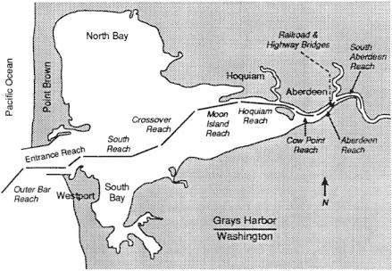
FIGURE C-5 Grays Harbor, Washington.
LESSONS LEARNED
Consensus Building
The simulation made the basic design project credible for a diverse group of project participants. This result was especially valuable when addressing environmental concerns.
Cost Savings Through Simulation
Cost savings that resulted from the Grays Harbor simulation were significant—about 10 times the cost of the simulation.
Design Tool
Current general design rules for ship turning basins may result in construction of basins larger than necessary, based on the Grays Harbor experience.
CASE STUDY OAKLAND HARBOR COMPUTER AIDED OPERATIONS RESEARCH FACILITY, 1986-1988
PROJECT DESCRIPTION
The Port of Oakland sponsored a simulation study at the Computer Aided Operations Research Facility (CAORF) to develop alternative channel designs for the Inner and Outer Oakland harbors (Figure C-6). The objective was to find suitable designs that would open the port to larger, more cost-efficient containerships in order to maintain the port's competitive position relative to other West Coast container ports. A channel dredged to 42 feet was a key project feature. Ships entering the port are subject to adverse current and wind conditions (U.S. Army Corps of Engineers [USACE], 1988).
SIMULATION DESCRIPTION
The study used the shiphandling simulator at CAORF to evaluate channel designs. Pilots from the San Francisco Bar Pilots Association participated in the real-time simulation. Two other models were used—the San
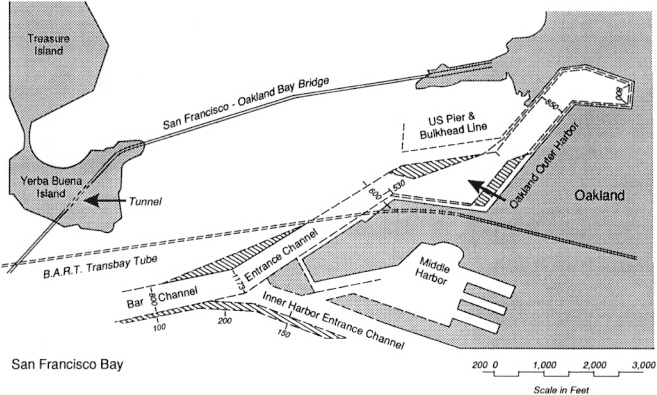
Francisco Bay physical model operated by the San Francisco District and the Mooring Line simulation model at the Stevens Institute of Technology. The bay model provided values for water currents. The Mooring Line model determined surge effect on moored vessels. The Waterways Experiment Station (WES) in Vicksburg, Mississippi, provided technical support for current modeling (U.S. Maritime Administration, 1987).
PROJECT RESULTS
The simulation indicated that significant safety benefits could be derived by widening the entrance channel and the westernmost part of the outer harbor channel beyond the widths initially proposed and by tapering the width of the remaining outer channel to its present size, thereby minimizing wake damage to moored vessels. Tapering the outer harbor channel precluded the costly relocations of subway (BART) cables and platforms, which was initially planned. Channel width modifications reduced the turning basin design from 1800 to 1600 feet.
PROJECT IMPLEMENTATION
The final proposed design was approved by the USACE in 1988. The Port of Oakland decided to accelerate phase one of the project (deepening the inner harbor to 38 feet). Dredging was to begin in 1988 as a port-sponsored initiative. However, legal and regulatory challenges concerning port involvement and disposal of dredged material effectively halted the port's implementation activities.
Additional interested parties emerged who were not involved in the simulation or other aspects of the design and approval process. The environmental and commercial fishing concerns of these parties were not satisfied by the disposal plans for dredged material from the prospective project, and implementation was stymied. Some objections, especially from the commercial fishing community, were unexpected because fishing concerns apparently had been addressed. However, not all interested fishermen had been involved, and legal challenges were initiated regarding the offshore disposal of dredged material that they alleged could adversely impact their fishing grounds.
The port overcame or accommodated most of the various challenges to the deepening project. However, the port was unable to obtain approval for a suitable offshore disposal site. Escalating costs that occurred in the interim and additional objections to alternate sites have affected the economic viability of what were once promising disposal options. These options included the possible use of dredged material to restore marine habitats within distant reaches of the estuary and to dispose of it in the Sacramento
River Delta for use as dike construction material by reclamation officials (Kagan, 1990). The port was also unable to resolve legal issues about construction of a part of an authorized federal project by a non-federal organization. As a result, the port discontinued its effort to accelerate completion of phase one and is awaiting USACE implementation following normal procedures.
LESSONS LEARNED
Consensus Building
Simulation brought together parties with interests in project design. It resulted in improved communication and better understanding of project problems, alternatives, and design requirements. Channel design with the aid of simulation provided meaningful data about issues that were previously analyzed subjectively.
Identification of Interested Parties
Although the simulation study was successful, the original identification of parties interested in the project was incomplete, even though some concerns (such as disposal options for dredged material) did not affect design configurations evaluated through simulation. If all parties had been included in the simulation process from the beginning, the same common ground among other parties may not have been achieved. However, the noninvolvement of these late arrivals in the design and approval process has jeopardized project viability (Kagan, 1990).
Design Ship
The appropriate selection of the design ship to be modeled is very important to successful simulation. The Econoline vessel used in this study was not considered to be a good choice. Pilots found it unusually difficult to handle, and it is also believed to be smaller than the ships expected to use the port when the project is completed.
Although additional simulations were recommended to evaluate the performance of the larger vessels expected to use this port (new vessel beam 130 feet versus Econoline beam of 106 feet), the additional work was not done. Thus, the potential exists for larger vessels to operate in a confined, shallow channel without the benefit of supporting simulation data to determine margins of safety for such operations.


