
1
What is Known About Seismic Risk Nationally?
Over 41 states in the United States are subject to damages and losses from earthquakes. Although California is the area most frequently associated with earthquake events, other areas of the country are also at risk, notably: the Puget Sound area in Oregon and Washington; the Wasatch fault area in Utah; the New Madrid fault area in the central United States; Charleston, South Carolina; the Boston-New York area; Alaska; Hawaii; and Puerto Rico. This chapter establishes the scientific basis for earthquake risks in these areas as well as "probabilities" (where such evidence exists) for when future earthquakes are likely to occur in various metropolitan centers.
Dr. Robert M. Hamilton is with the USGS. Dr. Hamilton's doctoral degree is in geophysics from the University of California at Berkeley. He has been with the U.S. Geological Survey since 1968 in a variety of roles, including Chief Geologist, Chief of the Office of Earthquake Studies, and coordinator of the Deep Continental Studies program. He is also past president of the Seismological Society of America. Beginning in August 1990, Dr. Hamilton accepted a 2-year post at the Secretariat of the International Decade for Natural Disaster Reduction (IDNDR) in Geneva.
PRESENTATION OF ROBERT M. HAMILTON
This presentation gives a brief overview of the nature of earthquake hazards in the United States. It will necessarily be a once-over-lightly treatment, but hopefully it will at least help to set the stage for some of the later chapters. Progress in understanding the nature of earthquake hazards in the United States has been very rapid over the last 25 years. Twenty-six years ago the concept of plate tectonics was only emerging. That concept now provides an understanding of the forces that cause earthquakes, and it is the basis for long-term earthquake predictions that have been made in some parts of the world, particularly around the rim of the Pacific Ocean, and especially in California.
As recently as 15 years ago, there was no geologic explanation for the four magnitude 8 earthquakes that struck New Madrid, Missouri, in 1811–1812 and devastated the area. Because they occurred in the middle of the North American plate, ordinary concepts of plate interaction did not fit. Geologists now understand that those earthquakes were caused by flexing within the North American plate, causing reactivation of a rift in the crust of the earth that formed over 500 million years ago. That rift has been reactivated repeatedly.
Just as there are differences between the causes of earthquakes in the western United States and in the East, there are also major differences in the way they affect structures and the way seismic-wave energy is propagated. For a given-magnitude earthquake, eastern earthquakes shake a much greater area than those in the West, about 20 times the area as a rough approximation. Although there are fewer earthquakes for a given period of time (that is, a lower frequency of earthquakes) in the East, the greater area that they affect somewhat offsets this lower frequency.
Figures 1-1 through 1–24 illustrate the ideas that give rise to understanding the cause of earthquakes. Also discussed are some of the effects of earthquakes that are relevant to this paper.
Figure 1-1 is a map of the world with dots that show the locations of earthquakes over a long period of time. They are not randomly distributed, but are located in narrow bands that define the boundaries of the large plates that make up the outer shell of the earth. The earthquakes are caused by colliding and scraping between these plates. The area of greatest earthquake activity is around the rim of the Pacific Ocean. In California, the San Andreas fault system makes up part of the boundary around this rim.
Figure 1-2 shows the plate boundary. As illustrated, the western margin of the United States is part of the boundary of the Pacific plate. The Pacific plate is drifting toward the northwest relative to California and the North American plate. Offshore California, including the Los Angeles area, is headed toward the Aleutian Islands. In several tens of millions of years, Los Angeles will become a suburb of San Francisco and then drift to be subducted into the interior of the earth, melting down and becoming a part of the Aleutian Island chain.
The central part of the United States, including the New Madrid area and the eastern United States, is in the middle of the North American plate. One problem in trying to understand central and eastern U.S. seismicity lies in understanding the origin of the forces that cause those earthquakes in the context of our general model of plate tectonics.
Figure 1-3 shows the processes of plate tectonics. Along the midocean ridges (e.g., along the middle of the Atlantic Ocean, or along the eastern part of the Pacific Ocean) partially molten material rises from the interior of the earth into the crust, where it cools to form new crust and then moves out in both directions. Where the plates collide, one plate goes under and one overrides. For example, along the Aleutian Arc, or along Japan, and anywhere in the western Pacific, the oceanic plate goes under the continental plate. Along those boundaries there are volcanoes, mountains, and a lot of earthquake activity. In some places, plates more or less scrape horizontally past each other, which is the case along the San Andreas fault.
Of course, the stresses that are associated with earthquakes are elastic forces. The stresses build up, much as when a yardstick is bent; when stresses become too great, the stick snaps. Similarly, elastic energy is released by the sudden movement of the plates. This energy propagates outward, shaking the ground and causing the earthquake effects that we are concerned about.
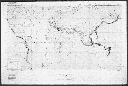
FIGURE 1-1 Global distribution of seismicity.
As previously noted, U.S. earthquake activity is associated with the North American plate (Figure 1-4). The plate boundary lies along the western margin of the continent; a lot of the plate-related activity extends into the western part of the United States as far as the Wasatch front in Utah. The Pacific plate is moving at about 8 cm per year relative to the North American plate, which is moving at about 2.5 cm per year. The New Madrid earthquake zone and all the other activity along the eastern margin is located within the North American plate.
Focusing on California, Figure 1-5 shows that earthquake activity is not in a narrow zone along the San Andreas fault, but rather occupies a fairly broad zone. There is an earthquake band, actually the boundary of the plate, that extends through the Gulf of California (Sea of Cortez) into the Imperial
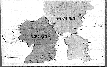
FIGURE 1-2 Earthquakes and global tectonics.
Valley, and along the San Andreas fault system (which, in reality, is whole series of faults). Activity also runs through the Owens Valley into western Nevada, and there is a lot of activity along Cape Mendocino. It is a fairly complicated band of broad activity.
In southern California, particularly, things are very complicated. Figure 1-6 illustrates the concept that the San Andreas fault system is not just one boundary between the North American plate and the Pacific plate, but rather is a complex zone of block. In general, Los Angeles is moving north, but there are other blocks that are moving in different directions. In the transverse ranges (e.g., the Santa Barbara area) these blocks have to move out of the way to the west, which is why the mountains are there. The Mojave Desert block has to skip out to the east.
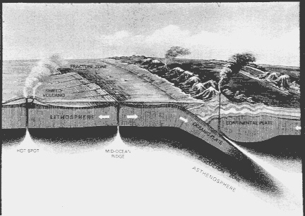
FIGURE 1-3 Schematic cross section illustrating plate tectonics processes.
The concept portrayed here is that the fault zone itself is a complex zone of faults and blocks that jostle each other. It is much like blocks of ice drifting on a river, where the underlying current of the river is moving the blocks along. As the blocks move, they shift to accommodate the presence of other blocks. That is a pretty good model to portray the crust of the earth: a bunch of blocks that are floating on a fluid interior and jostling around in order to accommodate that movement.
In California, there have been a series of very strong earthquakes. The 1906 earthquake broke the San Andreas from just north of San Juan Bautista toward Cape Mendocino. That was the last magnitude 8 earthquake in California. In 1857 another magnitude 8 earthquake that all the way from the Fort Tejon area south to the Mojave Desert. There was a magnitude near-8 earthquake in 1872 in the Owens Valley.
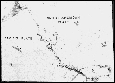
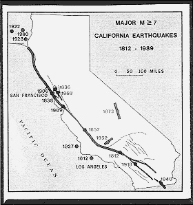

FIGURE 1-6 The San Andreas fault system.
In California prior to 1906, there was a rash of magnitude 6 and 6.5 earthquakes. Charles Richter, in his book on elementary seismology, states that there were approximately one dozen earthquakes of magnitude 6 to 6.5 that occurred in the 70 years before the 1906 earthquake. After the 1906 earthquake, there was a quiescent period where the rate of earthquake activity was not as high. This indicates that a build-up of stresses increased the tension within the crust of the earth, culminating in the 1906 earthquake, which was followed by a relaxation of tensions afterward.
Many seismologists and geologists feel that we are now entering a period of increased stresses and that we are once again going through a cycle of high earthquake activity. Whether that cycle will culminate in a magnitude 8 earthquake in 50 years, 100 years, or 200 years is a research question, but the concept of the cycle is fairly well accepted.
The following section focuses on the Loma Prieta earthquake and uses that event to illustrate some of the points about the effects of earthquakes.
The Loma Prieta earthquake occurred along the San Andreas fault system in the Santa Cruz Mountains (Figure 1-7). Generally, the earthquake was caused by the west side of the San Andreas fault moving upward about
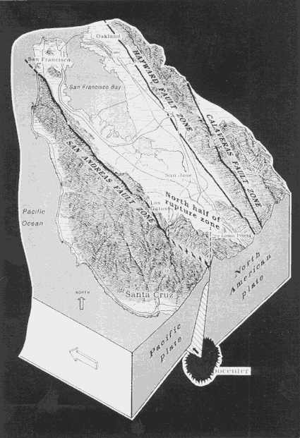
4 or 5 ft and shifting to the northwest about 4 or 5 ft. There was a sudden shift of the crust of the earth, up and to the northwest relative to the eastern side of the fault. This happened virtually instantaneously.
The effects of the earthquake were felt widely. Many of the effects occurred in the San Francisco Bay area, over 50 mi from the epicenter of the earthquake. This was not a big earthquake, and it was not located in the Bay Area. These are very important considerations because, had it been bigger and had it been in the Bay Area, the effects would have been much greater. Other effects were located in the Salinas River valley. Santa Cruz was hard hit. However, a lot of the damage was in the San Francisco area, particularly the Marina District and, of course, in Oakland, where the freeway collapsed.
Figure 1-7 shows a cross section of the San Andreas fault zone from the side, and from the surface to a depth of about 20 km (about 12 mi). The main shock occurred about 10 mi deep, and the aftershocks of the earthquake filled in a seismic gap along the San Andreas fault. The Loma Prieta earthquake, in effect, filled in a patch of the fault that had been stuck; that is, that had not moved in a long time.
Figure 1-8 illustrates cross sections of seismic activity along the San Andreas fault. These cross sections run from near San Francisco to central California. The top portion of the figure shows earthquake activity that had occurred in the several years before the Loma Prieta earthquake. In general, the fault is well covered with earthquake activity except for a gap where there have not been any earthquakes. Such a gap is, in effect, a stuck area on the San Andreas fault. The activity from the Loma Prieta earthquake which filled in the gap. Thus, we have developed a detailed understanding of the mechanics of how the San Andreas fault works, and we can identify other places along the fault that are stuck. This is one of the ways in which long-term earthquake prediction on the San Andreas fault can be carried out.
Figure 1-9 shows that the Loma Prieta earthquake occurred at a depth of about 16 km, or 10 mi. The fault break extended from that depth to near the surface, close to the San Andreas fault.
One of the important things about this earthquake, particularly with regard to economic consequences and the probabilities of earthquakes, is that this section of the San Andreas fault had been identified in a 1988 USGS report as the most likely place in northern California along the San Andreas fault for earthquake activity. Figure 1-10 was taken from that report. In northern California, there is an area in the southern Santa Cruz Mountains that approximately coincides with the section of the fault that subsequently broke. Therefore, this is encouraging to geologists and seismologists working on this problem, because it indicates that those places that are most vulnerable can begin to be identified. As a basis for allocating scarce resources in dealing with the earthquake threat, one can identify the most vulnerable places and focus efforts there. In southern California, there also are areas of great concern.
Following are a few of the effects of the earthquake. The Bay Bridge collapse (Figure 1-11), resulted from a flexing or a stretching of the bridge
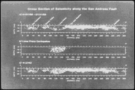
FIGURE 1-8 Cross section of seismicity along the San Andreas fault.
caused by the seismic waves. A very common problem in the Marina District was the failure of the ground and intense shaking. Numerous multistory buildings either collapsed or titled quite a bit (Figure 1-12 ). Many of the problems were caused by open bays in the bottom of the buildings that are used as parking garages. There are not very many shear walls in the lower part of these structures, which allows them to shift.
In the Marina District in San Francisco, a phenomenon occurred that is very important. It is called liquefaction. Liquefaction occurs when sand is shaken and, in effect, turns into fluid that can then squirt out onto the surface of the ground, as in a volcano. Figure 1-13 shows evidence of liquefaction in the Marina. This is probably one of the phenomena that caused the intense shaking and ground failure in the Marina District. It is also important in other parts of the country. In the New Madrid area, in 1811 and 1812, thousands of square miles of land were covered with sand from intense liquefaction. We can anticipate that in the Mississippi Valley area, the next time there is a magnitude 8 earthquake, there will be a lot of water standing on the surface of the ground and a lot of sand deposited all over the place.
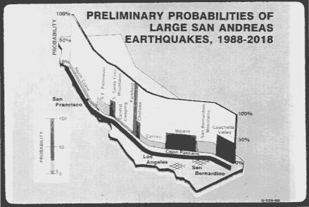
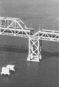

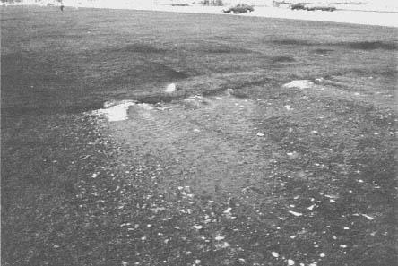
FIGURE 1-13 Liquefaction in the Marina District.
Liquefaction and shaking played a role in the collapse of the bridge in the Salinas River valley (Figure 1-14). The pilings of this bridge had some problems at the top and also some movement at the base. Figure 1-15 shows the second deck and the bottom deck of the multistory Nimitz Freeway and illustrates the collapse of the pilings that held up the second deck.
In the Santa Cruz Mountains area, landslides and slumping were very common. Chasms formed in the ground (Figure 1-16), and in some places shaking was intense enough or ground failure occurred to cause the collapse of structures (Figure 1-17). Generally, wooden-frame houses do fairly well in the event of earthquakes. Usually unreinforced masonry structures have the most difficulties.
The areas of damage in the Loma Prieta earthquake in the San Francisco Bay area were largely predicted. Figure 1-18 illustrates the areas where maximum earthquake intensity was predicted. As shown, the Marina District, where a lot of the Loma Prieta damage occurred, was identified as an area of predicted violent shaking. This map replicates the effects that were seen in the 1906 San Francisco earthquake. It is quite possible for engineers and geologists to identify where ground shaking will be most intense from earthquakes, which is generally on unconsolidated sand or mud. Bedrock is a better place to be in the event of an earthquake. The importance of Figure 1-18 is that it shows that it is possible to map an area based on engineering and geologic studies in order to identify the most vulnerable areas.
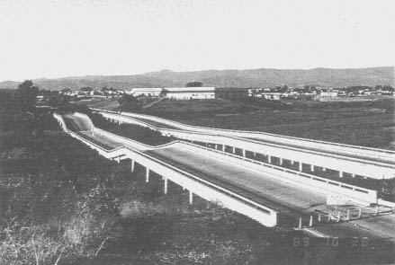
FIGURE 1-14 Collapsed bridge in Salinas River valley.
One area of concern in California is the Hayward fault in the Bay Area. The USGS recently reanalyzed the threat of earthquakes along that segment and have raised the probabilities of earthquakes along the Hayward fault. A lot of critical structures are located along the Hayward fault. Schools are nearby, and lifelines cross this area; therefore, it will require attention in the next several years.
Focusing on the earthquake history in the rest of the country, Figure 1-19 shows earthquakes of intensity 7 or greater that are known in historical time. They are fairly broadly distributed; however, there are concentrations. One of the biggest concentrations is in the central Mississippi Valley area, in the area of the New Madrid seismic zone, which has been—over the last several hundred years and even recently—the most active seismic area in the eastern United States. There has also been a lot of activity in the St. Lawrence River valley area.
As recently as the last 15 years, there was no geologic explanation for the cause of the New Madrid earthquakes. But now, thanks largely to the research that has been carried out under the National Earthquake Hazard-
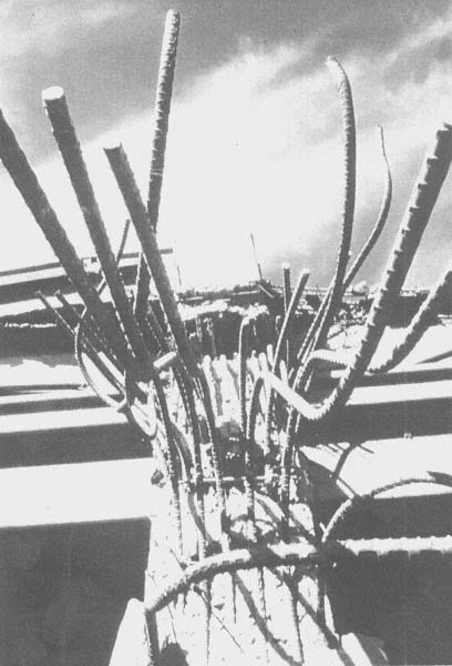
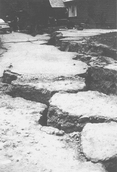
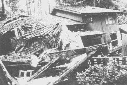
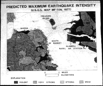

FIGURE 1-19 Earthquakes of intensity > VII or felt area > 450,000 km2.
Reduction Program, we have a fairly good understanding of the cause of these earthquakes.
As stated at the beginning of this chapter, earthquakes in the East affect a far greater area than earthquakes of corresponding magnitude in the West. Figure 1-20 shows the areas of intensities 6 and 7 for the New Madrid earthquake of 1811, the Charleston earthquake of 1886, the San Francisco earthquake of 1906, and the San Fernando earthquake of 1971. The 1906 earthquake had a magnitude of about 8.25, and this particular New Madrid earthquake also had a magnitude of near 8, indicating that about the same amount of energy was released. But it is clear how much greater an area was affected by the eastern earthquake. The reason for this is the crust of the earth in the East is older and colder and less fractured, or at least the fractures are healed somewhat relative to those in the West. The West is young and active and dynamic—referring to geology, not people—so seismic waves are more attenuated in the West compared with the East. If you ring the crust in the East, the waves propagate much more efficiently and to a greater distance than in the West. The same is true of the Charleston earthquake, which was on the order of magnitude 7, and the San Fernando earthquake, which was more like 6.5; but the Charleston earthquake affected a much larger area. This means that although earthquakes occur less often in the East, they affect a greater area when they do occur.
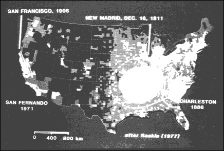
FIGURE 1-20 Felt areas of some large U.S. Earthquakes.
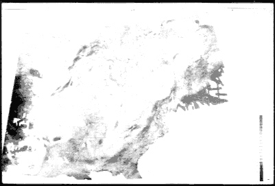
Figure 1-21 shows the terrain (elevations) in the eastern United States. There is a depression in the crust of the earth that extends into southern Illinois and Indiana, which is anomalous in the East.
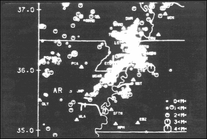
Figure 1-22 illustrates the attraction of gravity in the East. There is a high gravitational attraction relative to elsewhere, extending into the central Mississippi area, which also indicates a somewhat anomalous crust of the earth in the Mississippi Valley area. The earthquake activity in the New Madrid area occurs along some fairly narrow boundaries running through northeastern Arkansas, into the Boot Heel of Missouri.
The bands of seismic activity shown in Figure 1-23 define faults that are associated with specific geologic features. In addition to the earthquakes that occurred in 1811 and 1812 in this area, there also have been other earthquakes since then. In 1843 in northeastern Arkansas, there was a magnitude 6.5 earthquake; and in 1895, there was a magnitude 6.8 earthquake (very close in magnitude to the Loma Prieta earthquake) in the area of Charleston, Missouri. Since 1895 there has not been a 6 or greater magnitude earthquake in this particular area. There has been a long period of time without significant earthquake activity in the New Madrid zone, but it is still active. It just has not ''popped off'' lately.
Figure 1-24 is a map of the magnetic field of the New Madrid region. A band of subdued magnetic field runs along this trend. The earthquake

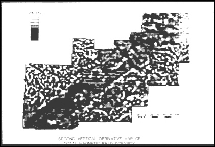
activity runs right down the middle of the band, then crosses it and runs along its northwestern boundary. This band of activity is caused by a down-drop of about a mile of the crust of the earth. It is much like a keystone in an arch: If you stretch the arch a little bit, the keystone drops down. In this case, the keystone dropped about 500 million years ago when the crust of the earth in this area was stretched. Since then, the stresses that have been caused by the flexing of the North American plate have repeatedly jostled the keystone and created a new geologic structure, but it is basically the reactivation of the keystone that is causing earthquake now.
In 1886, a magnitude approximately 7 earthquake occurred in the Charleston, South Carolina, area and caused significant damage. It also caused liquefaction, land deformation—including a deformation that bent railroad tracks—and fairly extensive sand-blow activity. These blows are very useful, because they show evidence of prehistoric earthquake activity. These are very common in the New Madrid area, and more of them have recently been found in the Charleston area. Also some were found recently in the Wabash Valley area between Indiana and Illinois, which indicates earthquake activity in that area.
The earthquakes along the eastern margin of the United States are very poorly understood, but they probably have to do with the formation of the Atlantic Ocean. There is a line of earthquake activity that runs right down the middle of the Atlantic Ocean. In the past, the continents were joined together. Because of hot material coming up from the inside of the earth, the continents drifted apart to form the Atlantic Ocean. The scars that were left when those continents drifted apart probably established the fault lines that are being reactivated now to cause the earthquakes along the Atlantic margin.
When it comes to assessing the economic impact of earthquakes and designing various measures for earthquake mitigation, it is very important to know about earthquake probabilities. These probabilities can be estimated from geologic and seismologic evidence. This evidence has been referred to at various locations in this chapter. In California, that type of data is in fairly good abundance. Estimates have been made of the likelihood of earthquakes along various parts of the San Andreas fault; these estimates have been published. These probabilities are of the nature of a 30 percent chance of a certain-sized earthquake occurring in the next 30 years.
Studies on the economic impact of earthquakes in the eastern United States and the midcontinent, are much further behind. There have been estimates based on fairly fragmentary data. There are estimates for the New Madrid area, giving numbers like a magnitude 8 earthquake every 1,000 years or so. But these estimates are very unreliable at the present time. Also, there must be some geologic phenomena there that can be found to improve those estimates.
Overall, over the next 10 to 20 years, there will be new data that will greatly improve our estimates of earthquake likelihood. These data can be used, together with engineering and other types of efforts, to greatly reduce
the vulnerability of earthquake damage and the threat to the country from earthquakes.
GENERAL DISCUSSION OF CHAPTER 1
QUESTION: When the New Madrid zone is projected to the northeast, there is a basis for projecting it all the way to the Buffalo area. What is the likelihood of earthquakes further north?
DR. HAMILTON: There is a hypothesis that the earthquake activity in the St. Lawrence Valley area in the northeast could be projected all the way down to the New Madrid area. There is a rough alignment of epicenters along that trend. So when a seismologist looks at the dots on an epicenter map, it is pretty easy to draw a line through them. Geologists, however, get very agitated when that is done because they look at the geologic structures and say the continuity in the structures is just not there. Therefore, it has to be regarded as an unproven hypothesis.
Even looking in the New Madrid area, geologically there is no continuity in the faults between the Wabash Valley area and the Mississippi Embayment area. All of the faults that have been mapped terminate. There is a discontinuity along another fault system that runs east-west, so it is even conjectural whether the structures in northeastern Arkansas can be connected with those between Indiana and Illinois. Lacking a convincing case that these structures can be connected, a reliable projection of what significance New Madrid activity might have further to the northeast cannot be made.
QUESTION: What is the story behind the predictions of the Loma Prieta earthquake?
DR. HAMILTON: In the sense that the term "prediction," is normally considered, that earthquake was not predicted. There was a report published in 1988, the year before the earthquake, that identified that section of the fault as having a high probability for future earthquake activity. A probability of 30 percent was given for an earthquake in the next 20 years, but in no sense was that section identified as having a high likelihood of an earthquake in the near term. Therefore, it would be what one might call a long-term earthquake prediction.
The evidence for that prediction was largely geologic and seismologic in that it was a place where there was a gap in the seismicity. This was a case where the stresses were building up and were not being released. Also, based on geologic and surveying data, scientists knew that there was a slip deficit that sooner or later had to go. It was a case where the area was identified as a likely place for an earthquake, but there was no near-term prediction.
After the earthquake, there was some evidence that suggested that maybe there were some phenomena beforehand. An instrument run by a professor at Stanford, which monitored electromagnetic phenomena, had recorded anomalous activity a few hours and days before the earthquake. But, there is no reliable basis for a short-term earthquake prediction. However,
there is a good basis for identifying potentially dangerous areas based on longer-term studies.
QUESTION: Has there been a probability associated with a New Madrid earthquake?
DR. HAMILTON: There have been some recurrence estimates given, and there have been some probabilities published, but they are not regarded as being very reliable. Generally, a magnitude 6 earthquake in that part of the country should be expected every several tens of years or so. A magnitude 8 earthquake might occur every 500 to 1,000 years.
QUESTION: Figure 1-18 showed the high probability of earthquake likelihood on the east side of the San Francisco Bay. Do those areas also indicate something about damage?
DR. HAMILTON: Yes. Figure 1-18 was a map of predicted violent ground shaking that the USGS published in 1977 and illustrated that there was a lot of damage in the Marina area. Also, the area where the Nimitz Freeway collapsed had been identified as an area of poorly consolidated material. Of course, there was not a lot of damage in the East Bay, but this earthquake was a long way from the East Bay. If an earthquake occurred in the Bay Area, particularly along the Hayward fault, a lot of damage in areas of poorly consolidated material could be expected.


