
3
NATIONAL SPATIAL DATA INFRASTRUCTURE
EVOLUTION
In the past few decades, there has been an evolution of how data and information are perceived in the context of an information society and in the capabilities of handling spatial data. The changes have been remarkably parallel.
The characteristics of data and information have progressed from a discipline orientation to a mission orientation and finally to a problem orientation (American Library Association, 1978). All three orientations currently exist and are interrelated. The disciplinary orientation largely concerns physical measurements often of a narrow technical nature (e.g., hypsography). The mission orientation represents the organization of data and information required for a specific job (e.g., building a weapon system or assessing a natural resource). The problem orientation draws on data and information from the disciplinary and mission orientations but is distinguished by the need to integrate information from a variety of sources primarily for public policy formulation and decision making. The characteristics of these three orientations are given in Table 3.1.
In a similar context, efforts to build computer-based spatial information systems can also be viewed in three stages. The initial stage dates back to the early 1960s, evolved through a second, and is now entering a third (McLaughlin, 1991). There is no simple boundary separating stages. The dates given below are somewhat arbitrary but they represent major shifts in the general environment.
TABLE 3.1 Characteristics of Data and Information Orientations
|
Orientation |
Information Content |
Target User Group |
User Sophistication |
|
Discipline Oriented |
''Truth of science," mostly dealing with physical systems |
• Members of the discipline involved • Generally individuals heavily committed to disciplines |
Very high technical sophistication; communicates to a particular technical elite |
|
Mission Oriented |
The above; also truth of science as it applies to technological objectives, ways in which physical systems can be manipulated and controlled for practical purposes |
• Technologists, engineers, and applications people • Team members committed for multiyear periods |
Moderate to high technical sophistication; needs to communicate across disciplines |
|
Problem Oriented |
All of the above; also wisdom and pragmatics that work in contexts of uncontrollable open systems involving human as well as physical dynamics; includes legal, sociological, economic, and demographic information and important social value inputs |
• Large segments of the public in state and local governments and all types of industries, communities, planners, conservationists, bureaucrats, and policy makers at all levels • Transient, relatively short-term users |
Very low to high technical sophistication; needs to communicate across major cultural groups; heavy involvement of nontechnical professionals and political groups |
|
Source: American Library Association (1978) |
|||
Stage I (circa 1960—1980)
During this first period there was much experimentation and a genuine effort to develop a new paradigm for managing spatial data. With its focus on research and development, this period saw the first use of computers in surveying and mapping, the first efforts in automating land records, and the first attempts to build urban and regional information systems. The inspiration largely was driven by the public value (or need) of spatial data rather than the technology or commercial value of the data.
There was a broad vision of an information society, including the inherent power of spatial data systems to help resolve land issues and to enable greater citizen participation in decision making. In government and university laboratories, the first GIS software was developed to integrate the variety of information required for regulation and land-use planning. State systems in Minnesota and elsewhere evolved in response to the environmental agendas of the late 1960s and early 1970s. Furthermore, new concepts, such as the multipurpose cadastre, emerged for organizing land-related activities around shared information. The vision cut across disciplinary boundaries and the early years were characterized by a strong interest in integration and cooperation.
Stage II (1975—2000)
If the first stage was marked by innovation and a broad vision, then the second stage might be described as a retreat. This is the period in which computer-based spatial information systems have come into their own for administration, facilities management, and planning. Governments at all levels are making large investments in data base development. But for the most part these accomplishments are occurring within traditional institutional models (e.g., line departments automating their established activities). Far too often, the vision of the integrating powers of the new technology and the potential devolution of power to the people has been lost.
A critical feature of this period has been the rapid emergence of commercial GIS and digital mapping software, and by the mid-1980s a major vendor-driven market had been established. The vendors increasingly set the agenda. The tools of the trade began to dominate the proliferation of conferences, and the question of why was replaced with how. No organization has wanted to be left out but few have had innovative ideas
about using the tools they purchased. Despite emphasis on graphics and spatial analysis (especially by academics), the predominant interest has been in textual data and in simple, straightforward query applications of the spatial data. There have been important technological improvements (especially in hardware) but many of the basic concepts date back to the first stage of research and development.
Stage III (1990 and beyond)
Now that there have been major investments in technology and the process of building data bases has begun, there is an opportunity to regain a sense of purpose. Infrastructure is different from information systems: the emphasis is shifting once again from information technology to information and its use in society. As the technology becomes commonplace (shown by the use of terms such as appliance), the emphasis on the simple query tools will diminish. Information will become part of the background as communicating and extracting knowledge become increasingly important.
The period we are gradually moving into will be dominated by integration and applications. The focus will be on linking data bases into distributed spatial information networks and on developing application software and decision-support tools to more effectively exploit the available information. What has been perceived as having commercial value in the information industry will change with the diffusion of value-added products and services. Social issues such as rights of privacy and access, which have mostly been given lip service, will require real solutions. New institutional arrangements, alluded to in Stage I and largely dismissed in Stage II, will finally begin to emerge. Driving this movement will be a renewed concern about the effective development and management of our land and marine resources and the relation to the larger environmental agenda.
CONCEPT
We are beginning to see coordination, linkages, and information "flows" that are made possible by the application-neutral character of digital spatial data and by the power of the computers and networks used to process and distribute the data. There has been a technological
revolution, but the institutional evolution required for us as a nation to take advantage of it has not yet occurred. The balance of this report will examine this discrepancy in detail to effect what we will argue is much-needed change.
In summary, the National Spatial Data Infrastructure is the means to assemble geographic information that describes the arrangement and attributes of features and phenomena on the Earth. The infrastructure includes the materials, technology, and people necessary to acquire, process, store, and distribute such information to meet a wide variety of needs.
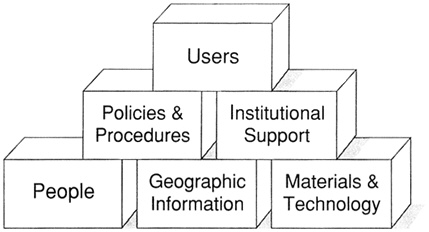
Figure 3.1
NSDI building blocks.
Although spatial data are necessary for a spatial data infrastructure, they are not sufficient. Of equal importance are the individuals, institutions, and technological and value systems that make it a functional entity, one that serves as a basis for much of the business of a nation.
It should also be made clear that the word national, as used in NSDI, does not refer exclusively either to the federal government or to data coverages for the whole country. The MSC uses the term as applicable to the needs of the nation as a whole, in the interests of the public and private sector organizations, and individuals nationwide who provide the financial resources to support it.
Finally, we must emphasize that there is a national spatial data infrastructure in existence. It is an ad hoc affair because, until very recently, no one has conceived of it or defined it as a coherent entity, and indeed it has not been very coherent or coordinated. It is not the task of the MSC (or of anyone else for that matter) to create a national spatial data infrastructure. We want merely to point out its existence, identify its components and characteristics, assess the efficiency and effectiveness with which it functions to meet national needs (particularly at the federal level), and make recommendations that might make it more useful, more economical, more effective, better-coordinated, and robust. Several investigators have shown that investments in using GIS are normally repaid by the long-term benefits and that greater efficiencies are realized (Brown, 1990; Gillespie, 1992). In addition, there could be a significant reduction in the cost of operation of GIS if existing data were shared, thus reducing duplication of efforts of data collection.
Information flow, particularly in the spatial data infrastructure, should be seen as critical to the maintenance of a competitive position for the United States in an increasingly international economic arena. The concept of a spatial information infrastructure has recently been addressed in a number of countries, including Australia, Canada, New Zealand, and the United Kingdom (Newton et al., 1992; Rhind, 1992).
Once the national spatial data infrastructure is recognized, its functions and malfunctions can be examined in detail. The MSC found two major categories of obstacles to efficiency and change. First, there are serious impediments to coordination and efficiency. Traditional arrangements for creating, disseminating, using, and paying for maps do not necessarily work in the spatial data era. Consequently, failure to recognize information creation and distribution as legitimate parts of the mission of federal agencies often creates enormous waste for the nation's taxpayers.
Second, there is no system of incentives to direct funding and capability, both public and private sector, in the direction of more coordination and greater efficiency. The creation of incentive systems will, among other things, make it attractive and perhaps even essential for the public and private sectors to work together in the spatial data infrastructure to a degree undreamed of in the past.
REFERENCES
American Library Association (1978). Into the Information Age: A Perspective for Federal Action on Information, American Library Association, Chicago, 134 pp.
Brown, K. (1990). Local Government Benefits from GIS, PlanGraphics, Inc., Lexington, Kentucky.
Gillespie, S. R. (1992). The value of GIS to the federal government, in Proceedings: GIS/LIS '92 Annual Conference and Exposition, Anaheim, California, pp. 256–264.
McLaughlin, J. (1991). Towards a national spatial data infrastructure, in Proceedings of the Canadian Conference on GIS, Ottawa, March 1991, pp. 1–25.
Newton, Zwart, and Cavill, eds. (1992). Networking Spatial Information Systems, Belhaven Press, London.
Rhind, D. (1992). The information infrastructure of GIS, in Proceedings, 5th International Symposium on Spatial Data Handling, International Geographical Union Commission on GIS, August 3–7, 1992, Charleston, South Carolina, pp. 1–19.


