
6
SPATIAL DATA AND WETLANDS
INTRODUCTION
One of the objectives of this report is to identify what could be done better or more efficiently if the content, accuracy, organization, and control of spatial data were different. To answer this question it is important to understand the complexity of such an infrastructure, including the spatial data themselves. Spatial data consist of digital representations of geographic objects or features on the surface of the earth including tangible man-made objects such as roads and administrative features such as land ownership parcels that are part of the rural and urban fabric discussed in the previous chapter. An equally important part of a spatial data base, however, consists of features that occur as the result of physical, chemical, or biological processes. To focus on those naturally occurring features, the MSC studied existing programs that generate spatial data bases of wetland features. Wetlands were chosen because they represent environmental aspects of the Earth that need to be delineated, measured, represented, analyzed, and displayed quite differently from man-made objects, such as streets. Wetlands were also chosen because they are of considerable national interest and debate. For example, it can be argued that a federal mandate for ''no net loss" of wetlands relies on a consistent spatial data base. Given the fact that wetland data are collected in numerous federal, state, and local agencies as well as several private institutions, the MSC believed that a case study with a focus on wetlands would provide an excellent example of the needs and challenges facing the development and implementation of a robust NSDI.
Maps are graphical models or simplified views that represent the distribution of a collection of features on the Earth's surface. To provide a consistent spatial data representation of a feature there must be agreement on how to classify it, how to delineate it, the criteria for inclusion, valid attributes to assign to it, and the appropriate way to symbolize it. In the previous chapter we examined the federal response to the creation and maintenance of a data base of street centerlines for the nation. Such a file is composed of a relatively unambiguous and easily identifiable set of geographic features. These features are very tangible and can be graphically represented as a set of line segments that form the links of an integrated network. For example, while differences of opinion exist among agencies regarding the appropriate classification of roads and the set of attributes that should be assigned to them, the task of delineating and representing them is straightforward and can be achieved from a wide variety of source materials. In contrast, the natural environment presents a much more complex set of challenges. Naturally occurring features such as wetlands are not only difficult to classify, but they also have poorly defined edges, tend to change through time, appear and disappear at different scales, and often can only be delineated with field work and skilled interpretation based on specialized source materials, such as color infrared photography. Furthermore, the areal extent or quantity of natural features has important ramifications for economic policy, land use controls, taxation, and environmental concerns.
To monitor whether the mandate for no net loss of wetlands is being followed, there needs to be accurate data regarding the spatial distribution of existing wetlands through a time interval. In other words, there is a need for a series of wetland maps, and there really is no other acceptable alternative. Armed with GIS and the appropriate series of digital maps, it would be relatively easy to evaluate the distribution of wetlands. For example, an important tool of modern GIS is the ability to measure the area of features. In fact once a wetland area is encoded into the system, its area is automatically calculated. In a digital world it is also easy to automatically compare wetland maps at different times to measure and to display changes.
Unfortunately, the fact that the tools exist to monitor wetland change does not mean that governments have been able to implement such systems. From a mapping science perspective several problems exist. The most fundamental issues are classification, delineation, resolution, and representation of wetland data. Although the FGDC is beginning to address
the problems, we as a nation have not collectively agreed about what wetlands are, how to identify them, or how to encode them. The problems are difficult because wetlands themselves are ambiguous entities. Although wetlands are often included as a category of land cover, they actually are a condition of various categories of land cover (e.g., forested wetlands) and are commonly defined in terms of soil types. The wetland classification problem is exemplified in Table 6.1, which lists seven different wetland definitions. Although it is possible for the scientific and regulatory communities to reconcile differences in definitions, once we agree on what constitute wetlands, they still have to be identified on an acceptable mapping base. This task is difficult because the boundaries are usually transitional, without abrupt or definite edges. These fuzzy boundaries are rather elastic and can migrate with seasons or with climatic changes. The result are zones of varying transition.
Another issue involves the optimum way to represent wetland features in a digital spatial data base. For some programs and analytical needs, wetland data are stored as a cluster of uniform grid cells. Such raster systems often portray wetlands derived from digital image data captured by satellite or airborne photography. In most mapping and inventory systems used for planning and regulation, a wetland feature is represented as a homogeneous closed polygon. Within the existing programs there are several alternatives for the creation, maintenance, and distribution of a wetland data base. The possibilities include:
-
a layer of polygonal areas that would replace the swamp symbols on the USGS 1:24,000 DLG versions of the topographic quadrangle maps;
-
a series of polygons of the FWS 1:24,000 NWI maps;
-
hydric soil polygons on the SCS soil surveys;
-
a subset of wetland polygons that share boundaries with upland areas on a national land-use and land-cover data base;
-
a digital layer of a proposed quarter-quad (1:12,000) orthophotography program (SCS, ASCS, and USGS);
-
a digital layer on a federal, state, or local agency cooperative program such as the Maryland digital orthophoto quarter quad mapping and wetland inventory program; and
-
a series of polygons on maps (digital or not) from the various state and local wetland mapping programs.
TABLE 6.1 Seven Examples of Wetland Definitions
|
Emergency Wetlands Resources Act of 1986 (PL99–645) |
|
The term "wetland" means land that has a predominance of hydric soils and that is inundated or saturated by surface or groundwater at a frequency and duration sufficient to support, and that under normal circumstances does support, a prevalence of hydrophytic vegetation typically adapted for life in saturated soil condition. |
|
Swampbuster Provision, Food Security Act of 1985 (PL99–198) |
|
The term "wetland," except when such term is part of the term "converted wetland," means land that has a predominance of hydric soils and that is inundated or saturated by surface or groundwater at a frequency and duration sufficient to support, and that under normal circumstances does support, a prevalence of hydrophytic vegetation typically adapted for life in saturated soil conditions. |
|
U.S. Fish and Wildlife Service (Cowardin et al., 1979, adopted 1980) |
|
Lands transitional between terrestrial and aquatic systems where the water table is usually at or near the surface or the land is covered by shallow water. For purposes of this classification, wetlands must have one or more of the following three attributes: (1) at least periodically, the land supports predominantly hydrophytes, (2) the substrate is predominantly undrained hydric soil, and (3) the substrate is nonsoil and is saturated with water or covered by shallow water at some time during the growing season of each year. |
|
U.S. Environmental Protection Agency (40 CFR 230.3, Federal Register, 1980) and the U.S. Army Corps of Engineers (33 CFR 328.3, Federal Register, 1982) |
|
Those areas that are inundated or saturated by surface or groundwater at a frequency and duration sufficient to support, and that under normal circumstances do support, a prevalence of vergetation typically adapted for life in saturated soil conditions. Wetlands generally include swamps, marshes, bogs, and similar areas. |
|
State of Wisconsin (NR 115.03 WAC) |
|
Those areas where water is at, near, or above the land surface long enough to be capable of supporting aquatic or hydrophytic vegetation, and which have soils indicative of wet conditions. |
|
State of Connecticut (22a-38 Connecticut General Statutes) |
|
Wetlands means land, including submerged land, which consist(s) of any of the soil types designated as poorly drained, very poorly drained, alluvial or flood plain by the National Cooperative Soils Survey, as may be amended from time to time, by the Soil Conservation Service of the U.S. Department of Agriculture. |
|
State of California (California Coastal Act of 1976, Section 30121) |
|
Lands within the coastal zone which may be covered periodically or permanently with shallow water and include saltwater marshes, freshwater marshes, open or closed brackish marshes, swamps, mudflats, and fens. |
Mapping wetlands presents an interesting set of challenges. At the same time, our federal policies require that the problems be addressed. Therefore, the MSC examined the current roles of various institutional entities in the use and sharing of geographic information pertaining to the nation's wetlands. During the study, we found that policy issues dominated the consideration of wetlands; Appendix A treats these issues in additional depth. Wetlands illustrate how the scientific and resource planning and management communities go about the identification, classification, and delineation process in contrast to how a society goes about the difficult process of deciding what it is willing to regulate. Similar examples of national interest could be the distribution and condition of endangered species habitat or an assessment of biodiverse land areas.
EVALUATION PROCESS
Public Interest in Wetland Protection
One study (Dahl, 1990) estimated that 53 percent of the nation's original wetlands had been lost by the mid-1980s. Public interest in protecting and enhancing the remaining 103.3 million acres of wetlands emerged at the state and local level before the federal level. Congressional interest began in the late 1970s. In 1977 the Federal Water Pollution Control Act of 1972 was amended; it is commonly known as the "Clean Water Act." This act prohibits the dredging and filling of "jurisdictional"
wetlands without a permit from the Corps of Engineers (COE). In 1985, and again in 1990, Congress expanded interest in wetlands by including economic incentives for farmers to eliminate "swampbusting" of wetlands in farmed areas. In 1986 the FWS was authorized to conduct a statistically based analysis of the status of trends of wetlands and produce NWI maps for the conterminous United States by 1998.
In 1988 the nations interest in wetland protection was amplified by President George Bush when he ran for election in support of the Conservation Foundation's recommendation of "no net loss" for the remaining wetlands. In parallel with this national focus and interest, 27 states now have some form of wetland protection regulations. In essence the debate over wetlands has now moved from a question of whether wetlands should be protected to a question of how much protection should be afforded the remaining wetland resource (Zinn and Copeland, 1992).
This question of how much or what subset of the overall wetland resource needs national attention and regulation, and a major debate is under way between wetland protection advocates and private land owners. The environmental and wetland advocates have concluded that "a major impediment in maintaining, enhancing, and restoring wetland resources is the lack of a coordinated, consistent approach among federal, state and local governments" (Zinn and Copeland, 1992). This lack of a coordinated and consistent inventory mapping and analysis capability is at the crux of public debate (see Appendix A). Without a reconciliation of the overlaps in these authorities and resultant data collection procedures, the ability to incorporate spatial data and information about the nation's wetlands into an NSDI remains problematical.
Lack of a Collective Perspective
It can be concluded that the need to bring forth a common view on the location, status, and trends of wetlands and the subset of those of national interest remains as the primary impediment to broad public and private support and the eventual criteria for spatial data about wetlands. For example, the owners of wetlands say "that protection efforts have gone too far" (Zinn and Copeland, 1992). A similar concern was reported in USA Today when President Bush was quoted "We ought to stay with our objective of 'no net loss'. . . but we don't want to overdefine what a wetland is" (Benedetto, 1992).
In essence, wetlands described and mapped as part of NWI and the Food Security Act (FSA) should be identical in definition and boundary delineation. Jurisdictional wetlands or that subset to be regulated by the COE and the EPA need to be nestable within the NWI and the FSA classification system. At present, jurisdictional wetlands are determined case by case by the COE, with veto responsibility assigned to the EPA. Because the COE conducts only case-by-case analysis, there are no maps available to alert those who might be affected by these jurisdictional wetlands. As stated by the Executive Director of the Association of Wetland Managers: " . . . in contrast [to the COE] virtually all state and local governments map wetlands as part of the regulatory process" and " . . . this lack of a consistent map base results in a federal program subject to varying interpretation by individual regulators." As a result, " . . . the regulatory process is difficult and time consuming. . . . Moreover, both delineating a wetland and applying for a permit are costly" (Kusler, 1992). (Niemann, 1992, estimated an annual cost of about $100 million.)
As in the previous paragraph, the MSC finds that without a reconciliation effort (among federal, state, and local regulatory activities) leading to a composite national view, incorporation of spatial data and information about the nation's wetlands into an NSDI remains problematical.
Impediments
Four potential impediments were identified that limit in various forms the implementation of a national wetland data and information resource. These impediments are: technical, legislative, institutional, and economic. These potential impediments were compared with 11 data collection and management recommendations prepared by the Interagency Wetlands Task Force (Table 6.2). The results of this analysis further demonstrate the difficulty of developing a national wetland information resource. The problems include inconsistent interpretations of wetlands between NWI and FSA maps even though the definitions are identical.
Other technical issues emerged, such as the technical specifications and data sources for wetland information. NWI delineations involve aerial photographic interpretations; FSA determinations involve the use of soil maps, aerial photographs, on-site evaluations, and more recently experimentation with satellite imagery. COE/EPA determinations of jurisdictional wetlands are handled case by case. This complexity of overlapping man
TABLE 6.2 Impediments to a National Wetlands Spatial Data Infrastructure
|
Recommendations (Wetlands Inventory Report) |
Technical Impediments |
Legislative Impediments |
Institutional Impediments |
Economic Impediments |
|
1. Complete NWI maps (FWS) |
• Nonautomated product • No image backdrop (not essential but would enhance product usefulness) • Existing satellite resolution limits usefulness |
• No authority to use FWS resources to automate (does not impede 1986 emergency mandate but restricts pace of automation and robustness) |
• Other federal, state, and local agencies are duplicating wetland products |
• Increased funding required |
|
2. Integrate statistical analyses (FWS, SCS) |
|
• Duplicative and nonintegrated efforts limit full value of wetland quantity and quality data collected |
• EPA's EMAP is not includeda |
|
|
3. Implement wetland change program for coastal wetlands (NOAA) |
• Limited automated and compatible data sets restricts implementation |
• Authority limited to wetlands associated with coastal areas |
• Absence of other agency interests (e.g., FWS, SCS, and EPA) results in duplication |
|
|
4. Coordinate and integrate national wetland permit tracking system (COE-RAMS) |
• Relationship to GRASS is not operational |
|
• Long-term relationship with state permitting is unclear |
• Increased funding required |
|
Technical Impediments |
Legislative Impediments |
Institutional Impediments |
Economic Impediments |
Recommendations (Wetlands Inventory Report) |
|
5. Develop automation standards for wetland information (FWS) |
• Usefulness of SDTS is unclear |
• No standard setting authority exists for automated wetland data |
• Success of FGDC not assured |
|
|
6. Coordinate and integrate wetland mapping programs (FWS, SCS) |
• Lack of compatibility between wetland data bases (1:24,000, NWI) in cartographic form with SCS (1:7,920) photographic baseb • Interface with NWI maps and the SCS orthophoto program are not clear |
• No legislative requirement to reconcile and integrate collection platforms, classification systems, and data sets |
|
|
|
7. Establish a National Wetlands Digital Data Base (FWS) |
• Lack of automated data sets limits analysis • Inclusion of grade B data • Mixing data sources quickly • Maintaining attribute integrity |
• Until recently, no authority to use FWS resources to automate |
|
• Until recently, only available resources for automation mere 100% user-pay dollars |
|
8. Expand mapping and inventory systems to include functional value of wetlands (EPA, NOAA) |
• Absence of reliable predictive models limits usefulness • Absence of low-cost high-resolution satellite imaging limits applicability |
|
• Relationship with other mapping and statistical interests is duplicative (e.g., SCS, NWI) |
|
dates and various analytical approaches compounds the data integration problem.
All of this complexity speaks to the need for a strategic approach for those responsible for administering wetlands policy. Elements of such a strategic approach could include the following:
-
integrating and coordinating NWI and FSA wetland programs and nesting COE jurisdictional wetlands within NWI and FSA,
-
developing standards for digital wetland information,
-
fully implementing the multiagency national orthophoto program (both digital and hard copy products)
-
integrating statistical analysis of the status and trends of the nation's wetlands, and
-
integrating and coordinating the various ongoing state and local wetland mapping programs and nesting these classifications within the NWI.
The ability to implement such a strategy will require a concerted effort. The FGDC should consider facilitating such an effort.
Wetland Information Diffusion Model
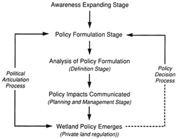
To understand the current status of spatial data products that support decisions concerning the nation's wetlands, it is useful to examine the changing context of wetland information. Wetland data and information that initially were collected for descriptive and planning purposes are increasingly being used for regulatory purposes, which places different requirements on the information. The MSC presents these changing requirements in terms of information diffusion models. The description of an evolutionary model could serve those who will become responsible for such other natural phenomena of national attention. Figure 6.1 portrays an information diffusion model that explains and/or predicts the state and condition of wetland information. Five information stages were identified:
-
awareness stage: the process of collecting and analyzing information to gain public support;
-
policy formulation stage: the process of using information to gain legislative support and define intent;
-
definitional formulation stage: the process of developing administrative rules that are dependent on reliable (repeatable) measures;
-
planning, management, and analysis stage: the process of mapping wetland entities for both internal management and also to communicate the location and distribution of these regulated and non-regulated wetlands; and
-
private land regulation stage: the process of imposing stated public policy on privately held lands.
What the model shows is that as the process moves into the last stage—regulating of private land—information requirements become more specific and demanding. Wetland entity mapping becomes integrated with property boundaries. Digital data collection and GIS technology and automated land records become important factors.
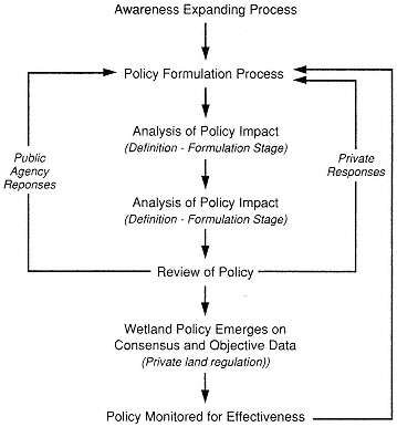
This evolution of wetland information diffusion is in a state of flux as portrayed in Figure 6.2. As this definitional process affects land development rights on privately held land, the public debate accelerates. This interaction, even though troublesome to the information community, in effect constitutes the current implementation process. As a result we have a difference between the policy of no net loss and the political process by which society and private land owners are determining what they are willing to endure.
Finally, in retrospect, if the information community had been in a position to implement a national wetland information resource before and in anticipation of the private regulation stage, it is likely that much of the present technical chaos, overlapping information collection mandates, and institutional inaction could have been substantially reduced. Therefore, the MSC finds that consistent and clear policy along with an understanding of the diffusion of information are required if the wetland components of the NSDI are to be strengthened,
CONCLUSION
We conclude that the FGDC, through its Subcommittee on Wetlands, needs to reconcile the technical and institutional issues that impede our nation's ability to efficiently and effectively map, assess, monitor, and automate wetland information. To accomplish this reconciliation, the FGDC needs to exercise its coordination authority that
resides in the OMB revised Circular A-16 and to develop and implement a wetland information diffusion model that is responsive to both policy and regulatory requirements. Many of the necessary reconciliation efforts are outlined in Appendix A.
REFERENCES
Benedetto, R. (1992). Bush pledges more for Forest—But other messages are mixed, USA Today, June 1, 1992.
BEST/WSTB (1992). Review of EPA's Environmental Monitoring and Assessment Program (EMAP): Interim Report, Board on Environmental Studies and Toxicology (BEST) and Water Science and Technology Board (WSTB), National Research Council, Washington, D.C., 25 pp.
Kusler, J., (1992). Wetland delineation: An issue of science or politics, Environment 34 (2).
Niemann, B. J., Jr. (1992). Geographical Information Systems (GIS) Technology: Modernizing the Wetland Permitting Process, CRSS Architects, Inc., Houston Texas.
Want, W. L. (1991). Law of Wetlands Regulation, Clark Boardman Co., Ltd., New York.
Zinn, J., and C. Copeland (1992). Wetland Issues in the 102nd Congress, CRS Issue Brief, Congressional Research Service, The Library of Congress, Washington D.C.


