
3
DEVELOPMENT AND HISTORY OF MOUNT RAINIER
This chapter provides a brief overview of the development of Mount Rainier from a regional perspective. It also outlines the detailed studies needed to assess potential hazards to life and property in the areas surrounding the volcano. The evaluation of hazards at Mount Rainier requires an understanding of the geologic history of the volcano and the surrounding region. Study of the geologic history is important because it is a guide, though admittedly imperfect, to what may happen in the future. A regional perspective is necessary because regional effects such as ground shaking due to large earthquakes on distant faults could have significant local consequences, as discussed in Chapter 2, and because the impacts of potential hazards such as debris flows could extend several tens of kilometers downstream of the edifice. The history of the volcano during the Holocene is particularly important, because, as explained below, this history is probably most directly relevant to assessing future hazards.
Much of the recommended work at Mount Rainier can be linked to ongoing research programs of federal, state, and academic scientists that address the broader geologic analysis of the Pacific Northwest. For example, a major investigation of crustal structure is planned in 1995-1996 by the U.S. Geological Survey (USGS) Deep Continental Studies Program along an east-west corridor extending from the Pacific coast to the Columbia Plateau. This corridor, which passes through the Mount Rainier region, will be the site of seismic refraction, wide-angle reflection, magnetotelluric, gravity, magnetic, geologic mapping, and geochemical studies. Results from these investigations can be integrated into the regional work to pro-
vide a more complete understanding of crustal architecture beneath and surrounding the volcano.
Regional Setting and History
The Cascade arc (Figure 3.1) can be divided into five segments, based on the distribution of volcanic vents formed since about 5 million years ago (Guffanti and Weaver, 1988). Mount Rainier is at the north end of a segment characterized by the relatively low production of dominantly basaltic lava, with andesite and dacite concentrated in five large Quaternary centers (Mount Hood, Mount St. Helens, Mount Adams, Goat Rocks Volcano, and Mount Rainier). According to Sherrod and Smith (1990), the highest rate of eruptive activity during the past 5 million years has been in Oregon, where an average of between 3 and 6 km3 of lava has been erupted per million years (m.y.) per kilometer along the Cascade arc (i.e., 3-6 km3/km/m.y.). In northern California and southern Washington, average rates of eruptive activity were 3.2 km3/km/m.y. and 2.6 km3/km/m.y., respectively. North of Mount Rainier, virtually all eruptive activity has been concentrated at the major composite cones of Glacier Peak, Mount Baker, Mount Garibaldi, and Meagher Mountain.
Mount Rainier occurs in a dominantly compressional tectonic setting, in contrast to the extensional setting that characterizes the Oregon and California Cascades. The current regional stress field in the crust, as determined from earthquake focal mechanisms, is roughly horizontal north-south compression (Ma, 1988; Ma and others, 1991). East-west Quaternary extension can be inferred south of Mount Rainier from the presence of locally abundant basalt, vents for which are aligned north-south in the Indian Heaven basalt field. North-striking normal faults of Quaternary age have not been identified in this area, however. East-west extension started during the middle or late Miocene in the Oregon Cascades and is apparently extending slowly northward into Washington, allowing basalt to erupt and perhaps eventually leading to formation of a graben such as that in the central Oregon High Cascades (Taylor, 1990).
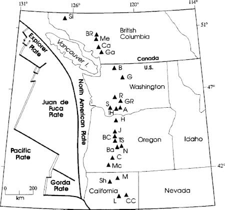
FIGURE 3.1 Map showing the Cascade Arc and modern plate configuration (modified from Mooney and Weaver, 1989). Volcanoes: Si, Silverthrone; Br, Bridge River cones; Me, Meagher Mountain; Ca, Mount Cayley; Ga, Mount Garibaldi; B, Mount Baker; G, Glacier Peak; R, Mount Rainier; GR, Goat Rocks; A, Mount Adams; IH, Indian Heaven; S, Mount St. Helens; H, Mount Hood; J, Mount Jefferson; BC, Belknap Crater; TS, Three Sisters Cluster; Ba, Mount Bachelor; N, Newberry Volcano; C, Crater Lake (Mount Mazama); Mc, Mount McLoughlin; M, Medicine Lake; Sh, Mount Shasta; L, Lassen Peak; CC, Cinder Cone.
The large volcanic centers of Mount Rainier, Mount Adams, Goat Rocks, and Mount St. Helens (Figure 3.2) form a triangular arrangement that is unique in the Cascades. These centers lie along the edges of a major midcrustal electrical conductivity and magnetic anomaly that may represent sedimentary rocks deposited in a marine forearc basin and thrust against a Cretaceous-age (approximately 65-million to 140-million-year-old) continental margin, according to Stanley and others (1987, 1992). This anomaly is labeled "SWCC" in Figure 3.2. Mount Rainier, Mount Adams, and Goat Rocks volcanoes are probably located along the Late Cretaceous continental margin that forms the east side of the SWCC; Mount St. Helens occurs on the western margin of the SWCC.
Major fault systems in the region (see Figure 3.2) show no evidence of current seismicity. Twenty years of monitoring by the Washington Regional Seismograph Network show that seismicity borders the southwest side of the SWCC along the St. Helens seismic zone (SHZ; Weaver and Smith, 1983), the northwest side of the SWCC along a north-south zone in the western Rainier seismic zone (WRSZ) about 15 km west of Mount Rainier, and the east side of the SWCC along a poorly defined zone of earthquakes near Goat Rocks Volcano (Figure 3.2). A cluster of earthquakes is also located directly under Mount Rainier; this cluster is so shallow that it is probably related to small stress changes in the magmaconduit system rather than to regional stress (Malone and others, 1991).
Earthquakes up to magnitude 4 are frequent in the WRSZ, and a 5.5-magnitude event occurred just south of this zone in 1987, near Storm King Mountain between Morton and Elbe, about 35 km from Mount Rainier. The length of the WRSZ (25 km) is such that an earthquake of magnitude 6 or larger is possible if a single fault plane extends that distance (Weaver and Smith, 1983); large stresses would be placed upon the edifice by ground shaking during such an earthquake, and this could lead to slope failure or large debris flows along major drainages, as discussed previously.
Geologic observations suggest considerable Neogene uplift of the Mount Rainier area. Structure contour maps suggest that the Columbia River Basalt Group (CRBG) was uplifted more than 1.5 km along the Cascades at the general latitude of Mount Rainier and Goat Rocks volca-
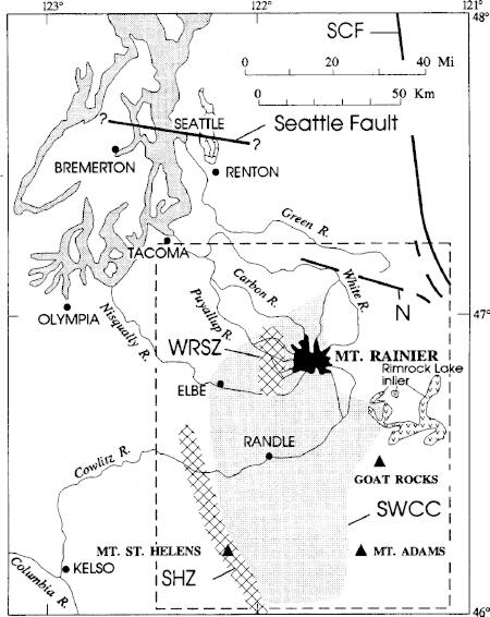
FIGURE 3.2 Map of Mount Rainier and surrounding areas showing the locations of major crustal features: WRSZ, western Rainier seismic zone; SHZ, St. Helens seismic zone; SWCC, southern Washington Cascades conductor; SCF, Straight Creek Fault (inactive); N, Naches fault zone (also inactive); the Seattle Fault was recently discovered and is thought to be active. The dashed box shows the approximate area for the recommended regional studies.
noes (Swanson and others, 1979; unpublished field data of D. A. Swanson). The amount of uplift decreases south of this latitude and probably northward as well, although the entire Cascade Range in Washington experienced some uplift. For example, Tolan and Beeson (1984) have suggested that the crest of the Cascades on the Oregon-Washington border may have been uplifted 500 to 600 m in the past 2 million years. Uplift of the Mount Rainier area took place in the past 15 million years, probably mostly in the past 12 million, based on the age of uplifted units of the CRBG. The presence of the coarse-grained mid-Miocene Tatoosh pluton directly beneath Mount Rainier suggests uplift and erosional unroofing of 1 km or more.
Uplift of the volcano may be due to magma injection in the middle and upper crust, although some uplift may be related to subduction processes that raised the Olympic Mountains beginning about 12 million years ago (Brandon and Calderwood, 1990). In order to interpret local evidence for uplift, it is essential to investigate other uplift and deformation components such as those related to retreat of Puget Sound glaciers and tectonic deformation of the arc region caused by subduction. Such investigations inherently involve a broader look at the southwestern Washington region.
Development of the Volcanic Edifice
The geology of Mount Rainier's edifice has received little study since the work of Fiske and others (1963). That research defined the geologic framework of Mount Rainier National Park, and to some extent the stratigraphy north and east of the park (Waters, 1961), but was not sufficiently detailed to reveal (1) the eruptive history of Mount Rainier proper; (2) structural features of the volcanic edifice, including small-scale faulting and dike swarms; and (3) the distribution of hydrothermally altered, structurally weakened rocks. These aspects of the geology are particularly important when evaluating volcanic hazards.
Development of the Mount Rainier Volcano probably began in the early or middle Pleistocene (i.e., 0.7 million to 1.7 million years ago;
Crandell, 1963; Crandell and Miller, 1974). Multiple lahars and layers of tephra from Mount Rainier are interbedded with glacial deposits in the adjacent Puget Lowland. Clasts in the lahars, as well as the tephra, contain hornblende phenocrysts and are unlike most products of the modern volcano. These volcanic rocks, assigned to the Lily Creek and Puyallup Formations, have reversed magnetic polarities and are older than an 840,000year-old layer of volcanic ash (Easterbrook and others, 1981, 1985). These rocks record the early eruptions of Mount Rainier or its ancestor.
The base of the modern volcano overlies a rugged surface eroded into Tertiary-age (1.7-million to 65-million-year-old) rocks of the Cascade volcanic arc. Most of Mount Rainier's cone was built by lava flows of intermediate composition interbedded with breccia and minor tephra, including pumice. High on the cone, the flows are rarely more than 15 m thick. Many flows thicken downslope and are more than 60 m thick on the lower slopes of the cone, where they partially fill paleovalleys (Fiske and others, 1963). The paleovalleys are eroded into the basement rocks radial to the volcano; an earlier cone may have conditioned the development of this radial drainage. Much of the breccia on the cone was probably produced by the interaction of lava flows with snow or glacier ice or from autobrecciation of the flows themselves, but some of the breccia was probably derived from explosions and lahars. Radial dikes, which may have fed some of the flows, are prominent in places (Smith, 1897; Coombs, 1936; Fiske and others, 1963). Little petrographic or chemical study has been made of Mount Rainier's rocks; what has been published (Coombs, 1936; Fiske and others, 1963; Condie and Swenson, 1973) indicates petrographically uniform two-pyroxene andesite and basaltic andesite. Dacite and basalt are present but apparently uncommon.
The flows and breccias eventually built a cone standing between 2,100 and 2,400 m above its surroundings before the end of the last major glaciation about 10,000 years ago. Two late Pleistocene vents erupted more mafic olivine-phyric basaltic andesite near the northwest base of the cone after Mount Rainier was almost fully developed (Fiske and others, 1963). Additional lava flows may have been added to the volcano in the late Pleistocene and early Holocene, but they have not been dated.
The largest known explosive eruption of Mount Rainier occurred between about 30,000 and 100,000 years ago and is recorded by a pumice deposit that has been recognized northeast, east, and southeast of the volcano. The deposit is about 2 m thick at a site 12 km northeast of the present summit (D. R. Crandell, written communication, cited in Hoblitt and others, 1987). Its distribution and thickness farther east are not known, nor is it known whether the thickness of 2 m is uniform along the axis of the deposit. This observed thickness at a distance of 12 km is greater than that of tephra layer Yn at a similar distance from Mount St. Helens (Mullineaux, 1986) but less than that of layers B and G from Glacier Peak (Porter, 1978). Layers Yn, B, and G all have estimated volumes equal to, or greater than, 1 km¬ (Crandell and Mullineaux, 1978; Porter, 1978). The limited thickness data for the tephra layer at Mount Rainier suggest that it may have a comparable volume. The volume of this late Pleistocene tephra is probably at least an order of magnitude greater than that of the most voluminous tephra layer of postglacial age.
The andesitic summit cone (Columbia Crest; Fiske and others, 1963, Figures 49 and 55; see also Figure 2.4 (A) of this report) is a late Holocene feature, built during the same period as the eruption of tephra layer C between 2,200 and 2,500 years ago. This cone may have developed in a crater produced by the edifice collapse that generated the Osceola Mudflow (Crandell, 1969; Mullineaux, 1974). This well-preserved cone stands about 250 m above the present crater rim. Two small craters indent the top of the cone; their rims are commonly free of snow as a result of fumarolic activity.
Holocene eruptive activity at Mount Rainier (Table 2.1) produced 11 tephra layers ranging in estimated volumes from 0.001 to 0.3 km3 (Crandell and Mullineaux, 1967; Crandell, 1969; Mullineaux, 1974). The most voluminous tephra, layer C, has blocks and bombs as large as 30 cm in diameter at a distance of 8 km from the summit of the volcano. This layer is about 15 cm thick at a distance of 12 km east of the summit, and 8 cm thick at a distance of 25 km from the summit. Mullineaux (1974) estimated its minimum uncompacted volume to be about 0.3 km3. A possibly correlative hot block-and-ash flow was emplaced west of the volcano in the South Puyallup Valley (Crandell, 1971). In addition to the Mount
Rainier tephra, ash from Mount Mazama (Crater Lake) and Mount St. Helens is widespread within the National Park (Mullineaux, 1974).
The eruptive products of Mount Rainier have been characterized petrographically as chemically homogeneous two-pyroxene andesite that commonly contains traces of olivine and very rarely hornblende (Fiske and others, 1963, 1964). However, few samples were examined and no new geochemical data were presented by Fiske and his colleagues. To date, only 15 chemical analyses, ranging from medium-K silicic andesite to lowsilica dacite, have been published; 5 of those analyses date from the 1930s (Coombs, 1936). In a more recent study of tephra deposits from Mount Rainier, Mullineaux (1974) showed that magmas encompassing a larger diversity in phenocryst populations, whole-rock compositions, and melt compositions, including probable basaltic liquids, have been erupted from the volcano. Thus, the true abundances of magma types erupted from Mount Rainier and their associated eruptive behavior are poorly known. Two-pyroxene andesite clearly predominates, but more primitive as well as more evolved lavas are present.
During the Holocene, more than 60 debris avalanches and lahars swept down valleys heading on the volcano; the largest, the Osceola Mudflow (Table 2.1), reached an arm of Puget Sound more than 100 km from the summit (Figure 2.5; Crandell, 1971; Scott and others, 1992). Some of the debris flows contain relatively abundant clay-sized material, which evidently was derived from hydrothermally altered rocks excavated by phreatic or phreatomagmatic explosions or by the gravitational collapse of a sector of the edifice weakened by hydrothermal alteration (Frank, in press). Deposits of several lahars suggest that large collapses (> 0.2 km3) of hydrothermally altered rock debris have occurred at least three times in the past 5,000 years. Recent work by Scott and others (1992) has verified the presence of clay-rich debris flows and describes the important rheologic distinctions between clay-rich (''cohesive") and clay-poor ("noncohesive") debris flows. Scott and others (1992) ascribe the clay-rich debris flows to edifice failure of hydrothermally altered rocks.
Mount Rainier has an active hydrothermal system that perpetuates snow-free areas near the summit (Figure 3.3) and leaks fluid laterally.
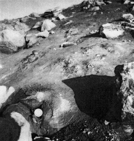
FIGURE 3.3 Snow- and ice-free area containing fumaroles and heated ground on the rim of West Crater near the summit of Mount Rainier. A thermometer, shown for scale, is in a fumarole. Hydrothermal activity in this area has formed clay-rich deposits across an area spanning 1 km. (Photo courtesy of David Frank, U.S. Environmental Protection Agency.)
Regional Studies to Assess Volcanic Hazards
The Mount Rainier region as defined for the purposes of this report extends from the Seattle-Tacoma metropolitan area on the north to the Columbia River on the south, and includes Mount Rainier, Mount St. Helens, and Mount Adams (Figure 3.2). A coordinated program of geologic and geophysical research within this region would address several important questions related to potential volcanic and associated hazards from Mount Rainier. Questions that need to be addressed include:
-
What are the tectonic processes that control locations of volcanoes in this region? In particular, what are the relationships between volcanoes, subduction, and major crustal accretionary boundaries?
-
What is the stress field in this region and how does it affect volcanism and seismicity near Mount Rainier? In particular, are there strike-slip zones that intersect the volcano, and, if so, what is their relationship to strike-slip activity along the SHZ and the WRSZ?
-
What is the deformation field in the region caused by magma injection, oblique subduction, and glacial unloading?
-
What are the ages, distributions, and characteristics (volumes, thicknesses, emplacement velocities) of lavas, tephras, and lahars from the volcano?
These questions can be addressed through a program of regional geologic mapping, petrologic and geochemical studies, geophysical studies, and drilling, as discussed in the following sections.
Geologic Mapping
At present, bedrock geologic information in the Mount Rainier region is inadequate to understand the history of the volcano. The reconnaissance geologic map of Mount Rainier National Park by Fiske and others (1963) has not been superseded by more detailed geologic mapping. Recent geologic map compilations of the southwest quadrant of the Washington State geologic map (Walsh and others, 1987; see Figure 2.2) provide an improved regional framework but lack detail. A strip of 7.5-minute quadrangles in an east-west zone south of Mount Rainier is currently being mapped by geologists from the USGS (for example, Evarts and others, 1987; Swanson and Evarts, 1992). This mapping complements the proposed USGS Deep Continental Studies Program referred to earlier in this chapter. In addition to this transect mapping, geologic mapping by faculty and students at Portland State University is proceeding east of Mount Rainier in the Fifes Peaks and Bumping River area (Brunstad and others, 1992; Hammond and Cole, 1992).
Detailed geologic mapping of Mount Rainier is necessary to reconstruct the history of the volcano, determine its structure and stability, and elucidate eruption and edifice failure processes. Features of particular interest include extrusive and intrusive rocks, faults, hydrothermal alteration zones, springs, fumaroles, glaciers, and surficial deposits. Geologic mapping of the volcano must be supported by isotopic dating to test geologic correlations and establish the chronology and rates of edifice growth and destruction. Paleomagnetic studies will also be required to evaluate geologic correlations, define eruptive sequences, and constrain emplacement temperatures of fragmental deposits.
Petrology and Geochemistry
Petrologic studies are needed to reconstruct the evolution of the magma system through time and to evaluate the physical characteristics of the magma and its transport from depth to the surface. These studies are important for identifying petrologic or petrochemical cycles that may culminate in explosive volcanism and for providing basic knowledge on the development of a large composite cone. The results from such studies would apply to other arc volcanoes, both in the Cascades and elsewhere. The petrologic knowledge of Mount Rainier clearly lags far behind that of neighboring volcanoes, such as Mount St. Helens (Smith and Leeman, 1987, 1993) and Mount Adams (Wes Hildreth, U.S. Geological Survey, unpublished data).
Sampling for petrologic studies must be coordinated with geologic mapping so that samples represent explicitly mapped geologic units. Petrochemical studies can be used to help establish the stratigraphic relations among flows making up the edifice. This type of systematic approach has recently been applied successfully to Mount Jefferson in the Oregon Cascades (Conrey, 1991). Samples selected on the basis of geologic context and the petrographic and compositional reconnaissance can be subjected to more detailed geochemical, isotopic, and phase-chemistry studies; techniques of experimental petrology can be applied to evaluate magma and magma-reservoir properties, including such parameters as reservoir depth and magma temperature, viscosity, and rise rate. Petrographic and wholerock geochemical reconnaissance (such as x-ray fluorescence for major and trace element analyses) need to be carried out on all such samples.
Chemical differences among eruptive units are typically very subtle, and experience shows that geochemical methods are most useful when two conditions are satisfied: (1) that many analyses for major and trace elements are available, and (2) that all analyses are performed under identical laboratory conditions. Several different investigators and laboratories will probably be involved in studies of Mount Rainier, so interlaboratory standards and comparisons must be developed and maintained to ensure maximum utility and reliability of analytical data.
Rather extensive geochemical data on Quaternary volcanic rocks in the region exist (for example, Clayton, 1983; Hammond and Korosec, 1983; Korosec, 1989; Leeman and others, 1990; Wes Hildreth, unpublished data for Mount Adams), including some trace-element data and isotopic data, chiefly Sr-isotope ratios. Quaternary basalt is of two types, tholeiitic and calc-alkalic, but basaltic andesite to high-SiO2 dacite are generally calc-alkalic. A few basalt flows are alkalic, some highly so.
The geochemistry of Tertiary volcanic rocks is less well characterized, but major-element data for mapped quadrangles (for example, Evarts and others, 1987; Swanson, 1992) indicate that Tertiary units are a mixed tholeiitic and calc-alkalic assemblage independent of SiO 2 content and range from basalt to rhyolite. Better regional knowledge of the Tertiary rocks is needed, because of the insights that magma compositions, geobarometry, and mineral chemistry can provide to address crustal composition, thickness, magma storage, and magma genesis. For example, major-element analyses in areas currently being mapped suggest that the crust thickened substantially during growth of the Cascade arc (Swanson, 1992). This hypothesis needs to be tested. The improved coverage must be tightly controlled stratigraphically and must include trace element and isotopic information.
Few isotopic and fission-track ages are available for pre-Holocene rocks and unconsolidated deposits throughout the entire study area (Mattinson, 1977; Hammond and Korosec, 1983; Evarts and others, 1987; Vance and others, 1987; Korosec, 1989). The overall scarcity of ages reflects both the difficulty in obtaining reliable ages for the altered Tertiary rocks and the lack of concerted effort to do so. Radiometric ages are essential for understanding recurrence intervals of volcanic eruptions at Mount Rainier and in the surrounding region. For Tertiary rocks, paleomagnetic techniques may be useful for placing constraints on ages. Improved age control for rocks in the region is an important goal of this Decade Volcano Demonstration Project.
Geophysics
Geophysical studies, such as seismic surveying, gravity and aeromagnetic mapping, electrical surveying, and ice-penetrating radar surveying, will provide data to define the following elements of the volcano:
-
distributions of hydrothermally altered rock, intrusive bodies, and faults;
-
presence and distribution of magmas;
-
distribution of hydrothermal and groundwater systems; and
-
distribution of glacier ice and the configuration of the subglacier surface.
In addition, measurements of precipitation and stream and spring discharges combined with chemical and isotopic studies will provide important constraints on the hydrologic budget and storage and transport of water within the volcano.
Seismic studies are essential to assess potential earthquake-generated hazards, including eruptions, edifice failure, and glacier outburst floods. The influence of seismic activity on edifice stability must be evaluated carefully because of the sporadic occurrence of large crustal earthquakes in southern Puget Sound, such as the 7. 1-magnitude (1949) event that occurred at a depth of 25 km and the 6.5-magnitude (1965) event that occurred at a depth of 60 km. Recently discovered evidence of widespread, abrupt coastal subsidence in Washington and Oregon, and comparison of the present Cascadia subduction zone with other Pacific rim zones, together suggest that large subduction-zone earthquakes must be considered in hazard assessments for the Mount Rainier region (Atwater, 1987; Heaton and Hartzell, 1987). Atwater (1987) and Heaton and Hartzell (1987) suggest that the magnitude of such an earthquake could exceed 8.5, compared to the 7.1 subduction-zone event that occurred in 1949 as noted above, which is the maximum recorded earthquake in the region.
Regional seismic studies, as well as seismic observations on the edifice itself, utilize the University of Washington's regional seismic network, which was expanded considerably after the Mount St. Helens eruption. This expanded network has allowed detailed investigations of the WRSZ and other features that relate seismicity and tectonics in the region. In addition, data from the network have been used to show that many of the seismic events occurring on the edifice are due to glacier movement, outburst floods, and rain-triggered debris flows. To date, no low-frequency earthquakes characteristic of magmatic activity have been recorded at Mount Rainier. The network has also been used to perform tomographic imaging using teleseisms; these images show a crustal low-velocity zone that is spatially coincident with features mapped from magnetotelluric surveys. The tomographic studies also show a poorly resolved, low-velocity zone beneath Mount Rainier at depths of 9 to 25 km that may represent a magma body.
Additional tomographic studies of this kind are needed but will require increased seismometer density on the volcano to improve resolution of low-velocity "magma" zones. Demonstration of the usefulness of tomographic studies was provided at Mount St. Helens, where a high degree of detail in the subsurface was obtained with tomographic imaging using local earthquakes recorded on the local seismic network (Lees, 1992). Additions to the network are also needed to further investigate the WRSZ. This network must be expanded to cover an area extending 40 to 50 km from the volcano so that a 20-km target width can be analyzed.
An accurate seismic velocity model of the volcano and of the crustal rocks below is essential to locate seismic events of all types accurately. The existing velocity model is based on studies remote from the edifice and upon inferences about the velocities and structure of the volcanic rocks of the edifice itself. Additional data from both active and passive experiments on and around the volcano are needed.
Regional neotectonic and geodetic studies in the area shown in Figure 3.2 are largely nonexistent. Local horizontal-control networks exist at Mount St. Helens, along the SHZ north of Mount St. Helens, and at Mount Rainier. Expansion of regional surveys in western Washington
using GPS (Global Positioning System) is planned by USGS workers in 1994. This expansion will extend the GPS stations into southwestern Washington, including the Mount St. Helens region. This network needs to be expanded to the north and east to encompass the regional framework of Mount Rainier as well as the volcano itself.
Regional deformation and uplift due to magmatic intrusion or tectonics needs to be addressed, possibly with the aid of regional geomorphic studies and GPS measurements. Geodetic baselines need to be established across suspected strike-slip fault zones and over possible neotectonic features such as the northwest-trending anticline located just west of Mount Rainier. Geologic mapping of brittle-fracture indicators in surficial volcanic rocks and stress studies in boreholes must be a part of neotectonic research in the region, especially west and southwest of Mount Rainier in the area of current seismicity.
Heat flow in the region has been mapped in moderate detail (Blackwell and others, 1990). A heat-flow high occurs along the western flank of the Quaternary Cascades in Oregon and extends into the southeastern quadrant of the region outlined in Figure 3.2. A heat-flow profile has been completed along an east-west corridor south of Mount Rainier, but more measurements are required north of the Cowlitz River in the study area of Figure 3.2. Temperature and heat-flow measurements within the National Park would be useful for studying hydrothermal activity on and around the edifice.
Regional seismic-velocity information includes data from a north-south refraction/wide-angle reflection profile between Randle, Washington and the Canadian border (Luetgert and others, 1992). The crustal thickness determined from this survey is approximately 44 km (Walter Mooney, USGS, oral communication, 1992) and is approximately constant beneath the Cascades (Mooney and Weaver, 1989). Extensive deep reflection surveys, sponsored by the U.S. Department of Energy, using vibrating sources have been completed on five profiles within the region; however, these data do not allow mapping of the crust below about 8 km because of poor data quality at longer recording times (>3-4 s). In addition to the deep seismic profiling planned as part of the USGS Deep Continental
Studies Program, similar refraction/wide-angle surveys may be required across the WRSZ and along profiles north of Mount Rainier. The large shots required for any of the future deep seismic surveys must be deployed so that they can be used both for calibration of the network and tomography of the volcano, utilizing the expanded seismic network and portable instruments deployed at the time of the surveys. High-resolution seismic methods are needed to study shallow fault zones and neotectonic features.
Gravity, magnetic, and magnetotelluric (MT) or deep electrical sounding surveys have been valuable for studying the regional setting, but more work is needed around the volcano to place them in a regional context. For instance, the strong, northwest-trending gravity gradient near the center of the volcano (Finn and others, 1991) may be an expression of the interpreted major crustal boundary mapped with MT surveys. However, gravity control is poor within the National Park. More detailed coverage is needed on the Mount Rainier edifice, as well as in surrounding regions, particularly in the WRSZ. Aeromagnetic data are adequate for both Mount Rainier and its surroundings. Gravity and magnetic data have been used at other Cascade volcanoes to locate buried intrusive bodies. Examples include Goat Rocks Volcano (Williams and Finn, 1987) and Mount St. Helens (Finn and Williams, 1987; Williams and others, 1987).
MT survey coverage is relatively good on a broad regional scale (Stanley and others, 1992), but more data are needed in the region southeast of Mount St. Helens, north of Mount Adams, in the area of the WRSZ, and within the National Park. A recently acquired detailed MT profile across the WRSZ that extends into the western part of the National Park indicates that the regional deep crustal conductor (SWCC) is highly constricted to the width of the Carbon River anticline that encompasses the WRSZ (W. D. Stanley, USGS, oral communication, 1993). Additionally, an earthquake swarm in July and August 1988 appears to be related spatially to an intrusive body (probably Miocene in age) within the Eocene marine shale that has been interpreted to constitute most of the regional electrical conductor (Stanley and others, 1992). The conductor was traced to within 10 km of Mount Rainier at the east end of the MT profile.
Detailed MT and other electromagnetic surveys within the National Park would help locate alteration zones (electromagnetic methods are very sensitive to hydrothermal alteration) that represent potential sites of edifice failure, as well as zones of faulting and other hydrothermal systems on a regional scale. Several northwest-trending alteration zones occur north of the National Park. Electromagnetic surveys could help resolve whether these zones are expressions of strike-slip faults that extend southward beneath the volcano.
Arrays of portable, three-component magnetometers can be used for electromagnetic imaging of the deep electrical structure of the volcano, including magma bodies. This technique, known as geomagnetic depth sounding, or magnetovariation sounding, has the advantage of not requiring measurements of the electrical field. Such measurements would be difficult on many parts of the volcano because of the long wires needed for connecting electrodes to a data logger. Magnetometer-array studies were the first to locate the SWCC (Law and others, 1980) and could be used effectively in a combined regional and detailed study of Mount Rainier and its tectonic setting. A broad variety of electromagnetic methods, coupled with geodetic and neotectonic research, provides a good regional method of locating such faults.
Remote-sensing techniques, including multiband spectral imaging from satellite and aircraft platforms, can be used to study the edifice and surrounding region. Infrared imaging of the volcano has been used to map thermal areas at the summit, along fractures, and at other rock outcrops, as first shown by Moxham and others (1965). Multiband, near-infrared, and other remote-sensing data would be useful for mapping alteration patterns on the edifice, some of which might be related to strike-slip faulting and other neotectonic features in the region. In particular, multichannel spectral data obtainable with new aircraft-based instrumentation have the potential for discriminating alteration minerals in great detail. Such data could provide even more specific mineralogic information on surficial rocks and zones of alteration. Side-looking radar (SLAR) data may be useful for locating and mapping lineaments and faults.
Drilling
The evaluation of data and testing of models developed from the regional investigations discussed previously may require drilling. For neotectonic and fault studies, drillholes would be relatively shallow and could be used for multiple purposes, such as heat-flow measurements, borehole-seismometer installation and in situ stress measurements. A plan for deep drilling (5 to 10 km) in the western part of the SWCC and on the SHZ was presented several years ago to DOSECC (Deep Observation and Sampling of the Earth's Continental Crust, a government-funded university consortium for scientific drilling), but the project was not approved. A carefully designed science plan to drill a specific target could greatly advance understanding of the magmatic and tectonic processes at Mount Rainier and would be a logical follow on to the studies outlined in this report.
Hazard Studies
In addition to the general studies outlined above to elucidate development of the edifice, special attention needs to be focused on understanding lahars and edifice collapse, two hazards of particular significance for residents in surrounding areas.
Lahars
Lahars probably constitute the greatest hazard to life and property in the Mount Rainier region, and consequently they are an important focus of research. Recent work led to the discovery of several previously unknown lahar deposits (Scott and others, 1992). This work has demonstrated the need for detailed mapping of lahar deposits to establish a complete
history of events. Correlations using cuttings from boreholes in adjacent lowland areas would help identify the downstream extent of lahars and lahar runouts. Such information would also improve volumetric estimates of alluviation during single lahar events and eruptive episodes and would allow better evaluation of liquefaction susceptibility of such deposits (Palmer and others, 1991; Pringle and Palmer, 1992).
Wood, which is commonly preserved in lahar deposits, can be used for dating and correlation studies through high-precision radiocarbon analyses and dendrochronology. For events of the past few centuries, it may be possible to achieve calendar-year accuracy using dendrochronologic methods, as Yamaguchi (1983, 1985) demonstrated at Mount St. Helens. A chronology developed using a combination of these techniques would be useful in discriminating separate events in the geologic record and in correlating among different types of deposits, such as pyroclastic flows and lahars produced during the same eruptive episode. An improved chronology might also allow mass movements on the volcano to be correlated with paleoseismic events in the Pacific Northwest (for example, Atwater, 1987; Bucknam and others, 1992; Karlin and Abella, 1992).
Edifice Collapse
Most of the geologically or hydrologically hazardous events-eruptions, collapses, and slope failures-have originated, and are likely to originate in the future, from the upper parts of the edifice. The large volume of ice and snow can amplify the destructive potential of these events. The evaluation of hazards that originate from Mount Rainier requires a comprehensive investigation of the edifice, including the following topics:
-
history of growth and failure of the edifice;
-
present structure and stability of the edifice and ice cap;
-
the evolution and present state of the magma-supply system;
-
the distribution and transport of water in the edifice; and
-
the roles of water, ice, and hydrothermal alteration in past eruptions and gravitational failures.
Some portions of the volcanic edifice are more likely than others to fail by gravitational sliding or collapse along preexisting structural weaknesses such as faults or dike swarms. Dikes have been mapped on Puyallup Cleaver, along the arête on the east edge of Winthrop Glacier, and on Little Tahoma Peak. Fiske and others (1963) note that dikes are more abundant than is indicated on their geologic map. The distribution and orientation of faults and dikes, important for assessing the structural integrity of different parts of the volcanic edifice (Fink, 1991), can be determined only by more detailed geologic mapping.
A distinctive characteristic of the huge Osceola Mudflow that is indicative of its origin is its relatively high content of clay-size material, thought to be mostly clay minerals. Mullineaux (1974) found that an ashfall deposit contemporaneous with the Osceola Mudflow, the F tephra, contains both fresh, newly erupted magma and abundant clay minerals. This finding suggests that much of the clay in the Osceola Mudflow originated from hydrothermally altered rocks derived from the edifice by gravitational collapse or volcanic explosions during an eruption of juvenile magma (such as the eruption of Mount St. Helens in May 1980; for example, Janda and others, 1981; Voight and others, 1981). Such altered rocks are weaker than fresh lava flows and are thus more prone to failure. The distribution of hydrothermally altered rocks on Mount Rainier is clearly significant for assessing the structural integrity of the edifice and can only be determined by detailed geologic mapping and sampling. As previously noted, remote sensing can aid the mapping of alteration zones. The physical properties of hydrothermally altered rocks can be assessed through quantitative mineralogical and mechanical analyses.
Hot springs and fumaroles are surface manifestations of the hydrothermal system within the edifice, which is the primary agent of rock alteration and a major influence on slope stability. The process and extent of wallrock alteration by hot gas and water require better delineation,
particularly in the context of the extensive glacier mantle on the volcano. Glaciers may hide significant areas of alteration, and their presence may greatly enhance rock alteration by trapping hot gas and allowing the substrate to ''stew in its own juice" (Carrasco-Núñez and others, 1993). Understanding the fundamentals and areal extent of this alteration process constitutes one of the most important tasks of Decade Volcano research at Mount Rainier.
Recommendations
Coordinated research of Mount Rainier and the surrounding region, shown in Figure 3.2, should be undertaken as part of this Decade Volcano Demonstration Project. Regional studies are needed to address the formation and subsequent development of Mount Rainier within the Cascade volcanic arc environment. Of particular importance in this context are studies of the following:
-
tectonic processes that control the locations of volcanic vents;
-
regional stress fields and their effects on volcanism, faulting, and seismicity;
-
the crustal deformation field caused by magma injection, subduction, and glacial loading; and
-
ages, distributions, and characteristics of tephras, lavas, and lahars.
Studies of Mount Rainier itself are also needed to address the development of the edifice in order to predict its future behavior. Of particular importance are studies that address these topics:
-
the structure of the volcanic edifice and underlying crust, including
-
distributions of magmas, intrusive and extrusive rocks, faults, dikes, and glacial ice;
-
the history of edifice growth and failure;
-
the geometry of hydrothermal and groundwater systems; and
-
distributions of hydrothermally altered rocks.
A high degree of feedback between local and regional studies and between individual projects such as geologic mapping and geophysical surveys should be employed as part of the strategy for this Decade Volcano Demonstration Project. This project should be coordinated with ongoing research programs of federal, state, and academic scientists and should include the following elements:
-
Geologic mapping. Mapping the spatial and temporal distributions of eruptive and intrusive rocks, faults, hydrothermal alteration zones, surficial deposits, springs, fumaroles, and glaciers should be undertaken as part of the effort to understand the development of the Cascade volcanic arc and Mount Rainier edifice. This mapping work should be supported by dating and paleomagnetic studies to establish correlations, chronologies, and rates of edifice growth and failure. Geologic mapping is particularly needed in and adjacent to the WRSZ and Mount Rainier National Park.
-
Petrologic and geochemical studies. Petrologic and geochemical (including isotopic) studies of Tertiary and Quaternary (particularly Holocene) rocks should be undertaken to address the physical characteristics and evolution of the magma systems through time, to help establish stratigraphic relations among eruptive products, and to provide the basis for reconstructing patterns of hydrothermal alteration. The isotopic work should include radiometric dating to establish recurrence intervals for volcanic eruptions at Mount Rainier and adjacent volcanoes. This petrologic and geochemical work should be coordinated with mapping efforts so that samples can be tied to explicitly mapped geologic units. In support of this effort, interlaboratory standards should be developed and maintained to establish the high level of analytical control needed to detect the subtle chemical variations expected between eruptive units.
-
Geophysical surveys. Geophysical surveys should be undertaken to elucidate the structure of the volcanic edifice and underlying crust, including distributions of magmas, intrusive bodies, faults, hydrothermal and groundwater systems, and glacier ice. Several types of surveys should be carried out to support this effort:
-
Earthquake surveys, utilizing the regional seismic network to investigate patterns of seismicity and to obtain tomographic images of the crust beneath the edifice. Selective additions to the regional seismic network should be made to improve earthquake detection in poorly covered areas east and south of Mount Rainier and to improve the spatial resolution of deep-seated velocity contrasts for tomographic studies. A tomographic investigation of the type recently completed at Mount St. Helens (Lees, 1992) should be undertaken for Mount Rainier.
-
Seismic surveys, particularly refraction/wide-angle reflection surveys across the WRSZ and in the region north of Mount Rainier, to elucidate crustal structure; high-resolution seismic surveys, to study shallow fault zones and neotectonic features.
-
Geodetic surveys, utilizing GPS to monitor deformation of the region. As part of this effort, the existing geodetic network should be expanded to cover the entire region outlined in Figure 3.2 and should include an array of stations on the edifice.
-
Heat-flow surveys in the Cowlitz River area (Figure 3.2) and on Mount Rainier itself to identify areas of present-day hydrothermal activity.
-
Potential field surveys surveys, including gravity and MT surveys to locate magma and other intrusive bodies, faults, and hydrothermally altered rocks. As part of this work, the existing gravity, magnetic, and MT surveys should be reprocessed to better define the SWCC and its relation to mapped geology.
-
Remote-sensing surveys, including multiband spectral imaging to map patterns of hydrothermal alteration on the edifice, and SLAR to locate and map small-scale lineaments and faults.
-
Lahar Studies. Special attention should be given to the investigation of lahars, probably the most significant volcanic hazard to life and property in the Puget Lowland area. Detailed mapping, including subsurface mapping, should be carried out to reconstruct the spatial and temporal distributions of these flows and to obtain volumetric estimates for each flow event. This work should be supported by high-precision radiocarbon and dendrochronology analyses to establish flow correlations and chronologies.
-
Edifice stability assessment Edifice collapse is also a significant hazard to life and property in the Puget Lowland area; it warrants careful study. Research on edifice stability should focus on mapping the distributions of hydrothermally altered rocks, faults, and dikes, which are mechanically weak and prone to failure. The physical properties of hydrothermally altered rocks should be assessed through quantitative mineralogical and mechanical analyses. Research should also focus on the delineation of the hydrothermal system and the process of wallrock alteration, particularly beneath the glaciers that cover the edifice.


