
6
NAUTICAL INFORMATION PRODUCTSAND THEIR DISSEMINATION: TOWARDA NEW WAYOF DOING BUSINESS
Historically, the mission of the Nautical Charting Division of the National Oceanic and Atmospheric Administration's (NOAA's) National Ocean Service has been to provide nautical information to mariners by publishing charts and related information products, such as Coast Pilots (detailed navigation guides to specific areas) and tide tables. NOAA has supported this mission primarily with in-house survey and chart production activities. As described in earlier chapters, changes in technology and user demands now increasingly call for adjustments in the way NOAA defines and approaches its mission. This chapter deals with changes that NOAA could make in its relationships with the private-sector companies that produce value-added nautical information products that would improve the agency's ability to meet changing user needs for new and varied products.
Some aspects of the present system for supplying products to users are not sufficient, as demonstrated in Chapter 2. Additionally, in the future, as demand grows for more custom paper products and for a variety of digital information products (see Chapter 5), it is not likely that NOAA can adapt quickly to meet those needs, given its resource constraints and the inherent limitations of a large agency. This chapter suggests new approaches for generating and distributing new products rapidly and efficiently while meeting legal requirements and maintaining necessary standards of accuracy and quality.
The alternatives addressed in this chapter for enhancing nautical information products and services are rooted in closer alliances between NOAA and the private sector. NOAA can take advantage of the capabilities and flexibility of private commercial partners to quickly evolve and manufacture diverse nautical information products, achieve rapid and efficient distribution of these products, and possibly generate additional revenues for itself (see Chapter 7). NOAA can focus its own efforts on the maintenance, quality control, and certification of the national hydrographic data base, in support of public and private ventures to provide and disseminate products.
THE PRESENT SYSTEM OF PRODUCTION AND DISSEMINATION
The nautical chart and information product mix consists of selected presentations of nautical data sets (today, mostly paper charts), each of which is characterized by its coverage, scale, and content; accuracy; medium and format (paper, digital); and update/reissue frequency. The need for these products defines and drives the nautical
charting mission. Individual products are derived from the collection of nautical chart information by NOAA, which includes all analog (paper) and digital data records collected or archived by NOAA. In addition to NOAA's nautical chart products, private vendors produce charts, digital products, and publications to meet some aspects of user demand. Most of these products are derived from NOAA products.
NOAA Products
At present, NOAA's nautical chart and information products are paper charts, supporting publications such as Coast Pilots and tide tables, and periodic updates disseminated on paper and via radio transmissions as Notices to Mariners. Nominal print cycles for NOAA's charts range from 6 months to 12 years. In practice, new editions are triggered by the accumulation of critical corrections, significant format or regulation changes, new basic data, low shelf stock, and available resources. Critical corrections include changes to aids to navigation, obstructions and shoaling, and cultural and facility changes. Typically, 30 to 70 critical changes trigger a new edition. In fiscal year 1991, NOAA produced 351 new editions of conventional charts, or 415 new editions including small-craft and other charts.
In addition to charts, NOAA publishes a series of Coast Pilots: four volumes for the East Coast of the United States, one for the Gulf of Mexico and parts of the Caribbean, one for the Great Lakes, one for the West Coast, and two for Alaska. All are revised annually expect those for Alaska, which are revised biennially.
Commercial Products
At present, about a dozen U.S. companies are copying NOAA charts (and those published by the Defense Mapping Agency and other hydrographic agencies) for resale as value-added products. They reproduce the charts in a variety of formats, including waterproof paper, smaller paper size, and chart books containing several charts for a region. Exact numbers are not available, but sales of these products are substantial and certainly exceed NOAA's sales volume. Because they are not bound by any contractual agreements with NOAA (and NOAA, like most U.S. government agencies, cannot copyright its products), private resellers have often priced their value-added reproductions below NOAA's chart price. These practices and pricing policies have contributed to the substantive erosion of NOAA's chart sales volume over the past decade. The privately reproduced charts are sold directly, by mail order, and through chart agents.
In a similar vein, several companies in the United States and abroad are engaged in digitally reproducing NOAA and other charts, either as raster images or as vector data products. Most are sold for use with electronic chart systems on recreational and fishing vessels, though some are also being used on commercial ships. These firms supply a market that NOAA does not serve at present in any way. Exact figures are not available, but annual sales of digital hydrographic data sets are estimated to be in the tens of thousands of units
(electronically programmable read-only memory (EPROM) cartridges, laser compact disks, or magnetic diskettes).
Because of liability concerns, private resellers of both paper and digital versions of NOAA charts often include disclaimers (usually something like ''not for use in navigation'') on their products. This disclaimer limits the use of such charts for fulfillment of international carriage requirements for commercial shippers but generally does not dissuade boaters from using them as a sole source of navigation information.
Distribution of Products
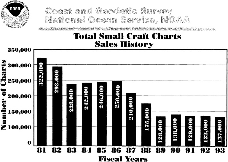
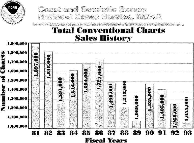
NOAA has over 2,200 nautical chart sales agents worldwide, varying in size from small marina operators to large map stores and ship chandlers. Those that sell to recreational users generally stock non-NOAA chart products as well. In fiscal year 1991, NOAA distributed about 1.4 million charts: 900,000 to government agencies (including the Navy), 400,000 to recreational boaters, and 100,000 to commercial navigators. While government consumption of NOAA charts has been fairly steady (with some temporary declines), public sales are down 50 percent since the early 1980s (Figures 6-1 and 6-2). Likely causes of this decline are the increase (due largely to the cost recovery requirement) in the retail NOAA chart price from $4 in 1981 to over $13 in 1991, combined with growing competition from the value-added reseller market. Other factors appear to be the decrease in number of U.S. flag ships and decrease in new editions due to declining funding for these activities.
SHORTCOMINGS OF THE PRESENT SYSTEM
Three major shortfalls of the present system are highlighted below.
-
There is a large demand for "custom" and value-added nautical chart and information products, both paper and digital, that is not (and cannot reasonably be) met by NOAA. Private resellers are responding to this demand, but they now do so without NOAA's active cooperation. The consequence is that "not for use in navigation" and similar legal fictions are featured prominently on commonly used products that few, if any, users buy for any purpose other than navigation. A better basis is needed for private-sector generation and distribution of value-added nautical chart products.
-
The frequency of updates/revisions of charts lags significantly behind the Notices to Mariners. The current process of incorporating changes into new NOAA chart editions involves many manual operations that propagate an update through all the affected products, and the printing process often takes months as well. As a consequence, NOAA's paper product updates often are scheduled at long intervals, and, more importantly, "new" charts are months out of date (i.e., behind changes announced in Notices to Mariners) by the time
-
users are able to obtain them from their chart agents. The production and distribution system needs to be improved to provide for faster generation and dissemination of new editions, updates, and value-added products.
-
The growing demand for digital nautical chart data products that meet legal carriage requirements cannot be met in the near future at the present rate of digitization of nautical information. This demand is likely to increase as electronic chart technology becomes standard equipment on commercial vessels. As with value-added paper chart products, the digital products offered at present by commercial ventures are inconsistent; offer limited coverage; and, without NOAA's cooperation and assistance, will not be certified for use in an official electronic chart display and information system. A better means must be found to satisfy the important and multifaceted demand for digital nautical chart data in a timely and effective way and to improve the accuracy and consistency of the digital products that NOAA now provides.
A STRATEGY FOR IMPROVEMENT
One approach to the question of appropriate public- and private-sector roles in supplying nautical information products is to assume that in the interest of efficiency, products and services ought to be delivered by private-sector operations governed by market forces unless there are sound reasons why the public sector must provide them. This is official U.S. government policy as articulated in Office of Management and Budget Circular A-76 (OMB, 1983). Maintenance of the national hydrographic data base is arguably a legitimate public-sector function. Data collection and (to a lesser extent) product dissemination also are treated as public-sector functions: NOAA now conducts surveys and prints charts. It is likely that, in the future, both functions could be served more efficiently with greater participation by the private sector.
To better and more efficiently satisfy user demands, NOAA could enter into partnerships with private companies for the printing, publishing, and distribution of nautical chart products. The advantages of this approach are extensive: NOAA can focus on its main areas of competence and responsibility of designing, building, and maintaining a data base of nautical information, and the public benefits from the wider and more rapid distribution of diverse (but quality-controlled) nautical chart products that are up to date and customized to the specific needs of user communities, such as commercial fishing and recreational boating. The rapid construction of a master digital nautical data base will ensure that NOAA's subsequent updating efforts add value to its core asset.
SUGGESTIONS FOR IMPLEMENTING THE STRATEGY
Institutional Arrangements
A variety of arrangements are possible to enlist the help of private-sector firms in the publication and distribution of nautical charts and information products. Possibilities include cooperative research and development agreements (CRADAs, as defined in the Technology Transfer Act of 1986), cooperative agreements (33 CFR 883e), contracting for the provision of services (33 CFR 883f), and licensing of data to the private sector. At the present time, NOAA lacks the legal authority to license its data. Legislation would have to be enacted to change this situation. There are also opportunities for NOAA to form data collection, printing, and data distribution partnerships with other federal agencies, and with states (see Chapter 5).
Partnerships allow NOAA to leverage others' capabilities for efficient customization, responsiveness to users, and technological efficiency. In effect, this is happening already, although on a limited scale and without NOAA's active participation. All parties will be better served with organized arrangements: user demands will be met more fully; private firms can use NOAA's participation in their efforts as a marketing tool; and NOAA can better accomplish its mission, obtain additional data, and (possibly) obtain a new source of funding (see Chapter 7).
Some federal agencies have already established successful records in using new mechanisms such as CRADAs for public/private partnerships (GAO, 1993). The Clinton administration has indicated strong commitment to support and promote better ways for the federal government to do business, including the specific partnerships described here. For this partnership approach to work at NOAA, relevant objectives will have to be incorporated into NOAA's strategic plan. Further, it is likely that some incentives would have to be provided initially to stimulate private-sector participation in what might be perceived as a risky venture. Considerations of the national interest in ensuring complete coverage of all U.S. waters—not merely those in which there is a strong interest by users—would also have to be built in to any agreements with private companies. In some cases, NOAA presently lacks the legal authority to engage in such arrangements and would have to seek legislation to permit them to take place.
Product Lines
NOAA could create partnerships of two different types--one for commercial vessel and one for small-craft charts—in order to meet the dramatically different needs of two practically and legally distinct groups of nautical chart users. Commercial vessels are defined as those of more than 1,600 tons displacement, which are now required to carry an updated NOAA chart, or International Hydrographic Organization-approved foreign equivalent, in U.S. waters. Small craft are not legally required at present to carry a chart. Both classes of users would benefit from products focused on their specific needs.
Small-Craft Chart Products
Currently, the needs of small craft are largely met by chart reprinters whose charts, in many cases, carry the generally disregarded warning "not for use in navigation." NOAA could seek partnerships with private chart reprinters and possibly collect a user fee in exchange for allowing the privately published small craft charts to carry a special version of the NOAA emblem or with a statement to the effect that the chart was created from certified NOAA data subject to update by Notice to Mariners and is intended for use in small-craft navigation.
Further, the private partner could be asked to assert its own copyright in the small-craft charts as derivative works under copyright law. These private copyrights, coupled with user preference for charts carrying the NOAA emblem, would provide significant competitive pressure on other chart publishers to also join in partnership with NOAA and pay user fees.
Following are suggested attributes of the small-craft chart process:
-
Small-craft charts should be packaged in an educational folder that describes their use.
-
Small-craft charts should carry the NOAA emblem with a designation that identifies the product as intended for use for nonregulated navigation.
-
NOAA should explore charging private publishers of small-craft charts a modest user fee.
-
NOAA's liability for small-craft charts should only extend to the accuracy of the base data or imagery supplied by NOAA. Liability for the product remains with the publisher, as it does now, but the sanctioned use of certified base data provides some protection and improves safety.
-
In cooperation with the U.S. Coast Guard, NOAA should explore the promulgation of a NOAA small-craft chart carriage requirement for vessels of a certain size and displacement.
A major benefit of these small-craft chart partnerships is the innovation in product design that will likely result and the improvement in safety that is likely to come from greater and more diverse distribution of chart products.
Commercial Vessel Chart Products
A parallel set of public and private cooperative agreements could meet the needs of the regulated commercial users of nautical charts, but there are several differences that have to be accommodated. The private publisher of commercial charts would include a NOAA emblem with the statement to the effect that "this chart is approved for use in regulated navigation requiting a NOAA or International Hydrographic Organization approved chart." Private publishers would be required to print and distribute NOAA's entire suite of charts and to subject their process to periodic independent inspection to ensure that they meet rigid
NOAA specifications regarding printing quality, paper, ink, and style. Given the fact that these charts are essentially printed under contract to and under the control of NOAA, NOAA would be liable for their accuracy, as is now the case.
Following are suggested attributes of the commercial charts process:
-
Commercial charts will carry not only the NOAA emblem but also a designation indicating that "this chart is approved for use in regulated navigation and meets SOLAS (Safety of Life at Sea) requirements."
-
Private partners who print regulated charts should be required to print the full suite of all NOAA charts and to meet rigid NOAA specifications regarding printing quality, paper, ink, style, etc. NOAA should periodically inspect and certify the process that each of its private regulated chart publishers uses.
-
Private partners who print regulated charts should be required to agree to a reasonable pricing structure in keeping with a reasonable margin of profit.
-
For regulated charts, NOAA should charge a meaningful user fee to its private partners.
-
Consistent with the need for NOAA to certify both the base data and the process used by the private publisher/partner, NOAA should completely indemnify the publisher and take all liability for the resulting product, much as it does now for nautical charts and as is extended to the private sector in the case of Jeppesen aeronautical charts. Legislation would be required to enable an arrangement for nautical chart products similar to the arrangement that applies to these aeronautical charts.
Digital Nautical Chart and Information Products
The legal requirements for paper charts may be modified in the future to allow use of a certified electronic chart system and data base in place of the paper chart. The Defense Mapping Agency already obtains digital nautical charts for U.S. waters from NOAA, and the Navy's requirement for paper charts may largely disappear by the end of the century. Increased use of electronic chart systems in the commercial sector, and the prospect of eventual carriage requirements for such equipment, will strengthen the requirement for NOAA to provide official digital data sets.
Partnership arrangements for producing and distributing electronic or digital chart products could be handled in much the same way as those for paper products, for both the small-craft and the commercial user segments. One significant exception is that for digital charts it is insufficient to ask the private partner to protect the products with copyright. The digital products need additional protection with licenses that restrict use of the data to the intended application. In most cases this would be a single user license per copy, but with appropriate legislation, NOAA's partnership agreements could additionally provide for digital licenses to allow the custom printing of charts to order, with a user fee paid for each chart, or for electronic on-line access to chart data, with a user fee paid on a per-transaction basis.
It will be instructive to observe the progress of foreign hydrographic offices, which in some cases are already putting in place public/private partnerships for production and
dissemination of digital nautical chart products. The Canadian Hydrographic Service is arranging a collaborative agreement for production and marketing of digital nautical charts, and the United Kingdom's Hydrographic Office is working with several commercial firms to develop standards for digital chart products.
Navy Products
Presently a major user of paper nautical charts, the U.S. Navy is moving toward digital navigation and a "paperless bridge." The Navy and the Defense Mapping Agency can obtain digital base data for U.S. waters from NOAA, as they are now beginning to do, and format these to their own requirements. Paper product needs that may arise during the transition to digital navigation can be met by private chart production partners.
Products for Other Users
As illustrated in Chapter 5, nontraditional users of nautical chart information are primarily interested in digital data. NOAA's private partner companies could serve as flexible customizers and distributors of hydrographic information for many other purposes in addition to navigation.
Legal Issues
Liability for accuracy and completeness of chart data and for its presentation is a serious concern in the preparation and distribution of nautical charts, both for traditional paper charts and for digital data sets. Following is a brief review of the legal context of nautical charts, along with a suggested approach to production and distribution that improves on the present situation.
Most maritime nations impose requirements for the carriage of up-to-date nautical charts on commercial vessels operating in their waters. For example, the United States requires all vessels over 1,600 tons operating in U.S. waters to carry charts "of large enough scale, with sufficient detail to make safe navigation of the area possible" and "corrected and updated with corrections contained in all Notices to Mariners reasonably available to the vessel" (48 FR 44534-35). Further, 33 CFR 164.33(a)(1) requires ''marine charts of the area to be transitted, published by the National Ocean Service, U.S. Army Corps of Engineers, or a river authority." Charts or publications published by a foreign government may be substituted (33 CFR 164.33(b)). These regulations are promulgated by the U.S. Coast Guard and implement the requirements of the 1974 International Convention on Safety of Life at Sea. To support the correcting and updating provisions, NOAA provides updates and corrections to the agencies responsible for dissemination of Notices to Mariners (the Defense Mapping Agency and the U.S. Coast Guard).
Chartmaking by a government agency is a sovereign act. Under the doctrine of sovereign immunity, governments cannot be sued by citizens for the consequences of sovereign acts without the government's consent. In the United States, certain statutes (including the Federal Torts Claims Act and the Suits in Admiralty Act) waive sovereign immunity and permit suits against the government for civil wrongs. In the case of nautical chartmaking, the Suits in Admiralty Act allows for suits against the United States for negligence in the preparation and dissemination of nautical charts. Thus, NOAA and the Defense Mapping Agency can be held liable for damages arising from an accident that results from a faulty chart or Notice to Mariners. The negligence must generally involve a failure to exercise due care when charting obstructions. At the present time, the government is not subject to suits based on product liability theory.
Unlike the government, private parties can be sued for product liability as well as for negligence. Product liability is a form of strict liability imposed under U.S. torts law on anyone selling any product that is "defective." Under this law, private parties can be held strictly liable for damages arising from chart products they produce when these products are determined to be unreasonably dangerous for their intended use. In part because of these liabilities, government-produced charts at present are the only admissible charts in the context of carriage requirements imposed on commercial vessels.
The U.S. government, through NOAA, presently assumes responsibility for the quality of the data supporting its chart products and for the depiction of the data in the charts. (The latter issue is a point of contention in electronic charts, where the government no longer has complete control over presentation.) The U.S. government's consent to be sued for negligence in nautical chartmaking is central to the usefulness of NOAA chart products as the foundation of the legal regime that governs marine transportation. For these reasons, it is necessary that NOAA inspect, certify, and assume responsibility for the products of private publishers of NOAA's commercial chart suite, if it enters into arrangements with private companies such as those described above. Liability for the products of private small publishers would continue to be the responsibility primarily of the private firm. Because the base data used to produce the small-craft chart products now would be explicitly NOAA certified, however, the publisher's liability position would be slightly better than it is at present.
SUMMARY
The private-sector partnerships described in this chapter would allow NOAA to take advantage of the expertise in private industry to quickly evolve diverse products with effective methods of distribution, and would refocus NOAA on its distinctive competence in maintaining and certifying the nautical chart base data from which all such products are derived.
Many of the recommendations made in this chapter cannot be implemented until there are changes in legislation. However, their implementation will bring NOAA closer to compliance with other government directives, such as OMB Circular A-76. Seeking such legislative changes and pursuing these strategies successfully will require an innovative
attitude on the part of NOAA's management and some initial stimulation of private-sector involvement through incentives or other mechanisms to reduce any perception of financial risk. Changes in legislation also will be required if public/private partnerships are to become vehicles for generating additional funds to support NOAA's nautical charting activities.
REFERENCES
General Accounting Office (GAO). 1993. Technology Transfer: Implementation of CRADAs at NIST, Army, and DOE. GAO/T-RCED-93-53. June 10. GAO, Washington, D.C.
Office of Management and Budget (OMB). 1983. Circular No. A-76 (Revised). Performance of Commercial Activities. August 4. Office of Management and Budget, Washington, D.C.


