
5
Wetland Characterization: Water, Substrate, and Biota
INTRODUCTION
Much of the controversy over wetland delineation can be reduced to a single question: which characteristics can be used to identify wetland ecosystems and distinguish them from other ecosystems? Many wetland ecosystems and their boundaries can be identified unequivocally most of the time, some present difficulties at all times, and others do so under some circumstances. This chapter provides an analysis of the properties that characterize wetlands and distinguish them from other ecosystems. The major issues to be dealt with in this chapter are hydrology; soils; vegetation; other indicators of the substrate and biological criteria; and combinations of information on water, substrate, and biota.
HYDROLOGY
Wetlands are the interface for the major water reservoirs in the hydrologic cycle: surface water, ground water, atmospheric water, and, in some places, seawater. Standing water in wetlands is either the result of surface flooding or outcropping of the water table, which is the top of the saturated zone where pore pressure equals atmospheric pressure (Freeze and Cherry, 1979). Wetlands can exist where the surface is flooded for extended periods or where there is saturation because ground water moves or stands close to the land surface.
As explained in Chapter 3, recurrent, sustained saturation of the upper part of the substrate is the most basic requirement for wetlands. The importance of hydrology in the formation and maintenance of wetlands is well accepted, but the threshold conditions that satisfy the hydrologic criterion and the methods to be used for determining the presence or absence of wetland hydrology are still in
need of study. Several important principles have been established as a framework for hydrologic assessment of wetlands.
Nature of Wetland Hydrology
The duration and frequency of saturation or inundation of a site vary according to the site' s hydrogeologic setting, and they depend on regional differences in physiography and climate and on antecedent moisture conditions (Skaggs et al., 1991; Winter, 1992; Brinson, 1993a; Mausbach and Richardson, 1994). The duration of saturation or inundation can be depicted for a wetland's hydroperiod, on a graph that shows the position of the water table or standing water in the area over time. A wetland's hydroperiod integrates all aspects of its water budget (rainfall, evapotranspiration, runoff from adjacent areas, flooding, net seepage of ground water). A major technical challenge is to determine an average or characteristic hydroperiod for sites on which there are no hydrologic data, or for which hydrologic data cover only a short interval.
Figure 2.3 shows hydroperiods for selected wetlands. The elevation of the water surface is shown relative to the elevation of the land surface, which is arbitrarily set at zero. As shown by Figure 2.3, water levels in some wetlands (for example, a marsh maintained by ground water, or a tidal marsh) are always above or close to the surface; In contrast, water levels in bottomland hardwood forest might come close to the surface only during specific periods of the year. Water levels in a tidal salt marsh can fluctuate dally. The water levels in a fen, which is maintained mainly by continuous ground water discharge, fluctuate the least. In many wetlands that are wet only seasonally, direct evidence of wetland hydrology might not be obvious for relatively long periods.
The hydrologic boundary of a wetland is different from the hydrologic boundary of the watershed that contains it. The wetland is that locus of points in which the water balance produces enough saturation to maintain substrate and biota that are characteristic of wetlands. In contrast, the watershed that contains the wetland typically includes upland areas that share a common drainage pathway with the wetland. The wetland boundary might change over time as a complex function of factors that control the balance of terms in the water budget for the entire watershed. Climate change would be the most basic natural cause of change in the boundary of a wetland, but other factors—for example, sedimentation in channels, earthquakes, the activities of beavers, and land management practices—can alter hydrology and change the size of a wetland.
Need to Evaluate Wetland Hydrology
Because particular hydrologic conditions are essential requirements for wetlands, it is logical that hydrology be evaluated when wetlands are identified or delineated. This is now the case: All wetland delineation manuals require direct
or indirect evidence of saturation or inundation at a frequency and duration reflective of wetland hydrology. Direct evidence is often difficult to obtain, however, because indicators of hydrology are much more variable on a short time scale than are the main indicators of substrate (hydric soils) or biota (hydrophytic vegetation). This is especially true for seasonal wetlands (like the bottomland hardwood forest, Figure 2.3), which can be without flooding or saturation for several months every year. The hydrologic status of such sites cannot be evaluated from one or even from several site inspections. A thorough hydrologic analysis, including the collection of field data over a period of several months (or, in some cases, over a year or more) could be required. Fortunately, hydric soils and hydrophytic vegetation are reliable indirect indicators of wetland hydrology and can be used to infer its presence when the hydrology has not been modified. When the hydrolog of a site has been altered, soils and vegetation might not be reliable indicators, and the hydrologic status of the site must be evaluated independently. For all sites, hydrology must be evaluated at least to the extent of determining whether it has been changed. If it has, further direct hydrologic analysis is essential; if not, other indicators related to substrate (hydric soils) or biota (hydrophytic vegetation) can be used to infer hydrology, if the evidence from them is strong and consistent with such hydrologically relevant information as landscape position and surface indicators of hydrology. There are also many instances in which strong indirect indicators can be used to infer that wetland hydrology is not present, as in areas that contain extensive mammal burrows.
In some cases, a direct evaluation of hydrology is necessary. Drainage ditches, dams, or channel modifications can alter the hydrology of a site to the extent that the conditions that are necessary to sustain wetland vegetation or soils no longer exist, even though the soils are still classified as hydric and relict wetland vegetation is present. The opposite also can occur. For example, natural or anthropogenic modifications can create wetland hydrology on sites where the soils cannot be classified as hydric. In some cases, evidence from soils and vegetation is so unclear that a direct evaluation of hydrology is necessary. There are two questions to answer in a direct evaluation of hydrology: Is the site saturated or inundated for a sufficient duration and frequency to demonstrate that wetland hydrology is present? Where is the boundary of the zone that satisfies the hydrologic criterion?
Hydrologic Criterion
The thresholds (direct indicators) for the hydrologic criterion are normally defined in terms of the frequency or duration of continuous flooding or saturation within a given distance of the surface during the growing season. The long-term threshold for hydrology of a wetland is that which, at minimum, is necessary to maintain the vegetation or other organisms of wetlands as well as characteristic physical and chemical features of wetland substrate, such as hydric soils. Unfor-
tunately, there is much uncertainty about the duration and frequency of saturation that define this threshold, especially because the threshold can be expected to vary from one region to another.
Chapter 4 discusses thresholds of saturation and the critical depth for saturation (the water table depth) as they are defined in federal delineation manuals. The depth and duration thresholds proposed for the water table vary from less than 1.5 ft (46 cm) for 7 days (1989 interagency manual) to 0 ft (saturation to the surface) for 21 days (1991 proposed revisions). The 1989 interagency manual's threshold refers only to mineral soils of low permeability (<6 in. [15 cm] per hour) that are poorly drained or very poorly drained.
The different thresholds specified in the federal manuals, when applied to the same sites, would correspond to widely different hydrologic regimes. Some thresholds would include sites that are well drained from an agricultural perspective (Skaggs et al., 1994); others would exclude recognized wetlands.
Discussions of the hydrologic thresholds for wetlands have generally emphasized the duration of flooding or saturation. Duration is important, but in fact wetland hydrology involves four related elements: saturation in relation to water table depth, duration of saturation and its relation to growing season, frequency of saturation or flooding, and critical depth of saturation.
Saturation in Relation to Water Table Depth
The water table is often assumed to be the boundary between saturated and unsaturated zones in soils. In some cases, however, allowances have been made for a zone of saturation that extends above the water table because saturation can occur in the capillary fringe (Bouwer, 1978; Freeze and Cherry, 1979). The capillary fringe, or tension-saturated zone, is the region immediately above the water table in which pores are fully saturated but the pressure head is negative, indicating that the water is held in place by surface tension.
The height of the capillary fringe above the water table can be determined theoretically from soil moisture retention curves. Large values for the height of the capillary fringe have been reported for soils with uniform pore size distributions. The surface layers of soils, however, usually have large pore spaces—caused by roots, burrows and other discontinuities—that empty under very little suction. For this reason, saturation caused by capillary action often extends only a small distance above the water table (a few inches). In the hydrologic assessment of wetlands, the water table depth need not be corrected for a capillary fringe unless field evidence shows that the capillary fringe is large. Wetlands sometimes can have finely grained soils that raise the zone of saturation significantly above the water table, in which case the water table is not a reliable guide to saturation. If not, the water table reasonably approximates the saturated zone for wetland soils and should be the main basis for direct assessment of the hydrology of wetlands.
Where the water table fluctuates, air is nearly always trapped as the water table rises (Bouwer, 1978). Even when relatively small samples of soil are inundated under laboratory conditions, air is trapped and the sample can be fully saturated only under suction. For example, Adam et al. (1969) report that 5-50% of the pore volume can contain air after initial stages of wetting. Because of the trapped air, which supplements the oxygen dissolved in the water, anaerobic conditions might not develop quickly even below the water table. With time, the air dissolves in the soil water and slowly diffuses to the atmosphere (McWhorter et al., 1973) or, in the case of oxygen, it is consumed by microbes and other organisms. The amount of air trapped as the water table rises depends on soil properties; antecedent soil water content; and whether saturation is caused by rainfall, seepage, or flooding.
Duration of Saturation and the Growing Season
Conventions for the direct evaluation of hydrology typically involve a numeric threshold for the number of days of continuous saturation necessary to maintain wetlands (Chapter 4). It is well recognized, that temperature affects the rate of oxygen depletion and redox depression in soils, as well as the sensitivity of plants to saturated conditions. Consequently, duration thresholds are attached specifically to the growing season, which is then referenced to soil or air temperatures; saturation at other times is discounted. The implied assumptions are that plants and soil organisms are uniformly active over the growing season and uniformly inactive and that the growing season can be defined by a standard convention for regions of widely differing climate. These assumptions are unrealistically simple, and they can lead to errors in evaluating hydrologic data.
Effects of Soil Temperature on Development of Anaerobic Conditions
Depletion of oxygen and subsequent suppression of redox potential by the conversion of oxidized substances to reduced substances is expected in any soil that is saturated for many days and that contains a significant amount of organic carbon. Recurrent depletion of oxygen and suppression of redox potential are characteristic of most wetlands and are responsible for creating and maintaining a number of the diagnostic features of wetland ecosystems. As explained in the section on soils, depletion of oxygen and suppression of redox potential are caused by the respiratory oxygen demand of roots and soil organisms. Among the soil organisms, microbes are most important. Microbes are the driving force behind extreme reduction of redox potential that is found in some wetlands.
Respiration rates of plants, animals, and microbes are strongly affected by temperature. As a rule of thumb, the rate of respiration doubles in response to an increase in temperature of 10°C (Peters, 1983). Thus the respiration rates of root tissues and of soil organisms, including microbes, is strongly affected by the
temperature of soil. Because of the strong dependence of respiration rate on temperature, the degree of seasonal and regional variation in respiration rates is quite large. For example, the warming of a soil in the Midwest from 0°C in late winter to as much as 20°C in the last half of the summer would be expected to raise the oxygen demand of each microbial cell and each root hair in the soil by approximately fourfold. Similarly, a perennially warm soil, as might be found in Florida, shows a much higher respiratory demand on an annual basis than a perennially cold soil at very high latitude.
Because the demand for oxygen in a soil is strongly dependent on temperature, the speed with which anaerobic conditions develop in a soil varies from one month to another at a given site and also from one region to another. The definition of thresholds for the duration of saturation necessary to produce anaerobic conditions must take into account the effect of temperature on respiration. This explains why fixed saturation thresholds (e.g., 14 or 21 days) are only crude estimates of the actual time that is required for anaerobic conditions to develop at a given site. As explained below, the critical threshold for saturation of soils can be defined in a more sophisticated way by two possible approaches, which can be used separately or in combination: (1) definition of saturation thresholds specific to individual regions of the U.S. (see Chapter 7), or (2) use of a ''degree-day'' concept, which would allow time to be weighted by temperature, so that the critical duration is shorter when temperature is higher and longer when temperature is lower. These two possibilities could be developed independently, but ideally would be used together. For example, the first approximation of the duration threshold would be made independently for each region on the basis of information from that region. Within the region, the degree-day concept could be used to account for variation in the threshold that might occur as a result of seasonal variation or intraregional climate differences.
Soil temperatures change gradually over an annual cycle. For this reason, a much longer period of saturation might be required for anaerobic conditions to develop in the early spring than in summer, when soil temperatures are highest, even though both spring and summer are pan of the growing season. The true critical duration would vary continuously with soil temperature if other factors, such as availability of organic matter, were constant. This is shown by Figure 5.1, where average monthly temperature for St. Louis, Missouri, is plotted and bars indicate the estimated time required (the duration threshold) for reducing conditions to develop after saturation of the soil profile with water. The duration threshold varies substantially, even Within the growing season. Temperature also causes regional variation in the duration threshold of saturation. For example, the duration threshold Would vary less for San Diego, California, than it would for Saint Paul, Minnesota.
In principle, the effects of temperature on the duration threshold for saturation could be estimated for any time of year in any climate if temperature were the only factor that affects critical duration. Because several other factors influ-
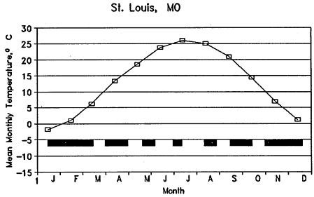
FIGURE 5.1 Mean monthly temperature of St. Louis, Missouri, and the length of continuous saturation required to develop anaerobic conditions in the root zone at various times of year, as shown by the length of solid bars (W Skaggs, unpublished data).
ence the rate at which anaerobic conditions or plant responses develop, however, no simple estimate is likely to be realistic. Furthermore, current data are inadequate to define the duration threshold for saturation of wetlands over the wide range of soils, climates, and wetland types in the United States. Information is available for some regions, however, and duration thresholds can be approximated from information on the tolerance of a few sensitive upland plants to flooding and saturation. More research is needed on relationships of the duration of saturation to the development of wetland soils and vegetation, from which a more flexible, temperature-based adjustment of the duration threshold can be derived.
Definitions of Growing Season and Their Application to Wetlands
Cowardin et al. (1979) define the growing season as the frost-free portion of the year, but they apply the concept only to saturation or inundation of nonsoil substrates. The 1987 Corps manual applies the concept to inundation or saturation of soil, rather than of nonsoil substrates. The manual uses the growing season through its adoption of the definition of hydric soils from the National Technical Committee for Hydric Soils (Chapter 4). Growing season has thus
evolved from a minor constraint on the classification of nonsoil substrates to a major consideration in the identification of vegetated wetlands generally.
The most common use of the growing season concept is in agriculture. While information on growing season for crops may be useful in evaluating wetlands, the growing season concept as applied to wetlands relates specifically to wetland organisms (especially vascular plants), and not to crops.
Growing season has been defined as the period during which a given soil temperature at a specified depth is exceeded or as some function of the frost-free portion of the year. The 1987 Corps manual uses both definitions (Chapter 4). The 1988 Environmental Protection Agency (EPA) manual similarly defines growing season by its reference to biological zero (41°F, 5°C), but it does not mention frost-free days. Essentially the same approach appears in the 1989 interagency manual. A different definition appears in the 1991 proposed revisions, which define growing season as the interval from 3 weeks before to 3 weeks after killing frost, with exceptions for: "areas experiencing freezing temperatures throughout the year (e.g., montane, tundra, and boreal areas) that nevertheless support hydrophytic vegetation." The 1991 proposed revisions thus recognize errors in treatment of perennial cold regions as one of the flaws in earlier definitions of growing season (Bedford et al., 1992). In fact, the concept of biological zero, which is inherent in the use of growing season to define the metabolic activity of soils and plants, leads to numerous problems.
Biological Zero
The idea of biological zero is based on the notion that a limit of biological activity occurs at a specific temperature, below which, as stated in the 1987 Corps manual, "metabolic processes of soil microorganisms, plant roots, and animals are negligible." That manual places the temperature at 41°F (5°C), measured at a depth of about 20 in. (50 cm). This threshold fails for wetland communities in cold regions (Ping et al., 1992), and it might fail for some temperate communities as well (Disc, 1992). Furthermore, many wetland plants root at shallower depths (Tiner, 1991b; Bedford et al., 1992), which limits the relevance of soil temperature at this depth. Currently, the Hydric Soils List refers to the growing season as "the portion of the year when soil temperatures are above biologic zero in the upper part." This is more realistic than reference to 20 in. (50 cm), but "upper part'' is not defined.
The use of biological zero is particularly inappropriate for defining growing season in permafrost wetlands. Pergelic Cryaquepts, which with histic Pergelic Cryaquepts (Appendix A, Soil Taxonomy) make up 65% of currently described permafrost soils in Alaska (Moore et al., 1993), have mean annual soil temperatures of ![]() with active layers (seasonally thawed zones) averaging 20 in. (50 cm) and rarely exceeding about 3 ft (1 m) in thickness (Ping et al., 1992). Temperatures in the saturated zone often are only slightly greater than 0°C during
with active layers (seasonally thawed zones) averaging 20 in. (50 cm) and rarely exceeding about 3 ft (1 m) in thickness (Ping et al., 1992). Temperatures in the saturated zone often are only slightly greater than 0°C during
the warmest weeks. For example, according to the 1989 interagency manual, Barrow, Alaska, would have a growing season of 0 days. The biological zero concept as developed for wetlands leads to the conclusion that shallow permafrost soils have no growing season, which runs counter to the reality that tundra and taiga ecosystems flourish on such soils.
Native plant species adapted to cool temperate, boreal, arctic, and alpine environments remain physiologically active at soil temperatures below biological zero (Tiner, 1991b; Bedford et al., 1992). Below-ground parts of arctic plants grow at biological zero (McCown, 1978, in Chapin et al., 1980; Chapin and Shaver, 1985) and absorb nutrients at low temperatures (Chapin and Shaver, 1985). Roots of deciduous taiga trees respire actively at 41°F (5°C) (Lawrence and Oechel, 1983), and their ability to absorb phosphate is relatively insensitive to temperature (Chapin, 1986).
Plant growth above ground also occurs at low soil temperatures, even under snow cover (subnivean). Arctic, alpine, and montane plant species grow (Billings and Bliss, 1959; Kimball et al., 1973; Kimball and Salisbury, 1974; Salisbury, 1984), flower (Bliss, 1971), or compete (Egerton and Wilson, 1993) in the subnivean environment at soil temperatures near freezing. Even in northern hardwood forest, spring-flowering herbs can develop leaves when soil temperatures are near 32°F (0°C) and there is partial snow cover (Vézina and Grandtner, 1965). Evergreen shrubs on exposed sites photosynthesize when the root zone is frozen (Webber et al., 1980), mosses and tundra graminoids photosynthesize when not covered by snow, and graminoids and the shrub Dryas initiate growth and photosynthesis within 1 day of snowmelt (Tieszen et al., 1980).
Tundra plants achieve high rates of production (Chapin et al., 1980) because their photosynthetic optima are from 18° to 54°F (10° to 30°C) below those of plants in temperate regions, and they often maintain significant rates of photosynthesis to 25°F (-4°c) (Chapin and Shaver, 1985). Some tundra and taiga mosses and lichens photosynthesize at >50% of maximum rates at 32°F (0°C) or 41°F (5°C) (Tieszen et al., 1980; Chapin and Shaver, 1985; Oechel and Lawrence, 1985). Other biological activity outside the frost-free period includes photosynthesis in alpine plants, subnivean growth of at least 20 plant species (including two winter annual cereals) at snowpack temperatures ![]() (Salisbury, 1984), regreening of leaves and growth of roots in taiga plants (Kummerow et al., 1983; Tryon and Chapin, 1983), and growth of shoots in a temperate sedge (Bedford et al., 1988). Similarly, cyanobacteria associated with taiga lichens and bryophytes fix nitrogen at 38°F (3.5°C) (Alexander and Billington, 1986) and can be active for nearly 1 month after the average date of the first frost. Intact cyanobacterial crusts from subalpine habitats show no reduction in nitrogenase activity after repeated freeze-and-thaw cycles, and cyanobacterial nitrogenase activity of sedge meadow cores from a high arctic lowland are nearly 30% of maximum at 39°F (3.7°C) (Chapin et al., 1991).
(Salisbury, 1984), regreening of leaves and growth of roots in taiga plants (Kummerow et al., 1983; Tryon and Chapin, 1983), and growth of shoots in a temperate sedge (Bedford et al., 1988). Similarly, cyanobacteria associated with taiga lichens and bryophytes fix nitrogen at 38°F (3.5°C) (Alexander and Billington, 1986) and can be active for nearly 1 month after the average date of the first frost. Intact cyanobacterial crusts from subalpine habitats show no reduction in nitrogenase activity after repeated freeze-and-thaw cycles, and cyanobacterial nitrogenase activity of sedge meadow cores from a high arctic lowland are nearly 30% of maximum at 39°F (3.7°C) (Chapin et al., 1991).
Soil microbes also are active in tundra and taiga wetlands when the soil
temperature is below biological zero. Bacteria from tundra soils respire to 20° or 19°F (-6.5° or -7°C) (Flanagan and Bunnell, 1980). Fungal biomass can increase within a temperature range of 32° to 26°F (0° to 2°C), but growth generally ceases below 27°F (-3°C) (Bunnell et al., 1980; Flanagan and Bunnell, 1980). Further evidence for microbial activity below nominal biological zero includes the presence of cold-adapted fungi in cold, acidic peat soils (Grishkan and Berman, 1993); in greater respiration rates and larger populations of some taiga microbes at 39°F (4°C) than at 68°F (20°C) (Sparrow et al., 1978); in overwinter increases in microbial biomass in near-freezing taiga soils (Zolotareva and Demkina, 1993); and in substantial early-winter carbon dioxide emissions from tundra and taiga soils (Zimov et al., 1993). The unfrozen isothermal zone (32°F [0°C]) that persists in the active layer of permafrost soils until heat loss is sufficient for phase change could provide a favorable environment for microbial activity (Zimov et al., 1993). Microbes oxidize >25% of estimated annual carbon fixation in a Wyoming subalpine meadow at winter soil temperatures of 33° to 35°F (0.5° to 1.5°C) (Sommerfeld et al., 1993). Wastewater treatment facilities, including natural and constructed wetlands subjected to wastewater discharge, also demonstrate significant microbial activity at low temperatures (S.E. Clark et al., 1970; Eckenfelder and Englande, 1970; Pick et al., 1970; Vennes and Olsson, 1970; Henry, 1974; Kent, 1987; Miller, 1989).
Hydric soils develop when soil microbial activity depletes oxygen and creates reducing conditions. Methane emission from saturated tundra and taiga soils demonstrates reducing conditions and suggests that these soils can become anoxic at temperatures below biological zero (Svensson, 1983, in Svensson and Rosswall, 1984; Whalen and Reeburgh, 1992). Winter methane fluxes from Minnesota peatlands (Disc, 1992) also provide evidence for reducing conditions in cold soils. Low redox potentials (in this case, <100 mV) were documented at groundwater temperatures below 39°F (4°C) at two tundra bioremediation sites (Jorgenson and Cater, 1992; Jorgenson et al., 1993). A great deal of evidence from field and laboratory studies shows that biological activity occurs below 41°F (5°C), especially in cold regions. This casts doubt on the validity of any universal value for biological zero.
Growing Season as Defined by the Frost-Free Period
The use of a "mean frost-free period" poorly represents the occurrence of soil and air temperatures at which biological activity can occur in arctic, subarctic, alpine, and some temperate regions. Wide interannual variability in the number of frost-free days at locations as diverse as Iowa (Bedford et al., 1992), coastal British Columbia (Banner et al., 1986), and interior Alaska (Bowling, 1984) suggests that in many years biological activity occurs over a period considerably longer than that defined by the average number of frost-free days. Growing season as defined by the frost-free period is particularly problematic in arctic
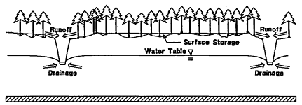
FIGURE 5.2 Drained wetland.
tundra, where subfreezing temperatures can occur at any time of year (Savile, 1972; Chapin and Shaver, 1985). Barrow, Alaska, for example, annually averages 16 frost-free days (Sharratt, 1992), but has 91 days with a mean daily air temperature above freezing (Brown et al., 1980). Similarly, a subarctic site has been shown to have a frost-free growing season of 97 days (Slaughter and Viereck, 1986) and a thaw season of about 176 days (Dingman, 1971). Subfreezing temperatures occur daily in equatorial alpine communities (Bliss, 1971; Beck, 1987, in Kalma et al., 1992), and they occasionally occur early in the growth period in midlatitude alpine plant communities (Billings and Bliss, 1959; Holway and Ward, 1965).
Interaction of Duration Threshold with Length of Growing Season
The appropriate duration threshold for the saturation of soils in wetlands depends on the definition of growing season. An analysis of growing season for a specific site will illustrate this point. The hydrology of a hypothetical drained wetland (Figure 5.2) was analyzed with the simulation model DRAINMOD, using the methods described by Skaggs et al. (1994). Analyses were conducted for a sandy loam hydric soil with a constant drainable porosity of 5%, parallel drainage ditches about 4 ft (1.2 m) deep and about 330 ft (100 m) apart, and average depressional storage of about 1 in. (25 mm). The drainage intensity was varied by changing the hydraulic conductivity of the soil profile which is about 8 ft (2.4 m). The hydrology was simulated over a 40-year period (1953-1992) by use of climatological data for Plymouth, North Carolina. The growing season, based on the average last date of 28°F (-2.2°C) in the spring and average first date of 28°F (-2.2°C) in the fall, is Mar. 30 to Nov. 7, or 222 days. Thus, the hydrologic requirement for a wetland, according to the 1987 Corps manual, is 11 days (5% of 222 days).
The number of years that exceed the 11-day duration threshold for saturation during the growing season is shown in Figure 5.3a as a function of hydraulic
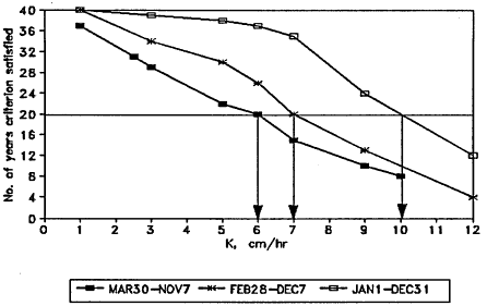
FIGURE 5.3(a) Results of a simulation for a wetland in Plymouth, North Carolina. The graph shows the effect of hydraulic conductivity and length of growing season on the number of years that the water table depth is less than 30 cm (11.7 in.) for at least 11 consecutive days during the growing season. The graph shows that critical permeabilities for the wetland threshold increase as the length of the growing season increases.
conductivity (K). Hydraulic conductivity of 2.34 in./hour (6 cm/hr) would cause the threshold to be exceeded in 20 of 40 years, which would just qualify the site as a wetland by the conventions of the 1987 Corps manual. Results differ if the 11-day threshold is evaluated over longer portions of the year. For example, if the whole year is considered, the 11-day threshold would be met or exceeded in 36 of 40 years for K = 2.34 in./hour (6 cm/hr). Increasing the length of the growing season without adjusting the duration threshold thus causes drier sites (with higher K) to meet a given duration threshold.
The result of holding the critical duration as a fixed percentage (5%) of the growing season, as is the convention of the 1987 USACE manual, is shown in Figure 5.3b. In this case, the critical durations for various hypothetical growing seasons were Mar. 30 to Nov. 7 growing season (duration, 11 days); Feb. 28 to Dec. 7 growing season (14 days); and the whole year (18 days), Thus, when duration is defined as a percentage of the growing season, the characterization of the site is to some extent normalized. If the entire year were treated as a growing season, however, some relatively dry sites would still tend to exceed the hydrologic threshold.
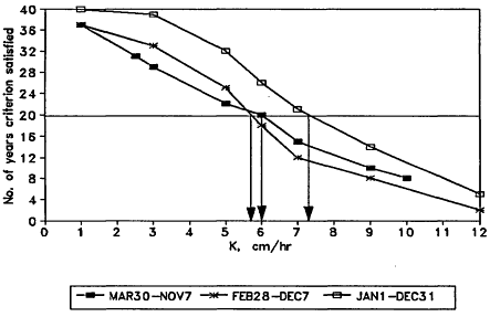
FIGURE 5.3(b) Effect of hydraulic conductivity and growing season on the number of years that the water table depth was less than 30 cm (11.7 in.) for 5% of the growing season for the simulation of a wetland in Plymouth, North Carolina.
Resolving the Problem of Growing Season
Two general possibilities exist for resolving the problems caused by use of growing season in the identification of wetlands. The first is to abandon growing season as a constraint on the duration threshold for inundation and saturation and replace it with a system that links duration directly with temperature. The other is to redefine the growing season by region on the basis of careful scientific study of natural wetland communities and processes. The continuous change of plant and microbial activity with temperature provides a strong argument for the first approach (Tiner, 1991a; Bedford et al., 1992), but more thorough study of the physiologic activity of vegetation, soil microbes, and fauna in reference wetlands could permit the latter. Either approach would recognize more effectively the regional variation in duration thresholds.
Weaknesses in the growing-season concept, particularly for cold soils in which considerable metabolic activity can occur outside the present growing season, have already been summarized. In addition, estimates of the duration threshold are probably too short for places with long growing seasons. For example, Faulkner and Patrick (1992) analyze redox processes, water table depth, and wetland soil indicators on 24 bottomland hardwood forest sites over a range of elevations in Louisiana and Mississippi. For those sites, a change in the water
table duration threshold for hydric soils from >7 days to >14 days would be justified, especially if saturation occurs early in the growing season when soil temperatures are low enough to slow microbial reduction. A similar study in South Carolina (Megonigal et al., 1993) reports that soils with hydric soil indicators within 1 ft (30 cm) of the surface were saturated at nearly 6 in. (15 cm) for at least 30 days. In this study, as well as the one by Faulkner and Patrick, the absence of sites saturated for shorter durations limits interpretation of events at the drier end of the moisture gradient.
More studies are needed in other regions and for other physiographic settings and wetland types, whether the use of the growing-season concept continues or is replaced by a more flexible time-and-temperature concept. In some cases, computer simulation models could be combined with field data to analyze the long-term hydrology of sites along the gradient from wetland to upland. In this way, soils and vegetation could be correlated with frequency and duration of saturation over the long term for specific regions or wetland types. This could expedite the refinement of duration thresholds.
Evaluation of duration thresholds for wetlands requires long-term data on water table depth and corresponding information on soil morphology and vegetation across a range of conditions. The lack of such data, except for a few locations, has limited development and refinement of thresholds in support of the hydrologic criterion. For some wetlands, simulation models can be used to predict water table fluctuations over long periods.
This approach was used by Skaggs et al. (1994) in evaluating seven proposed interpretations of the hydrologic criterion, including those of the federal manuals. The analysis showed that thresholds in the 1991 proposed revisions—flooding for 15 consecutive days or saturation to the surface for 21 consecutive days—characterize lands that are much wetter than those consistent with the 1987 or 1989 manuals. According to the simulation, the threshold given by the 1987 manual (water table <1 ft [30 cm], 14 consecutive days) would, for the North Carolina coastal plain, give corn yields that are approximately equal to observed average yields for standard agricultural drainage practice.
Frequency of Saturation
Delineation manuals for wetlands have not only specified thresholds for duration of saturation or flooding, but they also have incorporated the concept of "normal circumstances" or "average conditions." Average conditions are usually interpreted to mean those with a 2-year recurrence interval, or once in 2 years on average (10 out of 20 years). The threshold frequency for inundation probably varies, however, as a function of duration, especially in the western United States. For example, hydric soils form on sites that are saturated, flooded, or ponded long enough to develop anaerobic conditions. This might occur on sites that are anaerobic and reducing for brief periods nearly every year or on sites that are
saturated and anaerobic for long periods, but not every year (such as the prairie pothole region). Similar reasoning applies to the interactions of duration and frequency essential for support of hydrophytic vegetation. In general, the duration threshold for saturation would increase as the frequency of saturation decreases. There is little scientific information on the relationship, however.
Critical Depth of Saturation
The rationale for determining the depth at which saturation should be evaluated is the response of plants to saturation of the substrate. Plants that are not adapted to frequent or extended periods of saturation within their rooting zones cannot survive in wetland environments. The depth of saturation, therefore, should be based on the depth of wetland plant roots. Only if saturation occurs within the plant rooting zone will it affect the establishment of wetland vegetation.
The few studies that have documented the depth distributions of roots in wetlands show that most roots are concentrated in the upper 1-2 ft (30-60 cm). Costello (1936) reports the rooting depths of several species growing in tussock meadows in Wisconsin. Arrowhead (Sagittaria latifolia) and Carex riparia (C. lacustris) rooted in the top 8 in. (20 cm) but that the tussock sedge (C. stricta) penetrated to 2 ft (60 cm). In a study of 15 annual and perennial species from freshwater tidal marshes, Whigham and Simpson (1978) found that all of the species except Peltandra virginica rooted in the upper 2 ft (60 cm) of substrate. Lieffers and Rothwell (1987) found that the roots of black spruce (Picea mariana) and tamarack (Larix laricina) were almost entirely restricted to the top 1 ft (30 cm) of substrate. Day and Montague (1980) found that in the Great Dismal Swamp most roots occur within the top 1 ft (30 cm) of the surface. In a study of several species common in fens (minerotrophic peatlands), Sjors (1991) found that, although some roots penetrate nearly 2 ft (60 cm), most roots and rhizomes concentrate in the upper 1 ft (30 cm). Although roots of some plants, and particularly trees, may extend more deeply than 1 ft (30 cm), the presence of an unsaturated zone above 1 ft (30 cm) may provide sufficient oxygen to meet the needs of most plants. Thus, evidence supports a depth of 1 ft (30 cm) as the critical zone for assessment of saturation, but further studies are clearly needed.
Interannual Variation
Variation in wetness from season to season and from year to year causes difficulties in identifying and delineating wetlands. This is especially true for sites that have been modified to such an extent that soils and vegetation are not reliable indicators of hydrologic status. Plant species can change from year to year in response to higher or lower water levels. For this reason, seed banks could provide valuable information on characteristic conditions. Temporal varia-
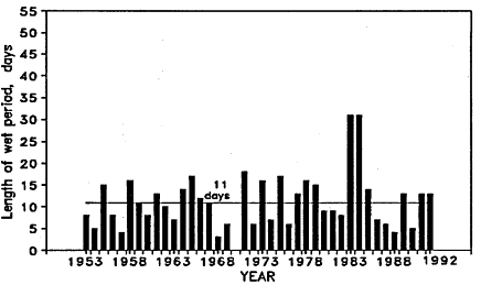
FIGURE 5.4 Length of longest continuous period that the water table depth would be less than 1 ft (30 cm) for a site that satisfies the duration threshold for saturation in 20 of 40 years, as simulated by DRAINMOD from climatological data from Plymouth, North Carolina.
tion of soil water is a typical result of variation in precipitation and evapotranspiration, but variation is more extreme in some regions than in others. On floodplains of large rivers, for example, the source of variation could be temporal variability of weather over a large region, whereas isolated wetlands could be affected by local variations. Variation also can be affected by structures such as dams or dikes.
An example of interannual variation in water table depth can be taken from a simulation for a site on sandy loam near Plymouth, North Carolina (Skaggs et al., 1991). The simulation was designed so that the duration threshold for wetlands as given by the 1987 Corps manual was just satisfied, which would require that the water table be within 1 ft (30 cm) of the surface for 5% of the growing season (5% of 222, 11 days) for half of the years. The longest span of days for any given year that the water table was within 1 ft (30 cm) of the surface during the growing season is shown in Figure 5.4 for each year of the 40-year simulation period (1951-1990). Although the site exceeded the hydrologic threshold for wetlands in 1 of 2 years, on average, there were several periods of 2 or 3 consecutive years when it did not exceed the threshold. In 2 years the water table was near the surface for more than 30 days; in several others it was in the top 1 ft (30 cm) of the profile for fewer than 5 days. These results demonstrate the limitations of short-term field data on borderline sites.
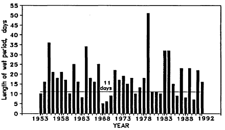
FIGURE 5.5. Length of longest continuous period that the water table depth is less than 1 ft (30 cm) for a site that satisfies the duration threshold for saturation in 30 of 40 years, as simulated by DRAINMOD from climatological data from Plymouth, North Carolina.
Year-to-year variability is a less serious problem for sites that are clearly wetland or upland. Simulation results for sites that exceed the hydrologic threshold in 75% (wetland) and 25% (nonwetland) of the years are given in Figures 5.5 and 5.6. For the wetter site (wetland), most years that do not show 11 consecutive days of saturation would have wet periods of within 2 or 3 days of that number. There is still one 3-year period (1968-1970), however, during which the threshold would not be exceeded. The drier site (nonwetland) would be below the threshold in most years but would occasionally exceed the threshold for 2 or 3 successive years (Figure 5.6). The simulations illustrate the influence of interannual variation on the hydrology of wetland sites. Analyses based on short-term water table data must consider antecedent and current precipitation and evapotranspiration as they relate to long-term patterns. Interannual variation increases as annual precipitation decreases.
Overview of Hydrologic Thresholds
There is not yet enough information about wetland hydrology and the response of soils, plants, and other wetland organisms to saturated soil to support a complete description of the conditions that demonstrate the presence of wetland hydrology for all soils, climates, and wetland types. Hydrologic thresholds can be estimated roughly, however, from the range of specific hydrologic conditions associated with wetland soils (Gilliam and Gambrell, 1978; Faulkner and Patrick,
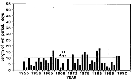
FIGURE 5.6. Length of longest continuous period that the water table depth is less than 1 ft (30 cm) for a site that satisfies the duration threshold for saturation in 10 of 40 years, as simulated by DRAINMOD from climatological data from Plymouth, North Carolina.
1992; Megonigal et al., 1993) and wetland organisms (Niering, 1985) and from moisture tolerances of upland plants (Joshi and Dastane, 1955; Luxmore et al., 1973; Howell et al., 1976; Carter, 1977; Evans et al., 1990, 1991). The data now available indicate that reasonable hydrologic thresholds would include a depth to water table of <1 ft (30 cm) for a continuous period of at least 14 days during the growing season, with a mean interannual frequency of 1 out of 2 years. This threshold is consistent with those defined for the formation of hydric soils (USDA, 1991) and would fall within the range of the convention used in the 1987 Corps manual of 5-12% of the growing season, except for those areas with growing seasons >280 days (such as southern California) or <112 days (such as Alaska). Overriding regional thresholds should be set for these areas.
The use of numeric thresholds for hydrology has been criticized because anaerobic conditions can develop within 1 or 2 days of flooding (Tiner, 1993). Although this can occur, the hydrologic threshold defines the limiting condition rather than the characteristic conditions. A natural system that quickly develops anaerobic conditions would likely satisfy the hydrologic requirements imposed by other indicators (by inference from hydrophytic vegetation). An extended period of saturation is required for anaerobic conditions to develop in soils that are infrequently saturated, especially if saturation occurs early in the growing season when soil temperatures are low. More scientific information is needed especially for areas where saturation itself, rather than anoxia, is responsible for the presence of hydrophytes.
Direct Methods for Evaluating Hydrology
Direct determination of the wetland boundary can be made by water table measurements along lines or transects of observation wells over 1 or more years, in combination with a hydrologic analysis that considers current and long-term average weather. Measuring the depth to the water table or the height of standing water is relatively easy. Pressure transducers and floats are routinely used to record water levels in wells (Freeze and Cherry, 1979). Although a water level record over a single year, which is sufficient to cover major seasonal hydrologic changes, might suffice, a longer record would be needed for cases that marginally satisfy the hydrologic requirements for duration of saturation and for sites with high interannual variation, especially in semiarid regions of the country.
A second direct method is the use of aerial photographs or spectral information, such as infrared images that document flooding. Spectral data or aerial photographs taken at the right time of year, coupled with measurements of precipitation and duration of flooding, are good indicators of wetland hydrology. Such information, however, documents inundation or saturation at the surface, and not saturation near the surface. Furthermore, it is necessary to have such information at a frequency sufficient to determine the length of the inundation.
One method of interpreting short-term (1-year) hydroperiod records would be to establish wetland reference sites that are subject to the same conditions and variations of climatology as are the sites being evaluated. Water table data could then be compared with data from the reference site; the comparison would show whether the test site is wetter or drier than the reference site. A disadvantage of this approach is that reference wetlands would be needed for many wetland types and for many locations.
Indirect Methods for Evaluating Hydrology
Indirect determinations of flooding or saturation can be made by observation or by calculation. As already explained, the strongest indirect evidence of wetland hydrology, if hydrology has not been altered, would be from hydric soils or hydrophytic vegetation. Other indirect hydrologic indicators include adaptations of vegetation to saturated conditions (multiple and buttressed tree trunks, adventitious roots, shallow root systems, polymorphic leaves, hypertrophied lenticels, inflated leaves and aerenchyma tissue). Unless relationships between the duration of saturation and the deuce of plant tissue adaptation have been established for a particular region, however, such adaptations can be used as evidence for wetland hydrology only in support of more definitive indicators of hydrology, such as the presence of hydric soils or hydrophytes.
Other physical evidence of flooding includes. silt marks, drift lines, surface scour, and channels. Extended surface flooding also causes fallen leaves to blacken. These phenomena, however, only indicate discrete hydrologic events
and not long-term hydrologic conditions. They do not provide information on the duration and timing of inundation, which are the critical hydrologic factors that determine whether a landscape develops wetland characteristics.
Mathematical models also can be effective in evaluating the hydrologic features of a landscape. Models such as DRAINMOD (Skaggs, 1978; Skaggs et al., 1991) and SWATRE (Feddes et al., 1978) can be used to calculate the effects of hydrologic modifications (such as drainage ditches) on water table depth if they are used with long-term data on meteorology. Models also can be used to determine whether short-term measurements of water table and surface water elevations represent ''normal'' conditions.
Although models are powerful tools, their reliable application depends on specialized training and usually requires considerable data on soil properties and meteorology. Simulation models have been tested for some wetland types, but not for others. For this reason, modeling should not be viewed as a routine alternative to direct measurements. It might be possible, however, to use simulation models to prepare reference hydroperiods that include the effects of current and antecedent meteorological conditions. The recommendations from this section of the chapter are listed as recommendations 1 through 10 at the end of this chapter.
SOILS
Because the presence of hydric soil is the most common and useful general indicator to support the substrate criterion for wetlands, definitions and descriptions of hydric soils are of great practical importance to the identification and delineation of wetlands. Although soils are now used routinely in the diagnosis of wetland conditions, several scientific and technical issues require further study and refinement. Especially important are the conventions for identifying hydric soils under field conditions. It is also important that research continue to illuminate the conditions that lead to formation of hydric soils. Some wetlands may lack hydric soils (or lack soils altogether). Where hydric soils do occur, they are diagnostic of wetlands, unless hydrology has changed since they formed.
Concepts of Soil
Soil scientists define soil as (Soil Survey Staff, 1975)
the collection of natural bodies on the earth's surface ... of earthy materials, containing living matter and supporting or capable of supporting plants out-of-doors. Its upper limit is air or shallow water. At its margins it grades to deepwater or to barren areas of rock or ice.
The distinguishing features of this definition are that a soil is capable of supporting plants and that Soil can be covered by "shallow water" but not by
"deepwater." This definition differs from the one used in geology, for which all unconsolidated materials above bedrock are considered soil (Bates and Jackson, 1987).
Soil scientists distinguish between rock-weathering processes that generate small particles of earthy material (beach sands, mud flats, river and lake bottom sediments, recently deposited alluvium, glacial rock flour), and soil-forming processes by which particles are altered over time through the interactions among climate, relief, parent material, and living organisms (Soil Survey Staff, 1992).
Until very recently, many wetlands were not considered to contain soil at all because of the sharp distinction made by soil scientists between rock weathering and soil formation. Soil-mapping conventions used between 1951 and 1993 (Soil Survey Staff, 1951), labeled many wetlands "miscellaneous land types"—lands that have little or no natural soil. Included in this category were alluvial land, beach, marsh, tidal marsh, fresh water marsh, salt water marsh, playa, swamp, tidal swamp, fresh water swamp, tidal swamp (mangrove), fresh water swamp (cypress), and tidal flat (Soil Survey Staff, 1951, pp. 306-311). Most of the nation's soil surveys were prepared by use of these conventions. Currently, beaches and playas are the only wetland-related features that remain in the miscellaneous land category (Soil Survey Staff, 1993, pp. 41-44). Also, areas that are permanently covered by water so deep that only floating plants are present are still not considered to have a substrate that is soil (Soil Survey Staff, 1993).
According to the Natural Resources Conservation Service (NRCS), "hydric soil" is a type of "technical soil grouping" that was developed "for the application of national legislation concerned with the environment and with agricultural commodity production" (Soil Survey Staff, 1993). Soils with ''aquic conditions" experience continuous or periodic saturation and reduction (Soil Survey Staff, 1992). Soils with an ''aquic moisture regime" are virtually free of dissolved oxygen due to saturation by ground water or by water of the capillary fringe (Soil Survey Staff, 1992). These and other terms used to describe and classify wet soils are discussed further in this chapter and in Appendix A.
Soil-Forming Processes in Wetlands
Accumulation of Organic Matter
Organic matter, which darkens the color of soil, tends to accumulate in wetlands because of the imbalance between primary production and decomposition (Mausbach and Richardson, 1994). Histosols are soils derived from organic matter, and they occur almost exclusively in wetlands (the exception being Folists, a very uncommon Histosol derived from decomposed leaves). Histic epipedons are surface layers of organic matter that reliably indicate hydric soils in the field, provided that they are correctly distinguished from other types of dark epipedons that are not reliable indicators. For example, soils with mollic epipedons (prairie
soils) contain accumulated organic matter, but might or might not occur in wetlands. They are identified as problem soils in the 1989 manual.
Development of Anaerobic Conditions
Saturation of the pore space between soil particles decreases the movement of oxygen into the soil from the atmosphere, but biological activity that requires oxygen in the soil continues after saturation. As a result, soils that are saturated with water for many days typically become anaerobic—their free oxygen disappears and they show a decline in oxidation-reduction (redox) potential (Eh). Soils with an ![]() are generally considered to be anaerobic (reduced), but this threshold varies with soil pH. After soil oxygen becomes depleted, anaerobic microorganisms use other compounds in redox reactions, including manganese, iron, and sulfate. Factors that affect the development of anaerobic conditions include oxygen supply, abundant electron donors, and temperature.
are generally considered to be anaerobic (reduced), but this threshold varies with soil pH. After soil oxygen becomes depleted, anaerobic microorganisms use other compounds in redox reactions, including manganese, iron, and sulfate. Factors that affect the development of anaerobic conditions include oxygen supply, abundant electron donors, and temperature.
Laboratory studies that are well-mixed soil-and-water slurries and supplemental organic carbon have shown depletion of soil oxygen in as little as 1 day (Turner and Patrick, 1968), but field studies indicate that oxygen depletion typically takes much longer than this in undisturbed wetland soil. Slow decline of oxygen is probably the rule where the organic content of soil is low. Vepraskas and Wilding (1983) show that a Texas coastal plain soil (Segno fine sandy loam: Typic Paleudalf) that was low in organic matter (<1%) was saturated from mid-February to early May before becoming sufficiently anoxic for reduction of iron to occur. Also, Faulkner and Patrick (1992) show that a Kobel soil (Vertic Haplaquept) supporting bottomland hardwood wetland vegetation was anaerobic (![]() ) for fewer than 7 days during the growing seasons of 1984 and 1985, even though it was saturated (water table depth
) for fewer than 7 days during the growing seasons of 1984 and 1985, even though it was saturated (water table depth ![]() [30 cm] below the soil surface) for 77-78 days during the same 2 years. The water table for the Kobel soil was measured at these intervals and was generally exactly at 11.8 in. (30 cm) or just above. If a water table measurement exceeded the 12.2 in. (31 cm) threshold for two or more consecutive measurements, then the water table was considered to be
[30 cm] below the soil surface) for 77-78 days during the same 2 years. The water table for the Kobel soil was measured at these intervals and was generally exactly at 11.8 in. (30 cm) or just above. If a water table measurement exceeded the 12.2 in. (31 cm) threshold for two or more consecutive measurements, then the water table was considered to be ![]() in. (30 cm) for all intervening days. It is likely that the water table at this site was below the 11.8 in. (30 cm) depth during the intervening days which allowed that depth to become aerobic. Therefore, the large discrepancy between anaerobic and saturated conditions for the Kobel and Norwood soils are likely artifacts of the methods. In the same study, Tensas (Aeric Ochraqualf) and Norwood soils (Typic Udifluvent) were saturated for 7-14 days without becoming anaerobic. This study (Faulkner and Patrick, 1992) was not, however, designed to determine the minimum time for development of anaerobic conditions. Because measurements were made only twice monthly in the spring, the large discrepancies between anaerobic and saturated conditions may be in part an artifact of the long interval between sampling dates. In the
in. (30 cm) for all intervening days. It is likely that the water table at this site was below the 11.8 in. (30 cm) depth during the intervening days which allowed that depth to become aerobic. Therefore, the large discrepancy between anaerobic and saturated conditions for the Kobel and Norwood soils are likely artifacts of the methods. In the same study, Tensas (Aeric Ochraqualf) and Norwood soils (Typic Udifluvent) were saturated for 7-14 days without becoming anaerobic. This study (Faulkner and Patrick, 1992) was not, however, designed to determine the minimum time for development of anaerobic conditions. Because measurements were made only twice monthly in the spring, the large discrepancies between anaerobic and saturated conditions may be in part an artifact of the long interval between sampling dates. In the
Willamette River Valley of Oregon, long periods of soil saturation do not always result in anoxic conditions (Austin, 1993).
Daniels and Buol (1992) suggest that there are periods each year when low concentrations of dissolved organic carbon in soil water limit the rate of reduction reactions. Obenhuber and Lowrance (1991) found little evidence of microbial growth when dissolved organic carbon was below 4 mg/L. Daniels et al. (1973) found that some Ultisols are not reduced even when the temperature is above 41°F (5°C) and water is standing at the surface. Reducing conditions did not occur at a depth of about 3 ft (100 cm) in soils of the Willamette Valley, despite saturation for more than 50% of the wet season, because of low amounts of organic matter (Austin, 1993). The influence of organic carbon on soil redox conditions also has been shown in field studies by Ransom and Smeck (1986) and Meek et al. (1968) and in laboratory experiments by Bloomfield (1950; 1951), Ponnamperuma (1972), Gilliam and Gambrell (1978), Reddy et al. (1982), and Farooqi and deMooy (1983). Research on groundwater systems has shown that some microbes use hydrogen in lieu of carbon compounds as electron donors (Smith et al., 1994), but it is not known whether this occurs in wetlands.
Because most wetlands have an abundant supply of organic carbon from vegetation, prolonged saturation typically leads to anaerobiosis (McKeague, 1965; Vepraskas and Wilding, 1983; Ransom and Smeck, 1986; Josselyn et al., 1990; Faulkner and Patrick, 1992; Naiman et al., 1994). This issue requires more study, particularly for wetlands in arid climates where saturated soils commonly have only small amounts of organic carbon. Examples of such wetlands include playas, vernal pools, and parts of riparian zones in the western United States.
Anaerobic conditions develop more slowly in cold soils than they do in warm ones (Updegraff et al., 1995). For example, experiments on the surface layer of a hydric soil (Cape Fear, Typic Umbraquult) under controlled temperatures in the laboratory by Gilliam and Gambrell (1978) showed that 30 days' saturation was required to reach reducing conditions (Eh = 350 mV) at 77°F (25°C) as compared with 60 days at 59°F (15°C). The same soil at 41°F (5°C) did not reach reducing conditions in the 60-day experiment. Similar experiments on an upland soil resulted in reducing conditions after 5 days at 77°F (25°c), at 28 days at 59°F (15°C), and at 58 days at 41°F (5°C). It generally has been assumed that microbial activity and accompanying reduction reactions cease when soil temperatures are below 41°F (5°C) during the period of saturation (Soil Survey Staff, 1975; Pickering and Veneman, 1984), but several studies have demonstrated significant microbial activity at temperatures below 41°F (5°C). Furthermore, horizons with low chroma indicative of iron reduction occur in most mineral permafrost soils in the Canadian soil classification system (7 of 8 subgroups), and in several Alaskan permafrost soils. Therefore, it appears that the use of 41°F (5°C)—biological zero—as the threshold temperature below which anaerobiosis cannot develop is scientifically questionable.
Plants can sometimes affect the development of anaerobic conditions through
evapotranspiration. In California, aerobic conditions can occur in the top layer of wetland soils despite high groundwater tables during the spring because soil moisture is removed by evapotranspiration (Josselyn et al., 1990). A similar effect can occur in moist climates (Appendix B, Kirkham Wetlands case study). Some soils retain oxygen when they are saturated because oxygenated water enters the soil continuously.
Redoximorphic Features
Redox reactions involving iron and manganese cause distinctive color variations in mineral soils that are subjected to continuous or recurrent anaerobiosis. Formerly called "gleying" and "mottling," these color variations are now called "redoximorphic features" (Appendix A). Ferric (oxidized) iron compounds generally exhibit high-chroma (bright) yellowish to reddish hues, whereas ferrous (reduced) compounds are green, blue, or have low chroma (they are grey). Periodic saturation of soils causes alternation of reduced and oxidized conditions. During saturation, iron is reduced to the ferrous form, which is soluble and can be translocated in the soil by water movement. During drainage, oxygen enters the soil and the ferrous iron is oxidized back to the ferric form, which precipitates in the soil because of its insolubility. Recurrence. of this cycle over many decades concentrates these bright, insoluble ferric compounds. These ''redox concentrations" (formerly called mottles) usually persist for decades, even if the conditions under which they formed have changed.
Distinctive color features also can form in similar ways near plant roots in anaerobic soils. If wetland plants are growing in soils where iron compounds have been reduced to the ferrous form, leakage of oxygen from the roots will cause the precipitation near the roots of yellowish-red ferric compounds, or oxidized rhizospheres, that can be distinguished from the surrounding reduced matrix (Appendix A). Oxidized rhizospheres, which mark the aerobic zones surrounding plant roots in saturated soils, are induced by the transport of oxygen through a system of air-filled cells connected by pores (aerenchyma) through which oxygen moves from leaves to roots (Luxmoore et al., 1970; Armstrong, 1971). For example, rice roots can cause marked increases in redox potential at a distance of 0.16 in. (4 mm) in a weakly reducing soil and 0.04 in. (1 mm) in a strongly reducing one (Flessa and Fischer, 1992). Vepraskas and Guertal (1992) showed that the development of oxidized rhizospheres is slow, and calculated that an iron-depletion zone (hypoalban) 0.08 in. (2 ram) wide would develop around an oxidized root channel within 16 years in a horizon saturated for 149 days each year if the surrounding soil originally had a free iron content of 3%.
Hydric Soils List
"Hydric Soils of the United States" (USDA, 1985)—also called the Hydric
Soils List—was fast developed for the National Wetlands Inventory under the leadership of W. B. Parker, a soil scientist on assignment from the Soil Conservation Service (SCS, now NRCS) to the National Wetlands Inventory. Work on the list began in 1977. In 1981, NRCS formed an ad hoc committee, the National Technical Committee for Hydric Soils (NTCHS), charged with arriving at a definition for and list of hydric soils (Mausbach, 1992). NTCHS originally consisted of Parker, five other NRCS employees, and two academics. It was later expanded to include representatives from the U.S. Forest Service, the U.S. Fish and Wildlife Service (FWS), USACE, EPA, and the Bureau of Land Management. Members of the original NTCHS had experience predominantly with eastern soils, but the current members have experience with soils of the western states and Alaska as well. In April 1985, NTCHS was formalized by letter from then SCS Deputy Chief for Assessment and Planning Ralph McCracken, and was given a deadline of July 1, 1985, to complete the Hydric Soils List (Mausbach, 1992). The report of the NTCHS was published as a spiral-bound, unnumbered report (USDA, 1985) in October 1985, several months before adoption of the Food Security Act of 1985 and before the publication of any federal wetlands delineation manual. Use of the list was later adopted by reference in the 1987 rules implementing the Food Security Act.
The Hydric Soils List, which is now in its fourth edition (USDA, 1995), defines a hydric soil as "a soil that formed under conditions of saturation, flooding, or pending long enough during the growing season to develop anaerobic conditions in the upper part," and states that "the following criteria reflect those soils that meet this definition":
-
All Histosols except Folists, or
-
Soils in Aquic suborder, Aquic subgroups, Albolls suborder, Salorthids great groups, Pell great groups of Vertisols, Pachic subgroups, or Cumulic subgroups that are:
-
somewhat poorly drained and have a frequently occurring water table at less than 0.5 foot (ft) from the surface for a significant period (usually more than 2 weeks) during the growing season, or
-
poorly drained or very poorly drained and have either:
-
a frequently occurring water table at less than 0.5 ft from the surface for a significant period (usually more than 2 weeks) during the growing season if textures are coarse sand, sand, or fine sand in all layers within 20 inches (in), or for other soils
-
a frequently occurring water table at less than 1.0 ft from the surface for a significant period (usually more than 2 weeks) during the growing season if permeability is equal to or greater than 6.0 in/h in all layers within 20 in, or
-
a frequently occurring water table water at less than 1.5 ft from the surface for a significant period (usually more than 2 weeks)
-
during the growing season if permeability is less than 6.0 in/h in any layer within 20 inches, or
-
Soils that are frequently ponded for long duration or very long duration during the growing season, or
-
Soils that are frequently flooded for long duration or very long duration during the growing season.
These "criteria" are referred to by number in the Hydric Soils List, which indicates by this means the rationale for including each soil: 1, 2A, 2B1, 2B2, 2B3, 3, or 4.
The hydric soils criteria are notable in several respects. First, all organic soils (Histosols) are defined as hydric (except for Folists, a very uncommon soil type derived from decomposed leaves), regardless of water table depth. Second, any soil that is frequently ponded or flooded during the growing season is defined as hydric, regardless of other soil characteristics or water table depth at other times of the year. Third, all other soils are defined as hydric on the basis of a combination of soil taxonomy and water table depth. Fourth, anaerobic conditions are not mentioned in the criteria, even though they are required by the definition. The criteria, therefore, combine both soil and hydrologic features. For some soils, only soil characteristics are used (e.g., Histosols); for other soils, only hydrologic characteristics are used (e.g., ponded and flooded soils); for still other soils, both are used.
The criteria for hydric soils are used to generate the Hydric Soils List from the NRCS Soil Interpretations Record (SIR) data base, also called the SOI-5 database, which is housed at the Iowa State University Statistical Laboratory. The SIR data base, which already existed when the Hydric Soils List was being developed, currently contains information on more than 25 soil properties for the approximately 18,000 soil series that are recognized in the United States (Lytle, 1993). Included among the soil properties are taxonomy, flooding (frequency, duration, months of year), drainage, water table (depth, kind, months of year), and ponding (depth, kind, months of year), all of which are used in identifying hydric soils. The water table data are categorical and entered in 0.5 ft (15 cm) increments. Thus, when the criteria state that water tables are at less than 0.5, 1.0, or 1.5 ft (15, 30, or 45 cm), the water tables are actually equal to or less than 0.0, 0.5, or 1.0 ft (0, 15, or 30 cm), respectively. That is, the soils on the hydric soils list for criteria 2A and 2B 1 have water tables at 0.0 ft (0 cm), for criterion 2B2 at 0.5 ft (15 cm) or less, and for criterion 2B3 at 1.0 ft (30 cm) or less.
The existence of the SIR data base greatly facilitated development Of the Hydric Soils List because computer programs could be used to select soils with the specific drainage Classes (somewhat poorly drained, poorly drained, very poorly drained) and water table depths specified by criteria 2A, 2B1, 2B2, and 2B3. The primary purpose for developing the criteria, in fact, was to specify characteristics of hydric soils that could be drawn from the SIR data base. Unfor-
tunately, the criteria developed for compatibility with the SIR data base were subsequently used in delineation manuals (1987, 1989, and NFSAM), for which they are less well suited. The most recent version of the Hydric Soils List specifies that "criteria 1, 3, and 4 serve as data base criteria and indicators for identification of hydric soils," whereas criterion 2 serves only to retrieve soils from the data base. Also, because the raw data that substantiate the SIR computer entries are located in the NRCS office of the state in which the soil was first described, the basis for specific computer entries can be difficult to verify.
Soils in the SIR data base that met the 1985 NTCHS requirements for hydric soils were listed in the first edition of the Hydric Soils List. (USDA, 1985). In addition to listing hydric soils, this publication listed more than 200 soil series that are poorly or very poorly drained but not considered to be hydric because their water table is too far below the surface or because they flood at times other than the growing season.
The NTCHS definition of hydric soils has been changed three times since 1985. The first definition specified the capability of hydric soils, in an "undrained condition," to support hydrophytes. The definition in the second edition of the Hydric Soils List (USDA, 1987) struck the words "in its undrained condition" from the original definition. The definition in the third edition removed all reference to hydrophytic vegetation, added the phrase ''in the upper part" with reference to development of anaerobic conditions, and added a sentence clarifying that the criteria reflect those soils that meet the definition. In the fourth edition, the idea that a soil must have formed under the conditions of saturation, flooding, or ponding was introduced.
The hydric soils criteria also have been changed with each new edition of the list. The 1987 changes in criteria specified minimum duration limits for saturation and ponding. The 1991 changes added soils in Pachic and Cumulic sub-groups (Appendix A) and added new criteria for sandy soils in response to requests from the Florida office of NRCS to exclude "flatwood" soils from the list (Hurt and Puckett, 1992; Mausbach, 1992) (Appendix B). This was done by adding a new 2A1 criterion that requires the water table to be within 6 in. (15 cm) of the surface if soil textures are coarse sand, sand, or fine sand throughout the upper 20 in (50 cm). In 1994, criterion 2 was reworded to reflect changes in soil taxonomy (Soil Survey Staff, 1994) and to clarify the way in which water table data were used to select soils from the SIR data base.
Not only the criteria, but the list itself, can change as additional soil series are recognized and defined and as properties of existing soil series are revised on the basis of additional data. Requests for changes must follow specific procedures, as described in each edition (USDA, 1985; 1987; 1991; 1994). The procedures involve submission of data and rationale to NTCHS or the relevant state soil scientist. In a memo insert to the 1991 edition (USDA, 1991) dated Sep. 10, 1993, Soil Survey Division Director Richard W. Arnold states
These changes reflect refinements in knowledge of the soils of the United States. New soil series are recognized as soils are mapped in previously unmapped areas. These new series have always met hydric soil criteria, whether recognized as series or not, and thus represent an insignificant change in acreage of hydric soils. Soils that are removed from the list are mostly dry phases of existing hydric soils. These dry phases would not have met wetland hydrology criteria, thus represent an insignificant change in acreage of wetlands.
The Hydric Soils List gives the names of soil series, but does not include subdivisions of soil series (phases and types), nor does it include soil map units that might contain hydric soil series (a complex of hydric and nonhydric soils). NRCS has developed local lists, based on the Hydric Soils List, of map units that contain hydric soils for each county or parish in the United States. The local lists are available from NRCS state offices and are, according to the NRCS, "the preferred lists for use in making wetland determinations" (USDA, 1991).
Regional panels were not established for soils as they were for hydrophytes, but many NRCS state offices have commented on the Hydric Soils List. The state soil scientist apparently has some latitude for modifying the national criteria to develop a state hydric soils list and for recommending this to the NTCHS committee. For example, Hurt and Puckett (1992) report that Florida developed provisions requiring substantially longer duration of seasonal high water tables than that specified by the national criteria. Recommendations based on research were accepted by the NTCHS, thus reducing Florida's hydric soils list by 58 series (13% of the state) (Chapter 7).
Soil fidelity indicators—analogous to plant fidelity categories—could be used in classifying soils according to their hydrologic affinities. In 1991 NTCHS considered but did not adopt, the following classification (Mausbach, 1992):
Class 1. Obligate wet hydric soils
-
All Histosols
-
All Histic Subgroups
-
All Aquic Suborders that are very poorly drained
-
All Pell Great Groups that are very poorly drained
-
All Hydraquents
-
All Albolls that are very poorly drained
-
All Sulfa Great Groups
-
Sulfa subgroups of Aquic Suborders
Class 2. Facultative wet hydric soils.
-
All Aquic Suborders that are poorly drained
-
All Pell Great Groups that are poorly drained
-
All Salorthids
-
All Albolls that are poorly drained
Class 3. Facultative hydric soils
-
All Aquic Suborders that are somewhat poorly drained
-
All Pell Great Groups that are somewhat poorly drained
-
All Albolls that are somewhat poorly drained
Class 4. Facultative upland hydric soils
-
All Aquic subgroups
-
All other soils not listed in previous groups
A system of this type, if adopted by NTCHS, would greatly facilitate hydrologic inference from soils.
Use of Hydric Soils in Delineation
Soils that are recurrently or always anaerobic (hydric Soils) are typical of wetlands, although some wetlands occur in the absence of anaerobic conditions. Of the wetland definitions discussed in Chapter 3, the only one that requires anaerobic conditions is that of the 1985 Food Security Act. Wetland delineation methods that require the presence of hydric soils as currently defined (USDA, 1991) would implicitly require anaerobic conditions because hydric soils by definition must be anaerobic in the upper part.
Anaerobic soils are a common and sufficient characteristic of wetlands, but not a necessary condition, of wetlands because some lack anaerobic soils. Springs, seeps, vernal pools, rocky beaches, sandy shores, upper intertidal zones, and some riparian systems are defined as wetlands by the National Wetlands Inventory (Cowardin et al., 1979) although they usually do not have hydric soils and they support characteristic wetland organisms. In arid regions or zones of irregular flooding, hydric soils might not develop in all wetlands, especially where water levels fluctuate widely from day to day, month to month, and year to year.
Some studies of soil-vegetation relationships have shown that hydrophytic communities can occur on soils that are not hydric (Veneman and Tiner, 1990; Light et al., 1993). These soils tend to be coarse-textured (loamy to sandy), and most occur on river floodplains subject to seasonal flooding. Hydrologic data collected in two of the studies confirm that these sites have wetland hydrology (Veneman and Tiner, 1990; Light et al., 1993). These examples demonstrate the importance of analyzing hydrology and biota where hydric soils are absent, and of confirming wetlands status hydrologically where hydric soils are absent.
Anaerobic conditions can alter soil properties in ways that reflect the frequency and duration of saturation with water. As early as 1964, Lyford showed that soil mottling could be used to estimate the seasonal maximum height of the water table, provided that there had been no artificial drainage. Since then, several studies have documented the relationships between soil morphology and depth to water table (McKeague, 1965; Latshaw and Thompson, 1968; Daniels et al., 1971; Boersma et al., 1972; Veneman et al., 1976; Vepraskas and Wilding, 1983; Conventry and Williams, 1984; Roman et al., 1985; Evans and Franzmeier, 1986; Watts and Hurt, 1991; Daniels and Buol, 1992; Faulkner and Patrick, 1992; Vepraskas and Guertal, 1992). When color, permeability, and internal drainage
are considered together, they show a high correlation with water table regimes (Simonson and Boersma, 1972). Thus, soil characteristics are useful in separating wetlands from uplands.
Because most soil morphology characteristics take decades to develop, they reflect the average conditions of the past. In this respect, soils offer some advantages over plant communities as indicators of wetness. Plants are more subject to anthropogenic disturbance or to ephemeral changes in climate, and they can respond quickly to environmental extremes, especially if the vegetation is dominated by annuals rather than perennial species. If vegetation has been removed or does not give a clear indication of wetland or upland conditions, soils provide the only means for identification and delineation except for direct hydrologic study, which often is impractical. The greater temporal stability of soil morphology is a problem, however, in areas where hydrology has been altered or has changed naturally. An artificially drained muck farm, for instance, might have the same type of soil as an undisturbed fen, even though the muck farm is not a wetland. Likewise, floodplain soil that is no longer flooded because of the construction of river levees would retain its hydric features. This is particularly a problem in the alluvial plain of the lower Mississippi River where levee construction has modified the hydrology of vast areas of former wetland (Appendix B, Steele Bayou case study). In addition, hydrologic alterations might create wetlands where hydric soils have not yet formed. In such cases, hydrology or biota would better indicate wetland status.
Use of Soil Surveys
Soils in the United States have been surveyed and classified in a way that indicates relative wetness. The surveys are usually published for individual counties at scales of 1:15,840 or 1:20,000 and have a minimum map unit size of 2-3 acres (0.08-0.12 ha). Each soil map unit can have up to 25% inclusions of other soils; this percentage can be exceeded if the soils are similar to each other or if the soil-forming factors are very complex. Some soil-mapping units are complexes of intermingled soils. Wetland inclusions that are smaller than the minimum map unit size are sometimes indicated by special symbols.
Soil maps have scale limitations. Although scales of 1:15,840 and 1:20,000 are adequate for most agricultural uses, they do not permit detailed delineation of boundaries or landscape features. The minimum map unit size might be too large for some purposes, or boundary placement might not be sufficiently accurate. Because a line drawn with a standard pen (#1) represents about 25 ft (8 m) on the ground at a scale of 1:20,000, even a correctly placed boundary will not be very precise.
Soil surveys are not complete for the entire United States, and because the surveys for many parts of the country were published decades ago, they are outdated. Old surveys are not necessarily incorrect, but soil nomenclature has
changed. Also, some soils have been altered by dredging, filling, impoundment, or drainage changes. Because natural areas are generally mapped in less detail than are agricultural areas, the accuracy of soil maps in areas that were formerly wetlands might be low.
Where they are available, county soil surveys are used in field. wetland determinations. These surveys, when combined with the county lists of hydric soils designated by the NTCHS and state soil scientists, provide the delineator with an excellent starting point for a wetland determination. Although soil surveys provide excellent background information for wetland delineation, they are subject to error, and the presence of hydric soils should be verified at the site.
Field Indicators of Hydric Soils
Field observations are essential for accurate identification of hydric soils. Soil color is the field characteristic most commonly used to identify hydric soils because it usually indicates the oxidation state of iron compounds in the soil, which is related to soil wetness. Dark colors in soil also can indicate the presence of organic matter. However, soil colors must be interpreted on the basis of their location within a soil profile. For example, E horizons located just below the surface in many soils often have low chroma due to iron leaching, but they do not indicate the presence of hydric soils, unless accompanied by redoximorphic features. Soils derived from red parent material (weathered clays, Triassic sandstones, Triassic shales) are problematic because the red color can mask any redoximorphic features that might be present. Organic matter accumulation is only one cause of dark colors in soils; some minerals impart a dark color to the soils from which they are derived. The interpretation of soil color thus requires training and experience.
Because NTCHS has focused its attention largely on criteria for hydric soils and on the relationship between taxonomic categories and hydric soils, field indicators of hydric soils have not received as much attention as they probably deserve, given their practical importance. Numerous field indicators in common use by delineators were compiled by NRCS for field testing in February 1994. Synthesis of the field-testing results should be supported by a synthesis of scientific information explaining the basis and significance of various field indicators. In addition, and in context with the current testing of field indicators, NTCHS should consider the development of a classification system for assigning fidelity to hydric soils. A system of this type would facilitate the integration of soils into a tiered system for delineation (see sections on the Primary Indicators method and the Hierarchical Approach) by showing the degree of certainty that could be attached to a particular site-specific assessment of hydric soils. Recommendations for this section are at the end of this chapter numbered 11 through 22.
VEGETATION
The vegetation of wetlands is distinctive primarily because flooding and soil saturation create conditions that most plants cannot tolerate. Nearly 70% of the plant species that occur in the United States and its territories and possessions do not occur in wetlands (Reed, 1988). Saturation of soil with water effectively blocks the entry of oxygen from the atmosphere. Oxygen that enters the soil is readily depleted through plant roots and microbial populations. Lack of oxygen in the root zone is a source of stress for plants that lack special adaptations to bring oxygen to the roots from above or to function without oxygen in the root zone. The absence of oxygen in the root zone is only one of the stresses to which plants are subjected in hydric soils (Ponnamperuma, 1972; Gambrell and Patrick, 1978). After oxygen is consumed in the soil, some microorganisms can use other soil oxidants, such as nitrate and oxidized manganese and iron compounds, to carry on their metabolism. Under some conditions, this anaerobic microbial activity can produce toxic substances that add to the oxygen deficiency stress. Reduction of nitrate produces mainly nitrogen gas, which does not harm plants, but reduced manganese and iron can cause them stress. Also, if large amounts of organic matter are present, anaerobic bacteria can convert sulfate and organic sulfur compounds to hydrogen surf, de and other reduced-sulfur compounds that are especially toxic to plants. Organic acids and other reduced-organic compounds that are produced as a result of anaerobic microbial activity also can be toxic. Plants that grow in anaerobic soils must have special adaptations that allow absorption of nutrients and water without absorption of toxins (Crawford, 1983; Jackson and Drew, 1984).
The greater the reduction intensity of the soil, as measured by the redox potential, the more severe the stress on plants. Stress ranges from moderate, if created only by the absence of oxygen, to more severe, if created by the absence of oxygen and the presence of various toxic substances. Numerous plant species can grow if the only stress is the absence of oxygen; fewer species can tolerate multiple stresses.
Anoxia is not the only factor that can produce distinctive wetland vegetation. Plants that have exceptionally high requirements for water can be restricted to wetlands. For example, some plants require extended saturation for germination or vigorous growth (Sculthorpe, 1967). Plants on floodplains must be able to withstand the mechanical stress of moving water.
The scientific basis for using vegetation to identify and delineate wetlands is the strong relationship between continuous or frequently recurrent or sustained soil saturation and the development of communities dominated by plants specifically adapted for or requiring such conditions. These plants are called hydrophytes, and the plant communities are described as being dominated by hydrophytic vegetation. Communities composed of these plant species have been used
for decades to identify wetlands (Hall and Penfound, 1939; Penfound, 1952; Martin et al., 1953; Dix and Smeins, 1967).
Hydrophyte List
All federal manuals use a national list of hydrophytes in their identification and delineation procedures. The U.S. Fish and Wildlife Service (FWS) began to develop the list in the mid-1970s as a basis for implementing its definition of wetlands (Chapter 3). Although the list was not published until the 1980s, its creation began a decade before the first delineation manual was devised. The ''National List of Plant Species that Occur in Wetlands" (Reed, 1988, hereinafter the Hydrophyte List) serves as the basis for deciding which species should be designated as hydrophytes when vegetation is being classified for the identification or delineation of wetlands. To evaluate the Hydrophyte List and its current use in vegetation three elements must be considered: the definition of hydrophytes as used in the development of the list, procedures by which the Hydrophyte List and associated indicators of fidelity were developed, and the concept of ecotype as it applies to the list.
Definition of Hydrophyte
The current definition of hydrophyte derives from the early scientific literature in botany and plant ecology (Sculthorpe, 1967; Tiner, 1991a). Europeans used the term by the late 1800s and it was in common scientific usage by the early part of this century. Some early plant ecologists used the term only for plants that grow in water (Sculthorpe, 1967; Tiner, 1991a) or with their perennating organs submerged in water (Sculthorpe, 1967; Tiner, 1991a). Clements (1920; Weaver and Clements, 1938) and other American plant ecologists, however, proposed a broader definition that included plants growing either in water or in saturated soil (Sculthorpe, 1967). Weaver and Clements (1938, p. 424) explicitly included plants, of swamps, and wet meadows as hydrophytes. Hess and Hall (1945), followed by Penfound (1952), developed classification schemes in which they recognized terrestrial, aquatic, and wetland plants, and grouped the latter two types as hydrophytes (Sculthorpe, 1967). According to this convention, terrestrial species tolerate neither flooding nor soil saturation during the growing season, aquatic species tolerate flooding but not dewatering, wetland species tolerate both (Boulé, 1994). While acknowledging the difficulty of drawing sharp distinctions between some hydrophytes and plants of moist soils, Schulthorpe (1967) adopted the broader definition of hydrophyte used by American botanists.
All federal wetland manuals use the same general definition. According to Tiner (1991a), the manuals follow the usage of Daubenmire (1968) as given in his textbook on plant communities:
[H]ydrophytes are plants capable of growth in substrates that are at least periodically deficient in oxygen as a result of high water content.
Hydrophytes can possess several adaptations that permit them to survive in saturated environments: physiologic adaptations, such as the capacity for anaerobic respiration; anatomic and morphologic adaptations, including formation of aerenchyma (tissue with large spaces), adventitious roots (roots growing from unusual places), shallow root systems, hypertrophied lenticels (large internal pores), and pneumatophores (protruding roots); and life history adaptations, such as germination and seedling survival in saturated or flooded soil, dispersal in and by water, vegetative growth and regeneration from rhizomes or other organs that can survive submergence or soil saturation (Sculthorpe, 1967; Gambrell and Patrick, 1978; Keeley, 1979; van der Valk, 1981; Kozlowski, 1984; Crawford, 1987; Crawford, 1989; Ernst, 1990; Jackson, 1990). Many Wetland plants possess adaptations that allow them to survive in areas that are alternately Wet and dry (Crawford, 1987). For example, the tussock sedge (Carex stricta) has a shallow root at the top of the tussock that functions when the base of the tussock is flooded as well as a deep root that passes through the tussock into the ground where water is present when there is none at the surface (Costello, 1936). The distributions of such plants are strongly correlated with continuous or recurrent sustained flooding or saturation of the soil surface.
Development of the Hydrophyte List
The Hydrophyte List was first drafted in 1976 by P.B. Reed of the National Wetlands Inventory, who remains its custodian (Reed, 1988). The definition of plant species that occur in wetlands as used in compiling the list is virtually synonymous with that of hydrophytes (from Reed, 1988):
[S]pecies that have demonstrated an ability (presumably because of morphological and/or physiological adaptations and/or reproductive strategies) to achieve maturity and reproduce in an environment where all or portions of the soil within the root zone become, periodically or continuously, saturated or inundated during the growing season.
In 1982, after a search of almost 300 regional and state floras and regional wetland manuals and additions from the Fairchild Tropical Garden in Miami, the Hydrophyte List consisted of 5,244 species. It was divided into 13 regional lists (Chapter 7) corresponding to the geographic regions that were developed for the "National List of Scientific Plant Names" (USDA, 1982). This list of plant names, which was developed by the NRCS through a contract with the Smithsonian Institution, provided a standard nomenclature, a list of acronyms, and a range of distribution for each species.
Interagency review panels for the Hydrophyte List and regional lists (hereinafter the national and regional panels) were established in 1983-1984. They
consist of one representative each from the FWS, USACE, EPA, and NRCS. These representatives usually have been staff ecologists with a strong background in botany. The regional panels identified other potential reviewers, principally field botanists and ecologists associated with state and federal agencies and universities, who were sent the September 1982 version of the list and were asked to assign a wetland indicator status to as many species as possible. A total of 142 scientists (from 10 to 30 per region) responded.
FWS had created the wetland fidelity rating system on which indicator status is based in the 1970s during the development of its Annotated National Wetland Plant Species Data Base. In synthesizing information from hundreds of botanical sources on the habitats of the species, FWS staff observed that species could be separated into species that are excluded from wetlands (upland species, UPL), those that are restricted to wetlands (obligate species, OBL), and those that can occur in wetlands but that are not restricted to wetlands (facultative species). The facultative group was further subdivided into three categories corresponding to gradations of percentage occurrence in wetland (facultative wet, FACW; facultative, FAC; facultative upland, FACU) (Reed, 1988).
After examining the responses from the external reviewers, the regional panels assigned a regional indicator of habitat fidelity (OBL, FACW, FAC, FACU, UPL) to each species for which they had unanimous agreement. As a means of achieving interagency agreement, most of the regional panels adopted plus (+, more toward upland) and minus (-, more toward wetland) symbols for each of the three facultative categories. If a species does not occur in wetlands in any region, it is not on the Hydrophyte List. A species is given an HI (no indicator) if there is insufficient information to assign it to a category. Seven percent, or 483 species on the Hydrophyte List, are designated HI. An asterisk (*) after a designation indicates limited ecological information; 729 regional designations carry an asterisk. A question mark (?) denotes a tentative designation. NA (no agreement) was applied to the 28 species for which the regional panels could not reach consensus.
Each of the 6,728 plant species currently on the Hydrophyte List has a separate indicator for each region in which it occurs. The indicator assignment can vary from region to region because of ecotypic variation within species. Each species also has a national indicator status bracketing the range of regional indicators assigned to the species (such as FAC-FACW).
The lists are published in three formats: the Hydrophyte List, which contains the national indicator status and all regional indicator status assignments; regional lists; and state lists. The state and regional lists use the same indicator assignments. The Hydrophyte List and the regional lists are published in the FWS Biological Report series; publication of state lists is more informal. Although published versions of the Hydrophyte List and regional lists have not been revised since 1988, continuous feedback is solicited via the "Review Sheet for
Plant Species that Occur in Wetlands," which is used in revising the working versions of the lists. The national panel meets every 1-3 years to discuss changes.
The Hydrophyte List does not include mosses, although efforts are under way to include them (Reed, 1988). Mosses could dominate the herbaceous stratum in some areas and indicate either long-term or short-term hydrology, depending on the characteristics of the community. Their presence may indicate frequent saturation of the substrate. In fact, the ground layer of many wetlands with a peat substrate is dominated by mosses (Crum, 1988). Sphagnum mosses are almost entirely restricted to peatlands (bogs and fens) and many of the so-called brown mosses (such as Cratoneuron filicinum, Calliergon giganteum, Campylium stellatum, Scorpidium scorpioides) occur only in mineral-rich peatlands (fens) (personal communication, Aug. 1994, N. Slack, Russell Sage College).
The Hydrophyte List has often been used to assess vegetation in field studies that also include documentation of soils and hydrologic regime. The indications of the plant communities as derived from the Hydrophyte List have typically been consistent with information on soils and hydrology (Josselyn et al., 1990; Segelquist et al., 1990; Light et al., 1993). Many of the studies have led to questions about the regional assignment of particular species (Chapter 7). The species in question, however, have been few relative to the large number of species included in the studies.
Facultative Species and the Concept of Wetland Ecotypes
Species designated FAC and FACU pose particular problems in wetland identification and delineation because they are less restricted to wetland conditions than are OBL or FACW species. They are, therefore, less reliable indicators of a wetland. The wide distribution of FAC or FACU species is at least partly explained by the existence of ecotypes within the species. Ecotypes arc distinct populations of plants within a species that have adapted genetically to specific conditions. They might be thought of as populations that are in the process of evolving to form separate species. For example, one ecotype of a particular plant species might be able to tolerate recurrent flooding or soil saturation, whereas another ecotype of the same species cannot. Numerous examples have been documented in the scientific literature, particularly for species that are widely distributed (Curtis, 1959; Ledig and Little, 1979; Huenneke, 1982; Crum, 1988; Abrams and Kubiske, 1990; Davy et al., 1990). Ecotypes of FACU species are particularly problematic. About 21% of the species on the Hydrophyte List are FACU species. As a category, FACU species are found most often in uplands, but wetland ecotypes of some FACU species might be essentially restricted to wetlands. The FACU species include a diverse collection of plants that range from weedy species adapted to exist in a number of environmentally stressful or disturbed sites (including wetlands) to species for which a portion of the gene pool (an ecotype) always occurs in wetlands. Both the weedy and ecotype repre-
sentatives of the FACU category occur in seasonally and semipermanently flooded wetlands. The scientific literature is replete with examples of wetlands dominated by FAC and FACU species. These include red maple swamps (FAC) (Golet et al., 1993), hemlock swamps (FAC) (Niering, 1953; Huenneke, 1982), and southern swamps dominated by Liquidambar styraciflua (sweetgum) (FAC) and Nyssa sylvatica vat biflora (black gum) (FAC) (Keeley, 1979). Tiner (1991 a) lists 16 species of evergreen FACU species that have been documented in the literature as common or dominant plants in wetlands. An additional nine species of hardwood and herbaceous FACU species that are known to be common or dominant in wetlands of the Northeast are listed as well. Many of these species probably have ecotypes specifically adapted to wetlands. Although not well documented, ecotypes of FACW species might be well adapted to upland conditions and could even be restricted to upland habitats. Thus, species with FAC and FACU designations cannot be interpreted necessarily as indicating drier conditions than OBL or FACW species. For FAC and FACU species, the indicators of fidelity might not reflect the true strength of correlation with wetland conditions.
Some ecotypes of wetland species could be sufficiently distinct in their morphology or physiology to be given subspecific names and to be recognized in the field. Tiner (1991a) gives examples of seven species with recognized varieties that occur in different habitats and with different wetland indicator status. Because most wetland ecotypes cannot be distinguished easily from the overall population, however, FAC and FACU species will continue to pose problems in delineation.
Determining Predominance Of Hydrophytic Vegetation
Many techniques have been used in characterizing plant communities (Mueller-Dombois and Ellenberg, 1974; Greig-Smith, 1983), and many of these have been evaluated for use in designating wetlands and defining their boundaries. A technique that works well for one wetland type or in one region might not work as well for another type or region. All techniques require knowledge of plant ecology, experience, good judgment, and knowledge of the vegetation of a region (Johnson et al., 1982a; Fletcher, 1983). Two approaches have been used in delineation manuals for assessing the predominance of hydrophytic vegetation: a measure of dominance, and a prevalence index. The two approaches, which are now used in field evaluations, are generally sound, although other techniques could also be used.
Measure of Dominance: The 50% Rule
Plant ecologists often describe vegetation in terms of its species composition (species list), and the relative abundances of species. Abundance can be quantified in terms of density (number of individuals in a given area), frequency (pro-
portion of sampling units in which a species occurs), percentage cover (fraction of the sampling area covered by vertical projection of the plant onto the ground), or biomass (dry weight of all plants of a given species within the sampling unit). Typically, one or a few species will be quite abundant, several species will be moderately abundant, and most species will be rarer (Whittaker, 1978). The most abundant species are called the dominant species (Greig-Smith, 1983).
The 50% rule is one way of applying dominance measures to the classification of plant communities. Broadly speaking, the 50% rule requires that the most abundant species be used to determine whether the vegetation as a whole is predominantly (more than 50%) hydrophytic. Species of low abundance are ignored in the calculation of predominance. The underlying assumption is that the dominant species in a community reflect the hydrologic regime of a site over years or decades. In general, this assumption is sound. Over time, the environment favors species that are adapted to the physical characteristics of a site, including its hydrology. Species that cannot germinate, establish, grow, compete, and reproduce under the long-term hydrologic conditions will not attain dominance. Thus, the dominant taxa most reliably reflect the hydrologic regime, and can be used in distinguishing wetlands from uplands.
Application of the 50% rule requires knowledge of plant ecology and the exercise of sound judgment backed by experience. The choice of the measure of abundance (density, frequency, percentage cover, or biomass) will influence the results and should be appropriate to the growth habit of the plants (whether the plants are trees, bushes, or low groundcover) and the size of the sampling unit (Greig-Smith, 1983). In general, frequency data are not considered a good basis for estimating dominance because many small plants can influence the results excessively (Greig-Smith, 1983). All layers (strata) of the vegetation should be considered (V. Carter et al., 1988), but absolute abundance rather than rank abundance should be the basis for selection of dominant species. Species highly ranked in a given layer should not be included if their absolute abundances are significantly lower than the abundance of one or more species of lower rank in another layer. The purpose of considering all layers is to characterize the community as a whole. Under current methodologies, however, a species that is found in more than one layer can be dominant in each layer and will be counted as a dominant species more than once. If this species is maintained by some factor other than hydrology, the results can be misleading.
The effect of emphasizing dominant species and excluding rare species from vegetation analysis must be assessed in relation to the maintenance of biodiversity. For example, reliance on dominant species, which in some cases could be upland weeds temporarily invading a wetland, can lead to the misclassification of wetlands.
Another potential disadvantage of focusing on the dominant species is that other species in some cases will be better indicators of hydrologic regime. This problem is most likely to occur when the vegetation is marginally hydrophytic.
For example, it is possible under the 50% rule as formulated in the 1987 and 1989 manuals for a site to demonstrate that wetland vegetation is present if 51% of its dominant plant species are FAC. Strictly speaking, the remaining 49% of the vegetation, which could be UPL, need not be considered. Abundance of UPL species in association with FAC species, however, would indicate that the site is not wetland. Conversely, the vegetation of a FAC-dominated site where OBL or FACW species are distributed throughout the site, but constitute only 20% of the individuals, is strongly indicative of wetland.
Prevalence Index
In the early 1980s, FWS commissioned a study of procedures that could be used for designating wetlands based on the relative importance of hydrophytes (Wentworth and Johnson, 1986; Wentworth et al., 1988). The study led to development of a prevalence index for wetland delineation.
The prevalence index uses a single number, the index value, to summarize quantitative data on a large number of species in a community and weight the contribution of each species to the final number by use of an indicator value, that reflects wetland affinity. In the plant ecology literature, this method, which was developed in the 1940s (Gauch, 1982), is called the method of weighted averages. It is a simple gradient analysis (Whittaker, 1978) that uses empirical data on the position of species along an environmental gradient, such as a moisture gradient (Gauch, 1982). Species are first assigned to categories. All species in a category then are given the same value of an index, which is based on the group's relative position on the environmental gradient, as determined by field observation (Wentworth et al., 1988). The final index for the community is the weighted average value—the sum of the products for all index values multiplied by some measure of abundance (frequency, percentage cover, biomass) for the species, divided by the sum of all abundance values for all species (Gauch, 1982; Wentworth et al., 1988).
Wentworth and Johnson (1986; Wentworth et al., 1988) developed the prevalence index for wetland delineation by applying the method of weighted averages with index values (OBL = 1, FACW = 2, FAC = 3, FACU = 4, UPL = 5) based on hydrophyte indicator status as defined by the Hydrophyte List (Reed, 1986). Dix and Smeins (1967) already had used the method to arrange plant communities along a moisture gradient from marsh to high prairie in Nelson County, South Dakota, and two other studies contracted by USACE in the early 1980s (Fletcher, 1983) evaluated methods closely related to the method of weighted averages. The USACE studies show that the method is limited primarily by the difficulty of assigning species to categories. Fletcher (1983) recommended a better basis for defining the groups. The development of the Hydrophyte List (Reed, 1986; 1988) later provided that basis.
Wentworth and Johnson (1986) also conducted statistical analyses of the
method and evaluated several variants of weighted averaging. They found that weighted averaging by use of the Hydrophyte List is as accurate as any other method in separating upland from wetland species, and that removal of facultative species from calculations does not alter the results substantially. They demonstrated the strength of weighted averaging by comparing it with other methods of ranking, including use of personal experience, multivariate analysis, and the use of environmental data. Analysis of communities on the basis of presence and absence of species rather than relative abundance would not require the collection of quantitative data and thus would require less time to perform than computation of a prevalence index. Analysis on the basis of presence and absence would require inclusion of all species, however, whereas weighted averaging is relatively insensitive to the omission of rare species. Weighted averaging, as used in computation of the prevalence index, requires less skill for valid application than do other methods that are sensitive to the presence of rare species. When based on weighted averages, the prevalence index (PI) appears to be a sound method for separating wetland from nonwetland plant communities. Even without the inclusion of rare species, however, it does require considerably greater skill in plant identification and more time to use than estimation of dominance by the 50% rule. Its use should not be required except for controversial cases or where results based on dominant species alone are marginal. Studies that compare the use of the prevalence index and the 50% rule on the same sites are needed for a range of wetland types.
Evaluation of Thresholds
The thresholds used by the federal manuals for separating wetlands from other ecosystems on the basis of hydrophytic vegetation are 50% for the dominance measure and 3.0 for the prevalence index. These thresholds are not inherent in the methods themselves; they could be changed. In fact, several studies show that an index of 3.0 cannot be viewed as an unequivocal divide between hydrophytic and nonhydrophytic vegetation (Wentworth and Johnson, 1986; Carter et al., 1988; Wentworth et al., 1988; Scott et al., 1989; Josselyn et al., 1990; Segelquist et al., 1990). Exceptions occur on both sides of the threshold. For this reason, Wentworth and Johnson (1986) recommend that wetland designations not be made on the basis of vegetation alone for sites with indexes between 2.0 and 4.0 (Figure 5.7). For sites between 2.5 and 3.5, additional data on soils and hydrology should be mandatory; additional data on soils and hydrology are desirable for sites with 2.0-2.5 and 3.5-4.0.
Golet et al. (1993) have provided the only published data that allow direct evaluation of the 50% rule. Their data are primarily applicable to sites dominated by facultative species, as their sampling sites were. They found that the combined relative percentage cover of OBL, FACW, and FAC species exceeded 50% for both the shrub and herb layer across a moisture gradient between red maple
FIGURE 5.7 Recommended application of weighted and index averages for wetland identification. Varying degrees of confidence should be assigned to wetland or upland designation based on weighted or index average scores; scores that are farther from the theoretical wetland-upland boundary of 3.0 are considered to be better indicators of wetland or upland status (adapted from Wentworth and Johnson, 1986).
swamps and adjacent upland forests; the zone of 50% dominance of these three groups extended beyond the margin of hydric soils and beyond the likely hydrologic threshold for wetlands. Elimination of FAC species from the index, however, also caused errors of interpretation. Although the very poorly drained (hydric) soils had relative cover exceeding 50% for OBL plus FACW species, the communities of poorly drained soils failed to exceed the 50% threshold even though the soils, which were hydric, indicated wetland. This study shows that, for FAC-dominated sites, a vegetation index including OBL, FACW, and FAC species in the dominance measure will misidentify some upland sites as wetland but that exclusion of FAC species will misidentify some wetlands as uplands. Thus, multiple indicators are essential for such sites.
Further critical evaluation of the use of the 50% threshold is hampered by lack of other published data. Even so, it is clear that the limitations pertaining to the use of weighted averages also apply to dominance measures. That is, values near 50% for dominance or 3.0 for prevalence are subject to considerable uncertainty.
Visible Adaptations as Indicators of Hydrophytic Vegetation
The 50% rule and the prevalence index characterize the plant community as a whole through its species composition. As an alternative or supplement to the assessment of species composition, the visible adaptations of plants on a site have been used collectively as an indicator of wetland conditions. Although many adaptations to wetland conditions are not evident in the field, several adaptations in morphology and anatomy are easily observed, including pneumatophores, prop roots, hypertrophied lenticels, and buttressing. The development of these features has seldom been studied in relation to specific periods or frequencies of inundation or saturation, but they typically are seen where flooding or soil saturation is very frequent or of very long duration. Thus, if they are well developed and observed on many plants within an area, these adaptations provide strong evidence that the vegetation is hydrophytic.
Because many adaptations are internal, adaptations of wetland plants are not always observable in the field. Thus, whereas visible adaptations should be seen as indicative of wetland conditions where hydrology has not been modified, their absence does not necessarily indicate upland conditions. Guidance should be developed about the minimum abundance of plants with visible adaptations, as well as the degree of development of these adaptations, that would indicate wetland conditions. The use of these adaptations could speed the delineation process on some sites.
Treatment of Facultative Species
Three questions are relevant to the treatment of facultative species in identification and delineation of wetlands: Are some wetlands dominated by FAC or FACU species? If FAC and FACU species were excluded from a vegetation analysis, would the results be the same? How should the transition zones between wetlands and uplands, which typically contain species from a mixture of indicator categories, be treated?
Numerous wetlands are dominated by FAC or FACU species, either on a long-term basis or as part of natural changes associated with climatic cycles (Niering, 1953; Curtis, 1959; Weller and Spatcher, 1965; van der Valk and Davis, 1978; Ledig and Little, 1979; Huenneke, 1982; Sharitz and Gibbons, 1982; Schalles and Shure, 1989; Golet et al., 1993; Carter et al., 1994). Examples include wetlands that are inundated or saturated frequently or for extended periods of time: red maple (FAC) swamps (Golet et al., 1993), white pine (FACU) on deep peats (Curtis, 1959), and hemlock (FACU) on peat soils in New York (Huenneke, 1982).
Dominance by FAC or FACU species is sometimes caused by the presence of ecotypes of plant species that typically occur on uplands, as explained in the discussion of ecotypes. For example, Golet et al. (1993) found that one FAC
species (red maple) was more abundant on the wettest sites (wetland ecotype) than on less wet sites, but the species also occurred in adjacent upland forests (upland ecotype). Dominance by FAC and FACU species also can be explained by climatic cycles, especially where the vegetation is not long lived. Some sites are dominated by OBL wetland species in wet years but not in dry years (Appendix B, prairie pothole case study). During dry years, the seed banks of these sites contain evidence of previous dominance by OBL and FACW species.
Computation of dominance or prevalence after removing FAC species (the ''FAC-neutral test'') is one way to deal with the ambiguities of facultative species. Few studies have been published, however, on the effect of the FAC-neutral test on vegetation assessments in FAC-dominated wetlands or uplands. As already mentioned, Golet et al. (1993) found that exclusion of FAC species did not clarify their analyses of red maple swamps and adjacent upland forests. Wentworth and Johnson (1986) found that exclusion of FAC species from their calculations had little effect on index averages based on abundance measures, and Carter et al. (1994) found that the FAC-neutral test based on species numbers erroneously showed all increments from wetland to upland to be wetland. It appears that a FAC-neutral test does not resolve the ambiguities in analyses of communities that contain FAC species. The FAC-neutral test should not be required for delineation until additional studies that compare vegetation analyses with and without FAC species have been conducted for a range of wetland types.
The wetland-upland transition zone, where facultative species might be expected to dominate, has been studied in several locations (Anderson et al., 1980; Johnson et al., 1982b; Fletcher, 1983; Roman et al., 1985; Carter et al., 1988; Allen et al., 1989; Carter et al., 1994). Of these reports, only two (Allen et al., 1989; Carter et al., 1994) give information on hydrology and soils as well as on vegetation. Johnson et al. (1982b) conclude that the vegetation of transition zones in the Upper Missouri River Basin and northern Florida generally had stronger affinities with wetland vegetation than with upland vegetation. Johnson et al. (1982b) attribute this to disturbance caused by wetland processes such as siltation during drawdown, ice scouring, and the variable hydrologic regime. The transition zones are typically rich in opportunistic species, many of which are herbaceous annuals classified as FAC or FACU.
Generally, studies of transition zones have shown that plant community composition shows no sharp discontinuities within the zone; that information on factors other than vegetation is needed to define a boundary within the zone; and that even with other information, the wetland boundary is, in ecological terms, more correctly represented as a band than as a line. These generalizations probably apply whether or not FAC species are considered. For example, Allen et al. (1989) found in red maple swamps that by use of the herb layer, which contained the largest proportion of non-FAC species, boundary zones were anywhere from 16 ft (5 m) to 150 ft (46 m) wide. Roman et al. (1985) separate upland from wetland and transitional zones, but they made no further separation on the basis
of vegetation alone. Carter et al. (1988; 1994) could not locate a line, but they did locate a boundary zone.
Because facultative vegetation does not provide conclusive evidence, determinations regarding the hydrophytic nature of the vegetation must be based on information about substrate or hydrology. In the absence of hydrologic alteration and evidence to the contrary, it should be assumed that vegetation dominated by facultative species—or by species from a mix of indicator categories—and growing on field-verified soils that show strong evidence of being hydric (peat soils, or soils with strong redoximorphic features) is hydrophytic vegetation. Evidence from hydric soils is strong only if histosols or soils with non-relict redoximorphic features are strongly evident. If evidence from soils is not strong, hydrologic data should be required for determinations. Regional knowledge of FAC and FACU-dominated wetlands could provide the basis for setting criteria in specific regions (Chapter 7).
Vegetation and Hydrology
Scientific understanding of the relationship between vegetation and hydrologic regime is based on studies of the responses of individual plants to flooding and soil saturation (Meek and Stolzy, 1978; Jackson and Drew, 1984; Kozlowski, 1984; Crawford, 1987; Drew, 1988); and on the responses of plant communities to flooding and soil saturation (Hall and Penfound, 1939; Harris and Marshall, 1963; van der Valk and Bliss, 1971; Steward and Kantrud, 1972; Millar, 1973; Bedinger, 1979; Menges and Waller, 1983; Metzler and Damman, 1985; Paratley and Fahey, 1986; Damman and French, 1987; Golet et al., 1993; Carter et al., 1994). Several studies have shown that the absence of UPL plants corresponds to frequent or extended flooding or saturation (Jackson and Drew, 1984; Drew, 1988). However, because UPL species can become established during dry years or at any time on microsites that are elevated above the general wetland surface (Appendix B, Kirkham wetlands case study), some UPL species can be found in wetlands; the presence Of some UPL species must be weighed against the abundance of OBL and FACW species. Dominance by UPL species provides conclusive evidence of infrequent flooding or saturation (upland); dominance by OBL or FACW species is strongly indicative of very frequent or extended periods of flooding or saturation (wetland). If the FACU and UPL species are dominant and OBL or FACW species are absent or of very low abundance, the vegetation strongly indicates that the area is not saturated frequently or for long durations. Conversely, dominance by OBL, FACW, or FAC species, if UPL species are absent or of very low abundance, is strong evidence that an area is saturated very frequently or for very long periods of time. The four studies used by Wentworth et al. (1988) to develop weighted averages for wetland designation support these conclusions, as do several of the studies reported in Scott et al. (1989) and Segelquist et al. (1990). An extensive analysis of regional studies would be
required to refine further the relationships of species composition to specific hydrologic conditions (Chapter 7).
Vegetation and Soil Type
FWS commissioned several studies beginning in the mid-1980s that were intended to assemble data on the relationship between wetland plants and hydric soils; to test various delineation procedures based on plants against independent indicators of wetland character, including primarily hydric soils; and test the correlation of vegetation and soils with hydrology (Table 5.1). The results of the studies were published as FWS biological reports, and they are summarized by Scott et al. (1989).
The FWS studies and two studies based on similar methods (Carter et al., 1988; Josselyn et al., 1990) support several conclusions: Hydric soils and hydrophytic vegetation are closely related over a wide geographic range (Table 5.2). Correlations between hydrophytic vegetation and hydric soils are much stronger than are correlations between nonhydrophytic vegetation and nonhydric soils (Table 5.2), probably because the nonhydric soils studied were in wetland-upland transition zones rather than in more distinctly well-drained zones. Typically, transition zones show mixed indications for both vegetation and soils. Poor correspondence of soils and vegetation frequently can be related to misidentification of hydric soils, to disturbance leading to the presence of weedy or opportunistic species, or to the presence of species for which regional indicator status in the Hydrophyte List (Reed, 1988) is in error for the region of the study. There is a strong correlation between hydrophytic vegetation and hydric soils
TABLE 5.1 Soil-Vegetation Correlation Reports Commissioned by FWS
|
Wetland type |
Reference |
|
Rhode Island red maple swamps |
Allen et al., 1989 |
|
Riparian zone of Butte Sink in the Sacramento Valley, California |
Baad, 1988 |
|
Selected wetlands and uplands of northcentral Florida |
Best et al., 1990 |
|
Pocosins of Croatan National Forest |
Christensen et al., 1988 |
|
Riparian zones of the Gila and San Francisco Rivers, California |
Dick-Peddie et al., 1987 |
|
San Francisco Bay Estuary, California |
Eicher, 1988 |
|
Sandhills and Rainwater Basin wetlands of Nebraska |
Erickson and Leslie, 1987 |
|
Coastal Mississippi wetlands |
Erickson and Leslie, 1988 |
|
Prairie potholes of Beadle and Dauel Counties, South Dakota |
Hubbard et al., 1988 |
|
Riparian and emergent wetlands, Lyons County, Nevada |
Nachlinger, 1988 |
|
Connecticut River Floodplain, western Massachusetts |
Veneman and Tiner, 1990 |
|
Arctic Foothills, Alaska |
Walker et al., 1989 |
TABLE 5.2 Percentage Correspondence Between Hydric Soils and Hydrophytic Vegetation and Between Nonhydric Soils and Nonhydric Vegetation, by Vegetation Layer, for Soils Sampled Throughout the United States (From Segelquist et al., 1990)
|
|
Percentage Agreement |
||||
|
Soil and Vegetation Associations |
Herbaceous |
Short Shrubs |
Tall Shrubs |
Trees |
All Layers Combined |
|
Hydric soils with hydrophytic vegetation |
89 |
100 |
100 |
90 |
100 |
|
Nonhydric soils with nonhydric vegetation |
85 |
50 |
53 |
50 |
58 |
|
Total |
86 |
86 |
79 |
78 |
86 |
when the prevalence index is well below 3.0, or when OBL, FACW, and FAC species show 50% or more dominance; for index values near 3.0, the correlations are much weaker.
Use of Vegetation to Set Boundaries
Where vegetation is predominantly OBL, FACW, and FAC, and the topographic transition from wetland to upland is abrupt, boundaries will be obvious on the basis of vegetation alone. Where the topographic gradient is gradual, however, vegetation is likely to change gradually and boundaries will be obscure. Unfortunately, only n few studies provide data on vegetation, hydrology, and soils (Anderson et al., 1980; Allen et al., 1989; Veneman and Tiner, 1990; Golet et al., 1993; Light et al., 1993; Carter et al., 1994). Only the studies by Carter et al. (1988; 1994) include data across the wetland-upland transition, the others deal with relatively homogeneous stands of vegetation.
Three points seem to be well supported by the present information. First, within homogeneous stands, the data on vegetation, soils, and hydrology generally agree, but in transition zones between wetlands and uplands, information on vegetation might not correspond with information on hydrology and soils. Second, where information on vegetation, soils, and hydrology gives mixed indications, data on vegetation can indicate conditions either wetter or drier than shown by data on soils or hydrology. For example, Light et al. (1993) found in one instance that hydrologic data contradicted information on vegetation and soils. Carter et al. (1994) found that for one transect, vegetation data placed a boundary lower than that provided by use of data on either soils or hydrology; for another transect the reverse was true. Third, in FAC-dominated sites, information on soils is essential. For example, Golet et al. (1993) observed no distinct change in
any of the vegetation layers over a transition from hydric to nonhydric soils on a FAC-dominated site.
Short-term variations in the composition of vegetation within the wetland transition zone can obscure the true boundary. Annuals respond most quickly and trees take the longest to respond to changes in prevailing hydrologic regime. Where several layers of vegetation are present, use of all layers can help to identify the boundary (Carter et al., 1994).
Knowledge of regional, interannual variation in vegetation within wetland transition zones is important (Chapter 7), but some general guidelines can be derived from existing studies. In the absence of hydrologic modification and where there is no evidence to the contrary, boundaries can be set on the basis of field-verified hydric soils and vegetation dominated by OBL and FACW combined with FAC and FACU species in the absence of UPL species. Dominance by UPL, FACU, and FAC species would provide strong evidence that the vegetation is not hydrophytic. In these cases, other evidence that the biological criterion is satisfied would be required, or long-term hydrologic evaluations would be necessary to establish wetland status. Recommendations from this section are listed as recommendations 23 through 27 at the end of the chapter.
OTHER INDICATORS OF THE SUBSTRATE AND BIOLOGICAL CRITERIA
Substrates occasionally meet the requirements of the wetland definition for continuous or recurrent saturation without coming under the classification of hydric soils. Some frequently saturated substrates do not develop hydric soil because they are frequently disturbed (mud flats, sand bars) or because they receive insufficient amounts of organic matter to support the development of hydric soil. Even when redoximorphic features are absent, however, saturation of the substrate with water over an extended interval is very likely to cause measurable chemical and physical change in the substrate. In substrates that fail to develop a permanent record of chemical change, the chemistry of the interstitial waters would need to be studied during the period of inundation to demonstrate that the substrate criterion is satisfied.
The biological criterion for wetlands is typically satisfied by vegetation analysis, although there are two general cases in which other organisms can be important. First, some wetlands lack vascular plants entirely, either because the plants have been removed or because the chemical or physical habitat is unsuited for their growth, as in the case of some playas or mud fiats or areas where sulfide accumulation causes high vegetation mortality (Mitsch and Gosselink, 1993). The second possibility is that organisms other than vascular plants could be useful in evaluating the biological criterion even when vascular plants are present. For example, it might be technically simpler or more accurate in some cases to
collect evidence on aquatic invertebrates (Garono and Kooser, 1994), algae, or mosses than it would be to collect evidence on vascular plants. These analyses also can prove valuable when vascular plant data are inconclusive. A draft list of hydrophytic mosses has been developed by FWS for this reason (personal communication, 1993, P.B. Reed, FWS).
The applicability of biological analyses other than the identification of vascular plants is largely a matter for regional evaluation (Chapter 7). Delineation manuals should, however, specify that indicators in support of the biological criterion can extend beyond the use of vascular plants. Several kinds of organisms should be acknowledged as potential biological indicators: aquatic invertebrates, algae or mosses that require inundation or saturation, and vertebrates that require inundation or saturation. Although not yet developed, lists of microbial and fungal indicators of saturation and inundation could be used as well. Biological indicators other than vegetation can serve either as an alternative or as a supplement to the use of vegetation. Recommendations that follow from this section of the chapter are listed as recommendations 28 and 29 at the end of Chapter 5.
COMBINING THE FACTORS
The practice of dividing the evidence required for wetland delineation into three categories—hydrology, soils, and vegetation—evolved in the 1980s (Huffman, 1981; Environmental Laboratory, 1987; EPA, 1988a). Before that time, wetland scientists and state agencies had used primarily vegetation to identify and delineate wetlands (Dix and Smeins, 1967; Stewart and Kantrud, 1971; Golet and Larson, 1974; Kusler and Bedford, 1975; Tiner, 1993). The use of multiple factors was adopted as a system of checks and balances intended to prevent misidentifications where soils or vegetation were relicts of former hydrologic conditions and in areas dominated by facultative plant species.
The use of three factors is now the basis for wetland identification and delineation by federal agencies (Chapters 3, 4). As conceived, the approach requires that evidence from all three categories be present at the time of delineation unless specific hydrologic data are available. Manuals differ, however, in the degree of independence they require for verification of hydrology, soils, and vegetation (Chapter 4).
From a scientific perspective, the issue encompasses two basic questions. The first is definitional: Do some wetlands inherently lack one or more of the three characteristics or fail to exhibit all three at some times? The second question is evidentiary: What evidence can be used to infer the existence of a characteristic that might not be obvious or present at the time of inspection? A third question can be asked as well: Are some properties or combinations of properties so distinctively characteristic of wetlands or uplands that no others are needed?
Necessity for Three Factors
The variables that characterize wetlands interact and are causally related. The primary causal agent, or master variable, is water, which creates wetlands through recurrent, sustained flooding or inundation at or near the surface of the substrate. The physical and chemical characteristics of the substrate, such as hydric soils, and the characteristic biota, such as hydrophytic vegetation, are effects caused by and dependent on a hydrologic regime; they are not independent variables. The studies cited in this chapter and numerous other studies of wetlands show this to be the case.
A logical extension of the causal relationships among the three factors is that effect (substrate, biota) can be used to infer cause (hydrology). For this reason, evidence supporting one criterion can be used to support another. The definition focuses on three factors, but the indicators of these need not come from three independent categories; the strength of causal relationships can be sufficient that indicators of one criterion can also be used for another. For example, if hydrologic conditions have not been altered, vegetation dominated by OBL and FACW species of plants provides evidence of wetland hydrology because of the strength of the relationship between development of this type of vegetation and frequent or prolonged flooding or saturation of the soil. Conversely, vegetation dominated by FACU and UPL species shows that the hydrologic criterion is not satisfied.
Although other indicators can be used to support the presence of wetland substrate and wetland biota, hydric soils and hydrophytic vegetation are the two most common indicators. The following discussion is framed, therefore, in terms of hydric soils and hydrophytic vegetation, but the logic applies to other indicators as well.
Coincidence of Characteristic Hydrology, Soils, and Vegetation
Wetlands sometimes do not show strong and direct evidence of wetland hydrology, soils, and vegetation. For example, fluctuating water levels are typical of wetlands (Wharton et al., 1982; Winter, 1989; Duever, 1990; Golet et al., 1993; Mitsch and Gosselink, 1993) (Chapter 2 ). As explained in the section on hydrology, the recurring presence of water in wetlands is more or less predictable over the long term, but it can be difficult to assess over short periods.
Vegetation is less variable over the short term than is hydrology, particularly for wetlands dominated by mosses or long-lived perennial herbaceous or woody plants, but variation can still present difficulties. Because perennial communities develop over several years to decades, their composition is an integrated expression of the hydrologic regime prevailing over the recent past. Although the relative abundance of individual species can change from year to year, the hydrophytic character of the overall community changes slowly in response to changes in the hydrologic regime. Annual or short-lived perennial species, however, can
vary annually or even seasonally where water-level fluctuations are rapid or extreme.
Soils are least variable. Unless disturbed by cultivation or dredging, soil profiles consistently exhibit morphologic properties that reflect the long-term conditions under which they formed (Buol et al., 1980; Blume and Schlichting, 1985; Bouma et al., 1990; Mausbach and Richardson, 1994). The enduring nature of hydric soils, in fact, poses a problem for delineation because hydric soils persist long after they have been drained. Vepraskas and Guertal (1992) have proposed recently, however, that some relict features can be distinguished from some contemporary ones. Contemporary redox concentrations and depletions (Appendix A) along ped surfaces and root channels must not be overlain by other redder coatings that would indicate recent drainage. Contemporary manganese nodules with sharp boundaries are probably dissolving and therefore relict.
The coincidence of wetland hydrology, soils, and vegetation is likely to be irregular in the transition zone between wetland and upland (Anderson et al., 1980; Allen et al., 1989; Carter et al., 1994). In this zone, at the limit of the wetland, the water level fluctuations within the plant rooting zone can be the most extreme. Plant species composition at any given time will reflect a shifting competitive balance between species that are more and less tolerant of soil saturation or flooding. The balance will shift in response to changes in the frequency, duration, extent, and seasonality of surface flooding and soil saturation along the boundary. In drier years, facultative species will become more abundant and upland species can invade. In wetter years, the balance will shift toward obligate wetland plants. Because the soil changes very slowly, however, it will provide evidence of the composite hydrologic regime prevailing over years to decades.
Modified Approach to Evaluating Evidence
The studies cited in this chapter indicate that some modification is needed of the current approach to wetland identification and delineation. A strict requirement for independent evidence from hydrology, soils, and vegetation in identifying and delineating wetlands is often impractical, and it overlooks the strong causal relationships that unify the hydrologic regime with the other variables that characterize wetland ecosystems. It also makes delineations needlessly time-consuming when the weight of the evidence from two factors, rather than from three, is a sufficient indication of wetland status. Given the primacy of hydrology in maintaining wetlands, however, Wetlands cannot be identified where evidence clearly shows the hydrologic conditions for wetlands to be absent.
Requirements for specific kinds of direct hydrologic data for delineations are not practical or necessary except when hydrology has been altered or other factors provide uncertain indications. Such requirements assume incorrectly that seasonal and interannual variability will be sufficiently small that the period of assessment will be an accurate reflection of the average condition or that long-
term records will be available for most wetlands. Current information about wetland soils and vegetation, along with data from numerous field studies, shows that strong causal relationships can be established between hydrology, vegetation, and soils for the wetter end of the wetland continuum. Plant communities dominated by OBL, FACW, and FAC species and lacking an abundance of UPL and FACU species develop only where the prevailing hydrologic regime is one in which flooding or saturation of the soil is very frequent or extended. Histosols (except Folists), gleyed mineral soils, most mineral soils with low chroma matrixes and mottles, and mineral soils with well-developed depletion coatings develop only where sites are very frequently flooded or saturated for extended periods of time (Brinkman, 1970; Damman, 1979; Buol et al., 1980; Clymo, 1983; Vepraskas and Guertal, 1992; Mausbach and Richardson, 1994). These characteristics demonstrate the presence of wetland hydrology. The converse is true for vegetation dominated by UPL and FACU species and by soils that lack any sign of being hydric; these characteristics should be taken as strong evidence that the hydrologic criterion cannot be satisfied.
Many wetland scientists contend that some properties of hydric soils and some types of hydrophytic vegetation should be used as primary indicators of hydrology (Tiner, 1991a; 1993; Bedford et al., 1992; Golet et al., 1993; Carter et al., 1994). This is a valid principle where hydrology is unaltered. If the hydrology of a site has been altered, analysis of vegetation or soils can lead to erroneous conclusions. For such sites, the hydrologic criterion must be evaluated with field data, or modeling must be used to determine whether the site has been effectively drained.
A modification of the current approach to delineation would recognize the strength of causal relationships among factors rather than treating the factors as fixed and unrelated. Such an approach would not preclude assessment of all three factors for all wetlands, but it would broaden the evidence to be used in testing the indicators to see whether the criteria are satisfied, as follows, where hydrology has not been altered: It would allow inferences about wetland hydrology to be drawn from strong evidence in nonhydrologic categories—soils, vegetation, or other indicators of the substrate and biological criteria. It would allow the thresholds for indicators to vary as a function of the strength of evidence from other indicators and the presence or absence of conflicting information. For example, vegetation dominated by FAC species that occur on a nonhydric soil and lacking an abundance of OBL or FACW species would not exceed the threshold for the vegetation indicator, and vegetation dominated by FAC species on a strongly redoximorphic mineral soil and lacking an abundance of UPL or FACU species would exceed the threshold for vegetation. Variables other than hydric soils and hydrophytic vegetation could satisfy the substrate and biological criteria if strong causal relationships could be established between specific thresholds of these variables and recurrent, sustained flooding or saturation at or near the surface of the substrate.
The change reflected in this modified approach to delineation lies in the stringency of evidentiary requirements, which would vary as a function of the risk of error. As the risk increases, the evidence required to make a determination also would increase. Where the risk is low, direct information on all three criteria is redundant and would not be required. The modification would apply only in the absence of hydrologic alterations.
Two ways of implementing the modified approach to delineation have already been developed: primary indicators and hierarchical classification.
Primary Indicators
Tiner (1993) has proposed the Primary Indicators Method (PRIMET), which uses information on vegetation and soils unique to wetlands. It is intended only for use on sites where hydrology has not been significantly altered. The rationale for the method is as follows (Tiner, 1993, p. 53):
Wetlands are highly varied and complex habitats subject to different hydrologic regimes, climatic conditions, soil formation processes, and geomorphologic settings across the country. Within similar geographic areas, wetlands have developed characteristics different than adjacent uplands (nonwetlands) due to the presence of water in or on top of the soil for prolonged periods during the year. The visible expression of this wetness may be evident in the plant community and/or in the underlying soil properties. Consequently, every wetland in its natural undrained condition should possess at least one distinctive feature that distinguishes it from the adjacent upland. The "primary indicators method" (PRIMET) is founded on this premise.
The proposed list of primary indicators (Tiner, 1993) is short and, for the most part, conservative indicators (Table 5.3). For example, the vegetation indicators rely on OBL and FACW species or an exception morphological adaptations to frequent flooding. The soil indicators are field-verified properties known to result from prolonged seasonal high water tables such as a gleyed matrix or low chroma ped faces immediately below the surface layer. One indicator, surface encrustations of algae, has not been tested but seems reasonable; data on another, remains of aquatic invertebrates, are available only from a single set of studies (Euliss et al., 1993), the results of which suggest that it would be useful.
Tiner (1993) also provides a method for boundary determination: The boundary is located where no primary indicators are found. For wetlands subjected to cyclical drought (temporarily flooded red maple swamps or prairie potholes), Tiner recommends use of soil indicators. In drier wetlands, soils are more reliable than is vegetation because they provide evidence of seasonal saturation and long-term hydrologic conditions. In drought-prone areas, soils are more reliable because they respond less quickly than vegetation to short-term changes in hydrology. He also recommends using soil indicators for the boundaries of wet-
TABLE 5.3 Primary Indicators of Wetlandsa
|
Vegetation Indicators of Wetlands |
|
|
V1. |
OBL species comprise more than 50 percent of the abundant species of the plant community. (An abundant species is a plant species with 20 percent or more areal cover in the plant community.) |
|
V2. |
OBL and FACW species comprise more than 50 percent of the abundant species of the plant community. |
|
V3. |
OBL perennial species collectively represent at least 10 percent areal cover in the plant community and are evenly distributed throughout the community and not restricted to depressional areas. |
|
V4. |
One abundant plant species in the community has one or more of the following morphological adaptations: pneumatophores (knees), prop roots, hypertrophied lenticels, buttressed stems or trunks, and floating leaves. (Note: Some of these features may be of limited value in tropical U.S., e.g., Hawaii.) |
|
V5. |
Surface encrustations of algae, usually blue-green algae, are materially present. (Note: This is a particularly useful indicator of drier wetlands in arid and semiarid regions.) |
|
V6. |
The presence of significant patches of peat mosses (Sphagnum spp.) along the Gulf and Atlantic Coastal Plain. (Note: This may be useful elsewhere in the temperate zone.) |
|
V7. |
The presence of a dominant groundcover Of peat mosses (Sphagnum spp.) in boreal and subarctic regions. |
|
Soil Indicators of Wetlands |
|
|
S1. |
Organic soils (except Folists) present. |
|
S2. |
Histic epipedon (e.g., organic surface layer 8-16 inches thick) present. |
|
S3. |
Sulfidic material (H2S odor of ''rotten eggs'') present within 12 inches of the soil surface. |
|
S4. |
Gleyedb (low chroma) horizon or dominant ped faces (chroma 2 or less with mottles or chroma 1 or less with or without mottles) present immediately (within 1 inch) below the surface layer (A- or E-horizon) and within 18 inches of the soil surface. |
|
S5. |
Nonsandy soils with a low chroma matrix (chroma of 2 or less) within 18 inches of the soil surface and one of the following present within 12 inches of the surface: a. iron and manganese concretions or nodules, or b. distinct or prominent oxidized rhizospheres along several living roots, or c. low chroma mottles. |
|
S6. |
Sandy soils with one of the following present: a. thin surface layer (1 inch or greater) of peat or muck where a leaf litter surface mat is present, or b. surface layer of peat or muck of any thickness where a leaf litter surface mat is absent, or c. a surface layer (A-horizon) having a low chroma matrix (chroma 1 or less and value of 3 or less) greater than 4 inches thick, or d. vertical organic streaking or blotchiness within 12 inches of the surface, or e. easily recognized (distinct or prominent) high chroma mottles occupy at least 2 percent of the low chroma subsoil matrix within 12 inches of the surface, or f. organic concretions within 12 inches of the surface, or g. easily recognized (distinct or prominent) oxidized rhizospheres along living roots within 12 inches of the surface, or h. a cemented layer (orstein) within 18 inches of the soil surface. |
lands in gently sloping terrain, where the plant community often provides mixed indications. These principles are supported by the scientific literature.
PRIMET does not use hydrology as an indicator. Instead, vegetation and soils are used as indicators of hydrology. Tiner (1993) correctly points out that the visual signs of hydrology, including even direct observation of water, are indicators only of hydrologic events and not of their duration and frequency. Occasional flooding does not distinctively separate wetlands from uplands, many of which flood occasionally.
Hierarchical Approach
Another modified approach was outlined by the federal agencies that developed the 1989 manual. A tiered or hierarchical approach treats the evidence in accordance with the probability of reaching an erroneous conclusion. For example, a soil that shows only marginal signs of being hydric would not be accorded the same diagnostic value as a soil that is clearly hydric. Obvious wetland and upland would require less evidence than would problematic sites, such as
those dominated by facultative species. Sites with soils and vegetation only weakly indicative of wetlands would require hydrologic evaluation. As with PRIMET, the approach would be applied only to sites without hydrologic modification.
The hierarchical approach is similar to PRIMET in seeking to use the strongest evidence, and only the evidence that is necessary and sufficient, for making determinations. It differs, however, in several ways. First, it relies on combinations of indicators rather than single indicators. Diagnostic combinations, which occupy the top tier of the hierarchy, are summarized in Table 5.4. Second, many of the indicators require the calculation of a prevalence index, which is much more time-consuming than is using a measure of dominance. Third, it allows the use of some off-site information, such as soil maps and aerial photographs, in combination with field verification. Fourth, it uses far fewer soil indicators than PRIMET does. Finally, it does not use plant morphology adaptations, algal crests, Sphagnum moss, or aquatic invertebrates. In this sense, it is less comprehensive than PRIMET.
Future Delineation Manuals
Substantial knowledge of the nation's wetlands is embodied in the federal manuals that have been used to identify and delineate them. As a class of ecosystems, wetlands are remarkably diverse. Codifying this diversity into rules for recognizing the wetlands of the nation as a whole represents a significant challenge that the authors of the federal manuals generally have met well. Use of the manuals has helped to refine understanding of the essential characteristics of wetlands and to identify various problems with the manuals. A single federal manual whose core is drawn from existing manuals should be drafted. It should encompass the knowledge gained through the use of the manuals and recent refinements in scientific understanding of wetlands. This manual should be supported by the development of regional supplements that provide detailed criteria and indicators consistent with the federal manual (Chapter 7).
RECOMMENDATIONS
Improvements in the scientific understanding of wetlands since 1987 and refinement of regulatory practice through experience over almost a decade of intensive wetland regulation suggest that a new federal delineation manual should be prepared for common use by all federal agencies involved in the regulation of wetlands. This new manual should draw freely from the strengths of the existing manuals, and should not be identical to any of them. The recommendations that follow are intended to aid in its preparation.
-
In the absence of hydrologic alteration and evidence to the contrary,
TABLE 5.4 A List of Indicator Combinations That are Diagnostic of Wetlands According to the Federal Interagency Committee's Proposal for Use of Evidence in Wetland Determinations
|
1. |
A minimum of 5 years of direct observations of hydrology (e.g., ground water well data and tide or stream gauge records) during years of normal rainfall and correlated with long-term hydrologic records for the specific geographical area demonstrate that the area is inundated and/or saturated at a sufficient frequency and duration; or |
|
2. |
Examination of aerial photographs [from] a minimum of 5 years (preferably from early spring or other wet parts of the year) and other off-site information, locally correlated with hydric soils and hydrophytic vegetation, reveals evidence of inundation and/or saturation in most years sufficient to support hydric soils and hydrophytic vegetation; or |
|
3. |
Field verified plant communities, occurring on mapped hydric soils, with OBL species or OBL and FACW species representing more than 50 percent of the dominant species and no FACU and UPL species as dominants; or |
|
4. |
Field verified plant communities, on mapped hydric soils, with a mean prevalence index |
|
5. |
All field verified hydric organic soils (Histosols except Folists) dominated by facultative or wetter vegetation (P.I. <3.5); or |
|
6. |
Field verified hydric mineral soils classified as a Histic subgroup of an Aquic Suborder, Sulfaquents, or Hydraquents, dominated by facultative or wetter vegetation (P.I. <3.5); or |
|
7. |
Field verified organic surface layer 8-16 inches thick (or mineral histic epipedon) dominated by facultative or wetter vegetation (P.I. <3.5); or |
|
8. |
Field verified gleyed subsoil immediately below the A, Ap, or E-horizon (gleyed according to the gley page of the Munsell Soil Color Book) dominated by FAC or wetter vegetation (P.I. <3.5); or |
|
9. |
Field verified hydric mineral soils and one of the following plant communities where: (a) more than 50 percent of the dominant species are OBL and/or FACW species, or (b) more than 50 percent of the dominant species are FAC with OBL species present and UPL species absent, or (c) more than 50 percent of the dominant species are FAC, with OBL and/or FACW species present and FACU and/or UPL species absent, or (d) more than 50 percent of the dominant species are FAC, with OBL and FACW species more abundant (e.g., aerial coverage) than FACU and UPL species, or (e) the aerial coverage of OBL and FACW dominant species exceeds the aerial coverage of FACU and UPL dominant species, or (f) the mean prevalence index is less than 3.0; or |
|
10. |
Hydric mineral soils are field verified using regional indicators of significant soil saturation, and other plant communities not listed above dominated by FAC species or having a mean prevalence index equal to 3.5, and indicators of wetland hydrology (refer to issue paper on wetland hydrology). |
-
the presence of field-verified hydric soils can be used as strong evidence of wetland hydrology.
-
In the absence of hydrologic alteration and evidence to the contrary, vegetation dominated by OBL and FACW species, or by a combination of OBL, FACW, and FAC species can be used as strong evidence of wetland hydrology.
-
Procedures should be developed for evaluating hydrology at sites that have been hydrologically altered or from which soil, vegetation, or other important indicators of site hydrology have been removed.
-
Both the growing season and the hydrologic threshold for duration of saturation should be revised by region. Use of the growing-season concept in any form should be reevaluated for subarctic, arctic, and alpine regions as well as for the southwestern and tropical parts of the United States.
-
The growing-season concept should be replaced with a more flexible and defensible, temperature-based adjustment of the duration threshold and region-ally-based criteria which would account for hydrology, biota, temperature, and substrate differences among regions.
-
If direct hydrologic evaluation is needed, as in the case of altered sites or when evidence from substrate and biota is not conclusive, the evaluation should be based on water table data or on evidence of anoxia. The relevant zone for evaluation is the upper plant-rooting zone—the upper 1 ft (30 cm)—and not the soil surface. Pending the development of more sophisticated approaches and of regional guidelines, and in the absence of evidence to the contrary, the duration threshold for saturation can be taken as 14 days over the growing season in most years (on average, at a frequency greater than one out of two years).
-
Indirect hydrologic indicators of flooding, such as water marks on trees, should not be used to determine the long-term hydrologic status of a site.
-
Mathematical modeling can be used in analyzing hydrologic alterations and in relating short-term hydrologic measurements to long-term hydrologic conditions.
-
Seasonal and interannual variation of weather must be considered in any direct evaluation of hydrology.
-
Research should be undertaken on the frequency, duration, recurrence interval, and seasonality of inundation or saturation required for the maintenance of specific regional wetland classes.
-
Guidelines should be developed for assessment of hydrologic alteration.
-
The Hydric Soils List is useful in the identification of wetlands; its continued development should be supported by NRCS.
-
Regional technical committees on hydric soils should be established for all U.S. states and territories. Each committee should report to NTCHS.
-
NTCHS should consider developing a system for assigning hydric soils to fidelity categories.
-
NTCHS should develop a list in which each soil is considered individually, rather than as a part of a taxonomic or soil drainage group. This would eliminate the need for the Hydric Soils List to reference water table depth.
-
Soil surveys and the Hydric Soils List serve as primary reference materials for delineations, but field delineations involving soils should be based on field indicators such as soil color and morphology.
-
The Regional Field Indicators of Saturated Hydric Soils developed by NRCS should be evaluated for use in delineation.
-
Field indicators of hydric soils should be evaluated for reliability; procedures are needed for revision of field indicators in response to field studies.
-
NRCS should use its National Resources Inventory and other information (such as regional research projects) to determine the correlation of soil types, water table depth, redox potential, and vegetation.
-
If the hydrology of a site has been altered, evidence from soils or vegetation must be used only with support from hydrologic analysis, including the characteristic frequency, duration, and depth of saturation.
-
Assessment of problem soils (red or oxidized soils), or marginally hydric soils must be made by individuals experienced in identifying hydric soils.
-
Lands on which hydrology has not been altered and on which hydric soils are present are wetlands and should be delineated as such, unless hydrologic and vegetation data do not support this conclusion.
-
The absence of hydric soils, however, does not always indicate upland; analysis of hydrology and biota are needed for such lands.
-
Scientific understanding of wetland soils and of correlations between plant distribution and wetland soils should be improved through research and monitoring.
-
The Hydrophyte List is technically sound and should continue to serve as the basis for assigning species to wetland fidelity categories (obligate, facultative, etc.). Its continued improvement and revision should be supported by its sponsoring agency.
-
The indexes for predominance of hydrophytic vegetation clearly separate hydrophytic from nonhydrophytic vegetation only when index values deviate substantially from the threshold; lands with hydrophyte dominance near 50% or a prevalence index near 3.0 cannot be assessed confidently without strong reliance on other indicators.
-
An array of strong indicators that do not require use of formal indexes should be constructed and used in the field. Examples include the following, which should be applied only in the absence of significant hydrologic alteration:
-
Vegetation dominated by obligate and facultative-wet species will satisfy the biological criterion.
-
Vegetation dominated by obligate, facultative-wet, and facultative with no abundant upland or facultative-upland species will satisfy the biological criterion.
-
Vegetation dominated by facultative or facultative-upland species will satisfy the biologic criterion if it occurs on field-verified hydric soils with strong morphological indicators. If soils are not clearly hydric, hydrologic data will be essential.
-
In the absence of hydrologic alteration or other evidence to the contrary, vegetation dominated by obligate and facultative-wet species, but with no abun-
-
dant upland or facultative-upland species, indicates that wetland hydrology is present, unless soils are nonhydric, in which case hydrologic information is needed. Conversely, vegetation dominated by upland, facultative-upland, and facultative species and with no abundant obligate or facultative-wet species should be considered nonhydrophytic and should indicate a nonwetland area, unless soils are hydric, in which case hydrologic information is needed.
-
Boundary determinations involving vegetation analysis should be confirmed by analysis of substrate.
-
Delineation manuals should specify that the list of indicators that support the biological criterion can include organisms other than vascular plants.
-
Where biological indicators other than vegetation are used, quantitative thresholds should be developed if possible to allow standardization of the indicator for a particular region or for a particular type of wetland.
-
The application of evidence to the assessment of wetlands should be modified. All three defining factors (water, substrate, biota) must be evaluated, even though in some cases evidence can be inferential. If hydrologic information is unavailable, and if hydrology has not been modified, the presence of wetland hydrology can be evaluated from information on substrate, if this information is definitive (for example, by the presence of hydric soils); from vegetation, when the hydrophytic nature of the vegetation is unequivocal; or from other indicators for which a strong relationship to recurrent, sustained saturation can be established. If neither substrate nor vegetation provides clear evidence, delineation will require hydrologic data. All evidence must be carefully weighed, however, when a delineation is made.
-
Both the Primary Indicators Method (PRIMET) and the hierarchical approach are conceptually sound and should be studied for use in identifying and delineating wetlands.
-
Federal agencies that regulate wetlands should hire regulatory staff that makes up a balanced mixture of expertise in plant ecology, hydrology, and soil science.
-
Primary data on hydric soils, hydrophytic vegetation, and hydrology of wetlands should be assembled and analyzed statistically. The results should be published, and review panels for the Hydrophyte List and Hydric Soils List should use these analyses in revising the lists.
-
Reference wetlands should be identified for long-term study of the relationships between water, substrate, and biota.


