
2
THE NATIONAL SPATIAL DATA INFRASTRUCTURE
BACKGROUND
It is generally accepted that in the early 1960s, the United States moved from being an industrial society to being an information society. This information society depends upon spatial (geographic) data and information. Until recently, maps (usually in paper form) have been a mainstay for a wide variety of applications and decision making.
This is changing as more spatially referenced data and information on a wider variety of topics or themes (e.g., population, land use, economic transactions, hydrology, agriculture, climate, soils) are being produced, stored, transferred, manipulated, and analyzed in digital form.
Several factors have contributed to the advancement of digital technology for collecting, handling, and processing spatial data. Perhaps the most important are the relative ease with which digital spatial data can be edited and updated (no more handwritten notes on paper maps); improved integration of operations between administrative departments within agencies (departments share and contribute to spatial data as a common resource); data management and storage; more effective analysis and decision making (manual analysis of paper maps is exceedingly tedious and costly); and faster access to current data (changes are available to all users in near real time).
With the current emphasis on digital spatial data, new products (representing the conversion of paper map information, the enhancement of that information, and the collection of new data) are appearing with greater frequency. With this increased production comes the potential for
substantial duplication of effort, as virtually identical digital products appear from different agencies to satisfy their often very specific needs. The costs of creating and maintaining digital spatial data are high, so it is particularly important that data created at considerable cost and effort be shareable, that costly data collection not be duplicated, and that the collected data be fully utilized to realize all of their potential benefits.
The next decade will see rapid and large-scale investment in communications technology as the nation moves to exploit the full potential of the information age. Recent actions by the federal government, including the passage of the act calling for a National Information Infrastructure (NII), as well as announced plans for private and public investment, make it clear that within a few years an unprecedented capability will exist for sharing of data along ''electronic superhighways.'' Investment in digital communications technology has been likened to the national investment in the interstate highway network in the 1950s and 1960s, which spawned a major restructuring of U.S. society. Already some 10 million users of the Internet research network communicate nationally and internationally at megabit speeds. Many are predicting that within the next 10 years we will see a similar development in the consumer marketplace.
The high-speed communication networks will be essential for widespread access and sharing of spatial data. Spatial data tend to be voluminous, and sharing has traditionally been difficult at the communication speeds and bandwidths that were available in the past. Standards were often absent, or confusing at best, and it was often more cost-effective to communicate by mailing a paper map and redigitizing it rather than confront the problems of digital format conversion. In the last few years the research community has begun to develop effective methods for describing data quality and other aspects of data that potential users must know if they are to be able to assess the potential value of someone else's spatial data for their own use.
A major challenge over the next decade will be to increase the use of spatially referenced data to support a wide variety of decisions at all levels of society. Using an effective, efficient, and widely accessible NII, spatial data could be readily transported and easily integrated both thematically (e.g., across environmental, economic, and institutional data bases) and hierarchically (e.g., from local to national and eventually to global levels). Transparent access to myriad data bases could provide the information for countless applications, e.g., facility management, real estate transactions, taxation, land-use planning, transportation, emergency services, environmental assessment and monitoring, and research. Work on these applica
tions could take place in schools, offices, and homes across the nation. In addition, these activities will lead to new value-added services and market opportunities in emerging spatial information industries.
In consideration of these challenges and opportunities, the Mapping Science Committee (MSC)2 conceptualized a National Spatial Data Infrastructure (NSDI) as "the total ensemble of geographic information at our disposal that describes the arrangement and attributes of features and phenomena on the Earth, as well as the materials, technology and people necessary to acquire, process, store and distribute such information to meet a wide variety of needs." In its broadest sense, the infrastructure also includes the cultural, environmental, economic, political, legal, and educational values and institutions that support, facilitate, and shape its character, including the forms in which spatial data are represented and utilized throughout society. The MSC's concept of the NSDI is illustrated in Figure 1.
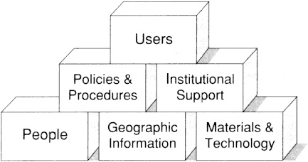
Figure 1. NSDI building blocks.
PREVIOUS REPORTS
Spatial Data Needs: The Future of the National Mapping Program
In 1990, the MSC issued a report entitled Spatial Data Needs: The Future of the National Mapping Program.3 The report resulted from numerous written reports and briefings provided by the U.S. Geological Survey (USGS). The vision of a cartographic enterprise and its sequel, the NSDI was developed, and recommendations pertaining to the National Mapping Division (NMD) of the USGS were provided. One of the most important recommendations made in the report is that the future role of the NMD should focus on coordination of certain NSDI functions in addition to production of spatial data. With the establishment of the Federal Geographic Data Committee (FGDC) by the Office of Management and Budget (OMB) to address coordination and standards objectives, NMD will be able to focus on supporting the operational aspects of NSDI development. In keeping with the recommendations, this current report addresses one aspect of the NSDI—the concept of federal/state partnerships to achieve production objectives.
Toward a Coordinated Spatial Data Infrastructure for the Nation
After assimilating information from 12 federal agencies, the MSC produced a report entitled Toward a Coordinated Spatial Data Infrastructure for the Nation.2 This report defined the elements of the NSDI and provided a conceptual framework for an enhanced spatial data infrastructure for the nation. The recommendations of that report follow:
-
Effective national policies, strategies and organizational structures need to be established at the federal level for the integration of national spatial data collection, use, and distribution.
-
The Federal Geographic Data Committee (FGDC), which operates under the aegis of the Office of Management and Budget (OMB), should continue to be the working body of the agencies to coordinate the interagency program as defined in
-
OMB Circular A-16. However, strengthening the charter is needed to:
-
expand the development and speed the creation and implementation of standards (content, quality, performance and exchange), procedures, and specifications for spatially-referenced digital data; and
-
create a series of incentives, particularly among federal agencies, that would maximize the sharing of spatial data and minimize the redundancy of spatial data collection.
-
Procedures should be established to foster ready access to information describing spatial data available within government and the private sector through existing networks, thereby providing on-line access by the public in the form of directories and catalogs.
-
A spatial data sharing program should be established to enrich national spatial data coverage, minimize redundant data collection at all levels, and create new opportunities for the use of spatial data throughout the nation. Specific funding and responsibilities of federal agencies should be identified by OMB, and the FGDC should coordinate the across-agency aspects of the program.
In keeping with this last recommendation, this present report expands the ideas of cooperation and partnerships between federal and state spatial data activities within the NSDI.
DISCUSSION
The NSDI is in existence today. It continues to evolve as the FGDC continues to define its role and responsibility for the nation's geographic data of the future. The Departments of Interior, Agriculture, Commerce, and Defense have been traditionally the major suppliers of spatial data. Most other departments and independent agencies are users, and sometimes suppliers, of spatial data. At the state level, over two-thirds of the states have active geographic information councils, geographic information sys
tems (GIS) coordination groups, or similar organizations responsible for coordinating spatial data; data collection activities are dispersed among the various agencies within a state. At the local level, most counties, municipalities, and utility companies are pursuing the collection and use of spatial data to address their information needs for management and planning.
There seemed to be a lack of coherent direction for the NSDI in the past, and the infrastructure often appeared chaotic. At all levels of spatial data handling, organizations are confronted by myriad problems, confusing policies, and even disincentives to coordinate their activities. Many of these problems are addressed in the previous reports of the MSC. The FGDC has made significant advancements in the past two years by effective communications of the NSDI challenge through newsletters, magazines, and professional journals. The FGDC has hosted conference forums and opened communications with state geographic information councils. This activity has served to heighten the awareness of NSDI and the need for broad-scale coordination to meet NSDI objectives. The metadata and spatial data transfer standards developed over the past few years are examples of the standards framework needed to enhance the NSDI. Without them, the ability to bring diverse data sets together would be severely impaired.
The federal government agencies and states will play an important part in building the data sets that go into the NSDI. Through standards development, the data structures have been minimally defined at least. The data framework needed to support NSDI will be addressed in a companion report The National Spatial Data Infrastructure: The Foundation Data, which is in preparation. This report promotes a concept that partnerships are valid means to develop these data sets and are essential to achieve longer-term NSDI objectives.
A comprehensive partnership program no doubt will have its inherent problems, but it will provide the opportunity to build the NSDI rapidly. With this in mind, the body of this report develops the partnership concepts. It begins with a discussion of the costs associated with the NSDI and how these costs could be minimized through partnerships. Then, the critical success factors for a federal/state partnership model for spatial data are presented; the same factors would apply to partnership models between any organizations. Partnership initiatives are being promoted currently as a valid approach to develop the information infrastructure. A review of relevant literature (Appendix A) clearly reveals this trend as well as the inherent challenges to make it all work. The factors were derived from
several data sharing programs currently in existence (Appendix B). Impediments to this model and roles of the various organizations in such partnerships are also discussed. The report concludes with a number of recommendations to further develop these spatial data partnerships.


