
6—
Geography's Contributions to Decision Making
Geography's long-standing concern with the evolving spatial organization and material character of the Earth's surface is of great relevance to decision makers in business and government. Whether the issue at hand is the location of a new public facility or the development of a stream restoration project, decision makers must consider such geographic matters as location, the relationship between processes at different scales, and the changing character of particular environments and landscapes. As such, geographic expertise can be of great importance in helping organizations and individuals operate more efficiently and make better-informed decisions.
Geographers contribute to policy and decision making in a variety of ways (Wilbanks, 1985). One contribution is through the publication of research findings in professional journals and other open-literature outlets. These insights usually influence decisions indirectly. Scholarly publications tend to influence society's general "climate of understanding" about issues, and society's opinions are transmitted to decision makers through a variety of channels (Weiss, 1977). Although most geographers believe that published research is more valuable before decisions are made, it is often more visibly used in justifying decisions made on other grounds, at least in public policy making (Wilbanks and Lee, 1985). One area of contribution in geography, incidentally, has been in understanding how geographic circumstances fundamentally influence decisions made by public policy makers (e.g., Clark, 1985; Murphy, 1989; Wolch and Dear, 1993).
A second kind of contribution is through reports produced for specific users. Particular problems and questions are posed—usually involving the application
of available knowledge rather than advances at the frontiers—and the answers are delivered on a schedule within a predetermined budget, in situations where the timing of a contribution is crucial to its impact. Most of these reports become a part of what has been called a "fugitive literature," seldom peer reviewed (though often intensely scrutinized) or cited in computer-accessible bibliographic databases, but directly impacting public and private decision makers. Although such professional work is usually associated with consulting firms and other nonacademic institutions, it is also a staple of "soft money" research centers in universities. Many leading geographers have been influential in this way, without always being identified explicitly as geographers.
A third contribution, and often the most powerful, is when geographers become a part of the decision making process, interacting on a personal, confidential basis with decision makers, drawing on a combination of formal knowledge, professional judgments, and mutual trust and effective communication. These roles are seldom reported in the published literature; in fact, the contribution often depends on maintaining confidentiality and letting others take the credit, with satisfaction derived from seeing the right kinds of policy decisions made. Many geographers, from Gilbert White and Edward Ackerman to William Garrison, John Borchert, Harold Mayer, and Brian Berry, have shaped policy in this way, but many of their accomplishments are not reported in the literature.
The problem for this chapter is reporting how geography contributes to decisions when the most powerful impacts are often the least documented—and the least documentable. Given the constraints inherent in the complicated relationship between science and government on the one hand and academia and business on the other, the committee has tried to emphasize subjects rather than specific impacts, offering a mix of evidence based mainly on the open literature but also referring in some cases to personal contributions that extend beyond formal publications. The committee has also tried to highlight issues where it believes geographers should be contributing to well-informed decisions but, for a variety of reasons, are not now contributing in significant ways.
The next section of this chapter discusses the various decision making "arenas" in which geographers work. The following sections illustrate geography's contributions at several scales: regional and local, national, and international.
Arenas for Decisions
Geographers and geographic perspectives have found important application in decision making in both the private and the public sectors. Geographers serve the public sector in many different roles, as government employees, consultants, private citizens, and volunteers for public advisory boards at levels from local to international. Private sector companies frequently use geographers and geographic knowledge to make location, routing, and marketing decisions and for
the management and analysis of spatial information in support of business decisions and communications at a variety of scales, from local to international.
The role of geographers in private sector decision making is growing rapidly, with improved technologies for decentralized geographic information systems (GISs) use and increased access to georeferenced information, and these roles are becoming strategic as well as operational. A wide range of private companies use geographers and geographic perspectives in their locational decision making. These include retail marketing chains (e.g., Dayton-Hudson, a major retail firm headquartered in Minneapolis), railroads (e.g., Southern Pacific Railroad's land division), electric power and gas utilities, international import-export firms, transportation and travel service organizations, publishing firms, and real estate planners and investors.
Regional and Local Decisions
Cattle ranchers in Brazil hire bulldozers to clear tropical rainforest for cattle ranching; farmers in Kenya build terraces to fight soil erosion on sloping cropland. The first set of decisions leads to environmental degradation, the second to environmental conservation. Steel mills close in the mature industrial regions of the developed world; semiconductor production moves to the newly industrializing countries of Malaysia and Thailand; high-technology firms spring up along the M4 Corridor west of Central London and in Silicon Glen near Glasgow, Scotland; major centers of retail and office activity known as "edge cities" spring up where major highway intersections occur beyond the suburbs of the 1970s, while blocks of apartments and townhouse communities locate close to subway systems, such as the Metro in Washington, D.C. The outcomes of these regional and local decisions affect the well-being of people, alter the look of the land, and set up new geographic patterns that affect the next set of location decisions that people make.
At local and regional scales, geographers assist decision makers by providing information and analyses related to such issues as the management of hazards, management of complex urban systems, and resource allocation, often wrestling with their overlapping roles as scientists and citizens. In addition, geographers advise local and regional government agencies about the design of geographic databases and the use of GISs. The following sections illustrate a range of contributions.
Urban Policy
Cities themselves are functional regions connected with other places by networks of transportation, communication, finance, and trade. Their internal structures can be distinguished according to such characteristics as race and ethnicity, housing, business activities, industrial processes, natural resource con-
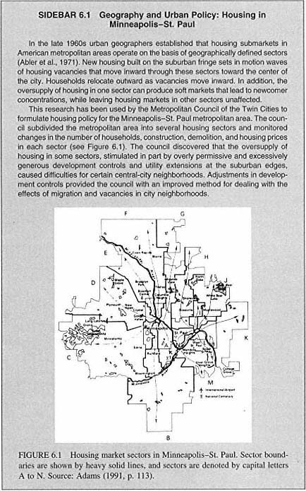
sumption, and pollution potential. The urban ghetto, for example, is at once the result of social, political, economic, and geographic processes, and addressing any one or two of these processes alone will not suffice to improve living conditions (Rose, 1971). Effective urban policy making requires an understanding of these spatial and functional characteristics, which are strongly geographic in nature (e.g., see Sidebar 6.1).
Metropolitan areas consisting of constellations of cities pose special problems and opportunities for policy makers owing to their political, industrial, and social complexities. The Los Angeles metropolitan area, for example, has evolved into industrial agglomerations based in part on high-technology firms that specialize in production for military applications (Scott, 1993). With the recent declines in defense spending, regional policy makers have worked to decrease the region's reliance on this sector of industry. Based on geographic analysis of the region's economic structure and role in the world economy, the Los Angeles County Metropolitan Transportation Authority and other agencies are developing an advanced ground transportation industry to take advantage of the region's skilled labor force and manufacturing capabilities.
Cities, of course, are more than built environments. People are their primary components, and significant inequities exist among city dwellers with respect to the basic necessities of life. Urban policies for the homeless, for example, show sharply defined geographic components (Dear and Wolch, 1987). Social and economic polarization, cyclical unemployment, changed housing and investment policies, and government policies for deinstitutionalizing the mentally ill have contributed to the increase in homelessness. Tolerance for the homeless tends to decline as distance from the city center increases. Policy makers and volunteers often reinforce the geography of the problem by concentrating their efforts to reduce homelessness on the central city. The policy implication is that homelessness, although rooted in the fabric of general society, has become a "city problem," and it is in the city that it will have to be resolved.
Water Resources
This nation's water resources are managed through massive public investments. By controlling the supply and distribution of water, reducing flooding, and offering recreational opportunities, the United States has created a partly artificial and partly natural hydrologic system that supports economic development, raising the quality of life for many but also decreasing the quality of life for others.
The diversion of water from rivers for irrigation, industrial uses, and urban water supply reshapes the character and geographic distribution of water-dependent ecosystems, sometimes eliminating them altogether. Overdrafts of groundwater supplies have lowered the water table in many areas, particularly in the western states, further altering surface ecosystems dependent on shallow groundwater.
Commonly accepted perspectives on the competition for use of public resources, such as Garrett Hardin's ''tragedy of the commons" (Hardin, 1968), view water resource allocation issues in terms of economics. An equally valuable perspective is geographic: water resource management problems are problems of geographic distribution. Consumers of water are concentrated in urban areas or in regions of fertile soil, whereas the water sources to sustain them are dispersed. New York City, for example, maintains an elaborate system of reservoirs and water treatment plants that extends more than 600 miles from the city. The Colorado River supports 20 million people, most of whom live far from the river in southern California, eastern Colorado, northern New Mexico, and central Arizona. Geographers contribute to the successful management of such far-flung systems by bringing their geographic perspectives to bear on the analysis of regional impacts of water resource decisions (e.g., see Sidebar 6.2).
The various sectors of American society are unequal consumers of water. In 1990, 48 percent of the total withdrawals from surface and groundwater supplies went to thermoelectric power generation, 34 percent to irrigated agriculture, and 7 percent to industry. Only 10 percent of all withdrawals went to the public water supply—the consumers who are bombarded by conservation messages when shortages occur (Sloggett and Dickason, 1986). Any national strategies for water conservation will have unequal consequences for various sectors and parts of the country, as well as locally and regionally.
In water resource management those who benefit are not necessarily those who pay. The federal government subsidizes western agriculture through irrigation development and eastern industry through flood control. In the generation of hydroelectric power, populations close to the river that generates the power, or populations who use the river, sometimes pay significant opportunity costs in terms of alternative uses they must forgo so the river can generate the electricity that benefits distant consumers. The geographic distribution of who benefits and who pays offers insights to decision makers who must balance competing social demands with a limited resource.
Geographers contribute to successful water management by providing data and analyses to help policy makers reach sound policy decisions. For example, geographer Edward Fernald established the Florida Resources and Environmental Analysis Center to collect and disseminate information to help solve statewide problems. The center has prepared state reference atlases, including the Water Resources Atlas of Florida. It also maintains data on flood-prone areas, inventories the uses of state-owned lands, and assists state and local areas in applying GIS techniques. California geographers have also produced a water atlas (Kahrl, 1979).
Retail Marketing
The old adage about the three most important factors in retail success—location, location, and location—still rings true. Location, of course, can refer
|
SIDEBAR 6.2 Geography and Management of the Colorado River in the Grand Canyon The flow of the Colorado River in Grand Canyon National Park is controlled by releases of water from Glen Canyon Dam, a structure governed by a set of policies known as the ''Law of the River." This collection of laws and operating rules specifies that the dam will be operated to deliver particular amounts of water downstream, generate electrical power, store water upstream, and trap sediment. In Grand Canyon National Park, which is located downstream from the dam, these operating rules have resulted in unacceptable erosion of riverside beaches, destruction of habitat for endangered fish, and creation of hazardous conditions for recreational users of the river. Research by Schmidt (1990), Bauer and Schmidt (1993), and other geographers showed how sediments in the river were being exchanged between beaches and deep pools in the river. Under flow conditions that had occurred naturally before the dam was closed, floods occasionally scoured the pools and built the beaches. Researchers determined that the dam could be operated to occasionally stimulate such flows. They further estimated that some sand still entered the Grand Canyon from undammed tributaries and that there was still enough water flowing through the canyon to distribute this sediment. After extensive congressional hearings, including testimony by Schmidt and other investigators, Congress passed the Grand Canyon Protection Act of 1992. This act directed the U.S. Bureau of Reclamation to operate the dam in a manner that protected downstream resources, including beaches and habitats they supported. The Bureau of Reclamation operated the dam experimentally for a year to determine the outcomes of various policies. In March 1996 the bureau released from the dam a modest flood flow of 45,000 cubic feet per second for a week. The flow scoured sand from the floors of pools in the canyon and deposited it on reformed beaches and bars, mimicking natural floods that were common before closure of the dam. The beaches and bars restored lost habitat for vegetation and fish and stabilized campsites for the 20,000 river runners who use the canyon each year. The success of the experimental artificial flood suggests that it will become a once-in-every-five-years feature of the dam's operation in a continuing effort to partially restore the physical, biological, and chemical integrity of the Grand Canyon ecosystem. |
to positioning in terms of price, service, and submarket, as well as to geographic location at national, local, and site-specific scales (see Figure 6.2). As retailing has become ever more competitive, optimizing the location of retail outlets has received increased attention from private sector decision makers.
Locating retail and other consumer-oriented facilities is fundamentally a geographic problem, a problem that has been addressed by geographers in both theory and practice. During the 1960s, geographer David Huff adapted spatial interaction models for use in retail location decision making (Huff, 1963). His models have been widely used by retail planners to estimate probabilities of patronage based on the attractiveness (e.g., size, selection, price) of an outlet
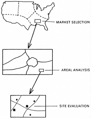
Figure 6.2 The success of a retail outlet depends to a large degree on its geographic location at national, regional, and local scales. All three scales must be considered in locational decision making.
Source: Ghosh and McLafferty (1987).
and its location relative to possible markets and existing competitors. These models depict individual behavior as probabilistic, and they depict trade areas as overlapping and competitive rather than discrete and monopolistic (Haynes and Fotheringham, 1984). The models also have great flexibility, allowing the analyst to set the number of locations or criteria such as maximum distance to consumers or maximum capital costs.
Location-allocation models allow decision makers to optimize the location of all kinds of consumer-oriented facilities, public and private: stores, shopping centers, health care facilities, and schools. As retailing has become increasingly dominated by chains, the use of these models has become commonplace (Ghosh and McLafferty, 1987).
Dispute Resolution in the Courts
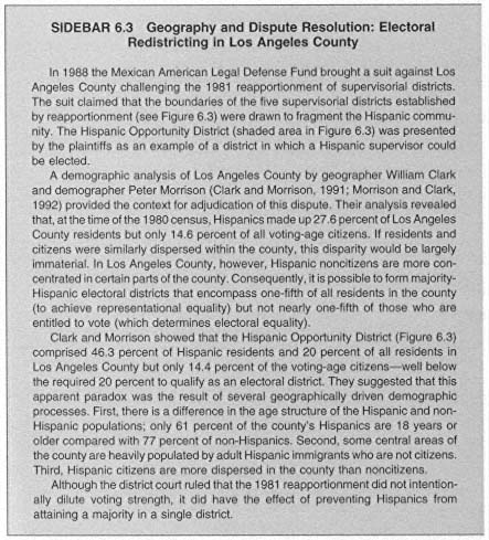
If it is true that geographic perspectives are important in developing policies, it is also true that such perspectives are important in defending or challenging such policies in court. Geographers frequently serve as expert witnesses in court cases where the legality of policies is tested. They have addressed residential segregation in cities for the U.S. Commission on Civil Rights; dealt with federal land management and environmental damage on Indian reservations in Indian Claims Court; devised busing plans for integration of school systems; and examined the human implications of physical processes such as accelerated erosion, river channel changes, flooding, coastal change, and lake dynamics in a variety of courts and administrative law proceedings (e.g., see Sidebar 6.3).
As expert witnesses, geographers engage in three types of activities. First, they provide a context for dispute resolution by defining the geographic characteristics of the area in dispute, the area's functional characteristics, and the systems that operate within it. Second, they testify about disputed facts. In cases dealing with housing discrimination, for example, the alleged discrimination must be defined accurately, demonstrated statistically, and mapped precisely. Third, geographers are frequently asked to apportion responsibility in court cases by defining what outcomes resulted from the actions of the defendant and what are likely normal outcomes on the social or environmental system. Accelerated erosion on valuable agricultural lands, for example, may be a product of negligent land management but also a product of entirely natural processes.
National Decisions
Geographers participate in national-scale decisions by illuminating the dynamics of regions and the flows of materials, information, and people. A particularly strong field of contribution has been in transportation systems and policy. In addition, geographers help society understand its physical environment, contributing to our understanding of environmental impacts and resource use. At this scale, in both public and private organizations, the contributions of geographers are often cloaked by confidentiality and proprietary rights. The following sections illustrate some key contributions.
Energy Policy
A vivid example of the application of geography's perspectives and tools in national policy making comes from the energy "crises" of the 1970s. In 1979 the U.S. Department of Energy was developing a plan to allocate scarce gasoline in the event of an oil import disruption, and the states were urgently concerned about equitable treatment. David Greene, a geographer at Oak Ridge National Laboratory, developed an analytical model for understanding the determinants
 |
of gasoline use for highway transportation. His analysis was the first to recognize differences between the states in terms of per-person or per-household consumption of gasoline, based on such factors as differences in population distributions and associated differences in trip length for the journey to work, shopping, and social interactions. During negotiations with the states, the model was used successfully by the White House to resolve issues of equity.
In this same period an analytical modeling system, conceived in large part by geographer T.R. Lakshmanan, was one of the nation's major tools for forecasting the environmental consequences of different energy policy options. The model was useful because it addressed such highly geographic questions as the possible effects of coal development in the western United States on emissions from smokestacks in the east.
 |
Economic Restructuring and Competitiveness
Discussions of economic policies at a national scale often follow one of two related lines: concerns about a nation's standing with respect to other nations in terms of productivity, per capita income, or broader measures of living standards, or concerns about economic trends within the nation. Both of these concerns are integral to national economic "competitiveness," defined as the ability to combine rising living standards with increasing flows of trade and investment.
Many geographers have argued that viewing competitiveness in terms of national interest and national-scale policy making is overly narrow and can lead to bad decisions. They have instead tended to focus on the interplay of global and local processes. For example, one concern has been with the impact of public
and private multinational institutions on local economies, especially local conflicts over labor issues that are related to adverse effects of a global competition in wage rates. A recent study by geographer David Angel for the U.S. Department of Commerce, for instance, has shown that alliances between multinational institutions and local groups are often associated with innovativeness and that such alliances strengthen local economic performance and benefit local economies (Angel, 1994).
Geographers generally consider competitiveness in terms of nation-or region-specific characteristics developed in response to place-specific economic histories. Economic development practice in many regions is moving away from pursuing large manufacturing facilities toward the redeployment of local assets, including a recognition of the potential of some service activities to foster economic growth, even in rural areas. This redeployment requires careful assessment of place-specific labor skills, product markets, technologies, and capital base, and an assessment of current and potential interactions with other regions or nations. Policy measures to improve competitiveness should be similarly place specific. In addition to the blunt tools of tax abatements or other subsidies, such policy measures can include targeted worker training, improved communications linkages, and arrangements for technical assistance (Glasmeier and Howland, 1995).
In these senses and others, geographers are involved by emphasizing the persistence of place distinctiveness and its effects on economic transformation. Much of the current research on industrial structure and place distinctiveness involves a great deal of labor-intensive personal observation, an extension of geography's tradition of fieldwork.
Technological Hazards
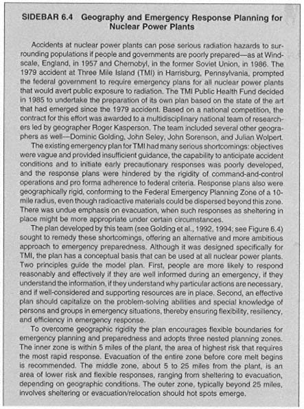
Building on a tradition of research on risks associated with natural hazards such as floods and droughts, geographers contribute both in theory and in practice to risk assessment for technological hazards. Many technological hazards, such as toxic waste disposal, chemical and nuclear accidents, and advanced weapons proliferation, are quite place specific. Consequently, evaluating the risk to human populations from such hazards calls for geographic perspectives (e.g., see Sidebar 6.4). Geographers have pioneered the development of risk assessment methodologies, hazard taxonomies, and hazard theories, and they have developed new understandings of how different groups perceive risk.
The solutions to many technological hazard problems are also strongly geographic. Over the past two decades, Congress passed an average of 23 laws per session dealing with technological hazards (Cutter, 1993), but many of these laws treat the nation monolithically and do not consider the "place matters" axiom of geography. Understanding and solving problems such as toxic waste disposal and high-level radioactive waste disposal call for the use of geography's core concepts (see Chapter 3): diffusion and dispersion; definitions of regions;
and spatial flows, past, present, and future (see Sidebar 6.5). For instance, airborne releases of contaminants from manufacturing facilities and from atmospheric tests of weapons are defined largely by the physical processes of atmospheric motion, but the health risks are related to the demographic characteristics of the
 |
 |
population in those regions. Risk assessment of air releases therefore must account for human and physical geography in an integrated regional analysis.
An important aspect of the safe disposal of high-level nuclear waste is the design of safe transportation systems to connect waste generators with disposal sites. The problem is to choose the route that will expose the fewest people to risk while at the same time minimizing travel time and maximizing efficiency. Designing a transportation network that balances these competing considerations draws on the experience gained from solving similar problems associated with delivering other public services. Geographers are centrally involved in designing and operating such systems for radioactive and other hazardous waste transport in the United States.
National Floodplain Policy
The Great Flood of 1993 on the Missouri and Mississippi River systems resulted in more than $10 billion in property losses (see Sidebar 6.6). Recognizing the importance of wise investment of reconstruction funds and the need for adequate understanding of floodplain processes in the affected areas, President Clinton created the White House Interagency Floodplain Management Task Force
|
SIDEBAR 6.6 Mississippi Floods: How Big Is BIG? Over a period of two decades, James C. Knox and his students at the University of Wisconsin, Madison, have investigated the physical evidence of changes in the regional river systems of the Upper Mississippi River system. Using sedimentological evidence, they have pieced together a comprehensive history of large flood events on the Upper Mississippi over the past 25,000 years. They used deposits of sediment left by these large floods to determine the depths of flow and then applied a standard engineering program model to calculate the likely amount of water in the various events. The results of their work show that between 25,000 and 14,000 years ago the Laurentide Ice Sheet controlled the flow of water into the system, causing major aggradation by sand and gravel. By about 14,000 years ago, the ice sheet began to melt and retreat, creating numerous proglacial lakes dammed behind moraines. Discharges from these lakes, whether of low magnitudes on a regular basis or of occasional high magnitudes in catastrophic releases, were sediment poor and highly erosive, resulting in the net removal of the previously accumulated sediment. The largest outbreak flood, the Lake Agassiz flood, occurred sometime before 10,800 years ago and had a peak discharge of about 30,000 cubic meters per second. In the time period between that mega-flood and the present, changes have been less radical. During the period between the Lake Agassiz flood and the present, very large floods have occurred, many of them of a magnitude similar to the great flood of 1993 on the Missouri and Mississippi River systems. When viewed on this long time scale, the 1993 flood does not appear to be particularly unusual. Without suggesting that human actions have had no effect on rainfall runoff and flooding, the policy implications of this finding are that (1) floods of the magnitude of the 1993 event should be expected to occur from time to time, and river managers should account for such events even with major flood control works in place; (2) floodplain areas are likely to be inundated despite the major levee systems now in place; (3) events of the magnitude of the 1993 event have occurred previously without the present human-induced changes in the system, such as altered land use on the uplands and draining of lowland riparian wetlands. Knox (1993) concludes that very large historical floods appear to be a result more of climatic factors than of land use. Perhaps regional residents are better off learning to live with the river and its floods rather than investing huge amounts of public capital in attempts to control a process that is climatically driven. |
to make recommendations to the federal government for floodplain recovery and management. The task force is chaired by Brigadier General Gerald E. Galloway, a geographer at the U.S. Military Academy.
Data for the task force's work was prepared by the Scientific Assessment and Strategy Team (SAST). The team, which was directed by geographer John Kelmelis, spent several months at the Sioux Falls, South Dakota, data center of the U.S. Geological Survey (USGS) creating a database of useful information for the task force. The database included information on hydrology, geology, landforms, soils, structures (levees, dams, dikes), land use, hazardous and toxic
materials, threatened and endangered species, and wetlands. Data were organized and presented as products from a geographic information system, which is capable of analyzing associations among the various types of data and provides the ability to map in detail individual reaches of the river system and adjacent environments (see Plate 10).
The work of this task force continues a tradition of contributions by geographers to federal management of flood problems. Previous reports by Edward A. Ackerman for the President's Water Resources Policy Commission (1950) and by Gilbert White for the Bureau of the Budget Task Force on Federal Flood Control (1966) have strongly influenced national floodplain management policies over the past five decades.
National Information Infrastructure
Government and business requirements for digital spatial data have stimulated a major effort to develop a national spatial data infrastructure (NSDI) along with associated spatial data transfer standards (see Chapter 5) and a national geospatial data clearinghouse (e.g., NRC, 1993b). Spatial data are useful in a wide variety of commercial applications ranging from marketing to navigation. Such applications require a publicly accessible spatial data infrastructure, digital cartographic databases, and global positioning systems (GPSs). Spatial data and associated geographic information analysis methods are also emerging as an integral part of national health policy discussions because many managed health care programs serve populations of geographically defined areas (e.g., Lasker et al., 1995).
Development of the NSDI has resulted in the creation of national georeferenced databases containing information about individuals. Such databases have fueled explosive growth in applications such as political canvassing, advertising, and travel. Geographers are contributing to the development of databases that allow easy access to such information. They are also engaged in research to assess who should have access to the data, how such access will affect the distribution of information and power in society, and what new legal and ethical principles will be necessary to control abuse in this rapidly developing area (Pickles, 1995a).
Creation of the NSDI is central to providing spatial data to the nation. In April 1994 President Clinton signed an executive order supporting the NSDI. The project will be directed by the Federal Geographic Data Committee through the Cartographic Requirements, Coordinating and Standards Program of the USGS. The NSDI will lead to the establishment of a geospatial data clearing-house—a distributed network of geospatial data producers, managers, and users linked electronically. The clearinghouse will publicize data availability, facilitate links between data suppliers and users, and ultimately provide direct access to data.
Geographers are also involved in several other research initiatives that will contribute to the NSDI, including the following:
- The National Center for Geographic Information and Analysis leads research into the fundamental design and operations of GISs, as well as related efforts (e.g., the Alexandria Project) to develop methodologies and tools for the creation of a digital spatial ''library." This library will allow decision makers, researchers, and the general public to easily access georeferenced information through the Internet.
- The U.S. Environmental Protection Agency's (EPA) Environmental Monitoring and Assessment Program (EMAP) monitors ecosystem changes at various spatial scales. The hierarchical database structure developed for EMAP now serves as a basis for much of EPA's environmental monitoring and analysis activities.
- The USGS's National Digital Cartographic Database supports the production of paper and electronic maps (see Sidebar 6.7).
- The U.S. Bureau of the Census has developed the Topologically Integrated Geographical Encoding and Referencing (TIGER) database (see Chapter 4).
- The U.S. Department of Energy's Environmental Spatial Analysis Tool (ESAT) project evaluates waste management alternatives.
- The National Center for Health Statistics has developed a cancer atlas.
- The U.S. Department of Transportation's Bureau of Transportation Statistics has undertaken a project to compile, analyze, and distribute data about the nation's transportation system.
|
SIDEBAR 6.7 Geography and the NSDI: USGS Geographic and Spatial Systems Program In addition to playing a major role in developing standards for digital geographic and cartographic data and coordinating the NSDI project, USGS researchers have been exploring ways to integrate and apply spatial data in policy and management contexts. The USGS's Geographic and Spatial Systems Program "supports research to develop and test new and innovative theories and techniques to manage spatial data, including research in new techniques for modeling, analyzing, and visualizing spatial data in GIS and in automated cartography, image processing, and land characterization" (Kelmelis et al., 1993, p. 36). This research underpins national policies dealing with human-environmental interactions. A significant component of these policies involves land surface characterization. As part of a research program directed toward integrating GIS technology, remote sensing technology, and environmental simulation models, a new 159-class dataset of land surface characteristics has been constructed for the conterminous United States (see Plate 11). The digital representation of this dataset is used in the land process components of general atmospheric circulation, watershed, hydrologic, ecosystem, and biogeochemical cycle models. |
Geographers participating in the above efforts design and develop data structures, methods for data manipulation and display, and tools for interactive geographic information analysis and visual display.
One of the greatest obstacles confronting research and development efforts, now and in the foreseeable future, is a dearth of people educated in spatial analysis, visualization techniques, and applications. Collecting and storing data are only part of the process; understanding and communicating its significance also are required. Thus, the development of the NSDI to support policy making challenges not only our technological expertise but also our education system.
International Decisions
The variability and connectivity of places are paramount for understanding the modern phenomenon of "globalization," be it the international economy or environmental change. This realization has pushed geographic approaches and geographers to the forefront of many emerging global issues with both science and policy relevance. In this role, geographers are engaged in several interdisciplinary and integrative collaborations that bridge the natural and social sciences. This is particularly true in the efforts by geographers in the International Council of Scientific Unions to marshall scientific expertise in studies of the environment and global change, as noted in the examples below.
Responding to Global Environmental Change
From Stockholm 1972 to UNCED-Rio 1992, the international community has been acutely concerned about changes being imposed by humankind on the biosphere and the consequences of these changes for such important issues as sustainable development, biodiversity, and climate change. Both researchers and policy makers understand that such changes are anchored in human-environment relationships, are created by complex human activities, and have important consequences that vary significantly by locale (see Sidebar 6.8).
If the world becomes warmer, for example, some areas will be drier while others will be cooler and wetter (Henderson-Sellers, 1995). Where such changes take place matters, particularly in regard to the local economies and abilities of societies to adjust. Most assessments concur that agriculture in the tropical areas of the world may suffer the most from warming, exacerbating already serious food problems. In contrast, agricultural impacts in the developed world, while important for individual farmers and local areas, are embedded in systems that provide far more latitude for adjustments (Parry, 1990; Appendini and Liverman, 1994).
Geography remains central in setting the agenda for scientific research to address the complexity and integrativeness of human and social behavior related to global environmental change. Geographers have helped to launch international
|
SIDEBAR 6.8 Geography and Adaptation to Climatic Change in Major River Basins One of the concerns associated with potential global environmental change is that less developed countries will be hardest hit because they will be least able to adapt. The latest assessment of global warming by the National Research Council Panel on Policy Implications of Greenhouse Warming (NRC, 1992b) was relatively optimistic about the ability of the United States to cope with anticipated changes. However, the panel was concerned that the less developed regions of the world would have greater difficulty in adapting to change because of the cumulative effects of population growth, weak infrastructures, and migration. One attempt to address this issue was led by geographers William Reibsame, James Wescoat, Gary Gaile, and Richard Perritt, with support from the EPA. Their study, which is described in Strezepek and Smith (1979), involved more than 20 scientists and water resource managers who assessed the potential effects of possible adaptive responses to climate change in five of the world's major river basins in less developed countries: the Mekong, Zambezi, Uruguay, Indus, and Nile river basins. The researchers linked the environmental consequences of possible global warming to hydrology and social conditions in each basin by extracting regional climate change scenarios from atmospheric circulation models and feeding the results into regional simulations of basin hydrology and water resource management. Regional responses included changes in flooding, hydropower production, and other natural resources. Local water resource managers in the five basins were asked how they would cope with the suggested scenarios, so that the project defined a realistic potential range of adjustments that policy makers might consider. Many of the river basins were quite adaptable, although the specific adaptations were varied. Adjustments such as the construction of small hydroelectric plants (as opposed to large dams), with flexible irrigation practices for the Uruguay and Mekong river basins, and planned development of new dams on the Zambezi and Mekong rivers provided increased resilience to change. On the other hand, the single large reservoir serving the Nile basin could fail to meet Egypt's irrigation needs under several climate change scenarios, and the extremely complex irrigation systems of the Indus River basin, which already suffers from high water tables, salinization, and water distribution problems, could begin to return fewer benefits as climate changes. Although the project did not recommend specific policies, it did provide a reasonable framework for considering policy responses to possible changes in the near future. |
collaborative research on greenhouse gases and climate change through SCOPE (the Scientific Committee on Problems of the Environment; Bolin et al., 1986). They are active in the development of reports of the IPCC (the Intergovernmental Panel on Climate Change) and of research agendas for various international global change science programs, including the International Geosphere-Biosphere Programme (IGBP) and the International Human Dimensions of Global Environmental Change Programme (IHDP). Geographic approaches and analytical techniques are central to such IGBP and IHDP projects as Data and Information
Systems (Townshend, 1992) and Land-Use/Cover Change (Turner et al., 1995), and geographers are also deeply involved with the Global Change System for Analysis, Research and Training and the Inter-American Institute.
In addition, geographers associated with the U.S. Agency for International Development (USAID) have been active in applying geographic perspectives and tools (particularly GISs) to strategies for coping with the relocation of refugees and the routing of supplies to support them.
Some of this work should find application in business strategy development, as global market conditions shift in the direction of environmental sustainability. For products and services to be competitive in national and regional markets a generation from now, business strategists must address the realities of "greener" policies on a global basis. Anticipating these changes in all their geographic complexity is becoming an increasingly important aspect of corporate planning.
Global Economic and Political Restructuring
During the past decade, the international economic and political order has undergone a profound transition. Formerly monolithic entities such as the Soviet Union and the Warsaw Pact nations have splintered into a host of diverse economic and political entities. Relationships among economies have changed as manufacturing has moved to developing countries with lower labor costs. Trade barriers have fallen as states in some parts of the world have sought closer economic ties with one another. New transnational networks have emerged as individuals and corporations have forged links outside traditional state structures.
Understanding global economic and political transformations is a complex task that is not the province of any one discipline, but geography has an important role to play. Indeed, one of the principal catalysts for the recent rediscovery of geography was concern over the inability of many U.S. citizens even to identify where particular changes were taking place, much less understand how they might be altering the political, economic, and environmental character of the planet (see Chapter 1). Geographic work on global political and economic restructuring provides insights into problems faced by decision makers by elucidating both the changing spatial organization of human and environmental phenomena and the effects of global changes on specific places (e.g., Johnston et al., 1995), as well as the relationships between them. At a regional scale, studies by geographers have sensitized policy makers to the problems and prospects of regional integration initiatives in regions such as the Middle East and Pacific Asia (Drysdale and Blake, 1985; Murphy, 1995a). At the local scale, geographers have helped public and private decision makers recognize the importance of geographic context when addressing resource management issues (see Sidebars 6.9 and 6.10).
The relevance of geographic thinking for efforts to understand global economic and political restructuring can be illustrated by considering three contemporary transformations of great significance: the growing reliance on market mecha-
|
SIDEBAR 6.9 Geography and the Development of Agricultural Policy Societies throughout the world are struggling to develop efficient and effective approaches to the management of agricultural land. In many cases, small landholders are on the front lines of such struggles. Research has shown that the ability of small landholders to increase production and conserve natural resources depends on their knowledge base and the extent to which they are able to play a meaningful role in resource management decisions. Consequently, a growing number of resource management initiatives are focusing on the situation of small landholders. One important example is a project led by Gerald Karaska, in which geographers are working with development anthropologists, economists, and others to assist the Sri Lankan government in its efforts to develop a program to increase the efficiency of water use and improve the lot of small holders without unduly sacrificing agricultural production and environmental quality. The project is part of a USAID initiative, the Systems Approach to Regional Income and Sustainable Resource Assistance (SARSA), which seeks to assist governments around the world in efforts to improve resource use. The project is designed to increase the control of resource users in management decisions through partnerships based on formal agreements between the state and small landholders. Since its inception in 1993, geographers have played a leading role in the Sri Lankan project, and its structure bears the imprint of their perspectives. The watershed is the basic unit of analysis, and studies of spatial relationships between economic and environmental variables have been used to understand the complexities of water management issues. Moreover, intensive participatory interaction among resource users and state and local officials has been employed to develop site-specific resource management strategies. The project identifies subregions sharing particular human and environmental characteristics, and these are then used as the spatial frameworks within which planning decisions are made. The project has already produced striking results, with farmers' organizations agreeing to share the flow of water and change their land uses according to their locations within watersheds. These results are expected to lead to national policy changes as well as to new laws that give farmers long-term usufruct rights to land and forest improvements. Another example shows how geographers can link their academic interests in development with the "hands-on" development work of nongovernmental organizations (NGOs) to influence agricultural policies. Anthony Bebbington, formerly of the Overseas Development Institute and now of the International Institute for Environment and Development, bridged the academic-policy gap in Ecuador and associated Andean regions (Bebbington, 1994). Working with the Inter-American Foundation and the Fundac para el Desarrollo Agropecuario (FUNDAGRO) in Ecuador, Bebbington expanded the meaning of farming systems to include indigenous farm organizations and investigated their role within the larger environmental system and the regional political economy. Special attention was given to federations of campesino communities, NGOs, the modern church, and certain agencies of the state and how these entities were used by the campesino to negotiate relationships with the market and the state. Bebbington's ethnographic work showed how agrarian societies interact with the NGOs, and he demonstrated diverse ways in which households, communities, and organizations interact and respond to changing economic and environmental conditions. Bebbington's work, in association with FUNDAGRO, made NGOs rethink their relationship with various indigenous farmers, particularly the campesino federations. The success in working with these federations has fed into international and national agricultural research institutions in Ecuador and the Andes, stimulating policy that involves such federations in determining agrarian policy and the nature of Andean agriculture. Andean agricultural development now incorporates indigenous farmer organizations and grassroots NGOs. |
|
SIDEBAR 6.10 Thornthwaite and Agricultural Practice In addition to his seminal work on potential evapotranspiration and the climatic water-budget (Mather and Sanderson, 1996), C.W. Thornthwaite was a pioneer in applied climatology, especially in relation to commercial agriculture. In a 1956 article that highlighted the applications of operations research, Fortune magazine devoted nearly a page to Thornthwaite's achievements "down on the corporate farm." The story illustrated how he was able to organize the planting and harvesting of peas and later of other crops grown on some 50,000 acres controlled by Seabrook Farms. Thornthwaite's "harvest design" revolutionized the produce industry, making it possible to efficiently schedule the whole farm program from planting, to irrigation, to harvest of vegetables, without overlap of vegetables or glut of produce waiting in the factory yard at processing time. According to Fortune, it also eliminated night crews, stabilized the work force, and improved labor relations, from which Seabrook Farms realized a substantial savings. Thornthwaite's own account of this use of an operations research approach appeared in the Journal of the Operations Research Society of America in February 1953 (Thornthwaite, 1953). |
nisms, the rise of democratic movements in various parts of the world, and the changing nature of the world economy. In the first case, increased reliance on the market shifts the relative influence over capital flows and accumulation from the public sector to the private sector. Geographers studying this process have highlighted the integration of financial markets, and the corresponding accelerated speed of capital circulation, a process dubbed "the annihilation of space by time" by Harvey (1989). While places are able to mitigate the threat of capital mobility, at least for a time, taking advantage of economic niches and centers of power within the "space of flows" (Castells, 1989), this acceleration increases the economic uncertainty faced by all places and the complexity of the ways in which growth and decline in different places, and at different spatial scales, are interrelated (Thrift, 1989). As a consequence, the interests and economic prospects of distant regions are continually bound together in new ways (Erickson and Hayward, 1991), and there is increasing demand for transportation and communications services (Warf and Cox, 1993).
In the second case, studies of political changes such as democratization have focused heavily on social and economic arrangements in individual states. Yet as a recent report to the National Science Foundation (Murphy, 1995b) makes clear, a geographic perspective on democratization is vital because it relates such concerns to underlying territorial, spatial, and environmental circumstances. How does a country's position in relation to international political and economic arrangements affect the ability of nondemocratic regimes to resist democratization initiatives? What threats do subnational regional inequalities pose for democratic regimes? To what extent does environmental change affect the emergence and
sustenance of democratic regimes? Geographic work on questions such as these provides decision makers with information about developing trends and with ideas about the circumstances under which democratic institutions are likely to flourish (e.g., Central Intelligence Agency, 1995).
In the third case, two processes increasingly characterize the changing world economy and will continue to impact the world economy in the next century. The process of globalization describes the growing integration of various parts of the world into a global economy (Dicken, 1992). The process of urbanization describes the growing concentration of the world's populations in cities. Some large cities have become key hubs for the control and coordination of global finances and of the global economy itself (Dieleman and Hamnett, 1994).
The growth of world cities is not without problems (Sassen, 1991). It is often in these cities that there are large gulfs between rich and poor, a polarization of social status that is exacerbated by increasing migration between developing and developed societies (Fainstein et al., 1992). The flows of population within North America and to the United States from nearby less successful economies is similar to flows in other parts of the world economy. These flows are having and will continue to have powerful effects on the urban structure and infrastructure of large and small cities in the United States. Policy debates over closed and open door immigration policies are only one manifestation of local problems that are the outcome of international changes.
Often independently of the growth of these command and control centers there is a growing urbanization of the world population as a whole. In just a few decades the number of very large cities has increased fourfold and many of these new large cities are in Africa and South America, where the infrastructure still lags behind the needs of the local populations. Solutions to these seemingly unsolvable problems are at the heart of creating a stable twenty-first century.
Technology, Service, and Information Transfer
The spread of ideas from place to place is a focus of geography, and potentially one of its most direct applications is to international trade. Here, geography's contributions could include helping decision makers understand the local context for trade with international partners and the importance of long-term social, economic, and environmental sustainability within this local context. International technology transfer and trade from the United States depends fundamentally on responding to local realities in other countries, which calls for certain kinds of expertise that geographers are expected to possess. Generally, however, geography as a discipline has been a minor player in this arena, partly because it has too seldom connected its best scientific insights with business decision making at the international scale and partly because its experts are so few.
Geographers also transfer their perspectives and techniques to more local problems. When children in a rural school district, for example, are bused to
school, each child's journey is a regional interaction. Questions such as the optimal placement of schools or the location of attendance boundaries for an existing set of schools to minimize the cost of student movement are important. The location-allocation modeling methods discussed earlier in this chapter have been developed to solve such problems in the United States, and these spatial decision support systems are now routinely used to find the best locations for many social and economic infrastructure elements in other countries as well (see Sidebar 6.11).
Geographers contribute to information policy by applying their expertise on evolving communication networks used by business and government, which affect international strategy development and implementation. Most directly, of course, geography contributes by transferring its own information and tools such as GIS hardware and software. In some cases this involves development of hybrid GIS tools to take advantage of computers and software already in place at regional levels in developing countries (Yapa, 1989). In addition, geographers have played an increasingly important role in efforts to develop international standards for georeferenced spatial data. These contributions include leadership of a multiyear effort within the International Cartographic Association to develop scientific and technical characteristics by which any national or international spatial database transfer standard can be assessed (Moellering and Wortman, 1994; Moellering and Hogan, in press) and participation (as Project Leaders and Experts) in the International Standards Organization Technical Committee on Geographic Information/Geomatics (ISO/TC 211).
Hunger
In 1990 more than one fifth of the world's population suffered from micronutrient deficiencies and nutrient-depleting illnesses. More than 700 million people faced chronic undernutrition. Tens of millions were highly vulnerable to famine. Hundreds of millions of children suffered from below-normal growth. These statistics illustrate the many faces of hunger and inadequate diets relative to the kind and quantity of food required for growth, activity, and the maintenance of good health.
The attack on hunger is a multidisciplinary and highly fragmented effort to which geographers contribute in a variety of ways (Bebbington and Carney, 1990). In collaboration with researchers in other disciplines, geographers are working to help policy makers understand the structure and root causes of hunger. They have identified three distinctive hunger situations: regional food shortages in which there is not enough food available in bounded areas; household food poverty in which there may be sufficient food available in an area but some households do not have the means to obtain it; and individual food deprivation, in which there may be adequate food, but food may be withheld from individuals, their special nutritional needs may not be met, or illness may prevent proper absorption of their diet.
 |
Researchers recognize that these situations are linked as in a cascade, at the bottom of which are individuals who are hungry. In times of regional food shortages, a cascade of troubles plunge food-sufficient households into food poverty and adequately fed individuals into food deprivation (see Figure 6.7). This understanding has led to major improvements in the conceptual basis for famine early warning systems.
Geographers are also leading efforts by NGOs to alleviate global hunger. Geographers Robert Kates and Akin Mabogunje cochair the organization Overcoming Hunger in the 1990s, which has proposed four achievable goals for reducing hunger by the turn of the century: (1) eliminate deaths from famine, (2) end hunger in half of the poorest households, (3) cut malnutrition in half for mothers and small children, and (4) eradicate iodine and vitamin A deficiencies. These goals have become part of the mainstream global hunger agenda; they appear in the resolutions of the 159 nations participating in the 1992 International
 |
Conference on Nutrition and the 1993 World Bank Conference on Overcoming Global Hunger.
Summary and Conclusions
This chapter has illustrated a wide range of issues in which geographers contribute to decision making in both the public and the private sectors. The chapter has also illustrated areas of concern where geography is not now contributing in any significant way but could be given increased attention, resources, and access to policy makers. A common theme throughout much of this review is geography's role as a provider of distinctive perspectives, information, and technology for decisions. Geography provides a valuable way of thinking about human and environmental issues, a way of thinking that emphasizes connections in complex systems and the importance of locations and arrangements.
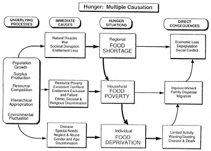
Figure 6.7
The causal structure of hunger.
Geography's contribution to decision making has a long and distinguished tradition starting with the founding of the United States. One of the earliest American geographies was Thomas Jefferson's Notes on the State of Virginia, a wide-ranging treatise dealing with a region extending from what are now the Middle Atlantic states into Ohio. Jefferson evaluated the development potential of the then-new United States through an analysis of its physical and human geography.
As the nation expanded westward, public- and private sector policy makers relied on the analyses of exploration geographers. For example, George Perkins Marsh's Man and Nature, Or, Physical Geography as Modified by Human Action led directly to the creation of new federal resource management agencies in the late nineteenth century. John Wesley Powell helped define national reclamation policy. Henry Gannett was a leader in defining the emerging national forest system. Harlan Barrows participated in numerous New Deal national planning boards for river basins. Carl Sauer worked with the Soil Conservation Service during the New Deal era to improve land management, and C.W. Thornthwaite worked with the U.S. Department of Agriculture on climatic classifications for assessing moisture availability for crops. Gilbert White profoundly impacted the nation's geographic perspective on floods and flood hazard management through his research and his service on prominent committees such as the Hoover Commis-
sion Task Force on Natural Resources to the Bureau of the Budget Task Force on Federal Flood Policy.
In recent years, geography and geographers have been less prominent in some aspects of significant national decision making. For instance, the Wilderness System and Wild and Scenic Rivers System were enacted essentially without geographic considerations. Potentially significant and wide-ranging contributions by geography to foreign policy have been hampered by the small size of the Office of the Geographer of the U.S. Department of State. Highly geographic problems—ranging from the designation of formal wine appellations in California to U.S. policy for deciding whether to intervene in regional or national conflicts outside the United States—are sometimes not addressed by geographers at all. When they are, geographers often do not interact with decision makers. In this respect the discipline has fallen short of its potential to make meaningful contributions to American society (e.g., Berry, 1994).
The limited ability of the discipline to respond to the geographic needs of decision makers is a result of at least two factors: a shortage of formal connections between geographers and decision makers and the small size of the discipline. Consequently, the United States lags behind the rest of the developed world in its geographic sophistication in many aspects of decision making. To borrow a Cold War expression, there is a ''geography gap" that may cost the nation dearly in terms of competitiveness and ability to achieve the twin goals of economic prosperity and environmental stability. Closing this gap depends on strengthening the foundations of the discipline along with its research and educational dimensions.


