
5
GROUND-WATER PATHWAYS TO THE COLORADO RIVER
Issue 3 The Potential for Hydrologic Connection Between the Site and the Colorado River
THE WILSHIRE GROUP POSITION
The Wilshire group's concern with a hydrologic connection between Ward Valley and the Colorado River arises from their concern that water may carry radionuclides from the waste down to the ground water. The Wilshire group identified a number of possible routes by which the ground water at Ward Valley could reach the Colorado River. As the water table beneath Ward Valley is 300 m higher in elevation than the Colorado Privet, the Wilshire group considers it possible that ground water flows from Ward Valley to other ground-water basins that discharge directly into the Colorado River. On the basis of interpretations of surface geology, subsurface materials, and data from wells and springs, they generalized these routes into five possible pathways (Figure 5.1). It is their opinion that ''the topography of the water table must be established before anyone can establish whether these pathways or others exist and estimates of ground-water flow rates must be established to evaluate any potential hazard to the Colorado River from contaminated ground water'' (Wilshire et al., 1994). They argued that additional data are needed before these routes could be eliminated as potential pathways.
In the absence of information on the elevation of the water table between the site and the Colorado River, the Wilshire group based their analyses on the identification of the major hydrogeologic units, estimation of the probable permeability characteristics of each unit, and the determination of the subsurface extent of each unit. They made use of gravity data to infer the subsurface distribution of their hydrogeologic units. They assumed that: (1) Quaternary and Tertiary alluvial sediments have a high permeability, (2) Tertiary volcanic rocks have somewhat lower and more variable permeability, but locally have significant fracture permeability, (3) gneiss and granite above the detachment fault system locally have significant fracture permeability, and (4) footwall rocks beneath the detachment surface are relatively impermeable.
The Wilshire group assessed the likelihood of these routes as follows (Wilshire et al., 1994):
Even if all bedrock is impermeable, ground-water routes south through Ward Valley and through low-density materials in low-relief divides to Rice (route 1) and Vidal Valleys (route 2) still are probable. If fractured high-density rocks above the detachment fault are permeable, routes east or southeast to Chemehuevi Valley and Piute Valley (routes 3 and 5)
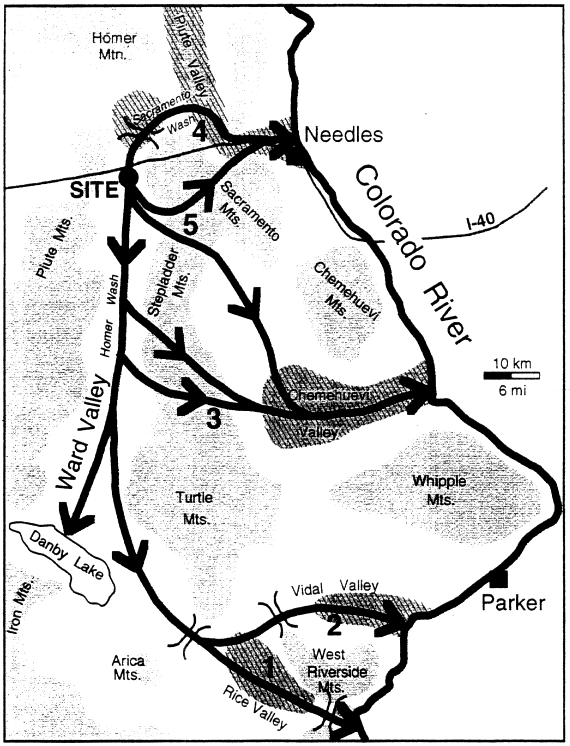
are viable. If drawdown by pumping takes place in basins up-gradient from the site, the hydrologic gradient could be reversed so ground water at the site could communicate with that leading to or under Piute Valley (route 4).
Details of Pathways
Details of the Wilshire group's viewpoints on each of these routes can be summarized as follows:
Route 1: Ground-water flow from Ward Valley may bypass Danby Dry Lake and enter Rice Valley (Figure 5.1). The entire route from the site to the Colorado River could be within basin-fill deposits. No bedrock projects high enough to interfere with a continuous slope of the water table from Ward Valley to the Colorado River. The only possible interference from bedrock is the divide between Rice Valley and the Colorado River. Because it has yet to be proven that a cone of depression in the water table encircles Danby Dry Lake, such a pathway is possible. Thus, they conclude that "Danby Lake (sic) may have much less discharge and less storage capacity than claimed in the site evaluation documents, and ground water may flow continuously from Ward Valley to the Colorado River."
Route 2: Route 2 is similar to route 1, except that it assumes that once the ground water enters Rice Valley, it passes through a divide between Rice and Vidal Valleys and then flows to the Colorado River. The Wilshire group argued that route 2 is possible because of the relatively great depth to crystalline rocks beneath the topographic divide between Rice and Vidal Valleys. Even if ground water flows above the crystalline rocks, it can be at a low enough level that a topographic divide would not impede ground-water transport.
Route 3: This route assumes pathways through low-density volcanic rock and fractured high-density rock within the mountains that. flank the east side of Ward Valley (between the Stepladder and Turtle Mountains). The ground water then enters the alluvium in Chemehuevi Valley. Ground water is observed in shallow wells in the Turtle Mountains. The Wilshire group stated that if these observations represent perched water, which is accumulated water held above the water table by layers of lower permeability in the unsaturated zone, there can still be a regional water table at a deeper level with a continuous slope from Ward Valley to the Colorado. If, however, the wells penetrate the regional water table rather than perched water, the topographic high on the water table, which the water levels denote, precludes existence of a pathway between Ward and Chemehuevi Valleys.
Routes 4 and 5: Both of these postulated routes pass beneath the Sacramento Mountains, through fractured rocks above the detachment zone. The depth to the detachment zone here is uncertain. Route 4 requires a reversal of the present-day hydraulic gradient beneath the site, which would result in the ground water flowing in a direction opposite the known slope and direction of flow of the ground water (presumably by ground-water withdrawals in Piute Valley). Route 5 is presented as two possibilities, one through fractured upper plate rocks connecting Ward and Piute Valleys, the other is inferred because of the occurrence of a northwest-striking fault that crosses between the Stepladder and Sacramento
Mountains. The Wilshire group noted that springs high on the north side of the Sacramento Mountains would have to represent small perched ground-water zones rather than the regional ground-water system if this route is to be viable because their pathway assumes ground-water flow at a much deeper level than that of the springs.
The Wilshire group concluded from these arguments that several potential paths for ground-water flow through basin fill or fractured bedrock exist and must be tested for a complete analysis (Wilshire et al., 1994). They noted that although ground-water travel times are hundreds to thousands of years for these routes, the long-lived radionuclides slated for disposal at Ward Valley will be dangerous for much longer periods of time. It is their opinion that a full analysis of these potential pathways is required and should involve additional geophysical exploration, drilling, water chemistry testing, and ground-water flow rate determinations.
THE DHS/U.S. ECOLOGY POSITION
According to the Department of Health Services, the postulated hydrologic connections between the local ground-water flow system in Ward Valley and the Colorado River are not credible. Furthermore, these connections are not relevant to an objective evaluation of the Ward Valley low-level radioactive waste disposal site (Brandt, 1994a). DHS argues that, given a very low probability that dissolved radionuclides in the alluvial aquifer under the disposal site will ever reach the Colorado River, and because such a release would lead to no discernable radiological impact on the Colorado River, there is no risk to the public or to the environment.
The DHS described the shallow ground-water flow system beneath Ward Valley as "a relatively undynamic flow system". This characterization is based on the apparent magnitude of the north-to-south hydraulic gradient (3.0 meters per kilometer reported by US Ecology in the license application), and the estimated age of the ground water beneath the site (>10,000 years, based on carbon-14 dating).
Although not stated explicitly in their October 7 document, the DHS appears to accept the interpretation of recharge and regional ground-water flow that was proposed by M. Bedinger in his presentation to our panel, and as outlined in his USGS report (Bedinger et al., 1989). Precipitation falling in the mountains surrounding Ward Valley above an elevation of 1200 meters recharges a regional bedrock ground-water flow system. Bedinger postulates that this bedrock flow system may discharge to the Colorado River. His calculations of ground-water travel time in this regional system through bedrock are on the order of a million years (Bedinger et al., 1989). The alluvial aquifer in Ward Valley is a local ground-water flow system, possibly with underflow from Lanfair Valley, mountain-from recharge in the upper reaches of alluvial fans on the east and west sides of Ward Valley, and infrequent, localized recharge along Homer Wash. Local ground-water flow in Ward Valley is generally north-to-south, with discharge by evaporation at Danby Dry Lake.
Route 1 and 2: The DHS has stated, based on its review of the license application, that little, if any, ground-water flows in the alluvial deposits from Ward Valley to Rice Valley. Any such flow would be insignificant were it to occur. It is their position that, although direct evidence is insufficient to demonstrate conclusively the presence, position, and elevation of a ground-water divide between Ward and Rice Valleys, multiple lines of indirect evidence support the interpretation of a shallow ground-water divide. For example, they noted that the Wilshire group's postulated alluvial aquifer connection between Ward and Rice Valleys is contradicted by differences in the chemical composition of the ground water in southern Ward Valley and Rice Valley.
The DHS believes that additional information on the local ground-water flow system in Ward Valley or the ground-water divide between Ward and Rice Valley is not needed for purposes of evaluating the performance of the disposal facility. The saturated zone is viewed as providing an unnecessary but redundant isolation capability to that provided by the unsaturated zone under the disposal site. In the DHS view, potential transport of small concentrations of dissolved radionuclides in the local ground-water system from the northern portion of Ward Valley over 68 km southward to discharge at Danby Dry Lake would be so slow that it would allow substantial time for decay of the radionuclides to stable forms and provide ample opportunity for further reduction in the concentration of any dissolved radionuclides by dilution, dispersion, sorption, or precipitation. The DHS argues that another approximately 68 km of subsurface flow through Rice or Vidal Valley, if it were possible, would only increase confidence that this potential pathway would not adversely impact public health and safety or the environment.
Routes 3 and 5: DHS maintains that potential pathways through the mountains southeast and east of the site to Chemehuevi Valley (route 3) and Sacramento Wash (route 5) are contradicted by available data. The mountains on the east and west sides of Ward Valley represent recharge areas and ground-water divides for the regional and local ground-water flow systems. They pointed out that the Wilshire group "must disclaim existing water level data in wells and mine shafts in the mountains in order to claim the potential for groundwater flow along these routes" (Brandt, 1994a).
Rome 4: Route 4 is considered to be not credible by DHS and their contractors because: (1) it requires ground-water flow into one side of a hypothetical cone of depression, and ground-water flow out of a different side of that cone of depression, (2) it ignores the 135 years of planned operational and post-closure environmental monitoring and institutional control, and (3) it ignores evidence of low well yields in the Ward Valley area, and the large pumping lifts that would be required to develop the ground-water resource that could lead to large enough ground-water withdrawals to reverse the flow direction.
THE COMMITTEE'S APPROACH
The Geological Framework for the Ground-Water Pathways
An evaluation of the issue of ground-water pathways involves consideration of the bedrock structure beneath the alluvium, and the hydraulic conductivities of the older (Tertiary) alluvium, and of the upper and lower plate rocks. The configuration of the bedrock surface and whether or not bedrock highs beneath the alluvium rise above the present water table bear directly on the validity of some of the postulated pathways to the Colorado River.
The tectonic setting of the proposed Ward Valley LLRW site has been described by Wilshire et al. (1994), and is summarized briefly in Chapter 2 of this report. An important structure of concern is a Cenozoic normal or low-angle detachment fault between an upper. plate of unmetamorphosed Mesozoic and Tertiary volcanic and sedimentary rocks, and a lower plate of metamorphosed older rocks. Partial answers to questions related to the nature and extent of interactions between the water table, the saturated zone, and bedrock materials and structures, and their bearing on the alternative ground-water pathways may be obtained using available geologic and geophysical data.
Subsurface Bedrock Topography
The series of geologic events outlined in Chapter 2 of this report reveals a scenario whereby a very irregular bedrock topography with considerable relief could exist throughout Ward Valley beneath the Quaternary alluvium (Figures 2.10 and 2.11). This irregular bedrock topography could influence the present-day ground-water regime.
Fracture Permeability
Bedrock types both upper and lower plate rocks, with the exception of the old alluvium in the vicinity of Ward Valley—generally have a low porosity and permeability. The rates of ground-water flow in the bedrock will depend to a large extent on the degree to which fractures enhance the permeability of these rock units. Even within zones of enhanced fracturing, field experience at other sites suggests that the permeability will be lower than that of the Quaternary alluvium. This is generally the case in most of the Basin and Range, except in areas underlain by carbonate rocks (Bedinger et al, 1989). Where bedrock highs intersect the surface of the water table, as possibly occurs in some of the topographic divides along the alternative pathways proposed by the Wilshire group, additional opportunities exist for interaction between the ground-water system in alluvium and bedrock. The degree to which bedrock highs may perturb, or restrict, potential ground-water pathways in the alluvium will depend upon the height to which they penetrate the alluvium and the degree to which fracturing enhances the permeability of the bedrock units.
Prior to the August meeting, several members of the committee accompanied Keith Howard to a locality where a major detachment fault is exposed in the southern Piute Mountains. This fault separates high grade metamorphic rocks (Precambrian basement) of the lower plate from unmetamorphosed Miocene(?) sandstone and conglomerate ("old" alluvium). All of the rocks near the fault are intensely fractured and the fractures are open. Most often such fractures are closed at depth, either by mineral filling or by the overburden pressure (Pollard and Aydin, 1988). It is not known if all fractures are closed at depth in bedrock, but the spacing and intensity clearly change as a function of proximity to faults.
A Hydrologic Evaluation of the Proposed Ground-Water Pathways
The hydrogeologic database is inadequate to determine whether or not any component of the ground water flowing beneath the Ward Valley site eventually reaches the Colorado River. In order to evaluate potential pathways, it would be necessary to know: (a) the elevations of the water table along the potential pathways to determine if a gradient is sufficient for flow, (b) the three-dimensional distribution of fluid potential in the vicinity of any ground-water divide, and (c) the hydraulic conductivity of the geologic materials along the proposed pathway to determine if those materials have sufficient permeability to allow significant amounts of water to be transmitted through them.
Water-Level Data
Water-level data at the regional scale are limited, both spatially and temporally (LA Appendix 2420.A). The paucity of wells, particularly of wells with more than one or two recorded water level measurements, does not permit the accurate determination of regional hydraulic gradients and flow directions. The best-supported hydraulic gradient, that through the Ward Valley alluvium, is based on water-level measurements in four monitoring wells. Many of the data for the older wells are from the first half of the century, are poorly documented, and are of unknown reliability.
Hydraulic Conductivity
Hydraulic conductivity determinations exist only for the alluvium beneath the proposed LLRW site, and those are of questionable quality. Because no observation wells were within the area of influence of the pumping wells during aquifer testing, all the pumping test analyses were interpreted as single well tests. Single well tests generally underestimate transmissivity because well losses produce excess drawdown over that which occurs in the porous medium surrounding the borehole. The range of values for hydraulic conductivity obtained with the single-well pumping tests is 0.02 to 0.7 m per day, with a geometric mean of 0.12 m per day (LA Section 2420.1.3.1). David Huntley, consultant to the Wilshire Group, estimated
hydraulic conductivities to be on the order of 1.2 to 12.2 m per day (Huntley, 1994). In their hydrogeologic review of the Ward Valley site prepared for the Metropolitan Water District of Southern California, GEOSCIENCES Support Services, Inc. used a range of 2 to 24 m per day in their calculations; this range was based on various types of data, including grain-size analyses, analyses of geophysical logs, and pumping test analyses from adjacent valleys (GEOSCIENCES Support Services, Inc., 1994).
It is also possible to estimate the hydraulic conductivity of the alluvial sediments in Ward Valley on the basis of a calculation using Darcy's law (Equation 3.1 in Chapter 3 of this report), and assuming that most of the ground water flowing through the valley discharges at Danby Dry Lake (see Box 5.1). On this basis, the committee estimated the hydraulic conductivity of the alluvial valley fill to range from 2.7 to 6.1 m per day. These values are an order of magnitude greater than the values used in the license application, are similar to those used by the Wilishire group, and are slightly less than the values estimated by GEOSCIENCES Support Services, Inc. The ground-water travel times to Danby Dry Lake, determined with our estimates of pore-water velocities, range from 850 to 1800 years (Box 5.1). These estimates can be compared with the age of the ground water beneath the Ward Valley site, estimated using 14C dates (See Chapter 3). They are consistent, in a general sense, if it is assumed that the ground water beneath the Ward Valley site originated from recharge areas at the northern end of Ward Valley or within Lanfair Valley.
Beyond the boundaries of the site, there are neither hydraulic conductivity measurements for the basin-fill alluvium within Ward Valley, nor information on the nature and variability of sediment type along the length of the valley that might serve to estimate hydraulic conductivity. However, the uplands forming the valley boundaries, from which the valley-fill sediments are derived, are similar along the entire length of the valley. Therefore, the physical characteristics of the valley-fill alluvial sediments are not expected to vary greatly over most of the valley length. The nature of the fracture permeability in the bedrock beneath and surrounding the site is unknown, particularly the extent of fracturing and the degree to which those fractures may have been healed by the deposition of minerals along their openings (See discussion in Chapter 3 on fracture permeability).
The majority of the ground-water flow beneath the site appears to go to Danby Dry Lake, based on limited hydrologic and geologic data and topographic conditions. The extensive efflorescent deposits indicating continuous, long-term evaporation from a shallow capillary fringe at Danby Dry Lake, the shallow level of the ground water (approximately 1.5 m below the playa surface), and the high salinity of the ground water attest to the fact that evaporation is occurring from the playa surface and that this is a major discharge area. If a large portion of the discharge were occurring elsewhere, it would be unlikely that the shallow water table would coincide with the playa.
It cannot be ruled out, however, with the presently available data, that some portion of the ground-water may be leaving the basin. While Ward Valley may be an enclosed surface-water basin, it is not necessarily enclosed with respect to ground water. Some combination of permeability and hydraulic gradient for a particular pathway could permit a fraction of the flow from the valley to exit towards the Colorado River. Such pathways could be either
|
Box 5.1 Estimated Hydraulic Conductivity and Travel Times for Ward Valley An estimate of the hydraulic conductivity of the alluvial sediments in Ward Valley can be made using Darcy's Law, a means of calculating the rate of movement of ground water, and assuming that most of the flow through the valley discharges at Danby Dry Lake. Estimates of discharge at the lake vary from 1.4 × 10⁷ m3/yr (11,000 acre-ft/yr) (Law/Crandall, 1992), based on a fraction of the pan evaporation and the area of salt-covered sediments, to 2.7 × 10⁷ m3/yr (22,000 acre-ft/yr) (LA Section 2420.1.2.2), based on potential evaporation rates and the surface area from which evaporation could occur. In the Law/Crandall calculation, an evaporation rate of 24 cm/yr was used, which is greater than published values in the recent literature. Allison and Barnes (1985) found an average evaporation rate from a dry lake to be 17 cm/yr, while Ullman (1985) determined 1 to 2 cm/yr for long-term evaporation rates from a salt-crust covered playa. If one considers the Law/Crandall estimate as a reasonable upper bound and takes into account that areas south and west of Danby Dry Lake, that are not part of Ward Valley, also contribute ground water to the discharge at Danby Dry Lake, a contribution of 1.1 × 10⁷ m3 /yr (9,000 acre-ft/year) is a reasonable upper bound on the discharge (Q) through Ward Valley. If the lower evaporation rates cited from the literature are more accurate, a value of 4.9 × 10⁶ m3/yr (4,000 acre-ft/yr) would be more reasonable. The hydraulic gradient (dh/dl) as measured from the Camino Well (ground-water elevation, 437 m above mean sea level (amsl)) to Danby Dry Lake (ground-water elevation, 184 m amsl) over a 68 km distance is 0.0037. An average saturated cross-sectional area for the valley was estimated to be 250 m thick and 5.6 km wide. The effective porosity (ne) for the partially cemented alluvial materials is assumed to be 0.10 (LA Section 2420.1.3.2; GEOSCIENCE Support Services, Inc., 1994; Huntley in Wilshire et al., 1994). Using Darcy's law (see Equation 3.1, after replacing q by Q/A and H by h for horizontal flow), the hydraulic conductivity (K) can be calculated: K = Q/ (A dh/dl) K = 4.9 × 10⁶ m3/yr / (250 m ×5600 m × 0.0037) = 946 m/yr = 2.6 m/d For a Ward Valley contribution to evaporation at Danby Dry Lake of 1.1 × 10⁷ m3/yr, the hydraulic conductivity would be calculated to be 5.8 m/d. Corresponding pore water velocities (vp) are: vp = (K/ne) (dh/dl) = 2.6 m/d / 0.10) (0.0037) = 9.6 × 10⁻² m/d = 35 m/yr for the lower discharge rate and 0.22 m/d (= 79 m/yr) for the higher discharge rate. Travel times from the proposed site to Danby Dry Lake over the 68 km distance (L) are: L / vp = 68,000 m / 35 m/yr = 1900 yr for the lower discharge rate and 860 yr for the higher discharge rate. |
through (a) continuous alluvial deposits through adjacent valleys, or (b) a combination of alluvial and bedrock pathways through the adjacent mountains and valleys, as described previously in this section.
The hydrogeology of Miocene extensional valleys of southeastern California and the Great Basin of Nevada and Utah is controlled in part by the permeability contrast between the alluvial valley-fill deposits and the bedrock. The other major hydrologic controls are the spatial and temporal distribution of recharge. Higher precipitation and often higher recharge rates associated with higher elevations of the mountains generally (but not always) create ground-water divides between adjacent valleys. These factors will determine whether the flow is restricted to a local basin flow system or if interbasin regional flow occurs. The license application presumes that the surrounding and underlying rocks are of relatively low permeability and that ground-water flow divides are associated with the topographic divides, thus creating an enclosed ground-water basin as well as an enclosed surface-water basin. Flow in the carbonate rock province of the Great Basin, which includes much of Utah and Nevada and extends into California to a point about 80 km north of the Ward Valley site, is characterized by interbasin movement of ground water through the permeable lower carbonate aquifer (Winograd and Thordarson, 1975). In locations such as Yucca and Frenchman Flats the ground water in the younger hydrogeologic units moves principally downward into the underlying lower carbonate aquifer. Elsewhere, such as in the southern Amargosa Desert and in southern Indian Springs Valley, the ground water in the younger sediment derives from upward leakage of water from the underlying lower carbonate aquifer. Permeability in this lower carbonate aquifer is not related to primary porosity, but to fracture permeability enhanced by dissolution. There is no carbonate bedrock between the Ward Valley sate and the Colorado River.
Winograd and Thordarson (1975) stated that, with reference to downward hydraulic gradients, "declining heads with increasing depths are attributed to at least three causes: (1) penetration of an unsaturated zone beneath a perched zone; (2) energy losses in areas of dominantly vertical movement, as is common in recharge areas or areas with semi-perched ground water; and (3) penetration of an aquifer of the same or greater transmissibility than the overlying aquifer but with a lower discharge point."
While the Ward Valley site is clearly outside of the carbonate aquifer province, a downward vertical hydraulic gradient is apparent between MW-01 and MW-02. It is greater than the horizontal hydraulic gradient by approximately a factor of three. The explanation for this apparent downward hydraulic gradient is unclear. One hypothesis (Harding Lawson Associates, 1994) is that more transmissive alluvial deposits exist deeper in the aquifer system and that such a depositional pattern would be expected in the valley. The permeameter determinations revealed lower hydraulic conductivities for a number of the deeper core samples (LA Sections 2420.2.1.2 and 2420.3.1), indicating that if the valley does contain alluvium with higher permeability, it must be below the current depth of investigation.
Another possible explanation for the apparent downward hydraulic gradient is the presence of a higher permeability zone in the fractured fault blocks beneath the site and along the surface of the detachment fault itself. If highly fractured fault blocks exist, they could have significant permeability, as could the detachment fault zone.
Still another possible explanation of the apparent vertical gradient is non-verticality of either or both wells involved, as mentioned in Chapter 3.
REVIEW OF PATHWAYS
All pathways postulated by the Wilshire group are predicated on the fact that the Colorado River (and immediately adjacent ground water) is approximately 300 m lower than the water table beneath the site. If no intervening water table highs or low permeability hydraulic barriers exist, which would create a ground-water flow divide, ground water could flow towards the lower elevation of the Colorado River.
Routes 1 and 2 (Rice Valley and Vidal Valley): These routes are possible because of an apparent continuity of permeable alluvial materials from Ward Valley through Rice and Vidal Valleys. Arguments that a ground-water divide exists beneath the topographic divide in the region leading to Rice Valley are not supported by any reliable water level data. Well-survey data (LA Figure 2420.A-4) indicate water levels in the area that are lower than the water levels at Danby Dry Lake, therefore indicating a hydraulic gradient that could drive flow towards Rice and Vidal Valleys. Because the water-level data date back three to eight decades, however, their reliability is uncertain. Although no information precludes a groundwater divide, its presence cannot be substantiated with the current data.
Arguments against a flowpath connecting Ward and Rice Valleys based on differing major ion chemistries draw upon observations in Thompson et al. (1987) which suggested sodium sulfate water in Rice Valley as opposed to sodium bicarbonate water in Ward Valley. The determination for Rice Valley is based on a single sampling point, and no sampling point is indicated for Ward Valley in that work. This database is insufficient to allow us to draw reliable conclusions. Bedinger et al. (1989) indicated that both Ward Valley and Rice Valley contain primarily sodium bicarbonate water. Without further corroboration, the geochemical argument is not defensible.
The fraction of flow from Ward Valley, if any, which discharges into Rice and Vidal Valleys as opposed to evaporating at Danby Dry Lake, is unknown and, therefore, cannot be categorically considered insignificant, as was done by DHS. However, long travel times, on the order of thousands of years, and long travel distances to the Colorado should minimize adverse effects of potential releases from the proposed site.
Route 3 (Stepladder Mountains to Chemehuevi Valley) and Route 5 (Sacramento Mountains): These possible pathways would pass through volcanic or crystalline upper-plate rocks. If these rocks contain open fractures, they could be locally permeable, although their permeability is thought to be less than that of the alluvium in Ward Valley. No hydraulic conductivity data exist for these rocks, although partial healing of the fractures by the deposition of hydrothermal minerals could be expected to reduce the permeability.
Bedinger et al. (1989) estimated the relative ground-water velocities at the water table in the rocks to be 2 to 3 percent of the velocities in the alluvium (Plate 4 in Bedinger et al., 1989). They also modeled travel times through the volcanic rocks of the Turtle Mountains
and then through Chemehuevi Valley to the Colorado River to be on the order of tens of thousands to hundreds of thousands of years (Plate 6 in Bedinger et al., 1989).
High water levels have been noted in springs and wells within the mountains. These may reflect local perched ground-water systems or they may reflect the shallow regional water table. The presence of a shallow hydraulic gradient from the mountains westward towards Ward Valley, if such a gradient exists, does not eliminate the possibility of eastward flow in a deeper flow system. This is particularly true if the deeper flow system is partially isolated from the shallow system, such as could occur with a heavily fractured zone along the detachment fault.
Route 4 (Sacramento Wash to Piute Valley): The plausibility of this pathway is predicated on long-term, large-volume pumping of ground water in the Piute Valley. The pumping could presumably lower the water table over a sufficiently large area to reverse the hydraulic gradient at the site and cause the direction of ground-water flow to change from southward to northward. The likelihood of such pumping is unknown. The pathway would pass through upper plate rocks which would be permeable if fractured, although presumably less permeable than the alluvium. While not impossible, this potential pathway is speculative and unlikely, in the committee's judgement.
DHS argues that monitoring will continue for 135 years, and this should detect any such reversal of the hydraulic gradient. They do not address what would happen if such a reversal were to occur after that time period. They also argue that the path requires flow into one side of the pumping cone of depression and out the other side, which is not plausible. Furthermore, in the committee's opinion, if high activities of radionuclides were detected in the hypothetical wells in Piute Valley, the wells would most likely be turned off and some kind of remedial action implemented.
Another potential impediment to ground water flow from beneath the site eastward to the Colorado River along the postulated pathways discussed in this section is influence of potential recharge from Homer Wash. If sufficient recharge occurs from this wash, the hydraulic effects may be sufficient to confine ground water in the valley fill west of the wash to the west side of the valley, thus preventing significant flow paths from crossing Homer Wash.
We would have a better understanding of the alternative regional pathways, gradients, ground-water flow rates, etc., if data from three drill holes to bedrock were available: (1) midway down Ward Valley; (2) on the Rice-Ward Valley topographic divide; and (3) on Route 3 through the Stepladder Mountains. In the judgement of the committee, however, it would not be possible under any reasonable scenario for site characterization to confirm, or eliminate with absolute certainty, the postulated regional bedrock pathways.
THE MAGNITUDE OF POTENTIAL IMPACTS OF LONG-LIVED RADIONUCLIDE MIGRATION FROM THE SITE TO THE COLORADO RIVER
Although k is the committee's view that most, if not all, of the Ward Valley ground water discharges at Danby Dry Lake and evaporates, a portion of the water could possibly bypass Danby Dry Lake through one or more of the four pathways the committee regards as possible to reach the Colorado River, Rice Valley (Route 1), Vidal Valley (Route 2), the Stepladder Mountains (Route 3), or the Sacramento Mountains (Route 5). To assess the relative Significance of these scenarios, one can make some bounding estimates of potential impacts on the water quality of the Colorado River using one of the pathways.
Assumptions for Bounding Estimates
To make such bounding assessments, some initial assumptions are needed regarding basic flow system characteristics, particularly the approximate path lengths and approximate travel times.
Path Length
Based on Figure 5.1 (from Wilshire et al., 1993) showing postulated pathways to the Colorado River, routes 1 and 2 are approximately 130 km long (through the Rice or Vidal Valleys). The other possible pathway is the Wilshire group's route 3 eastward beneath the hills at the south end of the Stepladder Mountains. The approximate length of that pathway is 80 km from the proposed site to the Colorado River.
Travel Time
As discussed in the previous section, sufficient information is available to allow reasonable estimates of ground-water travel times to be made with some confidence for the purpose of this analysis.
As indicated above, the gradient along the Ward Valley portion of routes 1 and 2 is estimated to be about 0.0037 m/m, based on water levels in the monitoring wells at the proposed site and the elevation of Danby Dry Lake. The overall change in hydraulic head to the Colorado River is about 360 m in 130 km for a gradient of 0.0028 m/m. Travel time can be estimated using the Darcy velocity equation (page 5-16), together with estimates of hydraulic conductivity, gradient and effective porosity. Assuming the total pathway gradient is 0.003 m/m and K = 5.8 m/d, vp = (5.8 × 0.003)/0.1 = 0.18 m/d or 67 m/yr. For K = 2.6 m/d, the velocity is 0.078 m/d or 28 m/yr. Total travel time along routes 1 or 2 of 130 km would then be about 1,900 years, for K = 5.8 m/d and 4,600 years for K = 2.6 m/yr. These are adequate times for the decay of short-lived fission and activation-product radionuclides
present in low-level waste; however, they are not sufficient times for the decay of long-lived alpha-emitting transuranics such as plutonium-239 to decay (half life = 24,100 years). This travel time analysis assumes that the plutonium reaches the water table immediately upon emplacement in the facility and allows no time for water and dissolved radionuclides to migrate vertically downward from the site through the unsaturated zone to the aquifer. As discussed in Chapter 3, it is expected that the residence time of any radionuclide migrating through the unsaturated zone will be at least on the order of hundreds of years.
Thus, for the purpose of this bounding assessment, it becomes important only to examine the potential impacts of waste components having half-lives longer than a few hundred years.
Potential Impacts on the Colorado River
Potential Radioactive Contamination by Ground Water
Plutonium is one of the longer-lived components of low-level waste that can be examined. DHS estimates that the total plutonium inventory of all the waste received by the site over its 30-year operational history will be from ''a fraction of a curie to 2 curies from decontamination waste, and a fraction of one cure to several curies from other sources'' (Brandt, 1994b). Radionuclide composition of the waste is certified by the generators and will be monitored by the DHS and the site operator. DHS has enforcement authority over radionuclide quantity restrictions.
As discussed in Chapter 1, based on the report from the Congressional Research Service (Holt, 1994) and the letters from the US NRC (1994a, b) addressing the controversy over the amount of 239Pu expected among the wastes, the committee applied the lower order of magnitude agreed upon by both agencies for the estimate. If we assume that "several" plus two curies means approximately 10 curies, then a potential bounding impact can be computed.
For a conservative estimate, we can assume a scenario in which the entire 10 curies of plutonium is released into the underling aquifer over a period of 30 years (the same rate at which it enters the repository). This release scenario is not credible in the Committee's opinion, but it can serve to introduce a degree of conservatism for this calculation. We further assume that the plutonium is released in a chemical form that is some sort of stable organic complex, (such as a chelated form, like ethyldiamine tetra-acetic acid (EDTA), a commonly used chelating agent that is present in part of the waste). Chelated plutonium is not subject to solubility constraints nor any retardation reactions, such as adsorption, which adds further conservative assumptions. In other words, it migrates along the ground-water flow pathway at the same speed as the ground-water pore velocity and is therefore not subject to any significant decrease of concentration through retardation and radioactive decay. This assumption, like the first, is also not credible in our judgement, but nonetheless can be useful in developing a conservative calculation.
Under this scenario, one thirtieth of the assumed 10 curies (Ci) plutonium inventory, or 0.33 curies per year (Ci/yr), would enter the Colorado River each year for 30 years, once it
traversed the path length. According to the Metropolitan Water District (Fisher, 1992), the average flow of the Colorado River below Needles is about 10 billion m3/yr (8 million acre-feet per year). In the future this flow is likely to decline significantly as the up-river states divert more of their full legally appropriated shares. Therefore, in this analysis we assume the average flow to be 5 billion m3/yr (4 million acre-feet per year), which is about the flow rate required to satisfy down-stream legal allocations. If 0.33 Ci of plutonium entered a river flow of 4 million acre-feet per year, the resulting concentration would be 0.07 pCi/1 (4 million acre ft = 4.9 × 10¹² liters and 1 Ci = 1012 pCi). According to the Metropolitan Water District (MWD), (Fisher, 1992) the average present concentration of natural alpha-emitting isotopes in Colorado River water is about 4.4 pCi/l, based on recent river flow rates which are much higher than the future flow rate assumed for the above plutonium calculation. Therefore, an addition of 0.07 pCi/l would be insignificant, in the committee's judgement, especially when compared to the MWD's health-based regulatory standard for gross alpha-emitting radionuclides of 15 pCi/l (which excludes the natural isotopes of uranium, 226Ra, and 222Ra ). In other words, the river is currently transporting 44 Ci per year of natural alpha-emitting isotopes. The addition of 0.33 Ci per year is small compared to the annual natural load of 44 Ci per year.
A few other long-lived alpha emitting radionuclides may also be present in some of the waste (i.e., Uranium-238 and Americium-234) but in estimated quantities much lower than plutonium. The foregoing analysis for plutonium would therefore be applicable and relevant also for those other long-lived isotopes.
It is also important to note that this hypothetical discharge of 0.33 Ci/yr from the site to the Colorado River would require a combination of circumstances that has an incredibly low probability of occurring. This calculation is presented, therefore, only to show that actual potential impacts, if any, would be much less than the result calculated here. The committee based the calculation on an assumed waste plutonium inventory of 10 Ci. Even if the released plutonium quantity were 100 times greater than assumed here (103or 1000 curies), the maximum hypothetical impact on the Colorado River concentrations would be 7 pCi/l, which approaches but still remains less than the health-based regulatory criterion of 15 pCi/l. Implicit in this worst-case scenario is the assumption of instantaneous transport of radionuclides from the disposal site to the water table, giving no credit for retardation or adsorption in the unsaturated zone. If, however, future analysis indicates that significantly greater amounts of plutonium will be disposed in the facility, more detailed modeling incorporating the transport processes affecting the concentration of plutonium would have to be performed.
Factors Affecting Radionuclide Transport
Some of the key factors that would greatly diminish potential impacts of long-lived isotopes on the Colorado River are the following:
-
Because much of the Ward Valley ground water likely discharges at Danby Dry Lake, it is not credible for the entire quantity of any isotopes released from the site into the aquifer to follow a minority pathway (if it exists) to the river.
-
It is unlikely that plutonium or any other transuranic isotopes could remain in a highly soluble and unretarded chemical form for the entire duration of the migration to the river. The most mobile and frequently employed complexes of plutonium are organic chelates, which tend to be unstable and degradable over long periods of time (Means and Alexander, 1980). Therefore, significant retardation would ultimately cause great delays in plutonium migration and concurrent decay.
-
No credible mechanism has been identified that could dissolve and leach out all the plutonium (or any other isotope) from the site over a period of a few decades and carry it to the aquifer. Therefore, releases, if any, to the aquifer would be much lower than assumed.
-
Even if the plutonium were released over a few decades, dispersion processes over the long pathways would spread the plume out over a long period of time and dilute it to an extent that any potential impacts on the Colorado River would be significantly diminished below that calculated herein.
Conclusion Concerning Contamination of the Colorado River
Although the committee considers that there are conceivable, but unlikely, flow paths for some of the Ward Valley ground water to the Colorado River, we conclude that the potential impacts on the river water quality would be insignificant relative to present natural levels in the river and to accepted regulatory health standards.
Potential Radioactive Contamination by Airborne Dust
Another potential scenario that has been postulated for impacting the Colorado River or the water in the Colorado River Aqueduct is by airborne transport of radioactive dust from Danby Dry Lake. Under this scenario, plutonium would be leached out of the site into the aquifer, and carded to Danby Dry Lake where it would be deposited as an evaporite precipitate into the sediment as the ground water evaporated. It would then be picked up by wind and carded eastward to the Colorado River.
If we again allow all of the assumed 10 Ci plutonium inventory to be released over 30 years (0.33 Ci/yr), it will be deposited into the Danby Dry Lake bed at the same rate some time later (again assuming no retardation or dispersion). Although the Law/Crandall (1992) study of Ward Valley concluded that evaporation at Danby Dry Lake occurs over an area of 75 km2, we assume, for conservative purposes, that the major evaporation area is only 21 km2 based on information presented by J.P. Calzia (1992). If the plutonium is deposited over this area in the upper inch of soil, it would amount to 0.33 Ci per 19 × 10 6 ft3 of soil per year, which is about 0.33 Ci per 4 × 10⁹ kg, or about 0.08 pCi/g. Only a small fraction of that soil could be transported away from Danby Dry Lake by wind each year, but even if it all were
transported, only a small fraction could fall out specifically into the Colorado River or the Colorado River Aqueduct, which occupy relatively small areas. In this case a combination of circumstances with an extremely low probability would have to occur Oust as in the previous scenarios) to cause any substantial portion of the long-lived isotopes to become deposited in the Danby Dry Lake sediments. Therefore, the committee concludes that the potential impact of airborne radionuclides on the water quality of the Colorado River or Colorado River Aqueduct is minuscule, even much less than the upper bounding calculation made previously for the direct ground-water pathway scenario to the river.
SUMMARY OF CONCLUSIONS
The committee concludes that:
-
Based on limited hydrologic and geologic data and the topographic conditions, the majority of the ground-water flow beneath the proposed site in Ward Valley appears to discharge at Danby Dry Lake. It cannot be ruled out, however, that some portion of the ground water passing beneath the proposed site may leave the Ward Valley basin.
-
It would not be possible under any reasonable expectation for site characterization either to confirm, or to eliminate with absolute certainty, any of the regional bedrock pathways that have been postulated by the Wilshire group.
-
While there are conceivable, but unlikely, flowpaths for some ground water within Ward Valley to reach the Colorado River, conservative bounding calculations suggest that the potential impacts on the river water quality would be insignificant relative to present natural levels of radionuclides in the river and would meet accepted regulatory health standards.
-
The committee concludes that the potential impact of airborne radionuclides on the water quality in the Colorado River or Colorado River Aqueduct is minuscule, much less than the upper bounding calculation for the direct ground-water pathway scenario to the river.
REFERENCES
Bedinger, M. S., Sargent, K. A., Langer, W. H. 1989. Studies of the geology and hydrology of the Basin and Range province, southwestern United States, for isolation of high-level radioactive waste - characterization of the Sonoran region, California. U.S. Geological Survey Professional Paper 1370-E, 30 p.
Brandt, E. C. 1994a. Summary of the California Department of Health Services presentation to the Committee to Review Specific Scientific and Technical Issues Related to the Siting of a Proposed Low Level Radioactive Waste Disposal Facility in Ward Valley, California. October 6, 1994.
Brandt, E.C. 1994b. Letter to I. Alterman, September 22.
Calzia, J.P. 1992. Geology and saline resources of Danby Lake Playa, southeastern California. Pp. 87-91 in Old Routes to the Colorado, Reynolds, R. E., compiler. San Bernardino County Museum Association Special Publication 92-2.
Fisher, S.M. 1992. The Metropolitan Water District of Southern California Annual Report for the Fiscal Year July 1, 1991 to June 30, 1992.
GEOSCIENCES Support Services, Inc. August 1994. Hydrogeologic review of the proposed Ward Valley Low-Level Radioactive Waste Facility, prepared for the Metropolitan Water District of Southern California.
Harding Lawson Associates. 1994. Summary of well installation, water-level monitoring, and aquifer testing, Ward Valley, California: Unpublished Report. October 6.
Holt, M. 1994. Plutonium Disposal Estimates for the Southwestern Low-Level Radioactive Waste Disposal Compact. Memorandum dated June 3. Congressional Research Service. Library of Congress. Washington,
Huntley, D. 1994. Directions and rates of groundwater flow, Ward Valley, in Ward Valley proposed low-level radioactive waste site: A report to the National Academy of Sciences. Wilshire, H. G., K. A. Howard, and D. M. Miller, eds.
Law/Crandall, Inc. 1992. Water resources evaluation, Ward Valley, San Bernardino County, California, prepared for City of Needles.
License Application. 1989. U.S. Ecology, Inc. Administrative Record, Ward Valley Low-Level Radioactive Waste Disposal Facility, Section 2420, and Appendix 2420.
Means, J. L. and C. A. Alexander. 1980. Final report on the environmental geochemistry of chelating agents and radionuclides complexes, BMI-X-701, Battelle Columbus Laboratories.
Pollard, D. D. and A. Aydin. 1988. Progress in understanding jointing over the past century. Geological Society of America Bulletin. 100:1181-1204.
Thompson, T. H., J. A. Nuter, W. R. Moyle, and L. R. Wolfenden. 1987. Maps showing distribution of dissolved solids and dominant chemical type in ground water, Basin and Range province, southern California. U.S. Geological Survey Water Resources Investigation Report WRI-83-4116C.
U.S. Nuclear Regulatory Commission. 1994a. Letter from M. R. Knapp to Ina Alterman, National Research Council. Dated November 23.
——— 1994b. Letter from M.R. Knapp to Ina Alterman, National Research Council. Dated December 14.
Wilshire, H. G., K. A. Howard, and D. M. Miller. 1993. Description of earth-science concerns regarding the Ward Valley low-level radioactive waste site plan and evaluation.
Wilshire, H. G., K. A. Howard, and D. M. Miller. 1994. Ward Valley proposed low-level radioactive waste site: a report to the National Academy of Sciences.
Winograd, I. J., and W. Thordarson. 1975. Hydrogeologic and hydrochemical framework, south-central Great Basin, Nevada-California, with special reference to the Nevada Test Site, U.S. Geological Survey Professional Paper 712-C.


