
6
SUBSURFACE MONITORING PROGRAM
Issue 4 Adequacy of Plans to Monitor Ward Valley Ground Water and Unsaturated Zone
THE WILSHIRE GROUP POSITION
The specific issues raised by the Wilshire group were the lack of plans for post-closure monitoring of the unsaturated zone or the ground water downgradient from the site and the absence of remediation plans if unacceptable levels of radionuclides are detected off site. In their first memorandum, based on the draft EIR/S, the Wilshire group asserted that no plans were in place for post-closure monitoring (Wilshire et al., 1993a). Subsequently, upon reading more recent licensing documents, they questioned the adequacy of the plans that were in place (Wilshire et al., 1993b).
THE DHS/U.S. ECOLOGY POSITION
The DHS and U.S. Ecology pointed to the detailed plans to conduct monitoring of the unsaturated zone and the ground water during the operation of the facility (<30 yrs). These plans are described in a later section in this chapter. DHS/USE stated that once the disposal operations are completed, U.S. Ecology will conduct post-closure environmental monitoring for 5 years. This period of post-closure monitoring can be extended until DHS determines that the closure requirements have been met. The institutional control period (<100 yr) must include an environmental monitoring program according to 10 CFR Part 61 to provide early warning of radionuclide release.
Two basic types of monitoring are proposed for Ward Valley: (1) regulatory compliance monitoring to assure that contaminant releases do not exceed regulatory levels at the disposal system boundaries and (2) performance monitoring to provide an early warning of releases that may exceed regulatory levels. The compliance boundaries are the air, vegetation, and water table at the edge of the buffer zone. Monitoring in the unsaturated zone constitutes performance monitoring because the unsaturated zone is not a regulatory compliance boundary. Performance monitoring of the unsaturated zone is critical because this is the primary barrier to radionuclide migration. The data provided by the proposed unsaturated-zone monitoring program will be critical in evaluating the performance of the ward Valley facility and will be compared with the results of performance assessment models of the site.
THE COMMITTEE'S APPROACH
Recognizing the importance of the unsaturated-zone monitoring, the committee emphasizes in this section performance monitoring that will be conducted to determine if the site is performing as expected.
THE PERFORMANCE MONITORING PLAN FOR THE UNSATURATED ZONE
Emphasis has generally been placed on performance assessment modeling to demonstrate the performance of near-surface waste disposal facilities. Such modeling is used to evaluate the long-term performance of engineered barriers and the natural system. Lack of field data to verify and validate the computer models, however, would limit certainty in model predictions and confidence in simulation results. As very few sites have been studied that can be considered analogs to the proposed engineered barrier system at Ward Valley, our understanding of how these systems perform is limited.
The committee also notes that the Ward Valley monitoring program does not specifically address the monitoring program relative to performance assessment during operation, closure, and post-closure site evaluations.
Scope and Purpose of a Monitoring Plan
Monitoring is defined in 10 CFR Part 61 as "observing and taking measurements to provide data to evaluate the performance and characteristics of the disposal site" (U.S. Code of Federal Regulations, 1982). This general definition of monitoring suggests that site characterization should be an integral part of a monitoring program and is an ongoing activity that continues during operation and the extended period of institutional control of the site. Although traditionally site characterization, monitoring, and performance assessment have each been conducted independently, various agencies involved in waste disposal such as the Nuclear Regulatory Commission (NRC) and the Department of Energy (DOE) increasingly recognize that site characterization, monitoring, and performance assessment should be integrated (Campbell et al, 1993).
Although fundamental site characterization data are collected prior to license application, it is the committee's judgment that site characterization should be continued through the operational phase (U.S. Code of Federal Regulations, 1982). Continued site characterization data collection and monitoring through operations will provide an understanding of long-term processes. Monitoring ambient conditions distant from the engineered facility will provide background data and act as a control for comparison with monitoring data from the engineered facility. An additional reason for continuing site characterization studies is that, as our conceptual understanding evolves of how arid systems behave and our ability to measure and monitor hydraulic parameters improves, the resulting reliable data will reduce uncertainties and increase confidence that the site will perform
effectively in isolating the waste. Site characteristics are critical to waste disposal in arid settings because reliance is ultimately placed on the natural system to contain the waste. The site characterization and monitoring data collected during operation should be used for the performance assessment analysis required prior to closure. A continuing performance assessment can be used to guide site characterization and monitoring by determining what the critical data are and also by defining the optimal sampling locations and frequency. In the opinion of the committee, integration of site characterization, monitoring, and performance assessment can be regarded as an iterative process with feedback from each component.
Scope of Ward Valley Proposed Monitoring Plan
The applicant's proposed monitoring program outlined by U.S. Ecology (1991) does not include the integrated approach discussed above and is limited to monitoring only. The applicant plans to update the performance assessment if the monitoring results do not agree with the performance assessment (U.S. Ecology, 1991, Figure IV.b.a). The applicant's monitoring program includes up to 30 yr of operational monitoring, 1 yr of closure monitoring, 3 to 5 yr of post-closure monitoring and 100 yr of institutional monitoring.
PERFORMANCE MONITORING OF THE UNSATURATED ZONE
The original unsaturated-zone monitoring plan in the license application was subsequently enhanced on the basis of recommendations from a select committee on this subject. Thirteen objectives for the proposed monitoring program were outlined and included the following:
-
provide early detection of significant contaminants;
-
monitor beneath, adjacent to, and above the waste;
-
incorporate improved monitoring technology as it becomes available;
-
avoid compromising the integrity of the disposal system;
-
provide acceptable accuracy and reproducibility.
The monitoring systems for the A and B/C trenches are similar. A critical component of the monitoring program is the concept of monitoring islands (2.4 to 3 m diameter) (Figure 6.1). The islands will be placed at approximately 60 m intervals that correspond to incremental excavation of the trenches. Three islands will be placed in each cross section: one in the center of the trench and two in the margins of the trench. Instrumentation similar to that installed in the islands will be installed in the undisturbed sediments adjacent to the trench. The islands will consist of vertically stacked concrete culverts that will be constructed in advance of the surrounding waste and backfill (Figure 6.1). To minimize damage during
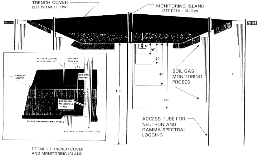
operations, 2.7 m3 bulk soil bags will be used. The caissons may be left open while the site is active to allow access to instrumentation and will be backfilled during facility closure. A trench-cap demonstration unit (TCDU) will be constructed outside the disposal facility as part of the monitoring program.
Monitoring the Trench Cover
The main objectives of monitoring the trench cover are:
-
identify and quantify releases of volatile radionuclides such as 3H ,14C, and radon (222Rn) to the atmosphere and vegetation;
-
quantify concentrations and concentration gradients of volatile radionuclides;
-
• evaluate the performance of the cover in minimizing infiltration.
To meet these objectives, the monitoring will consist of:
-
measurement of vertical water-vapor flux from the land surface using flux chamber, porometer, or other equivalent method;
-
measurement of plant transpiration using flux chamber, porometer, or other equivalent method;
-
vegetation sampling and analysis for 3H and 14C radionuclides;
-
soil-gas sampling at 1.5, 3.6, and 5 m semiannually and analysis of 3H, 14C, and 222Rn;
-
neutron logging to detect changes in water content and gamma-spectral logging to detect changes in radionuclide composition using access robes installed to 5 m on a regular schedule and within 24 hr of precipitation events >2.5 cm.
The monitoring system (Figure 6.1) will be restricted to the upper 6 m to avoid penetrating the compacted amended clay layer or capillary barrier. Trench-cover monitoring will be conducted primarily adjacent to the monitoring islands. In addition, measurements of surface flux, plant transpiration, and vegetation sampling will be conducted at one randomly selected location within four randomly selected 15 m2sampling grids for each 60 m section.
Monitoring Beneath the Trenches
Monitoring beneath the trench constitutes downgradient monitoring in terms of the unsaturated zone. The objectives of monitoring beneath the trenches are to monitor changes in water content, and radionuclides in the gas and liquid phases. Neutron and gamma-spectral logging will be conducted in vertical access robes installed to 30 m beneath the center of the bottom and sidewalls of each trench and also in slant access robes installed beneath the
sidewalls and base of each trench to a maximum depth of 3 m below the trench floor. These slant boreholes will be installed at one location between the monitoring islands. Soil-gas samples will be collected at depths of 1.5, 3, 6, 12, and 18 m beneath the base of the waste trenches in the center and sidewalls. Additional slant boreholes will be drilled to collect soil samples if other monitoring indicates significant migration of radionuclides.
Monitoring Adjacent to the Trenches
The proposed monitoring system adjacent to the trenches is similar to that within the trenches in evaluation of atmospheric releases of volatile radionuclides and quantification of concentrations and concentration gradients of volatile radionuclides in the trench-cover materials. In addition, soil-water balance of native sediments will be examined. The instrumentation used is similar to that installed in the trenches and penetrates to a maximum depth of 30 m below land surface. The culvert design is not required in this setting as the system does not penetrate the waste.
Trench-Cap Demonstration Unit
The Trench-Cap Demonstration Unit (TCDU) will be located outside the control area but within the fenced portion of the site. The dimensions of the TCDU will be approximately 46 m long and 30 m wide and 6 m deep. The TCDU will be divided into two segments to allow evaluation of both the A and B/C trench covers. Nonradioactive packages simulating the disposed waste will be emplaced in the TCDU. Instrumentation including neutron-probe access robes, heat-dissipation probes (HDPs) and thermocouple psychrometers (TCPs) will be installed in the thickest section of the cover and in the native soil along the interface between the cover and excavation sidewall. The HDPs will be installed in a small bag of silica flour that is prewetted to a matric potential slightly higher than that of the soil. TCPs will be installed in 2.5 cm PVC casings that are slotted at the depth that the TCP is to be placed. A 0.63 cm air line will extend from the TCP casing to the surface and will be used to purge the system. Neutron-probe access tubes will consist of 5 cm aluminum casing. The HDPs and TCPs will be connected to an integrated data acquisition system for automated monitoring at hourly or daily frequencies. Monitoring of neutron access tubes will be event based.
Committee Observations on Proposed Performance Monitoring of the Unsaturated Zone
-Major Issues-
The committee concludes that the foregoing description of the monitoring program demonstrates that there are detailed plans to conduct performance monitoring
during operation of the facility. Section 5300.1.1 of the license application states that the operational environmental monitoring program will continue ''in full force and effect'' for approximately 5 yr after closure of the facility; however, the environmental monitoring report (Atlan-Tec Inc., 1991) indicates that the sampling, analysis, and periodicity of the post-closure monitoring may be altered depending on analysis of the 30-yr operational monitoring. This post-closure monitoring will be conducted beneath the trenches which constitutes downgradient monitoring in terms of the unsaturated zone. In what follows, the committee offers some observations on the monitoring program and some suggestions to enhance the effectiveness of the program.
Unsaturated-Zone Monitoring Investigation and Action Levels
Regulatory investigation or action levels relative to the unsaturated-zone performance monitoring are not described in the revised environmental monitoring report (Atlan-Tec Inc., 1991). In section 4400.2.1.2.4 of the license application, however, action levels for unsaturated-zone monitoring consist of three standard deviations above average background levels or a continuous upward trend in concentrations. License condition 121 requires investigation levels for performance monitoring and license condition 122 requires reporting of time-series trend analysis to evaluate monitoring results (DHS, 1993).
Despite these various remarks on investigation and action levels relative to performance monitoring, the revised environmental monitoring program contains no discussion of these levels (Atlan-Tec Inc., 1991). The measured levels of contaminants in the unsaturated zone at which investigation and/or remedial actions should be initiated during performance monitoring have not been addressed in regulations governing LLRW disposal. This may be because regulations for LLRW disposal were developed primarily in relation to disposal in humid sites which have shallow water tables and thin unsaturated zones. Therefore, opportunities for conducting performance monitoring in the unsaturated zone in humid sites are limited. In contrast to humid sites, arid sites have thick unsaturated zones and allow detailed monitoring of concentration gradients to evaluate movement of radionuclides.
The committee strongly recommends developing investigation and action levels for performance monitoring in the unsaturated zone. In the unlikely event of contaminant movement through the unsaturated zone, it is not prudent to wait for contaminants to reach the compliance boundary before investigating the contaminant movement and developing an action plan. The Nuclear Regulatory Commission should provide guidance to low-level waste disposal facilities sited in arid regions on development of the levels necessary to initiate investigation or actions to remediate. Remediation plans should also be established if the action levels for performance monitoring are exceeded. The committee is concerned that no documentation of remediation plans are in place in case problems arise such as leakage beneath the trenches. This is a critical issue that must be addressed.
Integration of Monitoring and Performance Assessment
The committee has noted that the applicant's monitoring program does not specifically address the relationship between monitoring and performance assessment. The committee regards integration of monitoring and performance assessment as an important step that would greatly enhance both programs and ensure that the monitoring data being collected are reasonable. Continual updates of performance assessment models at least every 5 yr would act as a check on the monitoring data and would lead to accurate post-closure performance assessments.
Extension of Site Characterization Database During Operational Monitoring and Integration with Performance Assessment
As was mentioned in Chapter 3, the 1-yr monitoring data set collected prior to license application is inadequate to evaluate with a high degree of confidence subsurface flow in desert sites that are subjected to large interannual variations in rainfall. The proposed monitoring program will extend this database to a minimum of 35 yr. Although site characterization is not described explicitly in the proposed monitoring program, the proposed monitoring of ambient conditions is similar to site characterization but less comprehensive in scope. Long-term monitoring will also be integrated with performance assessment although the monitoring program does not specifically address the relationship between monitoring and performance assessment.
The integrated approach of site characterization, monitoring, and performance assessment modeling is not discussed in detail in the regulations; however, the committee supports this iterative approach that is now proposed by agencies such as the US NRC and DOE. It may result in expansion of the monitoring program but the committee considers-it a reasonable and prudent monitoring philosophy. Periodic updates of performance assessment models, at least every 5 yr, will act as a check on the monitoring data and will permit taking advantage of newly developed performance assessment methodologies. Site characterization data collected during operations would supplement the fundamental site characterization data collected prior to the license application and improve the understanding of the unsaturated zone at Ward Valley.
Oversight Advisory Panel
Unsaturated-zone hydrology is a relatively young science, and new technologies are continually being developed. It will be critical to use state of the art technology when the monitoring program is implemented. In view of the complexities involved in monitoring unsaturated zones in arid systems and the poor quality (discussed in Chapter 3) of the monitoring data collected for the license application, the committee recommends that future monitoring be directed and overseen by a panel of experts, some of whom would
be especially knowledgeable in the state-of-the-art of unsaturated-zone hydrology, soil physics, desert water-balance modeling, and ground-water hydrology in arid regions. These experts would also assist in reviewing the monitoring data and in recommending ways of rectifying any problems that may arise. In addition, the peer-review advisory panel would be involved in evaluating iterative processes of site characterization, monitoring, and performance assessment. Continuing scientific peer review would build credibility and public confidence in the monitoring program.
Other Issues and Recommendations
Long-Term Monitoring
The monitoring program includes a variety of techniques to monitor liquid and gaseous radionuclides. It is the committee's view that the monitoring instruments should be installed as early as possible to provide a long-term record of background levels. The length of time required for the proposed monitoring is much greater than has ever been conducted in the past. Great care and attention will be required to assure continuity of data collection and longevity of equipment, cross calibration between old and new instruments, etc. For example, the proposed program includes aluminum access tubes for neutron and gamma-spectral logging. Such access tubes corrode over relatively short time periods (years), and steel or some other longer lasting material should be used instead.
Technology Development
The proposed monitoring program includes a variety of technologies that provide multiple lines of evidence to evaluate performance of the facility. The committee thinks that some of the proposed measurements, such as porometer and flux-chamber measurements, are of questionable value; however, it is critical that some measurements for estimating evapotranspiration be made. The monitoring program was developed in 1991, and technology for monitoring subsurface water movement has improved since then. The monitoring program should be evaluated prior to implementation to incorporate technology developments. One of the limitations of the proposed plan is that it does not include automated monitoring of water content in the trench covers. Although event-based logging of neutron probes is proposed, this monitoring is limited to 24 hr after significant rainfall events (>2.5 cm). Since 1991, time-domain reflectometry has advanced considerably and is being implemented in many field sites and trench cap studies to monitor water contents in the soil. The committee recommends that time-domain reflectometry be used in the trench covers and in the TCDU.
Soil Air Pressure Monitoring
Monitoring migration of subsurface gaseous radionuclides such as 3H, 14C, and 222Rn is an important part of the proposed monitoring program, but the issue of advective gas flow as a result of barometric pressure changes is not addressed. Monitoring of soil-air pressures could be readily incorporated into the proposed program because the gas piezometers will be installed for gas sampling.
Monitoring Ambient Conditions
The proposed monitoring program suggests that monitoring of the ambient conditions will be conducted immediately adjacent to the trenches, which means that the instrumentation will penetrate 0.6 to 0.9 m of trench-cover material. To evaluate true ambient conditions, additional instrumentation should be installed at a location distant from the engineered system. This monitoring of ambient conditions would act as a control site to provide background data against which monitoring data from the engineered facility can be compared.
Important information on site characteristics that should be collected during operations includes representative data on subsurface temperatures and water potentials that more accurately reflect ambient conditions and would help to avoid problems with ambient air temperatures on data loggers, as were found during prelicense monitoring. Because the trenches for the waste will extend to a depth of 18 m, it will be important to measure water potentials at depths >30 m because data from the Nevada Test Site revealed high water potentials in this zone that plot to the fight of the equilibrium line of Figure 3.2, indicating downward drainage (Estrella et al., 1993). More information on spatial variability in subsurface flow processes should be collected, such as data to evaluate subsurface flow beneath Homer Wash and the borrow pit. This information will be valuable in conducting the performance assessment at closure.
Integration of Facility Design and Subsurface Monitoring
The monitoring plan does not discuss the facility design. It appears to the committee that the facility design and the monitoring plan were developed independently; however, in the committee's judgement, integration of design and monitoring is critical for successful implementation of the monitoring program. For example, drilling activities, either for routine monitoring or corrective action, must be considered in the cell design and spacing to make sure that ample room has been provided for slant drilling below the trenches. Monitoring systems must also be designed such that they do not compromise other systems. For example, monitoring of the trench covers must not interfere with the integrity of covers to water infiltration, yet sensors may be placed within the covers to monitor performance. The concept of monitoring islands is new and has not been
evaluated at any facility. Because the monitoring islands do not contain waste within or immediately surrounding the islands, it is likely that they will form local topographic highs and result in topographic relief on the surface of the cover enhancing any relief that could result from compaction of the waste. This topography would promote ponding and possibly create preferential flow pathways. This underlines the importance of evaluating differential settlement, which is not addressed in the proposed monitoring program.
Design of engineered structures such as flood control berms that penetrate 3 m under the surface is discussed in the next chapter on flood control devices.
Trench-Cap Demonstration Unit
Studies proposed for the TCDU appear to be limited to consideration of A and B/C trench covers. The excavation depth of the proposed TCDU is 6 m. Critical layering in the B/C trenches is much greater than 6 m. The committee recommends that the scale of the TCDU more closely match that of the actual facility; otherwise, the data may not be useful. Lysimeters should be used in these studies to provide more detailed information on water-balance issues. Vegetated and nonvegetated conditions should be used to simulate the effect of severe drought on subsurface flow. In addition, irrigated and nonirrigated conditions should be incorporated to evaluate possible effects of climate change including long-term climate change or several years of drought or above-normal precipitation. Different trench-cap designs could also be studied to evaluate their relative performance. The TCDU will be instrumented with heat dissipation units and thermocouple psychrometers. Monitoring at the site with these instruments conducted prior to the license application was not very successful. Because these instruments are not robust, they should be retrievable. A scheme for installing retrievable thermocouple psychrometers has been devised at the Beatty site (Prudic, 1994) and should be evaluated prior to this work. Because many of the technologies proposed for the TCDU are not straightforward, research should be conducted to ensure that reliable data will be collected.
SUMMARY AND CONCLUSIONS
Monitoring in the Unsaturated Zone
-
With regard to the Wilshire group's comments concerning the absence of downgradient monitoring plans, it appears their concerns are not borne out by the administrative record. Definite plans are in place for post-closure monitoring downgradient in the unsaturated zone beneath the trenches. However, no remediation plans are described in the revised plan for the unsaturated zone.
-
Investigation and action levels for radionuclides relative to performance monitoring should be documented in the revised monitoring program and remediation plans should be documented if these action levels are exceeded.
-
Monitoring and performance assessment should be integrated with continued site characterization. More emphasis should be placed on site characterization in the proposed monitoring program because ultimately reliance is placed on the natural system as the primary barrier to contain the waste. The 1-yr prelicense monitoring is insufficient in an arid system. Integration of monitoring and performance assessment would ensure that critical data are collected and would optimize sampling locations and frequency. Periodic updating of the performance-assessment models would provide a check on the monitoring data and would take advantage of improved performance-assessment methodologies.
-
The poor quality of monitoring data collected for site characterization and the complexities of using state-of-the-art instrumentation during performance monitoring, in the committee's judgement, necessitates the establishment of an oversight committee of scientific experts to review the monitoring program and to assist DHS in assessing the data periodically.
-
The monitoring program and facility design should be integrated to ensure that the design allows the proposed monitoring to be implemented and also to make certain that any engineered systems that could enhance infiltration are monitored.
-
Because performance data for engineered barriers in arid settings are limited, significant emphasis must be given to design and performance testing of the TCDU and the scope of the TCDU studies should be greatly expanded to include all aspects of site characterization, monitoring, and performance assessment.
THE COMPLIANCE MONITORING PLAN FOR THE SATURATED ZONE
The Wilshire Group Position
The Wilshire group stated that in the license application, no plans were revealed for monitoring ground water downgradient from the site (Wilshire et al., 1993a). In their expanded discussion of earth science concerns (Wilshire et al., 1993b), they stated:
"Considering the complexity of the alluvial materials at the site, it would seem that off-site downgradient monitoring is an appropriate safeguard for which no provision has been made. This safeguard is desirable because escape pathways may exist at any point along the unlined trenches and the proposed monitoring system contains many gaps.... Moreover, the possibility of reversal of the gradient by pumping north of the site.... indicates that not every potential pathway was analyzed, as stated. Monitoring of off-site locations should be conducted by an independent party."
The DHS/U.S. Ecology Position
The Department of Health Services believes that given the extensive unsaturated-zone monitoring program, the existing monitoring wells MW-01 and MW-02 on the edge of the buffer zone (Figure 6.2), the low flux and long travel time in the unsaturated zone, and the low ground-water velocity in the alluvial aquifer, additional downgradient monitoring wells are unnecessary (Brandt, 1994). The DHS believes that there is no justification for additional monitoring wells to the south of the 1000 acres to be controlled by the State. It also argues that there is no justification for any additional monitoring wells to the north of the disposal site to protect against projected drawdowns in hypothetical wells that might possibly be developed at some future time in lower Piute Valley or the northern portion of Ward Valley. DHS believes it is more reasonable to implement monitoring of ground-water levels if and when such well field is developed to determine the effect it might have.
The Committee's Approach
In the view of the committee, monitoring of the saturated zone is a secondary defense, and the most comprehensive monitoring should take place in the unsaturated zone. Nevertheless, saturated-zone monitoring should be designed to be comprehensive and useful both for background information and for interpreting possible impacts caused by migration of radionuclides to the saturated zone. The fluid-potential data at the site suggest a southerly gradient in the saturated zone.
Investigation and Action Levels
U.S. Ecology summarized the proposed saturated-zone monitoring decision and response process in a decision tree and accompanying text (U.S. Ecology, 1991, Fig. IV.B.a). The operational period monitoring program is based on "action-level" and "investigation-level" criteria. If an investigation level criterion is exceeded, then a series of evaluations and further investigative steps are triggered to assess the significance of the criterion exceedance. If an action level criterion is exceeded, then another series of investigative and evaluative steps are triggered. If the exceedance is confirmed, then the cause of the exceedance is to be determined and an appropriate response proposed to the DHS. After receiving DHS approval of the proposed response, the response would be implemented.
Detailed specific response actions that might be implemented if ground-water monitoring data exceed action levels are not presented by the applicant, although they do provide a listing of some of the types of actions that might be taken. These range from more dense spatial and temporal data collection to confirm and delineate the area of exceedance, to exhuming the waste and/or ground-water remediation. If an action level is exceeded, then whatever response action is taken must be approved by the regulator (DHS).
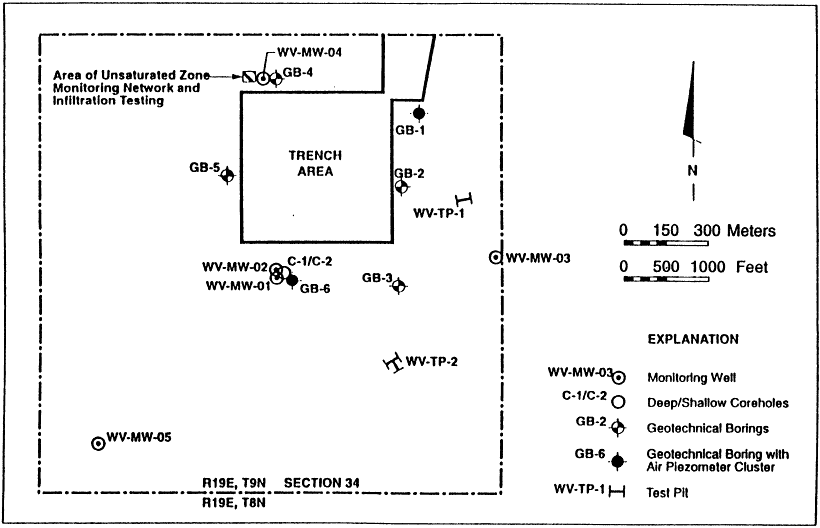
Ground-Water Monitoring
It is stated in the license application that long-term operational ground-water monitoring will be limited to four locations. One existing well, MW-04, will be upgradient from the facility. Three downgradient wells are proposed (wells MW-10, 11, 12). These locations are shown in Figure 6.2. In the latest information the committee received from U.S. Ecology, it is stated that monitoring will likely continue in existing monitoring wells MW-01,02, 03, 05 (Harding Lawson Associates, 1994). The new monitoring wells will be screened in the upper 15 m of the saturated zone and the lower 3 m of the unsaturated zone. Wells will be sampled quarterly during the operational and post-closure period. Ground-water samples will be analyzed for major ions and basic radiological parameters (LA Section 4400, Table 4400-1). A parameter value larger than the background value plus three standard deviations will be considered a statistically significant change in solute concentration. The limited number of monitoring wells in the saturated zone is defended by U.S. Ecology on the grounds that the comprehensive unsaturated-zone monitoring program ensures site performance (Harding Lawson Associates, 1994).
Committee Observations and Recommendations on Ground-Water Monitoring
Investigation and Action Level Response Plan
It is the committee's view that the response plan to investigation or action-level exceedance, although lacking details at this stage, generally appears to be adequate and appropriate. Without knowing the details of the nature of the action-level exceedance and its causes, it is not feasible to state in advance what specific response actions would be most appropriate. However, the plan appropriately places responsibility on the operator to develop an adequate response plan that is acceptable to the regulator. The process outlined to assess the exceedance data and to determine the proper response action appears to the committee to be adequate.
Oversight Advisory
The committee reiterates here the recommendation that the applicant consider an independent scientific oversight advisory panel of experts to review and make recommendations on all monitoring data. In the event of an exceedance of an investigation-level or action-level criterion, the oversight panel committee would review the data and the proposed response plan and present recommendations to the DHS.
Placement of Monitoring Wells
The committee considers that the proposed spacing of monitoring points along the southern and eastern perimeters of the radiological control area may not be adequate (Figure 6.2), given the lateral extent of the facility and the likely areal extent of any contaminant plume at the water table. It is our opinion that each of the southern and eastern perimeters of the radiological control area has no fewer than four monitoring wells, inclusive of comer monitoring locations (i.e. a total of eight monitoring wells). In addition, to establish better background databases, the western and northern perimeters should be equipped with no fewer than three monitoring points (i.e. a total of three background wells).
In the view of the committee, although the site-characterization borehole MW-02 is not suitable for monitoring the water table, it is suitable for monitoring deeper migration of contaminents.
The committee does not see the need to position any ground-water monitoring wells beyond the boundaries of the disposal facility.
Well Construction
We recommend that the monitoring wells be of appropriate construction and design to ensure monitoring of the uppermost saturation zone, (e.g., screened interval from 1.5 m above to 3.5 m below the water table), and a deeper zone (arbitrarily an interval 28 to 33 m below the water table). In this manner, water chemistry changes from samples at two horizons at the same location, as well as fluid potential within the two horizons, will be established. These databases are more useful to recognize changes occurring in water chemistry over time caused by leachate reaching the zone of uppermost saturation. Furthermore, they may detect changes in vertical fluid potential that could be related to local recharge.
Drilling Methodology
We recommend that the methodology used for drilling the monitoring boreholes be based on a dual-wall reverse-circulation air-rotary system. This technology produces the best control during drilling for identifying the depth of apparent uppermost saturation and permeable zones, as well as vertical differences in fluid potential. The technique creates a clean borehole for final well configuration and also tends not to damage significantly formation properties next to the borehole. The committee believes this basic drilling technology and strategy of vertical-profile monitoring, beginning at the uppermost saturation and extending to the first zone of important relative permeability as indicated by air-lifted water production during drilling, would be appropriate for the primary objectives of the saturated-zone monitoring.
REFERENCES
Arian-Tee Inc. 1991. Environmental Monitoring Report for the Proposed Ward Valley Low-Level Radioactive Waste Disposal Facility. Prepared for the Department of Health Services.
Brandt, E. C. October 7, 1994. Summary submittal of the California Department of Health Services to National Academy of Sciences Committee to review specific scientific and technical issues related to the Ward Valley, California LLRW site.
Campbell, A. C., F. W. Ross, and T. J. Nicholson. 1993. Low-level radioactive waste performance assessment technical issues and branch technical position. Proceedings of the Symposium on Waste Management. Tucson, Arizona. 367-370 pp.
Department of Health Services. 1993. Radioactive Material License issued to U.S. Ecology. September.
Estrella, R., S. Tyler, J. Chapman, and M. Miller. 1993. Area 5 site characterization project-report of hydraulic property analysis through August 1993. Desert Research Institute, Water Resources Center. 45121:1-51.
Harding Lawson Associates. 1994. Letter Report to Ms. Ina Alterman; Interpretation of groundwater quality data; Ward Valley. California. Dated October 6, 1994.
License Application. 1989. U.S. Ecology, Inc. Administrative Record, Ward Valley Low-Level Radioactive Waste Disposal Facility, Section 4400.
Prudic, D. 1994. Personal Communication.
U.S. Code of Federal Regulations. 1982. Licensing Requirements for Land Disposal of Radioactive Waste . Part 61: Title 10. Washington, D.C.: U.S. Government Printing Office.
U.S. Ecology. 1991. Environmental Monitoring Report for the Proposed Ward Valley Low-Level Radioactive Waste Disposal Facility. Prepared for the Department of Health Services. December 12.
Wilshire, H. G., K. A. Howard, and D. M. Miller. 1993a. Memorandum to Secretary Bruce Babbitt. June 2.
Wilshire, H. G., K. A. Howard, and D. M. Miller. 1993b. Description of earth science concerns regarding the Ward Valley low level radioactive waste site plan and evaluation. Released December 8.


