
2
SETTING OF THE WARD VALLEY SITE
LOCATION
The proposed Ward Valley low-level radioactive waste (LLRW) disposal facility is in the arid eastern Mojave Desert of southeastern California, approximately 30 km1 west of the city of Needles (Figure 2.1). Ward Valley trends north-south for about 85 km. It is bounded on the west by the Piute, Little Piute, and Old Woman Mountains and on the east by the Sacramento, Stepladder, and Turtle Mountains. The axis of Ward Valley slopes gently to the south, ranging in elevation from more than 650 m near the north end and the flanks of the valley to a low of 186 m at the southern terminus of the valley at Danby Dry Lake. The valley is drained by Homer Wash, which flows south and discharges into Danby Dry Lake (Figure 2.2). Homer Wash and Danby Dry Lake are both generally dry except during and immediately alter heavy rainfalls.
The proposed facility is located about 20 km from the northern end of Ward Valley, approximately 1.5 km south of Interstate 40 in the northeastern quarter of Section 34, Township 9 North, Range 19 East, San Bernardino Baseline and Meridian. The site is about 760 m west of Homer Wash (Figure 2.3): on a broad, low-relief alluvial surface that slopes gently (2 percent grade) eastward from the Piute Mountains toward Homer Wash. The site is at an elevation of 650 m, 17 m above the calculated 100-year flood in Homer Wash. The 100-year flood is the level to which flood waters are statistically predicted to rise an average of once in a hundred years. The distance from the proposed site southward to Danby Dry Lake is approximately 65 km.
GENERAL FACILITY DESCRIPTION
The disposal site, as defined by the Nuclear Regulatory Commission in 10 CFR Part 61, includes the LLRW disposal unit area, or "radiological control area", and a surrounding buffer zone. The State of California would control an approximately square area of about 405 hectares (ha) (1000 acres) consisting of Section 34, the south half of the south half of Section 27, the west half of the west half of Section 35, and the southwest quarter of the southwest quarter of Section 26, as shown in Figure 2.4.
The proposed radiological control area, surrounding buffer zone, and a facilities area are all contained within Section 34 and the 405 ha (1000 acres).
|
1 |
The metric system is used for measurements throughout the report. Because of common usage, not all measurements were converted from English units. For details of the conversion from English to metric units, please refer to Appendix C. |
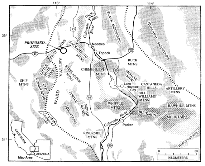
Figure 2.1 Location map of Ward Valley proposed facility site (![]() ), showing the approximate limits of the Colorado River extensional corridor (thick dashed lines). Shaded areas are mountain ranges. Metamorphic core complexes are marked by diagonal linear patterns. (Modified from Nielson and Beratan, 1995, as cited in Wilshire et al., 1994).
), showing the approximate limits of the Colorado River extensional corridor (thick dashed lines). Shaded areas are mountain ranges. Metamorphic core complexes are marked by diagonal linear patterns. (Modified from Nielson and Beratan, 1995, as cited in Wilshire et al., 1994).
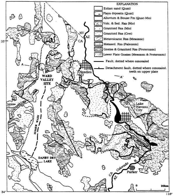
Figure 2.2 Geologic map of the region around Ward Valley. A-A' designates line of section of Figure 2.6. (Wilshire et al., 1994)
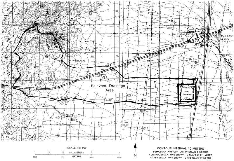
Figure 2.3 Topographic map with location of the site, Homer Wash, the relevant drainage area, and Interstate I-40. Details of the site location are found in Figure 2.4. (modified from USGS, 1984)

The proposed disposal facility consists of the following major elements (Figure 2.5):
-
A 532 m × 532 m, approximately 28 ha (70-acre), radiological control area surrounded by an electrified security fence, within which near-surface LLRW disposal operations will take place in a series of five progressively developed trenches. Four Class A waste trenches and one Class B/C trench are planned within a 471 m × 471 m trench area. Within the security fence zone, the waste trench area is surrounded by a permanent flood protection berm 1.5 m high on the western upgradient side and 0.9 m high on the eastern downgradient side. The buffer zone will extend 122 m around the entire perimeter of the 532 meter-square fenced control area for carrying out environmental monitoring activities, maneuvering construction equipment, and allowing corrective actions to be implemented. Additional details of the radiological control area and waste trench features are described in Chapter 7.
-
An adjoining fenced facilities area of about 3.1 ha (7.6 acres) in the northeast comer of the disposal site containing vehicle parking and staging areas, fuel and water tanks, utilities, a sanitary waste disposal system, a facility operations building, a shop building, test trenches, and a security guard house located at the facility's only entrance gate;
-
A series of 0.3 m high drainage berms (called "breakup berms") to the west, upgradient of the disposal area, for increasing the surface roughness and for temporarily diverting shallow surface flow around the control site during construction;
-
A meteorological and air-quality monitoring station approximately 90 m southwest of the southwest comer of the facility's security fence;
-
Other site elements, including five ground-water monitoring wells and additional environmental monitoring stations (Figures 2.4 and 2.5).
REGIONAL GEOLOGIC SETTING
The geologic history of the eastern Mojave Desert spans more than 1.7 billion years (Howard et al., 1987; Wooden et al., 1988; Wilshire et al., 1994) and is very complex, reflecting multiple episodes of tectonism2, or large-scale movements, disruptions and heating of the earth's crust, such as faulting, folding, mountain building, metamorphism, and magmatism. The tectonic history can be subdivided into five major phases:
-
Early to Middle Proterozoic3 (from about 1.1 to about 1.8 billion years ago (Ga)) deposition, deformation, metamorphism, and magmatism, resulting in the formation and stabilization of continental crust;
-
Latest Proterozoic, Paleozoic to early Mesozoic sedimentation on a stable shelf;
-
Middle through late Mesozoic arc magmatism, tectonism, and regional uplift;
|
2 |
See Appendix D, Glossary of Terms, for definitions of geologic and technical terms. |
|
3 |
See Table 2.1, Geologic Time Scale, for definitions of geologic time periods. |
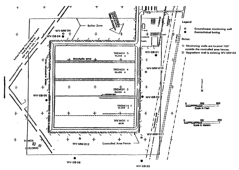
Table 2.1 Geologic Time Scale
|
Era |
Period |
Epoch |
Beginning of epoch or period (millions of years ago) |
|
Phanerozoic Cenozoic |
Quaternary |
Holocene |
0.01 |
|
|
|
Pleistocene |
1.6 |
|
|
Tertiary |
Pliocene |
5 |
|
|
|
Miocene |
24 |
|
|
|
Oligocene |
37 |
|
|
|
Eocene |
58 |
|
|
|
Paleocene |
66 |
|
Mesozoic |
Cretaceous |
Late (upper) |
|
|
|
|
Early (lower) |
144 |
|
|
Jurassic |
Late (upper) |
|
|
|
|
Middle |
|
|
|
|
Early (lower) |
208 |
|
|
Triassic |
Late (upper) |
|
|
|
|
Middle |
|
|
|
|
Early (lower) |
245 |
|
Paleozoic |
Permian |
|
286 |
|
|
Pennsylvanian |
|
320 |
|
|
Mississippian |
|
360 |
|
|
Devonian |
|
408 |
|
|
Silurian |
|
430 |
|
|
Ordovician |
|
505 |
|
|
Cambrian |
|
570 |
|
Precambrian Proterozoic |
|
|
2500 |
|
Archaen |
|
|
4550(?) |
-
Cenozoic (Miocene) crustal extension and broadly synchronous sedimentation and magmatism; and
-
Late Cenozoic post-extension erosion of the mountain ranges, filling of the intervening basins with the resulting sediments, and partial integration of drainage systems during a time of relative tectonic stability.
The three pre-Cenozoic phases, i.e. before 66 Ma, produced much of the complex geology found in the mountain ranges (Figure 2.2), including fracture permeability of the basement rocks, but otherwise have relatively minor implications for assessing the proposed Ward Valley site. In contrast, the two Cenozoic phases, i.e. Miocene crustal extension, sedimentation, and magmatism, and late Cenozoic erosion, produced the present-day surface appearance, or physiography, of mostly north- and northwest-trending mountain ranges surrounded by sediment-covered basins, and have much greater relevance to the site.
PRE-MIOCENE GEOLOGIC HISTORY
Proterozoic Era
The oldest rocks in the region are Proterozoic metamorphic and plutonic rocks that were subjected to extremely high temperatures and pressures resulting from great tectonic forces at about 1.7 Ga (Wooden et al., 1988; Wooden and Miller, 1990; Foster et al., 1992). These rocks, exposed in the Piute and Sacramento Mountains, record the formation and subsequent stabilization of the region's continental crust. One of the most extensive Proterozoic rock units in the region is the 1.68-Ga Fenner Gneiss, a coarse-grained biotite granite gneiss that forms dark-colored outcrops throughout the Piute and northwest Sacramento Mountains (Miller et al., 1982; Wooden and Miller, 1990; Bender, 1990; Karlstrom et al., 1993). Other Proterozoic units include Middle Proterozoic syenite (1.4 Ga) and diabase (1.1 Ga) in the Piute Mountains (Howard et al., 1987).
Paleozoic Era
Regional uplift and erosion during Middle to Late Proterozoic time brought the deeply formed metamorphic and plutonic rocks to the surface, where they were eroded to a low-relief surface. These rocks subsequently were overlain by approximately 1 to 1.5 km of Paleozoic and Early Mesozoic (Triassic) sedimentary rocks of similar age and composition as those exposed in the Grand Canyon (Stone et al., 1983). The sedimentary rocks are mostly sandstone, shale, and limestone that were deposited in a shallow sea and accumulated on a tectonically stable part of what was then near the coast of western North American. Small, discontinuous remnants of these Paleozoic and Triassic strata, which were deformed and metamorphosed later, are exposed in the Piute and Little Piute 1988; Fletcher and Karlstrom, 1990). Mountains, west of Ward Valley (Howard et al., 1987; Hoisch et al.,
Mesozoic Era
During Late Triassic through Cretaceous time, southern California was the site of intense deformation and granitic magmatism caused by the convergence of tectonic plates along the west coast. Near Ward Valley, this convergence resulted in regional compression which caused thrusting and metamorphism of the Triassic, Paleozoic, and older rocks. Mesozoic granitic plutons invaded the region on the eastern fringes of the Mesozoic batholith belt that includes the Sierra Nevada and Peninsular Ranges batholiths (Miller et al., 1992). Light-colored Mesozoic granitic plutons, such as those exposed in the Piute, Stepladder, and Old Woman Mountains (Howard et al., 1987), were emplaced in the Late Cretaceous and then rapidly cooled and uplifted (Foster et al., 1989, 1990, 1991, 1992).
A lack of Early Tertiary sedimentary or volcanic rocks in the region, in conjunction with evidence from adjacent areas (Bohannon, 1984; Reynolds et al., 1988; Christiansen and Yeats, 1992), suggests that the region remained a topographically positive area, i.e., an upland rather than a basin, from the end of the Mesozoic throughout the first half of the Cenozoic Era.
Cenozoic Era
Miocene Extension and Magmatism
The present-day basins and ranges in the Ward Valley area formed when the earth's crust in the region was pulled apart, or extended, in Miocene time (Howard et al., 1982; Spencer, 1985; Howard and John, 1987). Ward Valley lies along the western side of a 50- to 100-km wide belt of extreme crustal extension that trends northward along the Colorado River (Figure 2.3 and 2.6). Along this belt, Miocene extension stretched the crust to twice its original width in an east-west direction (Howard and John, 1987). Extension began prior to 20 Ma, had largely ended by 13 to 12 Ma (Spencer, 1985; Hillhouse and Wells, 1991; Foster et al., 1990), and was accompanied by volcanism and the emplacement of dikes, sills, and small plutons.
Block Faulting
The extensional event left the region with two very different types of geologic terrain separated by one or more gently dipping regional faults. The first type of terrain consists of north- to northwest-trending fault blocks, in which highly tilted Miocene volcanic and sedimentary strata rest on older rocks. Examples of such fault blocks are present in the Stepladder and Turtle Mountains.
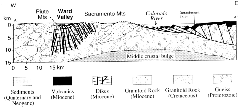
The second very different type of terrain consists of deeply formed plutonic and metamorphic rocks that are relatively unfaulted, but instead were heated, sheared, extensively fractured, and contorted in Miocene and earlier times. These deep-level rocks are now exposed at the earth's surface in a belt of mountain ranges, termed metamorphic core complexes. They border the west side of the Colorado River and include, from north to south, the Dead, Sacramento, Chemehuevi, and Whipple Mountains (Figure 2.1).
Detachment Faulting
Separating the two terrains are one or more major normal faults, termed detachment faults. These formed as a thick slab of the upper crust slipped over the underlying crust along a gently sloping (or dipping) fault surface, which in this case sloped toward the east (Figure 2.7). Warping of the detachment faults during crustal extension gave them a dome-like shape over the core complexes (Figure 2.8). The faults are exposed on the flanks of the core-complex ranges, where they juxtapose the tilted fault blocks and associated Miocene volcanic and sedimentary rocks against the underlying deep-level rocks within the ranges (Figure 2.8).
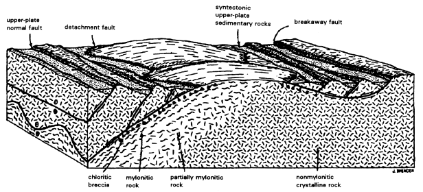
Figure 2.7 Block-diagram of a typical metamorphic core complex and detachment fault, showing the domal form of the complexes and the titled fault blocks above the fault. Greater amount of fracturing typical of upper plate rocks shown by block faulting (Spencer and Reynolds, 1989).
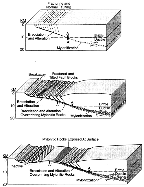
Figure 2.8 Interpretive model for the evolution of detachment faults and metamorphic core complexes. Normal displacement along the low-angle shear zone produces mylonitic (ductile) fabrics at depth and more brittle (fracturing) structures along shallower segments of the fault. As the lower plate becomes less deeply buried with time due to tectonic removal of the overlying rocks, mylonitic rocks are overprinted by successively more brittle structures. Isostatic adjustments lead to the warped, domal geometry of the detachment fault and mylonitic fabrics. In this model the Ward Valley site would be located above the detachment near the word ''inactive'' on the left side of the bottom figure. The Sacramento Mountains are represented by the mylonitic rocks exposed at the surface (Reynolds et al., 1988).
The detachment faults are interpreted to be present deeper in the crest beneath much of the region (Howard et al., 1982; Spencer, 1985; Howard and John, 1987; Okaya and Frost, 1986), including beneath the proposed LLRW site (Figure 2.9). Most detachment faults are marked by zones of fractured and crushed rock several tens of meters to hundreds of meters thick. During the faulting, hot, chemically rich, ground water passed through and altered the rocks, depositing minerals in the fractured zones as it cooled (Reynolds and Lister, 1987; Roddy et al., 1988; Spencer and Welty, 1989).
A model for the evolution of detachment faults and metamorphic core complexes is shown in Figure 2.8 (Wernicke, 1981; Davis et al., 1986; Howard and John, 1987; Reynolds et al., 1988). In this model, the upper 10 to 15 km of the crest exhibited brittle behavior during extension and broke up into large blocks bounded by normal faults (Figure 2.7). In contrast, rocks in the middle and lower crust, below approximately 15 km, were hot enough, or compressed enough by the overlying crust, to accommodate the extension by ductile, or viscous, flow. These mid-crustal rocks were uplifted to the surface by tens of kilometers of normal displacement along the east-dipping detachment fault. In essence, the deep-level rocks in the California core complexes were pulled out from beneath upper-crustal rocks of western Arizona (Reynolds and Spencer, 1985; Davis et al., 1986; Howard and John, 1987; Davis, 1988; Davis and Lister, 1988).
According to this model, faulting was accompanied by tilting of the blocks, leaving some on end. The Miocene basins formed on the down-dropped pans of the blocks and were filled with volcanic and sedimentary material, including huge landslide rock masses derived from uplifted parts of the blocks. The doming, or upwarping, of detachment fault surfaces is interpreted to have occurred during extension and to be an isostatic response to tectonic unroofing (Spencer, 1985; Howard et al., 1982; McCarthy et al., 1991). Tectonic unroofing refers to the removal of a large overlying rock mass by slippage down a detachment fault. The removal of this dense mass allowed the underlying rock to rebound upward to some equilibrium level, analogous to the way in which a floating block of wood, pushed underwater by a weight, will bounce back to its equilibrium floating position when the weight is removed. The rise of the depressed rock alter removal of its "roof" is referred to as isostatic rebound.
The detachment fault may be Warped up and over the Sacramento Mountains (Figure 2.9). Alternatively, the detachment beneath Ward Valley could continue dipping gently to the east and go beneath the Sacramento Mountains. In this latter case, the detachment fault exposed in the Sacramento Mountains would be a structurally higher detachment that is not continuous with the fault that underlies the proposed site.
Present-day ranges in the region, therefore, represent (1) single huge tilt blocks or series of tilt blocks above the regional detachment fault (Figure 2.7), (2) uplifted domes of deep-level rocks beneath the warped fault (Figure 2.8), or (3) untilted fault blocks outside the belt of major extension (Davis et al., 1980, 1986; Howard et al., 1982; Howard and John, 1987; Spencer and Reynolds, 1989).
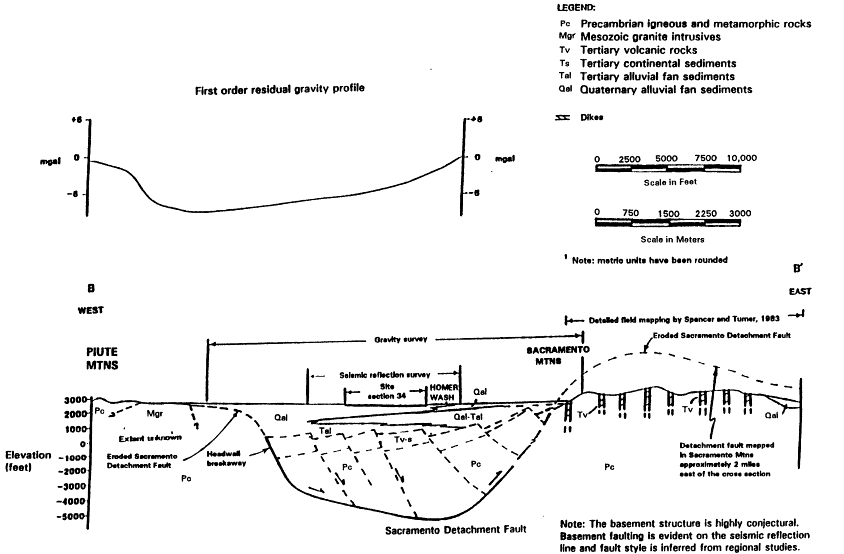
Figure 2.9 Interpretive cross section of the Ward Valley site based on geological, geophysical, and hydrologic data. Section location is on LA Figure 2310.1, approximately the same location as Figure 2.6 (LA Section 2310).
Post-Extension Geologic Evolution and Landscape Development
Late Faults
Major extension and detachment faulting ended between 15 to 12 Ma based on the age of gently dipping volcanic flows that either overlap the detachment fault or unconformably overlie highly tilted Miocene strata in the Sacramento Mountains and elsewhere in the region (Spencer, 1985; Howard and John, 1987; Simpson et al., 1991). A younger, post-detachment reverse fault cuts 12 Ma basalt and conglomerate along the west side of the Dead Mountains (Spencer, 1985). Regionally, these faults do not cut latest Tertiary and Quaternary surficial deposits and are probably middle to late Miocene in age. Although a few minor fault scarps have been identified cutting post-Miocene deposits near Topock, Chemehuevi Valley, Danby Dry Lake, and other locations within 80 km of the proposed facility (Wilshire et al., 1994), at the present time Ward Valley lies within one of the most seismically inactive parts of southern California (Figure 2.10).
Basin Fill
During and subsequent to detachment faulting, erosion of the mountain ranges shed clastic, or fragmented rock, material into the flanking intermountain basins. Late Miocene and younger basin-fill strata dip gently throughout most of the region and unconformably overlie the tilted mid-Miocene and older rocks. Most of the rock fragments are locally derived and can be traced to the adjacent ranges (Metzger and Loeltz, 1973; Dickey et al., 1980; Cart, 1991). The basin fill commonly contains boulders and coarse gravels adjacent to the mountain fronts and becomes progressively finer grained toward the center of the basin (Figure 2.11). The size of clasts, or rock fragments, may also vary as a function of age of the deposit, largely due to variations in climate during the Pleistocene (Dickey et al., 1980; Menges and Pearthree, 1989; Demsey, 1989). Basin-fill and alluvial deposits commonly are relatively unconsolidated near the surface and become more consolidated, or hardened, with depth from compaction and precipitation of mineral material in the pores between the grains.
Some basin fill deposits contain halite (salt) and other minerals that form by evaporation of the water in which the chemicals are dissolved, especially near the sites of former and present-day playas (dry lake beds) and lakes (Scarborough and Peirce, 1987). In addition, locally derived basin fill in the Colorado River valley interfingers with the late Miocene to Pliocene Bouse Formation, which accumulated in a brackish water estuary (salty, but less than sea water), probably linked to a proto-Gulf of California (Metzger and Loeltz, 1973; Lucchitta, 1979).
Based on drilling and geophysical data, the alluvial and basin-fill deposits are interpreted to be more than 600 m thick below the site (Figure 2.9). Basin fill is generally thickest near the center of a modem basin and thins gradually next to the flanking mountain
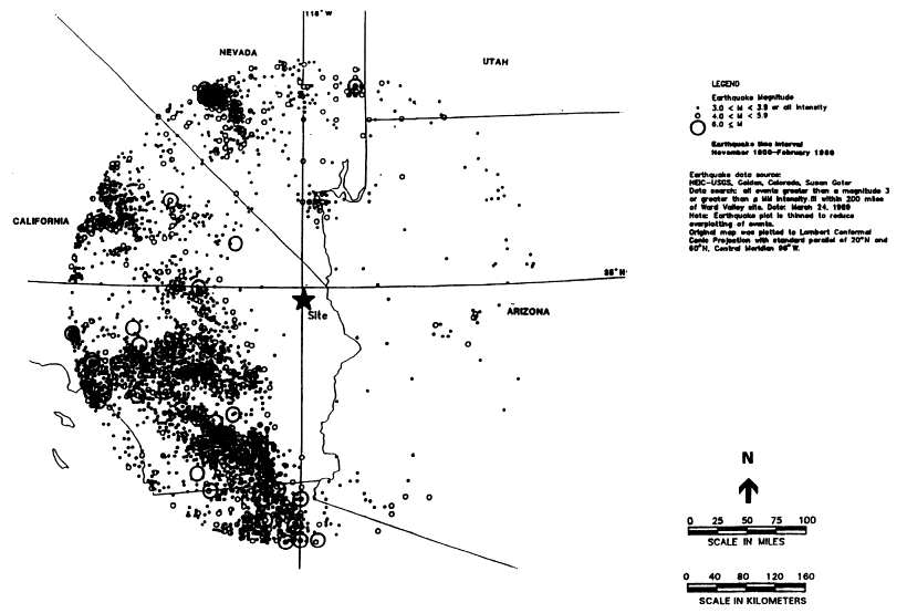
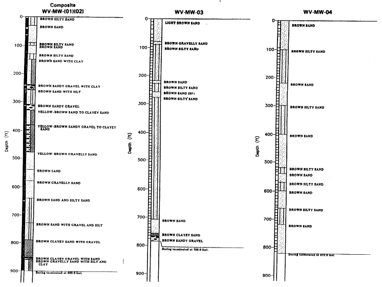
Figure 2.11 Well boring logs of alluvial sediments showing the character and variability of fan deposits. (Measurements originally taken in feet, not converted to metric). Locations of boreholes are found in Figure 2.4. (Harding Lawson Associates, 1991)
ranges. The basin fill takes the form of alluvial fans, which are gently sloping accumulations of intermittent stream deposits, and are common adjacent to mountain fronts. The fans may coalesce toward the basin, forming a bajada, a broad, low-relief feature that occurs at the proposed LLRW site.
The relative volumes of older (Miocene and Pliocene) basin fill versus Quaternary basin fill and alluvium is unknown. A fairly young age for some basin fill is indicated at Danby Dry Lake, where fossiliferous beds correlated with the Pliocene and upper Miocene Bouse Formation (Calzia, 1992) are overlain by 150 m of Pliocene and younger sediments (Wilshire et al., 1994).
The Ward Valley basin-fill deposits are interpreted to unconformably overlie highly faulted Miocene sedimentary and volcanic rocks that dip moderately to the west and that are in the upper plate of the regional detachment fault. A strong reflector, which is a surface deep within the crust that reflects acoustic or seismic waves, interpreted on a seismic reflection profile to be the detachment fault, dips gently to the east beneath the site at a depth of approximately 1.5 to 2 km. This detachment fault, when projected up-dip to the west, would probably reach the surface along the front of the Piute Mountains (Figure 2.9). The from of the Piute Mountains is interpreted to be the breakaway for the detachment, the place where the normal fault originally broke to the surface. Less faulted, more deep-level rocks, including metamorphic and granitic rocks similar to those in the Piute Mountains, are probably present beneath the detachment fault and its associated fractured and brecciated zone.
GEOMORPHOLOGY
The Ward Valley site and surroundings comprise three main geomorphic elements relevant to surficial processes and stability: (1) bounding mountain ranges trending approximately north - south, (2) gently sloping coalescing alluvial fan deposits on both sides of the valley forming bajadas, and (3) a mid-valley drainage (Homer Wash) with a north to south gradient. The local topographic features and geomorphology reflect the physiography of the Colorado River extensional corridor (Figure 2.1) and climate.
The Piute Mountains west of the site, where drainage across the alluvial fan originates, are the source of the sediments at the site surface. The Sacramento Mountains to the east of Homer Wash, across the valley from the Ward Valley site, shed sediments forming alluvial fan deposits east of Homer Wash.
The drainage channels in the vicinity of the site are very shallow and are interwoven into a braided network. Shallow channels indicate little incising or downcutting within the channels, and, in this area of low rainfall, all flow is ephemeral.
A single geomorphic surface covers much of the site area. The thin alluvial deposits on this surface are designated Qf1. Qf1 deposits show no soil development (LA Appendix 2310.A (Shlemon)), and, therefore, are inferred to be geologically young with immature soil development. The network of rills or shallow channels is developed on this surface in the vicinity of the site.
Local areas, slightly higher up the fan slope than the surface of Qf1, are underlain by moderately developed relict calcic soils (also commonly called caliche, see Box 2.1) or paleosols underlying a surface designated Qf2. These Qf2 paleosols also underlie much of the area under thin Qfl deposits. From regional relationships, Qf2 paleosols are estimated to be 35,000 (35 ka) to 40,000 years (40 ka) and a deeper paleosol (Qf3), about 100 ka (LA Appendix 2310.A (Shlemon)). These calcic soils are consistent with limited rainfall for much of the period since formation.
The site features, i.e., surface deposits, paleosols, and the network of very shallow drainage channels indicate very little large-scale erosion or channelling under natural conditions for thousands of years. This observation is evidence for a relatively stable surface for the past thousands to tens of thousands of years.
Late Tertiary and Quaternary landscape development was strongly influenced by the local base level, the lowest level to which surface water flows within a drainage basin. Basins that are internally drained and unconnected with the regional drainage network or river system, such as Ward Valley, tend to be topographically higher and less deeply carved by surface water flow than basins of equivalent age along the Colorado River. Because the Colorado River is topographically lower, and the drop to the lower base level along the river is relatively rapid, it resulted in more erosional downcutting by rivers, removal of basin fill, and a lower overall elevation of the basin floor, for those basins that are connected with the regional drainage network leading to the Colorado. Drainages within the Colorado River trough carved deeply into the adjacent mountain ranges, commonly causing the ranges to be steepest and have their greatest local relief on the side facing the Colorado. The Stepladder Mountains and Sacramento Mountains display this topographic asymmetry.
The geomorphology and surface stability are discussed in more detail in Chapter 7 in relation to engineering considerations.
SUBSURFACE GEOPHYSICAL DATA
To characterize the site, geophysical methods have been used to constrain the depth and configuration of the boundary between basin fill and underlying bedrock and the depth to the water table.
The bedrock surface configuration at the proposed LLRW site is constrained by geologic, gravity, seismic-reflection, and ground-water data. This data set forms a basis for extrapolation and calibration of all data sets and also for extrapolation to the remainder of Ward Valley where the subsurface data are sparse. The geologic cross section (Figure 2.9) through the site effectively integrates these data sets into one interpretation of the geology across Ward Valley. Because of the nonuniqueness of these and all other geophysical and subsurface geologic data sets, however, other interpretations are possible.
The drill holes (LA Section 2320, Figure 2320 B-1), seismic reflection data, and electrical resistivity data (LA Section 2320, Figure 2320 B-6) provide useful information on the depth to the water table in the vicinity of the proposed LLRW site. These data also provide information on the possible existence of Tertiary ("old") alluvium and the geometry of
|
BOX 2.1 Background on "Caliche" or Calcic Soils The term "caliche" has been, and is, commonly taken in southwestern United States to mean a calcareous or calcite-cemented unit developed by soil processes. However, this word has also been applied to other types of units. Currently, because of the broad and rather non-specific meaning the term has acquired, many geologists and soil scientists prefer the terms "calcic soil" or "pedogenic calcrete" as more precise (Machette, 1985). In addition to common soil unit identifiers, Shlemon (Appendix 2310.A) uses similar terms to describe the near-surface paleosols. It is clear from the context that, whatever the terminology used for the Ward Valley site, these units in the upper part of the sedimentary sequence are thought to be generally pedogenic in origin. Soil scientists have developed specific nomenclature for the soil horizon developed in calcic soils (Gile and others, 1965). The "K horizon" is the master soil horizon, equivalent to more widely applied A, B, and C horizons. The K. horizon has a very strong carbonate cemented fabric. Weaker calcic horizons are designated by k (e.g., Bk, as in LA Appendix 2310.A). Soils, including calcic soils, are the product of both environment and length of time over which they develop. The percentage of carbonate increases with depth in the soil and then decreases with depth still lower in the soil. The thickness of the subsurface soil horizons (e.g., B and K horizons), and the strength of individual soil properties used to describe the soil, increase with increasing age of the soil. Beneath progressively older surfaces the carbonates are progressively better developed. Calcic soils have been usefully classified in six stages (I-VI), from least to greatest morphological development, by Bachman and Machette (1977, p.40). Within the administrative record, the near-surface calcic soils have been classified as stages II-III based on morphology. These stages commonly display a range of carbonate, from grain coatings and little matrix carbonate to continuous dispersion of carbonate in the matrix. At Stage II, clasts, or rock fragments, may show thin coatings of carbonate, and nodules develop where gravel content is low. By Stage III, cements between soil particles can be quite firm. The main hallmark differentiating these stages from Stage IV is the lack of platy to tabular structure within the K-fabric. Stages IV-VI show increasing induration, or hardness and platy, tabular, or laminar structure. Calcic soils at the Ward Valley site are not reported to show any of these more advanced morphologies. Calcic soils develop with surface stability and appropriate climate. Because of the moderate solubility of calcium carbonate, greater rainfall and infiltration flushes carbonate components from the soil profile. In areas with higher rainfall, calcic soils rarely develop. Climatic changes, with increased rainfall, can destroy an existing calcic soil, and climatic fluctuations between arid and more humid environments can produce complex calcic soils or pedogenic calcretes such as the caprock on the Miocene Ogallala Formation exposed in eastern and southeastern New Mexico (Bachman and Machette, 1977). Calcic soils develop within the soil profile in a zone reflecting the mean annual depth of penetration by soil water (Bachman and Machette, 1977). The persistence of calcic soils at these depths indicates that the rainwater infrequently (or maybe never) reaches that level in large enough quantities to dissolve them. Carbonate sources include soil gases from plant cover (e.g., Cerling and Quade, 1993), rain water, dust, and dissolved CO2 in rainwater (Machette, 1985). Quade and others (1989) and Cerling and Quade (1993) demonstrate for calcic soils that soil carbon is generally equilibrated with soil gases characteristic of the plant cover and that oxygen in pedogenic carbonates is equilibrated with rainwater. Calcium sources include exposed older limestone formations, soil minerals, dissolved calcium in rainwater, and eolian dust. Test pits at the Ward Valley site showed macromorphology and features interpreted by Shlemon (Appendix 2310.A) as soils or paleosols. In addition, some of the micromorphologies (pendulous calcite cement at 28.4 ft. depth, Figure 2310.A-11) are also indicative of pedogenic processes. The evidence presented within the administrative record is consistent with the presence of several calcic paleosols or pedogenic calcretes within the sequence. The calcic soils are appropriately classified as Stage II-III. |
a number of bedrock structures. The seismic reflection records contain the best information available on the configuration of the bedrock surface, and form the primary basis, along with projection of surface geologic data, for suggesting that an irregular bedrock surface topography exists beneath the alluvial fill in Ward Valley.
Residual Bouguer gravity data for Ward Valley and vicinity, with the regional field removed (LA Section 2320, Figure 2320 B-12), provide a less precise means to extrapolate the configuration of the bedrock surface from the site throughout the area. Gravity data in the Basin and Range generally outline the configurations of basins and ranges, with highs mostly corresponding to ranges and lows mostly corresponding to basins. Using these observations and the detailed gravity profiles at the site and south of it in Ward Valley, two-dimensional models can be employed for interpretation of the bedrock surface topography in the northern two-thirds of Ward Valley (LA Section 2320, Figures 2320 B-9, B-14, B-15, B-16, and B-17). The bedrock surface configuration is portrayed as a narrow-floored, V-shaped canyon located west of the present-day Homer Wash drainage in a diagram by Harding Lawson Associates (Figure 2.12a). Based on these data sets, this is but one of several permissible interpretations of the available geologic, drilling, and geophysical data. Other permissible interpretations range from a simple flat-bottom valley to one interrupted by a tectonically derived fault-block topography (Figure 2.12).
Considering the residual Bouguer gravity profiles (particularly A-A' and D-D'; LA Section 2320, Figures 2320 B-9 and B-16) and the seismic reflection data (LA Section 2320, Figure 2320 B-6) in the site area, bedrock highs may exist down the axis of Ward Valley, but they probably do not intersect the present-day water table (Figure 2. 13).
Vertical electrical soundings were performed using a Schlumberger array, as described in LA Appendix 2320.B, Geophysical Investigations. The general findings, with the exception of the two easternmost resistivity sites, were a comparatively high resistivity zone, approximately 100-200 ohm meters, extending to a depth of about 215 m, underlain by a lower resistivity (higher conductivity) zone of approximately 20-50 ohm meters. This resistivity boundary was interpreted as the water table, and its depth and identity were later verified by drilling at the site.
The two easternmost resistivity sites straddle Homer Wash, and in them the lower resistivities, 50-60 ohm meters, extend upward nearly to the surface. These lower resistivities cannot reasonably be interpreted as a mound on the water table, because, for example, the seismic reflection from the water table continues undeflected through this area (Appendix 2320 B). These lower resistivities near Homer Wash indicate some combination of higher pore water, greater silt and clay content, or higher salinity within the unsaturated zone. A decrease in sediment particle size (increase in silt and clay content) is expected toward Homer Wash, the axis of Ward Valley, and recharge to the unsaturated zone is also expected along Homer Wash. Clays, in particular, tend to lower resistivity by adsorbing electrolytes and water, and by increasing electrical connectivity.
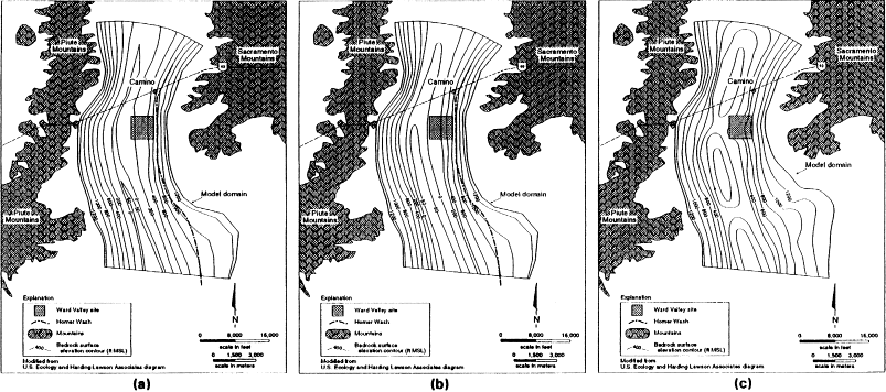
Figure 2.12 Bedrock surface topography in Ward Valley derived from gravity, seismic reflection, and other geophysical data. (a) Version presented in Harding Lawson's report (Eric Lappala presentation, August, 1994). (b) Version modified from (a) assuming a simple, broad, flat-bottom valley. (c) Further modification of (a) employing greater degree of interpretation of the residual Bouger gravity map to indicate possible fault-block modification of the bedrock surface paleotopography.
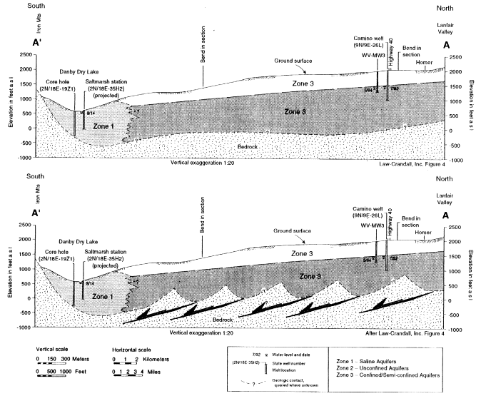
Figure 2.13 Longitudinal geologic sections through Ward Valley based on geologic, gravity, well and seismic-reflection data. (a) Interpretation presented in Law-Crandall, Inc. report (Figure 4). (b) Section modified from (a) assuming residual Bouger gravity to suggest that the axis of Ward Valley may consist of topography created by detachment faulting.
Climate
The climate of Ward Valley is typical of the eastern Mojave Desert. (Law/Crandall, 1992). Regional and local meteorological data reflect the climatic character of the Mojave Desert region for Ward Valley. Several sections of the administrative record provide general and specific data for the region and the Ward Valley site. There is no disagreement on the description of the general climatic characteristics of Ward Valley and the proposed site, though no long-term data from the site exist for engineering design.
The region is in a hot desert, with precipitation of 50 percent or less of potential evaporation and mean monthly air temperature of the coldest month greater than freezing. Winters are mild and summers are hot. The mean annual temperature is about 72°F (22°C) (Law/Crandall, 1992). Temperatures range from an extreme winter low of-2.4°C in January to extreme summer highs of about 49°C in July, with a wide daily temperature range (ca. 25°C) (LA Section 2200). Annual rainfall is estimated to be less than about 15 cm, and annual potential evapotranspiration is estimated between about 100 and 120 cm (LA Section 2200)4. Total annual pan evaporation based on five selected regional stations averages about 338 cm (LA Section 2200, Table 2200-6).
Some meteorological data were collected at the proposed radiological waste site from September 1987 through October 1988 (Harding Lawson Associates, 1994). For this one-year period, temperatures at a height above ground surface of 10 m ranged from 40.5°C to -3.3°C (LA Section 2200). At 0.5 m above the surface, the temperatures ranged from 43.9°C to -7.0°C. Rainfall data have been collected and reported at the site through August 1994 (Harding Lawson Associates, 1994b, 1994). For the 84-month period ending August 1994, monthly rainfall ranged from 0.00 cm (several months) to 11.5 cm (March 1992) and averaged 1.1 era/month. The 84-month period yields an average equivalent of 13.4 cm of precipitation per year.
The Mojave Desert is characterized by low (10-15 cm), bimodal but winter-dominated precipitation (ca. 65 percent; Rowlands, 1980). A long-term, combined rainfall data record in the region taken at Needles and Needles airport for the 80-year period, 1903-1983 reported an average annual rainfall for this station of 11.8 cm (see footnote page 2-24) for this 80-year period (LA Section 2200, Table 2200-4, Law/Crandall, 1992). Rainfall data at Needles/Needles Airport for a 99-year period from 1892 to 1990 showed the maximum annual total rainfall for Needles was 34.1 cm (1939). Twenty-one out of the 99 years had total annual rainfall in excess of 15.2 cm (Law/Crandall, 1992).
Homer Wash watershed hydrology for the upper part of Ward Valley, where the LLRW facility is located, is described in Chapter 7.
|
4 |
Note that rainfall figures vary slightly within this report depending on rainfall record location and period. Chapter 3 also uses rainfall to illustrate certain processes. The next paragraph gives more specific data from the Ward Valley site. |
SURFACE-WATER HYDROLOGY
Homer Wash is the principal drainage feature in Ward Valley. It begins in the northern part of the valley and extends to Danby Dry Lake (LA Section 2410). The channel is more than 760 m east of the LLRW site at its nearest point. The alluvial fan-bajada surface has numerous shallow channels that feed drainage to Homer Wash (Figure 2.2 and 2.3).
Homer Wash is an ephemeral stream draining Ward Valley from north to south in a rather straight course. Homer Wash has little potential to develop sinuosity or extensive floodplain deposits for two reasons: (1) alluvial fan systems between these ranges will tend to maintain Homer Wash in a mid-valley position as long as there is no uneven tilting across the valley; (2) denser vegetation persists along the channel banks because ephemeral runoff is concentrated and may penetrate more deeply.
Hydrologic Soil Group Classification
Ward Valley has been characterized in terms of four hydrologic zones: (LA Section 2410):
Zone 1 is the outcropping rock and shallow soil areas formed by the Piute, Sacramento, Old Woman, Stepladder, and Turtle Mountains on the eastern and western boundaries of the basin. The San Bernardino County hydrologic soil group classification map for Ward Valley assigns soils in Zone 1 to the ''D'' or high runoff, low infiltration potential soils group. About 12 percent of the basin is classified as Zone 1. For hydrologic evaluation purposes, and based on reported visual inspection, vegetation in Zone 1 is classified as desert shrub with poor to fair cover.
Zone 2 represents upland area valleys between rock outcrop areas whose soils are formed by alluvial outwash materials that have migrated from the surrounding mountains. Approximately 25 percent of the basin is in Zone 2. Zone 2 soils are classified as "C", moderately high runoff or moderately low infiltration potential soils group. Vegetation in this zone is classified as desert shrub with poor to fair cover.
Zone 3 occurs on valley side slopes, where alluvial outwash from the mountain areas has formed alluvial fans that have coalesced into a bajada. The elevations range between 186 m and 914 m in this zone. Soils in Zone 3 are grouped into the "A" classification, and are characterized by high infiltration or low runoff rate. Type A soils chiefly consist of well to excessively drained sands and gravels. Zone 3 vegetation, for hydrologic evaluation purposes, is classified as desert shrub with fair to good cover. A unique surface feature of Zone 3 is the occurrence of isolated "hardpan" areas of less than 04 ha to 17 ha (0.1 acre to 42 acres). Hardpan is characterized by a hard surface, low infiltration, reduced vegetation density, and a slightly raised elevation above surrounding areas. Zone 3 represents about 60 percent of the basin.
Zone 4 exists only in the northern pan of the Ward Valley Basin, where outcropping rock zones are not present on the basin boundary and different depositional processes from different source areas have occurred. Zone 4 soils fall into the "B" grouping, and are
classified as having moderate runoff and infiltration rates. This soil group consists mainly of moderately well to well drained soils with moderately fine to moderately coarse textures. Vegetation in Zone 4 is hydrologically classified as fair to good desert shrub cover. Zone 4 comprises about 3 percent of the Ward Valley Basin (LA Section 2410).
HYDROGEOLOGY
Features
The hydrogeological setting of Ward Valley has many features in common with other basins in the Mojave Desert: (1) the valley is bordered on the east and west by mountain ranges; (2) bedrock in the valley is buried beneath a thick sequence of alluvial sediments; (3) the alluvial sediments, which are more than 600 m thick within Ward Valley, form the main aquifer system; (4) bedrock is generally considered to be much less permeable than the basin-fill alluvium.
Recharge
As there is little historic or present use of ground water within Ward Valley, the database to characterize the regional ground-water system is sparse. Precipitation falling in the mountains surrounding Ward Valley is the principal source of ground-water recharge. Some of the precipitation will enter deep bedrock flow systems through fractures in the bordering mountains. The rates of ground-water flow in the bedrock depend to a large extent on the degree to which fractures enhance the permeability of these crystalline rocks. Surface runoff from the mountains infiltrates on the upper reaches of the alluvial fans as the water encounters the more permeable alluvial sediments. If rainwater is able to infiltrate beneath the active root zone, the possibility exists for a general pattern of recharge across the floor of Ward Valley. Infrequent, high-precipitation events could lead to sporadic but volumetrically important recharge events centered beneath Homer Wash. Recharge may also enter northern Ward Valley as subsurface inflow from Lanfair Valley (Figure 2.1). Law/Crandall (1992) has estimated the annual recharge to the ground-water system in Ward Valley to be in the range from about 13.6 to 21.0 million cubic meters per year.
Water Table
The water table in Ward Valley is relatively deep; at the northern end of the valley it is up to 225 m beneath the ground surface. The extensive unsaturated zone above the water table and beneath the site of the proposed disposal facility is a consequence of this depth. At Danby Dry Lake, the local base level, or regional sink, for surface-water flow, the water table is located a few meters below the ground surface. The water table elevation ranges from
about 437 m above sea level at Camino in the north to about 190 m above sea level at Danby Dry Lake. A ground-water divide is suspected to exist about 5 km north of the proposed facility (The Mark Group, 1990). North of this ground-water divide, ground water flows north and east into southern Piute Valley. South of this divide, ground water flows to the south through Ward Valley. The Danby Dry Lake playa is the main ground-water discharge area within Ward Valley. Law/Crandall (1992) estimate the regional water table gradient along Ward Valley to be 0.0037 m/m.
Yields of water wells in Ward Valley range from 38 to 1135 liters per minute (lpm) (Law/Crandall, 1992). The higher-yielding wells are located at the southern end of the valley and contain poor quality water. Wells at the northern end of the valley have low yields. Ground-water samples from the northern end of the valley suggest the ground water is a sodium bicarbonate type, with a total content of dissolved solids ranging between 300 and 500 milligrams per liter (mg/1). Fluoride, and in some cases nitrate, exceed drinking water standards.
ECOLOGY
Vegetation
Vegetation of the Mojave Desert has been divided into five subdivisions: creosote bush, shadscale, saltbush, blackbush, and Joshua tree (Vasek and Barbour, 1977). The Ward Valley site is located in the creosote bush subdivision. This subdivision is typically found in many of the broad valleys of the Mojave Desert with vegetation cover seldom over 30 percent. The most common association of this subdivision is creosote bush (Larrea tridentata) and burro bush or white bursage (Ambrosia dumosa) (MacMahon, 1988). Other shrubs locally common as associates of creosote bush and burro bush are spiny menodora (Menodora spinescerts), wolfberries (Lycium spp.), Mormon tea (Ephedra sp.), ratany (Krameria parvifolia), goldenhead (Acamptopappus schockleyi ), Fremont dalea (Dalea fremontii) and yellow paper daisy (Psilostrophe cooperi). Succulents such as cactus (e.g., beaver tail and chollas, Opuntia spp.; and barrel cactus, Ferocactus acanthodes) and yuccas (Mojave yucca, Yucca schidigera, and Joshua tree, Y. brevifolia) are commonly found within this desert but at low densities. Joshua tree may be an aspect dominant in some locations of the Mojave Desert but is not found on the Ward Valley site. Other shrubs, such as brittle bush (Encelia farinosa) and buckwheat (Erigonum fasciculatum), are also represented but seldom with high densities except in local microenvironments, often early successional or disturbance sites. Herbaceous plants within the Mojave Desert and in Ward Valley are 'primarily annuals, comprising about 60 percent of the flora and often producing dense cover following winter or summer rain events. Perennial grasses such as Hilaria and Stipa have been found on the site.
Xeroriparian vegetation, which refers to species typically found in or along washes in arid environments, is not well developed along Homer Wash, with surface flows following only heavy precipitation events. Xeroriparian species found along the wash include catclaw acacia (Acacia greggii) and smoke tree (Dalea spinosa). Creosote bush, brickel bush
(Brickellia incana), cheese bush (Hymenoclea salsola), Anderson's thornbush (Lycium andersonii), and punctate rabbit-brush (Chrysothamnus paniculatus) may also occur along the wash. Facultative xeroriparian species are found along large washes in the Mojave Desert as well as being associated with rills and small channels.
Desert Fauna
Fauna of Ward Valley are also typical of the Mojave Desert. Vertebrates include predatory species such as coyote, and birds of prey (e.g., hawks and ravens); other birds such as Gambel's quail and mourning dove; rodents such as kangaroo rats, pocket mice, and antelope ground squirrels; and reptiles such as chuckwalla and desert tortoise. Like most deserts, the Mojave supports a wide variety of invertebrates, for example, spiders, ants, and termites.
Several studies document the diversity of the California deserts which includes the Mojave. Bradley and Deacon (1967) describe the biotic communities of southern Nevada, an area just north of the Ward Valley site. They reported thirty species of reptiles, forty bird species, and forty-four species of mammals. Laudenslayer and Boyer (1980), studying mammals of the California deserts, reported ninety-four mammalian species. The order Rodentia comprised more than half of these species, including 21 species of bats. England and Laudenslayer et al. (1980) reported 427 species of birds in the California deserts.
Critical Habitat
In 1989, the U.S. Fish and Wildlife Service (USFWS) listed the Mojave desert tortoise as an endangered species in an emergency rule, later revised in a final rule dated April 2, 1990 (USFWS, 1989; USFWS, 1990) as a threatened species. Subsequently, in 1994, USFWS designated a large area of the eastern Mojave Desert as critical habitat for the desert tortoise (USFWS, 1994a). The 6.4 million acres identified included Ward Valley. A Recovery Plan, published in June 1994, identified a number of Desert Wildlife Management Areas (DWMA) within the critical habitat to implement recovery actions that were designed to assure the continued existence of the desert tortoise and of the ecosystem upon which the tortoise depends (USFWS, 1994b). Ward Valley is in the Chemehuevi DWMA. The density of the tortoise in the Chemehuevi DWMA is fisted as 10-275 adults per square mile (USFWS, 1994b), which is among the higher concentrations of Mojave Desert tortoise in the 14 DWMAs. In addition, the degree of threat in the Chemehuevi DWMA is rated as one, which is the low end of a scale from one to five. Only two of the 14 DWMAs are considered to be areas where the threat to the desert tortoise is this low (USFWS, 1994b).
REFERENCES
Bachman, G. O., and M. N. Machette. 1977. Calcic soils and calcretes in the southwestern United States. Open File Report 77-794. U.S. Geological Survey. Washington, D.C., 163 p.
Bender, E. E. 1990. Geology of the Fenner Gneiss, Piute and Old Woman Mountains, San Bernardino County, California. M.S. thesis. Vanderbilt University, Nashville. 161 pp.
Bohannan, R. G. 1984. Nonmarine sedimentary rocks of Tertiary age in the Lake Mead region, southeastern Nevada and northwestern Arizona. U.S. Geological Survey Professional Paper 1259. 72 pp.
Bradley, W. G. and J. F. Deacon. 1967. The biotic communities of southern Nevada. Nevada State Museum Anthropological Papers 13.
Bryant, B., C. M. Conway, J. E. Spencer, S. J. Reynolds, J. O. Otton, and P.M. Blacet. 1992. Geologic map and cross section across the boundary between the Colorado Plateau Transition Zone and the Basin and Range southeast of Bagdad Arizona. U.S. Geological Survey Open-File Report 92(428):23, 2 plates, scale 1:100,000 .
Calzia, J. P. 1992. Geology and saline resources of Danby Dry Lake playa, southeastern California, in Old Routes to the Colorado, Reynolds, R. E., compiler. San Bernardino County Museum Association special publication 92(2):87-91.
Carr, W. J., and D. D. Dickey. 1980. Geologic map of the Vidal, California, and Parker SW, California-Arizona quadrangles. U.S. Geological Survey Miscellaneous Investigations Series Map I-1125, scale 1:24,000.
Carr, W. J., D. D. Dickey, and W. D. Quinlivan. 1980. Geologic map of the Vidal NW, Vidal Junction and parts of the Savahia Peak SW and Savahia Peak quadrangles. San Bernardino County, California: U.S. Geological Survey Miscellaneous Investigations Map I-1126, scale 1:24,000.
Cart, W. J. 1991. A contribution to the structural history of the Vidal-Parker region, California and Arizona. U.S. Geological Survey Professional Paper 1430. 40 pp.
Cerling, T. E. and J. Quade. 1993. Stable carbon and oxygen isotopes in soil carbonates. in Continental Isotopic Records, Geophysical Monograph 78. American Geophysical Union. pp. 217-231
Collier, J. T. 1960. Geology and mineral resources of Township 8 North, Ranges 19 and 20 East, San Bernardino base and meridian. San Bernardino County, California. San Francisco, Southern Pacific Land Company, scale 1:24,000.
Custis, K. H. 1984. Geology and dike swarms of the Homer Mountain area, San Bernardino County, California. M.S. thesis. California State University at Northridge. 168 pp.
Davis, G. A., J. L Anderson, E.G. Frost, and T. J. Shackelford. 1980. Mylonitization and detachment faulting in the Whipple-Buckskin-Rawhide Mountains terrain, southeastern California and western Arizona, in Cordilleran Metamorphic Core Complexes, Crittenden, M.D., Jr., P. J. Coney, and G. H. Davis, eds. Geological Society of America Memoir 153:79-129.
Davis, G. A., G. S. Ulster, and S. J. Reynolds. 1986. Structural evolution of the Whipple and South Mountains shear zones, southwestern United States. Geology 14:7-10.
Davis, G. A. 1988. Rapid upward transport of mid-crustal mylonitic gneisses in the footwall of a Miocene detachment fault, Whipple Mountains, southeastern California. Geologische Rundschau 77:191-209.
Davis, G. A. and G. S. Lister. 1988. Detachment faulting in continental extension; Perspectives from the southwestern U.S. Cordillera. Geological Society of America Special Paper 218:133-159.
Demsey, K. A. 1988. Geologic map of Quaternary and Upper Tertiary alluvium in the Phoenix North 30'×60' quadrangle, Arizona. Arizona Geological Survey Open-File Report 88-17, scale 1:100,000 .
Dickey, D. D., W. J. Cart and W. B. Bull. 1980. Geologic map of the Parker NW, Parker, and parts of the Whipple Mountains SW and Whipple Wash quadrangles, California and Arizona. U.S. Geological Survey Miscellaneous Investigations Map I-1124, scale 1:24,000.
Fedo, C. M. and J. M. G. Miller. 1992. Evolution of a Miocene half-graben basin, Colorado River extensional corridor, southeastern California. Geological Society of America Bulletin 104:481-493.
Fletcher, J. M. and K. E. Karlstrom. 1990. Late Cretaceous ductile deformation, metamorphism, and plutonism in the Piute Mountains, eastern Mojave Desert. Journal of Geophysical Research 95:487-500.
Foster, D. A., T. M. Harrison, and C. F. Miller. 1989. Age, inheritance, and uplift of the Old Woman-Piute batholith, California, and implications for K-feldspar age spectra. Journal of Geology 97:232-243.
Foster, D. A., T. M. Harrison, C. F. Miller, C. F., and K. A. Howard. 1990. The 40Ar/39Ar thermochronology of the eastern Mojave Desert, California, and adjacent Arizona with. implications for the evolution of metamorphic core complexes. Journal of Geophysical Research 95:20,005-20,024.
Foster, D. A., C. F. Miller, T. M. Harrison, and T. D. Hoisch. 1992. 40Ar/39Ar thermochronology and thermobarometry of metamorphism, plutonism, and tectonic denudation in the Old Woman Mountains area, California. Geological Society of America Bulletin 104:176-191.
Foster, D. A., D. S. Miller, and C. F. Miller. 1991. Tertiary extension in the Old Woman Mountains area, California: Evidence from apatite fission track analysis. Tectonics 10:875-886.
Frost, E.G. and D. A. Okaya. 1986. Application of seismic reflection profiles to tectonic analysis in mineral exploration, in Frontiers in Geology and Ore Deposits of Arizona and the Southwest, Beatty, B. and P. A. K. Wilkinson, eds. Arizona Geological Society Digest 16:137-152.
Gile, L. H., P. F. Peterson, and R. B. Grossman. 1965. The K horizon - master soil horizon of carbonate accumulation. Soil Science, 99(2):74-82.
Harding Lawson Associates. 1994. Letter Report to Ms. Ina Alterman; Supplemental information regarding tritium vapor sampling. Dated October 12, 1994.
Hileman, G. E., C. F. Miller, and M. A. Knoll. 1990. Mid-Tertiary structural evolution of the Old Woman Mountains area: Implications for crustal extension across southeastern California. Journal of Geophysical Research 95:581-597.
Hillhouse, J. W., and R. E. Wells. 1991. Magnetic fabric, flow directions, and source area of the lower Miocene Peach Springs Tuff in Arizona, California, and Nevada . Journal of Geophysical Research 96:12,443-12,460.
Hoisch, T. D., C. F. Miller, M. T. Heizler, T. M. Harrison, and E. F. Stoddard. 1988. Late Cretaceous regional metamorphism in southeastern California. Pp. 539-571 in Metamorphism and Crustal Evolution of the Western United States-Rubey Volume VII, Ernst, W. G., ed. New Jersey: Prentice Hall.
Howard K. A., B. E. John and C. F. Miller. 1987. Metamorphic core complexes, Mesozoic ductile thrusts, and Cenozoic detachments: Old Woman Mountains - Chemehuevi Mountains transect, California and Arizona, in Geologic Diversity of Arizona and Its Margins: Excursions to Choice Areas, Davis, G.H., and E.M. Vandendolder, eds. Arizona Bureau of Geology and Mineral Technology Special Paper 5:365-382.
Howard, K. A., and B. E. John. 1987. Crustal extension along a rooted system of imbricate low-angle faults: Colorado River extensional corridor, California and Arizona, in Continental Extensional Tectonics, Coward, M. P., J. F. Dewey, and P. L. Hancock, eds.. Geological Society of London Special Publication 28:299-311.
Howard, K. A., P. Stone, M. A. Pernokas, and R. F. Marvin. 1982. Geologic and geochronologic reconnaissance of the Turtle Mountains area, California: West Border of the Whipple Mountains detachment terrain , in Mesozoic-Cenozoic tectonic Evolution of the Colorado River Region, California, Arizona, and Nevada (Anderson-Hamilton Volume), Frost, E. G. and D. L. Martin, eds. San Diego: Cordilleran Publishers, pp. 341-3 55.
John, B. E. and K. A. Howard. 1994. Drape folds in the highly attenuated Colorado River extensional corridor, California and Arizona, in Geological Investigations of an Active Margin, McGill, S. F. and T. M. Ross, eds. Geological Society of America Cordilleran Section Guidebook, 27th Annual Meeting, San Bernardino, California, March 21-23, 1994. San Bernardino County Museum Association, pp. 94-106.
John, B. E. 1987. Geometry and evolution of a mid-crustal extensional fault system: Chemehuevi Mountains, southeastern California, in Continental Extensional Tectonics, Coward, M. P., J. F. Dewey, and P. L. Hancock, eds. Geological Society of London Special Paper 28, pp. 313-335.
John, B. E. and D. A. Foster. 1993. Structural and thermal constraints on the initiation angle of detachment faulting in the southern Basin Range: The Chemehuevi Mountains case study. Geological Society of America Bulletin 105:1091-1108.
Karlstrom, K. E., C. F. Miller, J. A. Kingsbury and J. L. Wooden. 1993. Pluton emplacement along an active ductile thrust zone, Piute Mountains, southeastern California: Interaction between deformational and solidification processes. Geological Society of America Bulletin 105:213-230.
Laudenslayer, W. F. Jr. and K. B. Boyer. 1980. Mammals of the California Desert, in The California Desert: An Introduction to Natural Resources and Man's Impact, J. Latting, ed. California Native Plant Society Special Publication, 5.
Laudenslayer, W. F. Jr., S. W. Cardiff, and A. S. England. 1980. Checklist of birds known to occur in the California Desert, in The California Desert: An Introduction to Natural Resources and Man's Impact, J. Latting, ed. California Native Plant Society Special Publication, 5.
Law/Crandall, Inc. August 19, 1992. Water Resources Evaluation, Ward Valley, San Bernardino County, California, prepared for City of Needles.
License Application: 1989. U.S. Ecology, Inc. Administrative Record, Ward Valley Low-Level Radioactive Waste Disposal Facility, Sections 2110, 2200, 2410, Appendices 2310.A (Shlemon),. 2320.B.
Lucchitta, I. 1972. Early history of the Colorado River in the Basin and Range province. Geological Society of America Bulletin 83:1933-1947.
Lucchitta, I. 1974. Structural evolution of northwest Arizona and its relation to adjacent Basin and Range Province structures, in Geology of Northern Arizona, with notes on Archaeology and Paleoclimate, pt. 1, regional studies, Karlstrom, T. N. V., G. A. Swan, R. L. Eastwood, eds. Papers from the 27th annual meeting of the Geological Society of America Rocky Mountain Section. Flagstaff.
Machette, M. N. 1985. Calcic soils of the southwestern United States in Soils and Quaternary Geology of the Southwestern United States, Weide, D. L., ed. Special Paper 203, Geological Society of America. pp. 1-21
Menges, C. M. and P. A. Pearthree. 1989. Late Cenozoic tectonism in Arizona and its impact on regional landscape evolution, in Geologic Evolution of Arizona, Jenney, J. P. and S. J. Reynolds, eds. Arizona Geological Society Digest 17:649-680.
MacMahon, J. 1988. Warm deserts in North American Vegetation, M. Barbour and W.D. Billings, eds. New York: Cambridge University Press. pp. 231-264
McCarthy, J., S. P. Larkin, G. S. Fuis, R. W. Simpson, and K. A. Howard. 1991. Anatomy of a metamorphic core complex: Seismic refraction wide-angle reflection profiling in Southeastern California and Western Arizona. Journal Geophysical Research 96:12, 259-12, 291.
McClelland, W. C. 1982. Structural geology of the central Sacramento Mountains, San Bernardino County, California, in Mesozoic-Cenozoic Tectonic Evolution of the Colorado River Region, California, Arizona, and Nevada (Anderson-Hamilton Volume) , Frost, E. G. and D. L. Martin, eds. San Diego: Cordilleran Publishers, pp. 401-407.
Metzger, D. G. and O. J. Loeltz. 1973. Geohydrology of the Needles area, Arizona, California, and Nevada. U.S. Geol. Survey Prof. Paper 486-J. 54 pp.
Miller, C. F., J. M. Hanchar, J. L. Wooden, V. C. Bennet, T. M. Harrison, D. A. Wark, and D. A. Foster. 1992. Source region of a granite batholith: evidence from lower crustal xenoliths and inherited accessory minerals. Geological Society of America Special Paper 272, pp. 49-62.
Miller, C. F., K. A. Howard and T. D. Hoisch. 1982. Mesozoic thrusting, metamorphism, and plutonism, Old Woman-Piute Range, southeastern California. Pp. 561-581 in Mesozoic-Cenozoic Tectonic Evolution of the Colorado River Region, California, Arizona, and Nevada (Anderson-Hamilton Volume), Frost, E.G. and D. L. Martin, eds. San Diego: Cordilleran Publishers.
Quade, J., T. E. Ceiling, and J. R. Bowman. 1989. Systematic variation in the stable carbon and oxygen isotopic composition of pedogenic carbonate along elevation transects in the Southern Great Basin, USA. Geological Society of America Bulletin, 101:464-475.
Reynolds, S. J. 1988. Geologic Map of Arizona: Arizona Geological Survey Map 26, scale 1:1,000,000.
Reynolds, S. J., and G. S. Lister. 1987. Structural aspects of fluid-rock interactions in detachment zones. Geology 15:362-366.
Reynolds, S. J., and G. S. Lister. 1990. Folding of mylonitic zones in Cordilleran metamorphic core complexes - Evidence from near the mylonitic from. Geology 18:216-219.
Reynolds, S. J., F. P. Florence, J. W. Welty, M. S. Roddy, D. A. Currier, A. V. Anderson, and S. B. Keith. 1986. Compilation of radiometric age determinations in Arizona. Arizona Bureau of Geology and Mineral Technology Bulletin 197:1-258.
Reynolds, S. J., and W. A. Rehrig. 1980. Mid-Tertiary plutonism and mylonitization, South Mountains, central Arizona, in Cordilleran metamorphic core complexes, Crittenden, M.D., Coney, P. J., and Davis, G. H., eds. Geological Society of America Memoir 153:159-174.
Reynolds, S. J., and J. E. Spencer. 1985. Evidence for large-scale transport on the Bullard detachment fault, west-central Arizona. Geology 13:353-356.
Reynolds, S. J., S. M. Richard, G. M. Haxel, R. M. Tosdal, and S. E. Laubach. 1988. Geologic setting of Mesozoic and Cenozoic metamorphism in Arizona. in Metamorphism and Crustal Evolution of the Western United States, Ernst, W.G., ed. Englewood Cliffs: Prentice-Hall. pp. 466-501
Reynolds, S. J., M. Shafiqullah, P. E. Damon, and E. DeWitt. 1986. Early Miocene mylonitization and detachment faulting, South Mountains, central Arizona. Geology 14:283-286.
Reynolds, S. J., J. E. Spencer, S. M. Richard, and S. E. Laubach. 1986. Mesozoic structures in west-central Arizona, in Frontiers in Geology and Ore Deposits of Arizona and the Southwest, Beatty, B. and Wilkinson, P. A. K., eds. Arizona Geological Society Digest 16:35-51.
Robinson, F. W. 1988. Petrology of Goffs pluton, northern Old Woman-Piute Range, southeastern California. M.S. thesis. Vanderbilt University, Nashville. 104 pp.
Roddy, M. S., S. J. Reynolds, B. M. Smith, and J. Ruiz. 1988. K-metasomatism and detachment-related mineralization, Harcuvar Mountains, Arizona. Geological Society of America Bulletin 100:1627-1639.
Rowlands, P. 1980. The vegetation attributes of the California deserts, The California Desert: An Introduction to Its Resources and Man's Impact, J. Latting, ed. California Native Plant Society Special Publication 5.
Rowlands, P., H. Johnson, E. Riter, and A. Endo. 1982. The Mojave Desert. in Reference Handbook on the Deserts of North America, G.L. Bender, ed. Westport, CN: Greenwood Press. Pp. 103-145.
Scarborough, R. B., and H. W. Peirce. 1978. Late Cenozoic basins of Arizona, in Land of Cochise. New Mexico Geological Society 29th Field Conference Guidebook, J.F. Callender, J.C. Wilt, and R.E. Clemons, eds. pp. 253-259.
Shafiqullah, M., P. E. Damon, D. J. Lynch, S. J. Reynolds, W. A. Rehrig, and R. H. Raymond. 1980. K-Ar geochronology and geologic history of southwestern Arizona and adjacent areas in Studies in Western Arizona, J. P. Jenney, and C. Stone, eds. Arizona Geological Society Digest 12. Pp. 202-260.
Sherrod, D. R. and J. E. Nielson, eds. 1993. Tertiary stratigraphy of highly extended terranes, California, Arizona, and Nevada. U.S. Geological Survey Bulletin 2053.250 pp.
Simpson, C., J. Schweitzer, and K. A. Howard. 1991. A reinterpretation of the timing, position, and significance of the Sacramento Mountains detachment fault, south eastern California. Geological Society America Bulletin 103:751-761.
Smith, B. M., S. J. Reynolds, H. W. Day, and R. Bodnar. 1991. Deep-seated fluid involvement in ductile-brittle deformation and mineralization, South Mountains metamorphic core complex, Arizona. Geological Society of America Bulletin 103:559-569.
Spencer, J. E., and S. J. Reynolds. 1989. Middle Tertiary tectonics of Arizona and adjacent areas in Geologic Evolution of Arizona, J.P. Jenney, and S. J. Reynolds, eds. Arizona Geological Society Digest 17. Pp. 539-573.
Spencer, J. E., and S. J. Reynolds. 1990. Relationship between Mesozoic and Cenozoic tectonic features in west-central Arizona and adjacent southeastern California. Journal of Geophysical Research 95:539-555.
Spencer, J. E., and S. J. Reynolds, eds. 1989. Geology and mineral resources of the Buckskin and Rawhide Mountains, west-central Arizona: Arizona Geological Survey Bulletin 198.280 pp.
Spencer, J. E., and J. W. Welty. 1989. Mid-Tertiary ore deposits in Arizona, in Geologic Evolution of Arizona, Jenney, J. P., and Reynolds, S. J., eds. Arizona Geological Society Digest 17. Pp. 585-608.
Spencer, J. E. 1985. Miocene low-angle normal faulting and dike emplacement, Homer Mountain and surrounding areas, southeastern California and southernmost Nevada. Geological Society of America Bulletin 96:1140-1155.
Spencer, J. E. and R. D. Turner. 1983. Geologic map of the northwestern Sacramento Mountains, southeastern California. U.S. Geological Survey Open-file Report 83-614, scale 1:24,000.
Spencer, J. E. and R. D. Turner. 1985. Geologic map of Homer Mountain and the southern Piute Range, southeastern California. U.S. Geological Survey Miscellaneous Field Studies Map MF-1709, scale 1:24,000.
Spurk, W. H. 1960. Geology and mineral resources of Township 9 North, Ranges 19 and 20 East, San Bernardino base and meridian, San Bernardino County, California. San Francisco, Southern Pacific Land Company, scale 1:24,000.
Staude, J. M. G. and C. F. Miller. 1987. Lower crustal xenoliths from a Tertiary composite dike, Piute Mountains, S.E. California. Geological Society of America Abstracts with Programs 19:454.
Stone, P., K. A. Howard and W. Hamilton. 1983. Correlation of Paleozoic strata of the southeastern Mojave Desert region, California and Arizona. Geological Society of America Bulletin 94:1135-1147.
Tischler, M. S. 1960. Geology and mineral resources of Township 10 North, Ranges 19 and 20 East, San Bernardino base and meridian, San Bernardino County, California. San Francisco, .Southern Pacific Land Company, scale 1:24,000.
U.S. Fish and Wildlife Service. 1989. Endangered and threatened wildlife and plants; emergency determination of endangered status for the Mojave population of the desert tortoise. Federal Register 54(149):32326.
———. 1990. Endangered and threatened wildlife and plants; determination of threatened status for the Mojave population of the desert tortoise. Federal Register 55(63):12178-91.
———. 1994. Endangered and threatened wildlife and plants; determination of critical habitat for the Mojave population of the desert tortoise. Federal Register 59(26):5820-66.
U.S. Geological Survey. 1984. West of Flattop Mountain Quadrangle, California - San Bernardino County, 7.5 Minute Series (Topographic). Washington, D.C.: U.S. Department of the Interior.
Vasek, F. C., and M. G. Barbour. 1977. Mojave desert scrub vegetation. Pp. 835-867 in Terrestrial vegetation of California, M. G. Barbour and J. Major, eds. New York: Wiley.
Wernicke, B., and B. C. Burchfiel. 1982. Modes of extension tectonics: Journal of Structural Geology 4:105-115.
Wernicke, B. 1981. Low-angle normal faults in the Basin and Range Province: Nappe tectonics in an extending orogen. Nature 291:645-648.
Wernicke, B. 1985. Uniform-sense normal simple shear of the continental lithosphere. Canadian Journal of Earth Sciences 22:108-125.
Wilshire, H. G., K. A. Howard, and D. M. Miller. 1994. Ward Valley proposed low level radioactive waste site. A report to the National Academy of Sciences.
Wooden, J. L. and D. M. Miller. 1990. Chronologic and isotopic framework for Early Proterozoic crustal evolution in the eastern Mojave Desert Region, SE California. Journal of Geophysical Research 95:20,133-20,146.


